
Abstract
The Waterloo Moraine provides a major source of drinking water to the Region of Waterloo and supports many important ecological features throughout the area. As such, the structure of the multi-aquifer system of the Waterloo Moraine has been the topic of technical and scientific studies over the last 50 years. As additional data were collected and investigative tools were developed, the conceptual stratigraphic and hydrogeologic models were updated and refined. A strong correlation exists between the stratigraphy and the hydrostratigraphy within the Waterloo Moraine, and stratigraphic models have largely provided the framework for hydrogeological investigations. The current hydrostratigraphic framework within the Waterloo Moraine was developed through refinement of a stratigraphic framework using water level data, hydraulic response data, geochemical data and geophysical data collected in boreholes and monitoring wells located across the Region of Waterloo. Water supply aquifers are found throughout the stratigraphic sequence, including coarse-grained sediments within, and beneath, the Waterloo Moraine. Shallow coarse-grained unsaturated deposits and hummocky terrain of the central core area of the Waterloo Moraine allow large volumes of recharge to infiltrate, and this water is subsequently transmitted to deeper aquifer aquifer units through erosional windows in the aquitards. One of the most productive aquifers within the Region is located in the basal sediments of the Waterloo Moraine, while other thick and transmissive aquifer units underlie these moraine sediments. This paper describes the past and current studies that contributed to a refined understanding of the hydrogeology of the Waterloo Moraine and its underlying sediments. Discussion focuses on the municipal water supply aquifers and the potential linkages between municipal aquifers and environmental features, such as cold-water streams and wetlands that are reliant on groundwater discharge for ecosystem health. Understanding these linkages is particularly important given the forecasted population growth and increased municipal demand in the Region of Waterloo in the coming decades, and the need to protect the municipal water supply aquifers and sensitive surface water features.
La moraine de Waterloo est une source importante d’eau potable pour la région de Waterloo et elle assure de nombreuses fonctions écologiques dans toute la région. Par conséquent, la structure du système multi-aquifère de la moraine de Waterloo a fait l’objet de nombreuses études techniques et scientifiques au cours des 50 dernières années. Avec la collecte de données additionnelles et le développement d’outils d’analyse, les modèles hydrogéologiques et stratigraphiques conceptuels ont été actualisés et raffinés. Il existe une forte corrélation entre la stratigraphie et l’hydrostratigraphie de la moraine de Waterloo, et les modèles stratigraphiques ont largement fourni le cadre des études hydrogéologiques. Le développement de l’actuel cadre hydrostratigraphique de la moraine de Waterloo a consisté à raffiner le cadre stratigraphique grâce à des données sur les niveaux d’eau, des données sur la réponse d’essais hydrauliques, des données géochimiques et des données géophysiques recueillies dans des forages et des puits de surveillance dans la région de Waterloo. Les aquifères utilisés pour l’approvisionnement en eau potable sont répartis dans toute la séquence stratigraphique, dont les des sédiments à grains grossiers à l’intérieur de la moraine de Waterloo et sous celle-ci. Des sédiments non saturés et peu profonds à grains grossiers et du terrain bosselé dans la partie centrale de la moraine de Waterloo permettent l’infiltration d’importants volumes d’eau de recharge qui s’infiltre subséquemment vers les unités aquifères plus profondes par des fenêtres d’érosion dans les aquitards. Un des aquifères les plus productifs dans la région se trouve dans les sédiments à la base de la moraine de Waterloo alors que d’autres unités aquifères épaisses et transmissives se trouvent sous ces sédiments morainiques. Dans cet article, nous décrivons les études passées et actuelles qui ont contribué à mieux comprendre l’hydrogéologie de la moraine de Waterloo et ses sédiments sous jacents. L’article décrit les aquifères servant à l’approvisionnement municipal en eau potable et les liens possibles entre ces aquifères et les entités environnementales, comme les cours d’eau et les zones humides qui sont alimentés par la décharge des eaux souterraines assurerant ainsi la santé des écosystèmes. Comprendre ces liens est de la première importance, compte tenu des prévisions de croissance démographique et de demande municipale accrue dans la région de Waterloo au cours des prochaines décennies, et de la nécessité de protéger les aquifères servant à l’alimentation municipale en eau, ainsi que les eaux de surface sensibles.
Introduction
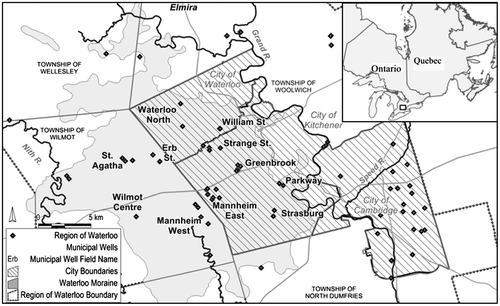
The Regional Municipality of Waterloo (the Region) lies in south-central Ontario (Figure ) and is home to about 550,000 residents. Approximately 80% of the Region’s municipal water needs are serviced by over 100 active groundwater supply wells located in 50 well fields, with the Grand River supplying the remaining 20% of the municipal water demand. Within the cities of Kitchener and Waterloo, approximately 40 municipal supply wells are completed in the multiple aquifer system located within and beneath the Waterloo Moraine. Bajc et al. (Citation2014, this issue) describe a three-dimensional lithostratigraphic model developed using geologic information from a regional borehole database (Farvolden et al. Citation1987; Bajc and Newton Citation2007; Bajc and Shirota Citation2007). The hydrogeologic framework described in this paper was built upon the stratigraphic model developed by Bajc and Shirota (Citation2007). The Bajc and Shirota (Citation2007) model was based primarily on geologic understanding and the structure of the overburden sediments. The current understanding of the hydrogeology of the Waterloo Moraine is described with a focus on the major municipal water supply aquifers and the key aquitards that comprise the Waterloo Moraine and underlying sediments. Enhancing the understanding of the Waterloo Moraine’s hydrogeological framework will help the Region make informed decisions regarding the management of their municipal groundwater resources.
Figure 1. Location of the Waterloo Moraine and well fields in the Waterloo Moraine.
The beginnings
Finding water
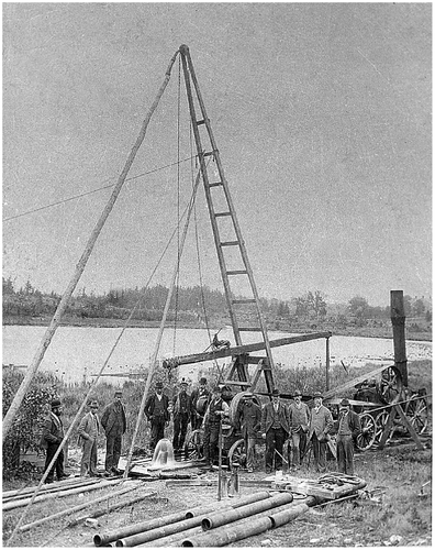
The first municipal water supply wells within the Region were constructed in 1899 at what is now the Greenbrook well field (Figure ) in Berlin, Ontario (now the City of Kitchener). Figure shows a water well being drilled near a series of springs along Shoemaker Creek in 1899. Although the first wells were drilled into the bedrock, later wells drilled at the Greenbrook well field in the late 1920s and early 1930s were completed into the sedimentary aquifer underlying the creek, which yielded water of superior quality. In the early 1900s, the City of Waterloo began developing municipal water supply wells at the William Street well field (Figure ).
Figure 2. Drilling of a water well at the Shoemaker (Greenbrook) pumping station in 1899, Berlin (now Kitchener), Ontario. Photo courtesy of the Region of Waterloo and the Waterloo Historical Society.
Drilling of water supply wells during the first half of the twentieth century primarily occurred within the urban areas of Kitchener and Waterloo, and typically extended westward as each city expanded. The water supply wells within most of these early well fields extracted water from the overburden sediments within or beneath the Waterloo Moraine. Exploration of the deeper bedrock aquifer was limited in the Kitchener and Waterloo area due to the poor water quality associated with the underlying Salina Formation bedrock, which typically has elevated concentrations of sulphate and iron. In 1910, the first wells in the Strange Street well field (Figure ) were constructed and a pumping station was built in 1923 (Stantec Consulting Ltd. Citation2009). In the late 1940s, the City of Waterloo conducted a major exploration program in north Waterloo near the Waterloo North well field (Figure ). The majority of these early water exploration programs involved drilling exploration holes along creek valleys in search of shallow water-bearing sand and gravel units.
Mapping the Waterloo Moraine
The Waterloo Moraine name was first applied by Taylor (Citation1913) when he published the first regional map of glacial end moraines and spillways in southwestern Ontario; however, the mapped portrayals of the moraines were basic and descriptions were brief. Taylor (Citation1939) revised the mapping of the Waterloo Moraine outline using available topographic mapping and the Moraine outline was further revised by Chapman and Putnam (Citation1943, Citation1951). Geologic interpretations regarding the surficial and buried tills and intervening aquifers of the Waterloo Moraine began in the 1960s (Karrow Citation1963) and continued in the decades to follow (Karrow et al. Citation1990; Karrow Citation1993).
The emergence of science for understanding groundwater in the Waterloo Moraine
In the 1950s, levels of bacteria in the Great Lakes increased dramatically due to increased population and industrial growth, and inadequate sewage treatment and disposal. In 1956, the Ontario Water Resources Commission (OWRC) was established by the Province of Ontario with a mandate to build, finance and operate water and wastewater systems (Scott Citation1968). Concerns were raised that some inland areas in southwestern Ontario would not have adequate groundwater supplies, and pipelines from the Great Lakes would be required to supply drinking water to inland communities such as those in the Region (Scott Citation1968).
Rapid industrial expansion within the cities of Kitchener and Waterloo in the 1960s resulted in a need for new water supply sources. This led to the initiation of technical studies to investigate the local water resources, with the first scientific groundwater study undertaken by the OWRC (Dixon Citation1963). The study identified three separate aquifers and intervening aquitards in the Waterloo Moraine area; however, the understanding of the regional hydraulic connection of these aquifers and the implications for management of municipal groundwater supplies was limited. In addition, the interaction between groundwater aquifers and local streams and wetlands was also poorly understood at this time. The first geologic interpretations of the overburden geology on the eastern portions of the Waterloo Moraine were also documented at this time, and provided a strong foundation for subsequent hydrogeologic studies in the area.
The Regional Municipality of Waterloo took responsibility for the management of the municipal water supply systems in the cities of Kitchener, Waterloo, and Cambridge after being incorporated in 1973. In the early 1970s, a follow-up to the OWRC study was conducted (International Water Supply Ltd. Citation1973) and the study concluded that the aquifer system was relatively continuous across most of the Region. As part of this study, Dr. Emil Frind at the University of Waterloo developed one of the earliest groundwater flow models in the province (Frind et al. Citation2014, this issue). This initiative furthered the involvement of the University of Waterloo in the study of the groundwater resources within the Region.
The hydrogeology program at the University of Waterloo expanded in the late 1970s and early 1980s through the efforts of Dr. Robert Farvolden. Investigations shifted from examining individual well fields to the development of broad hydrostratigraphic models that furthered the understanding of the regional groundwater flow system and well field interconnections. The Region began assessing the feasibility of building a pipeline to Lake Erie, approximately 75 km to the south, to meet the projected 25-year municipal water demand for the growing population and industrial base; however, Dr. Farvolden suggested additional groundwater resources were available. He suggested efforts should be taken to improve the understanding of the water resources within the Region prior to the construction of a very expensive pipeline (Farvolden Citation1982). Local politicians were reluctant to spend money to study the area geology and in response, Dr. Farvolden (1981) stated:
Many informed geologists and engineers believe that additional groundwater supplies are available, and perhaps sufficient to meet the forecast demands. The key factor in a technical solution is better data on the Quaternary stratigraphy. Funds have not been made available for basic stratigraphic studies using modern techniques and as a consequence hydrogeology cannot be used effectively in dealing with the problem.
Dr. Farvolden’s words were taken to heart and new research programs were initiated, including Quaternary geology studies focusing on the subsurface geology beneath the urban areas of Waterloo and Kitchener and the core of the Waterloo Moraine, west of the urban areas. Deep cored boreholes and downhole geophysical techniques were used to better understand the sediment structure, depositional environments and geometry of hydrostratigraphic units of the Waterloo Moraine and underlying sediments (Pehme Citation1984; Ross Citation1986; Farvolden et al. Citation1987; Rowland Citation1991).
In the 1970s and 1980s, water resource investigations conducted by researchers at the University of Waterloo were focused on understanding the Greenbrook well field (Figure ) and the multi-aquifer system along the eastern flank of the core of the Waterloo Moraine, where urban expansion was occurring. Numerous studies were conducted using hydrogeological techniques and tools including: geologic core sampling and monitoring well installation, long-term pumping and shutdown tests within multiple aquifer units, water quality sampling during pumping tests, isotopic analysis and the development of groundwater flow models (Nowicki Citation1976; Beland Citation1977; Weitzman Citation1980; Woeller Citation1982; Lotimer Citation1984). Additional studies followed shortly thereafter examining other well fields within the Waterloo Moraine (Petrie Citation1985; Rudolph Citation1985).
The Region updated their master water supply plan from 1983 to 1987, and this included an assessment of the sustainable yields from the existing municipal wells and assessing the potential for additional water supplies through induced infiltration from the Grand River (Gevaert Citation1979). A study was also initiated to explore artificial recharge of water (aquifer storage and recovery) from the Grand River into the thick unsaturated volume of sand and gravel in the core area of the Waterloo Moraine, west of Kitchener.
Groundwater investigations from 1989 to 2002
In 1989, a municipal well field in the Town of Elmira, north of the City of Waterloo (Figure ), became contaminated, and water managers became increasingly concerned about groundwater quality and the potential vulnerability of the Region’s water supply aquifers to surface sources of contamination. Consequently, the Region developed a Comprehensive Water Resources Protection Strategy in 1992 (Golder Associates Ltd. Citation1992) to manage and protect the municipal groundwater resources. The first element of the 10-year strategy was the definition of the groundwater resources within the Region, and a comprehensive investigation of the hydrogeology of the Waterloo Moraine and associated aquifer systems. The Waterloo North Aquifer System Study (Terraqua Investigations Ltd. Citation1992) and the Study of the Hydrogeology of the Waterloo Moraine (Terraqua Investigations Ltd. Citation1995) were two key studies that delineated the major aquifer and aquitard units, defined regional recharge areas, estimated well field capture zones and estimated the effect of municipal pumping on regional aquifer groundwater levels and stream baseflows.
Water quality and isotope data were also collected throughout the Waterloo Moraine Aquifer system to refine the understanding of recharge rates, especially in the core area of the Moraine (Johnston Citation1994). Stream-bed piezometers installed within and adjacent to headwaters of the creek systems within the core area of the Waterloo Moraine assessed groundwater-surface water interactions.
Figure shows the conceptual hydrogeological cross-section of the Waterloo Moraine developed during this time (Terraqua Investigations Ltd. Citation1995), and highlights the three aquifer units and their intervening discontinuous aquitard units. The upper aquifer (Aquifer 1, Figure ) was identified as a laterally thick sand and gravel unit; many of the major municipal well fields at the time were completed within this unit. Aquitard 2 was interpreted as the Maryhill Till, a clay till that underlies most of the core area of the Waterloo Moraine and limits the flow of groundwater to depth. This unit was interpreted to be discontinuous (i.e. having erosional channels [windows] or zones of higher hydraulic conductivity) east of the core of the Waterloo Moraine, allowing water from the upper aquifers to recharge the deeper aquifers beneath the urban areas of Kitchener and Waterloo. Aquifer 2 (Figure ) was interpreted to underlie the Maryhill Till and to consist of glaciofluvial deposits associated with the underlying Catfish Creek Drift.
Figure 3. Conceptual hydrogeological model of the Waterloo Moraine (modified from Terraqua Investigations Ltd. Citation1995).
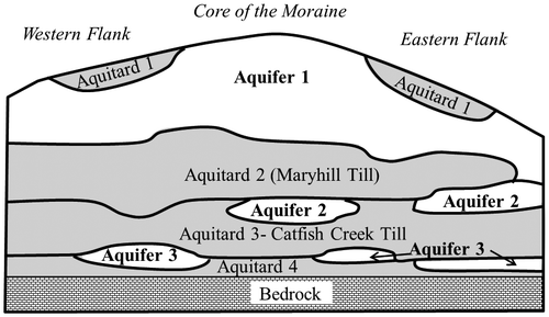
Aquitard 3 (Figure ) was interpreted as the coarse-grained, overconsolidated Catfish Creek Till, located below the Lower Maryhill Till. The Catfish Creek Till was interpreted as a poor aquitard that has a sharp contact with the overlying till in areas where Aquifer 2 is absent. This sharp geologic contact was used to correlate hydrostratigraphic units across the Region as it produces a distinct geophysical signature (Pehme Citation1984). A discontinuous aquifer (Aquifer 3, Figure ) was interpreted to underlie the Catfish Creek Till, and was mapped as being more prevalent along the eastern flank of the Waterloo Moraine beneath the urban areas of Kitchener and Waterloo (Figure ). Aquitard 4 was interpreted as a clay till unit, occasionally identified as being present along the eastern flank of the Waterloo Moraine, typically separating Aquifer 3 from the underlying bedrock. The upper bedrock was interpreted to be Aquifer 4.
The conceptual hydrostratigraphic model presented in this study (Terraqua Investigations Ltd. Citation1995) was refined by Karrow (Citation1990) and Karrow et al. (Citation1993), with a focus on the regionally extensive till units, in particular the Lower Maryhill and Catfish Creek Tills, as a basis for geologic correlations. Additional studies on the Quaternary stratigraphy and depositional history of the Waterloo Moraine sediments were conducted at the University of Waterloo under the direction of Dr. Karrow (Paloschi Citation1993; Rajakaruna Citation1994; Gautrey Citation1996). Amongst other technical benefits and insights, these studies documented the subdivision of the upper Waterloo Moraine aquifer (Aquifer 1) in two distinct facies: a silty fine sand prevalent in the north and sand and gravel facies in the southern portion of the Waterloo Moraine.
Research projects conducted during the 1990s and early 2000s further refined the understanding of the hydrostratigraphy of the Waterloo Moraine and underlying sediments (Fitzpatrick Citation1993; Martin Citation1994; Johnston Citation1994; Callow Citation1996; Martin and Frind Citation1998; Muhammad Citation2000), and helped manage and protect the aquifer systems as part of the Region’s Water Resources Protection Strategy. In the mid- to late 1990s, two-dimensional groundwater flow models were developed (Waterloo Hydrogeologic Inc. Citation1996) to delineate capture zones for individual well fields within the Waterloo Moraine. Further refinement of the well field capture zones was completed between 1995 and 2000, using three-dimensional numerical models of the Waterloo Moraine area (Waterloo Hydrogeologic Inc. Citation2000; Frind et al. Citation2002). These capture zones, and those delineated in subsequent studies (e.g. AquaResource Citation2010) formed the basis for developing defendable groundwater protection zones there were incorporated into the Region of Waterloo Official Plan (Blackport and Dorfman Citation2014, this issue).
In the 1990s, there was an increased awareness of the potential reduction in groundwater discharge and stream flow to surface water features due to increased groundwater pumping and reductions in recharge due to land use development. As a result, watershed and subwatershed studies were undertaken and recommended ecosystem-based planning approaches to urban development and growth. These studies examined the interaction between the groundwater flow system and the various components of the ecological systems including cold-water fisheries and aquatic ecosystems. Watershed studies were conducted on the headwater streams of the Waterloo Moraine including Laurel Creek (1991), Strasburg Creek (1989 and 1996), Doon South (1994) and Blair, Bechtel and Bauman Creeks (1997).
Recent hydrogeological initiatives, 2003 to present
In the year 2000, a municipal well in the rural community of Walkerton, Ontario, became contaminated with a dangerous strain of E. coli bacteria that resulted in the death of seven residents and associated long-term illnesses for approximately 2500 of the 5000 town residents. This tragedy led to the Walkerton Inquiry and the O’Connor Report (O’Connor Citation2002), and shortly thereafter, the Clean Water Act received Royal Assent in 2006 (Province of Ontario Citation2006). The Clean Water Act aims to protect the quality and quantity of municipal drinking water supplies and prevent the tragedy that occurred in Walkerton from happening again. In addition, the Ontario Geological Survey (OGS) initiated a program to provide geoscience information that would help protect and preserve the Province’s groundwater resources (Bajc and Newton Citation2007; Bajc and Shirota Citation2007; Bajc et al. 2014, this issue). Three-dimensional mapping of overburden deposits within the Region was one of the projects initiated by the OGS in 2002, using new mapping tools, in collaboration with the Geological Survey of Canada, the Region, the University of Waterloo and the Grand River Conservation Authority. From this mapping, a three-dimensional geologic model of the overburden units beneath the Region was developed (Bajc and Shirota Citation2007).
In 2005, the Region initiated the Integrated Urban System (IUS) Supply Optimization and Expansion Project to develop additional water supplies from existing and underutilized municipal supply wells, to augment the existing water supplies. Site-specific studies were conducted across the Waterloo Moraine area, and these included drilling high-quality boreholes (i.e. continuous geologic sampling), and the collection of water level and water quality data, as well as hydraulic testing (Golder Associates Ltd. Citation2009, Citation2010a, Citation2010b, Citation2010c). These studies used extensive and sophisticated investigations to better understand the potential impacts of water taking on the natural environment to address growing public and agency concerns. Pumping tests and well shutdown tests that were often longer than 30 days were conducted, and dozens of data loggers within the multiple aquifers, and within and below creeks and wetlands, were monitored throughout the tests.
Technical studies in support of the Clean Water Act began in 2006 to examine potential threats to the drinking water quality and quantity within the Region. Water budget studies were initiated for the Grand River watershed, using a tiered framework; Tier One Water Budgets and Tier Two Water Budget and Subwatershed Stress Assessments evaluated the potential for hydrological stresses in subwatersheds within the Grand River watershed. The regional-scale Tier Two Water Budget study (AquaResource Citation2009a) identified two subwatersheds where more detailed water budget assessments should be completed to evaluate the ability of the water supply aquifers to meet current and future drinking water demands on a local, or well field scale (Meyer et al. Citation2014, this issue). The more detailed local-scale study, referred to as the Tier Three Water Budget and Local Area Risk Assessment (Tier Three Assessment), began in 2008 and was funded by the Province of Ontario. The regional-scale geologic model developed by Bajc and Shirota (Citation2007) was refined at the well field scale and used in the calibration and application of a three-dimensional groundwater flow model (Meyer et al. Citation2014, this issue).
The current understanding of the hydrostratigraphy
Bajc and Shirota (Citation2007) developed their stratigraphic model using a variety of data sources including: subsurface geological and geophysical data, published information on the Quaternary geology, logging of archived core, examination of available sediment exposures, drilling and logging of new geologic cores. From a hydrogeological perspective, the model layers developed by Bajc and Shirota (Citation2007) are considered stratigraphic layers, rather than hydrostratigraphic layers, as hydrogeological data such as hydraulic head measurements, hydraulic test observation data and water quality data were not used in the model layer development or interpretation. Hydrogeological data provides additional insight into the spatial continuity of geologic units at surface or at depth, and also sheds light on the hydraulic connections between aquifer units.
Given the Region’s reliance on groundwater for potable water supply, and the close link between the geological and hydrogeological interpretations, the stratigraphic interpretations of Bajc and Shirota (Citation2007) formed the foundation for the development of the hydrogeological model of the Waterloo Moraine. The subsurface units within and beneath the Waterloo Moraine, as described by Bajc and Shirota (Citation2007), are outlined in Table .
Table 1. Hydrostratigraphic overburden units within and beneath the Waterloo Moraine and surrounding areas.
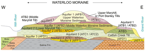
Refinements were made to the three-dimensional stratigraphic model by Bajc and Shirota (Citation2007) at the well field scale to ensure the interpreted hydrostratigraphic layers (i.e. the thickness and elevation of aquifers and aquitards) were consistent with available hydrogeological data at each of the urban well fields. The geologic and hydrogeological interpretations within and surrounding the Region’s municipal well fields were refined, with the generation and interpretation of over 100 hydrostratigraphic cross-sections (Blackport Hydrogeology Inc. Citation2012a, Citation2012b; Golder Associates Ltd. Citation2011; Stantec Consulting Ltd. Citation2009, Citation2012a, Citation2012b, Citation2012c). The hydrostratigraphic cross-sections were interpreted using hydrogeological databases and datasets containing: municipal pumping data, hydraulic head data, water quality data from municipal wells and monitoring wells, isotope data, well field shutdown data and hydrostratigraphic layer “picks” from Bajc and Shirota (Citation2007). Figure illustrates a conceptual hydrostratigraphic cross-section through the Waterloo Moraine that better reflects the variability in the individual hydrostratigraphic units, which previously were conceptualized as consistent and continuous layers within and beneath the Moraine. The nomenclature illustrated in Figure is from both the hydrostratigraphic interpretation historically used by the Region (see Terraqua Investigations Ltd. Citation1995) and the interpretation by Bajc and Shirota (Citation2007). In the naming convention used by Bajc and Shirota (Citation2007) in Figure , aquifers are identified by “AF” followed by a letter and number (e.g. AFB1), while aquitards are identified with an “AT” followed by a letter and a number (e.g. ATB2). The additional letter and number correspond to the sequence of hydrostratigraphic units, whereby “A” represents the youngest units in the Waterloo Moraine and “F” represents the oldest units.
Figure 4. Current conceptual hydrogeological model of the Waterloo Moraine.
Hydrogeological characteristics of key hydrostratigraphic units
As outlined in the previous sections, the sediments within and beneath the Waterloo Moraine have been studied for decades. As new data are collected, the interpretation of the various hydrostratigraphic units changes, and the conceptual understanding of the hydrogeology continues to evolve. Although the general stratigraphic structure of the Waterloo Moraine has not evolved dramatically over the past few decades, the conceptual understanding of the groundwater flow system has been refined, particularly with respect to hydraulic interconnections between the primary aquifers, and between the upper aquifer and the surface water features. The Waterloo Moraine sediments were laid down in an interlobate and ice-contact environment (see Bajc et al. Citation2014, this issue) and, as such, the hydrostratigraphic units are typically spatially discontinuous and heterogeneous, which complicates the characterization of the hydrogeology of the system. Transmissivity estimates derived from hydraulic tests of the Waterloo Moraine Aquifers range from 20 m2/day to 4500 m2/day, which creates challenges when conducting groundwater exploration programs or optimizing the water taking from individual well fields.
Sediments present at and near the ground surface control the rate of recharge to the underlying aquifer systems. The lateral and vertical connections of aquifer units control groundwater flow to specific geographic areas such as well fields. These connections also can impact water quality, as windows in confining units may hydraulically connect intermediate aquifers to surface sources of contamination, or to poor water quality associated with underlying bedrock aquifers. The following sections outline the hydrogeological characteristics of the key aquifers and aquitards within and beneath the Waterloo Moraine, and how they influence the groundwater flow, water quality and, ultimately, the management of municipal water demand within the Region.
Surficial (upper) aquitard
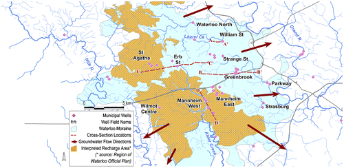
The surficial (upper) aquitard is a key hydrostratigraphic unit as its presence and hydraulic characteristics control the rate of recharge to the underlying Waterloo Moraine aquifers, as well as the migration of potential surface sources of contamination to these aquifers. Bajc and others (Citation2014, this issue) group many younger till units (e.g. Port Stanley, Upper Maryhill and Tavistock Tills) that are present at or near the ground surface into a single stratigraphic unit (ATB1; Figure ). This unit is generally less than 20 m thick within the Region, and the hydraulic conductivity is estimated to be highly variable and range from 1 × 10⁻⁷ m/s to 1 × 10⁻⁹ m/s, due to the wide range of grain-size distribution within the matrix of the tills. Where the surficial aquitard is present, there is limited recharge to the underlying Waterloo Moraine aquifers. Recharge rates on the Moraine were estimated to range from less than 50 mm/year in heavily urbanized areas where a surface aquitard is mapped, to over 450 mm/year in areas where coarse-grained, hummocky sands and gravels are mapped at surface (AquaResource Citation2009b). The distribution and thickness of the upper aquitard was mapped by the OGS (Figure ; adapted from Bajc and Shirota Citation2007). The mapping suggests the surficial aquitard is absent across much of the core area of the Waterloo Moraine, west of the urban area, where significant volumes of water recharge the underlying Waterloo Moraine aquifers. Much of this area is hummocky, and a regional topographic high, which results in decreased runoff and increased infiltration. Much of this area is designated as a Regional Recharge Area for the Waterloo Moraine and associated regional well fields (Figure ). The Regional Recharge Area was incorporated into the current Regional Official Plan (Region of Waterloo Citation2010) as a groundwater protection area, given its importance in providing water to many of the Region’s well fields (Blackport and Dorfman Citation2014, this issue). Incorporating this feature into the Official Plan created an increased level of planning protection from surface sources of contamination and from loss of recharge function. (It is noted that the adopted Regional Official Plan was under review at the time of preparation of this paper.) The Region used the following criteria to delineate the recharge areas associated with the Waterloo Moraine: areas where permeable geologic materials (e.g. sand and gravel) exist at or near ground surface, or areas where less than 2 m of lower permeable geologic materials overlie these permeable geologic materials, and land areas which drain surface runoff into either of the two previously noted areas.
Figure 5. Distribution and thickness of the surficial aquitard (ATB1) (adapted from Bajc and Shirota 2007; reproduced and adapted with permission, Queen’s Printer for Ontario).
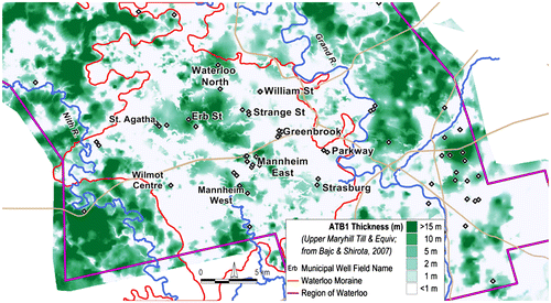
Figure 6. Regional recharge area, as designated for the approved (with modifications) Region of Waterloo Official Plan (adapted from Region of Waterloo 2010).
Upper Waterloo Moraine aquifers
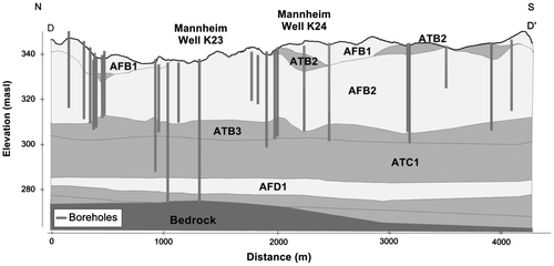
Bajc et al. (Citation2014, this issue) interpreted the Waterloo Moraine aquifers as three distinct aquifer units (AFB1, AFB2 and AFB3; Figure ), located between the surficial aquitard (ATB1) and the underlying Catfish Creek Till (ATC1; Figure ). Historically, hydrogeological investigations treated the upper two aquifer units (AFB1 and AFB2) as one major aquifer, especially in the core of the Waterloo Moraine (Figure ), although more recent investigations show that these units are separated by a lower-hydraulic conductivity unit in some areas (CH2MHill Canada Citation2003). Bajc et al. (Citation2014, this issue) noted that the working face of gravel pits in the Mannheim area often contains a thin, discontinuous layer of fine-grained diamicton within the sand and gravel sequence.
The Upper Waterloo Moraine aquifers in the core area of the Waterloo Moraine consist of a thick saturated and unsaturated sand and gravel unit that typically exceeds 45 m in thickness. This thickness of sand and gravel, combined with high recharge rates and limited leakage through the underlying Lower Maryhill Till (Figure ), results in an aquifer with a large storage capacity, especially within the unsaturated zone, that is continually being replenished. Due to the thickness and broad lateral distribution, the Upper Waterloo Moraine aquifers are the most transmissive and prolific groundwater aquifers in the Region. Four major well fields – Mannheim West, Mannheim East, Erb Street and Wilmot Centre (Figure ) – obtain water from the Upper Waterloo Moraine aquifers in the core area of the Waterloo Moraine. The total permitted water taking from these well fields is 773 L/s with an average pumping rate in 2012 of 427 L/s. The transmissivity of the upper aquifers typically ranges from 1300 m2/day to 4500 m2/day (Golder Associates Ltd. Citation2011; Stantec Consulting Ltd. Citation2012a).
Figure shows a geologic cross-section through the Mannheim West well field and a series of municipal wells completed in the Upper Waterloo Moraine aquifers (AFB1 and AFB2). The thickness of sand and gravel sediment in this well field reaches up to 40 m, including the unsaturated zone. The Upper Maryhill Till is largely absent in this area, resulting in high recharge rates in the vicinity of the well fields, ranging from 200 mm/year to over 450 mm/year (AquaResource Inc. Citation2009b). The lack of a surface aquitard results in limited natural protection for the aquifers, making much of the core area of the Waterloo Moraine and associated well fields vulnerable to surficial sources of contamination, such as road salt and fertilizers. Some of the wells in the Mannheim well field have elevated nitrate concentrations (typically 4 to 8 mg/L) that are attributed to nearby agricultural activities. Increasing trends in sodium and chloride concentrations over the last 20 years are also apparent in some wells, attributed to the road-salting activities in the new development areas of Kitchener (Golder Associates Ltd. Citation2011). The Region has undertaken several initiatives to minimize the impact of surface sources of contamination, including a Rural Water Quality Program that aims to improve and protect water quality on farms in the Region, and Salt Management Plans and Microbial Contamination Control Plans for well fields where groundwater may be under the direct influence of surface water (Region of Waterloo Citation2008).
Figure 7. Geologic cross-section through the Mannheim West well field.
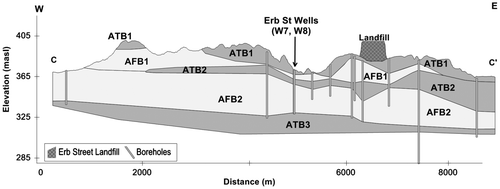
In contrast to the Mannheim well fields, the Erb Street well field (Figure ), located north of Mannheim, has a thick surface aquitard (ATB1 and ATB2; Figure ) that reduces the vulnerability of the municipal aquifer to surface sources of contamination. The Erb Street well field captures water from the upgradient parts of the Regional Recharge Area, primarily to the north and west of the well field (Figure ). Water quality in this well field is generally good despite the well field being surrounded by agricultural fields and lying adjacent to a municipal landfill (Figure ). Nitrate concentrations are typically less than 1.0 mg/L in three of the four wells in the well field, and the fourth well shows a slight increasing trend from 1.6 mg/L to 3.3 mg/L over the last 25 years (Stantec Consulting Ltd. Citation2012a). Chloride concentrations have typically been less than 20 mg/L.
Figure 8. Geologic cross-section through the Erb Street well field.
The Region uses the thick unsaturated zone of the Upper Waterloo Moraine aquifer near the Mannheim East well field (Figure ) to augment the municipal water supplies through an Aquifer Storage and Recovery system (ASR). Water is extracted from the Grand River during peak flow periods, treated to drinking water standards and then injected into the Upper Waterloo Moraine aquifers. Water is injected by gravity through a series of upgradient wells and is pumped at a later date to supplement peak demands (CH2MHill Canada Ltd. Citation2003), typically experienced during the summer months. Not all of the injected water is recovered, as some mixing of the natural groundwater with the recharge water occurs as the groundwater flows hydraulically away from the ASR site. The average injection to the groundwater system in 2012 was 28 L/s on an annual basis; however, the total volume injected and recovered for municipal water supply may be increased in the future.
In addition to supplying water to the well fields in the core area of the Waterloo Moraine, groundwater flows laterally away from the recharge area in the Upper Waterloo Moraine aquifers, supplying baseflow to the local headwater streams as well as water to other well fields in Kitchener and Waterloo. Figure shows the headwater streams in the core area of the Waterloo Moraine, including cold-water streams such as Alder Creek, Strasburg Creek and Laurel Creek, that are reliant on this baseflow to maintain cold-water fish communities such as brook trout. The Mannheim West, Strasburg and Waterloo North well fields are located in close proximity to headwater creeks. From a water management perspective, water withdrawal from these well fields for municipal supply is balanced with water needed to maintain groundwater discharge to preserve the ecological integrity of the creek systems. Intensive groundwater and surface water monitoring programs and well-field pumping tests identified linkages between the groundwater and surface water systems and this information is incorporated into the management of each well field to ensure water demands are sustainable from an ecosystem health perspective.
Lower Maryhill Till
The Lower Maryhill Till (ATB3 and Aquitard 2; Figure ) strongly influences the groundwater flow system within the Waterloo Moraine. The Maryhill Till is a clayey silt to silty clay till with a vertical hydraulic conductivity typically less than 1 × 10⁻⁹ m/s (Petrie Citation1985). A thick layer of Lower Maryhill Till underlies much of the core area of the Waterloo Moraine, limiting recharge to depth, resulting in much of the recharge water moving laterally through the Upper Waterloo Moraine aquifers.
Where the Lower Maryhill Till is extensive, especially in the core area of the Waterloo Moraine, municipal water is obtained primarily from the overlying Upper Waterloo Moraine aquifers (see Figures and ). Along the eastern flank of the core of the Waterloo Moraine (i.e. the urban areas of Kitchener and Waterloo), where this till is thin or absent, most municipal well fields obtain at least a portion of their production from the lower aquifers. The productivity of these aquifers is in part a function of the degree of hydraulic connection with the overlying aquifers, primarily where the Lower Maryhill Till thins or is absent.
Lower Waterloo Moraine aquifer
The Lower Waterloo Moraine aquifer (AFB3 and Aquifer 2; Figure ) is spatially limited beneath the core of the Waterloo Moraine, and it is difficult to correlate laterally over any significant distance beneath the rest of the Waterloo Moraine. Historically, this aquifer was interpreted to be well protected from surface sources of contamination given the protection by overlying aquitards (Terraqua Investigations Ltd. Citation1995). Refinement of the hydrostratigraphy through the collection of additional geologic data and assessment of long-term water quality data showed a number of windows (e.g. erosional channels) or zones of higher hydraulic conductivity present in the overlying aquitards, allowing greater leakage of water from the shallower groundwater system to the lower aquifers. Where windows are present, the upper and lower aquifers are hydraulically connected and the Lower Waterloo Moraine aquifer is typically very productive. A high-productivity zone is present at the William Street well field (Figure ) and transmissivity estimates area in the vicinity of the well field range from 1060 to 1970 m2/day (Conestoga-Rovers & Associates Ltd. Citation1987). Figure shows a geologic cross-section through the William Street well field, showing the limited extent of the Lower Maryhill Till (ATB3) in the vicinity of the well field.
Figure 9. Geologic cross-section through the William Street well field.
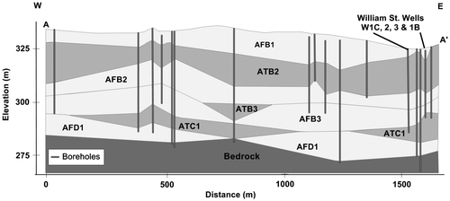
Although windows in the aquitards have allowed water to flow downwards into the William Street production aquifer, the presence of these windows or erosional channels impacts the water quality at the well field. A thin, shallow aquitard (ATB2) is present directly above the municipal aquifer, providing a level of protection (Figure ); however, this aquitard pinches out just outside the well field area. The trend over the last 30 years has been toward increasing sodium and chloride concentrations, attributed to winter road-salting practices in the central area of the City of Waterloo, where major roads and parking lots intersect. Chloride concentrations have increased from less than 100 mg/L in the early 1980s to over 300 mg/L in several of the William Street wells (Blackport Hydrogeology Inc. Citation2012b). One of the William Street municipal wells is also impacted by historical industrial contamination, with low levels of organic contamination present (Golder Associates Ltd. Citation2010b). The variation in water quality (e.g. concentrations of chloride, sodium and sulphate, and hardness) between the pumping wells complicates the operations of this well field, and individual well pumping rates are varied to optimize the quality of water mixed in the William Street reservoir before entering the distribution system.
Catfish Creek Till aquitard
The Catfish Creek Till (ATC1 and ATC2; Figure ) is a dense, stony, silty to sandy till. Bajc et al. (Citation2014, this issue) describes the till as being deposited by subglacial lodgement processes with subordinate ice-marginal debris flow and waterlain facies. They also suggest some saturated deposits could act as aquifers (AFC1). The Region’s hydrostratigraphic model describes the Catfish Creek Till as a poor aquitard (Aquitard 3; Figure ), with some zones being very dense (i.e. over-consolidated) and fractured, allowing some vertical transmission of water through it, while other zones contain sufficient sand and gravel to act as an aquifer unit (Terraqua Investigations Ltd. Citation1995). The hydraulic conductivity of the Catfish Creek Till is variable, typically ranging from 1 × 10⁻⁶ m/s to 1 × 10⁻⁸ m/s (Blackport Hydrogeology Inc. 2012b). The Catfish Creek Till is generally the thickest in the core area of the Waterloo Moraine and typically thin or absent along the eastern flank, beneath Kitchener and Waterloo, and often contains erosional channels or windows. The William Street well field is an example of an interpreted erosional window within the Catfish Creek Till (Figure ) resulting in a hydraulic connection between the Lower Waterloo Moraine aquifer and the underlying Pre-Catfish Creek aquifer (AFD1).
The Greenbrook well field is an example of one of the few areas where the Catfish Creek aquifer (AFC1) is present as part of the Catfish Creek Till (Figure ). This aquifer, where interpreted to be present by Bajc and Shirota (Citation2007), is combined with the Pre-Catfish Creek aquifer (AFD1) in the Region’s hydrostratigraphic model (Aquifer 3; Figure ). The Greenbrook well field has been studied for decades with more than 50 boreholes drilled and 70 monitoring wells installed (Stantec Consulting Ltd. Citation2012b). The Lower Maryhill Till and Catfish Creek Till were usually encountered in borehole logs drilled within the well field, implying limited hydraulic connection between the deeper production aquifer and the Upper Waterloo Moraine aquifers (Figure ). Long-term water quality data from municipal wells in the deeper aquifers suggest a more significant hydraulic connection, as water quality trends show an impact from surface sources of contamination. In particular, chloride concentrations have steadily increased since 1975 at several of the Greenbrook municipal wells, from less than 50 mg/L to over 250 mg/L, suggesting road salt is migrating from the surface to the deeper aquifers (Stantec Consulting Ltd. Citation2012b). Bester et al. (Citation2006) used modelling to assess the potential migration of chloride plumes from the surface to the Greenbrook well field production wells, and how chloride concentrations in the wells can be reduced via salt management or reduction programs.
Figure 10. Geologic cross-section through the Greenbrook well field.
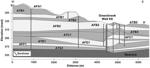
The Greenbrook well field was shut down for several months in 2004, due to groundwater contamination issues. During this time, water levels rose to ground surface in some local low-lying areas near the well field, indicating a hydraulic connection between the deeper production aquifers and the shallow surficial aquifer. Water levels recovered to elevations similar to original water levels in the aquifers, indicating that even after 100 years of pumping, the groundwater resources in this area have not been depleted. In spite of this, long-term water management of this well field requires careful balancing of pumping rates to account for water quality and water level variability within the aquifer system.
Pre-Catfish Creek Till aquifers
Pre-Catfish Creek Till aquifers are typically classified together as one aquifer (AFD1 and Aquifer 3; Figure ) and supply water to some or all production wells in the Greenbrook, Parkway, Strasburg, William Street and Waterloo North well fields (e.g. Figures and ). These well fields produce up to 300 L/sec, with most of the water coming directly from this aquifer and supplemented through hydraulic connections to overlying aquifers. The transmissivity of this aquifer ranges from about 130 m2/day at the Greenbrook well field to greater than 4000 m2/day at the Strasburg well field (Stantec Consulting Ltd. Citation2012c).
Canning Till (drift) aquitard
The Canning Till (ATE1 and Aquitard 4; Figure ) is described by Bajc and Shirota (Citation2007) as till and associated fine-textured lake deposits that are discontinuous beneath much of the Waterloo Moraine. The Region’s hydrostratigraphic interpretation combines the Canning Till (ATE1) and Pre-Canning tills (ATG1) together as Aquitard 4 (Figure ). There is a limited characterization of this aquitard as few wells have been drilled to the depth of this aquitard, which is typically found at greater than 70 m deep in the Waterloo Moraine, given the abundance of water in the aquifers overlying this unit. Available lithologic data suggests this aquitard is of limited lateral extent and thickness and, where absent, a hydraulic connection is present between deep overburden aquifers and the underlying bedrock, which has poor-quality water. The William Street well field is an example where this aquitard unit is absent (Figure ). If the municipal wells in the lower overburden aquifers are pumped at a sufficient rate to induce an upward hydraulic gradient, bedrock water is drawn into the overlying aquifers, typically resulting in an increase in sulphate, hardness and iron in water pumped from the deeper production wells. As previously indicated, municipal demands must be managed appropriately to minimize sudden changes in water quality.
Pre-Canning Till aquifers
There are limited data on the Pre-Canning Till aquifers (AFF1 and Aquifer 4; Figure ), especially in the core area of the Waterloo Moraine, as there has been limited drilling through the entire thickness of overburden sediments in the core area of the Waterloo Moraine (typically greater than 100 m). These aquifer sediments are found mainly along the Grand River valley and are typically in contact with the Pre-Catfish Creek aquifers, making it difficult to distinguish between these units, although locally thin sheets of Canning Till may separate them (Bajc and Shirota Citation2007). The Region has three well fields located adjacent to the Grand River and which, given their shallow depth relative to the Grand River (10–15 m below ground surface), are hydraulically connected to the Grand River. These well fields were developed as part of an exploration program in the 1970s (Gevaert Citation1979) to create a series of induced infiltration wells along the Grand River. Currently, only one of the well fields is operated on occasion due to water quality constraints.
Implications for the sustainability of the resource
The aquifers and aquitards within and beneath the Waterloo Moraine form a large multi-layer hydrostratigraphic system with various lateral and vertical connections between these units. The depositional environments within which the aquifers and aquitards were laid down were highly dynamic and, as such, significant spatial variability exists within individual geologic units. This variability makes water supply exploration and characterizing and interpreting the groundwater system difficult; however, groundwater studies completed over the past 40 years have greatly improved the understanding of the spatial distribution of the municipal aquifers within and beneath the Waterloo Moraine.
The groundwater flow system is dynamic and influenced by the location and rate of groundwater recharge, and also the location and volume of water taking throughout the aquifer system. Municipal water supply well fields are widely distributed across the Waterloo Moraine area (Figure ). Deciding where and how much water to withdraw from each aquifer without impacting other municipal wells or sensitive surface water features is a difficult task. The Region reviews hydraulic head data on an ongoing basis and uses this information to balance pumping rates among many wells to meet the water demands, while ensuring that water levels in pumping wells do not fall below critical levels and sensitive surface water features are not impacted.
Monitoring of water levels during long-term pumping tests and well field shutdowns, combined with groundwater flow modelling, has shown that several of the Region’s well fields are hydraulically connected to one another, and most overburden well fields are fed partly or entirely by water recharging the groundwater system from the core area of the Waterloo Moraine, where a Regional Recharge Area (Figure ) was designated by the Region within the Regional Official Plan. The Erb Street, Strange Street, Greenbrook and William Street well fields (Figure ) are hydraulically connected to one another, despite the fact the municipal wells are completed in several aquifer units. Similarly, the Parkway and Strasburg well fields have been shown to be hydraulically connected to the Mannheim West and East well fields. As a result, decisions regarding operation and management of these groups of municipal well fields are most effectively completed on a larger scale to ensure the interconnections and linkages are taken into account. These are the well field linkages, as currently interpreted from existing data and under current operating conditions; however, these linkages may change in the future if there is increased water taking, through increased pumping or through the addition of new water supply wells, or from a decrease in groundwater recharge rates due to land-use changes. Climate change or variability may also have an impact on the water supplies available for ecological systems and municipal or non-municipal water takers.
In addition to the water quantity challenges, the Region is also responsible for addressing water quality concerns. Water quality challenges faced by the Region include those derived from natural sources, such as iron from some deep overburden wells, while other more significant concerns are derived from anthropogenic sources. A detailed discussion of actual and potential water quantity/quality threats and mitigation approaches is provided by Sousa et al. (Citation2014, this issue).
Conclusions
This paper outlined the evolution of the hydrogeological understanding of the Waterloo Moraine and the underlying sediments from the initial studies in the 1960s to the present day. Understanding the spatial distribution of aquifers and aquitards and the interconnections between well fields allows the Region to make informed water resource management decisions that balance the water quality and quantity challenges within the Region.
Managing and protecting the groundwater supplies for about 550,000 residents, while preserving the ecological health of countless wetlands and streams dependent on groundwater discharge, is challenging. The municipal water resources within the Region are being proactively managed through intensive groundwater quantity and quality monitoring programs, water budgeting using computer-assisted tools and the implementation of operational measures within the fully integrated urban water supply and distribution system. While the Waterloo Moraine has been studied for over five decades, the continuous evolution in the understanding of the subsurface will allow the Region to grow and continue to meet their municipal, non-municipal and ecological water demands over the short term and the long term. Future water management will require a greater integration of geological and hydrogeological data to further refine protection measures and guide exploration efforts in order to optimize additional water taking and minimize potential impacts on sensitive ecological systems.
Acknowledgements
This paper was supported by the Groundwater Geoscience Program, Geological Survey of Canada, and Natural Resources Canada. Much of the original scientific information on the Waterloo Moraine referenced in this review was obtained through collaborative efforts, over many years, between the Region of Waterloo, University of Waterloo, the Grand River Conservation Authority, the City of Waterloo and the City of Kitchener through a variety of support from the Region of Waterloo, the Province of Ontario, the Natural Sciences and Engineering Research Council of Canada, the Ontario Geological Survey and the Geological Survey of Canada. The Region of Waterloo provided data on the operation of the well fields. The authors would like to thank reviewers Andy Bajc, John Petrie and Paul Karrow, who provided detailed constructive comments that greatly enhanced the quality of the manuscript.
References
- AquaResource Inc. 2009a. Integrated water budget report. Report prepared for the Grand River Conservation Authority. Breslau, ON: AquaResource Inc.
- AquaResource Inc. 2009b. Tier Three Water Budget and Local Area Risk Assessment: Hydrological model update, Regional Municipality of Waterloo and City of Guelph. Draft submitted to the Region of Waterloo. Breslau, ON: AquaResource Inc.
- AquaResource Inc. 2010. Region of Waterloo capture zone delineation study. Report prepared for the Regional Municipality of Waterloo. Breslau, ON: AquaResource Inc.
- Bajc, A. F., and M. J. Newton. 2007. Mapping the subsurface of Waterloo region, Ontario, Canada: An improved framework of Quaternary geology for hydrogeological applications. Journal of Maps: 219–230.
- Bajc, A. F., H. A. J. Russell, and D. R. Sharpe. 2014. The geologic setting and hydrostratigraphic architecture of the Waterloo Moraine area, Southern Ontario, Canada. Canadian Water Resources Journal 39(2): doi: 10.1080/07011784.2014.914794.
- Bajc, A. F., and J. Shirota. 2007. Three-dimensional mapping of surficial deposits in the Regional Municipality of Waterloo, southwestern Ontario. Groundwater Resources Study 3. Sudbury, ON: Ontario Geological Survey.
- Beland, A. 1977. Management of the greenbrook well field. M.Sc. Thesis, University of Waterloo.
- Bester, M. L., E. O. Frind, J. W. Molson, and D. L. Rudolph. 2006. Numerical investigation of road salt impact on an urban well field. Ground Water 44(2): 165–175.
- Blackport Hydrogeology Inc. 2012a. Tier Three Water Budget and Local Area Risk Assessment: River wells; Pompeii, Woolner and Forwell well fields characterization study. Report prepared for the Regional Municipality of Waterloo. Waterloo, ON: Blackport Hydrogeology Inc.
- Blackport Hydrogeology Inc. 2012b. Tier Three Water Budget and Local Area Risk Assessment: Waterloo North, William Street and Lancaster well fields characterization study. Report prepared for the Regional Municipality of Waterloo. Waterloo, ON: Blackport Hydrogeology Inc.
- Blackport, R. F., and L. Dorfman. 2014. Developing science-based policy for protecting the Waterloo Moraine Groundwater Resource. Canadian Water Resources Journal 39(2): doi: 10.1080/07011784.2014.914803.
- Callow, I. P. 1996. Optimizing aquifer production for multiple wellfield conditions in Kitchener, Ontario. M.Sc. Thesis, University of Waterloo.
- CH2MHill Canada Ltd. 2003. Final report, Mannheim ASR project, Stage 1 – Conceptual design report, May, 2003. Report prepared for the Regional Municipality of Waterloo. Kitchener, ON: CH2M HILL Canada Ltd.
- Chapman, L. J., and D. F. Putnam. 1943. The moraines of southern Ontario. Transactions Royal Society of Canada Section 4(37): 33–41.
- Chapman L. J., and D. F. Putnam. 1951. The physiography of southern Ontario. University of Toronto Press, ON: Ontario Research Foundation.
- Conestoga-Rovers & Associates Ltd. 1987. Additional hydrogeological investigations, William Street pumping station, Waterloo, Ontario. Report prepared for the Regional Municipality of Waterloo. Waterloo, ON: Conestoga-Rovers & Associates Ltd.
- Dixon, V. R. 1963. Kitchener groundwater survey. Toronto, ON: Ontario Water Resources Commission.
- Farvolden, R. N. 1982. Groundwater supplies for Waterloo Region: The role of geology. St. John's, Newfoundland: Geological Association of Canada.
- Farvolden R. N., J. P. Greenhouse, P. F. Karrow, P. E. Pehme, and L. C. Ross. 1987. Ontario Geoscience Research Fund Grant 128, Subsurface Quaternary stratigraphy of Kitchener-Waterloo, using borehole geophysics. OFR5623. Sudbury, ON: Ontario Geological Survey.
- Fitzpatrick, P. N. 1993. Groundwater flow and contamination at Kitchener-Waterloo, Ontario. M.A.Sc. Thesis, University of Waterloo.
- Frind, E. O., J. W. Molson, M. R. Sousa, and P. J. Martin. 2014. Insights from four decades of model development on the Waterloo Moraine, a review. Canadian Water Resources Journal 39(2): doi: 10.1080/07011784.2014.914799.
- Frind, E. O., D. S. Muhammad, and J. W. Molson. 2002. Delineation of three-dimensional capture zones in complex multi-aquifer systems. Ground Water 40(6): 586–589.
- Gautrey, S. 1996. The hydrostratigraphy of the Waterloo Moraine. M.Sc. Thesis, University of Waterloo.
- Gevaert, D. 1979. Location and evaluation of induced infiltration sites near the Grand River in the Kitchener-Waterloo area. M.Sc. project, University of Waterloo.
- Golder Associates Ltd. 1992. Water resources protection strategy. Prepared for the Regional Municipality of Waterloo. Mississauga, ON: Golder Associates Inc.
- Golder Associates Ltd. 2009. Report on IUS groundwater supply optimization and expansion project, Tasks C1, D1 and D4: hydrogeological assessment of W5 and Erbsville Wells and the Waterloo North Aquifer System. Report prepared for the Regional Municipality of Waterloo. Mississauga, ON: Golder Associates Ltd.
- Golder Associates Ltd. 2010a. Report on IUS groundwater supply optimization and expansion project, Task C2: assessment of Wells K41/K42A. Report prepared for the Regional Municipality of Waterloo. Mississauga, ON: Golder Associates Ltd.
- Golder Associates Ltd. 2010b. Report on IUS groundwater supply optimization and expansion project, Task C4: hydrogeological assessment of Well W14 Area. Report prepared for the Regional Municipality of Waterloo. Mississauga, ON: Golder Associates Ltd.
- Golder Associates Ltd. 2010c. Report on IUS groundwater supply optimization and expansion project, Task D4: hydrogeological assessment of north east Waterloo. Report prepared for the Regional Municipality of Waterloo. Mississauga, ON: Golder Associates Ltd.
- Golder Associates Ltd. 2011. Tier Three Water Budget and Local Area Risk Assessment: Mannheim well fields characterization. Report prepared for the Regional Municipality of Waterloo. Mississauga, ON: Golder Associates Ltd.
- International Water Supply Ltd. 1973. Kitchener-Waterloo groundwater evaluation. Report to the Regional Municipality of Waterloo. Barrie, ON: International Water Supply Ltd.
- Johnston, C. 1994. Geochemistry, isotopic composition and age of groundwater from the Waterloo Moraine: implications for groundwater protection and management. M.Sc. Thesis, University of Waterloo.
- Karrow, P. F. 1963. Pleistocene geology of the Hamilton-Galt area. Geological Report 61. Sudbury, ON: Ontario Department of Mines.
- Karrow, P. F. 1993. Quaternary geology of the Stratford-Conestogo area, southern Ontario. Report 283. Sudbury, ON: Ontario Geological Survey.
- Karrow, P. F., J. P. Greenhouse, and M. B. Dusseault. 1990. Ontario Geoscience Research Fund Grant 312: Subsurface Quaternary Stratigraphy using borehole geophysics. OFR5734. Sudbury, ON: Ontario Geological Survey.
- Lotimer, A. 1984. Groundwater flow in a multi-aquifer system – Kitchener, Ontario. M.Sc. Thesis, University of Waterloo.
- Martin, P. J. 1994. Modelling of the North Waterloo Multi-aquifer system. M.Sc. Thesis, University of Waterloo.
- Martin, P. J., and E. O. Frind. 1998. Modelling methodology for a complex multi-aquifer system: The Waterloo Moraine. Ground Water 36(4): 679–690.
- Meyer, P. A., M. Brouwers, and P. J. Martin. 2014. A three-dimensional groundwater flow model of the Waterloo Moraine for water resource management. Canadian Water Resources Journal 39(2): doi: 10.1080/07011784.2014.914800.
- Muhammad, D. S. 2000. Methodologies for capture zone delineation for the Waterloo Moraine well fields. M.Sc. Thesis, University of Waterloo.
- Nowicki, V. 1976. An investigation of the Kitchener aquifer system using stable isotopes 34S and 18O. M.Sc. Thesis, University of Waterloo.
- O’Connor, D. R. 2002. Report of the Walkerton Inquiry: The events of May 2000 and related issues. Parts 1 and 2. Toronto, ON: Ontario Ministry of the Attorney General.
- Paloschi, G. V. R. 1993. Subsurface stratigraphy of the Waterloo Moraine. M.Sc. project, University of Waterloo.
- Pehme, P. 1984. Identification of Quaternary deposits with borehole geophysics in Waterloo Region. M.Sc. Thesis, University of Waterloo.
- Petrie, J. 1985. Field Response of a clay till in a layered aquifer system at Waterloo, Ontario. M.Sc. Thesis, University of Waterloo.
- Province of Ontario. 2006. Clean Water Act. Toronto, ON: Queen’s Printer for Ontario.
- Rajakaruna, N. 1994. The Waterloo Moraine project phase 1: subsurface stratigraphy of western Kitchener-Waterloo, Ontario. M.Sc. project, University of Waterloo.
- Region of Waterloo. 2008. Water Resources Protection Master Plan. Kitchener, ON: Regional Municipality of Waterloo.
- Region of Waterloo. 2010. Regional Official Plan, as approved with modifications, by the Ministry of Municipal Affairs and Housing, December 22. Kitchener, ON: Regional Municipality of Waterloo.
- Ross, L. C. 1986. A Quaternary stratigraphic cross-section through Kitchener-Waterloo. M.Sc. project, University of Waterloo.
- Rowland, R. C. 1991. A Quaternary stratigraphic cross-section through Kitchener-Waterloo. M.Sc. project, University of Waterloo.
- Rudolph, D. 1985. A quasi 3-dimensional finite element model for steady-state analysis of multi-aquifer systems. M.Sc. Thesis, University of Waterloo.
- Scott, J. C. 1968. Water saga, Ontario Water Resources Commission, a story of water management in Ontario, 1956–1968. Toronto, ON: Ontario Ministry of Environment, Queen’s Printer.
- Sousa, M. R., D. L. Rudolph, and E. O. Frind. 2014. Threats to groundwater resources in urbanizing watersheds: The Waterloo Moraine and beyond. Canadian Water Resources Journal 39(2): doi: 10.1080/07011784.2014.914801.
- Stantec Consulting Ltd. 2009. Tier Three Water Budget and Local Area Risk Assessment: Strange Street well field characterization study. Report prepared for the Regional Municipality of Waterloo. Kitchener, ON: Stantec Consulting Ltd.
- Stantec Consulting Ltd. 2012a. Tier Three Water Budget and Local Area Risk Assessment: Erb Street well field characterization study. Report prepared for the Regional Municipality of Waterloo. Kitchener, ON: Stantec Consulting Ltd.
- Stantec Consulting Ltd. 2012b. Tier Three Water Budget and Local Area Risk Assessment: Greenbrook well field characterization study. Report prepared for the Regional Municipality of Waterloo. Kitchener, ON: Stantec Consulting Ltd.
- Stantec Consulting Ltd. 2012c. Tier Three Water Budget and Local Area Risk Assessment: Parkway and Strasburg well field characterization study. Report prepared for the Regional Municipality of Waterloo. Kitchener, ON: Stantec Consulting Ltd.
- Taylor, F. B. 1913. The moraine systems of southwestern Ontario. Transactions of the Canadian Institute X: 57–59.
- Taylor, F. B. 1939. Correlatives of the Port Huron morainic system of Michigan in Ontario and western New York. American Journal of Science 237: 375–388.
- Terraqua Investigations Ltd. 1992. Waterloo north aquifer system study. Report prepared for the Regional Municipality of Waterloo. Waterloo, ON: Terraqua Investigations Ltd.
- Terraqua Investigations Ltd. 1995. Study of the hydrogeology of the Waterloo Moraine. Report prepared for the Regional Municipality of Waterloo. Waterloo, ON: Terraqua Investigations Ltd.
- Waterloo Hydrogeologic Inc. 1996. Delineation of well field capture zones within the Waterloo Moraine. Report prepared for the Regional Municipality of Waterloo. Waterloo, ON: Waterloo Hydrogeologic Inc.
- Waterloo Hydrogeologic Inc. 2000. Preliminary delineation of well field capture zones. Report prepared for the Regional Municipality of Waterloo. Waterloo, ON: Waterloo Hydrogeologic Inc.
- Weitzman, M. 1980. A probabilistic model for predicting groundwater levels in the Greenbrook well field. M.Sc. Thesis, University of Waterloo.
- Woeller, R. 1982. Greenbrook well field management study, 1981–1982. M.Sc. Thesis, University of Waterloo.