
Abstract
The Waterloo Moraine has been used as a municipal water source for more than 100 years. Groundwater currently provides about 80% of the Region of Waterloo’s municipal water needs with much of this water originating from the Waterloo Moraine. Water supply management and land-use controls are both critical in sustaining and maintaining the groundwater resource. In order to manage the water resource one must understand the science of the resource. As the science becomes more refined, primarily through the development of numerical groundwater models, this information is used to increase the understanding of the sustainability of each well field and to develop appropriate land-use policies to protect the groundwater resource from surface threats of contamination. Over the last 40 years, the scientific understanding of the Waterloo Moraine has increased substantially; however, there will always be uncertainty associated with understanding natural systems. During this time, the Region of Waterloo has continued to develop land-use policies and risk management programs to protect municipal water supply wells in the Waterloo Moraine and elsewhere in the Region. The Province of Ontario has also strengthened the protection of water resources through the Clean Water Act. As the understanding of the science continues to evolve through data collection and development of new technologies, the uncertainty associated with the science needs to be reconciled with the certainty expected of protection policy. Although uncertainty cannot be eliminated, it needs to be adequately explained in order to minimize the credibility gap and increase the level of transparency in the process. This paper explores the evolution of the science and policies and the many factors that are considered in translating scientific data into a defensible policy framework to protect municipal groundwater supplies, both in the Region of Waterloo and throughout Ontario.
La moraine de Waterloo est utilisée comme source d’approvisionnement municipale en eau souterraine depuis plus de 100 ans. L’approvisionnement eneau souterraine, dont la plus grande partie provient de la moraine de Waterloo, comble actuellement environ 80% de l’ensemble des besoins en eau de la région de Waterloo. La gestion de l’approvisionnement en eau et les mesures de contrôle de l’aménagement du territoire sont toutes deux essentielles pour assurer la pérennité de la ressource en eau souterraine. Pour gérer la ressource en eau, il faut comprendre la science derrière la ressource. Au fur et à mesure que les connaissances scientifiques s’améliorent, principalement par la mise au point de modèles numériques d’écoulement de l’eau souterraine, cette information est utilisée pour accroître la compréhension de la durabilité de chaque aire de captage et pour élaborer des politiques d’aménagement du territoire appropriées afin de protéger la ressource en eau souterraine contre des contaminations potentielles provenant de la surface. Au cours des 40 dernières années, la compréhension scientifique de la moraine de Waterloo s’est grandement accrue; néanmoins, il restera toujours de l’incertitude dans la compréhension des systèmes naturels. Au cours de cette période, la région de Waterloo a continué à élaborer des politiques sur l’aménagement du territoire et des programmes de gestion des risques afin de protéger les puits municipaux d’approvisionnement en eau souterraine dans la moraine de Waterloo et ailleurs dans la région. La province de l’Ontario a également renforcé la protection des ressources hydriques par la Loi sur l’eau saine. Comme la compréhension de la science continue d’évoluer grâce à la collecte de données et au développement de nouvelles technologies, l’incertitude associée à la science a besoin de se réconcilier avec la certitude attendue de la politique de protection. Même si l’incertitude ne peut pas être éliminée, elle doit être correctement expliquée afin de réduire au minimum les problèmes de crédibilité et d’augmenter la transparence du processus. Cet article explorera l’évolution de la science et des politiques connexes, et les nombreux facteurs qui sont pris en compte pour traduire les données scientifiques en un cadre stratégique défendable pour protéger les sources d’approvisionnement municipales, dans la région de Waterloo et dans l’ensemble de l’Ontario.
Introduction
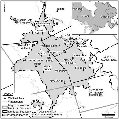
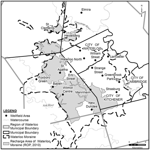
The Regional Municipality of Waterloo (the Region), located in south central Ontario, is comprised of three cities (Kitchener, Waterloo and Cambridge, Figure ) and four surrounding townships (Wilmot, Wellesley, Woolwich and North Dumfries). The Region has a population of about 550,000 and has been identified by the Province of Ontario as a growth area, with a forecast population of 742,000 by 2031 and 835,000 by 2041. Managing the water resources of the Region will be critical during this growth period. The Region currently operates 50 well fields with a total of 126 wells supplying municipal drinking water throughout the Region. These wells provide 80% of the municipal water supply, with the remaining 20% coming from the Grand River. Most of these wells draw their water from the Waterloo Moraine (Figure ), a large, topographically dominant feature that serves as a major groundwater recharge area, which also supports local stream systems and delivers a substantial baseflow to the Grand River. Protecting the groundwater resources of the Waterloo Moraine is critical to the long-term economic and ecologic well-being of the Region.
Figure 1. Location of the Waterloo Moraine and well fields within the Waterloo Moraine.
Understanding where water recharges the aquifer system, how the groundwater moves through the subsurface and where it discharges back to the surface is a critical first step in developing policies to protect municipal drinking water sources. The next step is to take the science and translate it into policy upon which land-use decisions can be made. The challenge is how to take the existing hydrogeological information, and the inherent uncertainty in scientific interpretation, and translate this information into a defensible policy and legal framework, where black-and-white decisions typically prevail.
For surface water, delineating areas requiring protection can be relatively easy as boundaries are typically based on defined physical features (e.g. the subwatershed, floodplain, valleyland or wetland). The groundwater system is below ground surface and typically requires substantial and expensive data collection to establish flow conditions and aquifer systems. Accordingly, one could establish policies at an aquifer scale in which the protection area would be established by the limits of the aquifer. One could also establish policies at a municipal water intake scale. For the latter, this area is traditionally defined using a well capture zone or wellhead protection area (WHPA) approach where zones, typically based on the time it takes water to travel through an aquifer to the well, are determined through the development and use of a groundwater flow model. Each approach has a different scientific basis for developing policy, policy purpose and various challenges when it comes to implementing and defending policy.
The WHPA approach has been utilized to establish water-contributing areas to wells in North America for over two decades. While the delineation method is scientifically acceptable, the development and implementation of policy needs to consider the scientific defensibility and inherent uncertainty to avoid over interpreting the extent to which the science supports the policy. Some of the considerations include the following:
the level of data collection and type of data required to provide a reasonable representation of a specific hydrogeological setting,
the types of models and weighting approach applied to different modelling results,
determination of and setting of policy objectives,
the defensibility of specific policies,
the scale of land-use decisions relative to the scale of the data collection and model area, and
approaches to incorporate new scientific information, as it becomes available, for refinement of WHPAs.
These factors were used in the development of land-use policies and risk-management programs for municipal supply wells in the Waterloo Moraine. The evolution of planning policies to protect groundwater resources in the Region of Waterloo is presented in the first part of this paper. The latter part of the paper explores the many factors that should be considered in developing groundwater protection policies and translating scientific data, with its inherent uncertainties, into a transparent and defensible policy framework.
Background
Groundwater from the Waterloo Moraine has been used for municipal water supply purposes since 1899 with the first wells constructed at the Greenbrook well field in the former Berlin, Ontario (now the City of Kitchener). Historically, groundwater investigations were conducted independently by the cities of Kitchener (Kitchener Water Commission) and Waterloo (Waterloo Public Utilities). As part of a province-wide municipal restructuring process in the 1970s, the Regional Municipality of Waterloo was incorporated in 1973, providing an upper-tier municipality for the amalgamation of the cities of Kitchener, Waterloo and Cambridge and the four surrounding townships. The Region inherited responsibility for providing the “bulk” municipal water supply, while the cities and townships maintained responsibility for the distribution system. This position created the impetus and direction for the Region to undertake water resource investigations and protection of municipal water resources through local policy development.
Since its creation, the Region has undertaken water resource investigations to build an understanding of the science to support ongoing expansion of its groundwater supply (International Water Supply Ltd. Citation1973; Hydrology Consultants Limited Citation1985; Regional Municipality of Waterloo Citation2008). In the 1970s, residents in the rural townships west of Kitchener-Waterloo (Figure ) were opposed to further groundwater extraction to supply the growing urban area. An alternative was proposed by the provincial government to explore the possibility of a pipeline to Lake Erie, 65 km south of the Region, which would have required significant expenditures to construct. Partially in response to this pressure, the Region initiated a Master Water Supply study (Dillon Citation1984) to assess various water supply options. These options included: artificial recharge to the large unconfined aquifer in the Waterloo Moraine using Grand River water, induced infiltration of water from the Grand River to adjacent shallow wells through river connected sands and gravels (Gevaert Citation1979), and exploration of new areas of natural groundwater supplies. As was typical for water supply management at the time, the focus of the assessment was on water availability and quantity, with little emphasis on protecting groundwater from potential surface sources of contamination.
In Canada, each province has jurisdiction over its lands and waters, administered through a variety of provincial legislation. In Ontario, the Planning Act is the primary law governing land-use planning. The Planning Act sets out the framework for municipalities to manage growth, through a range of planning tools, such as official plans, zoning bylaws and site plan controls (Province of Ontario Citation1990). The Planning Act allows the Provincial Minister of Municipal Affairs to issue policy statements on land-use matters of provincial interest, known as the Provincial Policy Statement (PPS), first introduced in 1996 and amended in 1997 and updated in 2005 (Ontario Ministry of Municipal Affairs and Housing Citation2005). The PPS provides the basis for addressing provincial interests, including the protection and management of natural resources, as well as the consideration of a variety of associated environmental features such as floodplains, wetlands and woodlands.
There is no expressed provincial interest in the Waterloo Moraine, or in moraines in general, as natural heritage features. The province’s only expression of provincial interest in moraines was articulated with the enactment of the Oak Ridges Moraine Conservation Act, 2001. The Oak Ridges Moraine, located north of Toronto, Ontario, has been studied since the early 1980s, when development pressures were occurring on this important landform, throughout five upper-tier municipalities, each with differing land-use policies for development on the Oak Ridges Moraine. For Waterloo Region, the Region essentially created natural heritage protection on the Waterloo Moraine without the guidance of provincial policies and without the assurance of overriding provincial interest. The following section provides an overview of the emergence of groundwater protection for the Waterloo Moraine groundwater resource and throughout the Region of Waterloo.
The emergence of groundwater protection for the Region of Waterloo
The 1976 Regional Official Plan Policies (ROPP) has been updated over the years (Regional Municipality of Waterloo Citation1976, Citation1986, Citation1995, Citation2006, and Citation2010), as required by regulations under the Planning Act. Protection of groundwater resources has evolved with each update, through improved understanding of the importance of the resource, adherence to updated provincial policies and as a result of specific groundwater contamination events, locally or provincially, that created catalysts for increased resource protection.
In late 1989, the Ontario Ministry of the Environment (MOE) detected nitrosodemethylamine (NDMA), an organic chemical, during routine water quality testing of several municipal water supply wells in Elmira, Ontario, just north of the City of Waterloo (CH2M Hill Engineering Ltd. Citation1991). The municipal wells were shut down and, at significant cost, an alternative water supply was provided to Elmira through a new 10-km water main constructed to bring water from the City of Waterloo. This sudden impact to the municipal water supply system created increased concern over the vulnerability of all regional municipal water supply wells. In 1991, the Region undertook a number of initial steps to protect all Regional water supply wells, through the development of a comprehensive strategy for protection of water resources. The strategy included consideration of groundwater protection initiatives, in particular wellhead protection programs, which were being implemented throughout the United States under the 1986 Amendments to the Safe Drinking Water Act (US Environmental Protection Agency Citation1989). Researchers at the University of Waterloo’s Centre for Groundwater Research also provided input.
A comprehensive Water Resources Protection Strategy (WRPS) Implementation Plan was approved by the Region in 1994 (Regional Municipality of Waterloo Citation1994) that established a 10-year program for groundwater and surface water investigation and management activities. The objectives of the plan were to limit the risk to water resources from historical and existing land-use practices, as well as from future land uses. The WRPS had two major foci:
to refine the hydrogeology and increase the understanding of the hydraulic connections between the recharge areas, underlying aquifers and water being captured by individual well fields (i.e. to understand the science), and
to develop and implement policies and programs to manage land uses and activities in the geographic areas that contribute water to the municipal well fields.
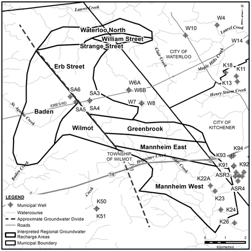
The first major scientific study, initiated in 1991 while the WRPS Implementation Plan was being developed, was the Study of the Hydrogeology of the Waterloo Moraine (Terraqua Investigations Ltd. Citation1995). The Waterloo Moraine was known to be a major contributor of recharge to the groundwater system, but there was a limited understanding of the hydraulic connections between the recharge areas and individual municipal well fields. The main objectives of the study were to delineate major aquifer and aquitard units; define regional recharge areas, estimate well field capture zones and estimate impacts on groundwater levels from municipal pumping. The study significantly improved the understanding of regional groundwater flow throughout the Waterloo Moraine, the first step needed for informed land-use policy decisions. The Terraqua study defined four major aquifers and aquitards throughout the area of the Waterloo Moraine, including a 100-m-thick unconfined sand/gravel core area where major recharge could occur. It also provided an initial interpretation of the regional recharge area and the geographic areas contributing recharge water to individual well fields in the Waterloo Moraine (Figure ). The understanding of the geology and hydrogeology of the Waterloo Moraine has evolved over time and details are found in Bajc et al. (Citation2014, this issue) and Blackport et al. (Citation2014, this issue).
Figure 2. Initial interpretation of regional recharge areas for individual well fields (modified from Terraqua Investigations Ltd. Citation1995).
An ecosystem approach: The Laurel Creek Watershed study
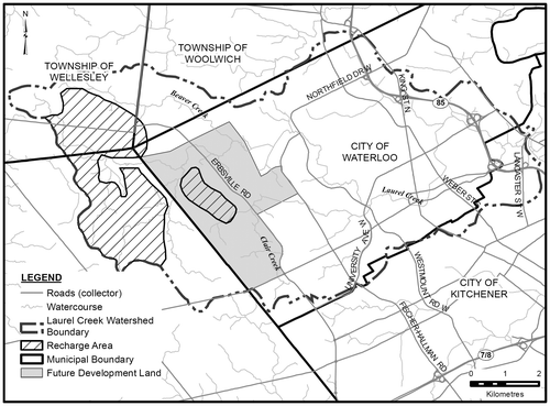
At the same time as the WRPS Implementation Plan was being developed, there were several large land-use development proposals on the west side of the City of Waterloo, within the Laurel Creek Watershed (Figure ). In part to address land-use planning and development issues, a comprehensive environmental study, the Laurel Creek Watershed Study (LCWS), was initiated in 1991 through the efforts of the Grand River Conservation Authority (GRCA), as a co-operative project in partnership with the City of Waterloo, the Region, surrounding townships, the provincial Ministry of Natural Resources and the Ministry of Environment and Energy (Grand River Conservation Authority Citation1993). It was the first watershed study in the province to take an ecosystem approach to planning and development, and was part of a requirement of an Ontario Municipal Board (OMB) decision regarding the development of these lands. The LCWS determined existing environmental and water resource processes, identified potential impacts of land-use changes and developed a planning strategy to manage environmental constraints and water resources on a watershed-wide basis (Flaherty Citation1995).
Figure 3. Location of the Laurel Creek Watershed and City of Waterloo west side development areas on the Waterloo Moraine.
The hydrogeological component of the LCWS identified recharge areas and major discharge areas throughout the watershed. A key recommendation of the LCWS was the creation of land-use constraint levels within the watershed. Of significance, “Constraint Level 2” was applied to lands serving an important ecosystem function that provided specific benefits to the watershed. This included mapped groundwater recharge areas and potential groundwater recharge areas (i.e. areas assumed to be recharge areas but not yet verified through detailed studies), both of which were defined as being crucial to the maintenance of stream flows, fisheries habitat, wetland health, aquifer replenishment and the protection of water quality. The protection of these recharge areas was the first application in Ontario where scientific groundwater information was directly applied to decision-making linked to land-use planning policy. These areas were subsequently designated, and policies consistent with the LCWS were included in the City of Waterloo Official Plan.
Subsequent to the completion of the LCWS, the Region, the GRCA and local municipalities partnered to conduct other watershed and subwatershed studies throughout much of the Waterloo Moraine, where urban development was extending west in Kitchener and Waterloo onto the eastern flank of the core area of the Waterloo Moraine, toward the regional recharge area (Figure ). These studies evolved from typical subwatershed drainage and flood-control design studies to much more comprehensive studies that integrated groundwater recharge and discharge areas with aquatic habitat, fisheries and wetlands in order to provide scientifically defensible data for input into surface and groundwater-related land-use planning decisions (Regional Municipality of Waterloo Citation2005).
Evolution of groundwater protection as official policy
A new ROPP was implemented by the Region in 1995 and took into account much of the new scientific information obtained from the Terraqua study, the LCWS and the other subwatershed studies conducted throughout the headwater creeks in the Waterloo Moraine. The 1995 ROPP established a Natural Habitat Network throughout the Region, which incorporated a wide range of features such as Provincially Significant Wetlands, significant valleylands, and woodlands and fish habitat, and also included sensitive groundwater recharge areas and discharge areas. In the 1995 ROPP, the Region recognized the need to develop groundwater protection policies, and commenced a series of initiatives to have new protection policies included in the 2000 ROPP update.
Concurrent with the timing of the ROPP update, changes to the process of municipal land-use planning in Ontario were undertaken in the early 1990s, through the development of a new set of policy statements establishing a provincial interest in a number of planning issues, including groundwater and surface water. This culminated in the Provincial Policy Statement (PPS) in 1996, which was subsequently amended in 1997. The policy regarding water stated: “the quality and quantity of groundwater and surface water and the function of sensitive groundwater recharge/discharge areas, aquifers and headwaters will be protected or enhanced” (Ontario Ministry of Municipal Affairs and Housing Citation1996, Section 2.4.1). The Planning Act, amended after the 1996 PPS, stated that planning authorities must “have regard to” policy statements in the PPS, in guiding planning decisions, which produced a range of interpretation as to the strength of PPS in the protection of natural heritage features.
Notwithstanding the implementation of the PPS, in 1996, the Region proceeded with the initiation of a program to protect its water resources. In support of this direction and through the implementation of a Water Resources Protection Strategy (WRPS), Region water resources staff proposed that groundwater protection areas be delineated to protect the quality of municipal groundwater supplies (Regional Municipality of Waterloo Citation1996). To adequately protect the existing municipal supply system, the Region moved to protect both the wellhead area and the aquifer supplying water to the well field. The implementation of a wellhead protection program would focus on protecting or improving well water quality, whereas the regional aquifer recharge area protection program would ensure that water quality and quantity throughout the aquifer system would not be compromised. In November 1998, the Regional Council endorsed the concept of Sensitive Groundwater Area designations to be included in the update of the ROPP in 2000.
Development of wellhead protection area policies
With the adoption of Official Plan Amendment Number 12 in 2000, the Region took a major step in recognizing the importance of protecting the water resources of the Waterloo Moraine. Primarily, this amendment called for the ROPP “to direct new non-residential development to areas of the Region where the associated business activities have limited potential to impact groundwater resources used for municipal water supply” (Regional Municipality of Waterloo Citation2000). The amendment proposed policies for protection areas based on a sensitivity ranking, reflecting:
the length of time for groundwater to travel through the aquifer to the well,
the vulnerability of the groundwater to contamination,
the consequences of a contamination event at an individual well or well field, on the water supply system, and
potential groundwater contamination hazards associated with various land-use activities.
Wellhead Protection Sensitivity Areas (WPSAs) were to be identified to provide municipalities with an opportunity to proactively locate new non-residential land uses in areas where their future activities would be unlikely to affect municipal water supplies. The statutory basis for this amendment came from the PPS; however, these amendments provided more robust policies with specific measures to protect groundwater and water supplies.
In support of the planning policies that were being developed and implemented in the mid-1990s through to 2000, there was also additional technical work being undertaken following on the 1995 Terraqua Report. A key component needed to effectively implement the groundwater protection policies was the delineation of WHPAs of the municipal wells, which required the development of a robust groundwater flow model. The advances in the understanding of the hydrogeology from the Waterloo Moraine study, and other studies completed for the WRPS, formed the basis for the groundwater flow modelling work by Martin and Frind (Martin Citation1994; Martin and Frind Citation1998). A study was subsequently commissioned by the Region (Waterloo Hydrogeologic Inc. Citation2000) to provide technically defensible capture zones for the Region’s 16 municipal well fields within the geographic boundary of the Waterloo Moraine. These capture zones were used to develop groundwater protection zones based on time of travel (ToT) of groundwater in the aquifer to a municipal well. A complete discussion of early and recent groundwater flow modelling work and development of WHPAs is found in Frind et al. (Citation2014, this issue) and Meyer et al. (Citation2014, this issue).
The incorporation of the modelled capture zones into the Official Plan represented the first instance in Ontario where science-based WHPAs were brought into the planning sphere. The policies were applied to those situations where redesignation to non-residential development within WHPAs was requested, through either the Region or the local municipalities (Regional Municipality of Waterloo Citation2000). The approach taken to protect the water resource built on the Region’s previous Elmira water supply contamination experience, reflecting the notion that municipalities needed to play a lead role in protecting their water sources through land-use management in sensitive areas.
Delineation of capture zones under uncertainty and the development of groundwater protection zones
In the absence of a provincial framework for source water protection at the time of preparation of the 2000 ROPP, the onus was on the Region to develop scientifically defensible capture zones for WHPA delineations for inclusion in the ROPP, and to ensure that the new policies could withstand potential challenges through the legal appeal system of the Planning Act. To address the inherent uncertainty in groundwater flow modelling and the delineation of capture zones, scenario analysis with a number of possible scenarios was used.
The key model for the scenario analysis was the Waterloo Moraine model (see review by Frind et al. Citation2014, this issue), which is based on the WATFLOW code (Molson et al. Citation1995). To create different scenarios, two different datasets and discretization schemes (13 layers vs. 30 layers, different recharge rates) were used and the model was calibrated for each scenario. For delineation of the capture zones, two approaches were used: backward particle tracking using WATRAC (Frind and Molson Citation2004) and the capture probability approach running a standard transport model in backward mode (Frind et al. Citation2002). The results were expressed as capture envelopes for each well field. In addition, one of the well fields was analyzed by CH2M Hill Canada Ltd. and S.S. Papadopoulous & Associates Inc. (Citation2003) using MODFLOW (Harbaugh et al. Citation2000), and another by Waterloo Hydrogeologic Inc. (Citation2000) using FEFLOW (Diersch Citation2006). For all of these simulations, the flow system was assumed to be at steady state.
This work resulted in multiple capture zones for each well field. Professional judgement was then used to assign a relative confidence weighting to each scenario based on the level of calibration and the extent and distribution of high-quality hydrogeological data (e.g. continuous geological core, water level data in multiple aquifers). Based on this weighting, capture zone envelopes for 2-year, 10-year, and steady-state ToT zones were delineated (Figures and ). The travel time relates to travel in the aquifer, and steady-state travel time means that a particle will have reached its ultimate destination (i.e. the point of recharge). These capture zones were projected up to ground surface to provide plan view representations for each well field. The resulting envelopes became the outer area for the groundwater protection areas that were added to the ROPP (Regional Municipality of Waterloo Citation2008).
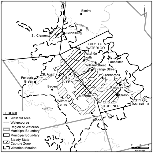
Figure 4. Two- and 10-year well field capture zones within the Waterloo Moraine, September 2000 (adapted from Waterloo Hydrogeologic Inc. Citation2000).
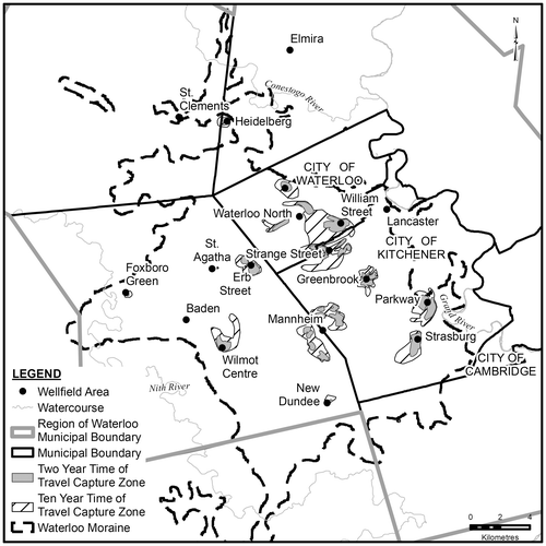
Figure 5. Steady-state well field capture zones within the Waterloo Moraine, September 2000 (adapted from Waterloo Hydrogeologic Inc. Citation2000).
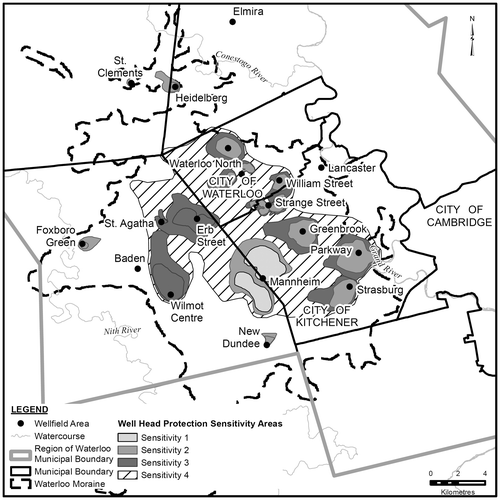
Overlying the capture zone envelopes, a semi-quantitative sensitivity ranking was applied to classify the protection areas based on: (1) the length of ToT through the aquifer to the well (from the capture zone envelopes), (2) the vulnerability to contamination from surface sources, and (3) the severity of the consequences of a contamination incident at a well field to the overall water supply system (Regional Municipality of Waterloo Citation2000). The purpose of these sensitivity designations was to facilitate a tiered protection scheme with more stringent land-use controls to be applied closer to the well (e.g. the 2-year capture zone), or where wells were most vulnerable to surface contamination and the risk of impact to the available water supply system is greater. Figure shows the Wellhead Protection Sensitivity Areas for all municipal wells in the Region, with the most sensitive designation being Sensitivity 1.
Figure 6. Wellhead Protection Areas designated in the Regional Official Policies Plan (ROPP) Amendment 12, November 2000 (adapted from Regional Municipality of Waterloo Citation2000).
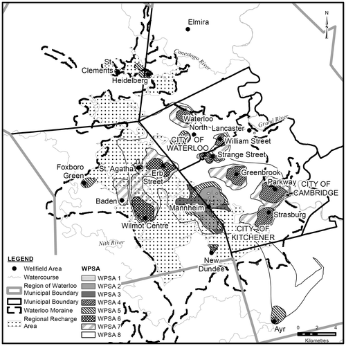
The four WHPAs remained unchanged until the 2010 Regional Official Plan (ROP) (Regional Municipality of Waterloo Citation2010), where eight WPSAs were designated. This was done to account for the different levels of vulnerability arising from different water quality threats, coupled with the level of risk associated with the importance of the well to the Regional water supply system. Figure shows the current designated source water protection areas, which encompass much of the Waterloo Moraine area. These Sensitivity Areas start with the most sensitive, a 100-m radius around the well (WPSA1) for microbial and Dense Non-Aqueous Phase Liquid (DNAPL) control, to land areas outside the 10-year ToT (see WPSA8 in Figure ).
Figure 7. Designated source water protection areas, 2010 Regional Official Plan (ROP; adapted from Regional Municipality of Waterloo, Citation2010). WPSA1 is the most sensitive (100-m radius around the well) and WPSA8 is the least sensitive (areas outside the 10-year time of travel).
Evolution of regional recharge area policy
Another key component of groundwater protection has been the incorporation of a Regional Recharge Area (RRA) into official policies. The RRA plays an important function in providing water to the Region’s drinking water supply and maintaining baseflow to local headwater streams as well as the Grand and Nith Rivers (see Blackport et al. Citation2014, this issue). As with WHPAs, the technical approach to the delineation of the RRA has evolved over time as the scientific understanding has increased. The preliminary interpretation of the RRA was presented in the 1995 Terraqua report and was delineated at that time based on interpreted regional groundwater flow paths, surficial geology and interpreted local areas of recharge within the capture zones of well fields in the Waterloo Moraine.
The RRA designation was first raised as part of a 1996 Groundwater Protection Areas Policy Discussion Paper (Regional Municipality of Waterloo Citation2000), which identified the need to protect the groundwater resource on a broader scale than individual WHPAs. As part of the process to amend the 1995 ROPP in 2000 (the five-year review of the ROPP), it was proposed to include the designation of a Significant Aquifer Recharge Area, and associated policies, into the updated ROPP. The RRA was not designated at the time, partly due to the fact that the majority of the RRA was in the rural area and no groundwater-related land-use controls for non-residential development were proposed in the 2000 ROPP.
The policy discussion paper indicated that the identification of regional recharge areas should not be tied to the capture areas of wells but to entire recharge areas (i.e. regional aquifers), given the need to manage long-term cumulative impacts from non-point sources of contamination (e.g. nitrate loading from agriculture). The policy discussion paper also recommended that potential medium- and large-scale generators of potential contaminants be prohibited from aquifer recharge areas in the future.
An update on the 1996 policy discussion paper was provided to Regional Council in November 1998 (Regional Municipality of Waterloo Citation2000), identifying a regional aquifer recharge area described as an area where
rain water infiltrating directly to the aquifer within this area contributes water to several existing municipal wells, private wells, contributes water to baseflow of several creeks and streams and potentially provides future sources of water to new municipal supply wells. (Regional Municipality of Waterloo Citation1998, 5)
The report recommended that the principal land-use management approach for the RRA be voluntary compliance, awareness and education, as compared to the more restrictive risk avoidance and risk management measures proposed for WHPAs located primarily in the urban area. Although the Region proposed the idea of regulating certain types of land uses within the RRA in 1996, the RRA was not introduced into the planning sphere until the 2010 update of the ROP. The RRA was not officially designated until the 2010 ROP, as the Region felt that since much of the RRA is located within a designated Agricultural Resource Area it would be protected from encroachment of urban development (Regional Municipality of Waterloo Citation2005). In addition, all of the regional recharge areas located within the city’s urban areas generally overlapped with the wellhead protection areas and had a high level of protection.
Delineation of the regional recharge area
Subsequent to the Terraqua Citation1995 delineation of recharge areas to the well fields, the delineation of the RRA was refined in 1996, 2003 and 2009. Regional thinking evolved to consider both the recharge area directly contributing to the underlying aquifer and surface drainage areas connected to the recharge area as being part of the RRA. Three criteria were considered to refine and update the RRA: (1) where permeable geologic materials exist at or near ground surface, (2) where less than 2 m of lower permeable geologic materials overlie these aquifers, and (3) the land area adjacent to these areas which drain surface runoff to the aquifer recharge area (Regional Municipality of Waterloo Citation1996).
Since 1996, there have been improvements in technology to refine physical information collected in the field, including digital elevation models (DEM), geographic information systems (GIS), and geographic positioning systems (GPS). A more comprehensive analysis to further refine and update the RRA was conducted in 2003 using updated hydrogeological and geospatial information. This update included combining surficial geology information from Ontario Geological Survey (OGS) GIS mapping and using revised DEMs. The revised DEMs were used to identify closed depressions and refine subwatershed boundaries, local drainage features and streambed elevations. All of this information was used to define areas of contribution to the RRA, for inclusion into the RRA. Figure shows the delineation of the updated 2003 RRA (Regional Municipality of Waterloo Citation2003).
Figure 8. Delineation of the regional recharge area for the Waterloo Moraine, 2003 (adapted from Regional Municipality of Waterloo Citation2003).
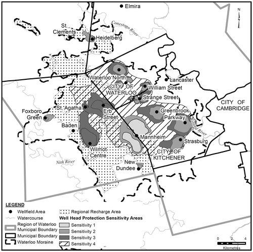
Since 2003, the RRA boundary has been further refined using updated information from new OGS mapping (Bajc and Shirota Citation2007) and groundwater modelling of the municipal well field in Ayr as part of the Cedar Creek Watershed study (Water and Earth Science Associates Ltd. Citation2005), located in the southern portion of the Waterloo Moraine. In addition, the eastern boundary of the RRA in southwest Kitchener was modified to reflect additional information obtained from development applications submitted under the Planning Act, received by the Region since 2000. The latest mapping of the RRA is included in the 2010 ROP (Figure ).
Figure 9. Delineation of the regional recharge area for the Waterloo Moraine, 2010 (adapted from Regional Municipality of Waterloo Citation2010).
Integrating environmental protection and source water protection on the Waterloo Moraine
Since 1976, the Region has utilized planning policy authority to protect the integrity of natural heritage features and functions. Although the Waterloo Moraine is not a recognized natural heritage feature in planning policy, the Region has approached protection and conservation on the Waterloo Moraine by focussing on natural heritage features, first as “islands of green” then progressing to a “Greenlands Network”. The Greenlands Network is defined as environmental features and linkages among these features. The 2010 ROP takes a layered approach to environmental protection, using Landscape Level Systems, Core Environmental Features and Supporting Environmental Features (Regional Municipality of Waterloo Citation2010). Landscape Level Systems include Environmentally Sensitive Landscapes and Regional Recharge Areas. Within the ROP, the Moraine is considered to represent a Landscape-Level System which reflects either a single large-scale environmental feature or a significant concentration of smaller environmental features. Much of the Waterloo Moraine is within these landscapes, located in rural countryside areas. The part of the RRA that represents the Laurel Creek headwaters in northwest Waterloo is now designated as an Environmentally Sensitive Landscape.
In the 2010 ROP, the Waterloo Moraine is given some meaning in policy. The planning policies designated a “Protected Countryside” which surrounds the designated Urban Area and is intended to provide permanent protection from land-use changes (e.g. urban development). The Protected Countryside designation identifies a continuous band of environmental features and agricultural lands surrounding the north, west and south side of the Urban Area. The Protected Countryside includes much of the RRA in the Waterloo Moraine and is intended to permanently protect these areas from urban development. The 2010 ROP now integrates environmental protection with groundwater water protection on the Waterloo Moraine and represents the Region’s first attempt to officially consider, within a planning context, to protect the ecological integrity for much of the Waterloo Moraine.
The emergence of provincial source water protection policy
In 2000, a municipal well in Walkerton, Ontario, northwest of the Region of Waterloo, was discovered to be contaminated with E. coli bacteria resulting in the death of seven people and many more having long-term illnesses. This water-related disaster led to the Walkerton Inquiry, which resulted in a defining report (O’Connor Citation2002), providing Ontario with a series of source water protection-related recommendations. The report proposed a watershed-based approach to source water protection (Province of Ontario Citation2004) which led to the promulgation of the Clean Water Act (Province of Ontario Citation2006) to protect the quality and quantity of municipal water sources.
Until this time, the Region had tailored groundwater protection to meet its unique Canadian situation, that being a large land-locked urban municipality primarily dependent on groundwater for municipal supplies. Prior to Walkerton, the Region’s protection strategy was developed in the absence of any provincial framework that could provide structure and enforceability, and “level the playing field” with other municipalities from an economic, planning and land-use perspective, by having to include similar environmental protection measures for drinking water. The Region’s WRPS focused on increasing the understanding of the groundwater resources, as well as moving forward with realistic policies that could contribute to protection of municipal groundwater supplies. The Clean Water Act introduced new technical assessment requirements and new implementation tools beyond the Planning Act, which was the primary regulatory tool the Region used for source water protection.
The Clean Water Act (CWA) of 2006 provides a framework to develop local source water protection plans. The Act requires local source water protection authorities to work with municipalities to assess their water supplies for both water quantity (water budget and water quantity risk assessment) and water quality (vulnerable area delineation, threat identification and water quality risk assessment). Water budget and water quantity risk assessments were conducted at the watershed and subwatershed scale while water quality assessments were conducted at the wellhead capture area scale. Guidance modules were prepared by the MOE to aid in assessing the vulnerability of groundwater to contamination and to assess water budget and water quantity risks (Ontario Ministry of the Environment Citation2006, Citation2007). Methodologies were also developed to conduct contaminant threats inventories and evaluate drinking water quality issues at all water supply intakes. The methodologies were replaced with a set of technical rules, which are required by CWA legislation (Province of Ontario Citation2009).
The CWA identifies three types of vulnerable areas related to drinking water sources from groundwater:
highly vulnerable aquifer areas,
significant groundwater recharge areas, and
wellhead protection areas.
As part of the vulnerability assessment, WHPAs were to be delineated for different ToT zones for individual well fields and these zones would be tied to risk management zones, namely:
WHPA-A, a100-m pathogen security zone,
WHPA-B, a two-year ToT pathogen protection zone;
a five-year ToT dense non-aqueous liquid (DNAPL) protection zone, and
a five-year and 25-year chemical protection zone.
To take advantage of this new provincial interest, the Region received funding from the Ontario Ministry of the Environment (MOE) to conduct a number of technical studies to align with the MOE’s source water protection approach, which included an update to the WRPS Master Plan in order to incorporate the requirements of the CWA and to guide source water protection activities for the Region from 2007 through to 2016 (Regional Municipality of Waterloo Citation2008). The Master Plan was implemented in two phases. The first phase was to address activities and programs in the interim period until 2012, prior to the completion of the Source Protection Plan for the Region, as required by the CWA. This phase focused on improving the understanding of groundwater flow to each well field, with an emphasis on the well fields where water quality had been impacted by historical and/or existing land uses. The second phase would start after the integration of the Master Plan with the Source Protection Plan and would focus on risk reduction and risk management, guided by the completed Source Protection Plan. This would include the updates to existing numerical groundwater flow models that have been completed by the Region (see Meyer et al. Citation2014, this issue) to align with the requirements of the Technical Rules of the CWA.
The CWA Technical Rules require that water quantity and water budget assessments be completed for each watershed in the Province. A provincial MOE guidance document (Ontario Ministry of the Environment Citation2007) was developed, taking a three-tiered approach, where each tier used more sophisticated analysis tools and analysis completed at a progressively smaller scale. A water quantity risk assessment was carried out at a subwatershed scale by calculating the percentage of water used for municipal water supply purposes, compared to the total amount of water available within each subwatershed. In the Grand River watershed, extensive data sets collected by the Region, the local municipalities and the Grand River Conservation Authority were used to conduct the water quantity assessment at the “second” tier, calculating the water quantity stress through the use of hydrological and hydrogeological models at the watershed scale. Results of this water budget modelling (AquaResource Inc. Citation2009) indicated that several subwatersheds, encompassing much of the Waterloo Moraine, had a high water use requiring a more detailed well-by-well assessment of the Region’s ability to meet future water demands from groundwater. Information from the water budget model for the Grand River watershed was incorporated into an updated hydrogeological model of the Waterloo Moraine, which was then used to undertake the third-tier local water budget and risk assessment, ongoing as of the date of submission of this paper.
The source protection studies have resulted in considerable advances to the understanding of the Waterloo Moraine area through updates and refinements to the hydrological and hydrogeological models at the watershed scale. Watershed and subwatershed water budget analyses were required at a broader scale while the capture zones for each well field were refined at the local scale.
The challenge: Developing science-based policy in the face of uncertainty
The Region of Waterloo has been developing water resource protection programs for over 20 years with a major focus on the water resources of the Waterloo Moraine. As the science and understanding of the hydrogeology of the Waterloo Moraine have evolved, the protection strategies and policies have also evolved. The continuing challenge for the Region, and indeed across Ontario, has been in taking the ever-changing science, with all of its inherent uncertainties, and translating it into a policy and legal framework upon which effective land-use decisions can be made.
The Region’s current land-use policies dealing with source water protection focus primarily on issues related to water quality and within areas of greater aquifer vulnerability, with specific policies tied to specific types of protection zones (e.g. local wellheads or larger recharge areas). With the introduction of the CWA in 2006, there is now also a focus on local-scale water budget assessments, with these policies addressing both the sustainability of water-taking at individual well fields and the sustainability of the water resource as a whole. Both types of policies (quality-related and quantity-related) have been developed based on the use of numerical groundwater models. Both types of policies have different challenges when it comes to their implementation and defense. The following sections highlight the various considerations, related to scientific uncertainty and defensibility, when interpreting the extent to which the underlying science is used to support land-use planning policies for source water protection.
Setting a policy framework
The aim of all policy objectives is to manage existing and future threats to water resources. As threats come in many different forms, the policy framework must be nuanced to account for these different types of threats. For example, point source contamination (e.g. chemical spills) and non-point source contamination (road salt) require a different policy framework to address each issue due to a number of factors including: the nature of the threat, whether the threat creates a chronic or acute risk and which implementation tools are most appropriate to address the threat. The former (point source contamination) requires a ToT (in the aquifer) approach and more stringent protection policies, while the latter (non-point source contamination) may work with a less stringent approach (e.g. education and awareness) for implementing risk reduction across a broader geographic area.
For point sources of contamination from a chemical spill or discharge near a well, the shorter the travel time to the well, the greater the threat because there will be less time to react to avert an immediate impact to the water supply system. These greater risks create the need for more stringent planning policies closer to the well.
Non-point source contamination, such as nitrate from agricultural practices or septic systems, represents a potential long-term risk to a large area of an aquifer system, especially if occurring within a recharge area. The impact of such broadly based contamination occurs slowly over long time periods and does not result in sudden changes in well water quality. The policies to address these risks do not require immediate action. From a practical perspective, the geographic area that contributes non-point source contamination to the groundwater may be large, and the risk to the supply well could build slowly in a more chronic manner. Such threats are best addressed through Beneficial Management Practices (BMPs), combined with education, financial incentives, or other non-regulatory approaches. BMPs are discussed by Sousa et al. (Citation2014, this issue), Sousa et al. (Citation2013) and others.
The Planning Act regulates land uses (e.g. manufacturing) but not activities within land use (e.g. chemical handling and storage) within broad land-use categories. With the CWA, municipalities are required to develop Risk Management Plans, which will provide a mechanism to regulate specific activities considered threats in sensitive and vulnerable source water areas, through the use of risk categories. Different levels of protection-related policies are applied to areas with different levels of aquifer vulnerability, thus providing a more defensible set of land-use planning policies.
Capture zone delineation and choosing WHPA boundaries
The WHPA approach to creating distinct groundwater protection zones has been utilized throughout North America for over two decades. While the approach is scientifically acceptable, it evolves over time, which creates challenges when developing and implementing municipal land-use planning policies related to these areas.
Howard and Gerber (Citation1999) argued that the typical wellhead protection classifications tend to be only effective in geologically simple settings, where groundwater flow systems can be clearly and confidently defined. For example, Dayton, Ohio, which was one of the first cities in North America to develop wellhead protection zones, is located over a shallow unconfined municipal water supply aquifer that is highly vulnerable to overlying surface source contamination. Wellhead protection areas can be defined with reasonable accuracy in this setting given the simplicity of the groundwater flow system and recharge area. Many researchers have shown the variability in groundwater flow models, due to hydrogeological parameter uncertainty (e.g. Evers and Learner Citation1998; Martin and Frind Citation1998).
The primary method to delineate WHPAs for complex groundwater systems is through the use of numerical groundwater flow models. As indicated previously, numerical model results, particularly those related to WHPA delineation, are inherently uncertain to some extent due to uncertainties in the hydrogeological parameters. Uncertainty exists at two scales, where the larger aquifer system scale includes the conceptual model, the geologic layer construction, the continuity of individual layers and the model boundary conditions, while the smaller local scale expresses the unknown variability in hydraulic conductivity within the layers. All these uncertainties influence groundwater flow patterns and velocities, as well as contaminant migration through the aquifer to the well. The large-scale uncertainties have been found to be the most important (Sousa et al. Citation2013). These uncertainties can be incorporated into a numerical groundwater model by using scenario analysis (Sousa et al. Citation2013) or varying the controlling parameters within certain ranges (Meyer et al. Citation2014, this issue) to create WHPA envelopes, but the challenge is incorporating these uncertainties into acceptable and defensible land-use policies. The more complex the geological and hydrogeological setting the greater the uncertainty and the greater the data collection required to minimize the uncertainty.
To more effectively address this inherent uncertainty, the Region’s approach to creating WHPAs, prior to the Provincial Source Water Protection program, evolved to include creating capture zone envelopes for the WHPAs. In addition to the WHPA delineation, the Region developed a semi-quantitative indexing method to classify WHPAs into “sensitivity categories” (Wellhead Protection Sensitivity Areas or WPSAs), to include the degree of importance of a well or well field to the overall Regional water supply strategy. Sensitivity ratings were scored high for well fields that provide greater volumes of water to the municipal water system or that have no redundant water supply (i.e. rural well fields not connected to the integrated urban water supply system) and were reduced at some well fields where sufficient hydrogeological information was available to confidently conclude there was a greater degree of protection and where the existing land-use activities posed a lower risk. The sensitivity rating was directed primarily at addressing threats from point source contamination within the 10-year ToT zone of the WHPA.
In developing the current WHPAs, the Region used multiple lines of evidence to provide a higher level of confidence, including: well field-specific studies (i.e. well field shutdowns and long-term pumping tests to show the degree of hydraulic connection between the pumped aquifer and other aquifers or surface water), long-term water level monitoring records, water quality data (e.g. trends in nitrate or chloride concentrations or the presence of water quality parameters of concern linked to a specific contaminant source area), isotope data to age date water within the aquifer system and at pumping wells, steady-state and transient calibration of groundwater flow models, and incorporation of local-scale uncertainty of hydrogeological parameters into fully calibrated flow models (e.g. Frind et al. Citation2002; Meyer et al. Citation2014, this issue).
The need for flexibility in groundwater-related policies
Groundwater protection areas differ from other types of environmental constraint areas in that they are not observable on the landscape. For example, it is relatively straightforward to incorporate wetland areas into the existing Official Plan, since there are specific provincially agreed-upon criteria available with which to identify and classify Provincially Significant Wetlands (PSWs). Previously unevaluated wetlands can have criteria applied, making them eligible for protection in the context of development applications and for recognition in land-use plans (i.e. the legislative rules and policies are enforced indirectly through the Provincial Policy Statement 2005). However, since groundwater flow and ToT in an aquifer cannot be similarly “ground-truthed”, policy makers must have the means to evaluate the credibility and defensibility of model-derived protection zones, as well as that of the underlying science.
The defensibility test for a source water protection policy is different than that of the underlying science upon which a policy might be developed. Whereas the science-based assessment recognizes uncertainty, policies require greater certainty to establish planning zones where specific policies will apply (e.g. policies require a “line on a map” for effective implementation). A WHPA is an example where uncertainty in the science must be factored into the delineation in order to create a “hard line” on the land-use plan.
Land-use and development decisions are typically made at the individual land parcel scale, whereas the science that underpins groundwater-related policies, used to delineate the protection areas, is typically based on a more regional-scale interpretation and might have limited, or even no, scientific information (e.g. geological or hydrogeological data) on an individual land parcel that is within a specific protection area covered under the policy. Information is often collected at this local scale, as part of a development application, after the regional hydrogeological interpretation has been developed (and perhaps rendered and calibrated in a numerical model). In some instances, planning disputes can arise for individual properties where a property is on one side of a protection area planning line and it is argued that, based on additional site-specific data or disputed interpretation of the existing technical information, the location of the planning line is not appropriate and should be revised, or the policy might not be applicable for the individual property, based on the new scientific information. The policy approach needs to consider how new information obtained from site-specific studies is treated, with respect to the interpretation of the planning line and/or the policy.
As the delineation of wellhead protection zones is necessarily based on numerical groundwater models, the uncertainties inherent in the modelling process (see the preceding section) must be understood. The standard procedure is to calibrate a model (consisting of the conceptual model, boundary conditions and specific dataset) until an acceptable “fit” is obtained. The model is then used for predictive purposes, such as capture zone delineation. Uncertainties can exist at several levels, including the conceptual model itself, the boundary conditions and the parameter values used in the model. It is also possible that different conceptual models or different boundary conditions will give an equally acceptable fit to the same data set; this is known as calibration non-uniqueness (Sousa et al. Citation2013). As new data become available and are incorporated into the dataset, the model changes and a new calibration may become necessary, which could yield different results. It must be recognized that these model updates are periodic and will not always align with the timing of a specific development application being considered for approval. It may be most appropriate to coordinate groundwater model updates with updates to the Official Plan or significant OP amendments. Policy planners, working in cooperation with hydrogeologists, must determine whether the results of a groundwater model update warrant policy revisions (e.g. revisions to WHPA delineations).
Data collection and data gaps
There will always be data gaps and uncertainties in understanding and quantifying natural systems. Numerical models attempt to represent the geological and hydrogeological conditions; however, the conceptualization is still a simplification of the natural system. Data collection should be prioritized based on the following considerations:
complexity of the hydrogeological setting,
importance of the well or well field,
vulnerability of the well or well field, and
current and historical land-use practices.
All data collected should be properly managed in robust databases and continually brought to bear on all groundwater issues and policies. The key is having a good system for capturing all appropriate data and metadata, especially information obtained through development applications. Mechanisms should be developed to ensure all data collected at the local scale (site plan) can be appropriately captured and maintained in a data base that can be easily accessed to ensure all parties (e.g. municipalities, provincial agencies and land developers) are working with the same dataset. Data management within the wider context of “knowledge management” is discussed by Holysh and Gerber (Citation2014, this issue).
Closing the credibility gap: Transparency in reporting
Temporal and spatial characteristics of groundwater systems are dynamic and are subject to uncertainty. The scientific understanding of these natural systems evolves over time, the result of both the collection of additional data and the continuing advances in the science. When establishing planning policies based on science, regulatory agencies at all levels (e.g. municipal, provincial) should be aware of the underlying uncertainty and of the evolution of the understanding of the science over time. This also raises a concern about determining how often it is necessary to re-evaluate the uncertainty of the science and the certainty of the policy.
Uncertainty is ubiquitous and cannot be eliminated, and, if left unexplained, this uncertainty creates a credibility gap. Scientists and policy makers in regulatory agencies can help to close the gap by joining together to make uncertainties more understandable and controllable. As scientists should be aware of the requirements of policy development, policy makers should be aware of the limitations of scientific methods. Unfortunately, modelling uncertainty is sometimes not fully appreciated, as for example when a model calibrated to a dataset is taken to be unconditionally valid for predictive purposes. Awareness of uncertainties requires transparency through detailed discussion of the modelling process, including the conceptual model and the boundary conditions, what alternative conceptual models have been considered, the dataset and the limitations thereof and the calibration. This level of transparency will document the extent to which uncertainty has been addressed, and it will raise the level of understanding, thereby improving the integrity of the planning process.
Conclusions
The primary source of the Region of Waterloo’s water supply is from over 100 municipal wells, many of which are located within the Waterloo Moraine or obtain a portion of their water from water recharging the Waterloo Moraine. The scientific understanding of the Waterloo Moraine has evolved over the last 40 years, primarily to increase the understanding of the hydrological and hydrogeological processes that govern and control groundwater movement throughout the Moraine. The Region has been developing water resource protection policies for over 25 years, with much of the focus on the Waterloo Moraine. Early protection policies were developed in response to groundwater contamination events, and evolved in the absence of broader provincial policies. In 1995, a Water Resources Protection Strategy was implemented with the primary resource protection method being the implementation of Wellhead Protection Areas (WHPAs).
Through Official Plan Policy, the Region has designated the Waterloo Moraine a vital feature, not only for its groundwater importance, but also owing to its natural heritage features and functions. In successive earlier Regional Official Plans (1976, 1985 and 1995), the Region regarded the Waterloo Moraine principally for its natural heritage features and functions starting with an “as islands of ecologically sensitive areas” approach and moving to an “environmentally broader, more encompassing environmental features, covering sensitive landscape” approach. This significant progression of policy was accomplished without provincial government guidance or statutory prescription. In 2000, the Region introduced an amendment to the Regional Official Policies Plan to protect water resources from urban sources of contamination and moved to protect sensitive recharge areas on the Waterloo Moraine. The Clean Water Act, legislated by the Province of Ontario in 2006, further strengthened groundwater protection, for both quality and quantity, through the implementation of source water protection plans. The current Regional Official Plan provides further protection of the Waterloo Moraine through the designation and protection of a Regional Recharge Area, encompassing a broad area of the Waterloo Moraine.
Within the framework of the Region’s Official Plan, and indeed throughout the Province, groundwater-related protection policies must be weighed against appropriate future land-use within areas requiring protection. The challenge has been, and continues to be, the development of appropriate, defensible and adaptable groundwater protection policies, given the inherent uncertainties associated with the subsurface.
The gap between science and policy has closed considerably as a result of the Clean Water Act and extensive work undertaken at the provincial level to address the Technical Rules of the Act, resulting in the development of Source Water Protection Plans at the municipal level. Areas of source water more vulnerable to either water quality or quantity risks now have more stringent Source Water Protection Policies. In the long term, the current model for establishing source water protection areas in Ontario may be successful because it is now mandated under the Clean Water Act and it is undertaken in consideration of watersheds. Ensuring these policies are implemented depends to a large extent upon the capacity (e.g. staff, financial resources and political support) of each municipality responsible for administering the protection policies, and their ability to translate the scientific understanding and policies into credible land-use planning decisions. However the integration is framed, the public forums for defending the science underlying the policy and the policy itself must be clearly established, with a transparent discussion of the uncertainty associated with the science. As the understanding of the science continues to evolve through data collection and use of new technologies, the uncertainty associated with the science needs to be reconciled with the certainty expected of protection policy. Although the uncertainty cannot be eliminated, it needs to be adequately explained in order to minimize the credibility gap and increase the level of transparency in the process.
Numerical groundwater models will continue to be required to provide the most robust understanding of hydrological and hydrogeological processes by incorporating information from individual technical assessments and site-specific information. These models will need to ensure that the predictions reflect the underlying uncertainty in the data. Numerical models can be used to integrate information from different sources, test different scenarios and build on previous experience, and in that way contribute to the development of defensible water resource protection policies. Nowhere in the Region is this more important than in the complex geological and hydrogeological setting of the Waterloo Moraine.
The Region of Waterloo has taken over three decades to go through the evolutionary process of framing an effective planning policy for the water resource of the Waterloo Moraine. Other jurisdictions will have the benefit of building on the Waterloo experience, as well as on the guidance of legislative tools that are now available. On this basis, there should be confidence that important natural features such as the Waterloo Moraine will be protected and will continue to play their vital role as sustainable and dependable water sources into the future.
Acknowledgements
This review has been supported by the Groundwater Geoscience Program, Geological Survey of Canada, Natural Resources Canada. Much of the original scientific information on the Waterloo Moraine referenced in this review was obtained through collaborative efforts over many years between the Regional Municipality of Waterloo, University of Waterloo, the Grand River Conservation Authority, the City of Waterloo and the City of Kitchener through a variety of support from the Region of Waterloo, the Province of Ontario and the Natural Sciences and Engineering Research Council of Canada. The Region of Waterloo provided much of the background and historical information related to Regional planning policies. Matrix Solutions Inc. provided support for the preparation of the figures. The authors would like to thank the Editor and the reviewers, Eric Hodgins, Steve Holysh and Barb Anderson, who provided detailed constructive comments, greatly enhancing the quality of the manuscript.
Disclaimer
It should be noted that any well capture zones, wellhead protection areas, recharge areas or well vulnerability zones shown in this paper are for illustrative purposes only and do not necessarily represent the official source water protection areas of the Regional Municipality of Waterloo. For official designations, please refer to the relevant documentation of the Regional Municipality of Waterloo.
References
- AquaResource Inc. 2009. Grand River Authority tier two water budget stress assessment. Prepared for the Grand River Conservation Authority. Waterloo, ON: AquaResource Inc.
- Bajc, A. F., and J. Shirota. 2007. Three-dimensional mapping of surficial deposits in the Regional Municipality of Waterloo, southwestern Ontario. Sudbury, ON: Ontario Geological Survey Groundwater Resources Study 3.
- Bajc, A. F., H. A. J. Russell, and D. R. Sharpe. 2014. A three-dimensional hydrostratigraphic model of the Waterloo Moraine area, southern Ontario, Canada. Canadian Water Resources Journal 39(2): doi: 10.1080/07011784.2014.914794.
- Blackport, R. J., P. A. Meyer, and P. J. Martin. 2014. Toward an understanding of the Waterloo Moraine hydrogeology. Canadian Water Resources Journal 39(2): doi: 10.1080/07011784.2014.914795.
- CH2M Hill Engineering Ltd. 1991. Elmira-St. Jacobs water supply project, volume 2, Elmira aquifer system: Contaminant plume mapping and source investigation. Report to the Region of Waterloo. Kitchener, ON.
- CH2M Hill Canada Ltd. and S. S. Papadopulos & Associates Inc. 2003. Alder Creek groundwater study final report. Report to the Region of Waterloo. Waterloo, ON.
- Diersch, H.-J. G. 2006. FEFLOW finite element subsurface flow and transport simulation system – reference manual, user’s manual, white papers – release 5.3. Berlin: WASY Institute for Water Resources Planning and Systems Research.
- Dillon, M. M. 1984. Master water supply study of existing groundwater supplies and new short-term supplies for Kitchener-Waterloo. Prepared for The Region of Waterloo. Toronto, ON.
- Evers, S., and D. N. Lerner. 1998. How uncertain is our estimate of a well head protection zone? Groundwater 36(1): 49–57.
- Flaherty, L. 1995. Waterloo’s west side story: Planning for the Laurel Creek Watershed, Case Report No. 4. Waterloo, ON: Department of Environmental and Resource Studies, University of Waterloo.
- Frind, E. O., D. S. Muhammad, and J. W. Molson. 2002. Delineation of three-dimensional capture zones in complex multi-aquifer systems. Ground Water 40(6): 586–589.
- Frind, E. O., and J. W. Molson. 2004. A new particle tracking algorithm for finite element grids. Keynote Lecture presented at the FEM-MODFLOW Conference ( sponsored by International Association of Hydrological Sciences / United States Geological Survey), Carlsbad, Czechia.
- Frind, E. O., J. W. Molson, M. R. Sousa, and P. J. Martin. 2014. Insights from four decades of model development on the Waterloo Moraine: A review. Canadian Water Resources Journal 39(2): doi: 10.1080/07011784.2014.914799.
- Gevaert, D. 1979. Location and evaluation of induced infiltration sites near the Grand River in the Kitchener-Waterloo area. M.Sc. project: Department of Earth Science, University of Waterloo.
- Grand River Conservation Authority. 1993. Laurel Creek Watershed study. Cambridge, ON.
- Harbaugh, A. W., E. R. Banta, M. C. Hill, and M. G. McDonald. 2000. MODFLOW-2000, the US Geological Survey modular ground-water model. User guide to modularization concepts and the ground-water flow process. Open File Report 00-92. Reston, VA: US Geological Survey.
- Holysh, S., and R. Gerber. 2014. Groundwater knowledge management for southern Ontario: An example from the Oak Ridges Moraine. Canadian Water Resources Journal 39(2): doi: 10.1080/07011784.2014.914788.
- Howard, K. W. F., and R. Gerber, 1999. Protection of groundwater in areas threatened by urban development. In Proceedings of the XXIX IAH Congress – Hydrogeology and Land-use Management, 397–402. Bratislava, Slovakia.
- Hydrology Consultants Limited. 1985. The Regional Municipality of Waterloo master water supply study – Activity G – Stage 3, new natural groundwater supplies for Kitchener-Waterloo. Mississauga, ON.
- International Water Supply Ltd. 1973. Kitchener-Waterloo groundwater evaluation. Unpublished report to the Regional Municipality of Waterloo. Barrie, ON.
- Martin, P. J. 1994. Modelling of the north Waterloo multi-aquifer system. M.Sc. thesis, University of Waterloo.
- Martin, P. J., and E. O. Frind. 1998. Modeling a complex multi-aquifer system: The Waterloo Moraine. Groundwater 36(4): 679–690.
- Meyer, P. A., M. Brouwers, and P. J. Martin. 2014. A three-dimensional groundwater flow model of the Waterloo Moraine for water resource management. Canadian Water Resources Journal 39(2): doi: 10.1080/07011784.2014.914800.
- Molson, J. W., P. J. Martin, and E. O. Frind. 1995. WATFLOW Version 1.0: A three-dimensional groundwater flow model, user’s guide. Waterloo, ON: Waterloo Centre for Groundwater Research
- O’Connor, D. 2002. Report to the Walkerton Inquiry, Part 2. Ontario Ministry of the Attorney General. Toronto, ON: Queen's Printer for Ontario.
- Ontario Ministry of the Environment. 2006. Draft guidance module 3. Groundwater vulnerability analysis (draft). Toronto, ON: Queen's Printer for Ontario.
- Ontario Ministry of the Environment. 2007. Draft guidance module 7. Water budget and water quantity risk assessment. Toronto, ON: Queen's Printer for Ontario.
- Ontario Ministry of Municipal Affairs and Housing. 1996. Provincial Policy Statement. Toronto, ON: Queen's Printer for Ontario.
- Ontario Ministry of Municipal Affairs and Housing. 2005. Provincial Policy Statement. Toronto, ON: Queen's Printer for Ontario.
- Province of Ontario. 1990. Planning Act, R.S.O. 1990, c. P. 13, as amended. Toronto, ON: Queen's Printer for Ontario.
- Province of Ontario. 2004. Watershed-based source protection planning: A threats assessment framework. Technical Experts Committee Report to the Ministry of the Environment. Toronto: Queen’s Printer for Ontario.
- Province of Ontario. 2006. Clean Water Act. Toronto, ON: Queen’s Printer for Ontario.
- Province of Ontario. 2009. Technical rules: Assessment report, Clean Water Act, 2006. Toronto: Queen’s Printer for Ontario.
- Regional Municipality of Waterloo. 1976. Regional Official Policies Plan (ROPP). Waterloo, ON: Regional Municipality of Waterloo.
- Regional Municipality of Waterloo. 1986. Regional Official Policies Plan (ROPP). Waterloo, ON: Regional Municipality of Waterloo.
- Regional Municipality of Waterloo. 1994. Water resources protection strategy implementation plan. Waterloo, ON: Regional Municipality of Waterloo.
- Regional Municipality of Waterloo. 1995. Regional Official Policies Plan (ROPP). Waterloo, ON: Regional Municipality of Waterloo.
- Regional Municipality of Waterloo. 1996. Groundwater protection areas policy discussion paper. Waterloo, ON: Regional Municipality of Waterloo.
- Regional Municipality of Waterloo. 1998. Groundwater Protection Area Designations and Policy Update, November 17, 1998. Kitchener, ON: Regional Municipality of Waterloo.
- Regional Municipality of Waterloo. 2000. Regional Official Policies Plan (ROPP), amendment #12. Water resources protection strategy future urban point source. Waterloo, ON: Regional Municipality of Waterloo.
- Regional Municipality of Waterloo. 2003. Background report no. 1: Status assessment of water resources protection strategy – draft. Waterloo, ON: Regional Municipality of Waterloo.
- Regional Municipality of Waterloo. 2005. Environmental considerations shaping the regional growth management strategy. Report by Planning, Housing and Community Services. Waterloo, ON: Regional Municipality of Waterloo.
- Regional Municipality of Waterloo. 2006. Regional Official Policies Plan (ROPP), amended to 30 September 2006. Waterloo, ON: Regional Municipality of Waterloo.
- Regional Municipality of Waterloo. 2008. Water Resources Protection Master Plan. Waterloo, ON: Regional Municipality of Waterloo.
- Regional Municipality of Waterloo. 2010. Regional Official Policies Plan (ROPP). As approved, with modifications, by the Minister of Municipal Affairs and Housing, 22 December 2010. [ Note the ROPP is Before the Ontario Municipal Board at the time of preparation of this publication]. Waterloo, ON: Regional Municipality of Waterloo.
- Sousa, M. R., E. O. Frind, and D. L. Rudolph. 2013. An integrated approach for addressing uncertainty in the delineation of groundwater management areas. Journal of Contaminant Hydrology 148: 12–24.
- Sousa, M. R., D. L. Rudolph, and E. O. Frind. 2014. Threats to groundwater resources in urbanizing watersheds: The Waterloo Moraine and beyond. Canadian Water Resources Journal 39(2): doi: 10.1080/07011784.2014.914801.
- Terraqua Investigations Ltd. 1995. Study of the hydrogeology of the Waterloo Moraine. Unpublished report to the Regional Municipality of Waterloo. Waterloo, ON.
- US Environmental Protection Agency. 1989. Guidelines for delineation of wellhead protection areas. Office of Water, Report WPA 4405-93-001. Washington, DC, USA.
- Water and Earth Science Associates Ltd. 2005. Cedar Creek hydrogeological investigation. Prepared for the Region of Waterloo. Kitchener, ON.
- Waterloo Hydrogeologic Inc. 2000. Delineation of well field capture zones within the Waterloo Moraine. Final Report to the Regional Municipality of Waterloo. Waterloo, ON.