
Abstract
The implementation of riparian buffer strips in agricultural areas is regarded as a means to protect watercourses against runoff water carrying sediments and contaminants. In the field, riparian buffers are usually dimensioned to meet the minimum width required by policies and regulations. In the case of the province of Québec, Canada, regulation stipulates a width of 1–3 m in agricultural watersheds. However, such small riparian strips offer little protection, especially during the spring-snowmelt period when the soil is saturated, infiltration is low, vegetative cover is poor and soil erosion and runoff are the dominant hydrological processes. In this study, high-resolution, remote sensing, raster-based information is used to evaluate an extended riparian buffer strip concept with variable widths of 5–120 m to assess soil erosion and to convert agricultural riverine areas into soil and water conservation areas. For a studied watershed of 108 km2 in Québec, this would enable reducing soil erosion in riverine areas from 361 to 1.0 t year−1 (1.9 to 0.005 t ha−1 year−1), and thereby reducing soil erosion at the watershed scale by 40% (calculated with the Revised Universal Soil Loss Equation, RUSLE). The extended riparian buffer strip concept would require the conversion of 7% of the 29 km2 of agricultural land.
L’implémentation de bandes riveraines en milieu agricole est poussée par des politiques d’assainissement, dans le but de protéger les cours d’eau contre les apports en sédiments et en contaminants des champs cultivés. Au Québec, les bandes riveraines sont de 1–3 m, le minimum requis pour se conformer à la politique provinciale réglementant la protection des cours d’eau. Cependant, durant certaines périodes de l’année, les bandes riveraines de 1–3 m n’offrent pas des conditions optimales d’assainissement. C’est notamment le cas de la période de fonte de neige, où le sol est saturé en eau, la couverture végétale de la bande en mauvaise état et l’infiltration faible. Avec pour objectif un meilleur assainissement agricole, des bandes riveraines élargies de 5–120 m ont été conceptualisées le long de 117 km de cours d’eau dans un bassin versant situé au Québec. Le bassin versant fait 108 km2 et comporte 29 km2 de terre sous intendance agricole. La conception de bande riveraine élargie a été faite avec l’aide de données de télédétection à haute résolution (50 cm et 1 m) caractérisant la topographie et l’occupation du sol du bassin versant. L’implémentation de telles bandes riveraines élargies entrainera la conversion de 2 km2 de terres agricoles (7%) en bandes riveraines, mais devrait aider à réduire l’érosion dans ces zones de 361 à 1.0 Mg année–1 (1.9 à 0.005 Mg ha–1 année–1), réduisant du coup l’érosion dans le bassin versant par 40% (modélisé avec la Revised Universal Soil Loss Equation, RUSLE). Une fois composée de végétations herbacée, arbustive et arborescente, la bande riveraine élargie agira aussi comme un corridor riverain pour: (1) restaurer la connectivité terrestre, (2) maintenir la biodiversité terrestre et aquatique, et (3) instaurer un espace de liberté pour que les processus naturels dans le cours d’eau (érosion des berges, inondations) puissent se produire sans nécessiter des interventions telles que la stabilisation des berges.
Introduction
In agricultural areas, riparian buffer strips (RBSs) are bands of planted or indigenous vegetation located at a prescribed distance from the banks of a stream (or watercourse) for the purpose of filtering nutrients, sediments and other contaminants from upland agricultural runoff (Nieswand et al. Citation1990; Gumiere et al. Citation2011). When implemented in different areas of an agricultural field (other than in the riparian area), such strips are referred to as vegetated filter strips (VFSs) (Dillaha et al. Citation1989). Due to their effectiveness in reducing soil erosion and runoff power, VFSs have been recognized as soil and water conservation measures (Dabney et al. Citation1995). VFSs typically take the following forms (Van Dijk et al. Citation1996; Blanco-Canqui et al. Citation2006):
Stiff grass hedges – to slow water flow and settle out sediments,
Contour strips – same functions as stiff grass hedges but integral parts of the cropping system, and
Grassed waterways – for carrying surface runoff and preventing development of ephemeral gullies.
From an agricultural landscape point of view, RBSs play a key role in stream protection, while VFSs play a similar role in soil conservation. The ability of RBSs to protect agricultural streams has been extensively reported, but mostly based on studies with VFSs installed on experimental plots. In these studies, percentage reductions of outflowing runoff, sediments and contaminants were primarily assessed (Dillaha et al. Citation1986; Dillaha et al. Citation1989; Van Dijk et al. Citation1996; Schmitt et al. Citation1999; Blanco-Canqui et al. Citation2006).
Field, plot and modeling studies have confirmed that constant-width filter strips are less effective for trapping sediments and nutrients (nitrogen [N], phosphorus [P]) when concentrated flow occurs instead of uniform flow (Dillaha et al. Citation1989; Dosskey et al. Citation2002, 2011). As such, when designing RBSs, the concept of variable width has been proposed (Dosskey et al. Citation2005; Nigel et al. Citation2013). The design of variable-width RBSs depends largely on the upslope contributing area as a potential source of surface runoff capable of inducing concentrated flow conditions (Dosskey et al. Citation2011). On this basis, a digital elevation model (DEM), which shows elevation contours, provides the basic information to delineate the upslope contributing area (Nigel et al. Citation2013).
Contrary to the implementation of VFSs for soil conservation, on-site implementation of variable-width RBSs for off-site stream protection (without any direct gain in farming revenues) is not appealing to most producers (Trenholm et al. Citation2013). Therefore, throughout a watershed, most RBSs are dimensioned to meet the minimal width stipulated in policies and regulations. For example, in the province of Québec, Canada, for agricultural areas, the regulation requires a width of 1 m from the embankment, or 3 m from the high water line (Ministère du développement durable, environnement et parcs Québec [MDDEP] 2007a).
For a 108-km2 watershed in Québec, Nigel et al. (Citation2013) found that during the snowmelt period of April and May 2012, ephemeral gullying occurred in 1–3 m RBSs. Such ephemeral gullies are mostly active on riverine hillslopes with gradients greater than 8% and variable widths up to 60 m. These steep cultivated riverine portions of the study watershed gradually blended with the flat cultivated ledges, which usually had a 1–2% gradient and were between 100 to 200 m long (in the same direction as the width of the RBS). This morphology of steep riverine slope-flat ledge constituted a typical cultivated parcel, where the slopes occupied between 2–19% of the parcel. Nigel et al. (Citation2013) proposed converting these long steep slopes into RBSs. However, for farmers, this would mean the loss of agricultural land and this without any direct monetary compensation, although the steep cultivated slopes would have a permanent vegetative cover that would act as an erosion control measure.
In this paper, a variable-width RBS concept was designed and tested for agricultural riverine land of the La Chevrotière River watershed (108 km2), Québec, Canada (Nigel et al. Citation2013), using the following geospatial information: (1) DEM, (2) satellite/aerial imagery (or land cover), and (3) soil information (soil map). The level of soil loss reduction to be achieved with the variable-width RBS was calculated using the Revised Universal Soil Loss Equation (RUSLE; Renard et al. Citation1997) and a geographic information system (GIS). The proposed variable-width RBS represents a strong alternative to (into agricultural riverine lands) the currently regulated 1–3 m RBS.
Methods
Study area
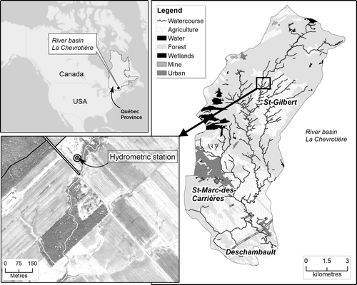
As previously mentioned, the study area is a 108-km2 watershed (Figure ) located in the province of Québec (centred at longitude 72°0’W and latitude 46°43’N). The watercourse, the La Chevrotière River, is about 29 km long with an average slope of about 1% (La Corporation d’aménagement et de protection de la rivière Sainte-Anne [CAPSA] Citation2011). The watershed starts at the northern shore of the St. Lawrence River to reach an elevation of 150 m upland. Based on slopes calculated using a 1-m resolution DEM, 40% of the watershed has slopes < 2% (~3°) followed by 47% having slopes between 2–8% (~3–9°), most of which are cropland, forest and urban areas. Near streams, the flat terrain becomes undulated with slopes > 8%, that are being exploited for farming, forest and shrubs (Nigel et al. Citation2013).
Figure 1. The study area, La Chevrotière River watershed (108 km2), Québec, Canada. The main economic activity of the basin is agriculture (crop, beef and dairy productions), which covers 29% of the watershed area.
The prevailing climate is humid continental. This is composed of significant temperature variations, with a hot summer, a cold winter and abundant precipitation. Average annual temperatures range from 4.2–5.8°C. The average annual precipitation recorded at a nearby station (period 1976–2006) is 1132 mm (standard deviation, SD = 88 mm), with a mean annual rainfall of 932 mm (SD = 89 mm) (Environment Canada [EC] Citation2007). Over the same period (1976–2006), the month with the highest rainfall amount was July with a mean of 125 mm and an SD of 28 mm (Nigel et al. Citation2013).
The average daily discharge (2006–2010) is 0.35 m3 s−1 (see Figure for the location of the hydrometric station), with the month of April having the largest average daily flow (1.15 m3 s−1, period 2006–2010) (MDDEP and Centre d’expertise hydrique du Québec [CEHQ] Citation2011). Although April is not the month with the highest rainfall, it is nonetheless the month where river flow and surface runoff are the most significant, and this is due to snowmelt and saturated soils. During the snowmelt period, high runoff combined with little vegetative cover contributes to substantial soil erosion.
Regarding land use, the main economic activity within the watershed is agriculture (crop production, beef production and dairy), which covers 29% of the watershed area. Forest is also present and covers 65% of the area. The rest are urban areas, road networks (5%) and water bodies-wetlands (1%) (CAPSA Citation2011).
Soils of the watershed belong to five taxonomic orders (Agriculture and Agri-Food Canada [AAFC] Citation2010):
Brunisols (soils formed under forest cover, ideal for agricultural production),
Gleysols (soils subject to water saturation, limited agricultural production),
Podzols (soils formed on acid parent materials under forest vegetation),
Regosols (sandy soils with poorly developed drainage), and
Organic (soils saturated with water for prolonged periods).
The soils are mostly clayey (St-Gilbert), coarse-loamy textured (in St-Marc-des-Carrières and Deschambault) and sandy (around St-Gilbert). Drainage classes (four categories) range from moderately well drained to poorly drained soils. Farm lands of St-Gilbert and St-Marc-des-Carrières are supported by mostly imperfectly, poorly and very poorly drained soils (Ministère de l’Agriculture, des Pêcheries et de l’Alimentation du Québec [MAPAQ] and Institut de recherche et de développement en agroenvironnement [IRDA] Citation2003).
Erosional processes and riparian buffer strips in the watershed
During the preliminary assessment of the watershed performed by CAPSA (the local watershed organization devoted to integrated water resources management), some 50 erosional zones were identified (covering all types of erosion features – agricultural, bank erosion, etc.). This included a dozen areas corresponding to steep cultivated riverine lands, and for which CAPSA has started planting herbaceous, shrubby and arborous species along the river banks. Additionally, in few instances, steep riverine hillslopes were planted with vegetation (in collaboration with land owners), which is an example of the possibility to “extend uphill” the RBS using some forms of permanent vegetative cover.
For 12 of the erosional riverine zones of the watershed, Nigel et al. (Citation2013) performed a field survey of erosion features during 4 days of the snowmelt period of April to May 2012, shortly after rainfall events. All of the 12 zones (53 ha) were under agricultural production located near river banks and had mostly bare tilled soils (or with little vegetation). Predominant erosion features observed were ephemeral gullies, sheet erosion and rills (~70% of all features observed). Most erosion features occurred on hillslopes greater than 8% and had lengths of 10–60 m. Nigel et al. (Citation2013) proposed to convert these steep cultivated hillslopes into extended RBSs of 10–60 m. This would potentially reduce erosion on steep slopes and at the same time effectively act as a boundary between the watercourse and damaging uphill erosion processes (sources of sedimentation and eutrophication). Building on this land surveying work, the next steps have been to:
Calculate with RUSLE the amount of soil loss for agricultural lands of the watershed with the actual small 1–3 m RBSs,
Design an extended RBS and calculate using RUSLE the relative gain in soil loss reduction when compared to the current situation.
Designing extended riparian buffer strips (RBSs)
Overall methodology
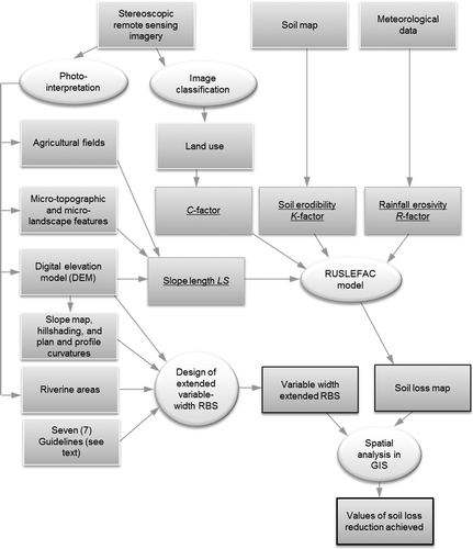
In the present study, the design of extended RBSs was achieved using ArcGIS software based on several criteria and the following GIS and remote sensing techniques (Figure ): (1) digitization of satellite imagery, (2) production of a DEM, (3) construction of slope map derived from the DEM, (4) hill-shading of the DEM and derivation of plan and profile curvatures to determine areas of flow convergence and divergence, (5) digitization of microtopographic and microlandscape features (for drainage enforcement on the DEM) obtained from image interpretation, (6) digitization of agricultural fields, and (7) computation of RUSLE soil loss map.
Figure 2. Flow chart showing overall methodological steps. RUSLEFAC, Revised Universal Soil Loss Equation for Application to Canada; RBS, riparian buffer strips; GIS, geographic information system.
Definition of criteria for the design
Dosskey et al. (Citation2002, 2008) performed a series of studies based on field observations (in the riparian zone) and modeling with the VFS dimensioning model (VFSMOD) of Muñoz-Carpena et al. (Citation1999). Based on these studies as well as some 1400 other research publications, Bentrup (Citation2008) synthesized and developed over 80 illustrated design guidelines for conservation buffers. Each guideline describes a specific way that a vegetative buffer can be applied to protect soil, improve air and water quality, enhance fish and wildlife habitat, produce economic products, provide recreational opportunities, or beautify the landscape. The followings are some of the general points to take into account when designing variable width extended RBSs to protect streams and watercourses (Bentrup Citation2008; Gumiere et al. Citation2013):
Sediment trapping and runoff reduction become more effective when the buffer width is large and when the flow is shallow and uniform,
Sediment trapping and runoff reduction by buffer is lower in the presence of convergent concentrated flow compared to the presence of uniform flow,
RBSs should have variable widths – smaller for places where the flow is divergent, shallow and uniform, and larger where the flow is convergent and concentrated,
The dimensions of the RBS should also be proportional to the uphill contributing area, taking into account flow convergence and divergence.
Furthermore, there are important characteristics of an RBS itself to consider, such as surface roughness, water level, terrain slope, groundwater return flow, capacity of the vegetation to uptake N and P and to degrade pesticides, and the re-entrainment of sediments and contaminants previously trapped in the vegetation (Bentrup Citation2008). These factors not only vary spatially along the buffer, but they also vary temporally, including the upslope contributing area, whose boundaries can change on flat parcels due to tillage operations (Souchere et al. Citation1998). As such, designing variable-width RBSs requires an understanding of upstream and local geomorphologic particularities and targeted contaminant type.
For example and as general guidelines to achieve specific objectives, the following RBS widths have been recommended (e.g. Palone and Todd Citation1997):
Streambank stabilization and aquatic food web –15 m
Water temperature moderation – 20 m
Nutrient removal – 40 m
Sediment control – 45 m
Flood control – 60 m
Wildlife habitat – 90 m
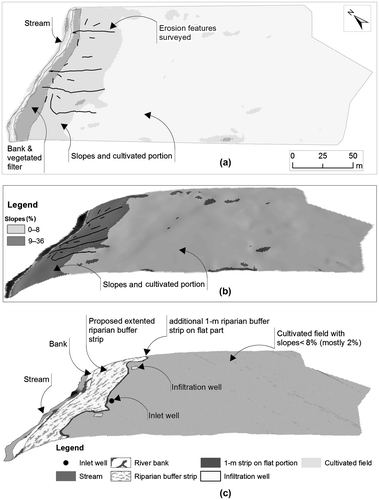
In the present study, the focus is on sediment and, to a lesser extent, nutrient controls using the extended RBS concept. A model of such an extended RBS is given in Figure for one of the surveyed fields of the present study area (Nigel et al. Citation2013). Figure a shows a plan view of a field where erosion features were surveyed, with an equivalent three-dimensional view in Figure b (vertical exaggeration factor of 3). Figure b shows the flat cultivated ledge and cultivated steep slopes (greater than 8%) where erosion features were observed. The proposal to no longer cultivate riverine steep slopes but to convert them into extended RBSs is illustrated in Figure c. The extended RBS of 40–60 m on the steep slopes is shown as an extension of the current 1–3 m RBS. After the extended RBS, and once the flat ledge is reached, an additional buffer strip (stiff grass hedges or grass barriers) of 1–2 m can be left to help spread out concentrated flows (Bentrup Citation2008). Once past this additional buffer strip, drainage systems can be installed, including inlet and infiltration wells and permeable trenches as means to drain water from the parcel to the stream (AAFC and MAPAQ Citation2007).
Figure 3. Conservation measures proposed; (a) the current situation in plan view and (b) in three-dimensional (3D) view; (c) the proposed extended riparian buffer strip (RBS) in 3D view.
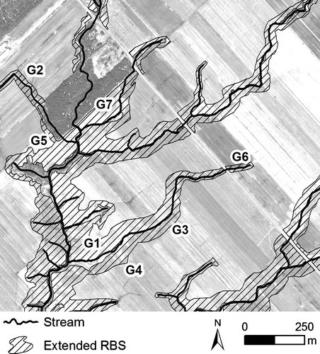
Therefore, in the present study, extended RBS with variable widths can be implemented in agricultural riverine lands and designed in such a way to extend from the present 1–3 m strip and to reach the flat ledge. For agricultural land that has shallow slopes (less than 8%) near the embankment, a simple extended RBS of 10 m can be designed (or 5 m for level fields with uniform flow). Thus, although wide RBSs of ~40 m should be envisaged to remove nutrients and sediments in flat agricultural landscapes, in the present study, this was not systematically favored, as a compromise was sought between water protection and the farmer’s total available land for agricultural production. On relatively flat slopes, erosion can be controlled such that soil conservation would not be a viable argument to obtain lands for conservation. In such flat areas, especially those with uniform flows, smaller RBSs of 5–10 m can be implemented (as a compromise). However, on steep slopes (greater than 8%), soil conservation with the additional benefit of water protection become strong arguments to obtain riverine lands to implement extended RBSs greater than 10 m, and up to 120 m, as was done in the present study (no compromise in areas with slopes greater than 8%). The seven guidelines adopted in the present study to design extended variable width RBS for agricultural riverine lands are shown in Figure :
Guideline #1 (G1): The extended RBS will cover all riverine slopes greater than 8% until the flat ledge is reached as shown in Figure .
Guideline #2 (G2): The extended RBS is small (5 or 10 m) in flatter riverine areas characterized by slopes much smaller than 8%.
Guideline #3 (G3): The extended RBS (inclusive of the additional stiff grass hedges or grass barriers) is placed along the contour (at the interface with the cultivated portion) to promote shallow flow across the buffer. This is done because if the contour is not closely followed, the buffer may enhance runoff and induce flow concentration; thereby reducing the buffer effectiveness (Bentrup Citation2008).
Guideline #4 (G4): At the intersection with watercourses or channels, the RBS is designed to be wider to cater to the incoming concentrated flow.
Guideline #5 (G5): In areas of divergent flow (concave or convex areas), the RBS should have a smaller width if the slope is much smaller than 8%. Areas of concentrated or divergent flows are derived from the DEM using plan and profile topographic curvatures tools of ArcGIS software (Nigel and Rughooputh Citation2010).
Guideline #6 (G6): In areas of uniform flow, such as in nearly level areas, the RBS has a smaller width.
Guideline #7 (G7): Landscape connectivity is maintained in areas of fragmentation, for instance in the presence of forest patches.
Figure 4. Variable-width extended riparian buffer strips (RBSs) designed using, amongst others, seven guidelines: G1 to G7 (see text for description of these guidelines).
Based on these guidelines, the extended variable-width RBS can be designed and then then tested (using the RUSLE erosion model) for soil erosion reductions achieved.
Calculating soil erosion with the RUSLE in GIS
The Universal Soil Loss Equation (USLE) developed by the United States Department of Agriculture (USDA) (Wischmeier and Smith Citation1978) and its revised version, RUSLE (Renard et al. Citation1997), are based on empirical predictive relationships between potential soil loss per unit area and all major factors known to influence rainfall sheet and rill erosion. Both equations have the form:(1)
where A is the spatial average annual soil loss (t ha−1 year−1), R is the annual rainfall erosivity factor (MJ mm ha−1 hr−1 year−1), K is the soil erodibility factor (t hr MJ−1 mm−1), LS is the slope length and steepness factor (dimensionless), C is the cover management factor (dimensionless, values ranging from 0–1) and P is the support practice factor (dimensionless, values ranging from 0–1). Note that in the above equation, SI units are used and the “t” in the units of A refers to the metric ton (i.e. 1000 kg or 1 Mg).
The original USLE, and its revised version, RUSLE, have been designed to produce a single quantitative output for a plot. Over the years, both models have been applied at the watershed scale using GIS (e.g. Ozsoy et al. Citation2012). Because a GIS application of the model requires simplification, GIS-based USLE or RUSLE modeling is commonly referred to as “semi-empirical” modeling of soil erosion (Nigel and Rughooputh Citation2013). The factor that is mostly simplified for GIS application is the topographic LS factor.
The inputs factors LS, C and P can be derived using remote sensing technologies and, thus, have good potential to be at high resolution. Thus, it would be advantageous to have a high-resolution GIS dataset for any one (if not for all) of these three factors for an area under study.
GIS database and remote sensing images of the present study area
A GIS database was built for the study watershed and included: a stereoscopic satellite image pair and auxiliary data, such as soil, cadastre, infrastructure, etc. The GIS projection is Modified Transverse Mercator, 7 (MTM7), with the North American Datum (NAD) Citation1983.
The stereoscopic satellite imagery characterizes bare soil following snowmelt and was captured by the satellite WorldView-2 on 14 April 2012 at 15:58 and 15:59 GMT. Each image has eight multispectral bands at 2-m spatial resolution and one panchromatic band at 0.5-m resolution. The captured images, which were in Universal Transverse Mercator (UTM) projection with WGS84 datum, were georeferenced to fit with the GIS database projection.
The stereoscopic image pair was used to generate a 1-m DEM. The stereo DEM generation is based on the British Aerospace (BAE) Systems flagship module called Next-Generation Automatic Terrain Extraction (NGATE) for stereo pairs (DeVencia et al. Citation2007). That module is based on image correlation algorithms to automatically extract elevation. During the process, image features such as roads, tracks, rivers, railways, motorways, etc., are additionally extracted using image interpretation and integrated in the DEM. The pixel spacing and vertical accuracy of the output DEM were both 1 m (Novoa et al. Citation2013).
In image processing, pansharpening is the process of fusing a high-resolution panchromatic (black and white) image with a lower-resolution multispectral (color) image in order to produce a high-resolution color image. In the present study, one of the stereo multispectral images at 2-m resolution (captured at 15:58 GMT) was pansharpened with the 0.5-m panchromatic image to generate a 0.5-m-resolution image with eight multispectral bands. The pansharpening was done with the software PCI Geomatics (PCI Geomatics Enterprises Citation2011).
Creating the RUSLE input and running the model
The rainfall erosivity factor R
The rainfall erosivity factor R is a measure of the total annual erosive rainfall for a specific location, as well as the distribution of erosive rainfall throughout the year (Wischmeier and Smith Citation1978). Rainfall erosivity is affected by storm energy and intensity, the amount of rainfall, snowfall and runoff that occurs during different seasons of the year, and snowmelt on top of frozen or partially frozen soil (Wall et al. Citation2002).
In RUSLE, rainfall erosivity R is computed using 22 years of rainfall intensity data as follows (Wischmeier and Smith Citation1978):(2)
where R is the rainfall erosivity factor (MJ mm ha−1 hr−1 year−1), E is the mean annual rainstorm kinetic energy (MJ ha−1 year−1) and I30 is the maximum storm intensity occurring over a period of 30 min (mm hr−1).
In addition to being data-intensive, computation of R with the above equation is also tedious and time-consuming. Thus, more feasible approaches of rainfall erosivity calculation based on available data, such as mean monthly rainfall depths, have been devised (e.g. Arnoldus Citation1980).
During the adaptation of RUSLE to Canada, Wall et al. (Citation2002) used an approach based on a 2-year return period, 6-hour rainfall depth (hereafter referred to as 2-yr, 6-hr rainfall). The equation used has the form:(3)
where P is the 2-yr, 6-hr rainfall (mm). The exponent β was defined by Ateshian (Citation1974) as having a value of 2.2. Meanwhile, Wischmeier and Smith (Citation1978) defined an exponent value of 2.17, the latter being also used by Foster et al. (Citation1981) when converting the USLE from US customary units to SI units. During an application of Equation (3) to eastern Canada, Wall et al. (Citation1983) used the value of 2.2, while Madramootoo (Citation1988) used the value of 2.17. In the manual of the model “RUSLE For Application to Canada (RUSLEFAC)”, an exponent of 2.17 is reported (Wall et al. Citation2002).
Whilst variations in the exponent β are observed, use of the above Equation (3) in RUSLEFAC with β = 2.17 is commonly referred to as the “Ateshian equation”. A simple comparison of both exponents (2.17 and 2.2) with meteorological data indicates a difference of 11% in the value of R. Nonetheless, in the present study, the “Ateshian equation” (Equation 3) with β = 2.17 was used to provide a complementary comparison with the erosivity map of Eastern Canada available in RUSLEFAC (Wall et al. Citation2002). Indeed, the latter erosivity map, scaled at 1:5 million roughly, can be used to estimate an R value for any location. Here, a rough estimate from the map gave a single value of 1200 MJ mm ha−1 hr−1 year−1 for the whole study area.
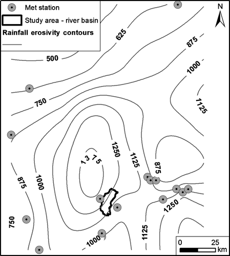
Another means of obtaining more spatially varying values of R covering the whole study area is to use Equation (3) with readily available meteorological data including the 2-yr, 6-hr rainfall. Such data were available from Environment Canada (EC). A total of 15 meteorological stations located at distances up to 140 km from the study watershed were retained with the aim of obtaining an erosivity raster grid that shows graded values across the study area. Use of this dataset resulted in erosivity values varying from 1300 MJ mm ha−1 hr−1 year−1 in the western part of the watershed to 1100 in the southeastern part (Figure ). The interpolation was performed using the spline technique, which provides good results with limited data (Hofierka et al. Citation2002). Additionally, the erosivity trend obtained (Figure ) is comparable to the RUSLEFAC erosivity map (Wall et al. Citation2002), the latter being based on a greater number of meteorological stations covering all of Eastern Canada.
Figure 5. Interpolation using the spline technique of data from 15 meteorological stations to create a grid of rainfall erosivity covering the study area. Erosivity contours are drawn at intervals of 125 MJ mm ha−1 hr−1 year−1.
The soil erodibility factor K
The soil erodibility factor K is a quantitative measure of a soil’s inherent susceptibility and resistance to erosion and the soil’s influence on runoff amount and rate. Erodibility is affected by soil texture and structure, organic matter content, permeability and season of the year (Wischmeier and Smith Citation1978). Canadian soils tend to be most susceptible in spring, especially under thawing conditions, and to be least erodible in the fall when the soil is dry and consolidated after the growing season (Wall et al. Citation2002).
In the present study, values of soil erodibility were obtained from CAPSA – the watershed organization of the study area. The soil erodibility data originated from partnership programs between agricultural organizations of provincial and federal governments and was mapped using the RUSLEFAC approach of Wall et al. (Citation2002), which accounts for frozen soil conditions of Canada. A soil erodibility value was assigned to each soil type on a digital vector soil map at a scale of 1:20 000 (a figure of the soil map can be found in Nigel et al. Citation2013). Erodibility values vary from 0.0026 t hr MJ−1 mm−1 for the sandy-textured soils of the gleysolic group to 0.04 and 0.05 t hr MJ−1 mm−1 for the organic and podzolic soil groups, which are soils characterized by coarse sandy loam texture and internal drainage varying from very poor to very high.
The topographic LS factor
Soil erosion is proportional to slope gradient (S) and its associated length (L), referred to as a combined term “slope-length” (LS) (Wischmeier and Smith Citation1978). Terrains with higher LS have higher erosion because of the higher runoff energy and volume associated with slope and length, respectively. Flat terrains, being characterized by lower LS, have comparatively lower erosion potential than steep, hilly or mountainous terrains, which are characterized by higher slopes and sometimes longer lengths. From a GIS standpoint and for complex terrain, LS can be computed using the following algorithms:
The unit stream power of Moore and Burch (Citation1986a, Citation1986b), Moore and Wilson (Citation1992) and Mitasova et al. (Citation1996),
The contributing area algorithm of Desmet and Govers (Citation1996), based on unit contour width contributing area, and
The maximum downhill slope angle calculations on grids (Hickey Citation2000; Van Remortel et al. Citation2004).
The unit stream power is the most widely used method (e.g. Conoscenti et al. Citation2008; Le Roux et al. Citation2008). The grid-based computer algorithm of Hickey (Citation2000) and Van Remortel et al. (Citation2004) is also often used (e.g. Lu et al. Citation2004), same as for the unit contributing area algorithm of Desmet and Govers (Citation1996) (e.g. Cohen et al. Citation2005; Nigel and Rughooputh Citation2010). The unit stream power and contributing area algorithm both make use of the upslope contributing area computed from flow accumulation algorithms.
The unit stream power approach gives comparable results to the contributing area algorithm (Nigel and Rughooputh Citation2010). However, the unit stream power approach can be directly performed in a GIS raster calculator, while the contributing area algorithm or the maximum downhill slope angle calculations on grids require the usage of specific software in which these algorithms were programmed. In the present study, the software of the contributing area algorithm and the software of the maximum downhill slope angle calculations on grids were tested. The outcome was that both software packages were not able to process the large amount of raster data of this work (size typically 1 GB). As such, the unit stream power approach used in GIS (namely ArcGIS software) was retained for use in this work, which has the form:(4)
where As is the upslope contributing area per unit contour width, θ is the slope angle and m and n are exponents, being 0.4 and 1.3 for USLE (Moore and Burch Citation1986b) and 0.6 and 1.3 for RUSLE (Moore and Wilson Citation1992), the latter being used in the present study.
Before calculating LS using the above equation, the DEM must be pre-processed in the GIS to remove pits and enforce drainage. Pits or depressions are low points completely surrounded by higher-elevation points and are the main difficulty in determining hydrological flow directions, because the depressions must be filled before flow can continue downstream (Jenson and Domingue Citation1988). Depression removal can significantly alter spatial and statistical distributions of terrain attributes (Lindsay and Creed Citation2005), which, according to Hancock (Citation2008), can affect soil loss estimation. In the present study, the pit removal module of ArcGIS software was used and is based on the algorithm of Jenson and Domingue (Citation1988).
Afterwards, drainage enforcement needs to be performed, which works by decreasing DEM elevation at watercourse locations in order to enforce drainage. Eventual calculations of upslope drainage area (and LS) on such pre-processed DEMs are based on flow accumulation, which is usually computed using only surface flow routing (as available in ArcGIS® software, for instance). However, micro-topographic features (e.g. land parcels, roadsdrainage networks) can also be accounted for, as these modify flow path (Duke et al. Citation2003; 2006), and thus slope length (Van Oost and Govers Citation2000). Furthermore, the flow routing should be derived using a multiple flow algorithm (such as the Direction-Infinity of Tarboton Citation1997), instead of the widely used single flow routing algorithm of Jenson and Domingue (Citation1988) (see for example, Desmet and Govers Citation1996; Mitasova et al. Citation1996; Mendicino Citation2000).
In the present study, such micro-topographic features were used during the drainage enforcement stage and using the Agree methodology of Hellweger (Citation1997) and implemented in ArcHydro Tools of Maidment (Citation2003). The micro-topographic features used were:
Roadside channels,
Within-plot channels,
Ditches between plots,
Channels separating plots from forest and other land uses, and
Streams and watercourses.
These micro-topographic features were obtained by manually digitizing the 0.5-m resolution WorldView-2 satellite image of 14 April 2012, while focusing on the 29 km2 of agricultural land of the study area. The result was 1175 km of micro-topographic features digitized for drainage enforcement, thereby accounting for the effects of land parcels, roads and drainage networks on overland flow routing.
After drainage enforcement was performed on the DEM, flow direction and flow accumulation were extracted using the Direction-Infinity (D-∞) of Tarboton (Citation1997) as implemented in TauDEM (Tarboton Citation2005). The flow accumulation grid obtained in this way represents upslope contributing area per unit contour width As that accounts for land parcels, roads and drainage networks, and is thus suitable for computing LS in a context of a detailed distributed (within-plot) soil loss estimate (calculation of LS done using Equation 4).
The C and P factors
The crop (vegetation) and management factor C is a measure of the relative effectiveness of soil and crop management systems in preventing or reducing soil loss. C is affected by crop canopy, surface cover, soil biomass and previous year’s crop, among other things. The support practice factor P is a measure of the effects of practices designed to modify the flow pattern, grade or direction of surface runoff and thus reduce the amount of erosion (Wall et al. Citation2002).
Values of C for the study area were obtained from the RUSLEFAC database of Wall et al. (Citation2002). A value of P = 1 (max value) was set to all plots after image analysis and field survey revealed no conservation practices as represented in the RUSLEFAC database were implemented in agricultural fields of the study area. The field survey was performed in 12 zones totaling 53 ha (Nigel et al. Citation2013). A land cover map for agricultural fields of the study area was created using supervised image classification of the 0.5-m satellite image of 14 April 2012, reaching an overall classification accuracy of 88%. Such a land cover map is in fact a C-factor map, and in the present study, five classes were chosen for the supervise classification (Table ) and mapped as shown in Figure .
Table 1. The five land cover classes mapped from the WorldView-2 imagery used to create a Revised Universal Soil Loss Equation (RUSLE) C-factor map of agricultural fields in the study area. Each land cover class is characterized by % vegetative ground cover on the ground during imagery capture in April 2012.
Figure 6. Land cover map derived using a 0.5-m resolution from the WorldView-2 satellite imagery and representing C factor values for the Revised Universal Soil Loss Equation (RUSLE). Bare soil, being mostly tilled plots, with little residue cover (< 30%) have the highest C value of 0.55. C value decreases with increasing % of vegetative cover on the ground to reach the lowest C value of 0.01 for grass (mostly pasture plots), being 90–100% vegetative (full) cover. Note that in the above, a plot can have different vegetative cover types in different areas of the plot, e.g. bare soil, ~70% vegetation cover and grass.
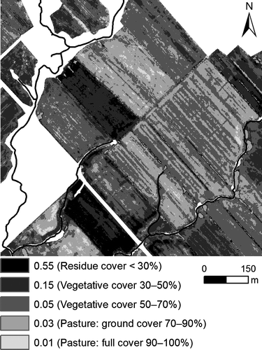
The maximum C-value is 0.55 for bare (tilled) soil, which has a residue cover of less than 30%. The lowest C-value is 0.01 for pasture, which has 90–100% ground cover. Tilled soil that has residue cover between 30 and 70%, or that has remnants of previous pasture vegetation covering 30–70% of the ground, accounts for 77% (22.2 km2) of the 28.8 km2 of agricultural fields in the study area. Pasture with 70–90% ground cover constitutes 4.8 km2 or 17% of the agricultural fields in the basin (Table ).
The C-factor map produced represents the on-site crop (vegetation) and management factor as inferred from the time of image capture on 14 April 2012, and does not necessarily represent the overall annual crop (vegetation) and management C-factor, as required by the RUSLE. For instance, due to vegetation growth, the bare soil of April 2012 would have later been covered with protective ground and/or aerial cover during summer and fall 2012, depending on the crop that would have been cultivated. Another example, pasture with 70–90% ground cover in April 2012, would have certainly reached ~100% ground cover in summer 2012.
In fact, each field should have been assigned its own crop, based on which each field would have been given a single annual C-value. In the present study, it was not possible with the satellite imagery and the field work of April 2012 to determine the final crop, or rotations or land use for the year. Thus, the C-values assigned in Table and mapped in Figure show the ground status of April 2012 and are used in the present study as a reflection of the “worst-case” annual scenario, since the spring snowmelt period of April–May is known to cause the highest erosion in regions geographically similar to the present study area (Kirby and Mehuys Citation1987; Duchemin et al. Citation2001; Wall et al. Citation2002).
Interpretation of the RUSLE results
The RUSLE soil loss map is produced, at a pixel size of 0.5 m, by multiplying the four factor layers in the GIS as described by the RUSLE function. Afterwards, the generated soil loss map was classified according to Wall et al. (Citation2002) for a better interpretation (see Table for the classes of soil loss). It must be noted that because of the simplifying assumptions made in the application of RUSLE (particularly those related to R and P), the values for annual soil loss should be interpreted as rough approximations, almost as indexes, rather than absolute representations.
Table 2. Percentage distribution of the different erosion categories (in all agricultural plots of the study area) with respect to: (1) actual soil loss estimates (under regulated 1–3 m RBS) and (2) conservation scenario of an extended riparian buffer strip (RBS).
Results and discussion
The extended RBS design based on the aforementioned seven guidelines suggested converting 1.9 km2 of riverine agricultural land into soil and water conservation areas (Figure ). The total area of agricultural land represents 28.8 km2. The proposed extended RBS will thus require the transformation of 7% of agricultural land (all located in riverine areas) into a form of 117-km-long stream corridor.
Figure 7. A total of 1.9 km2 (7%) of the 28.8 km2 of agricultural lands of the study area is proposed for conversion into extended variable-width riparian buffer strip (RBS) for soil conservation and water protection. The extended RBS would help reduce erosion in agricultural areas by 360 t year−1, i.e. from 909 to 549 t year−1, a reduction of 40%.
The total soil loss estimated with RUSLE for all agricultural fields is 909 t year−1 (0.3 t ha−1 year−1), out of which 361 t year−1 (1.9 t ha−1 year−1) potentially emanates from riverine areas. Should the extended RBS be composed of herbaceous, shrubby and arborous vegetation structures, then RUSLE C-factor would be 0.001 (based on the database included in Wall et al. Citation2002). Such a low RUSLE C-factor would result in total soil loss in the extended RBS being reduced from 361 t year−1 to 0.99 t year−1. This would help reduce the overall erosion in the study area by nearly 40% (from 909 to 549 t year−1, a reduction of 360 t year−1) at the expense of only 7% of agricultural land, all located in riverine areas.
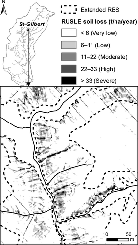
A portion of the RUSLE soil loss map for the agricultural fields of St-Gilbert village is shown in Figure . Higher soil loss estimates – characterized by rills due to larger slope length and concentrated channelized flow – are mostly located in the riverine zone, which is where the proposed extended RBS is located.
Figure 8. Revised Universal Soil Loss Equation (RUSLE) soil loss for the study area. Very low erosion predominates on the flat ledge. In areas where the extended riparian buffer strip (RBS) is designed for implementation, low, moderate, high and severe erosion predominate.
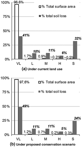
The total surface area and total soil loss of the different erosion categories (very low, moderate, etc.) are contrasted in Table . Under current land use, the category “very low erosion” occupies a total surface area of 27.83 km2. This represents ~97% of the total surface area of agricultural land in the study area (Figure a). Although the “very low erosion” category is spatially occupying most of the study area, it is, however, accounting for ~41% of the total soil loss in the study area (i.e. 370 t year−1). The reason for this is that although the study area is predominantly flat, it nevertheless possesses gentle to rolling slopes in riverine areas, and this is where the majority of soil loss and erosion processes are taking place. Thus, with an extended RBS, a majority of the current moderate, high and severe erosion classes would be converted into very low (i.e. tolerable) soil erosion (Table ). Therefore, the proposition to target steep cultivated riverine areas for conservation efforts would reduce the predominance of the erosion categories “moderate”, “high” and “severe” in the study area from 49 to ~40% (Figure b).
Figure 9. Percentage distribution of erosion categories (low, moderate, etc.) according to their total surface area and total soil loss. The distributions are shown for both the current land use and the proposed extended riparian buffer strips (RBS). Under current land use, the category “very low (VL) erosion” predominates spatially (96.6% of total surface) but contributes to 41% of the total soil loss. Under the conservation scenario, the VL category contributes to greater total soil loss (49%), while the “Severe” category contributes less (from 32 to 24%).
Only a portion of the RUSLE soil loss estimate presented above is delivered to stream channels. The concept of a sediment delivery ratio (SDR) is usually employed to convert a portion (%) of RUSLE soil loss estimate into a prediction of sediments delivered to watercourses (Lim et al. Citation2005). The value of SDR varies depending on the study area. In the present study, assuming a SDR value of 10% (ratio 0.1) would mean that sediment delivered to streams would be estimated at 91 t year−1.
As confirmed by previous field work in the study area, slope plays an important role in erosion processes, such that steep slopes are definitely prone to erosion (Nigel et al. Citation2013). In such slopes, the easiest way to proceed is to conserve the entire slope up to the flat ledge with an extended RBS (see Figure ). This would enable us to effectively take into account the slope gradient and its length (LS), which are the determining parameters for the topographic factor in erosion processes (see e.g. Nigel and Rughooputh Citation2010).
On flatter slopes that do not have the same configuration as the prototype shown in Figure , the method to determine the width of extended RBSs should account not only for topography but also for soil type, turbulent flow, etc. There exist physically based models to dimension riparian buffers in flat areas which account for such factors. Some examples are the Vegetative Filter Strip Model (VFSMOD) model of Muñoz-Carpena et al. (Citation1999), the Trava model of Deletic (Citation2001), and VFDM of Gumiere et al. (Citation2013).
Other simpler tools that rely on empirical relationships derived from RUSLE and using also a portion of physically based models are described in Dosskey et al. (Citation2002, 2008) and Bentrup (Citation2008). Such simple tools are meant for practical applications. The method proposed herein has the same philosophy as these simple tools: to be used for practical purposes. The innovation here is that the conceptual design makes use of remote sensing and GIS techniques. In general, application of the proposed methodology requires availability of at least one input data to RUSLE at a high resolution (e.g. 50 cm or 1–2 m). Such high-resolution data can be obtained for the C-factor or the LS-factor by using remote sensing technologies. In this present study, the WorldView-2 satellite provided the required high-resolution data at a 50-cm resolution for the C-factor and at a 1-m resolution for the LS-factor.
Locally, from a farmer’s standpoint, it may be argued that the conversion of large sections of cultivated riverine areas into extended RBSs would decrease the land available for agricultural productivity, thus resulting in economic losses. However, the current provincial “Prime-Vert” program supports farms so that they can comply with provincial laws, regulations and environmental policies (MAPAQ Citation2012). In the event that the policy in place fosters the regulation of steep cultivated lands next to watercourses as conservation areas, then the “Prime-Vert” program may provide financial compensation for such land conservation scenarios – albeit this can be very complex to implement in Québec, as discussed by L’Italien (Citation2012). In addition to provincial programs, other organizations could also be interested in providing compensation for conservation scenarios. For instance, during the 2006–2010 period, the “Fondation de la Faune du Québec” put together a monetary compensation program to support 522 farmers for land and biodiversity conservation next to watercourses (Fondation de la Faune du Québec [FFQ] Citation2011).
An extended RBS, as proposed in this work, would also be beneficial to biodiversity. For instance, Spackman and Hughes (Citation1995) showed that RBSs 10–15 m wide can recover 90% of terrestrial vascular plants found in their territory (Vermont, USA), with birds and mammals establishing well beyond this distance. Based on studies in the Boyer River in Québec, Maisonneuve and Rioux (Citation2001) recommended that to maintain a good biodiversity of small mammals and herpetofauna, there needs to be a complexity of vegetation structure in a RBS (woody, shrubby and herbaceous), and that the number of species present increases with an increase in riparian buffer width.
Conversion of steep cultivated slopes into buffer strips will also be economically beneficial to farmers through gains on reduced fertilizers and reduced soil loss – since soil has its own value too, as well as reduced time spent to fix up the erosion scares (MDDEP Citation2007b). Watershed organizations such as the CAPSA also have the technical know-how and manpower to assist farmers to conceive profitable scenarios – both economically and environmentally (Fédération interdisciplinaire de l’horticulture ornementale du Québec [FIHOQ] Citation2013).
Conclusion
In this study, a variable-width riparian buffer strip (RBS) concept was designed for agricultural riverine land using geospatial information on terrain, land cover and soil. Afterwards, the level of soil loss reduction achievable with the variable-width RBS was calculated using the Revised Universal Soil loss Equation (RUSLE) within a geographic information system (GIS). The rationale behind this study is that conversion of steep cultivated riverine slopes (and areas) into extended RBSs provides a means of converting high-risk agricultural riverine land into more sustainable and environmentally friendly land cover. Indeed, in this work, it was shown, using high-resolution, remote sensing, raster-based information (namely WorldView-2 satellite products at a 50-cm resolution for the C-factor and at a 1-m resolution for the LS-factor) that such a proposed conservation scenario would reduce soil erosion in riverine areas from 361 to 1.0 t year−1 (1.9 to 0.005 t ha−1 year−1), thereby reducing soil erosion in the studied watershed by 40%. The extended RBS would require the conversion of only 7% of the 29 km2 of agricultural land in the watershed. The extended RBS, once composed of herbaceous, shrubby and arborous vegetation structures, would act as a 117-km long forested stream corridor that would foster: (1) landscape connectivity for fauna, (2) aquatic biodiversity, (3) terrestrial biodiversity, (4) free stream meandering and (5) bank stabilization in areas.
Acknowledgements
This research was supported by the Growing Forward initiative (Cultivons l’avenir), a joint partnership between AAFC and MAPAQ, under the “Programme de soutien à l’innovation en agroalimentaire” (PSIA), Project # 811083.
References
- Agriculture and Agri-Food Canada (AAFC). 2010. The Canadian system of soil classification, 3rd edition. AAFC. http://sis.agr.gc.ca/cansis/taxa/cssc3/intro.html ( accessed August, 2012).
- Agriculture and Agri-Food Canada (AAFC), and Ministère de l’Agriculture, des Pêcheries et de l’Alimentation du Québec (MAPAQ). 2007. Diagnosis and solutions for field erosion and surface drainage problems. http://www4.agr.gc.ca/resources/prod/doc/terr/pdf/Diagnosis_and_Solutions_for_Field_Erosion.pdf ( accessed August, 2012).
- Arnoldus, H. M. J. 1980. An approximation of the rainfall factor in the universal soil loss equation. In Assessment of erosion, edited by M. De Boodt and D. Gabriels, 127–132. Rome, Italy: John Wiley & Sons.
- Ateshian, J. K. H. 1974. Estimation of rainfall erosion index. Journal of Irrigation and Drainage Division, American Society of Civil Engineering 100(1): 293–307.
- Bentrup, G. 2008. Conservation buffers: design guidelines for buffers, corridors, and greenways. Gen. Tech. Rep. SRS-109. Asheville, NC: Department of Agriculture, Forest Service, Southern Research Station.
- Blanco-Canqui, H., C. J. Gantzer, and S. H. Anderson. 2006. Performance of grass barriers and filter strips under interrill and concentrated flow. Journal of Environmental Quality 35(6): 1969–1974.
- Cohen, M. J., K. D. Shepherd, and M. G. Walsh. 2005. Empirical reformulation of the universal soil loss equation for erosion risk assessment in a tropical watershed. Geoderma 124(3–4): 235–252.
- Conoscenti, C., C. Maggio, and E. Rotigliano. 2008. Soil erosion susceptibility assessment and validation using a geostatistical multivariate approach: a test in Southern Sicily. Natural Hazards 46(3): 287–305.
- La Corporation d’aménagement et de protection de la rivière Sainte-Anne (CAPSA). 2011. Organisme des bassins versants des rivières Sainte-Anne, Portneuf, La Chevrotière et Belle-Isle. Portrait préliminaire des nouvelles zones de gestion intégrée de l’eau par bassin versant de la CAPSA : les bassins versants des rivières La Chevrotière et Belle-Isle. St-Raymond, Québec: CAPSA.
- Dabney, S. M., L. D. Meyer, W. C. Harmon, C. V. Alonso, and G. R. Foster. 1995. Depositional patterns of sediment trapped by grass hedges. Transactions of the American Society of Agricultural Engineers 38(6): 1719–1729.
- Deletic, A. 2001. Modelling of water and sediment transport over grassed areas. Journal of Hydrology 248(1–4): 168–182.
- Desmet, P. J. J., and G. Govers. 1996. A GIS procedure for automatically calculating the USLE LS factor on topographically complex landscape units. Journal of Soil and Water Conservation 51(5): 427–433.
- DeVencia, K., S. Walker, and B. Zhang. 2007. New approaches to generating and processing high resolution elevation data with imagery. In Photogrammetric Week. http://www.ifp.uni-stuttgart.de/publications/phowo07/330DeVenecia.pdf (accessed 7 August, 2014), Stuttgart.
- Dillaha, T. A., J. H. Sherrard, and D. Lee. 1986. Long-term effectiveness and maintenance of vegetative filter strips. Viginia Polytechnique Institut – Virginia Water Resources Research Center Bulletin 153: 1–33.
- Dillaha, T. A., R. B. Reneau, S. Mostaghimi, and D. Lee. 1989. Vegetative filter strips for agricultural nonpoint source pollution control. Transactions of the American Societey of Agricultural Engineers 32(2): 513–519.
- Dosskey, M. G., Eisenhauer D. E., and Helmers, M. J. 2005. Establishing conservation buffers using precision information. Journal of Soil and Water Conservation 60(6): 349–354.
- Dosskey, M. G., M. J. Helmers, and D. E. Eisenhauer. 2008. A design aid for determining width of filter strips. Journal of Soil and Water Conservation 63(4): 232–241.
- Dosskey, M. G., M. J. Helmers, and D. E. Eisenhauer. 2011. A design aid for sizing filter strips using buffer area ratio. Journal of Soil and Water Conservation 66(1): 29–39.
- Dosskey, M. G., M. J. Helmers, D. E. Eisenhauer, T. G. Franti, and K. D. Hoagland. 2002. Assessment of concentrated flow through riparian buffers. Journal of Soil and Water Conservation 57(6): 336–343.
- Duchemin, M., M. Lachance, R. Lagacé, and G. Morin. 2001. Approche géomatique pour simuler l’érosion hydriqueet le transport des sédiments à l’échelle des petits bassins versants. Water Quality Research Journal of Canada 36(3): 435–473.
- Duke, G. D., S. W. Kienzle, D. L. Johnson, and J. M. Byrne. 2003. Improving overland flow routing by incorporating ancillary road data into Digital Elevation Models. Journal of Spatial Hydrology 3(2): 1–22.
- Duke, G. D., S. W. Kienzle, D. L. Johnson, and J. M. Byrne. 2006. Incorporating ancillary data to refine anthropogenically modified overland flow paths. Hydrological Processes 20(8): 1827–1843.
- Environment Canada (EC). 2007. Canadian Daily Climate Data (CDCD). Environment Canada (EC), Ottawa, Ontario. ftp://ftp.tor.ec.gc.ca/Pub/Data/Canadian_Daily_Climate_Data_CDCD/ ( accessed September, 2012).
- Fédération interdisciplinaire de l’horticulture ornementale du Québec (FIHOQ). 2013. Plantation et entretien d’une bande riveraine – Pour une restauration durable. Fédération interdisciplinaire de l’horticulture ornementale du Québec (FIHOQ). http://banderiveraine.org/ ( accessed January, 2014).
- Foster, G. R., D. K. McCool, K. G. Renard, and W. C. Moldenhauer. 1981. Conversion of the universal soil loss equation to SI metric units. Journal of Soil and Water Conservation 36(6): 355–359.
- Fondation de la Faune du Québec (FFQ). 2011. Wildlife initiatives – biodiversity in farming communities. Fondation de la Faune du Québec (FFQ). http://www.fondationdelafaune.qc.ca/initiatives/biodiversite_en_milieu_agricole ( accessed September, 2012).
- Gumiere, S. J., Y. Le Bissonnais, D. Raclot, and B. Cheviron. 2011. Vegetated filter effects on sedimentological connectivity of agricultural catchments in erosion modelling: a review. Earth Surface Processes and Landforms 36(1): 3–19.
- Gumiere, S. J., A. N. Rousseau, D. W. Hallema, and P.-E. Isabelle. 2013. Development of VFDM: a riparian vegetated filter dimensioning model for agricultural watersheds. Canadian Water Resources Journal 38(3): 169–184.
- Hancock, G. R. 2008. The impact of depression removal on catchment geomorphology, soil erosion and landscape evolution. Earth Surface Processes and Landforms 33(3): 459–474.
- Hellweger, F. 1997. AGREE – DEM Surface Reconditioning System. http://www.ce.utexas.edu/prof/maidment/GISHYDRO/ferdi/research/agree/agree.html ( accessed January, 2013).
- Hickey, R. 2000. Slope angle and slope length solutions for GIS. Cartography 29(1): 1–8.
- Hofierka, J., J. Parajka, H. Mitasova, and L. Mitas. 2002. Multivariate interpolation of precipitation using regularized spline with tension. Transactions in GIS 6(2): 135–150.
- Jenson, S. K., and J. O. Domingue. 1988. Extracting topographic structure from digital elevation data for geographic information system analysis. Photogrammetric Engineering and Remote Sensing 54(1): 1593–1600.
- Kirby, P. C., and G. R. Mehuys. 1987. The seasonal variation of soil erosion by water in southwestern Québec. Canadian Journal of Soil Science 67(1): 55–63.
- Le Roux, J. J., T. L. Morgenthal, J. Malherbe, D. J. Pretorius, and P. D. Sumner. 2008. Water erosion prediction at a national scale for South Africa. Water South Africa 34(4): 305–314.
- Lim, K. J., M. Sagong, B. A. Engel, Z. Tang, J. Choi, and K. Kim, 2005. GIS-based sediment assessment tool. CATENA 64(1): 61–80.
- Lindsay, J. B., and I. F. Creed. 2005. Removal of artifact depressions from digital elevation models: towards a minimum impact approach. Hydrological Processes 19(16): 3113–3126.
- L’Italien, F. 2012. L’accaparement des terres et les dispositifs d’intervention sur le foncier agricole – Les enjeux pour l’agriculture québécoise. Research Report. Institut de recherche en économie contemporaine (IREC), Montréal. http://www.upa.qc.ca/ScriptorBD/publication/204694/Accaparement%20des%20terres%20Mars%202012.pdf ( accessed September, 2012).
- Lu, D., G. Li, G. S. Valladares, and M. Batistella. 2004. Mapping soil erosion risk in Rondônia, Brazilian Amazonia: using RUSLE, remote sensing and GIS. Land Degradation & Development 15(5): 499–512.
- Madramootoo, C. A. 1988. Rainfall and runoff erosion indices for eastern Canada. Transactions of the ASAE 31(1): 107–110.
- Maidment, D. R. 2003. ArcHydro: GIS for water resources. Redlands, CA: ESRI Press.
- Maisonneuve, C., and S. Rioux. 2001. Importance of riparian habitats for small mammal and herpetofaunal communities in agricultural landscapes of southern Québec. Agriculture, Ecosystems & Environment 83(1–2): 165–175.
- Mendicino, G. 2000. Sensitivity Analysis on GIS Procedures for the Estimate of Soil Erosion Risk. Natural Hazards 20: 231–253.
- Ministère de l’Agriculture, des Pêcheries et de l’Alimentation du Québec (MAPAQ). 2012. Prime-Vert program to promote and disseminate good agricultural practices. MAPAQ. http://www.mapaq.gouv.qc.ca/fr/Productions/md/programmesliste/agroenvironnement/Pages/primevert.aspx ( accessed December, 2013).
- Ministère de l’Agriculture, des Pêcheries et de l’Alimentation du Québec (MAPAQ), and Institut de recherche et de développement en agroenvironnement (IRDA). 2003. Pédologie (fichiers numériques) de source Inventaire des terres du Canada de Aménagement rural et développement de l’agriculture (ARDA). Échelle de numérisation: 1: 20 000, année de numérisation: 1998–2003. Ville de Québec, Québec: MAPAQ & IRDA.
- Ministère du développement durable, environnement et parcs Québec (MDDEP). 2007a. Protection des rives, du littoral et des plaines inondables: guide d’interprétation. Edited by C. Michaud and P. Dubois, Québec. MDDEP. Direction Des Politiques. Développement durable, environnement et parcs Québec.
- Ministère du développement durable, environnement et parcs Québec (MDDEP). 2007b. Vos lacs et cours d’eau – une valeur à préserver en milieu agricole. MDDEP. Ville de Québec, Québec. http://www.mddep.gouv.qc.ca/eau/rives/agricole/index.htm ( accessed August, 2012).
- Ministère du développement durable, environnement et parcs Québec (MDDEP), and Centre d’expertise hydrique du Québec (CEHQ). 2011. Fiche signalétique de la station 050501 – La Chevrotière.: MDDEP & CEHQ, Ville de Québec, Québec. http://www.cehq.gouv.qc.ca/depot/historique_donnees_som_mensuels/050501_Q_MOY.txt ( accessed September, 2012).
- Mitasova, H., J. Hofierka, M. Zlocha, and L. R. Iverson. 1996. Modelling topographic potential for erosion and deposition using GIS. International Journal of Geographical Information Systems 10(5): 629–641.
- Moore, I. D., and G. Burch. 1986a. Modeling erosion and deposition: topographic effects. Transactions of the American Society of Agricultural Engineers 29(6): 1624–1630.
- Moore, I. D., and G. Burch. 1986b. Physical basis of the length-slope factor in the universal soil loss equation. Soil Science Society of America Journal 50: 1294–1298.
- Moore, I. D., and J. P. Wilson. 1992. Length-slope factors for the Revised Universal Soil Loss Equation: Simplified method of estimation. Journal of Soil and Water Conservation 47: 423–428.
- Muñoz-Carpena, R., J. E. Parsons, and J. W. Gilliam. 1999. Modeling hydrology and sediment transport in vegetative filter strips. Journal of Hydrology 214(1–4): 111–129.
- Nieswand, G. H., R. M. Hordon, T. B. Shelton, B. B. Chavooshian, and S. Blarr. 1990. Buffer strips to protect water supply reservoirs: A model and recommendations. Journal of the American Water Resources Association 26(6): 959–966.
- Nigel, R., and S. D. D. V. Rughooputh. 2010. Soil erosion risk mapping with new datasets: An improved identification and prioritisation of high erosion risk areas. CATENA 82(3): 191–205.
- Nigel, R., and S. D. D. V. Rughooputh. 2013. Application of a RUSLE-based soil erosion modelling on Mauritius Island. Soil Research 50(8): 645–651.
- Nigel, R., K. Chokmani, J. Novoa, A. N. Rousseau, and P. Dufour. 2013. Recommendations for riparian buffer widths based on field surveys of erosion processes on steep cultivated slopes. Canadian Water Resources Journal 38(4): 263–279.
- Novoa, J., K. Chokmani, R. Nigel, and P. Dufour. 2013. Quality assessment from a hydrologic perspective of a digital elevation model derived from WorldView-2 remote sensing data. Hydrological Sciences Journal doi:10.1080/02626667.2013.875179
- Ozsoy, G., E. Aksoy, M. S. Dirim, and Z. Tumsavas. 2012. Determination of soil erosion risk in the Mustafakemalpasa River Basin, Turkey, using the Revised Universal Soil Loss Equation, Geographic Information System, and remote sensing. Environmental Management 50(4): 679–694.
- Palone, R. S., and A. H. Todd. 1997. Chesapeake Bay riparian handbook: a guide for establishing and maintaining riparian forest buffers. USDA Forest Service Northeastern Area State and Private Forestry NA-TP-02-97. Radnor, PA http://www.chesapeakebay.net/content/publications/cbp_13019.pdf ( accessed March, 2013).
- PCI Geomatics Enterprises. 2011. PCI focus. Richmond Hill, ON: PCI Geomatics Enterprises.
- Renard, K. G., G. R. Foster, G. A. Weesies, D. K. McCool, and D. C. Yoder. 1997. Predicting soil erosion by water: a guide to conservation planning with the revised universal soil loss equation (rusle). Tucson, AZ: USDA-ARS, Southwest Watershed Research Center.
- Schmitt, T. J., M. G. Dosskey, and K. D. Hoagland. 1999. Filter strip performance and processes for different vegetation, widths, and contaminants. Journal of Environmental Quality 28(5): 1479–1489.
- Souchere, V., D. King, J. Daroussin, F. Papy, and A. Capillon. 1998. Effects of tillage on runoff directions: consequences on runoff contributing area within agricultural catchments. Journal of Hydrology 206(3–4): 256–267.
- Spackman, S. C., and J. W. Hughes. 1995. Assessment of minimum stream corridor width for biological conservation: Species richness and distribution along mid-order streams in Vermont, USA. Biological Conservation 71(3): 325–332.
- Tarboton, D. G. 1997. A new method for the determination of flow directions and upslope areas in grid digital elevation models. Water Resources Research 33(2): 309–319.
- Tarboton, D. G. 2005. Terrain analysis using Digital Elevation Models (TauDEM). http://hydrology.usu.edu/taudem/taudem5/index.html ( accessed December, 2013).
- Trenholm, R., V. Lantz, R. Martínez-Espiñeira, and S. Little. 2013. Cost-benefit analysis of riparian protection in an eastern Canadian watershed. Journal of Environmental Management 116: 81–94.
- Van Dijk, P. M., F. J. P. M. Kwaad, and M. Klapwijk. 1996. Rentention of water and sediment by grass strips. Hydrological Processes 10(8): 1069–1080.
- Van Oost, K., and G. Govers. 2000. Evaluating the effects of changes in landscape structure on soil erosion by water and tillage. Landscape Ecology 15: 577–589.
- Van Remortel, R. D., R. W. Maichle, and R. J. Hickey. 2004. Computing the LS factor for the Revised Universal Soil Loss Equation through array-based slope processing of digital elevation data using a C++ executable. Computers & Geosciences 30(9–10): 1043–1053.
- Wall, G. J., J. Greuel, and W. T. Dickinson. 1983. Rainfall erosion indices for Canada east of the Rocky Mountains. Canadian Journal of Soil Science 63(2): 271–280.
- Wall, G. J., D. R. Coote, E. A. Pringle, and I. J. Shelton eds. 2002. RUSLE-CAN – Universal soil loss equation for application in Canda. Manual for evaluation of soil loss by water erosion in Canada. Ottawa, Ontario: Research Branch of Agriculture and Agri-Food Canada (AAFC), Contribution no. AAC2244F.
- Wischmeier, W., and D. Smith. 1978. Predicting rainfall erosion losses: a guide to conservation planning. Vol. 537 of Agriculture handbook: Washington, DC: USDA.