
Abstract
Efficiency gains from on-farm irrigation system upgrades and canal rehabilitation in southern Alberta irrigation districts are influenced by weather variability. The Irrigation Demand Model was used to estimate differences in on-farm demand and conveyance losses based on irrigation district characteristics in 1999 and 2012 using weather data from 1928 to 2012. Monte Carlo simulations were subsequently performed to determine the magnitude of potential efficiency gains at different chances of exceedance. Changes in irrigation systems and water conveyance infrastructure reduced gross demand by 74 mm from 1999 to 2012, with a 55-mm reduction in on-farm demand and a 19-mm decrease in conveyance losses at a 10% chance of exceedance. Reductions in gross demand on a volume basis from 1999 to 2012 ranged from 170 to 200 million m3, even with about 30,300 ha of irrigation expansion. Conveyance loss reductions were stable at about 50 million m3, so 70 to 75% of the potential water savings were achieved through reduced on-farm demand. Mean seasonal naturalized flows available for use in southern Alberta from 1912 to 2009 ranged from 2.08 billion m3 in high-demand years to 3.95 billion m3 in wet years. Gross demand based on irrigation district characteristics in 2012 varied from 1.73 billion m3 in wet years to 2.83 billion m3 in high-demand years. Additional gains in efficiency from on-farm irrigation system upgrades and rehabilitation of conveyance infrastructure in the future will help mitigate the increased risk of water scarcity as irrigation districts expand with current licensed water allocations.
Les gains d’efficacité suite à l’amélioration des systèmes d’irrigation à la ferme et la réhabilitation des canaux des districts d’irrigation du sud de l’Alberta sont influencés par la variabilité des conditions météorologiques. Le modèle de demande en irrigation a été utilisé pour estimer les différences entre 1999 et 2012 pour la demande d’irrigation à la ferme et les pertes liées au transport de l’eau d’irrigation à l'aide de données météorologiques de 1928 à 2012. Par la suite, les simulations de Monte Carlo ont été effectuées afin de déterminer l’ampleur des gains d’efficacité potentiels selon différentes possibilités de dépassement. Les changements dans les systèmes d’irrigation à la ferme et les canaux d’irrigation suite à la réhabilitation ont permis de réduire la demande brut en volume d’eau de 74 mm entre 1999 et 2012, avec une réduction de 55 mm de demande à la ferme et une diminution de 19 mm en pertes durant le transport selon une chances de dépassement de 10%. Les réductions de demande en volume brut variaient entre 170 et 200 millions de m3 entre 1999 et 2012, même avec l’expansion d’environ 30 300 ha en terre irriguées. La réduction des pertes lors du transport de l’eau était stable avec environ 50 millions de m3; ainsi 70 à 75% des économies potentielles d’eau ont été atteintes par la baisse de la demande à la ferme. Le débit saisonnier naturalisé moyen disponible dans le sud de l’Alberta entre 1912 et 2009 variait de 2.08 milliards de m3 pendant les années où la demande était élevée et 3,95 milliards de m3 pour les années pluvieuses. La demande en eau brute selon les caractéristiques des districts d’irrigation de 2012 variait de 1,73 milliards de m3 pour les années pluvieuses à 2,83 milliards de m3 pour les années de demande élevée. Les gains additionnels d’efficacité grâce aux futures améliorations des systèmes d’irrigation à la ferme et aux futures réhabilitation des infrastructures de transport de l’eau d’irrigation, aideront à atténuer l'augmentation du risque de pénurie en eau, liés à l’expansion des districts d’irrigation sous leurs licences actuelles d’allocations en eau.
Introduction
Improved water-use efficiencies of rehabilitated conveyance infrastructure and on-farm irrigation systems in irrigated agriculture are essential to ensure the future availability of water for global food, fibre and bio-energy production. Irrigated agriculture currently uses approximately 70% of total water withdrawals worldwide and produces about 40% of global food production on less than 20% of the cropped land (Food and Agriculture Organization of the United Nations [FAO] Citation2011). World population is expected to reach 9 billion by 2050 (FAO 2011). This population growth and changing dietary preferences in developing countries will necessitate a 70 to 100% increase in global food production (Godfray et al. Citation2010; FAO Citation2011). Increased demand for freshwater supplies from urban and industrial users, environmental needs of source waters, and climate change will also result in increased competition with agriculture for water (Hanjra and Qureshi Citation2010; Turral et al. Citation2010).
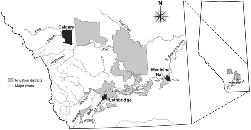
Water supplies for licensed uses in Alberta are primarily surface water derived from precipitation (rain and snow) in the Oldman and Bow River Basins (Figure ), which have headwaters in the Rocky Mountains (AMEC Citation2009). About 555,200 ha were assessed for irrigation within the 13 irrigation districts in southern Alberta (Figure ), and 105,700 ha were licensed for private irrigation projects in 2012 (Alberta Agriculture and Rural Development Citation2013a). Irrigation districts have recently authorized the expansion of their irrigated area to 612,200 ha based on improvements in infrastructure and operations for water conveyance and on-farm irrigation system upgrades to more efficient low-pressure centre-pivot irrigation systems (Bennett et al. Citation2013). About 75% of the total volume of water allocations in the South Saskatchewan River Basin (SSRB) is licensed for irrigation (Alberta Environment Citation2003). The current licensed allocation for the irrigation districts is 3.45 billion m3 (Alberta Agriculture and Rural Development Citation2013a) and the mean annual discharge into Saskatchewan from the SSRB in Alberta is 9.28 billion m3 (Alberta Environment and Sustainable Resource Development Citation2014). Under a Master Agreement on Apportionment, Alberta is entitled to use or store one half of the annual natural river flow of the South Saskatchewan River downstream of its confluence with the Red Deer River, less United States withdrawals from the St. Mary River system in Montana (AMEC Citation2009). The Bow, Oldman and South Saskatchewan sub-basins in the SSRB have been closed to new water license applications since 2007 (AMEC Citation2009).
Figure 1. Irrigation districts and major rivers in southern Alberta.
Irrigation districts in Alberta have developed an irrigation sector plan under Alberta’s Water for Life Strategy to voluntarily increase water conservation, efficiency and productivity by 30% from 2005 to 2015 (Alberta Irrigation Projects Association Citation2010). Water delivery infrastructure in the irrigation districts includes about 7600 km of conveyance works, 170 major structures and about 4700 km of drainage works valued at more than CAD $3.6 billion (Alberta Agriculture and Rural Development Citation2013a). A cost-shared Irrigation Rehabilitation Program initiated by the Government of Alberta in 1969 to rehabilitate irrigation water delivery infrastructure (Ring et al. Citation2005) has invested more than CAD $1 billion so far to increase water conveyance efficiencies. Almost CAD $463 million of this investment has been made since 1999. Additional rehabilitation of water conveyance infrastructure has been completed by irrigation districts with their own financial resources.
Substantial investments in more efficient sprinkler irrigation equipment and pumps have also been made by irrigators. About two thirds of the irrigated area in the irrigation districts is currently irrigated with low-pressure centre-pivot irrigation systems, 9.6% is irrigated with high-pressure centre pivots, 13.6% is irrigated with wheel-move systems and 9.5% is irrigated by gravity methods (Alberta Agriculture and Rural Development Citation2013a). The total replacement value of all on-farm irrigation systems within the irrigation districts is about CAD $1 billion, and the current value of investments in irrigation system upgrades since 1999 is approximately CAD $375 million.
Net irrigation water requirements are a function of crop water demand and effective precipitation amounts. The net irrigation requirements can vary widely depending on weather conditions and the relative application efficiency and management of irrigation systems (Bennett et al. Citation2014). Weather conditions that determine crop water demand include solar radiation, air temperature, relative humidity and wind speed, as well as the amount and frequency of wetting of the soil surface, crop growth stage and crop management (Allen et al. Citation2011). Gross demand is the total amount of water needed to meet crop water demand after consideration of irrigation system application efficiencies (Alberta Agriculture and Rural Development Citation2011) and includes water conveyance losses such as return flow, evaporation and seepage.
Gross demand and on-farm water demand using historical weather have been estimated for southern Alberta irrigation districts using an Irrigation Demand Model (Baker et al. Citation2002). Irrigation district infrastructure characteristics at a given time have been used to determine annual water conveyance losses (return flow, evaporation and seepage) with weather variability; and crop water requirements, crop mix, irrigation system types and application efficiencies, and the level of irrigation management have been used to estimate annual on-farm water demand with variation in weather conditions (Baker et al. Citation2002).
Frequency analyses using Monte Carlo simulations are often used for risk analysis in hydrological studies (Maneta et al. Citation2009; Graveline et al. Citation2012; Spank et al. Citation2013; Bennett et al. Citation2014). Monte Carlo simulations randomly sample observed data hundreds or thousands of times to obtain a probability distribution of possible outcome values (Rubinstein and Kroese Citation2008). Risk analysis may be subsequently performed by evaluating the probability distribution of observed data at different chances of exceedance (Bennett et al. Citation2014). Monte Carlo simulation results generally indicate the likelihood that a given parameter value will occur in real-world situations.
The objective of this study was to determine changes in on-farm water demand and conveyance losses in southern Alberta irrigation districts based on historical weather variability, and irrigation infrastructure rehabilitation and irrigation system upgrades from 1999 to 2012. The adequacy of available water supplies for projected irrigation district water demand was also assessed through frequency analysis of historical naturalized flow data for the Oldman and Bow River Basins.
Methods
Water demand
The Irrigation Demand Model (Baker et al. Citation2002) was used to determine the on-farm water demand and the conveyance losses for each irrigated area within each irrigation district. An irrigation district water distribution network was simulated with the Network Management Module, which was used to estimate conveyance losses (return flow, evaporation and seepage) in 1999 and 2012. On-farm irrigation demands were simulated with the Irrigation Requirements Module based on the irrigated area, crop mix and on-farm irrigation system types in 1999 and 2012. Configuration data for each component of the water distribution network and on-farm data for each irrigated parcel were obtained from a local operating database compiled in 1999 and updated annually by Alberta Agriculture and Rural Development with data from the irrigation districts. Characteristics of the irrigation districts were considered static for 1999 and 2012, and historical weather data were used to evaluate the variability in water demand with time. The Aetna and Leavitt Irrigation Districts (Aetna-Leavitt) and the Raymond, St. Mary River and Taber Irrigation Districts (St. Mary Project) were combined for water demand analysis.
Seasonal on-farm water demand for each year was estimated using weather data from 1928 to 2012. Weather data for each irrigated area were selected from a provincial township weather dataset (Alberta Agriculture and Rural Development Citation2009), which was updated to 2012. Alfalfa was used as the reference crop for determination of daily potential crop water demand by the Priestley–Taylor method (Jensen et al. Citation1990). Crop water demand each year was subsequently calculated with locally-derived crop coefficients based on cumulative growing-degree days (Bennett and Harms Citation2011). On-farm water demand was derived from seasonal crop water demand each year, which was influenced by the crop mix and the irrigation system types and application efficiencies (Alberta Agriculture and Rural Development Citation2011). A 90% level of irrigation management (irrigators apply 90% of the seasonal crop water requirement) was used in water demand analysis for 1999 and 2012.
Gross demand for each irrigated area within each irrigation district was determined with the Irrigation Demand Model based on annual on-farm water demand and conveyance losses associated with the characteristics and condition of irrigation district infrastructure. Downtime losses from different types of on-farm irrigation systems were included in the gross demand for each irrigation district. This demand was calculated on a depth basis (mm), which takes into account the irrigated area, as well as on a volume basis expressed as m3.
Water supply assessment
A simple assessment of the adequacy of available water supplies in the Oldman and Bow River Basins to satisfy the variability of gross irrigation district demand was performed by compiling mean seasonal (weeks 14 to 44) naturalized flow data in 1912 to 2009 at selected long-term monitoring sites near irrigation district diversions. Flow that is not directly affected by human activities, such as reservoir operation, water withdrawals, diversions or releases, is considered natural flow (AMEC Citation2009). Naturalized flow was calculated by adjusting the historical flow record to remove the effects of regulation, and is an estimate of natural flow at a given site (AMEC Citation2009). Monitoring sites included: the Bow River at Calgary, the Elbow River below the Glenmore Dam and the Highwood River near the mouth for the Bow River Basin; and the Oldman River near Brockett, the Waterton River near Waterton Park, Lee Creek at Cardston, and the Belly and St. Mary River sites at the international boundary for the Oldman River Basin. Naturalized flow data were not available after 2009 and some of the tributaries of the main-stem rivers were not included in this assessment.
Risk analysis
Monte Carlo simulations were performed on water demand data from 1928 to 2012 to obtain estimates of on-farm water demand and conveyance losses at 10, 25, 50, 75 and 90% chances of exceedance based on conditions in 1999 and 2012. A data set was generated for each parameter examined by randomly removing 10 data points from the observed data set. Each observed data value was first paired with a randomly generated number. The data set was then sorted by random number, which resulted in a random shuffling of the observed data, and then the first 10 observations were discarded. This process was repeated 500 times to obtain information on variation about the mean. The UNIVARIATE procedure (SAS Institute Inc. Citation2012) was then used to calculate the mean, standard error, minimum and maximum, and 95% confidence intervals for on-farm water demand and conveyance loss values at the selected chances of exceedance. Auto-correlations among the on-farm water demand and conveyance loss data were examined using the CORR procedure (SAS Institute Inc. Citation2012) whereby data from a given year were correlated with data from one (lag1) and two (lag2) prior years.
Water supply data were also analyzed by conducting Monte Carlo simulations on naturalized flow data from selected monitoring sites from 1912 to 2009 at 10, 25, 50, 75 and 90% chances of exceedance. Naturalized flow data aggregated by river basin were also assessed using Monte Carlo simulations. A data set was created for naturalized flow by randomly removing 10 data points from the observed data as described above. This process was repeated 500 times to obtain information on variation about the mean values at the selected chances of exceedance. Auto-correlations among the naturalized flow data were also investigated by correlating data from a given year with data from one (lag1) and two (lag2) prior years.
Results and discussion
Irrigation district characteristics
The irrigated area within the irrigation districts increased by about 30,300 ha from 1999 to 2012 (Table ). The greatest increases in irrigated area occurred within the Lethbridge Northern Irrigation District (11,757 ha) and the St. Mary Project (5330 ha) in the Oldman River Basin, and in the Bow River (7793 ha) and Eastern (7529 ha) Irrigation Districts in the Bow River Basin. The irrigated area in the Western Irrigation District decreased by about 6400 ha during this time interval.
Table 1. Irrigated areas within the irrigation districts in 1999 and 2012.
The length of water conveyance infrastructure in the irrigation districts decreased slightly from 7575 km in 1999 to 7548 km in 2012 (Table ). About 2220 km of canals, almost 30% of the total length of conveyance infrastructure, were rehabilitated during this 14-year interval. Rehabilitation of canals included the conversion of 1899 km of open channel canals to pipelines, a 176-km increase in the length of earth canals and a 119-km increase in the length of membrane-lined canals. The length of concrete-lined canals was reduced by about 136 km.
Table 2. Conveyance infrastructure within the irrigation districts in 1999 and 2012.
A dramatic change in on-farm irrigation systems occurred in the irrigation districts between 1999 and 2012 (Table ). About 35% of the area was irrigated with low-pressure centre-pivot systems in 1999, whereas more than 68% of the area was irrigated with low-pressure centre-pivot systems in 2012. From 1999 to 2012, the proportion of the area irrigated with high-pressure centre-pivot systems decreased by 9%, the area irrigated with wheel-move sprinklers decreased by 17%, the area irrigated by gravity methods decreased by 7% and the area irrigated by other methods (drip, volume gun) decreased by less than 1%. Most of the expansion in irrigated area during this time interval involved the use of low-pressure centre-pivot systems.
Table 3. On-farm irrigation systems within the irrigation districts in 1999 and 2012.
Crops grown in the irrigation districts changed slightly between 1999 and 2012 (Table ). The proportions of the irrigated area in cereals (barley, hard and soft spring wheat) and specialty crops (dry bean, potato, sugar beet) were similar in both years, whereas the irrigated area in forages (alfalfa hay, barley silage, corn silage, grass hay) decreased by about 6% and the irrigated area in oilseeds (canola) increased by more than 8% in 2012 compared to 1999. Irrigation water requirements are generally greater for perennial forages than for annual cereal and oilseed crops (Bennett et al. Citation2014).
Table 4. Crops grown within the irrigation districts in 1999 and 2012.
Efficiency gains (depth basis)
Mean on-farm demand on a depth basis ranged from 260 mm at a 90% chance of exceedance to 474 mm at a 10% chance of exceedance in 1999 (Table ). This means that on-farm demand of 260 mm would be exceeded 90% of the time and on-farm demand of 474 mm would be exceeded 10% of the time. Mean on-farm demand at a 50% chance of exceedance was 376 mm in 1999. The mean on-farm demand was reduced to 224 mm at a 90% chance of exceedance to 419 mm at a 10% chance of exceedance in 2012, with a mean on-farm demand at a 50% chance of exceedance of 326 mm. By comparison, the 90th percentile (10% chance of exceedance) area-weighted on-farm demand was 500 mm based on infrastructure characteristics and other conditions in 1991 (Irrigation Water Management Study Committee Citation2002). Efficiency gains in on-farm demand from 1999 to 2012 were greatest in the Bow Basin, and overall reductions in on-farm demand ranged from 36 mm at a 90% chance of exceedance to 55 mm at a 10% chance of exceedance. Auto-correlations for on-farm demand were not significant for the Oldman and Bow Basins in 1999 or 2012. This means that on-farm demand observed in any given year was not useful in predicting on-farm demand observed the following two years.
Table 5. Mean values for on-farm demand, conveyance losses and efficiency gains (mm) for the irrigation districts in 1999 and 2012 at different chances of exceedance.
Reductions in on-farm demand from 1999 to 2012 may be attributed to upgrades to more efficient irrigation systems (Table ). Upgrades to low-pressure centre-pivot irrigation systems from 1999 to 2012 were completed on about 40,400 ha irrigated with high-pressure centre-pivot systems, 77,600 ha irrigated with wheel-move systems, 35,000 ha irrigated with gravity systems and 1600 ha irrigated by other methods. Irrigators have invested in more efficient irrigation systems to save energy and labour and to improve the uniformity and timeliness of irrigation water applications to enhance crop yield and quality.
Improved irrigation management with the more efficient irrigation technologies is also essential for optimum crop production. For example, the speed at which a low-pressure centre-pivot irrigation system is operated influences the application efficiency, since evaporation from the crop canopy is similar for each irrigation event. Irrigators have been encouraged to operate low-pressure centre-pivot irrigation systems as slowly as possible without surface runoff to minimize application losses (Alberta Agriculture and Rural Development Citation2013b). The relatively high cost of energy for sprinkler irrigation systems, which are used on about 90% of the irrigated area (Table ), encourages irrigators to target crop water requirements for each irrigation application. Nitschelm et al. (Citation2011) found that the average level of irrigation management was 90% of the optimal amount with low-pressure centre-pivot irrigation systems.
Mean conveyance losses on a depth basis varied from 127 mm at a 90% chance of exceedance to 144 mm at a 10% chance of exceedance in 1999 (Table ). Mean conveyance losses were reduced to 110 mm at a 90% chance of exceedance and 125 mm at a 10% chance of exceedance in 2012. Efficiency gains in conveyance losses in the Bow Basin were at least double those in the Oldman Basin, but overall gains ranged from 17 mm in wet years (90% chance of exceedance) to 19 mm in dry years (10% chance of exceedance). Lag1 and lag2 correlations were not significant for conveyance losses in either river basin in 1999 and 2012. Conveyance losses were relatively stable throughout the time interval examined, due primarily to base flow requirements for the operation of irrigation infrastructure.
Mean gross demand on a depth basis fluctuated dramatically with variability in on-farm demand (Figure ). Based on 1999 conditions, gross demand ranged from 387 mm at a 90% chance of exceedance to 618 mm at a 10% chance of exceedance, with mean gross demand at a 50% chance of exceedance of 513 mm (Table ). Gross demand under 2012 conditions varied from 334 mm at a 90% chance of exceedance to 544 mm at a 10% chance of exceedance, with mean gross demand at a 50% chance of exceedance of 445 mm. In contrast, the 90th percentile area-weighted gross demand under 1991 conditions was about 683 mm (Irrigation Water Management Study Committee Citation2002). The mean gross demand at a 50% chance of exceedance of 445 mm is similar to the 10-year rolling average target of 441 mm in the Alberta irrigation sector plan (Alberta Irrigation Projects Association Citation2010). Auto-correlations were not significant for gross demand in either river basin in 1999 and 2012.
Figure 2. Gross irrigation district demand (depth) under 1999 and 2012 conditions with weather variability from 1928 to 2012.
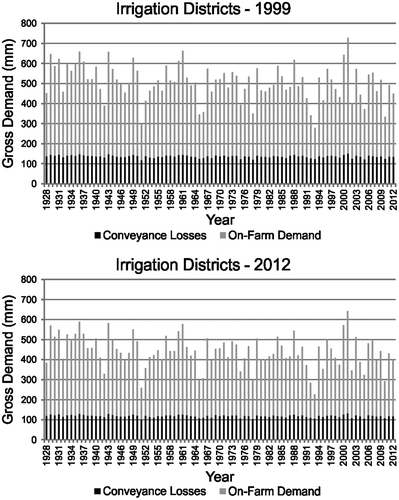
The total licensed water allocation for the irrigation districts, expressed on a depth basis, is about 700 mm based on the irrigated area in 1999 (490,384 ha) and about 660 mm based on the irrigated area in 2012 (520,717 ha). An increase in the irrigated area to the current irrigation district expansion limit of 612,200 ha would result in a total licensed water allocation of about 560 mm. Thus, gross demand under 2012 conditions could approach the total licensed water allocation for the irrigation districts in extremely high-demand years with irrigation expansion.
Demand reductions (volume basis)
Mean on-farm demand expressed on a volume basis ranged from 1.28 billion m3 at a 90% chance of exceedance to 2.33 billion m3 at a 10% chance of exceedance, based on 1999 conditions (Table ). The mean on-farm demand at a 50% chance of exceedance for 1999 was 1.84 billion m3. On-farm demand in the Oldman Basin increased by 30 million m3 at a 90% chance of exceedance to 40 million m3 at chances of exceedance of 50% or less from 1999 to 2012. Demand reductions in the Bow Basin from 1999 to 2012 varied from 140 million m3 at a 90% chance of exceedance to 180 million m3 at chances of exceedance of 25% or less. Overall reductions in on-farm demand in the Oldman and Bow Basins combined ranged from 120 million m3 at a 90% chance of exceedance to 150 million m3 at a 10% chance of exceedance. Differences in on-farm demand between the Oldman and Bow Basins were attributed to the greater expansion area in the Oldman Basin than in the Bow Basin (Table ), and to differences in irrigation system types and crop mixes among the irrigation districts in each basin in 1999 and 2012 (Tables and ).
Table 6. Mean values for on-farm demand, conveyance losses and demand and conveyance loss changes (billion m3) for the irrigation districts in 1999 and 2012 at different chances of exceedance.
Mean conveyance losses on a volume basis ranged from 620 million m3 at a 90% chance of exceedance to 700 million m3 at a 10% chance of exceedance under 1999 conditions (Table ). Demand reductions from 1999 to 2012 were about 10 million m3 for the irrigation districts in the Oldman Basin and 40 million m3 for the irrigation districts in the Bow Basin. Overall, conveyance losses were reduced by about 50 million m3 from 1999 to 2012 through rehabilitation of irrigation infrastructure (Table ) and improved operation of the conveyance system.
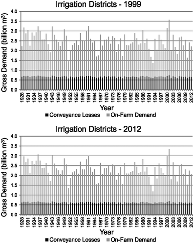
Variability in mean gross demand on a volume basis (Figure ) was similar to gross demand on a depth basis; however, differences from 1999 to 2012 were not as evident, due to the water requirements for irrigation expansion. Overall gross demand at a 90% chance of exceedance was reduced from 1.90 billion m3 in 1999 to 1.73 billion m3 in 2012 (Table ). Gross demand was reduced from 3.03 billion m3 in 1999 to 2.83 billion m3 in 2012 at a 10% chance of exceedance. The mean gross demand at a 50% chance of exceedance of 2.32 billion m3 based on 2012 conditions is greater than the 10-year rolling average target of 2.186 billion m3 in the Alberta irrigation sector plan (Alberta Irrigation Projects Association Citation2010). Overall demand reductions from 1999 to 2012 were about 170 million m3 at a 90% chance of exceedance and increased to 200 million m3 at a 10% chance of exceedance. Differences in gross demand in years of low demand (90% chance of exceedance) compared to years of high demand (10% chance of exceedance) were attributed to the efficiencies of the irrigation systems used to apply greater amounts of irrigation water in high-demand (dry) years. The proportion of demand reductions attributed to decreased on-farm demand ranged from 70% in wet years to 75% in dry years.
Figure 3. Gross irrigation district demand (volume basis) under 1999 and 2012 conditions with weather variability from 1928 to 2012.
Further upgrades to more efficient irrigation systems on about 48,100 ha irrigated with high-pressure centre-pivot systems and on a portion of the 114,800 ha irrigated with wheel-move and gravity irrigation systems (Table ), as well as rehabilitation of the remaining 1632 km of un-rehabilitated water conveyance infrastructure, will provide additional water savings. Use of higher efficiency sprinkler nozzles and variable-rate technologies on low-pressure centre-pivot irrigation systems, as well as improved irrigation management, may also enhance on-farm efficiency gains in the future.
Naturalized flows
Seasonal naturalized flows have varied from about 1.2 to 4.5 billion m3 in the Oldman River Basin and from 2.1 to 6.2 billion m3 in the Bow Basin from 1912 to 2009 (Figure ). Overall naturalized flows in both basins combined have ranged from 3.4 to 10.3 billion m3 during this time interval. A slight downward trend in naturalized flow was detected with time; however, the slopes of these trend lines were extremely low. These trends were not statistically significant at p < 0.05 for the Oldman Basin and both basins combined, but a significant downward trend was detected for the Bow Basin. Rood et al. (Citation2005) examined mean annual discharge from headwater streams in the central Rocky Mountains and found significant flow reductions in 15 of 31 streams. A subsequent study of seasonal flows in 14 river reaches in the same area detected reduced summer and early autumn flows (Rood et al. Citation2008). Flow reductions in both studies were attributed to climate change. Glacier runoff from the eastern slopes of the Rocky Mountains has been estimated as 3 to 4% of mean annual discharge and 7 to 8% of July to September flows in the Bow River at Calgary (Marshall et al. Citation2011). A decline in glacier wastage is expected to result in reduced late-summer streamflows and a long-term decrease in the total annual streamflow volumes (Comeau et al. Citation2009), which is of greatest concern for the Bow River in dry years.
Figure 4. Mean seasonal naturalized flows from 1912 to 2009 in the Oldman River, Bow River and both river basins combined.
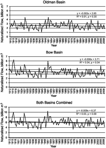
Mean seasonal naturalized flows from 1912 to 2009 based on Monte Carlo simulations were 4.15 billion m3 at a 90% chance of exceedance, 5.88 billion m3 at a 50% chance of exceedance, and 7.90 billion m3 at a 10% chance of exceedance for the Oldman and Bow Basins combined (Table ). Lag1 and lag2 correlations for naturalized flow were not significant in the Oldman Basin and in both basins combined; however, the lag1 correlation of 0.22 for naturalized flow in the Bow Basin was significant at p < 0.05. This low correlation value is considered trivial since only 4% of the variation in naturalized flow in one year can be accounted for by the naturalized flow the previous year, and 96% was unaccounted for.
Table 7. Mean values for naturalized flow (billion m3) in the Oldman and Bow River Basins from 1912 to 2009 at different chances of exceedanceTable Footnotea.
Given the Master Agreement on Apportionment that requires half of the natural flow from Alberta to be passed to Saskatchewan, the seasonal naturalized flows that were available for use in Alberta from 1912 to 2009 ranged from about 2.08 billion m3 at a 90% chance of exceedance to 3.95 billion m3 at a 10% chance of exceedance. The average apportionable flow passed to Saskatchewan was 75% from 1975 to 2001 (Alberta Environment Citation2003) and 81% from 1970 to 2006 (AMEC Citation2009). Surplus deliveries for 1970 to 2006 ranged from 350 million m3 in 2001 to 5.5 billion m3 in 2005 (AMEC Citation2009). Mean gross demand for the irrigation districts from 1976 to 2007 was 2.3 billion m3, with gross demand varying from about 1.4 billion m3 in 1978 to 2.9 billion m3 in 1988 (AECOM Citation2009). Annual gross diversion volumes by the irrigation districts since 2000 have ranged from 1.0 to 2.8 billion m3, with a mean gross diversion volume of about 1.8 billion m3 (Alberta Agriculture and Rural Development Citation2013a).
Seasonal naturalized flows from the rivers and tributaries included in this assessment would provide the total licensed water allocation for the irrigation districts (3.45 billion m3) less than 25% of the time. Water allocations for private irrigation and other licensed uses are about 1.34 billion m3 in the Oldman and Bow River Basins (AMEC Citation2009). Gross demand of the same magnitude as the total licensed allocation for the irrigation districts is anticipated less than 10% of the time (Table ). Unfortunately, the greatest water demand for all licensed uses usually occurs in dry years when river flows are the lowest, so water storage during periods of above-average river flow is a key component of water management in southern Alberta. The live storage capacity of more than 50 storage reservoirs used for water management in Alberta is about 3 billion m3, with about 1.15 billion m3 of that capacity in on-stream reservoirs, and the balance in off-stream reservoirs (Alberta Agriculture and Rural Development Citation2013a). Weekly flows are more important than seasonal or annual flows in some parts of the irrigated area because not all irrigated areas are supported by water storage infrastructure. Seasonal river flows are extremely variable from year to year and often within any given year, so continued improvements in water conveyance and on-farm irrigation efficiencies are essential for the continued growth and sustainability of irrigated agriculture in southern Alberta.
Conclusions
Irrigation districts in southern Alberta achieved substantial reductions in on-farm water demand and conveyance losses from 1999 to 2012. Mean on-farm demand based on the irrigated area at a 10% chance of exceedance was reduced from 474 mm in 1999 to 419 mm in 2012. The mean conveyance losses at a 10% chance of exceedance were decreased from 144 mm in 1999 to 125 mm in 2012. Gross demand at a 10% chance of exceedance was 618 mm based on 1999 conditions and 544 mm with conditions in 2012. Efficiency gains were generally greater in the Bow Basin compared to the Oldman Basin. Reductions in on-farm demand on a volume basis ranged from about 120 million m3 in wet years to 150 million m3 in high-demand years. Conveyance loss reductions were stable at about 50 million m3. Weather variability affected efficiency gains in on-farm demand to a greater degree than conveyance losses, with 70 to 75% of the potential water savings through reduced on-farm demand. Efficiency gains were attributed to extensive on-farm investments in more efficient irrigation systems and irrigation district (cost-shared and district-funded) rehabilitation of water conveyance infrastructure.
Mean seasonal naturalized flows available for use in Alberta from 1912 to 2009 ranged from 2.08 billion m3 at a 90% chance of exceedance to 3.95 billion m3 at a 10% chance of exceedance. Overall gross demand based on 2012 conditions ranged from 1.73 billion m3 in wet years (90% chance of exceedance) to 2.83 billion m3 in high-demand years (10% chance of exceedance). Additional efficiency gains are possible within the irrigation districts through further upgrades to more efficient irrigation systems and continued rehabilitation of water conveyance infrastructure. Prudent use of on-stream and off-stream water storage infrastructure is also essential for the sustainability of the irrigation industry in southern Alberta.
Acknowledgements
Contributions from Don Roth and Bob Winter (irrigation demand modeling), Bonnie Hofer and Brian Coffey (figure preparation), and Jollin Charest (abstract translation) are gratefully acknowledged. Naturalized flow data and advice provided by Werner Herrera, Alberta Environment and Sustainable Resource Development, are also greatly appreciated.
References
- AECOM Canada Ltd. 2009. Irrigation sector – conservation, efficiency, and productivity planning report. Edmonton, AB: AECOM.
- Alberta Agriculture and Rural Development. 2009. Agroclimatic atlas of Alberta: Interpolation of climate station data. Edmonton Alberta: Environmental Stewardship Division.
- Alberta Agriculture and Rural Development. 2011. Irrigation system application efficiency values. Agdex 563-1. Lethbridge, AB: Irrigation and Farm Water Division.
- Alberta Agriculture and Rural Development. 2013a. Alberta irrigation information 2012. Lethbridge, AB: Irrigation and Farm Water Division.
- Alberta Agriculture and Rural Development. 2013b. Alberta irrigation management manual. Lethbridge, AB: Irrigation and Farm Water Division.
- Alberta Environment. 2003. South Saskatchewan River Basin water management plan phase two: Background studies. Edmonton, AB. http://environment.gov.ab.ca/info/library/7884.pdf (accessed April, 2014).
- Alberta Environment and Sustainable Resource Development. 2014. Alberta’s river basins. http://www.environment.alberta.ca/apps/basins (accessed April, 2014).
- Alberta Irrigation Projects Association. 2010. Irrigation sector conservation, efficiency, and productivity plan 2005–2015. Lethbridge, AB. http://www.aipa.ca/wp-content/uploads/2013/11/AIPA-CEP-Final-Version-1.pdf (accessed April, 2014).
- Allen, R. G., T. A. Howell, and R. L. Snyder. 2011. Irrigation water requirements. In Irrigation. 6th ed., ed. L. E. Stetson and B. Q. Mecham, 91–172. Falls Church, VA: Irrigation Association.
- AMEC Earth and Environmental. 2009. South Saskatchewan River Basin (Alberta) water supply project final report. Calgary, AB: AMEC.
- Baker, D., L. Ryan, and K. Kroker. 2002. Deriving irrigation water demands through the Irrigation District Model (IDM). In Irrigation in the 21st Century. Volume 4: Modeling Irrigation Water Management, ed. Irrigation Water Management Study Committee, 1-103. Lethbridge, AB: Alberta Irrigation Projects Association. http://www1.agric.gov.ab.ca/$department/deptdocs.nsf/all/irr4421#CompletedReports (accessed April, 2014).
- Bennett, D. R., and T. E. Harms. 2011. Crop yield and water requirement relationships for major irrigated crops in southern Alberta. Canadian Water Resources Journal 36(2): 159–170.
- Bennett, D. R., T. E. Harms, and T. Entz. 2014. Net irrigation water requirements for major irrigated crops with variation in evaporative demand and precipitation in southern Alberta. Canadian Water Resources Journal 39(1): 63–72.
- Bennett, D. R., R. Heikkila, R. V. Riewe, O. Oyewumi, and T. E. Harms. 2013. Farm economic impacts of water supply deficits for two irrigation expansion scenarios in Alberta. Canadian Water Resources Journal 38(3): 210–222.
- Comeau, L. E., A. Pietroniro, and M. N. Demuth. 2009. Glacier contribution to the North and South Saskatchewan Rivers. Hydrological Processes 23: 2640–2653.
- Food and Agriculture Organization of the United Nations (FAO). 2011. The state of the world’s land and water resources for food and agriculture: Managing systems at risk. Rome, Italy: FAO.
- Godfray, H. C. J., J. R. Beddington, I. R. Crute, L. Haddad, D. Lawrence, J. F. Muir, J. Pretty, S. Robinson, S. M. Thomas, and C. Toulmin. 2010. Food security: The challenge of feeding 9 billion people. Science 327: 812–818.
- Graveline, N., S. Loubier, G. Gleyses, and J.-D. Rinaudo. 2012. Impact of farming on water resources: Assessing uncertainty with Monte Carlo simulations in a global context. Agricultural Systems 108: 29–41.
- Hanjra, M. A., and M. E. Qureshi. 2010. Global water crisis and future food security in an era of climate change. Food Policy 35: 365–377.
- Irrigation Water Management Study Committee. 2002. South Saskatchewan River Basin: Irrigation in the 21st century. Volume 1: Summary report. Lethbridge, AB: Alberta Irrigation Projects Association.
- Jensen, M. E., R. D. Burman, and R. G. Allen. 1990. Evapotranspiration and irrigation water requirements. ASCE Manuals and Reports on Engineering Practice No. 70. New York, NY: American Society of Civil Engineers.
- Maneta, M. P., M. Torres, W. W. Wallender, S. Vosti, M. Kirby, L. H. Bassoi, and L. N. Rodrigues. 2009. Water demand and flows in the Sao Francisco River Basin (Brazil) with increased irrigation. Agricultural Water Management 96: 1191–1200.
- Marshall, S. J., E. C. White, M. N. Demuth, T. Bolch, R. Wheate, B. Menounos, M. J. Beedle, and J. M. Shea. 2011. Glacier water resources on the eastern slopes of the Canadian Rocky Mountains. Canadian Water Resources Journal 36(2): 109–134.
- Nitschelm, J., J. Cordes, B. Riewe, and R. Hohm. 2011. Current irrigation management practices study 2007–2009. Lethbridge, AB: Alberta Agriculture and Rural Development.
- Ring, L., J. Prozniak, R. Renwick, and E. Wilson. 2005. Irrigation infrastructure rehabilitation in Alberta: 35 years of government/industry cooperation. Falls Church, VA: Irrigation Association. https://www.irrigation.org/resources/technicalpaperspp. 451–477 (accessed April, 2014).
- Rood, S. B., J. Pan, K. M. Gill, C. G. Franaks, G. M. Samuelson, and A. Shepard. 2008. Declining summer flows of Rocky Mountain rivers: Changing seasonal hydrology and probable impacts on floodplain forests. Journal of Hydrology 349: 397–410.
- Rood, S. B., G. M. Samuelson, J. K. Weber, and K. A. Wywrot. 2005. Twentieth-century decline in streamflows from the hydrographic apex of North America. Journal of Hydrology 306: 215–233.
- Rubinstein, R. Y., and D. P. Kroese. 2008. Simulation and the Monte Carlo method. 2nd ed. Hoboken, NJ: John Wiley and Sons.
- SAS Institute Inc. 2012. SAS OnlineDoc 9.3. Cary, NC.
- Spank, U., K. Schwarzel, M. Renner, U. Moderow, and C. Bernhofer. 2013. Effects of measurement uncertainties of meteorological data on estimates of site water balance components. Journal of Hydrology 492: 176–189.
- Turral, H., M. Svendsen, and J. M. Faures. 2010. Investing in irrigation: Reviewing the past and looking to the future. Agricultural Water Management 97: 551–560.