
Abstract
Extreme-value statistics has taught us that flood flows can be estimated reasonably well, and that while extreme flows are rare, they are certain to occur. The physical process of flooding is reasonably well understood. However, this knowledge does not extend to steep creeks with potentially highly mobile beds. Most infrastructures on such creeks have been designed for clearwater floods with return periods of up to 200 years. This does not account for hydrogeomorphic processes such as debris floods and debris flows in which parts of, or the entire, channel bed sediments are mobilized and lead to massive erosion of channel bed and banks and debris inundation on terminal alluvial fans. Similarly, the potential for outburst floods – many times larger than normal floods – related to failure of landslide, glacier, moraine, beaver or man-made dams is not systematically included in standard hazard assessments. This paper has the objective of bridging science and practice by highlighting some of the most threatening hydrogeomorphic hazards to which people and infrastructure in mountain regions are exposed, and provides suggestions on how practice can be improved to properly diagnose and analyze the potential for such unusual floods. It is hoped that this will reduce potential losses in spite of the continued encroachment of urban and industrial development into mountain terrain.
Les statistiques de valeurs extrêmes nous a appris que les crues peuvent être estimés raisonnablement bien, et que tandis que les apports extrêmes sont rares, ils sont certains de se produire. Le processus physique d'inondation est raisonnablement bien compris. Cependant, cette connaissance ne s’étend pas aux criques abruptes avec des fonds des canaux potentiellement très mobiles. La plupart des infrastructures sur ces criques a été conçu pour les inondations Clearwater avec des périodes allant jusqu'à 200 années de retour. Cela ne tient pas compte des processus hydrogéomorphiques tels que les inondations torrentielles et coulées de débris dans lequel des parties de, ou l'ensemble, des sédiments du lit du canal sont mobilisées et conduisent à l'érosion massive de lit et des berges canal et des débris des inondations sur les cônes alluviaux terminaux. De même, la possibilité d'inondations éruptives – beaucoup plus importants que les inondations normales – liée à l'insuffisance des glissements de terrain, glacier, moraine, castor ou barrages construits n’est pas suffisamment apprécié. Cet article est dédié à combler science et la pratique en mettant en évidence certains des dangers les plus menaçants hydrogéomorphiques à laquelle les gens et les infrastructures dans les régions de montagne sont exposés, et offre des suggestions sur la façon dont la pratique peut être améliorée pour diagnostiquer et analyser le potentiel de ces inondations inhabituelles correctement. On espère que cela permettra de réduire les pertes potentielles en dépit de l'empiétement continu de développement urbain et industriel en terrain montagneux.
Introduction
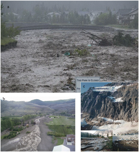
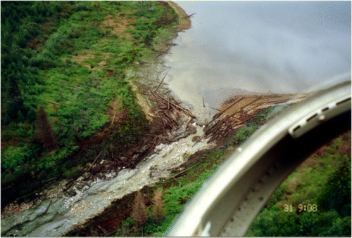
An unusually severe storm in mid-June 2013, in southeastern Alberta, painfully alerted regulators and the public to the risk posed by debris-laden floods in steep mountain creeks within populated areas. Debris floods unleashed by the storm in the southern Rocky Mountains led to economic losses approaching CAD $100 million where the creeks interfaced with infrastructure on their terminal alluvial fans (Figure ). On 13 June 2010, a privately owned earthen dam holding irrigation water near Osoyoos in southern British Columbia failed, causing a torrent of water and debris to flow down Testalinden Creek into a populated area (Figure ). Several homes were destroyed or damaged, and agricultural lands were buried under the debris. During the night of 9 to 10 August 2012, a large mass of ice descended from Ghost Glacier in Jasper National Park, Alberta, into Cavell Tarn, creating a displacement wave that swept downvalley and destroyed some park facilities (Figure ; Quinn et al. Citation2014). Had this event occurred during the day, several people likely would have been killed as the trails near the tarn are popular tourist destinations. While these examples are particularly spectacular, such “unusual” events are by no means rare on a regional scale. These events have all common characteristics that are elaborated below.
Figure 1. (a) Lower Cougar Creek fan at Canmore, Alberta, during the flood on 19 July 2013; in the foreground is the Trans-Canada Highway. Photo by Alpine Helicopters. (b) Debris flow from breached earthen dam at Testalinden Lake, British Columbia. The poorly maintained dam failed after heavy rain in July 2010. Photo by Rick Guthrie. (c) Ice avalanche from former Ghost Glacier and destruction due to debris flood, Jasper National Park. Photo by Parks Canada.
Hydrologists are used to predicting the range of flows likely to occur in a stream channel, by conducting magnitude–frequency analyses on historical flow records. Extrapolations to the largest practically anticipated flow for mitigation design and flood management are then possible (currently, for example, a 1:200 year event is standard practice and mentioned in provincial guidelines in British Columbia). In the absence of flow records for a particular channel, regional records may be used as proxies. The flows that are analyzed are hydrometeorologically driven floods – sometimes referred to as “clearwater floods” to recognize that it is the water flows that are under scrutiny. An implicit assumption is that accompanying sediment delivery does not affect the course of the flood in any singularly important way. This is the manner in which – in most cases – mountain creeks and stream courses with upstream impoundments have been analyzed in Canada. And it is a dangerously wrong thing to do.
“Floods” of the type described above are not conventional hydrometeorological floods at all, although, in the first example (Figure ), the flood was caused by extreme meteorologically generated runoff. Rather, disproportionate volumes of sediment accompanied the flow in each example reported above, and the volumes of water were well beyond what any meteorological event could deliver in the same time period (examples 2 and 3 in Figures and , respectively). These circumstances define the flows as extraordinary events, ones drawn from different populations than conventional floods, the probability for which cannot be analyzed as an extension of clearwater flows. What these floods have in common, then, is exceptional erosive power and the delivery of volumes of water and sediment well beyond what the normal stream channel can accommodate.
Such events in an individual channel are rare. We are used to thinking of the most effective sediment transporting flows in rivers as ones recurring every few years (Wolman and Miller Citation1960); the mean annual flood is often quoted. That is broadly true of larger rivers, but flows capable of moving the characteristically coarse bed material in small, steep channels recur much less frequently – perhaps once every decade to once every few centuries. Beyond the requirement for sufficient water is the condition that there must be a sufficiently large supply of entrainable sediment in the channel to create a significant event. When they occur, such events may be more akin to landslide-like phenomena than to a normal flood; we may call them “hydrogeomorphic events.” (Hydrogeomorphology is an interdisciplinary science that focuses on those geomorphic processes that result from the interaction and linkage of hydrologic processes with landforms and earth materials; see Sidle and Onda [Citation2004].) Outburst floods may not just be rare; they may be unique events in the history of a drainage basin, depending on the nature of the water impoundment from which they arise.
As human activity and settlement push deeper into mountain regions, these non-conventional flows are encountered with increasing frequency. Past and current expansion of resource development and the energy sector in mountain country, including current proposals to construct oil and gas pipelines from Alberta to the Pacific coast, are leading to further research on mountain geohazards. Extreme hydrogeomorphic processes pose a risk to pipelines, highways, rail lines and telecommunication lines that typically follow the sides of valleys and consequently cross torrents and alluvial fans that harbour threats to their integrity. Increasingly, they also threaten urban and industrial developments situated on alluvial fans that appear to be the most attractive, or simply the only feasible, sites for development in some mountain valleys. The first step toward protecting society and its infrastructure from such events is proper recognition of streams that may be subject to them. That is the topic of this paper.
Hydrogeomorphic floods
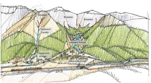
Hydrogeomorphic floods are a phenomenon of steep channels. The morphology and processes in steep channels have been described by Church (Citation2010, Citation2013). Sediment transfer occurs by a continuum of processes ranging from fluvial transport (bedload and suspended load) through “debris floods” to debris flows. These phenomena are transitional within time and space along the channel, depending on the sediment–water mixture. To understand the significance of these different modes of sediment transfer, it is useful to consider the characteristic anatomy of a steep channel system (Figure ). Steep mountain slopes deliver sedimentary debris to the upper channels by rock fall, rock slides, debris avalanches, debris flows, slumps and raveling. Landslides may create temporary dams that pond water: when the dam breaks, a debris flow may be ignited in the channel. Debris flows and debris floods characteristically gain power and material as they move downstream, debouching onto a terminal fan where the channel enters the main valley floor. Here, sediment is deposited and widespread damage may occur.
Figure 2. Schematic diagram of a drainage basin that shows distinctive zones of sediment behaviour and highlights the connectivity of hillslope processes and the channel system for a typical debris-flow prone (left) and debris-flood prone (right) watershed. The alluvial fan is thought of as the long-term storage landform with a time scale of thousands to tens of thousands of years.
Hydrogeomorphic events have been known and studied for more than a century in many parts of the world (Borga et al. Citation2014), and increasingly in Canada since the early 1980s (e.g. Hungr et al. Citation1984). The various modes of sediment transfer in steep channels leave “silent witnesses” in the form of their deposits. These, as well as watershed and channel morphometry, allow researchers to recognize and distinguish the hazard potential that they signal. In this section, the characteristics of steep channels that encourage the generation of debris flows and debris floods are discussed, and the sediment cascade that originates on the steep headwater slopes and ultimately delivers debris to long-term storage on alluvial fans is explained. Debris flows and debris floods are defined and characterized and, finally, the challenges of the co-existence of urban development on alluvial fans and the potentially destructive processes acting on them are elaborated upon.
Hydrogeomorphic processes in mountain channels
Debris flows
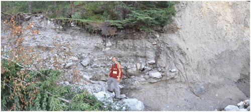
“Debris flow,” as defined by Hungr et al. (Citation2001), is a very rapid, channelized flow of saturated debris containing fines (i.e. sand and finer fractions) with a plasticity index of less than 5%. Debris flows originate from single or distributed source areas in regolith mobilized by the influx of ground- or surface water. Liquefaction occurs shortly after the onset of landsliding due to turbulent mixing of water and sediment, and the slurry begins to flow downstream, entraining additional water and channel debris. Unlike debris avalanches which travel on unconfined slopes, debris flows travel in confined channels bordered by steep slopes. In this environment, the flow volume, peak discharge and flow depth increase, and the debris becomes sorted along the flow path. Debris-flow physics is highly complex and video recordings of events in progress have demonstrated that no unique rheology can describe the range of mechanical behaviours observed (i.e. Iverson Citation1997). Flow velocities typically range from 1 to 10 m/s, although very large debris flows from volcanic edifices, often containing substantial fines, can travel at more than 20 m/s along much of their path (Major et al. Citation2005). The front of the rapidly advancing flow is steep and commonly followed by several secondary surges that form due to particle segregation and upwards or outwards migration of boulders. Hence, one of the distinguishing characteristics of coarse granular debris flows is vertical inverse grading, in which larger particles are concentrated at the top of the deposit. This characteristic behaviour leads to the formation of lateral levees along the channel that become part of the debris flow legacy. Similarly, depositional lobes are formed where frictional resistance from coarse-grained or large organic debris-rich fronts is high enough to slow and eventually stop the motion of the trailing liquefied debris. A typical debris-flow deposit is shown in Figure . Debris-flow deposits remain saturated for some time after deposition, but become rigid once seepage and desiccation have removed pore water.
Figure 3. Example of debris flow deposit interbedded in debris flood deposits at Indian Flats Creek, Canmore, Alberta. Photo by Matthias Jakob.
Typical debris flows require a channel gradient of at least 27% (15°) for transport over significant distances (Takahashi Citation1991), and have volumetric sediment concentrations in excess of 50%. Between the main surges, a fluid slurry with a hyperconcentration (> 10%) of suspended fines occurs. Transport is possible at gradients as low as 20% (11°), although some type of momentum transfer from side-slope landslides is needed to sustain flow on those slopes. Debris flows may continue to run out onto lower gradients even as they lose momentum and drain: the higher the fines content, and hence the slower the sediment–water mixture loses its water content, the lower the ultimate stopping angle. The silt–clay fraction is thus the most important textural control on debris-flow mobility. The surface gradient of a debris-flow fan approximates the stopping angle for flows issuing from the drainage basin.
Due to their high flow velocities, peak discharges at least an order of magnitude larger than those of comparable return-period floods, and the large calibre of transported sediment and wood, debris flows are highly destructive along their channels and on fans. Channel banks can be severely eroded during debris flows, although lateral erosion is often associated with the trailing hyperconcentrated flow phase that is characterized by lower volumetric sediment concentrations. The most severe damage may result from direct impact of large clasts or coarse woody debris against structures that are not designed for the impact forces. Even where building supporting walls may be able to withstand the loads associated with debris flows, windows and doors are crushed and debris may enter the building, leading to extensive damage to the interior of the structure (Jakob et al. Citation2011).
Avulsions are likely in poorly confined channel sections, particularly on the outside of channel bends where debris flows tend to superelevate. Sudden loss of confinement and decrease in channel slope cause debris flows to decelerate, drain their inter-granular water and increase shearing resistance, which slow the advancing bouldery flow front and block the channel. The more fluid afterflow (hyperconcentrated flow) is then often deflected by the slowing front, leading to secondary avulsions and the creation of distributary channels on the fan. Since debris flows often display surging behaviour, in which bouldery fronts alternate with hyperconcentrated afterflows, the cycle of coarse bouldery lobe and levee formation and afterflow deflection can be repeated several times during a single debris-flow event. These flow aberrations and varying rheological characteristics pose a particular challenge to numerical modelers seeking to create an equivalent fluid (Iverson Citation2014).
Debris floods
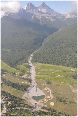
A “debris flood” is “a very rapid surging flow of water heavily charged with debris in a steep channel” (Hungr et al. Citation2001, 233). Transitions from water flows to debris floods occur at minimum volumetric sediment concentrations of 3 to 10%, the exact value depending on the particle size distribution of the entrained sediment and the ability to acquire yield strength. Since debris floods are characterized by heavy bedload transport, rather than by a more homogenous mixture of suspended sediments typical of hyperconcentrated flows (Pierson Citation2005), the exact definition of sediment concentration depends on how sediment is transported in the water column. Debris floods typically occur on creeks with channel gradients between 5 and 30% (3–17°). Figure is an example of a recent debris flood at Three Sisters Creek, Canmore.
Figure 4. Debris flood deposit and erosion on Three Sisters Creek, Canmore, from the 19–21 June 2013 storm over southeastern Alberta. Photo by Matthias Jakob.
Due to their higher volumetric water concentration, debris floods are more erosive along channel banks than debris flows; the latter can reach a sediment saturation point whereby bank erosion is significantly reduced. Bank erosion and excessive amounts of bedload introduce large amounts of sediment to the fan where they accumulate (aggrade) in channel sections with decreased slope. Because storm hydrographs typically fluctuate several times during a given storm, several cycles of aggradation and remobilization of deposited sediments on channel and fan reaches can be expected.
The interplay between channel bank erosion and channel bed aggradation can lead to avulsions where the channel becomes unconfined on its alluvial fan. Erosion and avulsion are generally responsible for the majority of damage associated with a debris flood, in contrast to losses due to direct boulder impact inflicted by debris flows. The debris-flood events of 2013 on fans along the Bow River Valley between Banff and Seebe provide ample proof of the damage potential of debris floods (Jakob et al. Citation2014).
The alluvial fan problem
Lack of recognition of the hazards posed by these steep creek processes has repeatedly led to costly disasters in Canada, almost entirely on the terminal alluvial fans, fortunately with relatively minor loss of life (Hungr Citation2004). Here, the principal issues that underlie the problem that emerges when development encroaches on alluvial fans are highlighted.
Active alluvial fans are highly dynamic landforms, which is attributable to the arrival of debris flows and debris floods with their attendant sediment deposition, bank erosion and possible avulsions – processes that can “rearrange” a fan’s topography within the course of a single event. These processes lead to inherent instability of the water courses crossing fans. Such instability does not cease when channels are deepened to increase conveyance and to allow development to encroach on the stream channel.
Channelization, which is achieved by channel deepening and/or bank protection, is commonly undertaken to facilitate development on fans, but it can destabilize the channel: channel gradient, flow depth and flow velocity increase, all of which increase shear stress acting on the channel bed and banks, thus exacerbating erosion and channel widening. On low-gradient fans, aggradation of sediment in channelized reaches can render bank protection dysfunctional: the channel may fill, reducing flow confinement and possibly leading to avulsion with consequent damage in urbanized locations. Material recruited in upper fan reaches is commonly deposited in lower fan reaches, leading to avulsions that affect the distal fan. Thus, when humans interfere with channels on developed alluvial fans, they must address all system components, typically at a significant cost.
Culverts and bridges on alluvial fans typically are designed for clearwater floods. Such floods will occur up to some flow depth at which associated shear forces mobilize increasingly large amounts of sediment and evolve into debris floods. Culverts, which are almost always points of flow confinement and sediment deposition, fill with debris, rendering them ineffective to convey the design water flows. Ignoring the potential for high rates of sediment transport and deposition on the fan inevitably leads to failure of undersized stream-related infrastructure.
Event diagnoses
Numerous tools have been developed to quantify debris-flow hazards on fans. Guidance for translating scientific findings into hazard and risk assessments, especially in western Canada, is provided, for example, by Hungr et al. (Citation1984), VanDine (Citation1985), Jackson et al. (Citation1987), Bovis and Dagg (Citation1992), Bovis and Jakob (Citation1999), Jakob and Jordan (Citation2001), Wilford et al. (Citation2004), Jakob and Hungr (Citation2005), Jakob et al. (Citation2011) and many others (see bibliography of Canadian subaerial debris flows by VanDine [Citation2000]).
Creeks prone to debris flows and debris floods can be identified using a variety of field and desktop methods. Initially, examination of the basin morphometry, especially the basin roughness and slopes (Jackson et al. Citation1987; Wilford et al. Citation2004), allows preliminary differentiation of debris flow and debris flood-prone channels with rougher and steeper slopes being more prone to debris flows. These tools can be applied numerically based on adequate watershed topography and are particularly helpful when applied to infrastructure such as roads, railways, powerlines or pipelines that cross a large number of stream channels, of which the most hazardous must to be identified. In the field, where definitive determination should always be made, silent witnesses in the form of boulder lobes, levees flanking the stream channels, natural or artificial exposures of fan stratigraphy, and boulder-impacted trees above the channel bed all provide indications of the types of event that have occurred on a creek (Jakob Citation2005).
The key to a successful reconstruction of debris flows and debris floods, and thus construction of a reliable frequency–magnitude relation for those events, lies in the application of multiple diagnostic techniques. Depending on the physiographic setting of the study site, the techniques might include, in order of increasing date range, historic accounts, air photograph or satellite image interpretation and analysis, dendro-geomorphic methods, test trenching for stratigraphic logging, and dating of organics deposited within debris-flow or debris-flood deposits or paleosols. These techniques can be supplemented by an empirical relation between net sediment deposited on fan surfaces and the effective runoff, and sometimes average creek gradient, as identified by Rickenmann and Koschni (Citation2010) and validated during recent work in the Bow Valley, Alberta, by Jakob et al. (Citation2014).
Debris flow and debris flood magnitudes can be reconstructed through application of the same methods that are used to decipher event frequencies. Empirical relations between areas inundated by debris flows or debris floods and their respective thicknesses allow estimates of volume to be made (Griswold and Iverson Citation2014). Correlation of dated deposits between test trenches can provide three-dimensional resolution of the fan’s architecture and estimates of event volumes (Jakob Citation2005, Citation2013). Where only peak discharges can be measured, and the associated debris deposits have been eroded or obliterated, empirical relations between peak flows and debris flow volumes may help constrain the latter (Mizuyama et al. Citation1992; Jakob and Bovis Citation1996; Rickenmann Citation1999). In cases where debris flows or debris floods discharge into lakes, varve chronologies may help decode events of the past.
Hydrogeomorphic hazard and risk assessments cannot rely solely on studies of fans. Fans and watersheds are coupled both geomorphologically and hydrologically. Hillslope processes that feed sediment into the main channels are key to understanding sediment transfers and causal chains such as those stemming from natural damming events. In addition to desktop studies of the watersheds, important insight can be garnered through channel traverses on foot.
Tributaries and main valley rivers are coupled. Main valleys define the base level of tributaries and thus, to some degree, influence the gradients of the latter, which in turn determine sediment movement rates and modes. Changes in the trunk river due to upstream or downstream damming or changes in its sediment load or alignment can lead to changes in the tributary (e.g. Ayles and Church Citation2015). Floods in the main valley can erode and thus truncate tributary fans, shortening tributary fan length and oversteepening the channel on the fan. This cascade of events can erode a portion of the fan that previously was a depositional environment. Sediment retention structures or water reservoir dams near or upstream of the fan apex and channel stabilization measures will lead to significantly reduced sediment input to the main valley stream, which can alter the stream’s planform at and downstream of the confluence (Ferguson and Hoey Citation2008). These changes could also affect aquatic ecosystems on which fish and other fauna depend (Gore Citation2001). These possibilities highlight the importance of adding fluvial geomorphic and perhaps ecological components to fan hazard and risk studies.
Numerous nuances and deviations from normal stream channel or fan behaviour exist, but the issues listed above provide some insight into commonly ignored situations. The morphodynamics of alluvial fans must be understood and quantified before engineering measures are chosen and development is allowed to proceed.
Outburst floods
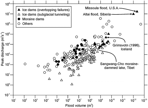
Several geological processes lead to impoundment of water bodies that can rapidly drain to cause large floods or debris flows. The peak discharges of these floods greatly exceed those of the largest floods generated by rainfall or snowmelt in the same watershed, in some instances by a factor of 100 (O’Connor et al. Citation2013). Outbreak flood volume and peak discharge are correlated, which allows an estimation of hazard downstream in case of an outbreak as the impoundment volume can be measured (Figure ) (Clague and O’Connor Citation2014). Although of short duration, outburst floods can have profound and long-lasting geomorphic effects because they typically inundate landscapes unadjusted to such flows. In the following sections, outburst floods are considered from a spectrum of lakes impounded by a variety of natural dams.
Figure 5. Outburst floods for which volume and peak discharge are known. Several of the largest floods are labeled. Adapted with permission from Clague and O’Connor (Citation2014, Fig. 14.1).
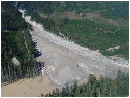
Landslide dam outbursts
Landslide dams (Figure ) are produced by mass movements of rock or sediment that block stream channels. Even small blockages can pose a serious hazard and risk both upstream and downstream of the dam. Landsliding directly into lakes can trigger large waves that overtop dams or outlets, causing large downstream floods. Examples include Haney in 1980 (Fraser River), Spences Bridge in 1905 (Thomson River), Mount Colonel Foster (1946), Pandemonium Creek (1959) and Chehalis Lake (2007).
Figure 6. Lake impounded behind a landslide dam in Meager Creek valley, British Columbia, in July 1998. Before it emptied, the lake was up to 1 km long and approximately 10 m deep at the dam. The lake drained non-catastrophically by overtopping and incision of the dam. Photo by Dave Steers.
Flood waves generated by such events can have peak discharges in excess of the hydrologically determined peak flows for a 100- or 200-year return period event (i.e. Jakob and Jordan Citation2001). They may transform into debris flows if the lake outlet or downvalley channel is sufficiently steep. Of particular interest are landslides into artificial reservoirs in Canada’s mountain regions. Some sites of concern are very well known and have been studied for many decades, for example the Downie Slide at the margin of Lake Revelstoke in the Columbia River valley (Blown Citation1966; Piteau et al. Citation1978). This issue has surfaced in connection with the proposed Site C dam in the Peace River valley, where landslides and landslide dams have been recognized (Evans et al. Citation1996; Fletcher et al. Citation2002). Landslide dams are especially common in northwestern Alberta and northeastern British Columbia, where landslides in clayey glaciolacustrine, till and Cretaceous shales are common (Geertsema et al. Citation2006).
While landslide dams on large rivers are short-lived, commonly surviving from hours to a few days, those on small streams may survive for decades. A landslide in glacial sediments in central British Columbia blocked Chilcotin River, an important tributary of Fraser River, for one day in August 2004. The dip and spike in the Chilcotin and Fraser River hydrographs were traced downstream 400 km to near Vancouver. Fraser River itself has likely been dammed several times during the Holocene. A well-documented example is damming of the river by a rockslide at Texas Creek, located between the towns of Lytton and Lillooet (Ryder et al. Citation1990). Even though failures from landslide dams of this scale are rare, their consequences, especially for one on the lower Fraser River, would be dramatic.
Most landslide dams are vulnerable to breaching because they consist of mechanically weak, porous earth materials; they also have no controlled outlets. Overtopping, earthquakes, groundwater piping or collapse of the blockage itself are the causes of most dam failures. Finally, some breaches are triggered by large waves that overtop the dam.
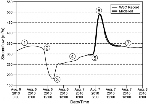
Generally, landslide dams are gradually incised. Nevertheless, flood volumes can be large and can be detected on hydrographs over long distances. Two examples are the 1998 and 2010 blockages of Meager Creek in the southern Coast Mountains of British Columbia (Bovis and Jakob Citation2000; Guthrie et al. Citation2012). Lakes impounded upstream of the 1998 and 2010 debris dams gradually incised the barriers without causing flooding, but spikes in the hydrograph of Lillooet River were observed 58 km downstream in the community of Pemberton, as shown for the 2010 event in Figure .
Figure 7. Hydrograph of Lillooet River at Pemberton, showing the reduction and then spike of flow caused by the 2010 Mount Meager landslide. The landslide temporarily stemmed the flow of both Meager Creek and Lillooet River. Reproduced with permission from Guthrie et al. (Citation2012). WSC: Water Survey of Canada.
It is difficult to predict the stability of landslide dams, given the number of factors at play. Quantitative indices based on morphometric and watershed characteristics, including dam height and volume, impounded water volume, and watershed area and relief, have been used successfully in some areas to discriminate stable from unstable dams, but their predictive power is low (Korup Citation2004).
Glacier dam and ice-jam outbursts
Sudden emptying of lakes impounded by glaciers has produced the largest freshwater floods on Earth (O’Connor and Costa Citation2004) and has profoundly affected landscapes they have crossed. Valley-blocking ice dams are now restricted to mountain areas and polar regions; in Canada, glacier-dammed lakes are found in the glacier-clad mountains of British Columbia, Alberta, and on some of the Arctic islands of Nunavut.
Relations among valley-blocking ice, the landscape and impounded water are complex; consequently, there are a variety of stable and unstable scenarios and different failure mechanisms. In some cases, a cycle of repeated sudden lake emptying followed by refilling happens over a period of years to decades (Marcus Citation1960).
Water can escape from glacier-dammed lakes by overtopping or by flowing through subglacial or englacial tunnels and cavities. Most commonly, ice-dammed lakes drain via subglacial tunnels. The tunnels enlarge by both thermal and mechanical erosion, but can narrow or even close during the flood by cryostatic pressure and ice deformation, especially beneath thick glaciers. The largest and most lethal glacier outburst floods are “sudden break” outbursts, involving non-tunnel lake drainage (Haeberli Citation1983; Walder and Costa Citation1996). They typically involve rapid mechanical failure of the ice dam. A recent such example occurred in the Rocky Mountains of eastern British Columbia in July 2014, when a large (40,000 m3) mass of Cathedral Glacier detached and released water that had been stored in a supraglacial and likely linked subglacial lake upstream.
Moraine dam outbursts
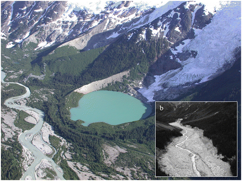
Moraine-dammed lakes occupy valleys or basins blocked by lateral or end moraines (Figure ). Releases of water from moraine-dammed lakes are sudden and rapid, producing impressive floods far from their source (Figure ). Moraine dams have become a subject of particular interest because of recent climate warming. Most moraine dams that have breached in recent decades formed prior to the nineteenth century when alpine glaciers achieved their greatest extent of the Holocene Epoch (a time referred to as the “Little Ice Age”). Through most of the twentieth century, glaciers retreated from their advanced Little Ice Age positions, allowing lakes to form in the space between moraines and the retreating ice (Clague and Evans Citation2000).
Figure 8. (a) An unnamed moraine-dammed lake in the southern Coast Mountains of British Columbia. The moraine was constructed by a small valley glacier during the Little Ice Age. A lake formed in the basin created when the glacier retreated from the moraine during the early 1900s. Photo by John J. Clague. (b) Flood-ravaged valley floor of a tributary of Nostetuko River, British Columbia, following the catastrophic draining of a moraine-dammed lake in July 1997. Photo by John J. Clague.
Many moraine dams are susceptible to breaching because of their physical characteristics and trigger mechanisms provided by the adjacent steep terrain. Little Ice Age moraines are sparsely vegetated and consist of loose and poorly sorted sediment lying on steep slopes – these characteristics facilitate rapid erosion and breaching if the moraine is overtopped. Breaching can be triggered by overflow and outlet erosion during periods of rapid snowmelt or heavy rainfall. Failure most commonly occurs, however, when ice avalanches or rock-fall enter the lake and generate waves that overtop the moraine and initiate erosion (e.g. Blown and Church Citation1985). Breaching in some cases may be facilitated by a slow lowering of the moraine crest due to melting of ice cores or interstitial ice.
Beaver dam outbursts
Beaver (Castor canadensis) dams and resulting ponds were widespread and common in forested areas throughout North America prior to trapping, which began late in the seventeenth century. Over the past century, beavers have returned in large numbers to their former habitats and beaver-dammed ponds are becoming more common.
Beavers construct dams of sticks and mud, and continuously repair them as breaches develop. Dams are abandoned and prone to failure after local food supplies are exhausted, usually 6 to 10 years after the dams are built (Geertsema and Clague Citation2008). Beaver dam failures cause minor washouts that plague highways and rail lines, and are the principal hazard that affects pipeline crossings. Where beavers dam the outlet streams of lakes, failures can be catastrophic. Butler and Malanson (Citation2005) compiled information on several outbreak floods, including four that resulted in fatalities. In most cases, damage and geomorphic consequences are localized because of the small sizes of the dams and impoundments. An exception is a flood with a peak discharge of 15 m3s−1 caused by breaching of a beaver dam in Alberta (Hillman Citation1998). This flood greatly exceeded meteorological floods in the watershed. Case et al. (Citation2003) documented another large outbreak flood caused by the failure of a beaver dam. The outlet of Chudnuslida Lake (60 ha) near Prince George, British Columbia, had been raised 2 m by beavers (Figure ). When the dam failed, about 2 million m3 of water escaped from the lake and eroded the channel of the outlet stream to a depth of up to 4 m over a distance of 4 km. The flood caused considerable bank erosion and secondary slope failures along the stream channel.
Figure 9. Eroded channel of outlet stream flowing from Chudnuslida Lake following an outbreak flood in 2000. The outbreak resulted from failure of a beaver dam (top of photo). Photo by Marten Geertsema.
Constructed dam outbursts
Floods from artificial reservoirs pose a significant hazard and can accomplish substantial geomorphic work. Jansen (Citation1980) reported over 2000 failures of constructed dams since AD 1100, resulting in more than 11,000 fatalities. At least four constructed dam failures since 1889 have claimed more than 2000 lives; the 1975 failure of Banqiao dam on the Ru River, China, drowned 26,000 people and claimed an additional 145,000 lives from famine and disease (Si Citation1998).
Most constructed dams are made of compacted fill and rock; other types are concrete or masonry structures that rely on gravity, buttresses and arch-shaped planforms to counter the pressure of the reservoir water mass. Tailings dams, which are embankments for storing mill byproducts and waste rock produced during mining, are another class of dams with significant outburst flood potential (Rico et al. Citation2008). A recent example of a tailings dam failure is the Mount Polley mine failure in central British Columbia on 4 August 2014.
The most destructive dam failures in Canada occurred in July 1996, during a period of exceptionally heavy precipitation in the Saguenay region of Quebec. Many dams failed, exacerbating flooding that damaged over 60 communities in the region. About 16,000 people were evacuated and damages exceeded CAD $700 million.
Discussion
Hydrogeomorphic hazard and risk assessments of alluvial fans are inherently multidisciplinary. They may require expertise in hydrology, fluvial geomorphology, Quaternary geology, paleoflood analysis, engineering geology, numerical modeling techniques for Newtonian and non-Newtonian fluids, and specialty skills such as dendrochronology, radiometric dating and paleolimnology. Study teams must possess a breadth of knowledge to extract the maximum information afforded by a drainage basin and its terminal fan. These studies are the cornerstone on which development and risk reduction decisions must be made. In most cases, their costs are a small fraction of the value of the development under consideration and, by extension, the total loss potential.
Economic losses from hydrogeomorphic disasters stem, in part, from misinterpretation or ignorance of the dominant geomorphic process, or from failure to recognize the possibility of rare events such as outburst floods. Nonetheless, in some cases, especially those characterized by a complex chain of events, it may be difficult, or almost impossible, to forecast damaging extreme events. The 2012 Ghost Glacier event on Mount Edith Cavell in Jasper National Park is an example that fortunately happened at night when there were no visitors in the area. Forecasting such event cascades, especially in the absence of known precursors, is fraught with difficulty and depends on the investigator’s familiarity with each process and their respective interactions, and involves a significant amount of informed geo-scientific imagination. Moreover, one is obligated to consider the impacts of a future warmer climate on the frequency and magnitude of the types of events described in this paper – impacts that may be rather indirect in many cases.
Management of land subject to hazardous hydrogeomorphic events could involve:
| • | determining whether the fan is active at present (i.e. is the stream shallowly incised and subject to frequent changes in course, or is it deeply incised into a paleo-fan surface); | ||||
| • | determining how the fan has evolved over time, and performing desktop studies and field work to identify all processes acting in the drainage basin and on the stream in question; | ||||
| • | searching for signs of unusual events such as debris flows, debris floods and outburst floods and, when found, applying a frequency–magnitude analysis appropriate to those events rather than the standard (“clearwater”) flood frequency analysis; | ||||
| • | considering sediment accumulation, rather than peak water flows, when designing culverts, bridges and other structures near or over water courses; | ||||
| • | understanding the relations among steep creeks, their watersheds, base-level changes, knickpoints and fan channel characteristics; and | ||||
| • | seeking training opportunities offered through workshops and conferences focused on hydro-geomorphic extremes, and seeking interactions and collaborations with research scientists. | ||||
Past destructive hydrogeomorphic events have motivated the Province of British Columbia to elaborate guidelines on floods that include hydrogeomorphic events (Association of Professional Engineers and Geoscientists of British Columbia [APEGBC] Citation2012). Similar guidelines are under review by the Province of Alberta. Incorporation of such guidelines into everyday geoscience and engineering practice is essential in the future to allow development to proceed safely in mountain terrain and, where necessary, to restrict development of hazardous lands where the cost of risk reduction might be disproportional to the benefits that development provides.
Major research efforts to better understand sedimentation processes in mountain streams are pursued in Switzerland, Austria and Italy – alpine countries with extensive settlements and infrastructure within mountains. There is no comparable focus on mountain streams in Canada. Knowledge created by academics and consultants alike is not routinely disseminated amongst practitioners, and it is up to the practitioner as well as municipal engineers who make decisions on development in mountain areas to inform themselves about scientific advances. The events of June 2013 in the Bow Valley have led governments in Alberta to change stream management and development policies. The Town of Canmore and the Municipal District of Bighorn, which suffered the greatest losses among the mountain communities in 2013, have commissioned studies of the hazards and risks of debris floods and debris flows within their jurisdictions, while the Alberta Ministry of Sustainable Resource Development is working on a Guideline for Steep Creek Risk Assessment that will be published in 2015.
It is only a matter of time until an event similar to the 2013 Alberta floods, debris floods and debris flows occurs in a different mountain area in Canada, and similar damages can be expected where the geomorphic effects reach infrastructure or homes. More often than not, development in mountain valleys is concentrated on alluvial fans that offer surfaces elevated above the level of flood-prone main valley streams. Both the developer and the municipality perceive such developments as beneficial. However, their interests in development can conflict with the obligation of local governments to protect citizens from harm stemming from geohazards. Conceptually, a wise balance should be achievable between development and maintenance of an acceptable level of risk through geohazard study and engineering. This balance can only be achieved, however, if local governments have access to sufficient resources and expertise to solicit and implement recommendations from practitioners. In our experience, municipal engineers and planners often lack the required background in geohazards to evaluate proposed developments in potentially hazardous settings. Furthermore, most municipalities in Canada do not have the required resources to mitigate geohazard risks. Consequently, senior governments must step in to both mandate appropriate studies and provide resources for implementing recommendations.
References
- Association of Professional Engineers and Geoscientists of British Columbia (APEGBC). 2012. Guidelines for legislated flood assessments in a changing climate. Vancouver, BC: APEGBC.
- Ayles, C. P., and M. Church. 2015. Chapter 4: Tributary channel gradation due to regulation of Peace River. In The regulation of Peace River, ed. M. Church, 67–88. Chichester, UK: Wiley-Blackwell.
- Blown, I. G. 1966. A geological investigation of the Downie Slide near Revelstoke, British Columbia. BASc thesis, University of British Columbia, Vancouver, BC.
- Blown, I. G., and M. Church. 1985. Catastrophic lake drainage within the Homathko River Basin, British Columbia. Canadian Geotechnical Journal 22: 551–563.
- Borga, M., M. Stoffel, L. Marchi, F. Marra, and M. Jakob. 2014. Hydrogeomorphic response to extreme rainfall in headwater systems: Flash floods and debris flows. Journal of Hydrology 518: 194–205.
- Bovis, M. J., and B. R. Dagg. 1992. A model for debris accumulation and mobilization in steep mountain streams. Journal of Hydrological Sciences 33: 589–604.
- Bovis, M. J., and M. Jakob. 1999. The role of debris-supply conditions in predicting debris-flow activity. Earth Surface Processes and Landforms 24: 1039–1054.
- Bovis, M. J., and M. J. Jakob. 2000. The July 29, 1998, debris flow and landslide dam at Capricorn Creek, Mount Meager volcanic complex, southern Coast Mountains, British Columbia. Canadian Journal of Earth Sciences 37: 1321–1334.
- Butler, D. R., and G. P. Malanson. 2005. The geomorphic influences of beaver dams and failures of beaver dams. Geomorphology 71: 48–60.
- Case, B., P. Egyir, and M. Geertsema. 2003. Catastrophic failure of a beaver dam at Chudnuslida Lake, east central British Columbia. In Geohazards 2003. Third Canadian Conference on Geotechnique and Natural Hazards, 9–10 June 2003. Edmonton, AB: Canadian Geotechnical Society, 85–89.
- Church, M. 2010. Chapter 2: Mountains and montane channels. In Sediment cascades, ed. T. Burt and R. Allison, 17–53. Oxford: Wiley-Blackwell.
- Church M. 2013. Steep headwater channels. In Treatise on Geomorphology, Vol 9, Fluvial Geomorphology, ed. John F. Shroder (Editor-in-chief), E. Wohl (Volume Editor), 528–549. San Diego, CA: Academic Press.
- Clague, J. J., and S. G. Evans. 2000. A review of catastrophic drainage of moraine-dammed lakes in British Columbia. Quaternary Science Reviews 19: 1763–1783.
- Clague, J. J., and J. E. O’Connor. 2014. Chapter 14: Glacier-related outburst floods. In Snow and ice-related hazards, risks, and disasters, ed. W. Haeberli and C. Whiteman, 487–519. Amsterdam: Elesevier.
- Evans, S. G., X.-Q. Hu, and E. G. Enegren. 1996. The 1973 Attachie Slide, Peace River Valley, near Fort St. John, British Columbia, Canada: A landslide with a high-velocity flowslide component in Pleistocene sediments. In Landslides, Glissements de Terrain, Vol. 2: Proceedings of the 7th International Symposium, ed. K. Senneset, 715–720. Rotterdam: A.A. Balkema.
- Ferguson, R., and T. Hoey. 2008. Chapter 10: Effects of tributaries on main channel geomorphology. In River confluences, tributaries and the fluvial network, ed. S. Rice, A. G. Roy and B. L. Rhoads, 183–208. Chichester, UK: John Wiley & Sons.
- Fletcher, L, O. Hungr, and S. G. Evans. 2002. Contrasting failure behaviour of two large landslides in clay and silt. Canadian Geotechnical Journal 39: 46–62.
- Geertsema, M., J. J. Clague, J. W. Schwab, and S. G. Evans. 2006. An overview of recent large catastrophic landslides in northern British Columbia, Canada. Engineering Geology 83: 120–143.
- Geertsema, M., and J. J. Clague. 2008. Natural dams, temporary lakes, and outburst in western Canada. In Proceedings of the First World Landslide Forum. International Program on Landslides, Tokyo, 211–214.
- Gore, J. A. 2001. Models of habitat use and availability to evaluate anthropogenic changes in channel geometry. In Geomorphic processes and riverine habitat, Water science and application. vol. 4, ed. J. M. Dorava, D. R. Montgomery, B. B. Palcsak and F. A. Fitzpatrick, 27–36. Washington, DC: American Geophysical Union.
- Griswold, J. P., and R. M. Iverson. 2014. Mobility statistics and automated hazard mapping for debris flows and rock avalanches. United States Geological Survey, Scientific Investigations Report 2007-5276 Version 1.1, 90 pp.
- Guthrie, R. H., P. Friele, K. Allstadt, N. Roberts, S. G. Evans, K. B. Delaney, D. Roche, et al. 2012. The 6 August 2010 Mount Meager rockslide-debris flow, Coast Mountains, British Columbia: Characteristics, dynamics, and implications for hazard and risk assessment. Natural Hazards and Earth Systems Sciences 12: 1–18.
- Haeberli, W. 1983. Frequency and characteristics of glacier floods in the Swiss Alps. Annals of Glaciology 4: 85–90.
- Hillman, G. 1998. Flood wave attenuation by a wetland following a beaver dam failure on a second order boreal stream. Wetlands 18(1): 21–34.
- Hungr, O. 2004. Landslide hazards in BC. Achieving balance in risk assessment. Innovation. April: 12–15.
- Hungr, O., S. G. Evans, M. J. Bovis, and J. N. Hutchinson. 2001. A review of the classification of landslides of the flow type. Environmental and Engineering Geoscience 7: 221–238.
- Hungr, O., G. C. Morgan, and R. Kellerhals. 1984. Quantitative analysis of debris torrent hazards for design of remedial measures. Canadian Geotechnical Journal 21: 663–677.
- Iverson, R. 1997. The physics of debris flows. Reviews of Geophysics 35: 245–296.
- Iverson, R. 2014. Debris flows: Behaviour and hazard assessment. Geology Today 30 (1): 15–20.
- Jackson, L. E., R. A. Kostaschuk, and G. M. MacDonald. 1987. Identification of debris flow hazard on alluvial fans in the Canadian Rocky Mountains. In Debris flows/avalanches: Process, recognition, and mitigation. Reviews in engineering geology 7, ed. J. E. Costa and G. F. Wieczorek, 115–124. Boulder, CO: Geological Society of America.
- Jakob, M. 2005. Debris flow hazard assessments. In Debris-flow hazards and related phenomena, ed. M. Jakob and O. Hungr, 411–443. Berlin: Springer.
- Jakob, M. 2013. Events on fans and cones. Recurrence interval and magnitude. In Dating methods on alluvial fans and debris cones, ed. M. Schneuwly-Bollschweiler, M. Stoffel, and F. R.-M. Miklau, 95–108. Dordrecht: Springer Science and Business Media.
- Jakob, M., and M. J. Bovis. 1996. Morphometric and geotechnical controls of debris-flow activity, southern Coast Mountains, British Columbia. Zeitschrift für Geomorphologie, Supplement 104: 13–26.
- Jakob, M., and O. Hungr, ed. 2005. Debris flows and related phenomena. Berlin: Springer.
- Jakob, M., and P. Jordan. 2001. Design flood estimates in mountain stream: The need for a geomorphic approach. Canadian Journal of Civil Engineering 28: 425–439.
- Jakob, M., D. Stein, and M. Ulmi. 2011. Vulnerability of buildings to debris flow impact. Natural Hazards 60: 241–261.
- Jakob, M., H. Weatherly, A. Perkins, S. Bale, and J. Sorensen. 2014. Hydro-geomorphic response to the June 19–21, 2013 storm in Canmore and the Municipal District of Bighorn, Alberta. Paper presented at Geohazards 6, Canadian Geotechnical Society Conference, Kingston, ON, June 15–18.
- Jansen, R. B. 1980. Dams and public safety. Washington, DC: US Department of the Interior.
- Korup, O. 2004. Geomorphometric characteristics of New Zealand landslide dams. Engineering Geology 73: 13–35.
- Major, J. J., T. C. Pierson, and K. M. Scott. 2005. Debris flows at Mount St. Helens, Washington USA. In Debris flow hazards and related phenomena, ed. M. Jakob and O. Hungr, 685–731. Heidelberg, Springer-Praxis.
- Marcus, M. 1960. Periodic drainage of glacier-dammed Tulsequah Lake, British Columbia. Geographical Review 50: 89–106.
- Mizuyama, T., S. Kobashi, and G. Ou. 1992. Prediction of debris flow peak discharge. Interpraevent 4: 99–108.
- O'Connor, J. E., J. J. Clague, J. S. Walder, V. Manville, and R. A. Beebee. 2013. Outburst floods. In Treatise on Geomorphology, Vol 9, Fluvial Geomorphology, ed. John F. Shroder (Editor-in-chief), E. Wohl (Volume Editor), 475–510. San Diego, CA: Academic Press.
- O’Connor, J.E., and J. E. Costa. 2004. The world’s largest floods, past and present: Their causes and magnitudes. US Geological Survey Circular 1254.
- Pierson, T. C. 2005. Hyperconcentrated flow: Transitional process between water flow and debris flow. In Debris flow hazards and related phenomena, ed. M. Jakob and O. Hungr, 159–202. Berlin: Springer.
- Piteau, D. R., F. H. Mylrea, and I. G. Blown. 1978. The Downie slide, Columbia River, British Columbia. In Rockslides and avalanches, ed. B. Voight, 365–391. Amsterdam: Elsevier Scientific.
- Quinn, P., M. Jakob, S. McDougall, A. Strouth, A. Danielson, P. Wainstein, L. Arenson, et al. 2014, Ghost-bursting: Risk response following the Ghost Glacier failure, Mt. Edith Cavell, Jasper National Park. Paper presented at Geohazards 6, Canadian Geotechnical Society Conference, Kingston, ON, June 15–18.
- Rickenmann, D. 1999. Empirical relationships for debris flows. Natural Hazards 19: 47–77.
- Rickenmann, D., and A. Koschni. 2010. Sediment load due to fluvial transport and debris flows during the 2005 flood events in Switzerland. Hydrological Processes 24: 993–1007.
- Rico, M., G. Benito, A. Díez-Herrero, A. 2008. Floods from tailings dam failures. Journal of Hazardous Materials 154: 79–87.
- Ryder, J. M., M. J. Bovis, and M. Church. 1990. Rock avalanches at Texas Creek, British Columbia. Canadian Journal of Earth Sciences 27: 1316–1329.
- Si, Y. 1998. The world’s most catastrophic dam failures. In The river dragon has come, ed. D. Qing, J. Thiboeau and P. G. Williams, 25–38. Armonk, NY: M.E. Sharpe.
- Sidle, R. C., and Y. Onda. 2004. Hydrogeomorphology: An overview of an emerging science. Hydrological Processes 18: 597–602.
- Takahashi, T. 1991. Debris flows. Rotterdam: Balkema.
- VanDine, D. F. 1985. Debris flows and debris torrents in the southern Canadian Cordillera. Canadian Geotechnical Journal 22: 44–67.
- VanDine, D. F. 2000. Bibliography. Canadian subaerial channelized debris flow. http://cgrg2.geog.uvic.ca/sites/cgrg2.geog.uvic.ca/files/dfbib.pdf (accessed February, 2015).
- Walder, J. S., and J. E. Costa. 1996. Outburst floods form glacier-dammed lakes: The effect of mode of lake drainages on flood magnitude. Earth Surface Processes and Landforms 21: 701–723.
- Wilford, D. J., M. E. Sakals, J. L. Innes, R. C. Sidle, and W. A. Bergerud. 2004. Recognition of debris flow, debris flood and flood hazard through watershed morphometrics. Landslide 1: 61–66.
- Wolman, M. G., and J. P. Miller. 1960. Magnitude and frequency of forces in geomorphic processes. Journal of Geology 68: 54–74.