
Abstract
The impact of management of Lake Diefenbaker, Saskatchewan, the Canadian Prairies’ largest reservoir, on downstream flooding is examined over three large inflow events in 2005, 2011 and 2013. The reservoir stores inflows for water supply, recreational and ecological purposes and preferentially releases water in mid-winter for hydroelectricity generation. It can also have an important role in downstream flood mitigation. The analysis shows great uncertainty in inflows due to ungauged local inflows, and substantial errors in the mass balance of the reservoir associated primarily with high inflows. The management of the reservoir has been challenged by declining spring inflows since the 1960s with a trend for increasing minimum annual reservoir elevations over time. Management of the reservoir has undergone changes since 2011 to lower the minimum elevation so as to achieve the 1 July target level, resulting in very different effects on flooding in 2005, 2011 and 2013. In all years, the management of the reservoir reduced the maximum flooded area upstream of Saskatoon and the integrated flooded duration and area. In 2005 the area of flooding upstream of Saskatoon was reduced for all durations and in 2013 for durations shorter than 5 days, but in 2011 it was increased for durations between 5 and 20 days. Flooding on the Saskatchewan River, i.e. downstream of the confluence of the North and South Saskatchewan Rivers, was increased in 2011 due to the delay in the timing of the peak flow induced by reservoir operation. Elimination of downstream flooding in these years would have required continuous adjustment of outflows to optimize storage, which itself requires modelling the inflow hydrograph. Future operation of the reservoir should adopt such optimization and modelling, whilst considering the impact of non-stationarity due to climate change.
Les effets de la gestion du Lake Diefenbaker, Saskatchewan, le plus grand réservoir des prairies canadiennes, sur les inondations en aval, sont éxaminés au travers de trois évènements de forts débits a l'entrée du réservoir en 2005, 2011 et 2013. Le réservoir retient l'eau de ses affluents pour l'alimentation en eau, les loisirs aquatiques et pour des raisons écologiques. L'eau est préférentiellement libérée au milieu de l'hiver pour la production hydroélectrique. Ce réservoir joue aussi un rôle important dans l'atténuation des inondations en aval. L'analyse montre de grandes incertitudes dans le débit total entrant le réservoir à cause du manque de mesure des débits de certains affluents, ainsi que des erreurs considérables dans le bilan de masse, principalement lors de forts débits. La gestion du réservoir a été mise en difficulté à cause d'une diminution des flux entrants printaniers depuis les années 1960. Pour contrebalancer ce déclin, le minumum annuel de la hauteur du réservoir a été augmenté au cours du temps. Depuis 2011, la gestion du réservoir a subi des modifications dans le but de diminuer la hauteur minimum du lac afin d'atteindre une hauteur souhaitée au 1er juillet, causant différentes répercussions sur les inondations en 2005, 2011 et 2013. Durant toutes ces années, la gestion du réservoir a permis de réduire la surface maximale inondable en amont de Saskatoon, ainsi que l'étendue et la durée des crues. En 2005, la surface inondable en amont de Saskatoon a été réduite pour toutes les durées de crue; en 2013, elle a été réduite pour des crues de moins de 5 jours, alors qu'en 2011, la surface inondable a été accrue pour des inondations durant entre 5 et 20 jours. En 2011, les inondations sur la Saskatchewan River, c’est-a-dire en aval du confluent des North et South Saskatchewan Rivers, ont augmenté en raison de retards dans la synchronisation du pic de débit causé par la manoeuvre du réservoir. Eliminer les inondations pour ces années aurait demandé un adjustement continuel des décharges pour optimiser le stockage d'eau, lequel éxige la modélisation de l'hydrographe des affluents. Les futures manoeuvres du réservoir devraient adapter de telles optimizations et modélisations, tout en considérant les impacts des continuelles variations dûes au changement climatique.
Introduction
Lake Diefenbaker is an important reservoir created by the construction of the Gardiner Dam and the Qu’Appelle Dam on the South Saskatchewan River in the 1960s (Figure ). In the years 2005, 2011 and 2013, the Saskatchewan River basin was struck by very large floods. In all of these events, the operation of Lake Diefenbaker influenced the extent of flooding downstream.
Figure 1. The Saskatchewan River basin.
Over the period 1969–2009, the estimated mean inflow to the reservoir each year was about 82% of the reservoir’s live storage of 8.3 million dam³ (Saskatchewan Watershed Authority Citation2012). As shown in Table , the annual inflows in each of the high-flow years exceeded the reservoir’s live storage. Therefore, the reservoir, even if empty, would have been unable to completely eliminate the effects of these large inflow events. The potential of the reservoir to mitigate flooding, as well as the degree to which this was achieved during the high-flow years, is of interest.
Table 1. Inflows to Lake Diefenbaker in 2005, 2011 and 2013. The live storage ratio is the ratio of the total inflow to the reservoir’s live storage.
Study location
The South Saskatchewan River is formed by the confluence of the Oldman River and the Bow River in south-central Alberta and the Red Deer River which joins the South Saskatchewan River just east of the Saskatchewan–Alberta border (Figure ). All three major tributaries have their headwaters on the eastern slopes of the Canadian Rockies in Alberta, with a small portion of the Oldman River draining from Montana, USA. The annual flow regime of the South Saskatchewan River upstream of Lake Diefenbaker is varies seasonally. Winter flows are almost entirely caused by baseflow and stages are increased by the formation of river ice. Early spring flows are dominated by the melting of river ice and snow on the prairies and foothills, with stages falling as river ice covers melt. During the late spring and early summer, flows are affected by snowmelt and rainfall in the mountains. Significant summer inflows are usually due to runoff from large rainstorms in the foothills and Front Ranges of the Rocky Mountains (Shook Citation2015) combined with snowmelt from exceptionally deep snowpacks in the Central Ranges. Nearly 90% of the annual river flow is generated in the Canadian Rocky Mountains and foothills where snowmelt dominates the annual water supply (Pomeroy et al. Citation2007). Within Saskatchewan, the only important tributary to the South Saskatchewan River is Swift Current Creek, which contributes less than 1% of the flow of the South Saskatchewan River entering Lake Diefenbaker. Prairie runoff contributions are normally small because of the semi-arid climate, excellent water retention characteristics of agricultural soils, high summer evapotranspiration rates, mild topography and poorly connected post-glacial drainage system, resulting in large areas that are intermittently connected to the drainage system (Fang and Pomeroy Citation2007; Shaw Citation2009; Fang et al. Citation2010; Shook and Pomeroy Citation2011; Shook et al. Citation2013).
The discharge of the South Saskatchewan River upstream of the reservoir is smallest during the winter months, when it has a nearly continuous ice cover. Mean monthly discharges for the South Saskatchewan River at Saskatoon plotted in Figure show that prior to the construction of the Gardiner Dam (1912–1958), the minimum mean monthly discharge occurred in January at 68 m3/s. From March to April, the mean monthly discharge increased rapidly to 397 m3/s, predominantly as a result of prairie snowmelt. During the spring and summer, the mean monthly discharge continued to increase, peaking at 816 m3/s in June as a result of mountain snowmelt.
Figure 2. Mean monthly discharge of the South Saskatchewan River at Saskatoon, plotted before (1912–1958) and after (1969–2013) the construction of Lake Diefenbaker.
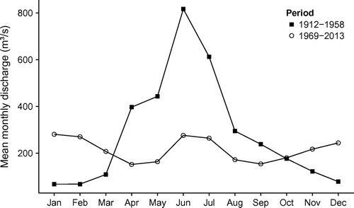
Construction of the dams began in 1959; Lake Diefenbaker was filled by 1967. The reservoir is managed by the Saskatchewan Water Security Agency (WSA) and serves a number of purposes including water supply for municipal, industrial and irrigation purposes; hydropower generation; flood protection; recreation; and commercial fishery. The reservoir shoreline has become a significant habitat for the endangered Piping Plover. Releases from the reservoir to the South Saskatchewan River enhance low flows to enable operation of municipal water intakes at Saskatoon, provide flood protection, allow additional downstream hydropower, enable ferry operations and provide in-stream aquatic habitat. Releases to the Qu’Appelle River are used to sustain low flows for downstream irrigation, municipal supply and recreational use purposes; these releases are very small compared to those to the South Saskatchewan River. As shown in Figure , the mean monthly discharges are much less variable in the post-dam period than they were in the pre-dam period.
Objectives
The objective of this study is to determine how the operation of Lake Diefenbaker affected flows downstream during the high-flow events in the years 2005, 2011 and 2013. The reasons influencing the decisions made are also examined. The analyses consist of three sections. First, the historical reservoir spring inflows and elevations are examined for trends to determine their influences on the management of Lake Diefenbaker. Second, the inflows to Lake Diefenbaker, and the management of the high flows, are examined for each of the years of interest. Finally, the downstream effects of the flows released from Gardiner Dam are examined, for the years of interest.
Data analyzed
Data sources
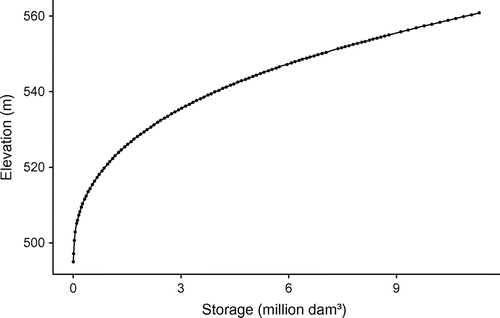
Daily reservoir elevations and streamflows were obtained from the Water Survey of Canada (WSC) collection of archived hydrometric data. The data may be queried online at http://www.wsc.ec.gc.ca/applications/H2O/ or can be downloaded as the HYDAT database from ftp://arccf10.tor.ec.gc.ca/wsc/software/HYDAT/. Continuity data for Lake Diefenbaker (discharges, reservoir elevations and the reservoir rating curve) were supplied by the WSA as described in Centre for Hydrology (Citation2012). Points on the elevation rating curve were extracted using the open-source digitization program Engauge, which is available at http://digitizer.sourceforge.net. The extracted points are plotted in Figure , together with the splines used for interpolation.
Figure 3. Volume rating curve for Lake Diefenbaker. The points were digitized from the rating curve described in Centre for Hydrology (Citation2012); the lines are splines used for interpolation.
The analyses presented in Centre for Hydrology (Citation2012) used preliminary (unofficial) values for the WSC data, as those were all that were available at the time. This study uses the official WSC values of flows and stages, which were queried from the online repository.
Daily precipitation values and hourly air temperatures, wind speeds and relative humidities for Outlook SK, which is the nearest weather station to Lake Diefenbaker (climate ID 4055736, WMO ID 71551), were downloaded from http://climate.weather.gc.ca/.
Inflows to Lake Diefenbaker
Stream inflows to Lake Diefenbaker may be divided into gauged and ungauged (local) inflows.
Gauged inflows
As there is no gauging station between the confluence of the Red Deer and South Saskatchewan rivers and Lake Diefenbaker, daily inflows from the South Saskatchewan River must be estimated from the closest Water Survey of Canada (WSC) gauging stations on these rivers. Over the period examined, these stations are the Red Deer River at Bindloss (WSC station 05CK004, data available from October 1960), and the South Saskatchewan River at Medicine Hat (WSC station 05AJ001, data available from June 1911). To allow for the travel time between the stations and Lake Diefenbaker, the inflows were estimated by simply shifting the upstream daily flows by a fixed number of days, as described by Centre for Hydrology (Citation2012). The daily inflows to Lake Diefenbaker from Swift Current Creek were estimated from the gauge at Swift Current Creek near Leinan (WSC station 05HD039, data available from March 1973). Over the period 1973–2013, during which all three gauges were active, the inflows from the South Saskatchewan River, Red Deer River and Swift Current Creek were 73.4, 25.9 and 0.6% of the total gauged inflows, respectively.
Local inflows
The local inflows to Lake Diefenbaker are usually very small, due to the region’s soils, climate and hydrography. As discussed by Gray and Landine (Citation1988), runoff in the Prairies is primarily due to snowmelt occurring on frozen soils, as rainfall events rarely produce intensities great enough to cause runoff from the deep, generally dry, Prairie soils. Convective storms can produce rainfall intensities large enough to cause runoff, but these storms are generally small and fast moving and are therefore unlikely to cause significant runoff over large basins.
The unusual hydrography in the region often prevents runoff from producing much streamflow. As discussed by Shook and Pomeroy (Citation2011) and Shook et al. (Citation2013), Prairie basins contain many thousands of small depressions (“sloughs”) which trap runoff before it can reach a stream channel.
Canadian drainage basins are designated as having a “gross drainage area,” which is the area within the divide, and an “effective drainage area,” which is defined as being the area which is estimated to contribute flow to the stream 1 year in 2 (Godwin and Martin Citation1975). Analysis of the South Saskatchewan River basin between Medicine Hat and Gardner Dam showed that only about 20% of the basin area (not including the reservoir area) is designated as being “effective,” indicating that most of the basin is not contributing flow to the lake much of the time.
When the depressions fill with water, they can connect, allowing water to flow to stream channels. Thus the contributing fractions of Prairie basins are dynamic and change according to the storage of water within the depressions. However, it is unusual for very large fractions of a basin of this type to contribute flow. Shook et al. (Citation2015) demonstrated that very highly skewed frequency distributions typical of Prairie streamflows are caused by runoff usually being abstracted by depressional storage, with rare episodes of connectivity.
In the years examined, the only example of important local inflows to Lake Diefenbaker appears to have occurred in April 2011. This spring saw large runoff due to the melt of a heavy snowpack, with reduced infiltration into soils that were wet from heavy rainfall in the previous summer and fall. The basin, and other regions in the Prairies, experienced unusually large contributing fractions, due to the surface depressions being very full of water from the wet summer and fall.
The local ungauged Prairie inflows for April 2011 were estimated by subtracting the sum of the routed inflows from total inflows.
The total inflows were estimated by applying continuity to Lake Diefenbaker, as:(1)
where:
I = daily total inputs = routed inflows (IR) + local inflows (IL) + direct precipitation (IP);
O = daily outputs = gauged outflow (OG) + lake evaporation (OE); and
ΔS = change in storage based on gauged elevations.
During the period 1–24 April, there was no precipitation recorded at the Outlook weather station (IP = 0). This allowed the local inflows to be estimated from:(2)
Errors in inflow data
The application of continuity allows assessment of the error in the routed gauged flows. The error in the daily water balance (E) was computed from:(3)
If errors in the change in storage are omitted, then positive values of E indicate that either the daily inflows are too small or the daily outflows are too large, or both.
Monthly open-water evaporation was estimated by the modified Meyer method (Berry and Stichling Citation1954), using the Outlook weather data. The monthly evaporation depths were evenly distributed to produce daily values.
The error in the daily water balance is plotted along with the estimated inflows and outflows in Figure . As the error term is a residual value, it incorporates all of the errors in all of its terms. The sources of the error include: error in the gauged flows, error in the (very simple) routing, error in the reservoir storage, error in the calculated evaporation, and error in the measured precipitation (and lack of areal distribution), the unknown local inflows and the omitted groundwater flow. Each of the daily major water balance input and output terms (direct precipitation, lake evaporation, routed inflow and gauged outflow) is shown as an absolute value percentage of the total error, aggregated to a monthly value, in Table . The purpose of this table is to demonstrate the possibility of each term being the source of the error in the water balance.
Figure 4. Lake Diefenbaker inflows, outflows and water balance errors in 2005, 2011 and 2013.
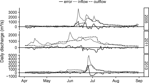
Table 2. Mean daily percentage (as an absolute value) of the water balance error by month for each of the major inflows and outflows.
Although evaporation and precipitation can be very important to the water balance of a reservoir on a seasonal or annual basis, they are generally small components of the daily water balance, particularly during periods of high inflows. Over the period studied, the computed evaporation and precipitation were each, on average, about 2% of the daily change in the reservoir elevation. The values listed in Table confirm that the direct precipitation and evaporation were too small to explain the error in the water balance.
As discussed by Centre for Hydrology (Citation2012), there was a very large wind setup event on Lake Diefenbaker on 17–18 June 2011, which caused large errors (positive and negative) in the computed inflows. The effects of this event were removed from the adjusted inflows.
If the error in the daily water balance were primarily due to the effects of waves and wind setup in Lake Diefenbaker, or to errors in the very simplistic routing, then it would be expected to be fairly consistent in magnitude, and to vary in sign from day to day, as these effects should cancel out over a few days. This can be seen in the plots in Figure for the months of April and August in all three years. During these periods, the magnitudes of precipitation and evaporation are their greatest relative to the inflows and outflows.
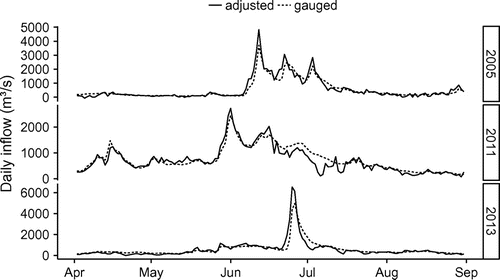
The relative magnitudes of the routed inflows and gauged outflows listed in Table are sufficient to explain the error in the water balance much of the time. The plots in Figure demonstrate that the greatest magnitude of the water balance error occurs when the stream inflows and reservoir outflows are greatest, and persists for several days at a time, indicating that the source of the error is primarily in the (time shifted) gauged flows and the reservoir storages computed from the gauged elevations. Regressions of the error against the inflows, outflows and elevations were inconclusive, although the strongest relationships were with the inflows in the years 2005, 2011 and 2013 (r² = 0.57, 0.18 and 0.49, respectively). If it is assumed that the error in gauged flows is related to their magnitude, then the inflows would be expected to be a greater source of error than the outflows, because the peak inflows are greater than the peak outflows. Based on this assumption, the gauged inflows were adjusted by adding the water balance error, to produce a corrected estimate of the actual inflow. Both sets of values are plotted in Figure . The actual inflows probably lie somewhere between the two lines.
Figure 5. Adjusted and gauged inflows to Lake Diefenbaker in 2005, 2011 and 2013.
Downstream flows
As discussed by Centre for Hydrology (Citation2012), there was some uncertainty in the magnitudes of the flows released from the Gardiner Dam in 2011. In this study, the official WSC gauged flows of the South Saskatchewan River at Saskatoon (WSC station 05HG001, available from 1911) are used as an index of the discharges from Gardiner Dam. Using these flows allows flows in all years to be compared.
No flow gauge currently exists between the confluence of the North and South Saskatchewan Rivers and the discharge from Tobin Lake. The coincidence of the peak flows was estimated by examining the timing of the flows from the WSC gauge of the North Saskatchewan River at Prince Albert (WSC station 05GG001, available from 1910) and that of the South Saskatchewan River at Saskatoon.
Analyses of trends in reservoir inflows and stages
All analyses were carried out using the free open-source software R (R Core Team Citation2013). Mann–Kendall tests for trends were carried out using the R package “Kendall” (McLeod Citation2011). Because of the influence of autocorrelation on the results of the Mann–Kendall test (Yue et al. Citation2002), all time series were tested for the presence of autocorrelation. A series whose autocorrelation function exceeded the 5% confidence limits for random data, for any lags greater than zero years, was deemed to be autocorrelated and therefore unsuited for the Mann–Kendall test. The minimum elevations were tested using the R package “zyp” (Bronaugh and Werner, Citation2013), which uses prewhitening to remove autocorrelation, based on the algorithm of Yue et al. (Citation2002), before performing the Mann–Kendall test.
The magnitudes of trends were assessed by computing their Theil–Sen slope. This method is a more robust estimation of slope than a simple least-squares model (Sen Citation1968) in that it is not affected by skewness in the underlying data set. However, as this slope is based on Kendall’s tau statistic, it can be affected by autocorrelation in the data. Where data were not autocorrelated, the Theil–Sen slope was computed using the R package “rkt” (Marchetto Citation2013). Where data were autocorrelated, their slope was computed from prewhitened values using the R package “zyp” (Bronaugh and Werner Citation2013).
Inflow trends
The Alberta inflows during April and May to Lake Diefenbaker appear to have declined over the interval 1969–2013, as shown in Figure . The data were not significantly autocorrelated. Mann–Kendall tests showed significant (5%) negative trends. The Theil–Sen slopes over the interval for April and May were –2.28 and –3.93 m³/s/year, respectively.
Figure 6. Gauged Alberta inflows to Lake Diefenbaker 1961–2013 for the months of April and May. The lines are least-squares linear regressions. The shaded regions represent the 95% confidence interval of the regressions.
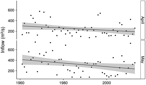
The trends are believed to be caused by filling of upstream storage reservoirs to supply irrigation demand in Alberta as the effects of climate change would tend to increase, not decrease, early spring inflows (Pomeroy et al. Citation2009).
Elevation trends
As shown in Figure , there is no significant trend (Mann–Kendall, 5%) in the annual maximum elevations over the period 1969–2013. The minimum reservoir elevations appear to have increased over the same period, but the time series is autocorrelated for lags of up to six years, preventing the use of a standard Mann–Kendall test. As described above, the autocorrelation was removed from the annual minimum elevations prior to determining the existence of a trend and its slope.
Figure 7. Annual maximum and minimum elevations of Lake Diefenbaker at Gardiner Dam, 1969–2013. The lines are least-squares linear regressions. The shaded regions represent the 95% confidence interval of the regressions.
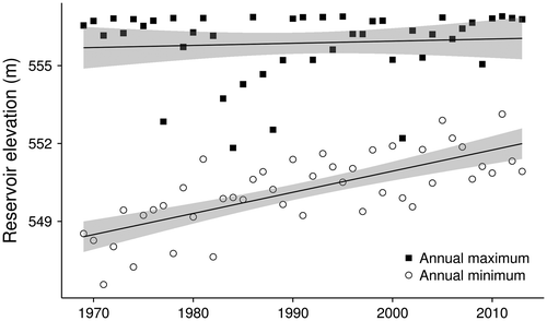
The minimum reservoir elevations were found to display a significant (Mann–Kendall, 5%) positive Theil–Sen slope of 0.083 m/year, corresponding to a total rise of over 3.6 m over the period. In some years the annual minimum elevation was greater than the annual maximum elevation in closely adjacent years. However, the minimum and maximum elevations of the reservoir in 2012 and 2013 were smaller than those in 2011.
Inflow events in 2005, 2011 and 2013
The adjusted inflows to Lake Diefenbaker are plotted in Figure for the selected years. As shown by the plots, and by the total inflows and the peak flows listed in Table , the events were very different from one another.
In 2005, three very large rain events resulted in three peak inflows to the reservoir, as described by Shook (Citation2015). This year had the second greatest peak inflow and the greatest total inflows of the three years.
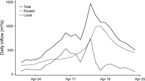
The April 2011 inflow event was caused by snowmelt runoff in the Alberta prairies and foothills, and by local inflows. The local inflows were largely due to the melt of a heavy snowpack, the reduced infiltration into already wet soils, and the large contributing fraction of the region caused by the surface depressions being very full of water.
The magnitudes of the routed, local and total inflows are shown in Figure . The peak inflows occurring in June were due to the melt of a near-record snowpack in the mountains, and rainfall events in the mountains and foothills. All of the events of 2011 are described by Centre for Hydrology (Citation2012).
Figure 8. Routed, local and total inflows to Lake Diefenbaker in April 2011.
The peak inflow in June 2013 was the result of a single large rainfall and rain-on-snow event in the mountains and foothills, as described by Pomeroy et al. (Citation2015, this issue). The peak inflow was greater than in 2005 and 2011, although the total volume of the annual peak was smaller than in those years.
Management of Lake Diefenbaker during the high-inflow events
To date, the management of Lake Diefenbaker has not been guided by formal operating procedures (Centre for Hydrology, Citation2012). As described previously, Lake Diefenbaker is operated for several competing purposes. The water year generally follows the following schedule:
| (1) | The reservoir generally reaches its greatest elevation around 1 September; | ||||
| (2) | Over the late fall to early winter the reservoir elevation declines slowly; | ||||
| (3) | Beginning in January, the reservoir elevation decreases rapidly as water is used for hydroelectric generation; | ||||
| (4) | The annual minimum generally occurs in March or April and is followed by the melt of the prairie snowpack; | ||||
| (5) | June rains in Alberta, along with rapid melt of the high mountain snowpack, cause the reservoir to rise. | ||||
The target elevations for Lake Diefenbaker, as shown in Table , are set to coincide with the major inflows. The operation of the reservoir requires the attainment of minimum reservoir levels in the spring, followed by higher target elevations in July. It is believed that the reservoir operators have compensated for the declining inflows by increasing the minimum reservoir elevation, thus reducing the ability to mitigate downstream flooding.
Table 3. Lake Diefenbaker target elevations.
Flood waves from Alberta take several days to travel to Lake Diefenbaker, giving the operators of the reservoir several days warning in advance of large events. This allows time to draw down the reservoir before the arrival of large inflows, increasing the storage available for flood mitigation.
2005 inflow management
Management of the 2005 inflows was complicated by the Alberta headwaters flood event being composed of three large peaks. As shown in Figure , the first event was almost completely attenuated by the reservoir operation. This event filled the majority of the available storage, as shown in Figure , leaving little storage remaining to manage the third peak flow; it was fortunate that this was the smallest of the three peaks.
Figure 9. Daily stage of Lake Diefenbaker at Gardiner Dam in 2005, 2011 and 2013. The horizontal lines are the full supply level (FSL). The points correspond to the target elevations listed in Table .
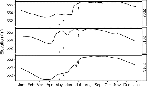
2011 inflow management
In 2011 the ability of the Lake Diefenbaker to manage the summer inflows was compromised by the reservoir being unusually high in the spring, due to maintenance and other considerations over the winter (Centre for Hydrology, Citation2012), as plotted in Figure . The available storage was further depleted by the very large spring inflows described previously. The reservoir was partially drawn down prior to the summer inflow peaks, but storage was exhausted quickly by storing the first summer inflow event, and the reservoir reached (and exceeded) its full supply level (FSL), reducing its ability to attenuate the subsequent peak inflows.
2013 inflow management
Of the three years considered, the inflows of 2013 were the simplest to manage, as they consisted of a single large event, as shown in Figure . However, these inflows also had the highest peak flows and were associated with massive flood damage in Alberta (Pomeroy et al. Citation2015, this issue). As described previously, the spring minimum elevation of Lake Diefenbaker in 2013 was much lower than that in 2005 or 2011, providing more storage for flood mitigation. The reservoir’s elevation was drawn down before the arrival of the high flows, as shown in Figure . However, the plot also shows that the reservoir did not approach its FSL until the middle of August, which was long after the passing of the peak inflows. Therefore, the operation of Gardiner Dam could have reduced the downstream peak flows more than it did. It is likely that over-prediction of peak streamflows at Medicine Hat in Alberta invoked a greater drawdown of the reservoir than was necessary.
Downstream effects
South Saskatchewan River flooding
Most of the City of Saskatoon is located well above the stages experienced during the high flow events of 2005, 2011 and 2013, although some low-lying areas were flooded in each of these years. Directly upstream of Saskatoon, some agricultural land is subject to flooding from the South Saskatchewan River. As noted by Förster et al. (Citation2008), the damage to agricultural land depends on the timing and the duration of flooding. Thus, estimation of the relative damage during each year requires estimation of both the areas and the durations of flooding.
The extent of agricultural flooding was estimated for each event, using a relationship between flooded area and the discharge of the South Saskatchewan River at Saskatoon described by Centre for Hydrology (Citation2012). The region susceptible to flooding lies within the floodplain of the South Saskatchewan, and is therefore subject to change due to sediment deposition and erosion, so estimation of flooded areas in other years is subject to error. Nevertheless, the method provides a way of objectively comparing flooding areas and durations among the three events.
The flooding area durations plotted in Figure were calculated using the inflows to Lake Diefenbaker (both the routed values and the adjusted values), and the flows of the South Saskatchewan River at Saskatoon. The differences between the inflow curves and that of the South Saskatchewan River, for each year, indicate how the management of the reservoir changed the extents of flooding.
Figure 10. Flooded area–duration curves for agricultural land upstream of Saskatoon in 2005, 2011 and 2013. The curves are calculated based on the inflows to Lake Diefenbaker (by routing, and adjusted) being passed directly through, and on the actual gauged flows of the South Saskatchewan River at Saskatoon.
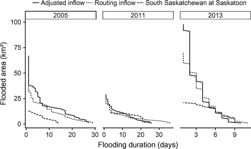
Based on the Saskatoon flows, the maximum flooded area in 2013 was the greatest of the three years. As defined by the integrated flooded duration and area, the 2011 event was not only the most severe of the three years of interest, but also the most severe since the construction of Lake Diefenbaker.
In all three years, the management of Lake Diefenbaker reduced the maximum flooded area and the integrated flooded duration and area. In 2005, the area of flooding was reduced for all flood durations. In 2011, the flooded area was reduced for very large and small flooded durations, but was increased for durations between 5 and 20 days, depending on which of the inflows (routed or adjusted) are used for comparison. In 2013, the flooded areas were increased for flood durations greater than 5 days.
Saskatchewan River flooding
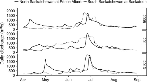
High streamflows on the Saskatchewan River may result from high flows on either or both of the North or South Saskatchewan rivers, but are most severe when peaks on both tributaries coincide. As shown in Figure , the operation of Lake Diefenbaker did not greatly affect the timing of the largest peak in either 2005 or 2013, although the magnitudes of the peaks were greatly diminished. In 2011, however, the discharge peak from Lake Diefenbaker was much broader than the inflow peak, and occurred much later.
The travel times from Saskatoon and Prince Albert to the confluence are unknown, so any estimation of the effects of the coincidence of the peaks must be approximate. However, it is evident from the plot in Figure that the peaks of the flows on the South and North Saskatchewan must have coincided in 2011, resulting in increased flows (and flooding) on the Saskatchewan River due to the reservoir operation.
Figure 11. Daily flows of the South Saskatchewan River at Saskatoon and the North Saskatchewan River at Prince Albert in 2005, 2011 and 2013.
Reservoir operation scenarios
Any number of scenarios of the operation of Lake Diefenbaker may be simulated. It is unfair to compare the results of operational scenarios with the actual operation of the reservoir, as the operators at the time had no knowledge of the future inflows and were operating under the restrictions of multiple objectives.
As described previously, the errors in the flows and storages prevent the closure of the water balance for Lake Diefenbaker. Therefore, the results for any simulation must be treated with great care.
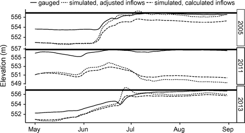
Fixed initial elevation scenario
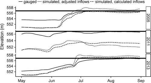
The effects of the increases in minimum reservoir elevations were examined by running simulations using the calculated inputs and outputs from 1 May elevations of 551 m, which is the minimum acceptable target elevation for that date, as listed in Table . The gauged elevations, and the values for scenarios using the calculated and adjusted inflows, are plotted in Figure for all three years. The simulations using the calculated inflows show that the reservoir would not have reached FSL in any of the years. Using the adjusted inflows, the reservoir elevation would have exceeded FSL in 2005 and 2013, but not 2011.
Figure 12. Simulation of Lake Diefenbaker using estimated inflows and outflows, and 1 May target elevations. The horizontal lines are the full supply level (FSL). The gauged lake elevations are also plotted.
Restricted discharge scenario
Had the initial elevation of Lake Diefenbaker been reduced, the discharges would not need to have been as large as their historical values, which might have ameliorated downstream flooding. Although an infinite number of operational scenarios can be run, for simplicity the outflows were restricted to the smaller of either the estimated outflows or the 1100 m³/s flowrate, at which flooding upstream of Saskatoon begins. The resulting reservoir elevations, and the gauged values, are plotted in Figure . The simulations using calculated inflows show that in 2005 and 2011, the reservoir would not have reached FSL, without downstream flooding, had the 1 May reservoir elevation been set at the target elevation. In 2013, the simulated reservoir elevations exceeded FSL, as also occurred for the 2005 simulations using the adjusted inflows. However, had the outflows been allowed to exceed the inflows, before inflows exceeded 1100 m³/s, the reservoir elevation could likely have been kept below FSL while preventing downstream flooding in 2005 and 2013.
Figure 13. Simulation of Lake Diefenbaker using estimated inflow and 1 May target elevations, with outflows restricted to being below downstream flooding flows. The horizontal lines are the full supply level (FSL). The gauged lake elevations are also plotted.
Conclusions
As the inflows to Lake Diefenbaker differed in 2005, 2011, and 2013, so did the management of the high flows. In particular, the management of the 2013 event appears to differ greatly from those of the 2005 and 2011 events.
To achieve the minimum target elevations listed in Table , in the face of declining spring inflows (described previously), the reservoir operators increased the minimum spring elevation of Lake Diefenbaker over the period of 1969 to 2011, as is plotted in Figure . Of course, the greater the minimum (spring) reservoir elevation, the smaller the magnitude of storage available to mitigate summer floods. The minimum elevations of Lake Diefenbaker in 2012 and 2013 were below those in 2011 (and 2005), suggesting that the operators of the reservoir had changed their procedures in the aftermath of the 2011 floods.
A consequence of the high minimum reservoir elevations in 2005 and 2011 is that the reservoir was unable to achieve the 1 July desirable range of maximum reservoir elevations listed in Table , when subjected to large summer inflows.
As shown in Figure , there was no attempt in 2005 and 2011 to restrict the elevation of the reservoir to the desirable range of target elevations listed in Table . However, it appears that in 2013 the operators did attempt to achieve the 1 July target elevations. The discharges from Lake Diefenbaker, which caused minor flooding near Saskatoon in 2011, could have been reduced or eliminated, had this been the objective in that year.
The scenario simulations indicate that the elimination of downstream flooding would have required continual adjustment of the discharges to optimize the storage in the reservoir, as is done by the flood operating procedures used by the Alberta Government reservoirs (Shook Citation2001). However, the optimal use of such procedures requires accurately modelling the inflow hydrograph, which is not currently done by the dam’s operators (Centre for Hydrology, Citation2012).
Most importantly, Lake Diefenbaker requires a set of operating procedures to define the rules of operation of the reservoir. One impediment to the establishment of such procedures is the necessity to forecast inflows to the reservoir over the spring and summer. These inflow forecasts are generally estimated probabilistically, based on the current state of the mountain snow pack, and on historical precipitation and streamflows (Garen Citation1992). However, current research has shown dramatic changes in mountain (Fleming and Dahlke Citation2014; Razavi et al. Citation2015) and prairie (Shook and Pomeroy Citation2012) hydrology and meteorology, indicating non-stationarity which invalidates the use of historical data for estimating future inflows. Physically based hydrological modelling, when combined with numerical weather and regional climate model predictions, may provide a method for estimating the seasonal reservoir inflows, allowing the spring reservoir minimum elevation to be determined probabilistically.
Acknowledgements
Financial support from Canada Research Chair, Natural Sciences and Engineering Research Council of Canada, the Saskatchewan Water Security Agency and the U of S Global Institute for Water Security is gratefully acknowledged. This research was done entirely with Free Open Source Software. All analyses were performed using R (R Core Team, Citation2013), and all graphs were plotted in R using the package “ggplot2” (Wickham Citation2009). The map in Figure was created with QGIS (www.qgis.org).
References
- Berry, W. M., and W. Stichling. 1954. Evaporation from lakes and reservoirs in the Northern Plains Region of North America. In IUGG General Assembly at Rome, IASH, 121–134. http://iahs.info/redbooks/a038/038017.pdf (accessed 2 January 2015).
- Bronaugh, D., and A. Werner. 2013. zyp: Zhang + Yue-Pilon trends package. R package version 0.10-1. The Pacific Climate Impacts Consortium. http://CRAN.R-project.org/package=zyp (accessed 9 January 2015).
- Centre for Hydrology. 2012. Review of Lake Diefenbaker operations. Centre for Hydrology final report to the Saskatchewan Watershed Authority. Saskatoon: University of Saskatchewan, 117 pp. http://www.usask.ca/hydrology/papers/Pomeroy_Shook_2012.pdf (accessed).
- Fang, X., and J. W. Pomeroy. 2007. Snowmelt runoff sensitivity analysis to drought on the Canadian Prairies. Hydrological Processes 19: 2594–2609. doi:10.1002/hyp.
- Fang, X., J. W. Pomeroy, C. J. Westbrook, X. Guo, A. G. Minke, and T. Brown. 2010. Prediction of snowmelt-derived streamflow in a wetland-dominated prairie basin. Hydrology and Earth System Sciences 14(6): 991–1006. doi:10.5194/hess-14-991-2010.
- Fleming, S. W., and H. E. Dahlke. 2014. Modulation of linear and nonlinear hydroclimatic dynamics by mountain glaciers in Canada and Norway: Results from information-theoretic polynomial selection. Canadian Water Resources Journal/Revue Canadienne Des Ressources Hydriques 39(3): 324–341. doi:10.1080/07011784.2014.942164.
- Förster, S., B. Kuhlmann, K.-E. Lindenschmidt, and A. Bronstert. 2008. Assessing flood risk for a rural detention area. Natural Hazards and Earth System Science 8: 311–322. doi:10.5194/nhess-8-311-2008.
- Garen, D. C. 1992. Improved techniques in regression-based streamflow volume forecasting. Journal of Water Resources Planning and Management 118(6): 654–670.
- Godwin, R. B., and F. R. J. Martin. 1975. Calculation of gross and effective drainage areas for the Prairie Provinces. In Canadian hydrology symposium 1975 proceedings, Winnipeg, Manitoba, pp. 11–14. 1975.
- Gray, D. M., and P. G. Landine. 1988. An energy-budget snowmelt model for the Canadian Prairies. Canadian Journal of Earth Science 25: 1292–1303.
- Marchetto, A. 2013. rkt: Mann–Kendall test, seasonal and regional Kendall tests. R package version 1.2. http://CRAN.R-project.org/package=rk (accessed 2 December 2015).
- McLeod, A. I. 2011. Kendall: Kendall rank correlation and Mann–Kendall trend test. R package version 2.2. http://CRAN.R-project.org/package=Kendall (accessed 3 July 2013).
- Pomeroy, J. W., D. de Boer, and L. W. Martz. 2007. Hydrology and water resources. In Saskatchewan: Geographic perspectives, eds. B. Thraves, M. Lewry, J. Dale and H. Schlichtmann, 63–80. Saskatoon, SK: Canadian Plains Research Centre.
- Pomeroy, J. W., X. Fang, and B. Williams. 2009. Centre for Hydrology report No. 6: Impacts of climate change on Saskatchewan’s water resources, 46. SK: Saskatoon. Saskatoon: University of Saskatchewan. www.usask.ca/hydrology/reports/CHRpt06_Impacts-Climate-Change-Sask-Water-Resources_Feb09.pdf
- Pomeroy, J. W., R. E. Stewart, and P. H. Whitfield. 2015. The 2013 flood event in the Bow and Oldman river basins: Causes, assessment, and damages. Canadian Water Resources Journal this issue.
- R Core Team. 2013. R: A language and environment for statistical computing. Vienna, Austria: R Foundation for Statistical Computing. http://www.r-project.org/ (accessed).
- Razavi, S., A. Elshorbagy, H. Wheater, and D. Sauchyn. 2015. Towards understanding non-stationarity in climate and hydrology through tree-ring proxy records. Water Resources Research 6(4): 1813–1830. doi:10.1002/2014WR015696.
- Saskatchewan Watershed Authority. 2012. Lake Diefenbaker Reservoir operations context and objectives. 50 pp.
- Sen, P. K. 1968. Estimates of the regression coefficient based on Kendall’s tau. Journal of the American Statistical Association 63(324): 1379–1389.
- Shaw, D. A. 2009. The influence of contributing area on the hydrology of the Prairie Pothole Region of North America. PhD thesis, University of Saskatchewan, 179 pp.
- Shook, K. 2001. Waterton Dam flood operating procedures. Edmonton, Alberta: Alberta Environment, Natural Resources Services, Water Management Division, Water Sciences Branch, Hydrology/Forecasting Section, 120 pp.
- Shook, K. 2015. The 2005 flood events in the Saskatchewan River Basin: Causes, assessment and damages. Canadian Water Resources Journal/Revue Canadienne Des Ressources Hydriques. doi:10.1080/07011784.2014.1001439.
- Shook, K. R., and J. W. Pomeroy. 2011. Memory effects of depressional storage in northern prairie hydrology. Hydrological Processes 25(25): 3890–3898. doi:10.1002/hyp.8381.
- Shook, K., and J. Pomeroy. 2012. Changes in the hydrological character of rainfall on the Canadian Prairies. Hydrological Processes 26(12): 1752–1766. doi:10.1002/hyp.9383.
- Shook, K., J. W. Pomeroy, C. Spence, and L. Boychuk. 2013. Storage dynamics simulations in prairie wetland hydrology models: Evaluation and parameterization. Hydrological Processes 27(13): 1875–1889. doi:10.1002/hyp.9867.
- Shook, K., J. Pomeroy, and G. van der Kamp. 2015. The transformation of frequency distributions of winter precipitation to spring streamflow probabilities in cold regions: Case studies from the Canadian Prairies. Journal of Hydrology 521(February): 395–409. doi:10.1016/j.jhydrol.2014.12.014.
- Wickham, H. 2009. ggplot2: Elegant graphics for data analysis. New York: Springer.
- Yue, S., P. Pilon, B. Phinney, and G. Cavadias. 2002. The influence of autocorrelation on the ability to detect trend in hydrological series. Hydrological Processes 16(9): 1807–1829. doi:10.1002/hyp.1095.