
Abstract
In the central part of the St. Lawrence Lowlands (Mauricie, Québec), Late Quaternary deglacial events led to the formation of a series of complex granular aquifers, such as those in the (1) Saint-Narcisse morainic complex, (2) paleodelta formed by the Saint-Maurice River, and (3) sandy littoral terraces left during marine regression. The aquifers are an important supply of potable water for most municipalities in the region, including the City of Trois-Rivières, which is a mid-size city where groundwater accounts for 46% of the water supply. The main objectives of this study were to build a three-dimensional (3D) model of the Quaternary deposits to define the main hydrogeological contexts of the Mauricie region and to characterize the regional aquifers. The compilation of existing hydrogeological data led to the selection of 5386 well logs that contained stratigraphic information of variable quality, ranging from only surficial sediment thickness to descriptions of fully cored boreholes. To supplement the existing data, fieldwork was undertaken in areas where few data were available, including 63 km of high-resolution seismic reflection surveys and 34 new boreholes. The final 3D model consists of six layers, from the bedrock surface to the upper littoral and deltaic sands. The total thickness of the deposits ranges from zero, on bedrock outcrops, to 150 m beneath central Trois-Rivières. Taking into account the thickness of the saturated layer and the porosity of the sand and gravel, the upper unconfined aquifer contains an estimated 364 million m3 of water. The 3D model helped refine the understanding of regional aquifers and was used to identify unexploited aquifers, notably around the Saint-Narcisse morainic complex and along the St. Cuthbert Fault. The model clarified the regional stratigraphic architecture, especially topography of the bedrock surface, the lateral extent of Late Quaternary sands and development of Holocene post-glacial sediment sequences.
Dans la partie centrale des Basses-Terres du Saint-Laurent (Mauricie, Québec), la dernière déglaciation a mené à la formation d’aquifères granulaires complexes, tels que ceux associés à la moraine de Saint-Narcisse, au paléodelta de la rivière Saint-Maurice et aux terrasses littorales associées à la régression marine. Ces aquifères représentent la source principale d’eau potable pour la majorité des municipalités de la région, incluant Trois-Rivières, une ville de taille moyenne où les eaux souterraines contribuent à 46% de l’approvisionnement. L’objectif de cette étude était de développer un model 3D des dépôts quaternaires afin de définir les principaux contextes hydrogéologiques et de caractériser les aquifères régionaux de la Mauricie. Le recensement des données hydrogéologiques existantes a permis de compiler les résultats de 5386 puits et forages contenant des informations stratigraphiques de qualité variable. Les données existantes ont été complétées par de nouveaux relevés, incluant 63 km de sismique réflexion haute résolution et 34 forages. Le model 3D final est constitué de sept couches, de la surface du rock aux sables littoraux et deltaïques superficiels. L’épaisseur total des sédiments quaternaires varie de nulle sur les affleurements rocheux à 150 m à l’ouest de la ville de Trois-Rivières. Le volume total des sables superficiels, dans les limites de la ville de Trois-Rivières, a été estimé à 4.7 milliards de m3. En tenant compte de l’épaisseur de la zone saturée et de la porosité moyenne du sable, la nappe libre contiendrait un volume de 364 millions de m3 d’eau. Le model tridimensionnel a permis d’approfondir la connaissance des aquifères régionaux et d’identifier des aquifères non exploités, notamment en marge de la moraine de Saint-Narcisse et le long de la faille de St-Cuthbert. Le model a également permis de préciser l’architecture des dépôts et la stratigraphie régionale, particulièrement en ce qui concerne la topographie de la surface du rock, l’extension latérale des dépôts pléistocènes et la séquence des sédiments postglaciaires.
Introduction
The current landscape of the St. Lawrence Valley is mainly the result of erosion and deposition during successive Late Quaternary events. Deglaciation was followed by a 2000-year-long incursion of an arm of the Atlantic Ocean into the St. Lawrence Lowlands, known as the Champlain Sea. During this marine episode, a series of coastal, deltaic and offshore depositional systems developed in the valley. Following the regression of the Champlain Sea and the drainage of its successor basin (Lake Lampsilis), fluvial incision, sedimentation and terrace formation by the early St. Lawrence River and its tributaries became the main centres for active geological processes in the valley. Elsewhere in the region, this late-glacial period was characterized by the development of peatlands, notably on the large flat surfaces of the St. Maurice paleodelta.
The last deglacial events led to the formation of a series of complex granular aquifers, such as the Saint-Narcisse morainic complex, the Saint-Maurice River paleodelta, and the stepped sandy terraces formed along the shores of the Champlain Sea and along the St. Lawrence River and tributaries. The characteristics and distribution of these aquifers are partially known through various hydrogeological studies conducted by municipalities, government agencies and private consulting firms. Unfortunately, these studies had limited application regionally because they were generally local in scope and scale. The first regional groundwater map of the Mauricie region was constructed by McCormack (Citation1983), who noted the good aquifer potential of the surficial and near-surface sediments of the north shore, while the aquifer potential of fractured bedrock was deemed lower. While he identified buried valleys filled with sand and gravel deposits, he did not evaluate the hydrogeological potential of these confined aquifers. In the nearby Lake Maskinongé area, Denis (Citation1974) also mentioned that the bedrock formations of the region had a low aquifer potential, while the granular aquifers were more important. Nonetheless, and despite these preliminary attempts to map the local aquifers, there is still a lack of comprehensive knowledge of the different hydrogeological units and their surface or subsurface distribution. Given the crucial importance of groundwater as a source of potable water in the region, from both quality of life and economic viewpoints, it was determined that a more thorough characterization and assessment of regional aquifers was needed.
Groundwater has been exploited in the Mauricie region since the nineteenth century to supply municipal water networks and for commercial purposes. In the town of Yamachiche, for example, an aqueduct was built in 1873 to extract spring water renowned for its high quality. In the early twentieth century, a brackish water source located in Saint-Léon-Le-Grand became known for its healing properties. Nowadays, the granular aquifers of the Mauricie region are the source of potable water for most of its municipalities, including the City of Trois-Rivières, which is one of the few small urban centers in Canada where groundwater constitutes a large part of the drinking water supply (46%). In addition, the use of geothermal energy for heating and cooling has expanded during the last decade. Given the relatively high groundwater temperature (10 °C in Trois-Rivières) and the high aquifer potential of the region, it is likely that geothermal systems will continue to expand rapidly in the near future to capture thermal energy from the warmer groundwater.
Given the lack of comprehensive knowledge about the regional aquifers and the crucial role of groundwater in the Mauricie region, a regional groundwater study was initiated by Université du Québec à Trois-Rivières (UQTR) researchers in collaboration with governmental agencies and regional partners (including the regional council of elected officials, regional municipalities, the City of Trois-Rivières and watershed agencies). The study was conducted between 2009 and 2013 as part of the Groundwater Knowledge Acquisition Program (PACES), sponsored by the Quebec Ministry of the Environment (MDDELCC). One of the main objectives of this study was to build a three-dimensional (3D) model of Quaternary deposits to better define the hydrogeological framework for the Mauricie region and characterize the aquifer properties.
Study area
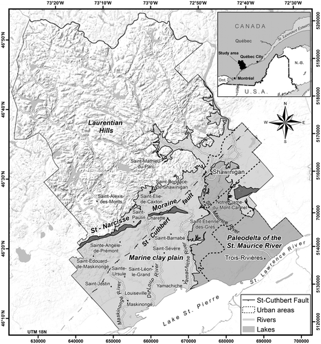
The study area (3900 km2) is located in the southwest of the Mauricie region, between Montréal and Québec (Figure ). The total population (2011) is 223,200 inhabitants, distributed into two main urban centers (Trois-Rivières and Shawinigan) and one regional municipality (Maskinongé). The northern part of the study area lies in the Laurentian Hills, and is mostly forested, whereas the southern part is underlain by the relatively flat terrain of the St. Lawrence platform and is occupied by farmlands, except for the urban area of Trois-Rivières. The Shield terrain of the Laurentians is characterized by steep-sided knolls and knobs, intersected by linear through-valley systems, often occupied by chains of lakes and logging roads, while the St. Lawrence platform is underlain by Paleozoic sedimentary rocks covered by thick Quaternary sediments, where agriculture is the main economic activity. The main rivers (Maskinongé, du Loup, Yamachiche and St. Maurice) flow southward from the Shield terrain to the lowlands. The hydrological regime of these catchments is characterized by spring snowmelt and low flow during summer with episodic storm events, typical of continental sub-humid, subpolar climates. Catchments receive between 850 and 1200 mm of precipitation annually, evenly distributed during the year.
Figure 1. Location and digital elevation model of the study area. The four main regional hydrogeologic contexts are shown: the Laurentian Hills, Saint-Narcisse morainic complex, Marine clay plain and paleodelta of the St. Maurice River.
First, a compilation map of bedrock formations was realized as part of this project, based on the studies conducted by Clark and Globensky (Citation1976), Globensky (Citation1987) and Nadeau and Brouillette (Citation1995). The lithological composition of the Grenville Province, a major subdivision of the Canadian Shield, consists mainly of igneous and metamorphic rocks, such as gneiss, orthogneiss, paragneiss, migmatite and marble, along with intrusive rocks such as gabbronorite, anorthosite, monzonite and monzogranite. The Grenville rocks are moderately folded in the allochthonous monocyclic belt and strongly folded in the polycyclic belt. The rocks of the Morin Terrane, in the south and west of the study area, were slightly deformed during the Grenville orogeny to form a large regional syncline.
The sedimentary rocks of the lowlands consist mainly of Ordovician sandstones, limestones and shales deposited in marine environments. Sandstones and limestones (Black River and Trenton groups) are exposed in isolated outcrops in the northern part of the lowlands, while the shales (Utica and Lorraine groups) are buried under considerable thicknesses of Quaternary sediments near the St. Lawrence River. These shales contain significant concentrations of natural gas as well as oil seeps and have been fully described in geological reports (Globensky Citation1987). The fractured bedrock aquifers, in both the Shield and the lowlands, only supply private wells.
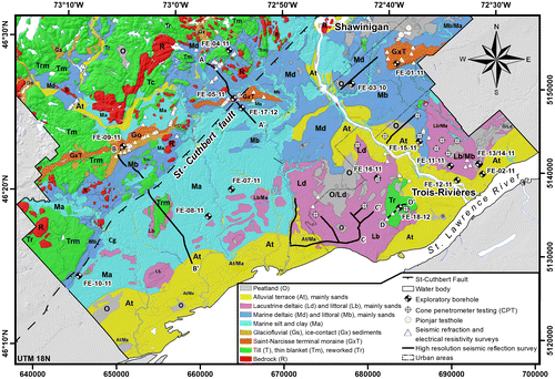
Secondly, an updated map of surficial deposits was constructed (Figure ) based on results of previous studies by Denis (Citation1974), Bolduc (Citation1999a, Citation1999b) and Lamarche (Citation2005). The Laurentian Hills are characterized by a thin till veneer with numerous rock exposures. Along the southern edge of this hilly region, valleys are floored by silty or silty-sandy marine sediments that commonly overlie ice-proximal sandy gravels that are buried. The Saint-Narcisse Moraine lies along the southern margin of the Canadian Shield, but slightly beyond in the St. Maurice River valley. The moraine was emplaced by a re-advance of the Laurentide Ice Sheet during the early cold phase of the Younger Dryas. In stratigraphic sections in the moraine, a variety of sediment facies, including glacially entrained clay and till wedges, are exposed along with proximal glaciomarine deposits, melt-out till and ice-marginal outwash (Occhietti Citation2007). As the Laurentide Ice Sheet retreated to the north, the Champlain Sea flooded the Saint Lawrence Valley up to almost 200 m asl, an event that led to the deposition of a thick silt and clay cover in the deeper offshore basins and littoral and sublittoral sands in shallower areas. Deltas, large and small, also formed in valleys at the mouth of rivers entering the Champlain Sea.
Figure 2. Quaternary geology and location of the new geophysical surveys and boreholes. The locations of the existing boreholes and wells (5386) used to build the model are not shown. See Table for a detailed description of the units.
The Quaternary stratigraphy of the area was described by Gadd and Karrow (Citation1959), Denis (Citation1974), Occhietti (Citation1980, Citation2007), Ferland and Occhietti (Citation1990) and Clet and Occhietti (Citation1996). The most complete stratigraphic sections were observed along the St. Maurice River. The base of the Quaternary sequence is characterized by a fluvial sediment complex directly overlying bedrock. This unit is correlated with the Lotbinière Sand (Hardy and Lamothe Citation1997), rather than the St. Pierre Sediments as originally thought by Gadd and Karrow (Citation1959). The overlying unit, containing a 9-m-thick varve series, is known as the St. Maurice Rhythmites since it corresponds to a lacustrine environment younger than that of the Deschaillons Varves (Besré and Occhietti Citation1990). The rhythmites are overlain in the regional stratigraphic record by the stratified Vieilles-Forges Sands, with three lithozones (lacustrine, deltaic and proglacial). This sequence is capped by the Gentilly Till, which is in turn overlain by the usual postglacial sequence containing glaciofluvial sediments, Champlain Sea sediments, Lake Lampsilis sediments, and alluvial and organic sediments.
Methods
Compilation of existing borehole data
Existing hydrogeological data were compiled from the sources presented in Table . All the municipalities in the study area were visited to obtain existing hydrogeological studies. The databases from the major water supply providers were integrated, including those from the cities of Trois-Rivières and Shawinigan and from a regional water supply network (Régie d’Aqueduc de Grand-Pré). The compilation of existing hydrogeological data led to the selection of 5386 logs for the modelling that contained some stratigraphic information. Among these entries, 2185 reached bedrock and 3201 ended within Quaternary sediments. The reliability of the existing data was evaluated based on the criteria proposed by Ross et al. (Citation2005) and Chesnaux et al. (Citation2011), and hydrostratigraphic codes were assigned to each entry in the database. When available, the hydraulic properties were integrated to the database.
Table 1. Sources of hydrogeological data.
Table 2. Quaternary stratigraphy of the study area.
Field work
To supplement the existing data, fieldwork was undertaken in areas where data were sparse or the stratigraphic interpretations were uncertain (Figure ). The new fieldwork included:
| • | 75 electrical resistivity surveys (using a TX-II transmitter and PP GRX-832 receiver). The interpretations were validated with borehole logs located within 500 m of the survey line; | ||||
| • | 50 seismic refraction surveys (using a Smartseis ST with 24 geophones); | ||||
| • | 63 km of high-resolution seismic reflection surveys (using the Minivibe); | ||||
| • | 11 cone penetration tests (using a Geotech 605D); | ||||
| • | 23 boreholes were drilled by different techniques (rotation, percussion, pionjar and rotasonic). Monitoring wells were installed in most of the boreholes. The sediments were sampled at regular intervals or at the transition between two stratigraphic units. Particle size analysis (Analysette 22 MicroTec) was carried out on 425 samples. The hydraulic conductivity of each sample was estimated from the grain size analysis. Radiometric dating (Beta Analytic Inc.) was conducted on three samples of shells or organic material. Water-level measurements and pumping tests were carried out in most wells. | ||||
Finally, detailed Quaternary geology mapping was carried out throughout the region, but more specifically in areas along the boundaries of maps created by different authors. The data collected in the field allowed us to produce a relatively uniform compilation map of surficial sediments for the study area.
Geostatistical modelling approach
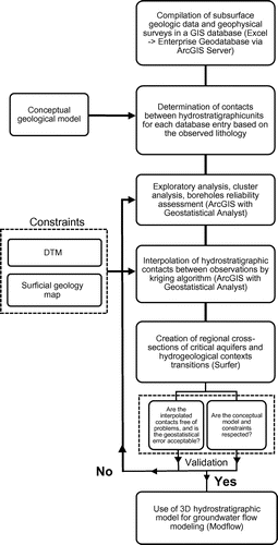
Cokriging was used to create gridded surfaces connecting the logs according to the elevation of stratigraphic contacts. This method of geostatistical estimation considers the spatial covariance and assigns a different weight to the observations based on their reliability. A digital elevation model (DEM) was used to determine the elevation of all borehole sites included in the database. The model also considered the outcrops of all deposits and the known stratigraphy shown on geological sections. Additionally, some adjustment points were manually added to the model at locations where available data were either insufficient or inadequate. For example, the range of the variogram was sometimes insufficient to properly interpolate grid values up to the boundaries of the study area and some adjustment points were added to fill in the void. The adjustment points were not included in the calculation of the error for each layer. Virtual sections were also generated using Hydro GeoAnalyst software to link, at the regional scale, similar facies where data are sparse or widely spaced (Ross et al. Citation2005). A final validation was performed to check whether the model-generated layers were contained in the volume between the rock surface and the ground surface. Figure shows the flowchart of the geographical information system (GIS) operations used to model the top surface of each hydrogeological unit.
Figure 3. Flowchart of the geographic information system (GIS) operations used to model the top surface of each hydrogeological unit.
Results
Three-dimensional mapping of Quaternary deposits
The model consists of seven layers representing the topography of the bedrock surface and the main hydrogeological units encountered in the study area. Because the model is being constructed at a regional scale, some units (Table ) were merged with others in order to give precedence to the more extensive and thicker aquifers and aquitards.
Topography of the bedrock
A total of 1584 observations from boreholes and geophysical data were used to model the surface of the bedrock. Before the addition of adjustment points, the root mean squared error between the observed and predicted values was 5.0 m. In addition, 484 bedrock outcrop areas were used as control to model the bedrock surface.
In the lowlands, near the St. Lawrence River, the smooth bedrock surface lies as much as 100 m below present sea level. However, the bedrock surface rises to the northeast of the St. Maurice River and on the south shore of the St. Lawrence River. On a south–north axis, the bedrock surface rises slowly northwestward toward the Piedmont, except along the St. Cuthbert Fault, which is the locus of a northeast-trending linear depression in bedrock. The maximum elevation of 540 m asl is reached in the Laurentian Hills, north of the municipality of Saint-Alexis-des-Monts.
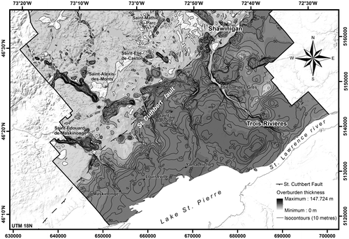
Figure shows the total thickness of Quaternary deposits. This map was produced by subtracting the elevation of the DEM surface from the elevation of the bedrock surface. The thickest deposits reach 150 m in the western part of the City of Trois-Rivières where the bedrock surface lies at −80 m, an elevation which is quite similar to that underneath Yamachiche and which is amongst the lowest of the entire central St. Lawrence Lowlands (Prévôt Citation1972).
Figure 4. Total thickness of Quaternary deposits. The thickest deposits, reaching 150 m, are in the western part of the City of Trois-Rivières.
Pre-LGM Quaternary sediments
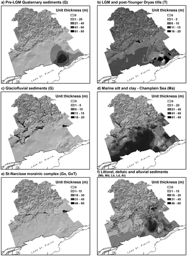
Pleistocene sediments deposited prior to the Last Glacial Maximum (LGM) have been observed in sections bordering the St. Maurice River and were also intersected by drilling in the southeast part of the study area. A total of 85 observations from boreholes and geophysical data were used to model the upper contact of pre-LGM sediments (Figures a and a). Before the addition of adjustment points, the root mean squared error between the observed and predicted values was 8.6 m. In addition, three surficial outcrops were used to control the modeled surface. Reliable drilling logs containing descriptions of the unit were only found around the City of Trois-Rivières, where the maximum thickness of the unit is 80 m. However, it is possible that other remnants of pre-LGM Quaternary sediments are preserved elsewhere in the region. Given their rare occurrence in the drilling record, no attempt was made to model separately the different pre-LGM sediment subunits in the 3D hydrostratigraphical model. However, some pre-LGM subunits could be identified in high-resolution seismic profiles. These deposits are discontinuous and their thickness varies depending on the topography of the bedrock surface.
Figure 5. Three-dimensional model of Quaternary deposits. The model consists of six layers representing the main hydrogeological units observed above bedrock in the study area. The six layers represent the Pleistocene sediments (pre-Last Glacial Maximum, LGM) (a), LGM and post-Younger Dryas tills (b), glaciofluvial sediments (c), marine silt and clay (d), Saint-Narcisse morainic complex (e) and littoral, deltaic and alluvial sediments (f).
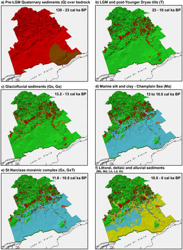
Figure 6. Thickness grids (m) of Quaternary deposits. LGM, Last Glacial Maximum.
LGM and post-Younger Dryas tills
Gentilly Till is the regional surficial diamicton (till) deposited during the Wisconsinan glaciation. In the context of this paper, it includes diamictons that were deposited during and after the Saint-Narcisse Moraine episode. Gentilly Till is a sandy-silt diamicton having a Precambrian crystalline rock content ranging from 100% in the Shield terrains to less than 10% on the Paleozoic platform. A total of 162 observations from boreholes and geophysical data were used to model the upper contact of Gentilly Till (Figures b and b). Before the addition of adjustment points, the root mean squared error between the observed and predicted values was 3.6 m. In addition, 241 surficial polygons were used to model the surface of the unit.
In the Laurentians, the glacial till cover is discontinuous and its thickness varies from 0.1 to 2 m. However, the till can be 6 m thick where mapped as continuous cover. Along the Saint-Narcisse Moraine, the till thickness varies between 1 and 50 m. In drilling records around the moraine, till wedges (thrust slices in most cases) deposited by the advancing ice sheet are difficult to differentiate from glaciofluvial sediment bodies emplaced subsequently and commonly reworked by littoral Champlain Sea processes. South of the moraine, in the clay plain, the till usually takes the form of a veneer varying in thickness depending on the topography of the bedrock surface.
Glaciofluvial sediments
Sediments carried by glacial meltwater were deposited in the deep valleys of the Canadian Shield and in bedrock depressions along the St. Cuthbert Fault. In the northern part of the study area, at elevations above 200 m asl, these sediments are well exposed at the surface, while in very deep valleys and on the Shield margins, they are almost continuously covered with fine-grained sediments of marine or lacustrine origin. A total of 341 observations from boreholes and geophysical data were used to model the upper contact of glaciofluvial sediments (Figures c and c). Before the addition of adjustment points, the root mean squared error between the observed and predicted values was 2.6 m. In addition, 117 sediment surface polygons were used to control the modeled surface. The largest thicknesses were observed under the deep valleys of the Canadian Shield, under the Saint-Narcisse Moraine and along the St. Cuthbert Fault.
Marine silt and clay
As the St. Lawrence valley had been isostatically depressed by the Laurentide Ice Sheet, an arm of the Atlantic Ocean, known as the Champlain Sea, inundated the valleys up to elevations equivalent to 200 m asl (Parent and Occhietti Citation1988, 1999). The marine transgression lasted about 2000 years (between 13 to 1.2 cal ka BP), and the incursion was characterized by the deposition of thick, sparsely fossiliferous marine clays. Around 9.8 ka BP (11.2 cal ka BP), marine waters gradually drained due to the isostatic rebound and salt water was replaced by fresh water (Lake Lampsilis). With continued isostatic adjustment, as well as reduced meltwater influx to the basin, Lake Lampsilis was gradually drained by the Proto-St. Lawrence River (7.5 to 3.0 cal ka BP).
A total of 2287 observations from boreholes and geophysical data were used to model the upper contact of marine and lacustrine sediments (Figures d and d). Before the addition of adjustment points, the root mean squared error between the observed and predicted values was 5.1 m. In addition, 118 sediment surficial outcrops were used to control the modeled surface. Marine and lacustrine sediments overlie till and glaciofluvial sediments in the major valleys of the Canadian Shield, as well as most of the St. Lawrence Lowlands. The thickest units of fine-grained sediments are located around the municipalities of Yamachiche and Louiseville, where more than 80 m of silt and clay are recorded in the drilling records. These maximum thicknesses are controlled by a depression in the bedrock around Lake St. Pierre (Prévôt Citation1972). In the paleodelta of the St. Maurice River, the thickness of subsurface silty clay sediments varies from 0 to 30 m.
Saint-Narcisse morainic complex
The Saint-Narcisse morainic complex was emplaced during a re-advance of the Laurentide Ice Sheet from 12.9 to 12.5 cal ka BP, along the southern margin of the Laurentians where it forms a 750-km-long crest (Occhietti Citation2007). From west to east, the moraine successively covers the Precambrian bedrock and then fine-grained Champlain Sea sediments in the St. Maurice valley. The moraine forms prominent ridges near Charette and Mont-Carmel. The moraine is composed of reworked clay and till, proximal glaciomarine deposits and melt-out till and ice-marginal outwash (Occhietti Citation2007).
A total of 75 observations from boreholes and geophysical data were used to model the upper contact of the Saint-Narcisse morainic sediments (Figures e and e). Before the addition of adjustment points, the root mean squared error between the observed and predicted values was 7.5 m. In addition, 41 sediment outcrop polygons were used to control the modeled surface. In the Lower Mauricie region, the composition of the morainic complex varies widely, but generally it consists of gravel, coarse sand and poorly sorted medium sands deposited above a layer of marine sediments. The thickness of this layer of coarse sediments varies from 10 to 50 m.
Littoral, deltaic and alluvial sediments
During the Holocene, the retreat of the ice sheet was accompanied by regional isostatic uplift estimated at 9 m/100 years (Lamarche Citation2005). The Champlain Sea was replaced by Lake Lampsilis, a freshwater successor basin that lasted about 1500 years. The present drainage system was gradually emplaced, thus creating successive terrace levels as base levels fell. The modelled layer that represents the surface sands includes (1) all sand units overlying fine-grained Champlain Sea sediments, including coastal and deltaic silty sands, (2) lacustrine sands and silts of Lake Lampsilis, and (3) marine and lacustrine deltaic sands of the St. Maurice River (Figures f and f).
The upper sands are exposed at the land surface and therefore were not modelled separately. The unit covers a total area of 1078 km2. The thickest areas of the surface sand aquifer are located in the western and eastern sectors of the City of Trois-Rivières, as well as in the localities of Sainte-Angèle-de-Prémont, Saint-Élie-de-Caxton and Charette. In the Trois-Rivières area, the total volume of the upper aquifer is estimated at 4.7 billion m3, 31% of which is saturated according to the subsurface records. The unit has an estimated porosity of 25%; this means that about 364 million m3 of water are contained in the unconfined aquifer. The aquifer has an average hydraulic conductivity of 6 × 10⁻⁴ m/s. Groundwater generally flows toward the southeast, its level ranging from 60 m upstream to 6 m at the outlet. Champlain Sea clays form the floor of the upper aquifer, preventing groundwater from seeping farther down through the Quaternary sequence. This aquifer is the most extensively exploited in the region and supplies drinking water to about half of the population of the City of Trois-Rivières.
Regional hydrogeologic contexts
Based on the 3D model, the four main regional hydrogeologic contexts of the study area were determined from the physiographic, geological and hydrogeological features (Figure ). The hydraulic properties of the aquifers pertaining to each context are presented in Tables and .
Table 3. Hydraulic properties of the regional granular aquifers: hydraulic conductivity (K), transmissivity (T), saturated thickness (b), coefficient of storage (S) and specific capacity (Q/s). See location map in Figure 1.
Table 4. Hydraulic properties of the regional fractured rock aquifers: hydraulic conductivity (K), transmissivity (T), saturated thickness (b), coefficient of storage (S) and specific capacity (Q/s). See location map in Figure 1.
Laurentian Hills
This hydrogeological context consists of fractured bedrock aquifers with low productivity (Table ) along with granular aquifers within glaciofluvial deposits filling deep valleys. Up to an elevation of 200 m asl, these deposits were covered by marine silts during the Champlain Sea marine transgression. Electrical resistivity surveys revealed over 60 m of silty clay in the Rivière-du-Loup Valley. Similar contexts were also encountered in the valleys of the Maskinongé, Yamachiche and Shawinigan rivers.
Elsewhere in the Laurentian Hills, deltaic sands and gravels were deposited by meltwaters at the mouths of major valleys entering the Champlain Sea. The glaciofluvial and deltaic deposits were reworked by waves and currents, forming the high and low terraces along the piedmont. The aquifers found in these deposits are the main source of potable water for most municipalities in the area.
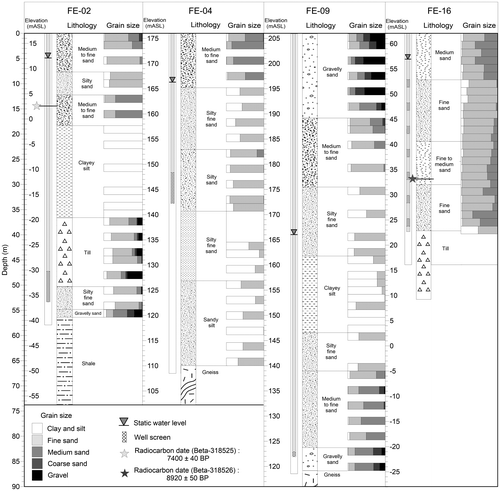
The geologic log for borehole FE-04-11 (Figure ), located in the village of Saint-Élie-de-Caxton, illustrates this typical hydrostratigraphic complex. Directly overlying granitic gneiss bedrock, at depth of 65.5 m, Champlain Sea sediments from 109 to 140 m asl consist of ice-proximal sandy facies grading upward into a distal clay facies at 134 m asl. The top layer consists of fine prodeltaic sands.
Figure 7. Logs of selected boreholes with lithology and grain size. The locations of the boreholes are shown in Figure 2.
Saint-Narcisse morainic complex and Laurentian foothills
The morainic complex frequently forms double aquifers with an unconfined aquifer within the surface sands, and a confined aquifer in the glaciofluvial sediments underlying a clay or till aquitard resting on bedrock. These aquifers are relatively small and hydraulically isolated from each other. Several electric resistivity surveys indicated an overall thickness of over 60 m. Borehole FE-09-11 is representative of this hydrostratigraphic setting (Figure ). The bedrock (garnet gneiss) was reached at a depth of 87 m. Overlying bedrock is a glaciofluvial unit consisting of sands (fine, medium and coarse) and gravel, which is overlain by the Champlain Sea clays and silts from a depth of 44 to 67 m. The overlying units include a coarsening-upward sequence of silty fine sand to gravelly sand with a high hydraulic conductivity associated with the Saint-Narcisse readvance.
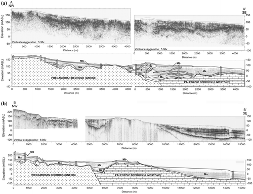
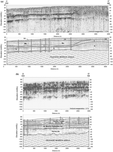
The L1-2011 Minivibe line was run perpendicularly across the morainic complex (Figure a). The line begins over Precambrian bedrock in the north, which is buried by marine clays and thin beach sands. It passes over a narrow bedrock valley before crossing the moraine (GxT) and entering the marine clay plain. The moraine is locally covered by a thin layer of sand, and overlies heterogeneous glaciofluvial deposits. The glaciofluvial sands and gravels rest on glaciotectonized clay and till wedges emplaced by the advancing glacier.
Figure 8. High-resolution seismic survey lines L1-2011 (a) and L7-9-2010 (b) The profile interpretations are shown below the seismic profiles. See Figure 2 for location of the seismic lines and Table for a detailed description of the units.
Although the hydrostratigraphy of the moraine is complex, it contains an important regional aquifer, as most of the small municipalities located along the moraine and in the adjacent marine clay plain draw their drinking water from it. Moreover, the moraine acts as a recharge area for the sandy surface aquifers connected to it. New boreholes and geophysical surveys completed for this project revealed the presence of double aquifers along the moraine that have not yet been exploited for a municipal water supply.
Marine clay plain
The fine-grained sediments of the Champlain Sea sequences represent a regional aquitard that confines the underlying aquifer unit containing groundwater with high mineral content and natural gas. The aquifer potential of the clay plain is generally low. The municipalities of this area rely on a regional water supply network (Régie d’Aqueduc de Grand Pré) whose wells are located near the foothills of the Laurentian Hills. However, there are also a few private wells drawing water from the sandstone and limestone bedrock.
The L7-9-2010 Minivibe lines (Figure b) are representative of the clay plain. In the south part, surficial sediments consist mainly of silt and clay ranging in thickness from 60 to 70 m, gradually decreasing farther north. The underlying till becomes a thin veneer over a partly buried rock ridge between kilometres 6 and 8.5. The bedrock surface then plunges abruptly to form a depression 2 km wide and 80 m deep. The buried depression appears to be filled with about 20 m of gravel and sand. The depression is covered by fine-grained marine sediments. This unit could potentially hold significant quantities of groundwater. The axis of these deposits lies directly over the St. Cuthbert Fault, which is a regional structure marking the boundary between Precambrian Shield and sedimentary rocks of the Lowlands. It is possible that similar sand and gravel aquifers are present elsewhere along the fault.
Paleodelta of the St. Maurice River
The paleodelta of the St. Maurice River is the largest aquifer in the region. The delta forms a wide sand-dominated fan over a thin layer of silty marine sediments on the east side of the river, and over a thick layer of pre-LGM deposits on the west side. Over the northern part of the delta, the unconfined surficial aquifer is thin and is less productive and not exploited, except for erosion channels where the sediment is thicker and the sands better sorted. The surficial aquifer has a much greater thickness in the southern part of the delta. Borehole FE-16-12 (Figure ) contains almost 40 m of sand of varying grain sizes. A wood sample found at 29.8 m depth in the upper delta surface was dated at 8920 ± 50 BP (10.05 cal ka BP; Beta-318526). This date provides an age for the beginning of the construction of the St-Maurice delta in the Lake Lampsilis.
The aquifer is one source of drinking water for the greater Trois-Rivières area. A confined aquifer is also present below the marine clays, in pre-LGM sands (Vieilles-Forges). However, data characterizing the aquifer are scarce. It is seldom used as a water source because the quality of the groundwater is poor.
The L3-2010 and L3-2011 seismic lines were run parallel to the axis of the St. Lawrence River (Figure ). These profiles illustrate the transition from the deep-water depositional environment of the clay plain and the complex geology of the delta, including the Lake Lampsilis sands, pre-LGM sediments and Gentilly Till. To the west of the delta, the bedrock topography shows little variation, with a mean elevation of about −50 m below sea level. The fine-grained sediments of the Champlain Sea fill the basin to a thickness of 80 m. The recent alluvial deposits of Lake Saint-Pierre cover the sequence with 10 m of fine sands and silts. The light reflector observed in the marine sequence could correspond to the Yamachiche Diamicton (Occhietti Citation1980), which is a thin, discontinuous coarse-grained deposit associated with the Saint-Narcisse Episode. The sequence below the clay unit includes the Gentilly Till, Vieilles-Forges Sand, St. Maurice Rythmites, Deschaillons Varves, and Lotbinière Sand. Only the first three units could be differentiated from the drilling logs.
Figure 9. High-resolution seismic survey lines L3-2010 (a) and L3-2011 (b). The profile interpretations are shown below the seismic profiles. See Figure 2 for location of the seismic lines and Table for a detailed description of the units.
On the L3-2010 Minivibe line (Figure a), the till thickness varies from 4 m at the beginning of the section, to over 20 m at kilometer 1.4, where the Lotbinière Sand begins to thin out. Champlain Sea silt and clay completely wedge out at kilometre 2.8, where the sand of the Champlain Sea-Lake Lampsilis succession rest directly on the till which rises to shallow depths above the pre-LGM sediments. At this location, drilling indicates that pre-LGM sediments constitute the largest part of the Quaternary column (over 80 m).
The L3-2011 Minivibe line (Figure b) is the continuity of the preceding sequence, about 1 km further south. The Champlain-Lampsilis sands are no longer present and till is observed at the surface all along the 3-km-long profile. The available drilling logs allowed the differentiation of the Vieilles Forges Sand and the Saint-Maurice Rythmites from the deeper and older Pleistocene sediments.
To the east of the delta, a series of deltaic, lacustrine and alluvial sands form a vast aquifer with a thickness ranging from 11 to 35 m. The aquifer overlies an impermeable clay (aquitard unit) with an average slope of the top surface coincident with the topography of the land surface (toward the southeast). The aquifer is complex with significant vertical heterogeneity, containing interstratified medium to silty sand layers. The Quaternary deposits encountered in borehole FE-02-11 (Figure ) are 56.4 m thick and rest on the Ordovician sedimentary platform. Gentilly Till, identified at 38 m depth (−22 m below sea level), overlies a sequence of undifferentiated Pleistocene sediments that is 8 m thick. Champlain Sea clay overlies the till between 18 and 37 m depth. The uppermost unit, from 0 to 18.3 m, consists of alluvial, littoral and deltaic sediments that were reworked by the fluctuating water levels of the St. Lawrence River. The base of this unit has been dated at 7.4 ka BP (8.2 cal ka BP; Beta-318525) on the basis of a wood fragment recovered at a depth of 14.5 m. Since the alluvial unit from which the wood fragment was recovered marks the return to present-day conditions in the St. Lawrence River, Beta-31526 provides a maximum age for the end of delta construction. Taken together, the two 14C dates indicate that the main part of the St-Maurice delta was constructed in about 1800 years, between 10.05 and 8.2 cal ka BP.
Hydrostratigraphic units
The 3D hydrostratigraphical model allowed the identification of four main hydrostratigraphic units with a regional distribution:
| • | Unit 1: An aquifer within fractured bedrock, divided into three sub-units: (1) aquifer in crystalline rocks (with low fracture density) of the Precambrian basement; (2) aquifer in brittle sedimentary rocks (sandstones and limestones); and (3) aquifer in ductile sedimentary rocks (shales). This unit, while it has a regional extension, has a low potential for a water supply and is not being tapped by municipalities. | ||||
| • | Unit 2: An aquifer in glaciofluvial and glacial sediments. This unit generally lies immediately above bedrock. The aquifers in glaciofluvial sediments, despite their small size and discontinuous areal distribution, supply a number of municipal wells. Till deposits, for their part, are thin and have a low permeability. However, water yields are generally sufficient to supply domestic wells. | ||||
| • | Unit 3: The regional discontinuous aquitard formed by fine-grained Champlain Sea sediments. The deposits overlie almost continuously older Quaternary units in the St. Lawrence Lowlands as well as in some isolated valleys or depressions of the Laurentian Hills. | ||||
| • | Unit 4: An aquifer formed in the uppermost sandy sediments. The unit can be divided into two sub-units: (1) sand and gravel deposits within the Saint-Narcisse morainic complex; and (2) surficial sand deposits overlying fine-grained sediments of the Champlain Sea, including coastal and deltaic silty sands, sands and silts of Lake Lampsilis and marine and lacustrine deltaic sands emplaced by the Saint-Maurice River. | ||||
Integrating the 3D model, architecture of the hydrostratigraphic units and regional distribution of hydrogeological conditions leads us to define five aquifer types, shown in Figure :
| • | Type 1: Unconfined fractured bedrock aquifers, which may be locally overlain by a thin layer of till; | ||||
| • | Type 2: Confined (a) or semi-confined (b) fractured bedrock aquifers overlain by marine silt and clay (aquitard); | ||||
| • | Type 3: Unconfined aquifers in glaciofluvial sediments or littoral sands that lie directly on the bedrock; | ||||
| • | Type 4: Double aquifers consisting of an upper, unconfined sandy aquifer and a confined (a) or semi-confined (b) aquifer in the fractured bedrock. These aquifers are separated by the regional aquitard; | ||||
| • | Type 5: Additional confined aquifers in glaciofluvial sediments that lie directly on the bedrock and are overlain by marine silt and clay (aquitard). These units may lie underneath other units to form aquifer complexes. | ||||
Figure 10. Aquifer types of the Mauricie region based on the architecture of the hydrostratigraphic units.
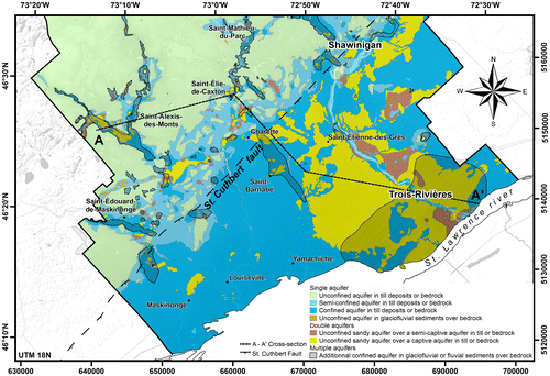
Figure shows the distribution of the above aquifer types. Type 1 is the most common aquifer in the Laurentian Hills, except in the valleys where types 2–5 are found, such as the Saint-Alexis-des-Monts aquifer in the du Loup River valley. In the piedmont, the Saint-Narcisse Moraine frequently contains type 4 and type 5 aquifers, all hydraulically separated from each other. The paleodelta of the St. Maurice River is an unconfined aquifer of regional extent and has attributes of types 4 and 5. Only the upper, unconfined aquifer is exploited due to the poor quality of the groundwater in the confined aquifer below, caused notably by the generalized presence of brackish water and the occasional occurrence of methane. The upper aquifer supplies several municipalities including the City of Trois-Rivières. Finally, along the north shore of Lake St-Pierre, the most common aquifer is type 2. The marine clay plain is considered an aquitard that confines aquifers (glacial till and/or the Ordovician rocks) that are heavily mineralized or contain natural gas accumulations.
Several local conceptual models prepared during the study are summarized in a cross-section shown in Figure , that illustrates the typical geologic and hydrostratigraphic units observed in southwest Mauricie. The upper panel is a geological cross-section showing the distribution of Quaternary deposits and bedrock, and is based on the 3D model. The lower panel displays a profile along the same section that identifies the major hydrostratigraphic units and groundwater flow lines from the conceptual hydrogeological model. The trace of cross-section A–A’ is shown as a dashed line on Figure . It starts in the Rivière du Loup valley near St-Alexis-des-Monts in the northwest and runs eastward across the Saint-Narcisse Moraine near Charette, and crosses Trois-Rivières toward the southeast. This profile was selected to reflect the main hydrogeological contexts recognized in the region. While the elevation of the bedrock surface and the terrain are both accurately depicted in the cross-section, some geological and hydrogeological elements have been simplified to represent typical subsurface characteristics in the study area. In other words, while the units and conditions illustrated on this cross-section are factual, they do not necessarily occur at the location of the section.
Figure 11. Cross-section illustrating the typical geologic and hydrostratigraphic units encountered in southwest Mauricie. The trace of cross-section A–A’ is shown as a dashed line on Figure 10.
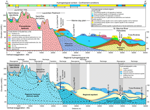
The northwest segment of the cross-section shows typical hydrogeological conditions in the Laurentian Hills. The surficial sediment cover is generally thin, and valleys formed along bedrock depressions are commonly floored by coarse permeable sediments that are locally overlain by fine-grained marine/estuarine sediments. Confined aquifers are locally present below the Champlain Sea sediments in valleys lying at the maximum marine limit. The Precambrian bedrock underlying the surficial sediment cover includes igneous/metamorphic rocks with no primary porosity and very low fracture porosity. It is considered an aquifer since water flows through it, but the capacity of the unit to yield an appreciable amount of groundwater ultimately depends on the interconnections of the fracture network, which tend to increase near the fault zones. In the northern part of the region, wells in bedrock commonly yield sufficient amounts of water for domestic supply, but sometimes have to be drilled to depths exceeding 40 m.
Along the edge of the Laurentian Hills, the Saint-Narcisse morainic complex has hydrogeological conditions conducive for groundwater extraction. The moraine and associated glaciofluvial deposits on both its proximal and distal boundaries contain a group of aquifers that generally are poorly connected, but nonetheless connected through low-permeability glacial sediments or bedrock. The municipalities of Notre-Dame-du-Mont-Carmel and St-Paulin both extract groundwater from this unit. The Charette segment of the morainic complex has a similar hydrogeological potential, with an unconfined upper aquifer and a confined lower aquifer, both of which are not utilized. A series of depressions above the St-Cuthbert fault are filled by sand and gravel that may contain productive aquifers bounded by the marine clay aquitard. These depressions have not yet been tested or exploited for a municipal water supply. Even though the hydrogeological potential of the St-Cuthbert fault area remains untested, it likely plays a key role in the regional flow system by intercepting groundwater flowing from the Precambrian Hills and redirecting groundwater into glacial sand and gravel aquifers in the adjacent Piedmont.
In the clay plain, the sediment cover is very thick but is almost exclusively composed of very fine-grained marine mud (silty clay) with very low permeability. The underlying till unit is more permeable than the Paleozoic bedrock by an order of magnitude, but is still not considered an aquifer. Groundwater within the sedimentary rocks below the Quaternary deposits is generally brackish. Because the rivers flowing across the plain tend to be deeply entrenched, the extent of alluvial aquifers is limited. However, the paleodeltas of the Maskinongé and Yamachiche rivers are large enough to contain significant groundwater supplies, and are used for a potable water supply by the towns of St-Édouard-de-Maskinongé, Ste-Ursule, St-Alexis-des-Monts, St-Élie-de-Caxton, Charette and St-Mathieu-du-Parc. Municipalities that are too far from the deltas are supplied by a private aqueduct network operated by the Régie d’Aqueduc de Grand-Pré, which pumps water from wells in glacial sand and gravel aquifers near St-Boniface.
The cross-section ends in the St-Maurice River paleodelta sandy aquifers (Figure ). This large deltaic system was built at the mouth of the valley during regression of the Champlain Sea and subsequent Lake Lampsilis. The delta overlies either marine clays or older Quaternary deposits. At St-Boniface and St-Étienne (upstream on the left bank), the deltaic deposits contain an unconfined aquifer which caps the stratigraphic sequence, but is too thin to supply large volumes of groundwater. In some areas, though, where thicker well-sorted sands occur, commonly in narrow erosional channels cut in the underlying clay, there may be sufficient water supply for municipalities. In the Trois-Rivières (downstream right bank) and Cap-de-la-Madeleine (downstream left bank) sectors, significant thickening of the surficial sand cover makes the aquifer much more productive. The St-Maurice River is deeply entrenched into its former delta, cutting through even the upper till layer and pre-LGM Quaternary units. This creates groundwater resurgences along the river. The City of Trois-Rivières pumps water from the surficial sand deposits on both sides of the St-Maurice. The sedimentary rocks underlying the Quaternary deposits are moderately permeable, but the water contained in the shale unit is mineralized and only used in a few geothermal applications.
Discussion and conclusion
3D model
As a result of its complex Quaternary history, the Mauricie region contains significant granular aquifers, such as the paleodelta of the St. Maurice and Yamachiche rivers, the Saint-Narcisse morainic complex and the high sandy terraces formed during Champlain Sea regression. These aquifers had been partially investigated through local hydrogeological studies conducted by municipalities. New fieldwork was undertaken to supplement existing data and to build a coherent hydrostratigraphical model presenting the stratigraphy and architecture of surficial deposits. Taking into account the reliability ratings, surfaces representing the upper and lower contacts of geological formations were modelled by cokriging. The result is a 3D model with seven layers representing the surficial deposits of the Mauricie region, from the surface of the bedrock to the upper littoral and deltaic sands. The total thickness of the sediments varies from zero, on rock outcrops, to 150 m under the City of Trois-Rivières.
The 3D hydrostratigraphical model has helped refine the understanding of regional aquifers, particularly the thickness, distribution and sequence of surficial deposits in the valleys, along the St. Cuthbert Fault, under the Saint-Narcisse morainic complex and in the paleodelta of the Saint-Maurice River. New, unexploited aquifers have been identified north of the City of Trois-Rivières, around the Saint-Narcisse morainic complex and along the St. Cuthbert Fault. The deposits of the St. Cuthbert Fault are confined aquifers resulting from the deposition of granular sediments into a series of bedrock depressions observed along the axis of the fault. These aquifers, as well as confined aquifers beneath the marine clay plain, are only known indirectly through the interpretation of geophysical surveys, such as seismic reflection profiling. Additional drilling is required to determine the grain size distributions of the deposits to assess aquifer potential.
Regional stratigraphy
The results of the 3D model are consistent with the regional stratigraphy proposed by Gadd and Karrow (Citation1959), Denis (Citation1972), and Occhietti (Citation1982). However, the modelling helped to further clarify the regional hydrostratigraphic framework, notably the topography of the bedrock surface, the subsurface extent of pre-LGM Quaternary sands, and the architecture of post-Champlain Sea deposits.
The pre-LGM Vieilles Forges sands were identified under the marine clay layer in borehole FE-02-11. This is the first drillhole that records the presence of this unit east of the St. Maurice River, and this allows us to better assess the extent of this regional unit. It is possible that some wells of the City of Trois-Rivières draw their water from this formation, rather than from the post-Champlain upper sands. Additional drilling (with dating) would be necessary to validate the extension of pre-LGM deposits north of Trois-Rivières. The permeability of these older deposits and the quality of the water they contain remain difficult to assess at a regional scale, as well as the hydraulic links between the upper sand aquifer and the bedrock.
Facies encountered in drilling along the Saint-Narcisse morainic complex vary widely. In general, the upper layer consists of coarse-grained sediments, from sand to cobbles and boulders, and is associated with ice retreat from the terminal moraine. This material generally lies above the groundwater table and is too coarse to form a reservoir, but it contributes to the overall recharge of the surrounding aquifers. Multiple stratigraphic wells drilled in the center of the Saint-Narcisse Moraine showed the presence of a layer of fine-grained sediments or diamicton (till) at the base, confirming that the material was emplaced in a marine environment during a re-advance of the ice sheet. Although the permeability of this unit is lower than that of the overlying coarse-grained material, it cannot be considered an aquitard due to its higher proportion of fine sand. However, a sandy aquifer confined below the marine fine-grained sediments was observed in some borings. For example, an aquifer contained in 20 m of medium sand was discovered when drilling borehole FE-09-11 in the village of Sainte-Angèle-de-Prémont. This deposit should be investigated further, given its positive aquifer characteristics.
The aquifer formed by the upper sands of the Trois-Rivières area is composed of a mixture of marine and lacustrine sands (littoral and deltaic), as well as sands associated with the paleodelta of the Saint-Maurice River. The unit rests on impermeable marine sediments on both sides of the river, but the thickness of the clay aquitard is much more variable on the west bank. The aquifer is highly stratified and encompasses many facies. Differentiating depositional environments based on grain-size characteristics has been attempted, but has not achieved much success. In terms of thickness and grain size, the western deltaic zone shows a greater aquifer potential than the eastern zone, and the observations show that the upper sand in the northern part of the city has greater-than-expected thicknesses.
This study has highlighted yet again the major hydrogeological potential of the Champlain Sea deltas in the St-Lawrence Valley (for example, see Fagnan et al. Citation1998 for the Portneuf delta). Those deltaic constructions were emplaced as laterally continuous and thick units in a postglacial sea where sediment supply as well as accommodation space were elevated. They were later dissected by the post-glacial incision caused by the glacial isostatic rebound. Similar contexts can be found all along the axis of the St-Lawrence River, particularly at the mouth of its left bank tributaries which were fed by abundant meltwaters and sediments derived from the receding Laurentide Ice Sheet.
Also highlighted were the few spatially disconnected buried valley aquifers around the Saint-Narcisse Moraine, showing the highly dynamic nature of the depositional process during this event. Similar buried aquifers can most likely be found close to the moraine outside the study area.
Acknowledgements
This work is part of the Groundwater Knowledge Acquisition Program (PACES) of the Quebec Ministry of the Environment (MDDELCC). It was conducted in collaboration with a regional council of elected officials (CRÉ Mauricie), regional municipalities (MRC Maskinongé), the city of Trois-Rivières, the Geological Survey of Canada and watershed agencies. The authors would like to acknowledge the Minivibe seismic profiling carried by André Pugin and Susan Pullan of the Geological Survey of Canada. We would also like to thank the municipal officials, the local residents and the following persons for their collaboration: Myrabelle Chicoine, Isabelle Lessard, Alain Rouleau, Ali Assani, Pierre-André Bordeleau, Francis Clément, Précillia Descoteaux, Sophie Côté, Éric Dubois, Brian Bélisle, Philippe Davignon, Fannie Fortier-Fradette, Lise Lamarche, Harold Vigneault, Marc-André Carrier, Miroslav Nastev, Claude Hébert, François Hardy, René Lefebvre, Jean-Marc Ballard and Xavier Mallet.
References
- Besré, F., and S. Occhietti. 1990. Les Varves de Deschaillons, les Rythmites du Saint-Maurice et les Rythmites de Leclercville, Pléistocène supérieur, vallée du Saint-Laurent, Québec [Late Pleistocene Deschaillons Varves, St. Maurice Rhythmites and Leclercville Rhythmites, St. Lawrence Valley, Québec]. Geographie physique et Quaternaire 44 (2): 181–198.
- Bolduc, A. M. 1999a. Géologie des formations superficielles: région de Shawinigan, Québec [Geology of Surface Formations: Shawinigan Area, Québec]. Map 2995, 1: 50 000 scale. Ottawa: Geological Survey of Canada.
- Bolduc, A. M. 1999b. Géologie des formations superficielles, région de Trois-Rivières, Québec. Ottawa [Geology of Surface Formations: Trois-Rivières Area, Québec]. Map 2994, 1: 50 000 scale. Ottawa, ON, Canada: Geological Survey of Canada.
- Chesnaux, R., M. Lambert, J. Walter, U. Fillastre, M. Hay, A. Rouleau, R. Daigneault, A. Moisan, and D. Germaneau. 2011. Building a geodatabase for mapping hydrogeological features and 3D modeling of groundwater systems: Application to the Saguenay–Lac-St-Jean region, Canada. Computers & Geosciences 37: 1870–1882.
- Clark, T. H., and Y. Globensky. 1976. Rapport géologique RG-164: Région de Trois-Rivières [Geological report RG-164 : Trois-Rivières Region]. Technical report and map. Quebec City, QC, Canada : Ministère des Richesses Naturelles, Direction générale des mines.
- Clet, M., and S. Occhietti. 1996. Géologie du quaternaire de la région de Saint-Gabriel-de-Brandon (moitié est), comtés Maskinongé, Berthier et Saint-Maurice : rapport préliminaire [Quaternary geology of the Saint-Gabriel-de-Brandon region (eastern part), Maskinongé, Berthier and St-Maurice counties : preliminary report]. Quebec, QC, Canada : Ministère des richesses naturelles, Direction générale des mines, Service de l'exploration géologique. 50 (3): 287–310.
- Denis, R. 1972. Géologie du quaternaire de la région de Saint-Gabriel-de-Brandon (moitié est), comtés Maskinongé, Berthier et Saint-Maurice: rapport préliminaire [Quaternary geology of the Saint-Gabriel-de-Brandon region (eastern part), Maskinongé, Berthier and St-Maurice counties: preliminary report]. Quebec, QC, Canada: Ministère des richesses naturelles, Direction générale des mines, Service de l'exploration géologique.
- Denis, R. 1974. Late Quaternary geology and geomorphology in the Lake Maskinongé area, Québec. PhD Thesis, University of Uppsala, 125 pp.
- Fagnan, N., Michaud, Y., Lefebvre, R., Boisvert, E., Parent, M., Martel, R., Paradis, D., and D. Larose-Charette. 1998. Cartographie hydrogéologique régionale du piémont laurentien dans la MRC de Portneuf : hydrostratigraphie et piézométrie des aquifères granulaires de surface [Regional hydrogeological cartography of the Laurentian piedmont in the Portneuf regional county municipality : hydrostratigraphy and piezometry of surficial granular aquifers]. Open File 3664b. Ottawa, ON, Canada: Geological Survey of Canada. doi:10.4095/210071.
- Ferland, P., and S. Occhietti. 1990. Révision du stratotype des Sédiments de Saint-Pierre et implications stratigraphiques, vallée du Saint-Laurent. Québec [Revision of the St. Pierre Sediments Stratotype and Stratigraphic Implications, St. Lawrence Valley, Québec]. Geographie physique et Quaternaire 44 (2): 147–158.
- Gadd, N. R., and P. F. Karrow. 1959. Surficial geology of Trois-Rivières: Saint-Maurice, Champlain, Maskinongé and Nicolet Counties, Québec. Geological Survey of Canada, 54-1959, map. doi:10.4095/108651
- Globensky, Y. 1987. Géologie des Basses-Terres du Saint-Laurent [St-Lawrence Lowlands geology]. Technical report with map. Quebec City, QC, Canada : Ministère de l'Énergie et des Ressources du Québec.
- Hardy, F., and M. Lamothe. 1997. Quaternary basin analysis using infrared stimulated luminescence on borehole cores and cuttings. Quaternary Science Reviews (Quaternary Geochronology) 16 : 417–426.
- Lamarche, L. 2005. Histoire géologique Holocène du lac Saint-Pierre et de ses ancêtres. Master’s thesis, Université du Québec à Montréal, 225 pp.
- McCormack, R. 1983. Étude hydrogéologique : Rive nord du Saint-Laurent [Hydrogeological study: North shore of the St-Lawrence River]. Technical report and 1:200 000 scale map. Quebec, QC, Canada: Ministère de l'Environnement, Service des eaux souterraines.
- Nadeau, L., and P. Brouillette. 1995. Carte structurale de la région de Trois-Rivières SNRC 31I: Province de Grenville, Québec [Structural map of the Trois-Rivières : (SNRC 31I) : Grenville Province, Québec.]. 1:250 000 scale map. Ottawa, ON, Canada & Quebec, QC, Canada: Geological Survey of Canada & Centre géoscientifique de Québec.
- Occhietti, S. 1980. Le Quaternaire de la région de Trois-Rivières - Shawinigan, Québec : contribution à la paléogéographie de la vallée moyenne du St-Laurent et corrélations stratigraphiques [The Quaternary record of the Trois-Rivières - Shawinigan area, Quebec - contribution to the paleogeography of the St-Lawrence mid-valley and stratigraphic correlations]. PhD thesis, Université du Québec à Montréal, 230.
- Occhietti, S. 1982. Synthèse lithostratigraphique et paléoenvironnements du Quaternaire au Québec méridional [Lithostratigraphic Synthesis and Quaternary Paleoenvironments in Southern Québec]. Géographie Physique et Quaternaire 36 (1–2): 15–49.
- Occhietti, S. 2007. The Saint-Narcisse morainic complex and early Younger Dryas events on the southeastern margin of the Laurentide Ice Sheet. Geographie Physique et Quaternaire 61 (2): 89–117.
- Parent, M., and S. Occhietti. 1988. Late Wisconsinan deglaciation and Champlain Sea invasion in the St. Lawrence Valley, Québec. Géographie physique et Quaternaire 42 (3): 215–246.
- Parent, M., and S. Occhietti. 1999. Late Wisconsinan deglaciation and glacial lake development in the Appalachians of southeastern Québec. Géographie Physique et Quaternaire 53 (1): 117–135.
- Prévôt, J. M. 1972. Carte hydrogéologique des Basses Terres du St-Laurent [Hydrogeological Map of the St.Lawrence Lowlands]. Map 1748. Quebec, QC, Canada: Ministère des Richesses naturelles du Québec.
- Ross, M., M. Parent, and R. Lefebvre. 2005. 3D geologic framework models for regional hydrogeology and land-use management: A case study from a Quaternary basin of southwestern Québec, Canada. Hydrogeology Journal 13: 690–707.