
Abstract
Human activities have transformed the landscape and altered geochemical pathways through intensive land uses such as agriculture and urbanization. This study quantified the individual and cumulative influence of land-use drivers on nutrient concentrations for 29 Ontario tributaries flowing to Lake Erie and Lake Huron. For each watershed, measures of agriculture, urbanization and population served by municipal sewage treatment plants were quantified at multiple spatial scales; stream-water nutrients (nitrogen, N, and phosphorus, P) were sampled on 10 occasions between May and November 2012, and were also compiled from government records for concurrent (2012) and prior (2007, 2008, 2011) years. Application of ordinary least squares regression analysis showed that in 2012, concentrations of N and P (total as well as dissolved forms) were primarily driven by sewage treatment and urban activity, with agricultural activity as a secondary influence on variability. Evaluation of model predictive performance under scenarios of varying climate (wet, dry and ‘normal’ conditions) and spatial coverage (i.e. broader than the original sampling sites) showed that stream nitrogen concentrations could be predicted, on average, 36–85% of the time; phosphorus forms were, however, not successfully predicted, likely due to differences in sampling frequency relative to runoff events. The finding that both urban and agricultural land-use activities influence nutrient concentrations in Canadian tributaries to lakes Erie and Huron underscores the need to reduce both point and non-point inputs in order to mitigate eutrophication of downstream lakes.
Les activités humaines ont transformé le paysage et modifié les réseaux géochimiques par une occupation intensive du sol, par exemple agricole et urbaine. L’étude quantifie l’incidence individuelle et cumulative des facteurs d’utilisation des terres sur les concentrations d’éléments nutritifs dans 29 affluents ontariens des lac Érié et Huron. Pour chaque bassin versant, les activités agricoles et urbaines et les populations desservies par les stations municipales de traitement des eaux usées ont été quantifiées à de multiple échelles spatiales; les éléments nutritifs (azote [N] et phosphore [P]) dans les cours d’eau ont été échantillonnés à 10 reprises entre mai et novembre 2012, et les données tirées de registres gouvernementaux pour la même année (2012) et des années antérieures (2007, 2008, 2011) ont été recueillies. Une analyse ordinaire de régression des moindres carrés a montré qu’en 2012, les concentrations de N et de P (totaux et dissous) étaient principalement attribuables aux effluents du traitement des eaux usées et de l’activité urbaine. L’activité agricole avait une incidence secondaire sur la variabilité des concentrations. L’évaluation de la capacité prédictive du modèle selon divers scénarios de climat (conditions humides, sèches et « normales ») et diverses couvertures spatiales (plus grandes que les stations d’échantillonnage) a montré que les concentrations d’azote dans les cours d’eau pouvaient être prévues, en moyenne, entre 36 et 85 % du temps; par contre, le modèle n’a pas réussi à prévoir les concentrations des formes de phosphore, en raison des différences dans la fréquence d’échantillonnage en cas d’événements de ruissellement. La constatation que les utilisations agricoles et urbaines des terres influent sur les concentrations d’éléments nutritifs dans les affluents canadiens des lacs Érié et Huron fait ressortir le besoin de réduire les apports ponctuels et diffus afin d’atténuer l’eutrophisation des lacs en aval.
Introduction
Addition of nutrients, primarily phosphorus (P) and nitrogen (N), to fresh waters has resulted in widespread eutrophication which, in turn, has contributed to degraded water quality for drinking water and recreational uses, and impairments to ecological functioning of both lakes and inflowing waterways (Hilton et al. Citation2006; Scavia et al. Citation2014; Smith et al. Citation2015). The association between stream water quality and anthropogenic land use, particularly urban and agricultural activities, has been well documented (e.g. Omernik Citation1977; Johnson et al. Citation1997; Carpenter et al. Citation1998; Paul and Meyer Citation2001; Chambers et al. Citation2008; Robertson and Saad Citation2011). Land-use change alters the magnitude and timing of nutrient loss from a watershed, resulting in dramatic changes in the physico-chemical conditions of streams and rivers (Carpenter et al. Citation1998; Allan Citation2004). Determining the influence of land-use practices on stream nutrient concentrations is, therefore, critical for the management of water quality and mitigation of eutrophic and hyper-eutrophic conditions.
Non-point sources of nutrients include agriculture and urbanization, both of which contribute nutrients to surface waters through surface and subsurface runoff (i.e. flow in the unsaturated zone, above the water table and ground water transport) following snowmelt and precipitation events (Carpenter et al. Citation1998; Paul and Meyer Citation2001; Withers et al. Citation2003; Rattan et al. Citation2017). In agriculturally dominated regions, common agricultural practices, such as application of fertilizers and manure, can introduce excess nutrients into an ecosystem (Carpenter et al. Citation1998; Withers et al. Citation2003; Allan Citation2004). Crop cover and tile drainage alter the interaction of water with the landscape, increasing runoff, altering flow pathways and further enhancing delivery of nutrients to the river network (Johnson et al. Citation1997; Billy et al. Citation2013). In urban areas, impervious surface cover also enhances the delivery of fertilizers, detergents and solvents (all sources of nutrients) to surface waters (Paul and Meyer Citation2001; Allan Citation2004). The cumulative effects of these land-use changes and associated elevated nutrient loads can include excessive growth or changes in the relative abundance of algae and macrophytes. Such alterations to the gross primary productivity of streams can increase production and, more worryingly, consumption of oxygen, potentially leading to dangerously low oxygen concentrations for higher organisms such as fish (Hudon and Carignan Citation2008; Sánchez-Pérez et al. Citation2009). Although the effects of urban land use are largely driven by weather (e.g. Janke et al. Citation2014), the impacts of agricultural land-use change from year to year as a result of variation in both management practices and climate (e.g. Bosch et al. Citation2014). Hence, the influence of non-point sources on water quality varies spatially throughout a watershed due to variation in land-use and land-management practices, and temporally as a result of annual, seasonal and event-scale changes in meteorological conditions and the interaction with changing land management.
In addition to non-point sources, wastewater treatment facilities, such as sewage treatment plants and sewage lagoons, act as large point sources of nutrients to surface waters (Chambers et al. Citation1997; Paul and Meyer Citation2001; EPA Citation2004). Sewage treatment plants (STPs) remove varying proportions of N and P as well as other pollutants and reduce the biological oxygen demand of wastewater prior to discharge back into the aquatic ecosystem. Tertiary treatment offers the highest removal of nutrients with removal efficiency up to 90% of P, whereas lagoons and STPs providing secondary treatment achieve removal efficiencies of 90% biochemical oxygen demand, 75% suspended solids and 30% P under optimal conditions (Freedman Citation1995). Sewage lagoons rely on long holding times (typically months) for biological degradation to occur; heavy or sustained precipitation events or population growth beyond facility capacity can result in the discharge of partially treated wastewater (Paul and Meyer Citation2001). Thus, depending on the type of treatment and climatic factors as well as the size and mixing characteristics of the receiving water, the nutrients in wastewater discharged from lagoons and STPs can have varying influence on the biological oxygen demand, primary productivity and dissolved oxygen concentrations of aquatic ecosystems (Davies-Colley et al. Citation1995).
Urban, rural and agricultural activities are typically scattered throughout watersheds; hence, the spatial scale used to describe land-use development can strongly influence the nature and extent of association between land use and stream chemistry. At small spatial scales (e.g. stream reach), effects of local management practices such as the extent of riparian buffer strips and tillage practices can be detected (Yates et al. Citation2007, Citation2014), while at larger spatial scales (e.g. entire watershed) broader influences such as watershed land uses may be detected (Dodds and Oakes Citation2008) or, conversely, may be masked as a result of changes in water availability (Yates et al. Citation2014). Previous studies have found that increasing proportions of agricultural and urban land use at the reach scale are positively correlated with stream N and P concentrations (Carpenter et al. Citation1998; Banner et al. Citation2009). For example, Banner et al. (Citation2009) showed that total P concentrations were significantly associated with the proportion of cropland in the riparian zone in streams located in Kansas. Similarly, vegetated riparian buffers have been found to significantly reduce the transport of nutrients to rivers by enhancing assimilation of nutrients into plant tissues and also by acting as barriers between the landscape and stream during overland and runoff flows (e.g. Chase et al. Citation2016). These studies suggest that land use proximal to the stream can disproportionately influence nutrient retention on (or loss from) the land and thus the amount of nutrients and sediment transported to the stream. As such, studies of stream water quality should quantify land use at multiple spatial scales to ensure all key relationships between land use and stream quality are captured.
To advance the goal of the Canada–USA Great Lakes Water Quality Agreement (1972, and amended most recently in 2012) to reduce the quantity of nutrients entering Lake Erie, managers require knowledge of linkages between land-use activities and stream-water nutrient concentrations. A predictive model that relates stream nutrient concentrations to land use would enable managers to identify areas within watersheds that may be significant contributors of nutrients and would benefit from focused management actions (e.g. application of beneficial management practices, sewage treatment upgrading, etc.). The goal of this study was to quantify the cumulative influence of spatial patterns in land use and wastewater discharge on nutrient concentrations (N and P) in tributaries of the Great Lakes, in particular lakes Erie and Huron. Using regression models, the relationships between human activities and stream nutrient concentrations were identified based on field data collected from May through November 2012. The potential of the regression models as stream management tools applicable to other southwestern Ontario watersheds and years with different weather conditions was then examined by assessing the predictive performance of the nutrient models outside the spatial and temporal bounds for which they were created.
Methods
Study area
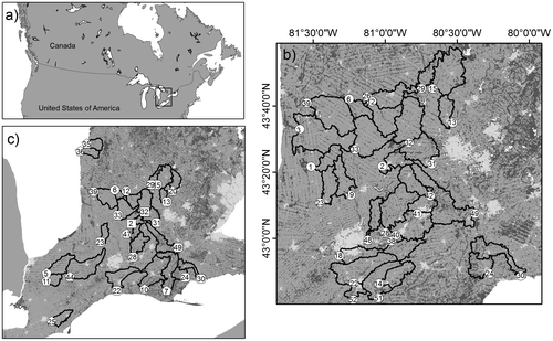
Twenty-nine Great Lakes watersheds (area range: 106–571 km2) were selected in the mixed-wood plains ecozone (Crins et al. Citation2009) of southwestern Ontario (Figure a and b). Watersheds were selected on the basis of: (1) inclusion in the Ontario Ministry of Environment and Climate Change Provincial Water Quality Monitoring Network (PWQMN); (2) watershed size (100–750 km2); (3) land use (i.e. to represent as wide a gradient as possible in urban and agriculture land use and wastewater discharge; Figure c); (4) physiography (i.e. surface geology characterized by glacial till); and (5) logistical requirements, notably permission to access.
Figure 1. Maps showing: (a) Location of study area (black square) in relation to Great Lakes; (b) the 29 study watersheds with corresponding sampling site (white circles); and (c) evaluation sites (square – data integrity sites only; octagon – temporal integrity sites only; pentagon – spatial integrity sites only; rounded square – data and temporal integrity sites).
All 29 watersheds are characterized by a humid, temperate climate with mean annual temperatures ranging from 4.9 to 9.4°C (Crins et al. Citation2009). Annual precipitation ranges from 720 to 1000 mm and is typically evenly distributed throughout the year (67–99 mm per month; Crins et al. Citation2009), though in the sampling year (2012) total annual precipitation was 24% less than the long-term mean (722 compared to 953 mm) with rain events largely confined to June/July and September/October. Study watersheds all drain into Lake Huron or Lake Erie and are underlain by glacial deposits with predominately glacial till and silt substrate (Crins et al. Citation2009). Although woodlands typified the native vegetation prior to the nineteenth century, settlement has transformed these into agricultural fields dominated by small grains, corn, soybean and hay crops. The dominant land use in the region, by area, is agriculture, which represents 57–78% of the land cover in the entire area and is comprised of upward of 44% cropland (Crins et al. Citation2009).
Major urban centers in the region include London (population 366,151), Kitchener (219,153), Cambridge (126,748) and Waterloo (98,780), and all experienced population growth of 1.0–7.1% between 2006 and 2011 (Statistics Canada Citation2011). Smaller centers (i.e. population < 12,000) often experienced even larger population growth rates, with two communities (New Hamburg and Drayton) exhibiting population growth rates > 10% (Statistics Canada Citation2011). Wastewater management infrastructure for the larger urban centers consists of secondary mechanical treatment, whereas wastewater from rural communities or smaller urban centers is treated in lagoons that are typically licensed to discharge effluent in spring and fall.
Water sampling
Water quality sampling was conducted approximately every 3 weeks from May to November 2012 for a total of 10 water samples per site. Grab water samples were collected in the thalweg at approximately 60% water depth and analyzed for major forms of P, namely total phosphorus (TP), total dissolved phosphorus (TDP), soluble reactive phosphorus (SRP), and N, namely dissolved Kjeldahl nitrogen (DKN), total nitrogen (TN), ammonia (NH3), and nitrate-nitrite (NO3 + NO2). One high-density polyethylene bottle (1 L) was filled and the water was field filtered (with 0.45-μm cellulose acetate filter paper) into sterile Flint glass bottles (125 mL) for analysis of NO3 + NO2, NH3, DKN, TDP and SRP. All samples were stored at approximately 4°C in a cooler and transported overnight to the National Laboratory for Environmental Testing (NLET) in Burlington, Ontario, for analysis following standard protocols (Environment Canada Citation1994). Concentrations of dissolved organic nitrogen (DON), dissolved inorganic nitrogen (DIN) and total dissolved nitrogen (TDN) were subsequently calculated from measured N forms. Calculated TDN values (DKN + [NO3 + NO2]) were sometimes slightly larger than measured TN due to the differing analytical methods used to measure the various N forms.
Land use and human activity descriptions
Watershed boundaries for the 29 watersheds were delineated using ArcGIS 10.0 (ERSI Citation2010a), extension ArcHydro 2.0 (ESRI Citation2010b). Delineation was based on the NASA’s Advanced Spaceborne Thermal Emission and Reflection Radiometer (ASTER) digital elevation model (DEM) imagery and the National Hydro Network stream layer for Southern Ontario. Land-use descriptions were calculated for all watersheds based on a 2012 crop inventory map (30-m resolution) obtained from Agriculture and Agri-Food Canada (ftp://ftp.agr.gc.ca/pub/outgoing/aesb-eos-gg/Crop_Type_Mapping/2012/, accessed August 2013). The 2012 crop inventory map was re-classed using ArcGIS 10.0 (ESRI Citation2010a) to produce five classes of land use (forage crop, row crop, tile drainage, and impervious and pervious land use). The intersect polygon raster tool (insectpolyrst) function in Geospatial Modelling Environment (Hawthorne Citation2012) was then used to determine the proportion of forage crop, row crop, and impervious and pervious land upstream of each sampling site at four spatial scales: (1) the entire watershed area; (2) a 30-m stream buffer along the entire stream network (entire stream buffer; Barton Citation1996; Dodds and Oakes Citation2008); (3) a 30-m buffer for headwater streams only (headwater buffer; Strahler order 1 and 2; sensu Dodds and Oakes Citation2008); and (4) a 30-m sampling reach buffer extending 600 m upstream of the site (600-m buffer). The total area of agricultural land drained by tiles was determined for each watershed using the Ontario Ministry of Agriculture, Food and Rural Affairs (OMAFRA) tile drainage data in ArcGIS 10.0.
Sewage discharge to the 29 watersheds was summarized as three descriptors. First, the distance (m) from the sampling site to the nearest upstream STP was calculated using ArcGIS 10.0 Origin to Destination Cost Matrix function (ESRI Citation2010b). Second, the population served by STPs (sewage treatment population density) was calculated for each watershed by dividing the population served by STPs (2011 Canadian population census data; Statistics Canada Citation2011) by watershed area. Third, the volume of effluent discharged from STPs in a watershed was summed from monthly values (May–November 2012) included in annual wastewater reports submitted by each facility to the Ontario Ministry of Environment and Climate Change.
Data analysis
Descriptive statistics were calculated for all dependent (i.e. water quality) and independent (i.e. land use) variables. In 2012, only two water chemistry variables had values below analytical detection limits: 5.9% of NH3 and 0.3% of SRP values were below detection. For these samples, the detection limit value was assigned as the true value (NH3 = 0.005 mg/L; SRP = 0.0002 mg/L). Normality was assessed for water quality and land-use descriptors across sites using box plots, z-scores and the Shapiro–Wilk test for normality. All data were transformed to improve normality: nutrient and sewage treatment (population density and distance upstream) data were log10(x + 1) transformed; agriculture (forage, row crop) and urban (impervious and pervious) land-use data were transformed with inverse sine. Pearson correlation analysis (α = 0.05) identified multi collinearity among land-use descriptors, expressed as the variance inflationary factor (VIF, 1/[1 − r2]; Levine et al. Citation2004). A conservative criterion of VIF > 5 was adopted to identify descriptors exhibiting collinearity (Levine et al. Citation2004).
Associations between land use and water chemistry variables were examined using ordinary least squares regression analysis (OLS). Regressions were performed using mean May–November 2012 nutrient concentrations for each site (n = 29). OLS regression global models were run independently for each nutrient variable to identify significant relationships between nutrients and all land-use descriptors. Normality of the global models was assessed using the Shapiro–Wilks test of normality as well as assessment of residual plots. Outliers identified by the OLS regression analysis were removed from the data set (outlier = absolute studentized residual > 2.8). All global models were found to be significant and met requirements of normality. Forward selection was applied to the OLS regression models (probability to enter and leave = 0.15) for each individual nutrient variable to identify significant land-use descriptors, thus generating seven nutrient models. OLS bootstrap re-sampling (10,000 samples) was then used to identify the upper and lower bounds of the standardized coefficients and assess the confidence of the model based on the variance of the explanatory variables (α = 0.05), reported using the percentile method. The statistical program SYSTAT 12 (SYSTAT software 2009) was used for all statistical analyses.
Predictive analysis and model evaluation
Model evaluation was undertaken to assess the robustness of the nutrient models in predicting average May through November nutrient concentrations under conditions not captured by the 2012 data. To accomplish this, a second database was assembled of nutrient concentrations measured as part of the PWQMN (https://www.ontario.ca/data/provincial-stream-water-quality-monitoring-network, accessed August 2013). No water chemistry variables extracted from the PWQMN database were below detection limits.
First, the robustness of the models to variations in data integrity was assessed. The models were based on grab samples collected by Western University and Environment Canada and Climate Change employees and analyzed at Environment Canada and Climate Change’s NLET; the PWQMN measurements were from grab samples collected by Province of Ontario or Conservation Authority staff and analyzed at the Ontario Ministry of Environment and Climate Change. The PWQMN database was queried for sites that were common to the field program and that were also sampled: (1) systematically (i.e. at regular intervals); (2) on a minimum of five occasions between May and November 2012; and (3) at least once during each season. This resulted in the identification of 13 common sites with four comparable parameters: NO3 + NO2, TP, SRP and TN (calculated as the sum of unfiltered TKN and NO3 + NO2 for the PWQMN sites). Data from the PWQMN sites were averaged for the period May–November 2012 and compared to expected nutrient concentrations calculated using the OLS regression models.
Second, because models were developed from 2012 data, model performance associated with inter-annual variation in nutrients was assessed (i.e. temporal robustness). Temporal evaluation of model performance was conducted under three climatic scenarios (i.e. wet, dry and moderate years) allowing the identification of strengths and limitations of model predictive power associated with differences in annual climatic conditions. Three environmental characteristics were used to identify years between 2002 and 2012 with distinct climatic conditions: May–November total precipitation (London, Ontario, meteorological station 6144473, World Meteorological Organization ID: 71623) and May–November average daily discharge for the Thames and Grand rivers (Water Survey of Canada stations 02GD015 and 02GA034). Average daily temperature was excluded from the analysis due to low variation among years (mean = 14.96; Standard Deviation (SD) = 0.64; Coefficient of Variation (CV) = 0.043). K-means cluster analysis grouped the 2002–2012 precipitation and discharge data into three distinct clusters. Cluster 1 contained mid-range values for precipitation and discharge and was classified as moderate climatic years (Table ). Cluster 2 exhibited the highest values for precipitation and discharge and was classified as wet years, whereas Cluster 3 had the lowest precipitation and discharge values and was classified as dry years. Querying the PWQMN database for the period 2002–2012 identified the years 2007 (dry), 2008 (moderate) and 2011 (wet) as having the most sites (n = 14) in common with the field program. Mean May–November nutrient concentrations were calculated for each PWQMN site for every test year (2007, 2008 and 2011). The 2006 Canadian population census data was used to calculate population density served by STP for each watershed for the 2007 (dry) and 2008 (moderate) years, whereas 2011 census population data was used to calculate population density served by STP for the 2011 (wet) year. Expected nutrient concentrations were calculated for each PWQMN site for 2007, 2008 and 2011 by entering the associated land-use data into the 2012 models.
Table 1. Results from K-means cluster analysis classifying years based on climate and discharge averages for the May through November sample season [mean (standard deviation)]. The mean and standard deviation for precipitation and discharge data associated with each cluster were used to identify dry, moderate and wet years.
Third, the robustness of the models to variations in land-use coverage (i.e. spatial robustness) was assessed. From the PWQMN database, sites were selected that had: (1) no overlap of watershed boundary with the 29 watersheds; (2) sufficient data to allow calculation of average nutrient concentrations (i.e. minimum of five samples between May and November 2012, and at least one sample from each season); and (3) proportions of urban and agricultural land use and sewage treatment population densities that fell within the ranges of the 29 watersheds. This resulted in a total of 10 PWQMN sites with similar physiographic characteristics as the sites used to build the models. Land-use descriptors for the PWQMN sites were then entered into the derived OLS regression models and expected nutrient concentrations were calculated for each of the spatial validation sites.
For each site, observed:expected (O:E) scores were calculated and used to evaluate the similarity between the observed and predicted nutrient concentrations. Expected nutrient concentrations were then compared to the observed concentrations from the PWQMN database. Sites were considered to be successfully predicted when the O:E score fell between 0.8 and 1.2 (as recommended by the River Invertebrate Prediction and Classification System [RIVPACS] General Quality Agreement and Environmental Quality Index; Wright et al. Citation2000). The benefit of site O:E scores is the ability to identify model over- or under-prediction at specific sites. Sites that are consistently over- or under-predicted can then be further assessed to identify factors such as land use or management practices that may be further driving nutrient concentrations.
Results
Average nutrient concentrations
Average (May–November 2012) nutrient concentrations varied substantially among the 29 study sites (Figures ). Concentrations of TN ranged from 1.85 to 13.8 mg/L and were comprised mainly of dissolved forms of N, notably DIN which averaged 85% of TN. For any given site, mean NO3 + NO2 concentrations did not exceed a combined drinking water quality guideline of 11 mg/L (10 mg/L nitrate-N and 1 mg/L nitrite-N; Health Canada Citation2013) or the Canadian water quality guideline for short-term exposure of 12.4 mg/L nitrate-N (CCME Citation2012); however, 76% of site means exceeded the Canadian water quality guideline for long-term exposure of 3 mg/L nitrate-N (CCME Citation2012).
Figure 2. Mean concentrations of measured stream nitrogen variables from study streams (total nitrogen, dissolved Kjeldahl nitrogen, nitrate-nitrite, ammonia, dissolved organic nitrogen, dissolved inorganic nitrogen, total dissolved nitrogen) represented as box and whisker plots. Sample size = 29 for all variables.
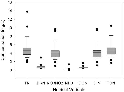
Figure 3. Mean concentrations of measured stream phosphorus variables from study streams (total phosphorus, total dissolved phosphorus, soluble reactive phosphorus) represented as box and whisker plots. Sample size = 29 for all variables.
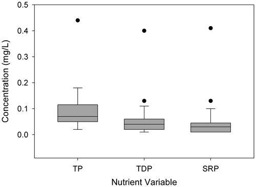
Similarly, TP concentrations ranged from 0.02 to 0.18 mg/L and were comprised primarily of dissolved forms, which averaged 63% of TP (Supplemental Table 1). Of the 29 streams sampled, 25 streams exceeded the threshold of 0.035 mg/L TP between mesotrophic and eutrophic conditions recommended under the Canadian Environmental Quality Guidelines (CEQG; CCME Citation2004).
Land-use descriptors
The proportion of agriculture measured as forage (7.4–29%) and row crop (40–81%), the percentage of watershed area that was tile drained (7.2–75%), and the extent of urban activity measured as pervious (0.05–4.8%) and impervious (0.5–13%) land use varied substantially among the 29 watersheds (Figure c; Tables ). Comparison of the four spatial scales showed that row crops dominated at the entire watershed, entire stream buffer and headwater buffer scales (52–65%), with forage representing a moderate areal extent (15–19%) followed by low percentages of urban land (< 2.5% for pervious or impervious). In contrast, the 600-m buffer captured roughly similar extents of forage and row crop coverage (17 and 12%, respectively). STP descriptors demonstrated greater variability than land-use descriptors did. Of the STP descriptors, total effluent volume exhibited the greatest variability (CV = 1.9) followed by STP population density (CV = 1.3).
Table 2. Agricultural land-use descriptors described at multiple landscape scales for catchments and riparian buffer areas (30 m width) of 29 stream sites located on lower Great Lakes tributaries in southwestern Ontario, Canada.
Table 3. Urban land-use and sewage treatment plant descriptors described at multiple landscape scales for catchments and riparian buffer areas (30 m width) of 29 stream sites located on lower Great Lakes tributaries in southwestern Ontario, Canada.
Analysis of collinearity using VIF scores identified significant collinearity between spatial scales for a given land use or STP descriptor (Table ). Pervious land use in the entire stream buffer, impervious land use at both the entire stream buffer and at the headwater buffer scales, and forage and row crops at the headwater buffer scale were found to be collinear (VIF > 5) with the same land-use categories at the watershed scale. Similarly, pervious and impervious land use in headwater stream buffers were collinear with these land covers at the entire stream buffer scale. Based on the criteria for collinearity (VIF > 5), all seven land-use descriptors were removed from further analyses (pervious land use at the entire stream buffer scale, impervious land use at both the entire stream buffer and headwater stream buffer scales, forage and row crop at the headwater stream buffer scale). Although pervious land use at the headwater stream buffer scale was significantly collinear with pervious land use at the watershed scale, it was retained for further analyses because the VIF score < 5.
Table 4. Variance Inflation Factor (VIF) scores for 29 watersheds in southwestern Ontario indicating the degree of collinearity between the proportion of (a) pervious, (b) impervious, (c) forage and (d) row crop land use quantified for the entire watershed, entire stream buffer, headwater buffer, and 600-m buffer. Also shown for the same watersheds are variance inflation factor scores for measures of sewage release (effluent volume, sewage treatment plant population density and river distance to nearest sewage treatment plant). * identifies regressions with P > 0.95.
Assessment of the descriptors for sewage treatment showed significant collinearity between effluent volume and sewage population density (Table ). Although the VIF scores were < 5, effluent discharge was removed from further analyses because effluent volume showed a slightly stronger association with distance than distance showed with sewage population density.
OLS regression models
OLS regression analysis identified several significant relationships between nutrients and land-use descriptors (global F sig. p < 0.05; Table ). Following forward selection procedures, the resulting models varied from 46% (NO3 + NO2) to 82% (DON) in the amount of variability described by land use and STP descriptors. Each model included four to eight significant descriptors and incorporated a measure of both agricultural (forage, row crop or tile drainage) land use and urban (pervious or impervious) land use or STP activity. Measures of urban extent and STP activity had larger standard coefficients than agricultural parameters for all models, with the exceptions of NO3 + NO2 and TDP.
Table 5. Results of ordinary least squares regression analyses relating average May–November nutrient concentrations to land-use descriptors for 29 southwestern Ontario watersheds. Outliers are identified by site number in order of exclusion.
For models predicting N, measures of STP population density or urban land use in the watershed were the most significant descriptors, with the exception of NO3 + NO2 (DIN could not be successfully modelled). In the case of dissolved N fractions, STP population density and forage within the entire stream buffer (NO3 + NO2, which represents the majority of DIN) or within the 600-m buffer (DON) were the most significant descriptors, with almost equal standard coefficients. Forage at the entire stream buffer scale was also a significant descriptor for DON, but with a 1.5–3.5-fold smaller standard coefficient. Both NO3 + NO2 and DON had negative relationships to forage at the entire stream buffer scale, and positive relationships with all other descriptors. The most important descriptors for DKN (another measure of organic N) were STP population density and STP distance from the site. For all other N parameters (NH3, TN and TDN), measures of urban pervious and impervious land use were the most significant descriptors. Both TDN and TN had strong negative relationships with the proportion of pervious land use within the headwater buffers.
For all models predicting P, STP density and the proportion of forage within both the entire stream buffer and the 600-m buffer were significant descriptors. For TDP, the proportion of forage within the 600-m buffer was the most important descriptor, but strong relationships were also found with STP population density (positive relationship) and the proportion of forage along the entire stream buffer (negative relationship). For the other forms of P (SRP and TP), STP population density was the most significant descriptor, but the proportion of forage within the 600-m buffer and within the entire stream buffer were also important. Similar to TDP, the proportion of forage within the entire stream buffer had a negative relationship to SRP and TP. The model for TP was the weakest of the three P models, with only 71% of variation explained compared to 77% explained for SRP and 80% for TDP.
Model performance and evaluation
Evaluation of the robustness of the NO3 + NO2, TN, SRP and TP models using the three types of model evaluation scenarios (data integrity, spatial integrity and temporal integrity) revealed that model performance varied between N and P forms. Based on measures of overall model performance, N models exhibited stronger performance than P models did for all scenarios, with average O:E ratios ranging from 0.89 to 25.28 (Table ). Based on an acceptance criterion of 0.8–1.2 for mean O:E, N models for all three temporal integrity scenarios were successful. Moreover, examination of individual watersheds showed that only six sites displayed less than two successful predictions under all model performance scenarios (Sites 6, 12, 23, 28, 30, 33; Figures ). Under spatial scenarios, only two sites (25, 35) showed poor model performance for both NO3 + NO2 and TN; an additional four sites (5, 11, 20, 36) were unsuccessful for NO3 + NO2 whereas all other sites were successfully predicted for TN (Figures ).
Table 6. Performance of regression models developed using 2012 data from 29 Great Lakes watersheds under three scenarios: data integrity, spatial integrity, and temporal integrity (the latter for dry, moderate and wet years). Performance is expressed as the ratio of observed values to model predictions (i.e. observed:expected, O:E) for nitrate-nitrite, total nitrogen, soluble reactive phosphorus and total phosphorus, averaged for all the watersheds (sample size) for which predictions were made. Success is a measure of the number of successful predictions (0.8 ≤ O:E ≤ 1.2) for each scenario and nutrient parameter.
Figure 4. Results of site observed:expected scores for the assessment of predictive performance under data and temporal integrity scenarios (dry, moderate and wet). Black boxes indicate no data were available; grey boxes represent scenarios where site observed:expected scores fell within 20% of 1.0 (0.8–1.2).
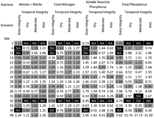
Figure 5. Results of site observed:expected scores for the assessment of predictive performance under the spatial scenario. Grey boxes represent scenarios where site observed:expected scores fell within 20% of 1.0 (0.8–1.2).

In contrast to the N model scenarios, only two of the 10 P scenarios (namely data integrity and spatial scenarios for SRP) met the acceptance criteria (Table ). Although on average, the model for data integrity failed for TP, six of the 13 individual sites passed. For all other SRP and TP model scenarios that on average failed (SRP: temporal; TP; spatial and temporal), only 1–5 of the 14 (temporal) or two of 10 (spatial) individual sites passed.
Discussion
Analysis of N and P concentrations for 29 streams located in the Canadian portion of the Lake Erie and Lake Huron watersheds showed that both urban activity (expressed as percentage pervious and impervious land use in the watershed or population served by sewage treatment) and agriculture land use (in particular percentage forage) were dominant land-use descriptors accounting for variability in stream nutrients. OLS regression analysis explained 55–88% of the variability in nine of 10 nutrient parameters (NH3, DKN, NO3 + NO2, TN, DON, TDN, TDP, SRP and TP), with urban activity often being the most significant explanatory variable. Under the Great Lakes Water Quality Agreement (1972), the governments of Canada and the United States agreed that TP concentrations were not to exceed 1 mg/L in effluent from sewage treatment plants discharging > 1 million gallons per day to the Great Lakes or its tributaries and connecting rivers. In 1994, the Province of Ontario broadened this decision such that all sewage treatment works were required to provide secondary treatment or equivalent as the normal level of treatment, with TP < 1 mg/L in the final effluent (Ontario MOE Citation1994). Yet despite long-standing controls of P in sewage effluent, the models identified sewage (expressed as population served by sewage treatment and distance from the nearest STP) or urban area (expressed as percentage of pervious or impervious land use) as having higher standard coefficient values than most measures of agriculture. The results indicate that the population density served by an STP, and urban land use (rather than agriculture), were the main drivers of N and P concentrations in southwestern Ontario streams, suggesting that despite improvements in effluent quality, point sources such as wastewater treatment facilities influence regional stream nutrient concentrations, especially under low-flow conditions.
The finding that urban activity (population served by sewage treatment or urban land use) was a more important descriptor of stream nutrients than agricultural land use is consistent with patterns in N and P concentrations measured at the study sites. Although sites downstream of sewage treatment plants versus ones in predominately agricultural watersheds had, on average, similar concentrations of TP (sites downstream of STP = 0.088 mg/L; sites not downstream of STP = 0.090 mg/L), 95% of sites downstream of sewage treatment plants exceeded the CEQG meso-eutrophic upper threshold of 0.035 mg/L (CCME Citation2004), compared to 63% of sites in agricultural settings. For N, the percentage of sites that exceeded the Canadian water quality guideline for long-term exposure of nitrate-N (3 mg/L) was almost identical for sites downstream of sewage treatment plants and in agricultural settings (76% and 75%, respectively). While urban (as opposed to agricultural) activity had greater influence on stream nutrient concentrations in the 2012 study year, the authors acknowledge the importance of managing both non-point and point urban and agricultural sources of nutrients. A combination of agricultural beneficial management practices (e.g. grassed waterways, conservation tillage and basin-wide stream bank stabilization) and improved point-source management can typically achieve greater nutrient reduction as, for example, was modelled for the Genesee River, the second highest river load to Lake Ontario (Makarewicz et al. Citation2015).
Previous studies have suggested that stream concentrations of TN and TP in lower Great Lakes watersheds are related to the extent of agricultural land use (Chambers et al. Citation2008; Robertson and Saad Citation2011; Makarewicz et al. Citation2015). In a region similar to that of the present study, Chambers et al. (Citation2008) showed that TN and TP concentrations at 177 stream sites in southwestern Ontario were associated with the percentage of cropland in the catchment, and identified a rapid increase in TN and TP concentrations with increases in percentage cropland above 82%. Others have also observed associations between stream concentrations of TN and TP and agricultural activity in the drainage basin, linking this to enriched runoff resulting from application of fertilizer and manure (Withers et al. Citation2003; Yuan et al. Citation2013). In the models developed here, the agricultural descriptors with the highest coefficients of variation were often measures of forage, not row crop or tile drainage. In particular, the extent of forage along a buffer within 600 m upstream of the site had strong positive relationships with the nutrient variables, indicating increasing nutrient concentrations with increasing forage at a local scale. Forage was defined as the coverage of both pasture land and hay fields for the specified scale (e.g. entire watershed vs. entire stream buffer). The importance of forage (particularly forage close to the stream channel), as opposed to row crops, in the models may be due in part to the fact that 2012 was a slightly drier than normal year (24% less precipitation than the long-term mean). Row crop coverage was considerably less in the buffer immediately upstream of the sampling sites (on average, 11.5% of a buffer within 600 m upstream of sites compared to 52–65% at other scales); hence, the lower runoff in 2012 may have reduced the influence of row crops (located at a greater distance from the stream channel) on water chemistry. The importance of forage in the models highlights the necessity of managing manure contamination of streams from either direct (livestock crossing) or indirect (manure on pasture lands and application to hay fields) sources, particularly during drier years.
Assessment of the robustness of the nutrient models in predicting average (May through November) nutrient concentrations under conditions not captured by the 2012 data showed that the models successfully predicted stream N (TN, NO2 + NO3) concentrations 43 to 80% of the time, with average O:E ratios meeting the acceptance criterion of 0.8–1.2 under all three integrity scenarios (data, temporal and spatial integrity). This finding suggests that application of the models could be extended to predict regional effects of urban development and agricultural land-use change on stream N concentrations, both now and under future climate scenarios. However, it is noteworthy that the models better predicted N concentrations that were within one standard deviation of the mean of the data used to derive the models (i.e. mean 5 ± 2 mg/L N, mean ± standard deviation), suggesting future N models should incorporate more sites with extreme N concentrations.
In contrast with the robust stream N models, P concentrations were not successfully predicted. The data integrity models typically over-predicted P values (54–69% of sites), while the temporal and spatial models typically under-predicted P values (57–86% of sites). Model strength did not appear to influence performance as SRP and TP models exhibited R2 values greater than, or similar to, R2 values for TN and NO3 + NO2 models (Table ). Evaluation of laboratory methods showed that the two labs (National Laboratory for Environmental Testing and Ontario Ministry of Environment and Climate Change) used similar analytical methods (i.e. digestion and colorimetry) and held Canadian accreditation for these parameters. The results showed that TN consisted almost exclusively of dissolved forms (TDN/TN = 0.99), whereas TP was comprised of 65% dissolved P. Because particulate nutrients are transported to streams during runoff events whereas dissolved forms can be delivered continuously through seepage and groundwater inputs (e.g. Sharpley et al. Citation1994; Hansen et al. Citation2002), the disparity in predictive performance between the N and P models is likely due to the effect of differences in sampling frequency between the two agencies in relation to the transport of particulate P during runoff events. In 2012, sampling was completed on 10 occasions, with 1–4 of these 10 sampling events occurring within 1 week of a rain storm, whereas PWQMN sampled on 6–8 occasions with 0–3 sampling dates occurring during the week following a rain event and three sites with no sampling during the week following a rain event. These findings emphasize the need to standardize sampling design when comparing total and particulate P concentrations and loads temporally (i.e. among seasons or years) or spatially (i.e. among sites).
Although regression models are not indicative of causality, the results show that both urban activity (expressed as sewage discharge and pervious and impervious land use) and, to a lesser extent, agricultural land use (in particular forage) influenced N and P concentrations in Canadian tributaries to Lake Erie and Lake Huron during May–November 2012. These results highlight the influence of fugitive nutrient sources (such as forage) under conditions of low runoff generation – sources which may well be overlooked under differing climatic conditions (e.g. high precipitation years). The findings also highlight the need to standardize sampling design when comparing nutrient concentrations and loads temporally or spatially, particularly for nutrient fractions that represent or include particulate forms. Strengthening the models (particularly for P) by including a larger range of conditions (spatially and temporally) to improve predictive performance would allow them to serve as tools to identify watersheds where management actions could be focused, thus enabling more cost-efficient and effective mitigation of land-based nutrient sources.
Funding
Funding for this study was provided by Environment Canada’s Great Lakes Nutrient Initiative, an NSERC Discovery Grant to Adam G. Yates and an NSERC Visiting Fellowship in Canadian Government Laboratories to Kathryn Thomas.
Acknowledgments
We thank Erika Hill and Zoey Duggan for assistance with field sampling and logistical support.
References
- Allan, J. 2004. Landscapes and riverscapes: The influence of land use on stream ecosystems. Annual Review of Ecology, Evolution and Systematics 35: 257–284.10.1146/annurev.ecolsys.35.120202.110122
- Banner, E. B., A. J. Stahl, and W. K. Dodds. 2009. Stream discharge and riparian land use influence in-stream concentrations and loads of phosphorus from central plains watersheds. Environmental Management 44 (3): 552–565.10.1007/s00267-009-9332-6
- Barton, D. R. 1996. The use of percent model affinity to assess the effects of agriculture on benthic invertebrate communities in headwater streams of southern Ontario, Canada. Freshwater Biology 36 (2): 397–410.10.1046/j.1365-2427.1996.00053.x
- Billy, C., F. Birgand, P. Ansart, J. Peschard, M. Sebilo, and J. Tournebize. 2013. Factors controlling nitrate concentrations in surface waters of an artificially drained agricultural watershed. Landscape Ecology 28 (4): 665–684.10.1007/s10980-013-9872-2
- Bosch, N. S., M. A. Evans, D. Scavia, and J. D. Allan. 2014. Interacting effects of climate change and agricultural BMPs on nutrient runoff entering Lake Erie. Journal of Great Lakes Research 40: 581–589.10.1016/j.jglr.2014.04.011
- Environment Canada. 1994. Manual of Analytical Methods: Major Ions and Nutrients. vol. 1. Burlington, Ontario, Canada: National Laboratory for Environmental Testing, Canadian Centre for Inland Waters.
- Carpenter, S. R., N. F. Caraco, D. L. Correll, R. W. Howarth, A. N. Sharpley, and V. H. Smith. 1998. Nonpoint pollution of surface waters with phosphorus and nitrogen. Ecological Applications 8 (3): 559–568.10.1890/1051-0761(1998)008[0559:NPOSWW]2.0.CO;2
- CCME (Canadian Council of Ministers of the Environment). 2004. Canadian water quality guidelines for the protection of aquatic life: Phosphorus, Canadian guidance framework for the management of freshwater systems. In Canadian Environmental Quality Guidelines, ed. Canadian Council and of Ministers of the Environment, 1–6. Winnipeg, MB, Canada: Canadian Council of Ministers of the Environment.
- CCME (Canadian Council of Ministers of the Environment). 2012. Canadian water quality guidelines for the protection of aquatic life: Nitrate. In Canadian Environmental Quality Guidelines, 1–17. Winnipeg, MB, Canada: Canadian Council of Ministers of the Environment.
- Chambers, P. A., M. Allard, S. L. Walker, J. Marsalek, J. Lawrence, M. R. Servos, J. Busnarda, et al. 1997. The impacts of municipal wastewater effluents on Canadian waters: A review. Water Quality Research Journal of Canada 32 (4): 659–713.
- Chambers, P. A., C. C. Vis, R. B. Brua, M. Guy, J. M. Culp, and G. A. Benoy. 2008. Eutrophication of agricultural streams: Defining nutrient concentrations to protect ecological condition. Water Science & Technology 58 (11): 2203–2210.10.2166/wst.2008.815
- Chase, J. W., G. A. Benoy, S. W. R. Hann, and J. M. Culp. 2016. Small differences in riparian vegetation significantly reduce land use impacts on stream flow and water quality in small agricultural watersheds. Journal of Soil and Water Conservation 71 (3): 194–205.10.2489/jswc.71.3.194
- Crins, W. J., P. A. Gray, P. Uhlig, and M. C. Wester. 2009. The Ecosystems of Ontario, Part 1: Ecozones and Ecoregions. Science and Information Branch, Inventory, Monitoring and Assessment Section. Ontario: The Ontario Ministry of Natural Resources.
- Davies-Colley, R. J., C. W. Hickey, and J. M. Quinn. 1995. Organic matter, nutrients, and optical characteristics of sewage lagoon effluents. New Zealand Journal of Marine and Freshwater Research 29 (2): 235–250.10.1080/00288330.1995.9516657
- Dodds, W. K., and R. M. Oakes. 2008. Headwater influences on downstream water quality. Environmental Management 41 (3): 367–377.10.1007/s00267-007-9033-y
- EPA (Environmental Protection Agency). 2004. Primer for Municipal Waste Water Treatment Systems. Document no. EPA 832-R-04-001. Washington, DC.
- ESRI (Environmental Systems Resource Institute). 2010a. ArcMap 10.0. Redlands, California: ESRI.
- ESRI (Environmental Systems Resource Institute). 2010b. ArcHydro 2.0. Redlands, California: ESRI.
- Freedman, B. 1995. Environmental Ecology, Second Edition: The Ecological Effects of Pollution, Disturbance, and Other Stresses, 195. San Diego, CA: Academic Press Inc.
- Hansen, N. C., T. C. Daniel, A. N. Sharpley, and J. L. Lemunyon. 2002. The fate and transport of phosphorus in agricultural systems. Journal of Soil and Water Conservation 57 : 408–417.
- Hawthorne, L.B. 2012. Geospatial Modelling Environment. Spatial Ecology LLC.
- Health Canada. 2013. Guidelines for Canadian Drinking Water Quality: Guideline Technical Document - Nitrate and Nitrite. Water and Air Quality Bureau, Healthy Environments and Consumer Safety Branch, Health Canada.
- Hilton, J., M. O’Hare, M. J. Bowes, and J. Iwan Jones. 2006. How green is my river? A new paradigm of eutrophication in rivers. Science of The Total Environment 365 : 66–83.10.1016/j.scitotenv.2006.02.055
- Hudon, C., and R. Carignan. 2008. Cumulative impacts of hydrology and human activities on water quality in the St. Lawrence river (Lake Saint-Pierre, Quebec, Canada). Canadian. Journal of Fisheries and Aquatic Science 65 (6): 1165–1180.10.1139/F08-069
- Janke, B. D., J. C. Finlay, S. E. Hobbie, L. A. Baker, R. W. Sterner, D. Nidzgorski, and B. N. Wilson. 2014. Contrasting influences of stormflow and baseflow pathways on nitrogen and phosphorus export from an urban watershed. Biogeochemistry 121: 209–228.10.1007/s10533-013-9926-1
- Johnson, L. B., C. Richards, G. Host, and J. W. Arthur. 1997. Landscape influences on water chemistry in Midwestern stream ecosystems. Freshwater Biology 37 (1): 193–208.10.1046/j.1365-2427.1997.d01-539.x
- Levine, D. M., D. Stephan, T. C. Krehbiel, M. L. Berenson, and J. G. Bliss. 2004. Statistics for Managers, Using Microsoft Excel. Canadian ed. Toronto: Pearson Education Canada Inc..
- Makarewicz, J. C., T. W. Lewis, M. Winslow, E. Rea, L. Dressel, D. Pettenski, B. J. Snyder, P. Richards, and J. Zollweg. 2015. Utilizing intensive monitoring and simulations for identifying sources of phosphorus and sediment and for directing, siting and assessing BMPs: The Genesee River example. Journal of Great Lakes Research 41 : 743–759.10.1016/j.jglr.2015.06.004
- Omernik, J. M. 1977. Non-Point Source-Stream Nutrient Level Relationships: A Nationwide Study. USEPA Ecological Research Series EPA- 600/3-77-105, 138. Corvallis, OR: USEPA.
- Ontario MOE (Ontario Ministry of Environment and Energy). 1994. Water Management Policies and Guidelines, Provincial Water Quality Objectives of the Ministry of Environment and Energy PIBS 3303E. Ontario: Queen’s Printer for Ontario.
- Paul, M. J., and J. L. Meyer. 2001. Streams in the urban landscape. Annual Review of Ecology, Evology and Systematics 32 : 333–365.10.1146/annurev.ecolsys.32.081501.114040
- Rattan, K. J., J. C. Corriveau, R. B. Brua, J. M. Culp, A. G. Yates, and P. A. Chambers. 2017. Quantifying seasonal variation in total phosphorus and nitrogen from prairie streams in the Red River Basin, Manitoba Canada. Science of The Total Environment 575 (1): 649–659.10.1016/j.scitotenv.2016.09.073
- Robertson, D. M., and D. A. Saad. 2011. Nutrient inputs to the Laurentian Great Lakes by source and watershed estimated using SPARROW watershed models. Journal of the American Water Resources Association 47 (5): 1011–1033.10.1111/j.1752-1688.2011.00574.x
- Sánchez-Pérez, J. M., M. Gerino, S. Sauvage, P. Dumas, E. Maneux, F. Julien, P. Winterton, and P. Vervier. 2009. Effects of wastewater treatment plant pollution on in-stream ecosystems functions in an agricultural watershed. Annales de Limnologie – International Journal of Limnology 45 (2): 79–92.10.1051/limn/2009011
- Scavia, D., J. D. Allan, K. K. Arend, S. Bartell, D. Beletsky, N. S. Bosch, S. B. Brandt, et al. 2014. Assessing and addressing the re-eutrophication of Lake Erie: Central basin hypoxia. Journal of Great Lakes Research 40 : 226–246.10.1016/j.jglr.2014.02.004
- Sharpley, A. N., S. C. Chapra, R. Wedepohl, J. T. Sims, T. C. Daniel, and K. R. Reddy. 1994. Managing agricultural phosphorus for protection of surface waters: Issues and options. Journal of Environmental Quality 23 : 437–451.10.2134/jeq1994.00472425002300030006x
- Smith, A. J., B. T. Duffy, and M. A. Novak. 2015. Observer rating of recreational use in wadeable streams of New York State, USA: Implications for nutrient criteria development. Water Research 69 : 195–209.10.1016/j.watres.2014.11.022
- Statistics Canada. 2011. Census profile – population center, Alymer, Arthur, Belmont, Clinton, Elmira, Exeter, Ingersoll, Listowel, Lucan, Milverton, Mitchell, Mount Elgin, Seaforth, Simcoe, (London) Southland, Stratford, Strathroy, St. Thomas, Thamesford, Townsend, Waterford, Wellesley, Wilmot, Woodstock, Vanastra (2006-2011). [Data file]. E-STAT. http://estat.statcan.ca.
- Withers, P. J. A., B. Ulen, C. Stamm, and M. Bechmann. 2003. Incidental phosphorus losses – are they significant and can they be predicted? Journal of Plant Nutrition and Soil Science 166 (4): 459–468.10.1002/(ISSN)1522-2624
- Wright, J. F., D. W. Sutcliffe, and M. T. Furse. 2000. Assessing the biological quality of freshwaters: RIVPACS and other techniques, 1–26. Ambleside: Freshwater Biological Assn.
- Yates, A. G., R. C. Bailey, and J. A. Schwindt. 2007. Effectiveness of best management practices in improving stream ecosystem quality. Hydrobiologia 583 (1): 331–344.10.1007/s10750-007-0619-4
- Yates, A. G., R. B. Brua, J. Corriveau, J. M. Culp, and P. A. Chambers. 2014. Seasonally driven variation in spatial relationships between agricultural land use and in-stream nutrient concentrations. River Research and Applications 30 (4): 476–493.10.1002/rra.v30.4
- Yuan, Y., M. A. Lockeb, R. L. Bingnerb, and R. A. Rebich. 2013. Phosphorus losses from agricultural watersheds in the Mississippi Delta. Journal of Environmental Management 115: 14–20.10.1016/j.jenvman.2012.10.028