Abstract
CORALNet-UBC was installed in April 2008 as a “proof of concept” and the first facility in a proposed cross-Canada network of similar lidars. Despite its location on the wet West Coast of Canada, data recovery ranged from a low of 45% of the total time in December, when heavy snowfall interrupted operations, to a high of 90% in July. The facility has been a spectacular success in terms of its operational characteristics (as measured by data recovery), the range of phenomena observed and the research that it has spawned. Examples are provided of the types of phenomena observed since its initial deployment. These include observations of boundary layer structure, cloud signatures, forest fire plumes and evidence of singular long-range pollutant and volcanic transport events. Observations from CORALNet-UBC complement data from other aerosol measurement initiatives in the region and provide a rich source of information that is relevant to researchers, operational forecasters and air quality managers. Future research will be directed at elucidating the processes and phenomena revealed by the instrument as well as developing new products that exploit the real-time forecasting and public advisory potential of the facility.
R ésumé [Traduit par la rédaction] Le lidar CORALNet-UBC a été installé en avril 2008 comme une « démonstration de faisabilité » et constitue le premier élément d'un réseau de lidars semblables proposé pour couvrir le Canada. Malgré son emplacement sur la pluvieuse côte ouest du Canada, la récupération des données a varié d'un minimum de 45 % du temps total en décembre, alors que de fortes chutes de neige ont interrompu les opérations, à un maximum de 90 % en juillet. L'installation s'est avérée un succès spectaculaire du point de vue de ses caractéristiques d'exploitation (telles que mesurées par la récupération des données), de la gamme des phénomènes observés et de la recherche qu'elle a engendrée. Nous présentons des exemples des types de phénomènes observés depuis sa mise en place initiale. Ceux-ci comprennent des observations de la structure de la couche limite, de signatures de nuages, de panaches de feux de forêt et de manifestations d'événements singuliers de transport de polluants et de cendre volcanique à grande distance. Les observations du CORALNet-UBC s'ajoutent aux données d'autres projets de mesure d'aérosols dans la région et fournissent une riche source d'information utile pour les chercheurs, les prévisionnistes opérationnels et les gestionnaires de la qualité de l'air. Les recherches futures viseront à élucider les processus et les phénomènes que révèle l'instrument ainsi qu'à mettre au point de nouveaux produits permettant de tirer profit des capacités de l'installation en ce qui a trait à la prévision en temps réel et à l'émission d'avis pour le public.
Keywords:
1 Introduction
Application of ground-based, upward-pointing lidar to the continuous observation of the lower atmosphere has become increasingly common and sophisticated in recent years (Mattis et al., Citation2008; Morille et al., Citation2007; Baars et al., Citation2008; Rauthe et al., Citation2008). Rich datasets produced by these systems provide opportunities to study myriad phenomena at a range of scales. Examples include the detection of boundary layer height and structure (Baars et al., Citation2008; Brooks et al., 2003; McKendry et al., Citation2009; Morille et al., Citation2007; Steyn et al., Citation1999) and cloud base (Morille et al., Citation2007; Pal et al., Citation1992; Wang and Sassen, Citation2001) and, with Raman Lidar, the structure of frontal systems (Melfi et al., Citation1989; Sakai et al., 2005) and gravity waves (Rauth et al., 2008). Lidar can also elucidate singular events such as dust storms, biomass burning plumes and even firework plumes (Müller et al., Citation2005; van der Kamp et al., Citation2008; Tratt et al., Citation2001; Murayama et al., Citation2001). Furthermore, with appropriate processing, lidar observations can be used to reveal important physical characteristics of aerosols (e.g., depolarization data can be used to deduce particle shape and hence provenance of particles).
In this paper we describe the permanent deployment of a continuous, automonous, upward-pointing lidar in Vancouver, British Columbia, as part of the Canadian Operational Research Lidar Network (CORALNet). On the basis of one year of continuous operation, we provide a preliminary overview of performance characteristics and provide an illustrated inventory of phenomena of interest observed during this first year of deployment. In so doing, we demonstrate the broad applications of the facility and suggest possible future research directions.
2 Background
a Geography and Meteorology
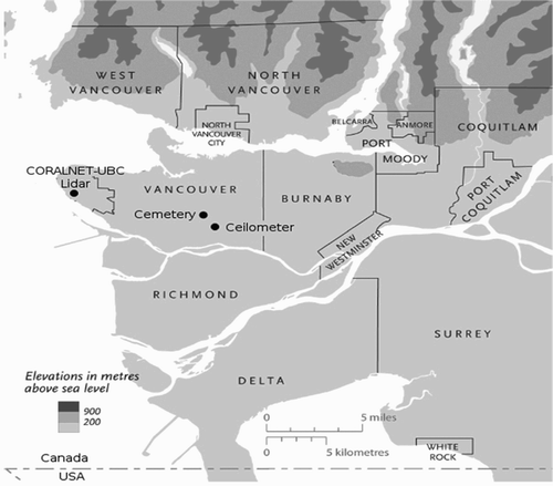
Vancouver (49.5oN, 123oW) is a coastal city, part of a larger metropolitan area with a population exceeding two million inhabitants. It is located at the western edge of the triangle-shaped Lower Fraser Valley and is bounded on the western side by the Strait of Georgia, immediately west of the CORALNet-UBC location, which separates the mainland from Vancouver Island (). Winds in the region are strongly influenced by thermo-topographic effects and include significant channelling of flow (30% of winds come from the east) as well as the presence of thermally induced circulations such as sea and land breezes and slope and valley winds.
Fig. 1 Map showing the western Lower Fraser Valley and sites mentioned in the text.
Extensive field studies during summer (e.g., Banta et al., Citation1997; McKendry et al., Citation1997, Citation1998) have demonstrated the presence of complex wind patterns driven by land-water contrasts and mountain effects. This complexity has been notoriously difficult to reproduce in model simulations (e.g., Steyn and McKendry, Citation1988) and is known to be responsible for the creation and advection of elevated pollutant layers (McKendry and Lundgren, Citation2000).
With a west coast location, few industrial or solid fuel home-heating sources and abundant winter rainfall, particulate matter (PM) concentrations are relatively low compared to many industrialized mid-latitude cities. Mean annual PM10 concentrations are approximately 15 µg m−3 with maximum hourly values reaching approximately 50 µg m−3 during periods of reduced dispersion, primarily during occasional summer photochemical smog events (McKendry, 2000).
b Lidar
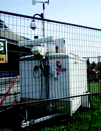
CORALNet-UBC (Environment Canada, 2008) is located at the western edge of the city of Vancouver on the grounds of the University of British Columbia (UBC) in close proximity to the Strait of Georgia (). The remotely controlled permanent facility is housed in a cargo trailer with modifications including a roof hatch assembly, a basic meteorological tower, a radar interlock system (this disables the instrument when aircraft or birds are overhead), a climate control system and levelling stabilizers (). The unit can be operated through an internet link and requires an external power source. A precipitation sensor is used to operate the roof hatch and three pan/tilt webcams capture sky conditions and monitor the health of the lidar system. A remote control interface is used to control all vital components of the system and can be used to provide hard resets of the laser electronics.
Fig. 2 CORALNet-UBC trailer installation at Totem Field (University of British Columbia).
A Continuum Inlite III (small footprint) laser operating at 1064/532 nm simultaneously with a pulse repetition rate of 10 Hz is the foundation of the system. The energy output is approximately 150 mJ at 532 nm and 130 mJ at 1064 nm. The upward pointing system emits two wavelengths and measures a return signal at three channels (1064 nm, 532 nm, both polarizations). Backscatter information is collected at a vertical resolution of 3 m with 10 s averaging from near the ground to 15 km.
Ground-based lidar networks such as CORALNet complement and provide important “ground-truthing” for the new generation of satellite aerosol instruments. A milestone in the satellite remote sensing of aerosols occurred in April 2006 when the Cloud-Aerosol Lidar and Infrared Pathfinder Satellite Observation (CALIPSO) was launched to fly in formation with the A-train satellites; CALIPSO carries the Cloud-Aerosol Lidar with Orthogonal Polarization (CALIOP) instrument. CALIOP along with the Moderate Resolution Imaging Spectroradiometer (MODIS) provide an unprecedented capability for monitoring global aerosols (including clouds).
Transmitted lidar emits nearly 100% polarized light. However, the return signal may be significantly depolarized depending on the shape of the aerosols responsible for backscattering. Consequently, the volume depolarization ratio provides a very useful means by which to discriminate between ice and water clouds and between aerosols having irregular shapes and those that are spherical. This property is a useful component of aerosol detection algorithms such as those used with the CALIPSO instruments (Vaughn et al., 2009) and, in the context of this study, provides a basis for discriminating between smoke and dust plumes in lidar imagery. Previous studies suggest that depolarization from ice crystals is of the order of 30–50%, whereas for spherical water droplets depolarization is approximately zero (i.e., the original polarization of the lidar beam is preserved (Sassen, Citation2000)). Smoke plumes from biomass burning typically have values of 0-10% (Murayama et al., 2003) but may be as high as 10–20% (Hoff et al., Citation2007; Sassen, Citation2000). Typically, the irregular shape of crustal dust aerosol produces significantly higher depolarization ratios (>20%; Murayama et al., Citation2004). In this paper, depolarization results for specific cases are presented for demonstration purposes. However, this product is not currently available online, but research is currently underway to make it an operational product and add it to the online catalogue.
3 Results
a Operational Statistics
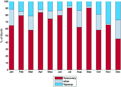
Continuous lidar operations commenced on 16 April 2008 with ancillary instruments (anemometer, thermometer, barometer and rain detector) coming online on 5 May 2008. For the purpose of this study, only data collected from 5 May 2008 to 13 May 2009 are considered. Monthly data recovery statistics are shown in . The percentage of time lost due to precipitation (when the rain sensor triggers the lidar to stop and the trailer window hatch to close for a minimum of 20 minutes) is shown in blue. Minimum time lost to rain occurred in July (6%) with a maximum in November (32%). Further operational time (grey in ) was lost due to maintenance (e.g., weekly cleaning of window, parts replacement and quarterly maintenance visits), system failure or when the radar interlock detected aircraft overhead. Notably, in December 2008 the system was shut down for a week while roof heat strips and circuitry were added to melt snow and ice around the hatch. A further week was lost during March 2009 due to the replacement of the trailer. Other downtime was primarily associated with laser failures. On this basis, total data recovery (and hence lidar operation) ranged from a low of 45% in December, when heavy snowfall interrupted operations, to a high of 90% in July.
Fig. 3 Data recovery statistics CORALNet-UBC for the period April 2008–May 2009. Blue represents time lost because of precipitation and grey the time lost due to maintenance and other reasons (e.g., aircraft adjacent to beam). Red is the total percentage of data recovered.
b Examples of Phenomena Observed
1 Boundary Layer Height and Elevated Layer Structures
The height of the boundary layer, for both the daytime convective and the nocturnal stable cases, is a parameter with important air quality implications. Previous studies, based primarily on intensive observation periods, have revealed spatial patterns in boundary layer depths over the Lower Fraser Valley (Steyn, Citation1980; Strawbridge and Snyder, Citation2004; Batchvarova et al., Citation1999) as well as identifying the importance of elevated layer structures over the region (McKendry et al., Citation1997; Maletto et al., Citation2003; McKendry and Lundgren, Citation2000; McKendry et al., Citation2009).
Detection of daytime mixed layer height (MLH) by lidar is dependent on there being sufficient aerosol in the boundary layer to be able to distinguish the mixed layer from the free troposphere. Application of algorithms that diagnose MLH is complicated by cloud and precipitation development, as well as the presence of elevated layer structures and residual layers. The latter are particularly relevant during nocturnal hours and provide a significant obstacle to the routine diagnosis of nocturnal boundary layer heights. With respect to daytime MLH, a total of 47 days (13%) were identified in the first year of operation when clear skies prevailed (10 in spring, 29 in summer, 4 in fall, 4 in winter) and boundary layer detection algorithms might be usefully applied. Algorithms developed for the detection of the MLH height for the CL31 ceilometer 8 km to the southeast () are described by van der Kamp and McKendry Citation(2010) and are currently being adapted for routine application to the CORALNet-UBC data.
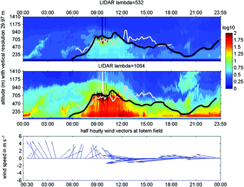
In , typical boundary layer development during clear-sky conditions is shown for 15 April 2009. The colour palette represents aerosol backscatter, with warm colours indicating high aerosol concentration and cold colours indicating weak backscatter from aerosols. The grey line shows the MLH diagnosed from the CL31 ceilometer using standard algorithms (van der Kamp and McKendry, Citation2010) and the black line the lidar-based MLH. Wind vectors are shown in the bottom panel and indicate offshore winds for the entire period with a switch from southerly flows to easterly winds at around midday. With winds from the south and east, MLH height is similar to or greater than that observed by the ceilometers shown in . This contrasts with the cases of onshore flow (not shown here) when the MLH is considerably lower or undetectable. Although not shown in this case, a common feature observed at CORALNet-UBC during the first year of operation was a peak in MLH heights before midday (rather than mid-afternoon when maximum thermal forcing might be expected). This is the subject of further investigation, but we propose that this effect may, in many cases, be associated with the onshore advection of cleaner air and lower MLHs with sea breeze onset. In addition, the 15 April example (a) demonstrates the feasibility of using the 1064/532 nm CORALNet lidar to detect boundary layer structure and MLH height at high resolution, (b) confirms the presence of elevated nocturnal pollution layers, and (c) suggests the potential for spatial analyses of boundary layer processes based on a network of lidars and ceilometers (as discussed by McKendry et al. Citation(2009)).
Fig. 4 Boundary Layer Development Case study—532 nm (top panel) and 1064 nm (middle panel), CORALNet-UBC lidar imagery for 15 April 2009. Wind vectors from the same location are shown in the bottom panel. The thick black lines indicate the diagnosed Mixed Layer Height (MLH) at CORALNet-UBC while the solid grey line is the MLH diagnosed at the ceilometer location approximately 8 km to the east. Note: the backscatter ratio (colour palette) is unitless. It represents the ratio of the backscatter coefficient of the aerosols to clear air.
2 Cloud Signatures Associated with Frontal Onset
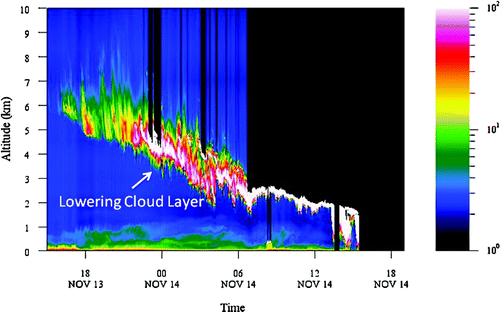
Approaching frontal systems on the west coast of British Columbia are usually characterized by lowering and thickening of the cloud cover over several hours ending in the onset of precipitation from nimbostratus cloud. This familiar sequence is readily apparent in the catalogue of lidar imagery as a signature in which a cloud layer lowers, over approximately 24 hours, in a broad linear fashion with the sequence ending in lidar shutoff as precipitation commences. A typical example from 13–14 November 2008 is shown in . Over the first year of operation fourteen obvious cases were observed with events occurring in all seasons (with a peak in spring 2009 when six events were observed). Research is currently underway to classify these cases and develop forecasting products that might exploit this signature in real-time for the forecasting of precipitation onset.
Fig. 5 CORALNet-UBC 1064 nm lidar data for 14 November 2008 showing the signature of the lowering cloud deck associated with an approaching frontal system. Note: the backscatter ratio (colour palette) is unitless. It represents the ratio of the backscatter coefficient of the aerosols to clear air.
3 Trans-Pacific Dust Transport
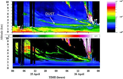
Beginning with the well-documented 1998 Asian dust episode, a growing inventory of trans-Pacific dust events affecting North America has been established. Most of these events occur during spring and have involved sources in the Gobi and Takla Makan deserts in Asia (Thulasiraman, 2002; McKendry et al., Citation2008; Leaitch et al., Citation2009); although recently a case of Saharan dust transport across Asia and the Pacific to North America was documented based on observations from the mobile predecessor to the current CORALNet-UBC lidar (McKendry et al., Citation2007). Since initial deployment, CORALNet-UBC has provided an unprecedented opportunity to identify important aspects of trans-Pacific dust transport. In addition to identifying particular events, lidar information has elucidated the height of transport and the nature of meteorological processes of subsidence and mixing that affect ground level concentrations (and potentially human health).
A moderate Asian dust event from 26 April 2008 is shown in . The subsiding dust layer is labelled in the top panel and is confirmed by global dust model simulations (Naval Research Laboratory, Navy Aerosol Analysis and Prediction System (NRL NAAPS)) and by dust storm observations in China. This particular example demonstrates the utility of depolarization data from CORALNet (bottom panel) in inferring the sources and physico-chemical characteristics of aerosol layers. Comparison of both panels indicates that the thin subsiding dust layer shows values of aerosol backscatter similar to the aerosol in the boundary layer (i.e., yellow and red hues in the top panel) whereas the boundary layer and dust layer are markedly different with respect to depolarization (bottom panel). Aerosol depolarization for this subsiding layers is in the range 0.18–0.35 (18–35%) and is consistent with values measured elsewhere for Asian dust (e.g., Murayama et al., 2003; Sakai et al., Citation2003). These high values of depolarization are indicative of non-spherical crustal particles and are easily distinguished from depolarization ratios for local anthropogenic pollution and biomass burning plumes (see example below). More detailed comparisions of CORALNet depolarization data with CALIPSO data are provided in McKendry et al. Citation(2010).
Fig. 6 CORALNet-UBC 1064 nm (top panel) and depolarization (bottom panel) for 26 April 2008 showing subsiding Asian dust layers. Note: the backscatter ratio (colour palette) is unitless. It represents the ratio of the backscatter coefficient of the aerosols to clear air.
4 Regional Forest Fire Plumes
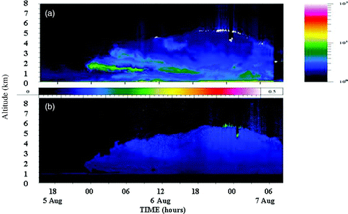
Wildfire activity in northern California during summer 2008 burned approximately 3,244.47 km2 (worst on record) and included over 2,780 individual fires. A series of fires was triggered in northern California by lightning on 20 June and these continued to burn throughout the summer. In early July and then again in early August, southerly winds carried dense smoke from the various fire complexes northward into Oregon, Washington State and British Columbia. Satellite based smoke detection products (NOAA, 2010) show extensive smoke haze spreading into southwestern British Columbia during the periods 30 June to 3 July and 4 to 7 August. The Hybrid Single Particle Lagrangian Integrated Trajectory (HYSPLIT) mode back-trajectories for both cases indicate southerly flow and subsidence over the region (Draxler and Rolph, 2010; Rolph, 2010).
In , aerosol backscatter (panel a) and depolarization at 532 nm (panel b) are shown for the smoke event beginning on 6 August 2008. Although distinct layers are evident (green hues at approximately 2000 m in panel (a) smoke extended through a depth of approximately 6000 m at CORALNet-UBC where it was capped by a subsidence inversion. In contrast to the Asian dust case described earlier, depolarization ratios (panel b) show little variability through the depth of the smoke haze layer and are approximately in the range 0.07–0.14 (7–14%) (depicted by blue hues) These values are again consistent with values observed elsewhere (Reid et al., Citation2005a, Citation2005b) and confirm that smoke particles are broadly spherical. More detailed examination of this case is provided in McKendry et al. Citation(2010).
Fig. 7 CORALNet-UBC 1064 nm (a) and depolarization (b) for the California biomass burning event on 5–7 August 2008. Note: the backscatter ratio (colour palette) is unitless. It represents the ratio of the backscatter coefficient of the aerosols to clear air.
5 Volcanic Events
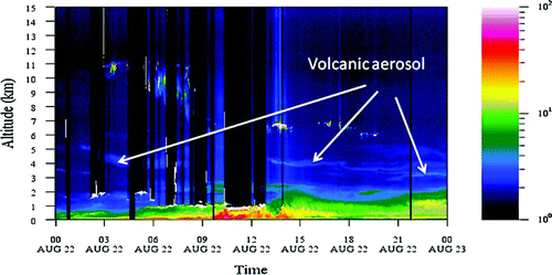
In addition to the detection of singular dust transport and biomass burning events, there are indications that CORALNet-UBC provides evidence of long-range transport from volcanic eruptions. During the summer of 2009 the Sarychev and Koryaksky volcanoes erupted in the Kamchatka peninsula region. The Koryaksky eruption on 17 August 2009, in particular, had plume trajectories passing over southern British Columbia that coincided with elevated sulphate aerosol concentrations at the Whistler High Altitude Chemistry facility (Richard Leaitch, personal communication, 2010) during 22–23 August 2009. CORALNet-UBC backscatter measurements on 22 August 2009 () indicate the presence of elevated layers in the lower troposphere (up to approximately 5000 m) and are likely evidence of the passage of the volcanic plume.
Fig. 8 CORALNet-UBC (1064 nm) showing thin layers of volcanic aerosol emanating from the Koryaksky eruption on 17 August 2009. Note: the backscatter ratio (colour palette) is unitless. It represents the ratio of the backscatter coefficient of the aerosols to clear air.
4 Discussion and conclusions
CORALNet-UBC was installed in April 2008 as a “proof of concept” and is the first facility in a proposed cross-Canada network of similar lidars. The facility has been a spectacular success in terms of its operational characteristics (as measured by data recovery), the range of phenomena observed and the research it has spawned. Subsequently, other facilities have either been installed or are proposed to complete the network. Herein, we have provided examples of the types of phenomena observed since initial deployment. These range from observations of boundary layer structure, cloud signatures, forest fire plumes and evidence of singular long-range pollutant transport events. However, this list is by no means exhaustive. There are myriad phenomena evident in the lidar record not described here. Examples include gravity wave activity, convective thermals, sea breeze effects, virga and fog. It is our intention that, as the data record grows, it will be possible to examine the full range of phenomena revealed by the lidar, develop climatologies of particular phenomena and stimulate new and innovative research.
In describing the lidar operations at UBC, it is important to note that the truly innovative aerosol research it has stimulated arises from the extent to which lidar observations complement a suite of measurements and facilities already made or planned in the region. These include
| • | The Environmental Prediction in Canadian Cities (EPiCC) ceilometer and flux tower in residential Vancouver 8 km to the southeast of UBC. | ||||
| • | The CIMEL Aerosol Robotic Network (AERONET) sun photometer facility located on Saturna Island to the southwest of UBC. | ||||
| • | The Whistler High Altitude Chemistry Facility on Whistler Peak (Environment Canada). | ||||
| • | A relatively dense surface air pollution monitoring network that exists in the Lower Fraser Valley. | ||||
| • | A proposed background air quality monitoring station on the west coast of Vancouver Island. | ||||
| • | A-train satellite imagery including MODIS and CALIOP. | ||||
| • | Proposed University of British Columbia Mobile Aerosol Characterization Facility (UBC-MAC). This mobile facility will be used for studying the sources, health effects and environmental impacts of aerosol particles in western Canada. It will consist of a 12–24 ft long van and will contain state-of-the-art equipment mainly for aerosol characterization: | ||||
Finally, real-time online availability of CORALNet data has opened the door to much wider dissemination and application of data. Currently, all data is archived online (Environment Canada, 2008) in a catalogue of “first look” thumbnail images. In addition to provision of contact details for potential collaborators, users can also register to access custom plots. Of particular importance is the potential use of lidar products by weather forecasters and air quality managers for the provision of forecasts and public information. For example, it is now possible to provide more definitive and timely explanations of air quality issues on the basis of lidar information. Statements such as, “poor air quality today can be attributed to forest fire smoke emanating from California” can be reliably made on the basis of depolarization data and ancilliary data sources. Similarly, it is hoped that the detailed analysis of cloud signatures may provide the basis for improved nowcasting in the region.
CORALNet-UBC has provided a rich source of information that is relevant to researchers, operational forecasters and air quality managers. Future research will be directed at elucidating the processes and phenomena revealed by the instrument as well as developing new products that exploit the real-time forecasting and public advisory potential of the facility.
Acknowledgements
We are grateful for the financial and in-kind support provided by Environment Canada, the Natural Sciences and Engineering Research Council, the British Columbia Ministry of Environment and the Canadian Foundation for Climate and Atmospheric Sciences. Special thanks also go to the University of British Columbia and, in particular, to Seane Trehearne at Totem Field, and Michael Travis and Bernard Firanski of Environment Canada. The authors gratefully acknowledge the National Oceanic and Atmospheric Administration (NOAA) Air Resources Laboratory (ARL) for the provision of the HYSPLIT transport and dispersion model through the Real-time Environmental Applications and Display System (READY) website (http://www.arl.noaa.gov/ready.php) used in this publication.
References
- Baars , H. , Ansmann , A. , Englemann , R. and Althausen , D. 2008 . Continuous monitoring of the boundary-layer top with lidar . Atmos. Chem Phys. , 8 : 7281 – 7296 .
- Banta , R. M. , Shepson , P. B. , Bottenheim , J. W. , Anlauf , K. , Wiebe , H. A. , Gallant , A. J. , Biesenthal , T. , Olivier , L. D. , Zhu , C-J. , McKendry , I. G. and Steyn , D. G. 1997 . Nocturnal cleansing flows in a tributary valley . Atmos. Environ. , 31 : 2147 – 2162 .
- Batchvarova , E. , Cai , X. M. , Gryning , S. E. and Steyn , D. 1999 . Modelling internal boundary-layer development in a region with a complex coastline . Boundary-Layer Meteorol. , 90 ( 1 ) : 1 – 20 .
- Brooks , I. M. 2003 . Finding boundary layer top: Application of a wavelet covariance transform to lidar backscatter profiles . J. Atmos. Ocean. Technol. , 20 : 1092 – 1105 .
- Draxler, R.R. and G.D. Rolph. 2010. HYSPLIT (HYbrid Single-Particle Lagrangian Integrated Trajectory) model. Accessed at NOAA Air Resources Laboratory READY web site: http://ready.arl.noaa.gov/HYSPLIT.php
- Environment Canada. 2008. The Canadian Operational Research Aerosol Lidar Network (CORALNet). Retrieved from http://www.coralnet.ca
- Hoff , R. M. , Torres , O. , Delgado , R. and Rogers , R. Lidar validation of Calipso and OMI using ground-based sensors from REALM . Symposium conducted at the 87th AMS Annual Meeting . San Antonio, TX. Third Symposium on LIDAR atmospheric Application ,
- Leaitch , W. R. , Macdonald , A. M. , Anlauf , K. G. , Liu , P. S.K. , Toom-Sauntry , D. , Li , S-M. , Liggio , J. , Hayden , K. , Wasey , M. A. , Russell , L. M. , Takahama , S. , Liu , S. , van Donkelaar , A. , Duck , T. , Martin , R. V. , Zhang , Q. , Sun , Y. , McKendry , I. and Cubison , M. 2009 . Evidence for Asian dust effects from aerosol plume measurements during INTEX-B 2006 near Whistler, B. C . Atmos. Chem. Phys. , 9 : 3523 – 3546 .
- McKendry, I.G. 2000. PM10 levels in the Lower Fraser Valley, BC, Canada: An overview of spatio-temporal variations and meteorological controls. J. Air Waste Manage. Assoc. 50: 174–185.
- McKendry , I. G. , Steyn , D. G. , Lundgren , J. , Hoff , R. M. , Strapp , W. , Anlauf , K. , Froude , F. , Martin , J. B. , Banta , R. M. and Olivier , L. D. 1997 . Elevated ozone layers and vertical down-mixing over the Lower Fraser Valley, B. C . Atmos. Environ. , 31 : 2135 – 2146 .
- McKendry , I. G. , Steyn , D. G. , Banta , R. M. , Strapp , W. , Anlauf , K. and Pottier , J. 1998 . Daytime photochemical pollutant transport over a tributary valley lake in southwestern British Columbia . J. Appl. Meteorol. , 37 : 393 – 404 .
- McKendry , I. G. and Lundgren , J. 2000 . Tropospheric layering of ozone in regions of urbanized complex and/or coastal terrain: a review . Prog. Phys. Geogr. , 24 : 359 – 384 .
- McKendry , I. G. , Strawbridge , K. , O'Neill , N. , Macdonald , A. M. , Liu , P. , Jaegle , L. , Jaffe , D. , Fairlie , D. , Anlauf , K. and Westphal , D. 2007 . A case of trans-Pacific transport of Saharan dust to western North America . J. Geophys. Res. , 112 D01103, doi:10.1029/2006JD007129
- McKendry , I. G. , Macdonald , A. M. , Leaitch , W. R. , van Donkelaar , A. , Zhang , Q. , Duck , T. and Martin , R. V. 2008 . Trans-Pacific dust events observed at Whistler, British Columbia during INTEX-B . Atmos. Chem. Phys. , 8 : 6297 – 6307 .
- McKendry , I. G. , Van Der Kamp , D. , Strawbridge , K. B. , Christen , A. and Crawford , B. 2009 . Simultaneous observations of boundary-layer aerosol layers with CL31 ceilometer and 1064/532 nm lidar . Atmos. Environ. , 43 doi:10.1016/j.atmosenv.2009.07.063
- McKendry , I. , Strawbridge , K. , Karumudi , M. L. , O'Neill , N. , Macdonald , A. M. , Leaitch , R. , Jaffe , D. , Sharma , S. , Sheridan , P. and Ogren , J. 2010 . Californian wildfire plumes over southwestern British Columbia: lidar, sunphotometry, and mountaintop chemistry observations . Atmos. Chem. Phys. Discuss. , 10 : 21047 – 21075 .
- Maletto , A. , McKendry , I. G. and Strawbridge , K. 2003 . Boundary-layer profiles of particulate matter size distributions using a balloon-borne lightweight aerosol spectrometer . Atmos. Environ. , 37 : 661 – 670 .
- Mattis , I. , Müller , D. , Ansmann , A. , Wandinger , U. , Preißler , J. , Seifert , P. and Tesche , M. 2008 . Ten years of multiwavelength Raman lidar observations of free-tropospheric aerosol layers over central Europe: Geometrical properties and annual cycle . J. Geophys. Res. , 113 D20202, doi:10.1029/2007JD009636
- Melfi , S. H. , Whiteman , D. and Rerrare , R. 1989 . Observation of atmospheric fronts using Raman lidar moisture measurements . J. Appl. Meterol. , 28 : 789 – 806 .
- Morille , Y. , Haeffelin , M. , Dropbinski , P. and Pelon , J. 2007 . STRAT: An automated algorithm to retrieve the vertical structure of the atmosphere from single-channel lidar data . J. Atmos.Ocean. Technol. , 24 : 761 – 775 .
- Müller , D. , Mattis , I. , Wandinger , U. , Ansmann , A. and Althausen , D. 2005 . Raman lidar observations of aged Siberian and Canadian forest fire smoke in the free troposphere over Germany in 2003: Microphysical particle characterization . J. Geophys. Res. , 110 D17201, doi: 10.1029/2004JD005756
- Murayama , T. , Sugimoto , N. , Uno , I. , Kinoshita , K. , Aoki , K. , Hagiwara , N. , Liu , Z. , Matsui , I. , Sakai , T. , Shibata , T. , Arao , K. , Sohn , B. J. , Won , J. G. , Yoon , S.C. , Li , T. , Zhou , J. , Hu , H. , Abo , M. , Iokibe , K. , Koga , R. and Iwasaka , Y. 2001 . Ground-based network observation of Asian dust events of April 1998 in east Asia . J. Geophys. Res. , 106 ( D16 ) : 18,345 – 18,359 .
- Murayama , T. , Müller , D. , Wada , K. , Shimizu , A. , Sekiguchi , M. and Tsukamoto , T. 2004 . Characterization of Asian dust and Siberian smoke with multi-wavelength Raman lidar over Tokyo, Japan in spring 2003 . Geophys. Res. Lett. , 31 L23103, doi. 1029/2004GL021105
- NOAA (National Oceanic and Atmospheric Administration) . 2010 . Satellite Fire Detections , [Data]. Retrieved from NOAA NESDIS web site http://map.ngdc.noaa.gov/website/firedetects/viewer.htm
- Pal , S. R. , Steinbrecht , W. and Carswell , A. L. 1992 . Automated method for lidar determination of cloud-base height and vertical extent . Appl. Optics , 32 ( 10 ) : 1488 – 1494 . doi:10.1364/AO.31.001488
- Rauthe , M. , Gerding , M. and Lübken , F. J. 2008 . Seasonal changes in gravity wave activity measured by lidars at mid-latitudes . Atmos. Chem. Phys. , 8 : 6775 – 6787 .
- Reid , J. S. , Koppmann , R. , Eck , T. F. and Eleuterio , D. P. 2005a . A review of biomass burning emissions part II: Intensive physical properties of biomass burning particles . Atmos. Chem. Phys. , 5 : 799 – 825 .
- Reid , J. S. , Eck , T. F. , Christopher , S. A. , Koppmann , R. , Dubovik , O. , Eleuterio , D. P. , Holben , B. N. , Reid , E. A. and Zhang , J. 2005b . A review of biomass burning emissions part III: Intensive optical properties of biomass burning particles . Atmos. Chem. Phys. , 5 : 827 – 849 .
- Rolph, G.D. 2010. Real-time Environmental Applications and Display sYstem (READY). Accessed at NOAA Air Resources Laboratory web site http://ready.arl.noaa.gov
- Sakai , T. , Nagai , T. , Nakazato , M. , Mano , Y. and Matsumura , T. 2003 . Ice clouds and Asian dust studied with lidar measurements of particle extinction-to-backscatter ratio, particle depolarization, and water-vapor mixing ratio over Tsukuba . Appl. Optics , 42 : 7103 – 7116 .
- Sassen , K. 2000 . “ Lidar backscatter depolarization technique for cloud and aerosol research ” . In Light scattering by nonspherical particles: Theory, measurements, and geophysical applications Edited by: M.L. , Mishchenko , Hovenier , J.W. and Travis , L.D. (pp. 393–416). San Diego, CA: Academic Press
- Steyn , D. 1980 . Turbulence, diffusion and the daytime mixed layer depth over a coastal city (Doctoral dissertation). University of British Columbia, Canada.
- Steyn , D. G. and McKendry , I. G. 1988 . Quantitative and qualitative evaluation of a three-dimensional mesoscale numerical model of a sea breeze in complex terrain . Mon. Weather Rev. , 116 ( 10 ) : 1914 – 1926 .
- Steyn , D. G. , Baldi , M. and Hoff , R. M. 1999 . The detection of mixed layer depth and entrainment zone thickness from lidar backscatter profiles . J. Atmos. Ocean. Technol. , 16 ( 7 ) : 953 – 959 .
- Strawbridge , K. B. and Snyder , B. J. 2004 . Planetary boundary layer height determination during Pacific 2001 using the advantage of a scanning lidar instrument . Atmos. Environ. , 38 ( 34 ) : 5861 – 5871 .
- Thulasiraman , S. , O'Neill , N. T. , Royer , A. , Holben , B. N. , Westphal , D. L. and McArthur , L. J.B. 2002 . Sun photometric observations of the 2001 Asian dust storm over Canada and the U.S . Geophys. Res. Lett. , 29 ( 8 ) doi: 10.1029/2001GL014188
- Tratt , D. M. , Frouin , R. J. and Westphal , D. L. 2001 . April 1998 Asian dust event: A southern California perspective . J. Geophys. Res. , 106 ( D16 ) : 18,371 – 18,379 .
- van der Kamp , D. , McKendry , I. G. , Wong , M. and Stull , R. 2008 . Lidar ceilometer observations and modeling of a fireworks plume in Vancouver, British Columbia . Atmos. Environ. , 42 : 7174 – 7178 .
- van der Kamp , D. and McKendry , I. G. 2010 . Diurnal and seasonal trends in convective mixed layer heights for Vancouver, BC, estimated from two years of continuous ceilometer observations . Boundary-Layer Meteorol. , 137 ( 3 ) : 459 – 475 . doi: 10.1007/s10546-010-9535-7
- Vaughan , M. , Powell , K. , Kuehn , R. , Young , S. , Winker , D. , Hostetler , C. , Hunt , W. , Liu , Z. , McGill , M. and Getzewich , B. 2009 . Fully automated detection of cloud and aerosol layers in the CALIPSO lidar measurements . J. Atmos. Ocean. Technol. , 26 : 2034 – 2050 .
- Wang , Z. and Sassen , K. 2001 . Cloud type and macrophysical property retrieval using multiple remote sensors . J. Appl. Meteorol. , 40 : 1665 – 1682 . doi: 10.1175/1520-0450(2001)040<1665:CTAMPR>2.0.CO;2