Abstract
Bolgrien, D.W., J.V. Scharold, T.R. Angradi, T.D. Corry, E.W. Schwieger and J.R. Kelly. 2009. Trophic status of three large Missouri River reservoirs. Lake Reserv. Manage. 25:176–190.
Probability-based surveys conducted between 2001–2004 characterized the three large reservoirs of the Missouri River—Lake Oahe, Lake Sakakawea, and Fort Peck Lake—as mesotrophic to eutrophic, phosphorus (P) limited, and generally supporting cold water habitat (bottom waters <15°C and dissolved oxygen [DO] concentrations >5 mg/L) in midsummer. Riverine zones were shallower, warmer, more eutrophic, and had lower DO and higher suspended matter concentrations than lacustrine zones. Similar, although more variable, differences were found between bays and open-water areas. Between sampling years, water levels decreased in each reservoir. In the first year of sampling, area-weighted mean reservoir trophic status index based on chlorophyll (TSIchl) was about 37 in all three reservoirs. Sixty percent of Oahe and Sakakawea and 40% of Fort Peck had TSIchl> 50. Trophic status index based on Secchi depth (TSISD) averaged about 50 in each reservoir across years. Because mean TSIchl< TSISD, light attenuation was considered to be silt, not algae, dominated. Trophic status index based on total P (TSITP) and the ratio of N:P concentrations indicated that the reservoirs were very P limited. Mean bottom temperature and DO concentration in Oahe were unchanged between years at about 19°C and 7.5 mg/L, respectively. Bottom temperatures in Sakakawea increased (from 15°C to 21°C) and DO concentration decreased (from 7.3 mg/L to 6.0 mg/L) with lower water levels. In Fort Peck, bottom temperature remained about 18°C, but DO concentration fell from 7.23 mg/L to 4.96 mg/L. Results show that surveys successfully characterized important environmental conditions throughout these large reservoirs.
Trophic status of reservoirs must be assessed to understand the consequences of management actions and the importance of ecological processes. Assessments can be challenging because reservoirs are large and limnologically complex. Both traits require sampling strategies capable of yielding unbiased data across gradients of riverine and lacustrine conditions. Persistent and significant physico-chemical gradients result from managed flow regimes, morphology, allochthonous inputs, and autochthanous processes (CitationKennedy and Walker 1990). In general, trophic status decreases moving down-reservoir as algal production becomes nutrient limited (CitationKimmel et al. 1990). Zones of production are dynamic however, and may be ambiguously demarcated; therefore, quantitative assessment of trophic status at specific scales, such as in the whole-reservoir or in particular zones, requires a sampling design that yields statistically representative data across those scales. CitationLind (2002) suggests that sampling bias may be more critical in reservoirs than in lakes. Spatially unrepresentative sampling may result in a tendency of reported mesotrophy in reservoirs.
We report here the use of probability-based sampling designs to characterize water quality, trophic status, and cold water habitats of three reservoirs on the Missouri River: Lake Oahe, Lake Sakakawea, and Fort Peck Lake. Statistical inferences were made at the scales of whole reservoirs and zones within reservoirs. Trophic status and the potential to maintain cold water habitats are relevant to reservoir management because they are closely associated with changes in water levels and residence time. Drought and water withdrawals for navigation, power generation, agriculture, and recreation present challenging regulatory and environmental demands on these reservoirs (CitationNational Research Council 2002).
Our approach contrasts with other reservoir and lake sampling designs. For example, a mid-lake surface sampling strategy is inadequate to assess trophic status of a reservoir, although it has been shown to be efficient for regional lake surveys (CitationGoransson et al. 2004). The three-site scheme (one site each in the riverine, transitional, and lacustrine zones; CitationUSEPA 1998) likewise inadequately characterizes the conditions both within a zone and across the entire reservoir. Data from subjectively chosen sites, even if numerous, can not yield statistically unbiased condition estimates. Such approaches, however, can quantify tributary inputs and the fates of nutrients and bacteria in reservoirs (CitationFairchild et al. 2004) or temporal trends in water quality (CitationYurista et al. 2004). Probability surveys are suggested to complement, not replace, site-specific or modeling approaches. Compromises between sampling design, size, frequency, duration, and measurements must be carefully considered when designing a reservoir assessment and monitoring program (CitationUSEPA 1998).
The use of probability surveys to characterize environmental conditions at large spatial scales has been demonstrated by the U.S. Environmental Protection Agency's (USEPA) Environmental Monitoring and Assessment Program (EMAP; CitationMcDonald et al. 2004). Surveys complement site-based monitoring programs by estimating conditions at the scale of the population. Such results are unobtainable by sampling targeted sites or with process models (CitationSchweiger et al. 2005). Conditions in Lake Oahe, Lake Sakakawea, and Fort Peck Lake inferred from probability surveys have not been previously reported. In fact, water quality information for the reservoirs is sparse.
Trophic status index (TSI; CitationCarlson 1977) is an indicator of algal biomass in lakes and reservoirs as a response to nutrient concentrations, light availability, and/or other factors influencing primary production. Biomass surrogates used to calculate TSI are chlorophyll (chl), Secchi depth (SD), and total phosphorus (TP). Because chlorophyll is a direct measure of algal biomass, TSIchl is considered the definitive indicator of trophic status. Trophic status index ranges from ultra-oligotrophic (approximately TSI = 0) to hyper-eutrophic (TSI > 100). Lakes with TSI > 50 often have hypolimnetic anoxia, taste or odor problems, nuisance macrophytes, or algal blooms (CitationUSEPA 1998). The beneficial uses of South Dakota lakes for recreation, fish propagation, and aesthetics are considered impaired when TSI exceeds 55.5 (www.state.sd.us/DENR/DES/Surfacewater/IPermits/98sd303d.pdf), but this does not apply to Lake Oahe because it is considered a stream by the state (South Dakota Rule 74:51:01:43). There are no standards for trophic status in Missouri River reservoirs.
High TSI values also are associated with warm-water or “rough” fish communities. Highly valuable sport fisheries have been established in these reservoirs. Of particular importance are the permanent cold water fisheries. In Lake Oahe, permanent cold water fish habitat is defined as having DO concentrations ⩾6 mg/L, temperatures ⩽18°C, and total suspended sediment concentrations ⩽30 mg/L (South Dakota Rule 74:51:01:45). In Lake Sakakawea, cold-water fish habitat is defined as having temperatures ⩽15°C and DO concentrations ⩾5 mg/L (CitationElstad 2001). In the summer, particularly at low lake levels, cold water habitat can shrink or disappear from these reservoirs because of decreased DO concentrations and increased water temperatures (CitationElstad 2001). In addition to physiological stress on fishes, shrinking cold water habitats can influence fish diets by changing prey distributions (CitationBryan et al. 1995). Our results demonstrate that probability surveys are practical for assessing trophic status and habitat condition because minimal data can be collected to yield statistically valid synoptic conditions or, if repeated, trends in reservoir conditions.
Methods
CitationSchweiger et al. (2005) discussed the use of probability surveys to assess main-channel and riparian habitats, and reservoirs of the Upper Missouri River. Sampling surveys were based on geographic information system (GIS) coverages for each reservoir. For Lake Sakakawea and Fort Peck Lake, shorelines were taken from the National Hydrographic Database (NHD; http://nhd.usgs.gov, ). The shoreline of Lake Oahe was delineated from elevation data (NED; http://ned.usgs.gov; ). Basing the surveys on static spatial data rather than the current or expected water elevations standardized the designs. The GIS data defined the population of all possible points across the area of each reservoir. Each point had a known probability of being selected for sampling. Once selected, points represented a known amount of reservoir area. The site selection process was random but spatially balanced to prevent sites being strongly clustered.
Figure 1 Reservoirs of the Missouri River. Individual maps show bays and open-water areas and approximate upstream limit of sampling.
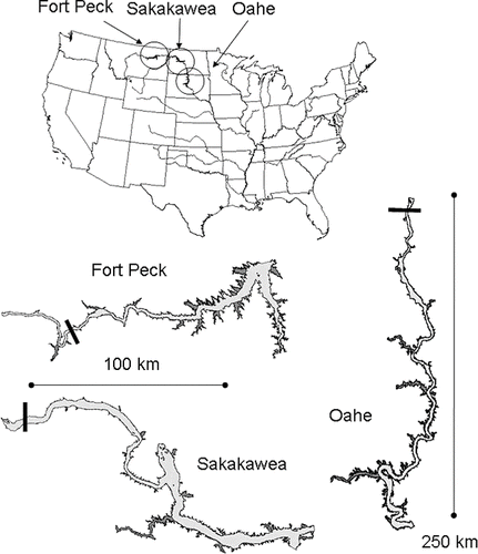
Table 1 Description of Oahe, Sakakawea, and Fort Peck from this study1 and CitationBenson (1988) 2.
Conditions were characterized for each reservoir and separately for open-water areas, bays, and nominal riverine, transitional, and lacustrine zones (CitationKimmel et al. 1990) of each reservoir. The design systematically adjusted selection probabilities to force about two-thirds of the sites into bays. Otherwise, the conditions in bays might be under-represented because they comprise relatively small proportions of reservoir area. Bays were defined as indentations of the shoreline with areas greater than that of a semi-circle with a diameter equal to the length of a line drawn across the mouth of the indentation. Bays had to be ⩾50 ha and extend ⩾1 km landward from their mouth to be included. Bays could open to the main body of the reservoir or to a larger bay. Smaller shoreline indentations were considered part of the open-water areas (). More than half of all bays were <15 km2; 70 bays were delineated in Oahe, 26 in Sakakawea, and 30 in Fort Peck (). Because the reservoirs have similar morphologies, differences in their shoreline lengths reflect the sizes and densities of bays ().
Table 2 Area-weighted mean (and standard error) of water quality variables for the whole-reservoir, open-water areas, and bays in the first sampling years: Oahe (2001), Sakakawea (2002), and Fort Peck (2003).
Boundaries between reservoir zones were determined from depth and distance from dam. In general, riverine zones included an area 0–60 km downstream from the reservoirs' headwaters. Lacustrine zones included the area within about 30 km of the dams. The size of the transitional zones varied. Data from bays and open-water areas within a zone were combined to calculate its condition.
Valid sampling sites were >0.5 m deep and <100 m from the target coordinates provided by the survey design. Some offset from the intended sampling location was accepted to compensate for Global Positioning System (GPS) errors, boat drift and draft, and to avoid hazards (e.g., wading cattle, snags). In general, samples were collected <20 m from the target coordinates. Sites that were inaccessible because of shallow water or obstructions were usually much more than 100 m from the closest approachable point. Low water levels () resulted in a failure to reach about 22% of intended sites across all reservoirs and years. Inaccessible sites were replaced with randomly selected sites to preserve expected sample sizes.
Figure 2 Average monthly reservoir water elevations (feett above mean sea level). Circles indicate sampling periods (July–August).
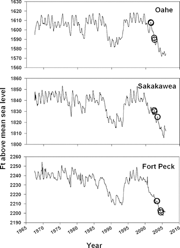
Reservoirs were sampled in July and August in each of two successive years (). There were approximately twice as many sites sampled in the first year as in the second year (; only selected first year data shown). Sampling typically was completed in 5–10 days. Water chemistry samples were collected as depth-integrated composites of equal volume subsamples from 1 m off the bottom, mid-depth, and 0.5 m from the surface. At shallow sites (<2 m), the entire sample was collected at 0.5 m from the surface. Filtrate passing a membrane filter was used for analysis of dissolved nutrients and ions. Material retained on GF/C filters was analyzed for chlorophyll using a fluorometer (). Material retained on GF/F filters was analyzed for total and volatile suspended solids (TSS and VSS, respectively). Depth profiles of DO, temperature, pH, specific conductivity, light intensity, and turbidity were measured at each site using a SeaBird™ Model 25 sensor array.
Table 3 Summary of water chemistry and sediment analytical methods.
Overviews of probability surveys, including routines for calculating statistics and adjusting site weights (or area each site represented), were from CitationOlsen et al. (1999) and at http://epa.gov/nheerl/arm. The sum of the site weights equaled the area of the reservoir. The proportions (or area) of reservoir over the observed range of parameter values were presented as cumulative distribution functions (CDF).
Results
Water quality
Water quality results for reservoirs, open-waters areas, and bays for the first sampling years are reported (). Although not all data were used in subsequent analyses, they contribute to the sparsely published water quality data for these reservoirs. Means are area-weighted, unless otherwise noted. Changes in reservoirs' water elevations () between sampling years resulted in −38%, −5%, and −25% changes in the mean depth in Oahe, Sakakawea, and Fort Peck, respectively. Changes in mean depths in bays between the sampling years were all large and negative, −78%, −26%, and −14% for Oahe, Sakakawea, and Fort Peck, respectively. Because the probability design randomly distributed sites throughout the reservoirs, mean depth estimates compensate for bathymetric differences between zones, and open-water areas and bays.
Specific conductivity and concentrations of sulfate and calcium in a reservoir were relatively stable between years (data not shown). Levels in bays were typically higher than in open-water areas (), although differences in Fort Peck were less pronounced than in the other reservoirs. Specific conductivity and sulfate continuously decreased moving upriver within reservoirs (lacustrine to riverine) and between reservoirs (). Mean conductivity decreased from 724 μS/cm in Oahe to 573 μS/cm in Sakakawea to 535 μS/cm in Fort Peck. Calcium concentrations also decreased through Oahe and Sakakawea but were relatively high and stable in Fort Peck (). Concentrations of other ions (such as Cl, K, Mg, Na, and NH4, some data not shown) did not show consistent spatial distributions within or between reservoirs.
Figure 3 Area-weighted mean (± standard error) specific conductivity (μS/cm) approximately 2 m from the bottom, and water column SO= 4 (μg/L), Ca (μg/L), SiO2 (μg/L), NO3+NO2 (μg N/L), and total N (μg N/L) in riverine, transitional, and lacustrine zones of each reservoir. First year data are shown.
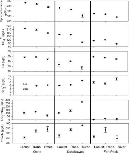
Total and dissolved water quality constituents varied widely between reservoirs and years and within reservoirs. Silica concentrations increased moving upriver within and between reservoirs (). Concentrations of NOx (NO3+ NO2) varied inconsistently between zones. Mean concentrations were almost 10 times higher in Oahe and Sakakawea than in Fort Peck (). Mean total N concentrations in riverine zones were similar (270 μg/L) and typically increased moving upriver (325–375 μg/L), except for the riverine zone of Fort Peck (). A significant increase in total N concentrations in the second sampling year in Sakakawea (coincident with decreased NOx concentrations) resulted in a substantial increase in the ratio of TN:TP, from 40 to 252 in Sakakawea (). Although Oahe and Fort Peck showed much less variability, mean TN:TP ratios were always >33, the conventional threshold for P limitation (CitationGuildford and Hecky 2000).
Figure 4 Area-weighted mean (±95% confidence bounds) concentrations of the atomic ratio of N:P, total suspended solids (TSS; mg/L), total organic carbon (μg/L), and, chlorophyll a (μg/L), Secchi depth (m), and total P (μg/L) in each reservoir. Filled circles are 2001, 2002, and 2003 for Oahe, Sakakawea, and Fort Peck, respectively. Open circles are 2002, 2003, and 2004 for Oahe, Sakakawea, and Fort Peck, respectively.
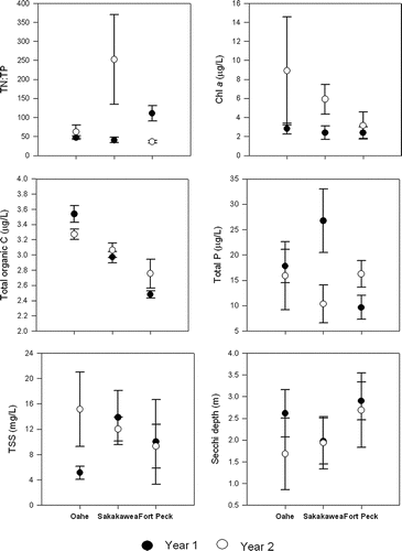
Concentrations of particulate matter (as total organic carbon [TOC], TSS, and chlorophyll), and to a lesser extent, total P, were generally similar between years within reservoirs and decreased moving upriver (). These trends are complemented by an inverse trend in Secchi depth. In 2001, the relatively low mean concentrations of TSS and chlorophyll in Oahe were accompanied by a relatively high mean Secchi depth. Chlorophyll concentrations in all reservoirs were relatively low (<4 μg/L) and similar in the first sampling years. Concentrations in Oahe and Sakakawea significantly increased in the second sampling year (). Fort Peck was the least turbid reservoir with the highest mean Secchi depth () and lowest mean light extinction coefficient.
Trophic status
Reservoir- and zone-specific trophic status indices were calculated for chlorophyll (TSIchl), Secchi depth (TSISD), and total P (TSITP). Although bays were shallower and seemingly hydrologically isolated from the open-water areas, mean TSI values were similar (). Changes in whole-reservoir means of chl, SD, and TP (, 6 and 7, heavy lines) were reflected in the proportional distribution of TSI values (, 6, and 7, light lines) across reservoir area. On average, TSIchl and TSISD indicated that Oahe was more eutrophic in 2002 than 2001 (). The proportion of Oahe considered eutrophic (TSIchl> 50; CitationUSEPA 1998) increased from about 10% to almost 40%. There was no change in mean TP concentration or TSITP distribution between years. Similar conditions were observed in Sakakawea (). Except, the decrease in mean total P concentrations in Sakakawea (from 26.74 μg/L to 10.34 μg/L) between sampling years resulted in a decrease in area of the reservoir considered eutrophic (TSI > 50) from about 35% to <5% and a decrease in mean TSITP from 48 to 31. Inter-annual differences in TSIchl and TSISD were smallest in Fort Peck (). A significant area of the reservoir became more eutrophic according to TSIchl, shifting the mean from 32 to 43. The increase in total P concentration decreased the area of Fort Peck considered oligotrophic (TSI < 30) from 50% to about 0%.
Figure 5 Cumulative distribution functions of the percentage (%) and area (km2) of Lake Oahe with increasing chlorophyll, Secchi depth, and total P (bold lines and top X axis of each panel) and TSI for chlorophyll, Secchi depth, and total P (thin lines and bottom X axis of figure). Data from the first and second sampling years are denoted by solid and dotted lines, respectively.
Figure 6 Cumulative distribution functions of the percentage (%) and area (km2) of Lake Sakakawea with increasing chlorophyll, Secchi depth, and total P (bold lines and top X axis of each panel) and TSI for chlorophyll, Secchi depth, and total P (thin lines and bottom X axis of figure). Data from the first and second sampling years are denoted by solid and dotted lines, respectively.
Figure 7 Cumulative distribution functions of the percentage (%) and area (km2) of Fort Peck Lake with increasing chlorophyll, Secchi depth, and total P (bold lines and top X axis of each panel) and TSI for chlorophyll, Secchi depth, and total P (thin lines and bottom X axis of figure). Data from the first and second sampling years are denoted by solid and dotted lines, respectively.
Within reservoirs, trophic status increased moving upstream regardless of the parameter used (). Lacustrine and transitional zone TSIs typically were more similar to each other than with TSI in riverine zones. Secchi depth TSI was the most variable, particularly in riverine zones. This reflects the shallow and turbid conditions often encountered in these areas.
Figure 8 Area-weighted mean (± standard error) of TSI for chlorophyll, Secchi depth, and total phosphorus in riverine, transitional, and lacustrine zones of each reservoir. First year data are shown.
Cold-water habitat
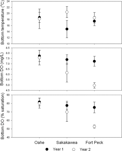
The deepest stations in each reservoir (typically in the lacustrine zones) were thermally stratified in July and August. At sites >3 m deep, only 8% had DO concentrations <5 mg/L and bottom temperatures >15°C indicating unsuitable cold water fish habitat. Most of those sites were in Fort Peck in 2004. Oahe, the deepest reservoir, experienced little change in whole-reservoir mean bottom temperature, bottom DO concentrations or % DO saturation between years (). Bottom waters in Lake Sakakawea became significantly warmer, and DO concentrations decreased between sampling years. Mean temperatures at the bottom of Fort Peck did not change between years but DO concentrations significantly decreased.
Figure 9 Area-weighted mean (± standard error) temperatures (°C), dissolved oxygen (DO) concentrations (mg/L), and % DO saturation sampled approximately 2 m from the bottom in each reservoir in each year. Filled circles are 2001, 2002, and 2003 for Oahe, Sakakawea, and Fort Peck, respectively. Open circles are 2002, 2003, and 2004 for Oahe, Sakakawea, and Fort Peck, respectively.
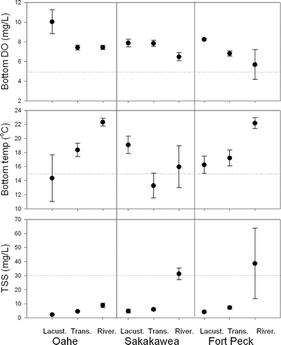
Quantifying the area-weighted proportion of the reservoirs with bottom DO concentration >5 mg/L found that, across both years, more than 90% of Oahe was potential cold water habitat, while the area of potential cold water habitat decreased in Sakakawea from 100% to 76%, and in Fort Peck from 91% to 34% (). Mean bottom DO concentrations in all zones exceeded the 5 mg/L cold water habitat criteria (). Except in Sakakawea, bottom temperatures increased from lactustrine to riverine zones. Mean bottom temperatures in most of Sakakawea and throughout Fort Peck were >15°C. Mean TSS concentrations exceeded 30 mg/L only in the riverine zones of Sakakawea and Fort Peck.
Figure 10 Cumulative distribution functions of the proportion and area (±95% confidence bounds) of each reservoir with increasing near-bottom DO concentrations (mg/L).
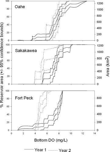
Figure 11 Area-weighted mean (± standard error) DO (mg/L), temperature (°C) at approximately 2 m from the bottom and water column total suspended solids (TSS; mg/L) in riverine, transitional, and lacustrine zones of each reservoir. First year data are shown. Nominal criteria for cold-water habitat (5 mg/L DO, 15°C, and 30 mg/L total suspended solids) are shown as horizontal lines.
Discussion
As impoundments of the Missouri River, the three reservoirs share physical and chemical characteristics that contribute to their water quality, trophic status, and potential to maintain cold water habitat. Many characteristics are common to other large temperate reservoirs (CitationKimmel et al. 1990, CitationDycus 1998, CitationFairchild et al. 2004). In particular, trophic status significantly decreased along the longitudinal gradient from riverine to lacustrine (); however, the range of TSI values between the reservoirs was relatively small. The TSI triad (TSIchl, TSISD, and TSITP) can be used to disentangle the contributions of nutrients and particulate matter in controlling phytoplankton production (CitationCarlson and Havens 2005). For example, if the three indices are approximately equal, then phytoplankton production is generally considered to be P limited and light attenuation dominated by algae. Results show that at the scale of whole-reservoirs, TSIchl was always less than TSISD, suggesting that silt, not algae, dominated light attenuation. While not reminiscent of conditions in the historical (or even contemporary) Missouri River main-stem, silt is still an important driver of trophic status in the system. Within the reservoirs, TSI of all types decreased along physico-chemical gradients as conditions changed from riverine to lacustrine. Riverine zones typically had higher inorganic TSS and chlorophyll concentrations and lower conductivity than in the lacustrine zones. Those conditions reflect the relatively high inputs of allochthonous nutrients and silt. Results from nutrient utilization and particle settling decrease downstream.
Differences between whole-reservoir mean TSIchl and TSITP were negative in one year and positive in the other year. This could reflect the response of algal production to fluctuations in the degree of P limitation. Summer P limitation is common in Missouri River reservoirs (CitationMartin and Novotny 1975). The TN:TP ratio () showed that the reservoirs were consistently P limited with values exceeding the nominal threshold of 33:1. In Lake Sakakawea, the simultaneous increase in TN concentration and decrease in TP concentration resulted in a mean TN:TP value of 252 (). Nitrogen from agricultural runoff seemed an unlikely explanation because both mean NH4 and NOx concentrations decreased between sampling years. Water column mixing, indicated by relatively high bottom temperatures (), possibly kept nutrients available for phytoplankton production and hence increased total N as algal biomass. The results of this sustained growth were evident by the near doubling of whole-reservoir chlorophyll concentrations. Soluble P concentrations were not measured but were assumed to be very low. Nominal N limitation (TN:TP < 20) was indicated for <9% of reservoirs' areas. Few differences in TN:TP ratios were apparent between bays and open-water areas ().
Results showed both interannual changes and spatial gradients of P limitations of algal growth. Such changes may be important for reservoir management because water retention time can drive relative nutrient availability and, therefore, algal assemblages. Such relationships were described from the long-term monitoring data of Kentucky Lake by CitationYurista et al. (2004). They attributed the predictable spring-to-summer decrease in N:P ratio to discharge-nutrient concentration relationships, biological uptake, and nutrient recycling. We suggest that reservoir managers capitalize on the synergy between process models and probability surveys to assess ecological conditions as responses to management actions.
Management and environmental objectives in reservoirs are inherently linked to water level. Water withdrawal, in particular hypolimnetic withdrawal, can negatively impact water quality and habitat conditions supporting fisheries and recreation. In this study, water elevations decreased approximately 5.5 m, 1.8 m, and 3.1 m in Oahe, Sakakawea, and Fort Peck, respectively () between the sampling years. These changes resulted in a 38% decrease in mean depth of Oahe and a 78% decrease of depth in its bays. Our data represent all areas of the reservoirs and therefore account for bathymetric variability. The dewatering of bays is particularly important because it reduces the availability of nursery and spawning areas for fish and birds. In some cases, tributaries become isolated from the reservoirs behind sediment dams and bars. Low water also can expand littoral vegetation. Vegetation beds and stable substrates can temporarily immobilize contaminants, which can then re-enter reservoir food webs with rising water levels (Mike Ell, North Dakota Department of Health, 2005, pers. comm.). Pulses of contaminants and limited habitat can stress reservoir biota.
Maintaining clear, cold, and well-oxygenated bottom waters is a management priority of the Missouri River reservoirs. Reservoir morphology can be a key factor in preserving cold water habitat as water levels decrease. Drought, wind, and hypolimnetic withdrawals can shrink cold water habitats by deepening the thermocline or preventing thermal stratification. Sustained drought can substantially decrease the availability of cold water habitat in these reservoirs (CitationElstad 2001). In this study, mean bottom temperatures and DO concentrations, except for Fort Peck (in 2004), were close to or exceeded nominal cold water habitat criteria. Each reservoir supported some cold water habitat in the summer.
Conclusions and recommendations
We conclude that probability surveys of selected water quality parameters can be used to characterize important environmental conditions in large reservoirs at scales and with statistical powers unobtainable with other sampling approaches or models. We recommend that reservoir monitoring programs consider using surveys to assess and monitor water quality, trophic conditions, and the availability and quality of fish habitat. We do not suggest that surveys are the only or best approach for all reservoir or lake monitoring, assessment, or management needs. Site-specific approaches (e.g., CitationDycus 1998, CitationFairchild et al. 2004) and models remain critical tools for addressing local water quality problems or environmental processes; however, generalizing site-specific data to unsampled areas or considering them representative of a larger region may be statistically risky. This contrasts with probability surveys that yield statistically unbiased estimates of the full range of conditions at explicit spatial or temporal scales using a relatively small number of sites. Incorporating spatial sub-units (e.g., bays/open-water areas, riverine/lacustrine zones) can further increase the analytical power. As shown here, post hoc analyses are informative but can suffer from limited sample sizes. Using probability surveys to quantify the extent of important reservoir characteristics, such as trophic status or cold water fish habitat, provides managers with valuable baseline information to compare management outcomes or expectations.
Acknowledgemnts
The authors thank Leroy Anderson, Anne Cotter, and Greg Peterson for the chemical analyses. Peder Yurista, Sharon Batterman, Terri Jicha, and David White provided comments on the manuscript.
The information in this document has been funded wholly by the U.S. Environmental Protection Agency. It has been subjected to review by the National Health and Environmental Effects Research Laboratory and approved for publication. Approval does not signify that the content reflects the views of the Agency, nor does mention of trade names or commercial products constitute endorsement or recommendation for use.
References
- Benson , N. G. 1988 . The Missouri River: the resources, their uses and values , Special Publication 8, North Central Division of the American Fisheries Society .
- Bryan , S. D. , Hill , T. D. , Lynott , S. T. and Duffy , W. G. 1995 . The influence of changing water levels and temperature on the food habits of fish in Lake Oahe, South Dakota . J. Freshw. Ecol. , 10 : 1 – 10 .
- Carlson , R. E. 1977 . A trophic state index for lakes . Limnol. Oceanogr. , 22 : 361 – 369 .
- Carlson , R. E. and Havens , K. E. 2005 . Simple graphical methods for the interpretation of relationships between trophic state variables . Lake Reserv. Manage. , 21 : 107 – 118 .
- Dycus , D. L. 1998 . Indicators of reservoir ecological condition http://acwi.gov/monitoring/conference/98proceedings/Papers/45-DYCU.html Accessed 1 April 2009
- Elstad , S. 2001 . Chemical and physical properties of Lake Sakakawea 1992-2000 , North Dakota Department of Health Division of Water Quality surface Water Program .
- Fairchild , J. , Lakish , B. , Echols , K. , Chapman , D. , Johnson , T. and Jones , S. 2004 . An integrated assessment of the trophic status of Fort Cobb reservoir, Oklahoma , Billings , MT : USGS Columbia Environmental Research Center . Final Report to Great Plains Region, U.S. Bureau of Reclamation http://www.cerc.usgs.gov/pubs/center/pdfDocs/Fort_Cobb.pdf Accessed 1 April 2009
- Guildford , S. J. and Hecky , R. E. 2000 . Total nitrogen and total phosphorus nutrient limitation in lakes and oceans: is there a common relationship? Limnol . Oceanogr. , 45 : 1213 – 1223 .
- Goransson , E. , Johnson , R. K. and Wilander , A. 2004 . Representativity of a mid-lake surface water chemistry sample . Environ. Monit. Assess. , 95 : 221 – 238 .
- Kennedy , R. H. and Walker , W. W. 1990 . “ Reservoir nutrient dynamics ” . In Reservoir limnology: ecological perspectives , Edited by: Thornton , K. W. , Kimmel , B. L. and Payne , F. E. 109 – 132 . New York , NY : Wiley Interscience .
- Kimmel , B. L. , Lind , O. T. and Paulson , L. J. 1990 . “ Reservoir Primary Production ” . In Reservoir limnology: ecological perspectives , Edited by: Thornton , K. W. , Kimmel , B. L. and Payne , F. E. 133 – 194 . New York , NY : Wiley Interscience .
- Lind , O. T. 2002 . Reservoir zones: microbial production and trophic state . Lake Reserv. Manage. , 18 : 129 – 137 .
- Martin , D. B. and Novotny , J. F. 1975 . Nutrient limitation of summer phytoplankton growth in two Missouri River reservoirs . Ecology , 56 : 199 – 205 .
- McDonald , M. , Blair , R. , Bolgrien , D. , Brown , B. , Dlugosz , J. , Hale , S. , Hedtke , S. , Heggem , D. , Jackson , L. , Jones , K. , Levinson , B. , Linthurst , R. , Messer , J. , Olsen , A. , Paul , J. , Paulsen , S. , Stoddard , J. , Summers , K. and Veith , G. 2004 . Environmental Protection Agency, Environmental Monitoring and Assessment Program , Edited by: Wiersma , G. B. 649 – 668 . Environmental Monitoring, CRC Press .
- National Research Council . 2002 . “ The Missouri River Ecosystem: Exploring the prospects for recovery ” . In Water Science and Technology Board , 175 National Academy Press .
- Olsen , A. R. , Sedransk , J. , Edwards , D. , Gotway , C. A. , Liggett , W. , Rathbun , S. , Reckhow , K. H. and Young , L. J. 1999 . Statistical issues for monitoring ecological and natural resources in the United States . Environ. Monit. Assess. , 54 : 1 – 45 .
- Schweiger , E. W. , Bolgrien , D. W. , Angradi , T. R. and Kelly , J. R. 2005 . Environmental monitoring and assessment of a Great River ecosystem: The Upper Missouri River Pilot . Environ. Monit. Assess. , 103 : 21 – 40 .
- USEPA . 1998 . Lake and reservoir bioassessment and biocriteria technical guidance document , Washington , D.C. : U.S. Environmental Protection Agency . 841-B-98-007
- Yurista , P. M. , White , D. S. , Kipphut , G. W. , Johnston , K. , Rice , G. and Hendricks , S. P. 2004 . Nutrient patterns in a mainstem reservoir, Kentucky Lake, USA, over a 10-year period . Lake Reserv. Manage. , 20 ( 2 ) : 148 – 163 .