Abstract
Lake Mead was formed in the 1930s by the construction of Hoover Dam on the Colorado River. Hoover Dam was one of the first multipurpose dams constructed by the federal government. Lake Mead is the largest reservoir in the United States by volume (3.5479 × 10¹⁰ m3 at full pool) and is second only to Lake Powell in surface area (637.05 km2). Water from Lake Mead is used for municipal and industrial purposes and irrigation water by approximately 25,000,000 people. The Colorado River provides approximately 97% of the inflow, with the remainder coming primarily from Las Vegas Wash and the Virgin and Muddy rivers. Flow in Las Vegas Wash more than doubled over the past 30 years as a result of the rapid population growth in Las Vegas. Lake surface elevations have dropped by about 40 m since 1999 as a result of extended drought and increasing water demands brought about by population growth. This elevation change impacted water quality and recreation and is just one of many management challenges facing the lake. The discovery of adult quagga mussels (Dreissena rostriformis bugensis) in Lake Mead in February 2007 created infrastructure management problems and raised concerns about lake biology and water quality. The impacts of this invasion are still under investigation. This manuscript provides information on the history of Lake Mead, as well as descriptions of lake and watershed characteristics, hydrology, water quality, fisheries, and recreation that lake managers can use to guide future assessment and management of Lake Mead.
Background and history
Lake Mead is a large reservoir on the mainstem of the Colorado River. Hoover Dam, which formed Lake Mead, is located in Black Canyon approximately 50 km (30 mi) east of Las Vegas, Nevada, in the Mojave Desert, Arizona-Nevada (). At full pool, Lake Mead is the largest reservoir in the United States by volume (3.5479 × 10¹⁰ m3) and is second only to Lake Powell in surface area (637.05 km2; Paulson and Baker 1983). Lake Mead has enough capacity to hold the entire average annual flow of the Colorado River for 2 years (WPRS 1981).
Figure 1 Key features of Lake Mead.
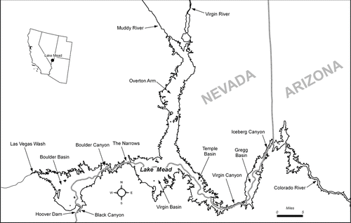
At full pool, Lake Mead extends 105 km (65 mi) from Hoover Dam to Pearce Ferry. Its greatest width is 15 km (9.3 mi), and the highly irregular shoreline is 885 km (550 mi) in length (WPRS 1981). Lake Mead includes 4 large, deep, but connected basins that cover deep canyons and their steep walls along the historic Colorado River channel. From upstream to downstream, these basins are Gregg, Temple, Virgin and Boulder. The 4 basins are ecologically distinct from one another because the waters within them retain the properties of their sources (CitationLaBounty and Burns 2005). Four narrow canyons (Iceberg, Virgin, Boulder and Black) and the 53 km (32.9 mi) long Overton Arm, which extends south from the Virgin and Muddy rivers to the Virgin Basin, are other important features of the lake ().
The construction of Hoover Dam was authorized by the Boulder Canyon Project Act in 1928 (CitationBillington et al. 2005). The site for the dam was initially proposed to be within The Narrows at the upper end of Boulder Canyon (), but it was recognized early in the planning process that a site in Black Canyon would be less costly, had a better geological setting and would also lead to additional water storage and hydropower generation. Construction of Hoover Dam started in 1931, and the dam started impounding water on 1 February 1935 (R. Walsh, US Bureau of Reclamation, Nov 2010, pers. comm.) Final construction work on the dam was completed in 1936 (CitationLara and Sanders 1970).
Hoover Dam was one of the first multipurpose dams built by the federal government. Its primary intended uses were flood control, navigation and generation of electrical energy. Other uses were facilitation of agricultural development in the Colorado Basin and Imperial Valley and municipal growth in Los Angeles (CitationBillington et al. 2005). Hydropower generation was a key factor in financing the Boulder Canyon Project. The planned generating capacity of more than 1,000,000 horsepower represented more than 20% of the power generation capacity in the western states at the time of its construction. The first commercial power was generated at Hoover Dam on 7 October 1936, and continuous, commercial power generation began in June 1937 (CitationBillington et al. 2005). The current rated capacity of the Hoover Dam powerplant is 2,998,000 horsepower (USDOI Frequently Asked Questions and Answers, 9 Dec 2010). Income from power generation paid for construction of the dam and continues to pay for the operation, maintenance and replacement work at the dam.
Lake Mead currently provides municipal water for the cities of Las Vegas, Henderson, North Las Vegas and Boulder City, Nevada, as well as municipal and industrial water and irrigation water for downstream users. Altogether, about 25,000,000 people rely on water from Lake Mead. It is unlikely that the southwest could have developed as it has without the water provided by Lake Mead.
The Bureau of Reclamation (Reclamation) manages water and power deliveries, which includes control of lake discharge and operation and maintenance of Hoover Dam and the powerplant. The National Park Service (NPS) administers recreational activities in the Lake Mead National Recreation Area (LMNRA), which includes Lakes Mead and Mohave and surrounding areas.
Lake characteristics
There is considerable confusion concerning some key morphometric and hydrologic characteristics of Lake Mead. Project data reported by the Bureau of Reclamation (WPRS 1981) include volumes and surface areas for water surface elevations of 375.5 m (1232 ft, crest of dam), 374.6 m (1229 ft, top of flood control) and 372.3 m (1221.4 ft, top of spillway gates). Lake surface areas, volumes and maximum depths have been reported based on the original construction survey in 1935 before the dam was completed, a survey undertaken in 1948–1949 to determine volume losses by sedimentation (USDOI 1954, USGS 1960) and a 1963–1964 survey to update the capacity of the reservoir at the time of the closure of Glen Canyon Dam in March 1963 (CitationLara and Sanders 1970). Lake Mead was surveyed again from 1999 to 2001 by the United States Geological Survey (USGS) and Reclamation; results from those surveys were reported by Twichell et al. (2003) and CitationFerrari (2008). Data from the 1999–2001 surveys are still undergoing verification, quality checking and quality assurance and will not replace data from the CitationLara and Sanders (1970) survey for operational purposes until that process is completed.
Key characteristics of Lake Mead () are based on data from CitationFerrari (2008) at the surface elevation of 372.3 m (1221.4 ft). The mean inflow used was that reported by CitationFerrari (2008) for the period 1935–2001.
Table 1 Morphometric and hydrologic characteristics of Lake Mead.
Sediment accumulation has been significant. CitationLara and Sanders (1970) reported that 1.7588 × 10⁹ m3 (1,425,900 ac-ft) of sediment accumulated in Lake Mead between 1935 and 1948–1949. An additional 1.5950 × 10⁹ m3 (1,293,100 ac-ft) accumulated between 1948–1949 and 1963–1964 to total 3.3512 × 10⁹ m3 (2,716,900 ac-ft), or approximately 12% of the original lake volume. The completion of Glen Canyon Dam greatly slowed the amount of sediment transport to Lake Mead and was estimated to increase the life of Lake Mead by 500 years (CitationLara and Sanders 1970). The Ferrari (2008) survey confirmed the interception of most sediments by Lake Powell and found the volume of Lake Mead actually increased by 2.7032 × 10⁸ m3 (219,150 ac-ft) between 1963–1964 and 2001. The increase was attributed to the reduction in sediment inflow and the consolidation of previous sediment deposits.
Lake Mead watershed
The Lake Mead watershed includes parts of 6 states: Colorado, Wyoming, New Mexico, Utah, Nevada and Arizona. Characteristics of the 4 main inflows to Lake Mead, the Colorado, Virgin and Muddy rivers and Las Vegas Wash, and their watersheds are described on the USGS National Water Information System web site (http://waterdata.usgs.gov/nwis).
The Colorado River watershed above Lake Mead has a total area of 386,727 km2 (149,316 mi2), but 10,250 km2 (3959 mi2) in the Great Divide basin in Wyoming and 1810 km2 (697 mi2) on the Colorado Plateau do not contribute runoff to Lake Mead. Noncontributing areas are found in many western watersheds and are typically closed basins with no streams connecting to downstream discharges. Most of the land in the Colorado River watershed is either rangeland or forest. The availability of water within the Colorado River system depends primarily on the amount of annual snowmelt and rainfall received on the western slope of the Rocky Mountains in Colorado, which is the source of the Colorado River. A smaller percentage of water comes from tributaries and washes along the river.
The Overton Arm collects the combined drainages of the Virgin and Muddy rivers. These watersheds have a combined area of more than 31,160 km2 (12,030 mi2), but more than half, 9790 km2 (3780 mi2) of the 17,970 km2 (6940 mi2) in the White and Meadow Valley Wash sub-basins of the Muddy River watershed, does not contribute runoff to Lake Mead. The Virgin and Muddy river watersheds are also mostly either rangeland or forest at the present time, but the cities of St. George, Utah, and Mesquite, Arizona, are undergoing rapid development that may affect both water quality in Lake Mead and the quantity of water delivered to the lake in the future.
Drainage entering Lake Mead through Las Vegas Wash includes both nonpoint surface and groundwater discharges, runoff from the Las Vegas metropolitan area and treated effluent from the City of Las Vegas, City of Henderson and Clark County municipal wastewater treatment facilities. The tributary flows to Las Vegas Wash are discussed in detail elsewhere in this volume (CitationRyan and Zhou 2010). The total drainage area for the Las Vegas Wash watershed is 5680 km2 (2193 mi2), but 1570 km2 (607 mi2) of that area does not contribute surface runoff to Lake Mead. The Las Vegas Wash watershed is also predominantly rangeland, but the rapidly expanding urban area of Las Vegas covered approximately 427 km2 (165 mi2) as of the year 2000 (CitationHoldren et al. 2006).
Hydrology
Lake Mead is fed by the Colorado River and 3 smaller tributaries: the Virgin and Muddy rivers and Las Vegas Wash. Gregg Basin and Temple Basin are fed by the mainstream of the Colorado River, which now enters Lake Mead at the northern end of the Gregg Basin, nearly 97 km (60 mi) upstream of Hoover Dam. Virgin and Muddy rivers flow into the Overton Arm, and then travel 40 km (25 mi) under current conditions to merge with Colorado River water in the Virgin Basin. The combined flows from the upper end of the lake enter the east end of Boulder Basin at the Narrows. Las Vegas Wash enters Las Vegas Bay at the west end of Boulder Basin. Runoff into Lake Mead can be estimated from USGS gauging stations on these tributaries (), but several factors affect the accuracy of those measurements. Surface runoff from the Lake Mead watershed was estimated from USGS water resources data for each of the 4 major tributaries to Lake Mead. Beginning with water year 2004, runoff data for these sites are only available from the USGS, National Water Information System (accessed 9 Dec 2010). Information from all gaging stations used to evaluate runoff was summarized ().
Table 2 USGS gaging stations above Lake Mead.
Station 09404200, Colorado River above Diamond Creek near Peach Springs, Arizona, is located near the lower end of the Grand Canyon 210 km (130 mi) upstream from Hoover Dam; both water gains and water losses are expected as the Colorado River flows through the Grand Canyon, but no significant tributaries enter the Colorado River below Diamond Creek so this station should still provide a reasonably good estimate of inflow to Lake Mead. Available and estimated flow data since July 2002, when the Las Vegas Wash station resumed operation, indicate the Colorado River is currently contributing about 96.9% of the flow to Lake Mead.
The Virgin River at Littlefield (09415000) and Muddy River near Glendale (09419000) stations have historically been used to describe inflows to Lake Mead because of their long periods of record. Station 09415000 is located 58 km (36 mi) upstream of Lake Mead and Station 09419000 is located 26 km (16 mi) upstream of the lake. Both stations significantly overestimate inflow to Lake Mead because agricultural operations between the gauges and the lake divert almost the entire flow of both rivers during the summer months. As a result, many previous reports attribute too much flow to these 2 tributaries.
Two lower stations, 09415250, Virgin River above Lake Mead near Overton, Nevada, and 09419507, Muddy River at Lewis Avenue at Overton were installed more recently and are located 6.8 and 9.25 km (4.2 and 5.75 mi), respectively, upstream of Lake Mead to give a much better indication of actual inflows. These stations have only operated for short periods and records are not continuous, but flow data clearly show the impacts of the diversions. Flows at the downstream Overton station on the Virgin River averaged 67% of the upstream Littlefield site (range = 0–129%) and the downstream Lewis Avenue site on the Muddy River averaged 40% of the upstream Glendale site (range = 17–53%). Due to falling water levels, the Virgin and Muddy rivers have been entering Lake Mead as a combined inflow since July 2009.
The errors in measurement for the Virgin and Muddy river flows overestimated inflows from these tributaries in previous studies but have relatively little impact on the overall water budget for Lake Mead. Based on estimated inflows using the lower gauges, the Virgin and Muddy rivers currently contribute 0.8% and 0.1%, respectively, of the total inflow to Lake Mead.
The annual inflow via Las Vegas Wash has increased dramatically over the past 30 years as a result of the rapid population growth in Las Vegas. Flows from Las Vegas Wash into Lake Mead averaged more than 8.13 m3/sec (287 cfs), or 2.2% of the total inflow, since 2002. This is more than double the average of 3.06 m3/sec (108 cfs) measured at this station in the 1980s.
Direct precipitation on the lake surface was calculated using data from the Western Regional Climate Center (Western Regional Climate Center Average, accessed 9 Dec 2010). Average precipitation from the period of record from 5 weather stations around Lake Mead (Callville Bay, NV, Station 261371; Echo Bay, NV, Station 262497; Valley of Fire State Park, NV, Station 268588; Temple Bar, AZ, Station 028516; Willow Beach, AZ, Station 029376) was 0.146 m/yr (5.74 in/yr). At the full pool surface area of 6.37 × 10⁸ m2, direct precipitation would contribute 9.29 × 10⁷ m3/yr (75,300 ac-ft/yr), <1% of the total tributary inflow but slightly more than inflow from the Virgin and Muddy rivers.
Discharges through Hoover Dam are variable. Water is released as needed to meet water deliveries to Arizona, California, Nevada and Mexico as stipulated by the Colorado River Compact. Most of Nevada's share of Colorado River water is withdrawn directly from Lake Mead to meet requirements for the Las Vegas Valley, but Nevada does have additional diversions downstream of Hoover Dam. Discharge from Hoover Dam occurs at elevations of 273 and 319 m (895 and 1045 ft) a.s.l. Both outlets are in the hypolimnion at full pool, but the upper outlet is near the bottom of the epilimnion at current lake levels. The annual discharge is about 9 × 10⁹ m3 (7.3 × 10⁶ ac-ft). Annual withdrawals by the Southern Nevada Water Authority (SNWA) to provide municipal water for Las Vegas are currently about 5.55 × 10⁸ m3/yr (450,000 ac-ft/yr; Roefer et al. 1996).
Evaporation in the area is extremely high and represents a significant water loss. Pan evaporation averages 2.88 m/yr (113.53 in/yr) in Boulder City, Nevada, corresponding to an evaporation rate of 2.02 m/yr (79.5 in/yr) from the lake surface (CitationFarnsworth and Thompson 1982). At full pool, evaporative losses would be 1.29 × 10⁹ m3/yr (1,043,000 ac-ft/yr), almost 10% of the average annual inflow.
In practice, the water budget for Lake Mead is highly regulated and depends primarily on releases from Lake Powell through Glen Canyon Dam and downstream releases through Hoover Dam. River operations are controlled by Reclamation to meet legal requirements and contractual demands for municipal and industrial and irrigation water. Reclamation's operations use the Riverware model to evaluate releases from Lake Powell to the Colorado River; consumption by the SNWA, downstream releases for the Central Arizona Project, Metropolitan Water District of Southern California and other Lower Basin water contractors; required deliveries under treaty with Mexico; inflows from other tributaries; bank storage; and evaporative losses to control inflows and outflows for Lake Mead.
Lake elevation
Lake surface elevation reflects the inflow–outflow regime, and large differences in elevation are primarily a reflection of drought years. Lake Mead began filling in late 1934 and the average daily surface elevations can be tracked from 1 February 1935, when elevation data began to be collected, through 2009 (). The reservoir did not reach 318.5 m (1045 ft) a.s.l., the elevation of the upper outlet, until 1 May 1937. The reservoir filled to an elevation of over 366 m (1200 ft) a.s.l. by mid-1941 and fluctuated annually between that elevation and 332 m (1090 ft) through the early 1960s.
Figure 2 Lake Mead Surface elevation, 1 February 1935 to 31 December 2009.
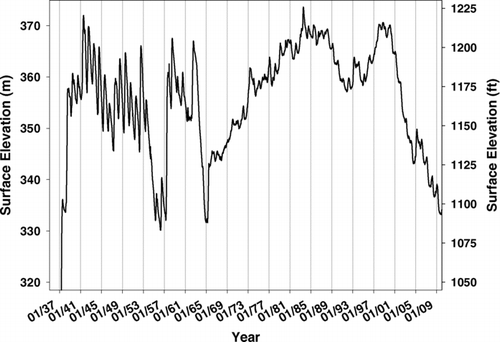
Glen Canyon Dam, which impounds Lake Powell, was completed in 1963 and Lake Powell began to fill. At the initial filling, Lake Mead elevations dropped significantly as inflows were reduced. Although Lake Mead gradually began filling again after Lake Powell reached the minimum pool required for power generation in that reservoir in 1965, full pool in Lake Mead was not reached again until 1983. Seasonal fluctuations due to variations in inflow were greatly reduced by the buffering capacity of Lake Powell ().
Lake Mead filled to capacity (elevation >372.3 m [1221.4 ft]) in July 1983, and the spillway gates operated for the first time under normal operating conditions. The maximum recorded elevation of 373.633 m (1225.83 ft) was reached on 24 July 1983.
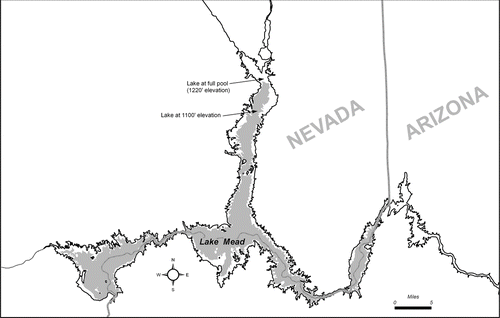
Lake Mead surface elevations dropped through the late 1980s and rose again to over 370 m (1215 ft) in 1999. Since that time, an extended drought and increasing water demands brought about by population growth in the Lake Mead watershed caused an unprecedented drop in lake levels. The impact of elevation on lake surface area () as the lake dropped from 370 m to 335 m (1100 ft), reached in 2009, was notable. The surface area and lake volume at the 335 m elevation were 363.46 km2 (89,814 ac) and 1.762 × 10¹⁰ m3 (142,844,400 ac-ft), respectively (CitationFerrari 2008). These values are 57.0% of the area and 49.7% of the volume at full pool. Note that on 27 Nov 2010 the surface elevation fell to 330.1 m (1083.1 ft).
Figure 3 Lake Mead at full pool (outline) and at the approximate current elevation of 1100 ft (335 m, gray fill).
Water quality
Lake Mead has been widely studied, but a complete review of existing literature is beyond the scope of this manuscript. Boulder Basin is the most intensively investigated area of Lake Mead because of its proximity to the Las Vegas drinking water intakes and the discharge at Hoover Dam. Representative studies of this area include CitationBaker et al. (1977), CitationLaBounty and Horn (1997), CitationLaBounty and Burns (2005), and CitationLaBounty (2008). Paulson and Baker (1983) and CitationHoldren et al. (2006) presented results for the entire lake.
As with many reservoirs, dam operations exert a great influence on the water quality and ecology of the system (CitationThornton 1990). The hydrodynamics of such large reservoirs are complex. Each basin within Lake Mead is ecologically unique and therefore responds differently to the inflow–outflow regime. Furthermore, the different sources of water entering Lake Mead, as in other reservoirs (CitationFord 1990), often retain their identity and influence for substantial distances into the reservoir and do not always mix completely with the rest of the water column. The incomplete mixing of inflows to Lake Mead with the surrounding water can lead to erroneous conclusions regarding the conveyance and fate of materials transported into the reservoir.
Lake Mead is a deep, subtropical monomictic lake (CitationBaker et al. 1977). Stratification usually begins in May or June and turnover begins in November. Destratification is most complete in January or February, although Lake Mead does not completely destratify every year (CitationLaBounty and Burns 2005). A pronounced, negative heterograde oxygen profile develops throughout the lake with stratification, leading to oxygen depletion at the thermocline. The metalimnetic oxygen depletion is the result of community biological respiration (CitationBaker et al. 1977).
All tributaries to Lake Mead carry heavy sediment loads and are either colder (Colorado River), saltier (Las Vegas Wash), or both (Virgin and Muddy rivers) than the receiving waters of Lake Mead. As a result of their higher density relative to Lake Mead waters, the Colorado, Virgin, and Muddy rivers tend to enter Lake Mead as interflows or underflows, while Las Vegas Wash typically enters as an underflow in the winter, an interflow in the summer and fall, and as an overflow in the spring. This flow regime tends to limit mixing, and therefore nutrient availability, because the majority of nutrients in the river inflows enter either the hypolimnion or lower part of the epilimnion and are therefore unavailable to support algal growth (Paulson and Baker 1983). The impacts of the interflows in Boulder Basin were described in detail by CitationLaBounty and Horn (1997).
Average physical characteristics and nutrient concentrations measured directly in the inflows from 2001–2009 () are from continuing studies conducted by Reclamation's Technical Service Center (TSC). The studies began with Boulder Basin in mid-1990. Sites on the Overton Arm were added in 1999, and sites along the mainstem of the Colorado River in Lake Mead were added in 2001.
Table 3 Chemical and physical characteristics of Lake Mead inflows, 2001–2009.
Productivity is usually low in the upper reaches of the lake because the Colorado, Virgin, and Muddy rivers enter as underflows or interflows. On the basis of annual average total phosphorus concentrations (<0.006 mg/L), Secchi depths (>9 m), and chlorophyll a concentrations (<0.001 mg/L; TSC unpublished data), the Temple and Virgin basins, the lower half of the Overton Arm and the upper end of Boulder Basin would all be considered oligotrophic to mesotrophic according to the CitationCarlson (1977) trophic state indices and EPA criteria (USEPA 1980).
In contrast, areas near the lake inlets typically have high nutrient concentrations (), high chlorophyll a concentrations (0.002 to >0.020 mg/L) and very low Secchi depths (usually <0.2 m) and would be considered eutrophic to hypereutrophic. Note that phosphorus concentrations in Las Vegas Wash have been decreasing as a result of phosphorus removal efforts by wastewater dischargers.
Lake Mead is strongly phosphorus limited (Paulson and Baker 1983, CitationLaBounty and Burns 2005). The strongest statistical relationships with decreasing Secchi transparency are with chlorophyll a and total phosphorus concentrations (CitationLaBounty 2008).
Because of the discharge through Las Vegas Wash, a large fraction of Lake Mead's bioavailable nutrient loading is confined to the most downstream basin, Boulder Basin, and productivity is highest in that area of Lake Mead (Paulson and Baker 1983, CitationPrentki and Paulson 1983, CitationLaBounty and Horn 1997, CitationLaBounty and Burns 2005). It is unusual for a reservoir to have its highest productivity in the most downstream basin, and such a condition is opposite the more frequently observed decreasing productivity gradient from upstream to downstream (CitationKimmel et al. 1990).
Water quality characteristics measured in the Lake Mead outflow (USGS National Water Information System, accessed 9 Dec 2010) were used to approximate overall lake characteristics, although, as mentioned previously, characteristics of each individual basin are heavily influenced by their source inflows. Average values for physical characteristics, nutrients and major ions from this station from 2001 to 2009 were summarized ().
Table 4 Chemical and physical characteristics of outflow from Lake Mead, 2001–2009.
Biological resources
Native Fish
The razorback sucker (Xyrauchen texanus) is the only native fish currently found in Lake Mead. This species is 1 of 4 endemic, large-river fish species of the Colorado River Basin presently considered endangered by the US Department of the Interior (USFWS 1991). Razorback suckers were historically widespread and common throughout the larger rivers of the Colorado River Basin (CitationMinckley et al. 1991), but the distribution and abundance of this species has been greatly reduced from historic levels. These declines have been attributed to human-caused alterations in the habitat, particularly the construction of dams and the resultant cool tailwaters and reservoir habitats that replaced the relatively warm, riverine environment (CitationHolden and Stalnaker 1975, CitationJoseph et al. 1977, CitationWick et al. 1982, CitationMinckley et al. 1991) and the introduction of numerous species of non-native fish to these newly created habitats (CitationMinckley et al. 1991, CitationMarsh et al. 2003).
It is unknown why razorback suckers have been able to persist in Lake Mead for the past 75 years without population augmentation, or why they are able to continue to recruit new adults into their population when there is no evidence of this anywhere else in the Colorado River System in recent years. The working hypothesis is that recruitment occurs only in areas where high turbidity provides adequate cover for young razorbacks to escape predators. There are essentially 4 areas that stand out in terms of these unique cover aspects conducive to razorback sucker recruitment: Las Vegas Wash inflow, Muddy River/Virgin River inflow, Echo Bay and the Colorado River inflow (CitationGolden and Holden 2001, Citation2002, Citation2003). Currently, recruiting populations are known to occur at the Las Vegas Wash inflow, Echo Bay and the Muddy River/Virgin River inflow areas. CitationUmek and Chandra (2010) provide additional information on razorback suckers in Lake Mead.
Sportfish
The sport fishery in Lake Mead consists entirely of exotic game species that have been either stocked within the reservoir or have arrived from one of the tributaries. Principal game species, which have established self-sustaining populations, include striped bass (Morone saxatilis), largemouth black bass (Micropterus salmoides), smallmouth black bass (Micropterus dolomieu), black bullhead (Ameiurus melas), channel catfish (Ictalurus punctatus), crappie (Pomoxis spp.), green sunfish (Lepomis cyanellus), common carp (Cyprinus carpio), Tilapia (Tilapia spp.) and bluegill (Lepomis macrochirus). The Nevada Division of Wildlife stocks rainbow trout (Oncorhynchus mykiss) during the winter to provide a “put-and-take” sport fishery.
Two forage fish are also found in Lake Mead and are important in maintaining the sport fishery. The threadfin shad (Dorosoma petenense) was first introduced into the lake in 1955. Gizzard shad (Dorosoma cepedianum), a less desirable forage species, were first detected in Lake Mead in 2007 and have apparently become well established.
Biological threat - quagga mussels
Adult quagga mussels (Dreissena rostriformis bugensis) were found in Lake Mead in January 2007, with the initial colonization probably occurring 3–4 years earlier (CitationMoore 2010). Veligers first appeared in TSC samples in March 2007 and had spread to all sampling stations by May 2008 (CitationHoldren et al. 2010). Significant impacts on water quality, lake biology and infrastructure were expected based on experiences with zebra mussels (Dreissena polymorpha) in other parts of the country (CitationLaBounty 2008, CitationBeaver et al. 2010). To date, no significant impacts on either water quality or lake biota have been published that can be directly attributed to quagga mussels, but CitationBeaver et al. (2010), CitationMueting et al. (2010) and CitationWittmann et al. (2010) discuss various aspects of quagga mussel biology in Lake Mead in this issue of Lake and Reservoir Management.
Infrastructure impacts have been significant for both Reclamation's operations at Hoover Dam and SNWA's water intakes. Mussel colonization creates concerns for water delivery and has led to increased operational costs. Research on dealing with infrastructure impacts continues.
Recreation
The LMNRA annually receives approximately 8 million recreational visits with approximately 50% of visitors traveling from Southern California. The remaining visitors are primarily from Nevada, Arizona, Utah and other western states. Currently, there are 4 marinas in operation on Lake Mead, through concession contracts with the NPS. There are 6 boat launch ramps on Lake Mead. When all facilities are operational at high water levels, the marina capacity for Lake Mead as established by the 2005 LMNRA Lake Management Plan (NPA 2005) is 3357 slips, and an additional 460 boats are available for rent from concessions. The daily public launch capacity was set at 3000 boats, and the boating capacity for Lake Mead was set at 3295 boats on the water at any one time.
The declining lake levels observed between 2000 and 2010 affected public access to Lake Mead and created infrastructure modification and operational demands on the NPS and its concessioners. At an elevation of 329.8 m (1082 ft) in October 2010, the lake is almost 43 m (140 ft) below full pool elevation. Boat launch ramps at Pearce Ferry, Government Wash, Las Vegas Bay and Overton Beach have been closed as lake waters have receded such that those ramps no longer provide reasonable access. Low water levels forced closure of marina operations at Las Vegas Bay, Boulder Harbor and Overton Beach. All lake access points have been dramatically impacted. Concessioners are having difficulty moving the marinas and extending utilities to keep the marinas operational at current water levels, and water levels continue to drop. At each of the public launch ramps, the NPS and its concessioners continue to chase water depths compatible with boating recreation; falling lake levels adversely impact recreational lake access and, in turn, visitor use at Lake Mead.
Conclusions
Lake Mead is arguably the most important reservoir in the United States because of its size and user population. Managing this resource presents a variety of challenges because of its size and complexity. As a result of the importance of Lake Mead as a source of water, power and recreation, it is critical that those challenges be met.
Concern over the these management challenges led to the development of a long term monitoring and research plan (CitationTurner et al. 2010) for Lake Mead and Lake Mohave, which is also part of the LMNRA. The NPS is managing this activity, but many other stakeholders are contributing to the process. The management plan is being used to categorize lake resources, guide research on lake chemistry and biology, evaluate potential impacts of the quagga mussel invasion and serve as a road map for future management decisions.
Acknowledgments
Funding for this work was provided by the Southern Nevada Water Authority, the National Park Service, and the Bureau of Reclamation Lower Colorado Regional Office and Science and Technology Program. Mark Sappington, National Park Service, Lake Mead National Recreation Area, Boulder City, Nevada, prepared Figures and 3 for this document. Bruce Williams and Robert Walsh at the Reclamation Lower Colorado Regional Office and 3 anonymous reviewers suggested helpful revisions.
This article not subject to U.S. copyright law.
References
- Baker , J R , Deacon , J E , Burke , T A , Egdorf , S S , Paulson , L J and Tew , R W . 1977 . Limnological Aspects of Lake Mead, Nevada-Arizona US Department of the Interior, Bureau of Reclamation Report REC-ERC-77-9
- Beaver , J B , Tietjen , T E , Blasius-Wert , B J , Kirsch , J E , Rosati , T C , Holdren , G C , Kennedy , E M , Hollis , R M , Teacher , C E , Buccier , K M and Evans , S K . 2010 . Persistence of Daphnia in the epilimnion of Lake Mead, Arizona–Nevada, during extreme drought and expansion of invasive quagga mussels (2000-2009). . Lake Reserv Manage , 26 : 273 – 282 .
- Billington , D P , Jackson , D C and Melosi , M V . 2005 . The history of large federal dams: Planning, design, and construction US Department of the Interior, Bureau of Reclamation; U.S. Army Corps of Engineers; US Department of the Interior, National Park Service
- Carlson , R E . 1977 . A trophic state index for lakes. . Limnol Oceanogr , 22 : 361 – 369 .
- Farnsworth , R E and Thompson , E S . 1982 . Mean monthly, seasonal, and annual pan evaporation for the United States , Washington , DC : National Weather Service, Office of Hydrology . NOAA Technical Report NWS 34
- Ferrari , R L . 2008 . 2001 Lake Mead sedimentation survey , Denver , CO : Bureau of Reclamation, Technical service Center . Available at: http://www.usbr.gov/pmts/sediment/projects/ReservoirSurveys/index.html. Accessed 28 October 2010.
- Ford , D E . 1990 . “ Reservoir transport processes ” . In Reservoir limnology: Ecological perspectives , Edited by: Thornton , K W , Kimmel , B L and Payne , F E . 15 – 42 . New York (NY) : John Wiley and Sons .
- Golden , M E and Holden , P B . 2001 . Comparison of water quality, zooplankton density, and cover in razorback sucker (Xyrauchen texanus [Abbott]) spawning areas of Lake Mead and Lake Mojave , Logan , UT : BIO-WEST Inc. . PR-749-2. Published Report-664433.
- Golden , M E and Holden , P B . 2002 . Comparison of water quality, zooplankton density, and cover in razorback sucker (Xyrauchen texanus [Abbott]) spawning areas of Lake Mead and Lake Mojave draft 2002 annual report , Logan , UT : BIO-WEST Inc. . PR-784-1. Published Report-664432
- Golden , M E and Holden , P B . 2003 . Determining conditions that promote razorback sucker recruitment in Lake Mead: a summary of the 2000-2002 pilot study , Logan , UT : BIO-WEST Inc. . PR-784-2. Published Report-664434
- Holdren , G C , Horn , M J and Lieberman , D M . 2006 . The limnology of Boulder Basin, Lake Mead, Arizona-Nevada, 2003 Report of Findings , Denver , CO : US Department of the Interior, Bureau of Reclamation . Technical Memorandum 8220-06-11
- Holdren , G C , Hosler , D and Wong , D . 2010 . Spread and abundance of quagga mussel veligers in Lake Mead, Nevada-Arizona, from 2007 to 2009 Presented at Aquaculture 2010, 1-5 March 2010. San Diego (CA)
- Holden , P B and Stalnaker , C B . 1975 . Distribution and abundance of mainstream fishes of the middle and upper Colorado River Basins, 1967-1973. . Trans Am Fish Soc. , 104 ( 2 ) : 217 – 231 .
- Joseph , T W , Sinning , J A , Behnke , R J and Holden , P B . 1977 . An evaluation of the status, life history, and habitat requirements of endangered and threatened fishes of the upper Colorado River system , Fort Collins (CO) : US Fish and Wildlife Service . FWS/OBS-77-62
- Kimmel , B L , Lind , O T and Paulson , L J . 1990 . “ Reservoir primary production. ” . In Reservoir limnology: Ecological perspectives , Edited by: Thornton , K W , Kimmel , B L and Payne , F E . 133 – 194 . New York (NY) : John Wiley and Sons .
- LaBounty , J F . 2008 . Secchi transparency of Boulder Basin, Lake Mead, Arizona-Nevada: 1990-2007. . Lake Reserv Manage , 24 : 207 – 218 .
- LaBounty , J F and Burns , N M . 2005 . Characterization of Boulder Basin, Lake Mead, Nevada-Arizona, USA - Based on analysis of 45 limnological parameters. . Lake Reserv Manage , 21 : 277 – 307 .
- LaBounty , J F and Horn , M J . 1997 . The influence of drainage from the Las Vegas Valley on the limnology of Boulder Basin, Lake Mead, Arizona-Nevada. . Lake Reserv. Manage , 13 : 95 – 108 .
- Lara , J M and Sanders , J I . 1970 . The 1963-64 Lake Mead study US Department of the Interior, Bureau of Reclamation Report No. REC-OCE-70-21
- Marsh , P C , Pacey , C A and Kesner , B R . 2003 . Decline of the razorback sucker in Lake Mojave, Colorado River, Arizona and Nevada. . Trans Am Fish Soc , 132 : 1251 – 1256 .
- Minckley , W L , Marsh , P C , Brooks , J E , Johnson , J E and Jensen , B L . 1991 . “ Management toward recovery of the razorback sucker. ” . In Battle against extinction: native fish management in the American West , Edited by: Minckley , W L and Deacon , J E . 303 – 357 . Tucson , AZ : University of Arizona Press .
- Moore , B . 2010 . The first confirmed case of dreissenid mussels in the western United States: Discovery, distribution and growth of adult quagga mussels in Lakes Mead and Mohave Presented at Aquaculture 2010, March 1-5, 2010, San Diego (CA)
- Mueting , S A , Gerstenberger , S L and Wong , W H . 2010 . An evaluation of artificial substrates for monitoring the quagga mussel (Dreissena bugensis) in Lake Mead, Nevada–Arizona. . Lake Reserv Manage , 26 : 283 – 292 .
- [NPS] National Park Service . 2005 . 2005 Lake Management Plan , Lake Mead National Recreation Area : Department of the Interior, National Park Service .
- Paulson , L J and Baker , J R . 1983 [revised 1984 . The limnology in reservoirs on the Colorado River , Las Vegas (NV) : University of Nevada, Department of Biological Sciences, Lake Mead Limnological Research Center . Las Vegas Technical Report No. 11
- Prentki , R T and Paulson , L J . 1983 . “ Historical patterns of phytoplankton productivity in Lake Mead. ” . In Aquatic Resources Management of the Colorado River Ecosystem , Edited by: Adams , V D and Lamarra , V A . 105 – 123 . Ann Arbor (MI) : Ann Arbor Science .
- Roefer , P A , Monscvitz , J T and Rexing , D J . 1996 . The Las Vegas cryptosporidiosis outbreak. . J Am Water Works Assoc. , 88 ( 9 ) : 95 – 106 .
- Ryan , R and Zhou , X . 2010 . TDS and selenium projections for the Las Vegas Wash, post completion of the Systems Conveyance and Operations Program (SCOP). . Lake Reserv Manage , 26 : 249 – 257 .
- Thornton , K W . 1990 . “ Perspectives on reservoir limnology. ” . In Reservoir limnology: Ecological perspectives , Edited by: Thornton , K W , Kimmel , B L and Payne , F E . 1 – 14 . New York (NY) : John Wiley and Sons .
- Turner , K , Miller , J M and Palmer , C J . 2010 . Long-term limnological and aquatic resource monitoring and research plan for Lakes Mead and Mohave , Lake Mead National Recreation Area : Department of the Interior, National Park Service .
- Twichell , D C , Cross , V A and Belew , S D . 2003 . Mapping the floor of Lake Mead (Nevada and Arizona): Preliminary discussion and GIS data release USGS Open-File Report 03–320
- Umek , J , Chandra , S , Rosen , M , Wittmann , M , Orsak , E and Sullivan , J . 2010 . Importance of benethic production of fish populations in Lake Mead prior to the establishment of quaggamussels. . Lake Reserv Manage , 26 : 293 – 305 .
- [USDOI] United States Department of the Interior . 1954 . Lake Mead comprehensive survey of 1948-1949, Volumes I, II, and III
- [USDOI] United States Department of the Interior . Frequently asked questions and answers , Lower Colorado Region : Department of the Interior, Bureau of Reclamation . http://www.usbr.gov/lc/hooverdam/faqs/faqs.html. Accessed 9 Dec 2010
- [USEPA] United States Environmental Protection Agency . 1980 . Clean lakes program guidance manual Washington , DC EPA-440/5-81-003
- [USFWS] United States Fish and Wildlife Service . 1991 . Endangered and threatened wildlife and plants: the razorback sucker (Xyrauchen texanus) determined to be an endangered species. . Federal Register 56: , 205 ( 23 October 1991 ) : 54957 – 54967 .
- [USGS] United States Geological Survey . 1960 . Comprehensive survey of sedimentation in Lake Mead, 1948-1949 Professional Paper 295
- [USGS] United States Geological Survey . National Water Information System . http://waterdata.usgs.gov/nwis. Accessed 10 November 2010
- Wick , E J , McAda , C W and Bulkley , R V . 1982 . “ Life history and prospects for recovery of the razorback sucker. ” . In Fishes of the Upper Colorado River system: present and future , Edited by: Miller , W H , Tyus , H M and Carlson , C A . 120 – 126 . Bethesda , MD : American Fisheries Society, Western Division .
- Wittmann , M , Turner , K , Roefer , P and Holdren , G C . 2010 . Early invasion population structure of guagga mussel and associated benthic invertebrate community composition on soft sediment in a large reservoir. . Lake Reserv Manage. , 26 : 316 – 327 .
- [WPRS] United States Department of the Interior, Water and Power Resources Service . 1981 . Project Data
- Western Regional Climate Center . http://www.wrcc.dri.edu/. Accessed 28 October 2010
