
Abstract
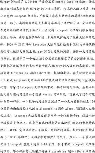
The Murray River drains the 1.06 × 10⁶ km2 Murray–Darling Basin and discharges into the sea at the Murray mouth in southeast South Australia. The outlet faces the 180 km-wide Lacepede Shelf and forms part of a wave-dominated beach barrier/lagoon complex, the largest of its type on the Australian coast. Global glacial cycles during the Pleistocene produced lowered sea-levels and exposure of much of the Lacepede Shelf, with the paleoshoreline advancing out to the present edge of the continental shelf during glacial maxima. Mapping and sediment sampling of the Lacepede Shelf in 2006 and 2007 allowed the ancient course of the Murray River on the shelf to be traced and studied for the first time, revealing a 200 km-long system of ancient infilled channels and lagoons. The main system of anastomosing Pleistocene channels begins southeast of the present Murray mouth, off Lakes Alexandrina and Albert, runs southward initially but then veers west-southwest across the central Lacepede Shelf before heading southwest directly south of central Kangaroo Island, and splaying into the head of Sprigg Canyon at the shelf edge. The Last Glacial Maximum channel starts near the current Murray mouth and forms part of this channel system. An earlier channel system ran a more direct, shorter 150 km south-southwest path from off Lakes Alexandrina and Albert to the shelf edge. The Lacepede Shelf is founded on a platform of gently folded, shallow-marine Miocene carbonates. The top of the platform is a prominent regional flat-lying erosional unconformity with local karstic relief in the order of 10 m. Unconsolidated sediment cover (?Pliocene–Quaternary) is mostly relatively thin or absent. However, a depocentre (Lacepede Basin), commonly 6–10 m thick, underlies the central Lacepede Shelf and that part of the shelf directly south of Lakes Alexandrina and Albert. This basin comprises estuarine, lagoonal/lacustrine and fluvial facies of the paleo Murray River, including channel-fill and point-bar deposits. Sediment drifts and residual paleo dunefields are common components of the young sediments on the shelf. A Holocene yellow/red fine quartz sand less than a metre thick, likely to have formed from reworked Last Glacial Maximum eolian sheets/dunes as well as lagoonal/lacustrine sediments, is the predominant sediment type at the surface of the central and northern Lacepede Basin. Paleochannels or paleovalleys of the Murray River incised into the Miocene carbonate platform are typically 10–20 m deep, 450–1000 m wide and contain up to 25 m of sedimentary fill and cover.
Acknowledgements
Southern Surveyor Voyages SS02/06 and SST02/07 were supported by the Marine National Facility (Hobart). Successful execution of the scientific programs at sea was greatly assisted by the professionalism and excellent cooperation of the master, Ian Taylor, and crew of Southern Surveyor. Don McKenzie of the Marine National Facility provided outstanding support in facilitating operational and logistic aspects of the cruises, and we thank his shipboard CSIRO electronic/computing staff for their competent and friendly assistance. We gratefully acknowledge the help provided by Geoscience Australia in relation to the shipboard work, including provision of its coring equipment so vital to the program. Thanks go especially to Peter Harris, Fred Kroh, David Holdway and Ray de Graaf. Michele Spinoccia provided expert multibeam support on both voyages, while Andrew Hislop and Craig Wintle skilfully operated the vibrocorer on the second voyage. Also contributing significantly to the success of the shipboard work were Australian National University (ANU) scientific staff Stephen Eggins and Nigel Craddy, plus a number of ANU geology students—John Rogers, Daniel Wilkins, Sarah Tynan, Doreen Roessler (affiliated to the Baltic Sea Institute), Sophie Bretherton, Louise Soroka and Graham Nash. We thank Neville Exon and John Magee, both of ANU, for their thorough and helpful reviews of an earlier version of the manuscript. Tony Belperio and Martin Williams kindly did the final reviews: their careful work and constructive comments were much appreciated.