
Abstract
This article describes a pilot study evaluating the sensitivity of Indigenous community health to climate change impacts on Salish Sea shorelines (Washington State, United States and British Columbia, Canada). Current climate change assessments omit key community health concerns, which are vital to successful adaptation plans, particularly for Indigenous communities. Descriptive scaling techniques, employed in facilitated workshops with two Indigenous communities, tested the efficacy of ranking six key indicators of community health in relation to projected impacts to shellfish habitat and shoreline archaeological sites stemming from changes in the biophysical environment. Findings demonstrate that: when shellfish habitat and archaeological resources are impacted, so is Indigenous community health; not all community health indicators are equally impacted; and, the community health indicators of highest concern are not necessarily the same indicators most likely to be impacted. Based on the findings and feedback from community participants, exploratory trials were successful; Indigenous-specific health indicators may be useful to Indigenous communities who are assessing climate change sensitivities and creating adaptation plans.
Introduction
Several parallel efforts among U.S. and Canadian IndigenousFootnote1 communities and federal, provincial, state, academic, and non-profit organizations are underway to identify and assess species, habitat, and human health and wellbeing sensitivities to climate change at local and landscape scales (cf., Carlson Citation2012; Dalton, Mote, and Snover Citation2013; Snover et al. Citation2013; Swinomish Indian Tribal Community [Swinomish] 2009; Turner and Clifton Citation2009). The project described herein cross-walks biophysical and social science by employing a set of recently developed Indigenous community health indicators (IHIs) to identify coastal climate adaptation priorities for Coast Salish communities. The indicators’ efficacy is tested in two Indigenous communities by evaluating community healthFootnote2 impacts and priorities based on projected climate change effects to shorelines, shellfish habitat, and archaeological resources in the Salish Sea region.
The project aims to test the efficacy of the IHIs in each community to determine whether: (1) the IHIs resonate with community members by accurately depicting non-physical aspects of Indigenous community health and (2) they illustrate how Indigenous community health is affected, and to what degree, when coastal climate change alters Indigenous foods, habitats, and archaeological resources. Myriad potential uses exist if trials of the IHI tool prove successful; most germane to this project is the use of IHIs to inform climate change adaption planning and decision-making for recovering natural biophysical processes that sustain aquatic natural resources and enhance community resilience.
The Swinomish Indian Tribal Community (Swinomish) in Washington State, led the work presented here, in collaboration with the Tsleil-Waututh First Nation in British Columbia, and the U.S. Geological Survey's Pacific Coastal and Marine Science Center and Western Fisheries Research Center. Partners provided expertise in climate scenario modeling and indicator sensitivity assessments for the physical shoreline, shellfish habitat, archaeological resources, and Indigenous community health.
Like many forays integrating social and biophysical sciences, this project required careful negotiation among researchers to ensure equitable input from all disciplines in the basic approach, methods, data analyses, and discussion of outcomes. Strang (2009) lays out foundational guidelines for interdisciplinary collaborations such as those followed for this project. This article intersperses paragraphs describing biophysical methods, results, and outcomes (i.e., the environmental indicators) with sociocultural methods, results, and outcomes (i.e., the IHIs), and relies heavily on Indigenous knowledge. While the focus is on development and implementation of the social science aspects, both social and biophysical sciences are necessary for the design, implementation, and outcomes of this project.
Background
The World Health Organization (WHO) defines health as, “a state of complete physical, mental and social well-being and not merely the absence of disease or infirmity” (WHO 1946) that is “a positive concept emphasizing social and personal resources as well as physical capabilities” (WHO Citation1998). Many Indigenous peoples define health and wellbeing similarly, including familial and community-wide considerations, reflecting interlinked social, cultural, spiritual, environmental and psychological aspects of health. Such Indigenous health systems are complex, structured in content and internal logic, and comprise practices and knowledge about connections between human beings, nature, and spiritual beings (cf., Arquette et al. Citation2002; Harris and Harper Citation2000; Turner et al. Citation2008).
How health is defined and assessed is a high priority for Indigenous communities, who are confronted with considerable health risks from impacts to homelands and beyond. Climate change is one of the largest-scale and potentially most devastating threats to the health and wellbeing of Indigenous peoples (Nakashima et al. Citation2012; United Nations Citation2009; USEPA 2012). Emerging health assessments focus on either: (1) individual, physiological health outcomes, which neglect community-scale, social, cultural, and mental health aspects; or (2) defining community health metrics qualitatively, which is beneficial to the community, yet difficult to replicate in other communities or at a geographically larger scale. Few Indigenous health evaluations are applicable beyond a localized area (two are: New Zealand's Whānau Ora Health Impact Assessment (New Zealand Ministry of Health Citation2007) and the First Nations Regional Longitudinal Health Survey in Canada (2005)), and very few evaluations integrate cultural priorities with natural resource management decision-making (one is the Maori Cultural Opportunity Mapping and Assessment (Tipa and Nelson Citation2008)). Although these frameworks represent crucial steps forward, no systematic method of evaluating and prioritizing climate driven-risks and impacts to Indigenous communities based on Indigenous health definitions exists. Such a method would more efficiently and effectively confront and plan for climate-related issues in Indigenous communities.
Climate change impacts to aquatic habitats and species have the “potential for significant impacts on subsistence fishing Tribes” (USEPA 2012, 18). Salmon, clams, and other species that rely on the shoreline during one or more life phases are examples of “first foods”—an integral part of an extensive network of Coast Salish values, beliefs, and practices (Garibaldi and Turner Citation2004). Additionally, archeological resources, also referred to as cultural properties, are of cultural and spiritual importance to the Coast Salish (cf., Stapp and Burney Citation2002). Many archaeological resource sites are located along shorelines and are at risk due to climate change. When these first foods, supporting habitats, or archaeological sites are impaired, the resultant amplification of negative effects reverberates throughout the social, cultural, mental, and physical aspects of Coast Salish life (Donatuto, Satterfield, and Gregory Citation2011; Turner et al. Citation2008).
For example, archaeological surveys along Burrard Inlet (British Columbia) shoreline have identified village sites, short-term camps, shell middens, pictographs, fish weirs, and clam gardens. The shoreline and beaches near the Tsleil-Waututh Indian Reserve have always been considered a “home” for Tsleil-Waututh community members, much like a house is to modern families. It is here that the community cares for their ancestors. Gathering and storytelling are frequent activities helping elders and youth connect. Community residents have expressed a feeling of disheartenment due to cultural losses as the shoreline changes.
Future scenarios of sea-level rise are summarized from West US Coast Sea Level Rise Assessment (National Academy of Sciences [NAS] 2012), which provides estimates for Washington's outer coast. Future sea-level rise projections for the Salish Sea remain uncertain due to complex vertical land motions (Mote et al. Citation2008) but are likely to be higher than the NAS projections due to land subsidence and reversal of recent depressed rates of west coast sea-level rise that appear to change with decadal-scale variations in regional wind stress (Bromirski et al. Citation2011). Recent measurements of global sea-level rise follow the maximum rise rate predictions of the 2007 IPCC and are accelerating (Church and White Citation2011), which suggests a likelihood of higher future sea levels than predicted.
Coastal Indigenous communities are disproportionally vulnerable to climate change and sea-level rise because many reserves reside in vulnerable coastal lowlands (Hanna Citation1997). Assuming conservative estimates of sea-level rise, an estimated 1,100 acres of the Swinomish Reservation, or approximately 15% of Reservation land, are potentially at risk of inundation from increasing sea-level rise (Swinomish 2009). On the Tsleil-Waututh Indian Reserve and nearby, nearly 75% of 311 acres of intertidal zone and 3 miles of steep shoreline are at risk.
Shoreline armoring is commonly employed to protect upland coastal property from erosion and inundation. In Puget Sound, it is estimated that one third of the shorelines are armored by seawalls, bulkheads, rip rap, and other materials (Berry Citation2000). Armoring is effective in protecting upland property, but ultimately deprives beaches of sediment and bulk wood delivery. When beaches lose local upland inputs, the chronic forces of tides, currents, and wind waves erode beaches in front of armored shorelines (Shipman Citation2010). As sea levels rise around Puget Sound, erosion due to shoreline armoring will intensify, expediting the loss of nearshore habitats, beach access and connectivity for recreational purposes.
In 2007, the Swinomish Indian Senate signed a proclamation directing action to study the possible effects of climate change on the Swinomish community, lands, resources, and tribal community health, and to determine appropriate responses. The Swinomish Impact Assessment Technical Report (Swinomish 2009) and Swinomish Climate Adaptation Action Plan (Swinomish 2010) evaluated a broad range of risks and potential adaptation strategies for the Reservation's lands and infrastructure. The reports have been widely circulated and used as a model template in tribal climate change adaptation strategies (e.g., University of Oregon Citation2013). These vanguard reports contain placeholders for areas of study that had yet to be explored; those pertinent to this study are shoreline impacts and Indigenous community health and wellbeing.
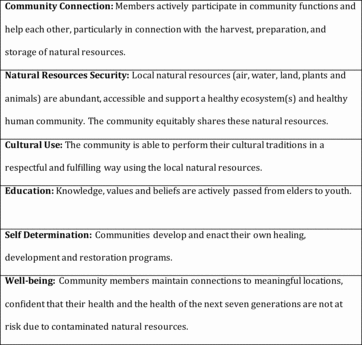
While most agree on the importance of considering the multi-faceted relations between humans and the environment (cf., Millennium Ecosystem Assessment Citation2005), the lack of an established methodology to do so often results in assessments omitting key aspects, or worse, violating beliefs and values (Satterfield et al. Citation2013; Turner et al. Citation2008). In 2004, authors Donatuto (Swinomish staff) and Campbell (Swinomish elder and staff) began interviewing Swinomish community members, researching ethnographic records, and studying health evaluation methods to develop health indicators reflective of the Tribe's non-physical definition of health (Donatuto, Satterfield, and Gregory Citation2011). Donatuto and Campbell then partnered with other Coast Salish Tribes to create an indicator set reflective of Coast Salish community health. Researchers identified six Indigenous Health Indicators (IHIs): Community Connection, Natural Resources Security, Cultural Use, Education, Self Determination, and Well-being () (Donatuto, Gregory, and Campbell In review).
The IHIs may be beneficial for a variety of assessments (e.g., use in health impact assessments, natural resource damage assessments, human health risk assessments, and climate change impact assessments). Swinomish chose to focus on climate change due to concurrent work on the Swinomish Climate Action Initiative.
Methods
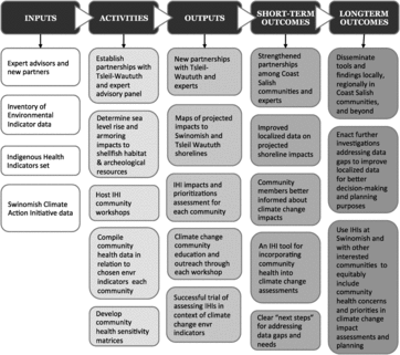
The methods are described by project task below and illustrated in the project's logic model ().
Task 1: Finalize Project Collaborations
Formalizing a partnership between two sovereign nations requires a clear and explicit memorandum of understanding that details the purpose of the project, data collection methods, access to the data, review and approval of the data, and dissemination approaches.Footnote3 For this project, both communities agreed that each community retained sole ownership over its own data, and that data would not be used in project analyses or released without prior review and approval by that community's leadership. Fostering such collaborations takes time and patience, and a clear understanding of each community's decision-making processes and protocols.
Task 2: Compile Existing Data on Chosen Environmental Indicators for the Two Project Communities
The U.S. Environmental Protection Agency and Environment Canada have identified a number of environmental indicators to evaluate the health and trends of the transboundary Salish Sea water body (Puget Sound Partnership Citation2012; USEPA 2013). Evaluating the status of environmental indicators is a first step toward prioritizing management and restoration actions to improve Salish Sea health. For this project, Swinomish and Tsleil-Waututh each selected two environmental indicators, inventoried available data relating to those indicators, and created projections of the status of those indicators relative to climate change. Criteria for indicator use included: (1) applicable to lands within reservation/reserve boundaries; (2) indicators appropriate for the Swinomish and Tsleil-Waututh communities; and (3) sufficient existing data supporting the indicator.
Swinomish selected shellfish beds and shoreline armoring as indicators. Swinomish has an established shellfish and nearshore monitoring program with nearly two decades of data on shellfish density, species composition, and shorelines profiles for several Reservation beaches.
Tsleil-Waututh selected shellfish beds and shoreline archaeological resources as indicators. The Nation has an objective of re-establishing traditional shellfish harvests that have been closed by water and sediment pollution for at least 40 years. Monitoring is ongoing and restoration plans are under development, but there is concern that sea-level rise will limit future opportunities and threaten to undermine numerous shoreline archeological sites.
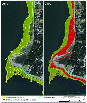
The case study area for the Swinomish portion of the project was Lone Tree Point, one of the most valued and highly utilized shellfish areas on the Swinomish Reservation, located on the western shore (). This study area was selected because of the availability of extensive shellfish monitoring data and a current digital elevation model, essential for generating maps of current status and future change. Frequent Tribal access for cultural and economic activities helped engage community members in the workshop.
Tsleil-Waututh studied the shoreline and intertidal area extending from Maplewood Flats to Cates Park on the north shore of Burrard Inlet just east of Second Narrows. Burrard Indian Reserve No. 3 is located along this stretch of shoreline and a majority of Tsleil-Waututh community members live here. The area once served as a tremendous source of natural resources as documented in the many archaeological sites located there. Like Swinomish, site significance helped generate interest in workshop participation.
Researchers synthesized digital datasets representing shellfish biomass, sediment characteristics, beach elevation, and shoreline armoring from existing sources to model climate change impacts to the chosen environmental indicators in each community (). Datasets were compiled into an Environmental Systems Research Institute geographic information systems (GIS) database and plotted using ArcGIS 10.1. Although the datasets represent the best available science with the highest level of resolution for the study area, maps, and results presented in this report were generated to provide a tool that characterizes relative differences in impacts and do not claim to predict actual impacts nor the response to all possible forcing parameters.
Table 1 Swinomish environmental indicator data sources (shellfish habitat and beach armoring)
Two shellfish species, butter clams (Saxidomus gigantean) and native littlenecks (Leukoma staminea), referred to here as shellfish, were chosen because they are, or were, the primary shellfish species harvested by Swinomish and Tsleil-Waututh for commercial, recreational, ceremonial, and subsistence uses. The shellfish habitat examined extends from subtidal depths to roughly 1.5 meters above Mean Low Lower Water (MLLW) in areas with mixed cobble, gravel, and finer sediment particles and commonly with broken shell. For analytical purposes, the lower elevation band of harvest area was set to the 0.3 meter elevation contour below MLLW, the level of extreme summer low tides at the study site. The upper elevation band of harvest area was set to 1.5 meters above MLLW.
At Swinomish, using a high-resolution Digital Elevation Model (Grossman and Horne In review), polygons were generated for the potential shellfish harvest areas along Lone Tree Point in ArcGIS using these upper and lower shellfish habitat bands. The shellfish harvest areas were refined further using the 1996 Washington State Department of Natural Resources, Aquatic Habitat Division, Shoreline Habitat Program's substrate polygons, removing areas of the beach where substrate types are unsuitable for shellfish habitat (such as bedrock). Shellfish biomass polygons from 2011 (Barber et al. Citation2012) were used to delineate and validate the newly generated polygons.
Researchers generated future shellfish harvest area polygons by taking the methodology described above and projecting the upper and lower shellfish contours higher on the beach face based on projected sea-level rise of 1.29 meters for the Salish Sea by 2100 (Mote et al. Citation2008; National Academy of Sciences Citation2012; Vermeer and Rahmstorf Citation2009). This value for year 2100 sea-level position is consistent with global rates of sea-level rise (Bindoff et al. 2007) and with vertical land movements (subsidence) within the Salish Sea (Mote et al. Citation2008) and the mid-value of Vermeer and Rahmstorf (Citation2009).
Project staff calculated shellfish harvest area from these projections, the change reflecting variations in area along shore due to beach morphology. The projected elevation bands also highlight areas where beach migration is limited due to shoreline armoring. Armoring in the Lone Tree Point study area includes 178 meters of rip-rap protecting the southern portion of Lone Tree Point, and 950 meters of bulkhead protecting property on the northern portion. Due to limited availability of multiple data layers akin to the Swinomish data, a similar, simpler exercise was completed at Tsleil-Waututh to define current shellfish habitat as well as projected habitat in 2100. Additional layers of archeological site polygons were added to the Tsleil-Waututh maps to show current location and projected inundation in 2100 from sea-level rise.
Task 3: Compile Community Health Data in the Context of the IHIs and Chosen Environmental Indicators
Each community analyzed how community health, as presented in the IHIs, may be connected to the chosen environmental indicators. This task was primarily a literature review combined with ground-truthing via interviews with community knowledge holders (for defining who is an expert, see: Davis and Wagner Citation2003). Literature review sources included community reports (e.g., Annual Reports, historic atlas), publications by government agencies (e.g., Health Canada, USEPA), and academic papers. At Swinomish, much of this information had been gathered during the creation of the IHIs; the list provided a template of source types and locations for Tsleil-Waututh.
Project staff evaluated each IHI in the context of current community health data, current environmental indicator data, and how community members might define and assess each IHI. The outcomes were descriptions that were unique to each community but still aligned with the overall IHI set. For example, at Swinomish the indicator that referred to gatherings and ceremonies and the reciprocal respect between people and natural resources is called Cultural Use. At Tsleil-Waututh, this indicator was termed Cultural and Spiritual Practices. Naming the health indicator in terms most used by community members avoids confusion as to what the indicator represents and, ultimately, respects how each community defines and talks about health.
Task 4: Pilot Testing the IHIs in the Context of Climate Change Facilitated Workshops
Each community hosted one workshop to test the IHIs in the context of shoreline environmental responses to climate change. Because this project was exploratory in nature, demographic representation was not necessary; staff personally invited 10–20 experts and elders to attend the workshop (). Researchers presented the workshop in PowerPoint, and participants answered questions using wireless, handheld polling devices. Responses were calculated using TurningPoint software, and summary results were immediately shown on the screen. Individuals’ answers remained anonymous. Workshops were structured as follows: (1) collect demographic data; (2) evaluate and rank the current health status in the community using the IHIs; (3) discuss maps and data of projected climate change impacts to: shoreline armoring (at Swinomish), shellfish habitat (Swinomish and Tsleil-Waututh), and archaeological resources (Tsleil-Waututh); (4) evaluate and rank projected status of the IHIs in the future, based on projected climate change-driven impacts; and (5) assess priority concerns of the IHIs in the context of the projected climate change impacts.
Table 2 Workshop demographics
Workshop participants used a constructed scale to evaluate the IHIs in parts 2 and 4 of the workshop. A constructed scale is a simple descriptive index (e.g., a Likert scale). Scales translate qualitative information into quantitative scores, without losing the information associated with the score, and without sharing proprietary information. Oral histories, scientific information, maps, and other images can be associated with a specific rating on a scale (Keeney and Gregory Citation2005; Gregory et al. Citation2012). Indigenous communities employing descriptive ranking techniques to assess priorities is not a new idea (e.g., McDaniels and Trousdale Citation2005). The scale used in the workshops corresponded with a statement about health status: “1—very bad,” “2—not very good,” “3—pretty good,” and “4—great.”Footnote4
Part 5 of the workshop used pair-wise comparisons for weighting the indicators (von Winterfeldt and Edwards Citation1986). Weighting is necessary to elucidate each indicator's relative importance. Not all of the indicators may have equal importance to the participants; knowing which indicators are the highest priorities benefits planning and decision-making. Based on pre-tests, participants found pair-wise comparisons the easiest weighting method to understand and complete (compared to swing weightingFootnote5). The weighting exercise enabled participants to prioritize the indicators of highest concern and the indicators most likely to be impaired (noting that these prioritizations may not be the same). A lower prioritization would not mean that the indicator is less important, only that it requires less immediate attention, due to greater resiliency or adaptive capacity to the specific climate change impacts presented.
The trial run of the IHIs would be considered successful if: (1) the participants felt that the indicators accurately reflected key aspects of community health; (2) the indicators were useful in thinking about impacts to health based on a specific context (in this case, climate change); and (3) the participants were comfortable with the ranking and weighting exercises.
Task 5: Community Health Impact Assessment
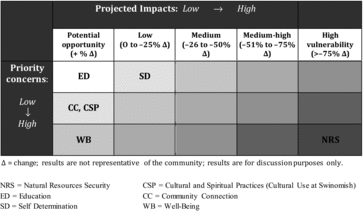
Results from parts 2, 4, and 5 of the workshop questions were used to generate an experimental impact assessment of the IHIs. Due to the exploratory nature of the project and small data sets, project researchers utilized simple avenues for experimenting with creating impact assessment metrics that aligned with the metrics used in the Swinomish Impact Assessment Technical Report (2009) and Climate Change Adaptation Action Plan (2010). The Swinomish reports employed a four-point descriptive scale of “low, medium, medium-high, high” in rating impact sensitivity (exposure/susceptibility), probability of impact, estimated risk, potential priority, and adaptive capacity for coastal and upland resources, physical health, and community infrastructure and services. A scale mirroring the Swinomish reports was used with an additional positive (non-negative impact) measure of “potential opportunity” to address indicators ranked as healthier in the future compared to today. Project researchers calculated the projected impacts for each indicator by comparing the total percent of answers ranked by participants with a 1 or 2 for the current health status to the total percent of answers ranked 1 or 2 for the projected future health. The result was a percent change, positive or negative, between the current and future health status of each indicator. Indicators with a positive percent change were rated as a “potential opportunity.” Indicators with a 25% or less decrease in health were ranked as “low.”Footnote6 Indicators with a 26% to 50% decrease in health were given a ranking of “medium.” Indicators in the range of 51% to 75% were labeled “medium-high,” and indicators above 76% were considered “high” on the impact ranking scale. Part 5, weighting the indicators, allowed project researchers to compare the “most highly impacted” indicator results to the indicators ranked as “highest priorities,” thus providing opportunities for focusing climate change planning efforts.
Results and Discussion
The analyses of environmental indicators focused on examining likely impacts of climate change on tribal shellfish and archeological resources. While sophisticated numerical models are required to forecast changes in shoreline morphology, this project used a simple estimate of projected sea-level rise inundation to test the utility of integrating environmental indicators with community health indicators.
Based on the mapping exercise, Lone Tree Point currently has 11.0 hectares of harvestable shellfish area situated across a low-sloping “low tide terrace” and a relatively steep mid and upper beach face. With a projected sea-level rise of 1.29 meters by 2100, the lowest extent of the harvest band across the low-tide terrace will become subtidal and inaccessible, and the upper harvest band will migrate landward where (lack of) armoring allows. Shellfish beds could be reduced to 8.0 hectares by the change in inundation alone by the year 2100, a 27% reduction driven primarily by inundation and loss of the large low-tide terrace area commonly accessed today (). This is likely an underestimate of impacts to shellfish and harvest area, as armoring can enhance scour that leads to substrate coarsening (Kraus and McDougal Citation1996), which indirectly increases the resuspension of fine sediment, both of which are unfavorable for shellfish.
At Tsleil-Waututh, the analyses of environmental indicators examined the impacts of climate change on community shellfish resources and archeological sites. The same caveats for the Swinomish analyses of environmental indicators apply. The results show a loss of 75% of current intertidal shellfish habitat, and damage to the majority of the archeological sites along the shoreline.
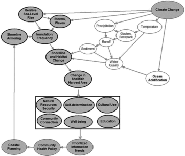
Shoreline morphology, shellfish habitat, and community adaptation decisions will be influenced by a complex interaction of sea-level rise, storms surge, waves and other climate change drivers. The influence diagram () provides an initial framework for characterizing and modeling drivers and outcomes of environmental and social processes. It also serves as a Bayesian and scenario-based modeling framework. This framework can be used to examine likely outcomes of scenarios as well as quantify the influence of uncertainty in individual drivers. Defining uncertainty helps to inform next steps in model refinement, data collection, and community needs. For example, a decision to maintain or remove shoreline armoring can be examined using IHIs to evaluate the community's priorities given tradeoffs between preserving coastal protection infrastructure or maintaining viable shellfish harvest area. Other biophysical processes affecting shellfish habitat and access to harvest due to projected changes in wave energy and shellfish substrate linked to runoff and sediment delivery are recommended for subsequent research to refine the shellfish harvest area projection results explored here.
Discussing the projected changes to the shoreline using maps as visual aids made strong impressions on the community members present at both workshops. Participant interest in the information sparked numerous conversations, at times bringing up suggestions for specific adaptation actions. Discourse between the project team and the community members was positive yet poignant—community members felt health would be affected by coastal climate change impacts, but remained hopeful about viable options to explore through the adaptation planning process.
The pilot project met all of the criteria to be considered a success. Participants felt the indicators accurately reflected key aspects of community health and were useful in thinking about health impacts from climate change. Participants were also comfortable completing the ranking and weighting exercises.
At the Swinomish workshop (results in ), participants ranked Cultural Use as most impacted in 2100, followed by Natural Resources Security, Self Determination, and Community Connection. As one community member explained, “Recognizing the indicators and talking about them is a way to start to deal with them. These things, impacts to our way of life, are way down deep and you maybe cannot see it, but it weighs on your whole spirituality; you get fatigued, spiritually worn out.” Participants emphasized that in the context of climate change and relative to other community health indicators, concern for Cultural Use was low. The group anticipated that Cultural Use would be less sensitive to harm from climate change. As one Swinomish participant said, “we don't worry as much about culture for this, it will always be with us.” However, beyond climate change concerns, the group remained very concerned about the state of Cultural Use and its impact on community health in general.
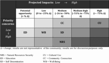
Community members were most concerned about projected climate change impacts to Natural Resources Security, followed by Self Determination, Well-being, and Education. Although Education was rated fairly high as a concern, community members ranked the health status of this indicator as improving in the future. One participant's comment provided insight: “Climate change is changing our resources. We are horrified, but the more you learn, the more you learn you can do something.” This highlights that the workshop itself can be considered an educational opportunity as well.
At the Tsleil-Waututh workshop (results in ), participants ranked Natural Resources Security as the indicator most impacted in the future. The highest concerns were for Natural Resources Security and Well-being. Climate change–induced reduction of everyday beach use and associated damage to archaeological sites weakens Tsleil-Waututh community health, as it disrupts Tsleil-Waututh members’ connections to their ancestors, a foundation/cornerstone of their cultural responsibility. The group ranked the Well-being health status as improving in the future (with the caveat that Well-being is not less of a concern in general). Education was ranked both as improving in the future and as a low concern in the context of the climate change projections. Participants stressed that Education is a top priority for the Nation and they remain concerned about the state of education and its impact on community health. The Tsleil-Waututh participants were positive about their health projections overall: Education, Community Connection and Cultural Use (called Cultural and Spiritual Practices at Tsleil-Waututh) were all ranked as improving in the future (). In future workshops, additional questions probing why people projected the health status of indicators to improve or decline will be included.
The style of the workshop—centered on a PowerPoint and using polling devices that collated numerical ranking data—limited the IHI exploratory trials in the ability to evaluate non-scripted discussions that arose (i.e., why participants felt that a particular health indicator would improve or decline over time). Weighting the IHIs was also a limitation. Although weighting is important in prioritizing and making choices, none of the weighting techniques proved ideal. In pre-trials, swing weighting proved more cognitively difficult than choosing between two options (paired comparisons). In order for the paired comparisons to work, however, all participants must complete the entire paired-comparison weighting exercise. If one or more participants decided not to answer one or more paired comparison questions, it was not possible to complete the calculations or a validity test in order to assess whether people answered in a logical and meaningful way. Yet, as part of the workshop process, no participant is required to answer all of the questions; it is strictly voluntary. Methods for incorporating information from discussions and the use of other weighting methods will be considered in future IHI workshops.
This project did not attempt to make comparisons between the two communities. Each community, even neighboring communities, is unique. Comparing differences between communities will not aid in evaluating the efficacy of the IHIs. The purpose of piloting the workshops in each community was to test whether the IHIs would reflect a community's particular concerns and priorities, so project researchers anticipated the results would not be the same in each community and that assumption was confirmed.
For researchers interested in working with Indigenous communities to enact similar studies, numerous sets of ethical research guidelines for community-based research exist (e.g., community-based participatory research [CBPR]; cf., Israel et al., Citation2005). While the subjects of respecting Indigenous knowledge and the complexities of evaluating such knowledge alongside western science are discussed extensively elsewhere (cf., Nadasdy Citation2003; Menzies Citation2006; Simonds and Christopher 2013), it can never be stated enough that Indigenous communities themselves have sovereignty over use of Indigenous knowledge and engagement practices. Given the negative historical and cultural consequences of researchers outside of Indigenous communities leading assessments, this is a critical juncture—facing tangible global climate change impacts—wherein the communities’ assertion of control must be respected and heeded. Footnote7
When Indigenous-based valuations such as the IHIs are employed in conjunction with environmental indicators, the complex linkages between community health and wellbeing and the economic and ecologic costs and benefits common to vulnerability assessments are more equitably promoted. Regionally, results may help moderate challenges faced by decision-makers and affected communities who often fail to communicate effectively in the absence of a common language about risks and impacts. As one participant stated, in some regards, lack of specific policy and regulations on both sides of the border about defining and assessing Indigenous health, or even social indicators more generally, provides an opportunity to introduce a tool such as the IHIs that is supported by communities and employs a common language.
The results of IHI development and testing may help to inform policies that promote coastal property development setbacks, buy-outs, or land swaps in order to accommodate long-term community health and ecosystem function as well as hazard mitigation. For Swinomish, the next steps will continue to integrate the biophysical and social sciences. Swinomish plans to initiate a project to assess the vulnerability of Swinomish first foods, coastal ecosystem habitats, and culturally significant sites in relation to sea-level rise, storm surge, and shoreline development. A representative sample of Swinomish community members will evaluate the results of these detailed assessments using the IHIs. Outcomes will inform gaps in the Swinomish Climate Change Adaption Action Plan (2010), which will in turn support coastal zone planning and decision-making on the Reservation.
In British Columbia, First Nations must take the lead on climate change adaptation and planning in an overall effort to address Indigenous community health. Both provincial (Carlson Citation2012) and local (HB Lanarc Consultants Citation2010) governments are developing strategies to address climate change. Carlson identifies “loss of cultural or historical sites on the coastline” as an impact to climate change, but does not go on to address any adaptation strategies specifically for this impact. Neither of these efforts attempts to address concerns unique to Indigenous communities like Tsleil-Waututh. Federal funds have been allocated through the Climate Change Adaptation Program within the Aboriginal Affairs and Northern Development Canada for First Nations to begin the process, but these funds are limited and allocated to the communities deemed most vulnerable to climate impacts. A systematic method such as the IHIs may help multiple First Nations begin their climate change assessment and adaptation planning in concert. While results will be unique to study participants, Indigenous communities along the Pacific coast are facing similar impending threats of climate change and the need to create adaptive land-use policies; the methods developed through this project are meant to be adapted and applied by other First Nations and Tribes across the region.
Acknowledgments
This article has been peer reviewed and approved for publication consistent with USGS Fundamental Science Practices (http://pubs.usgs.gov/circ/1367/). Many thanks to the workshop participants for sharing their views, and to Andrea Woodward, Sarah Fox, and peer reviewers for insightful comments on earlier drafts.
Funding
Research was funded by awards to the Swinomish Tribe from the North Pacific Landscape Conservation Cooperative and the NW Climate Science Center (#F12AP0094) and the U.S. EPA National Center for Environmental Research (#RD-83479101). The content is solely the responsibility of the authors and does not represent the official views of the Swinomish Indian Tribal Community, the Tsleil-Waututh First Nation, or the funding agencies.
Notes
“Indigenous peoples and nations are those which, having a historical continuity with pre-invasion and pre-colonial societies that developed on their territories, consider themselves distinct from other sectors of the societies now prevailing on those territories, or parts of them. They form at present non-dominant sectors of society and are determined to preserve, develop and transmit to future generations their ancestral territories, and their ethnic identity, as the basis of their continued existence as peoples, in accordance with their own cultural patterns, social institutions and legal system.” Martínez Cobo (1987) in United Nations (Citation2009).
Community health is defined here as the non-physical aspects of health on the scale of extended family, Tribe, or First Nation.
For guidance on developing and enacting culturally appropriate data and material sharing agreements with Indigenous communities, see Harding et al. (Citation2012).
In pretests, community members preferred to use a “forced choice” four point scale so that there is no neutral “middle road” option (Allen and Seaman Citation2007).
Swing weighting asks participants to imagine a change in each indicator from its worst to best levels, comparing the amount of benefit derived from the swing of the bottom indicator to the benefit derived from the swing of the top indicator (i.e., a ratio comparison), then to quantify the benefit as a percentage of the “swing value” of the top indicator.
A change in health of 10% or 15% could be considered much more than a “low” impact; this method would necessitate much more detailed scaling and ranking analyses if employed in actual assessments.
See Williams and Hardison (Citation2013) for a more comprehensive discussion of Indigenous knowledge, climate change, and the “cultural, legal, risk-benefit and governance contexts of knowledge exchange.”
References
- Allen, E., and C. Seaman. 2007. Likert scales and data analyses. Quality Progress 2007:64–65.
- Arquette, M., M. Cole, K. Cook, B. LaFrance, M. Peters, J. Ransom, E. Sargent, V. Smoke, and A. Stairs. 2002. Holistic risk-based environmental decision making: A Native perspective. Environmental Health Perspectives 11:259–264.
- Barber, J.S., T. Mitchell, J. Gibson, T. Hoyopatubbi, S. Gobert, and A. Ferderer. 2012. Clam population variability within a Puget Sound bivalve management region. La Conner, Washington: Swinomish Indian Tribal Community.
- Berry, H. 2000. Study of shoreline modification in Puget Sound based on EMAP Data. Olympia, Wash.: Washington Department of Natural Resources. http://www.dnr.wa.gov/Publications/aqr_nrsh_ps_emapdata.pdf (accessed December 15, 2013).
- Bindoff, N.L., J. Willebrand, V. Artale, A, Cazenave, J. Gregory, S. Gulev, K. Hanawa, C. Le Quéré, S. Levitus, Y. Nojiri, C.K. Shum, L.D. Talley and A. Unnikrishnan, 2007: Observations: Oceanic climate change and sea level. In Climate change 2007: The physical science basis. Contribution of Working Group I to the Fourth Assessment Report of the Intergovernmental Panel on Climate Change, . ed. Solomon, S., D. Qin, M. Manning, Z. Chen, M. Marquis, K. B. Averyt, M. Tignor and H. L. Miller. New York, NY: Cambridge University Press.
- Bromirski, P.D., A.J. Miller, R.E. Flick, and G. Auad. 2011. Dynamical suppression of sea level rise along the Pacific coast of North America: Indications for imminent acceleration. Journal of Geophysical Research 116 . (C07005).
- Carlson, D. 2012. Preparing for Climate Change: An Implementation Guide for Local Governments in British Columbia. West Coast Environmental Law. http://www.retooling.ca/_Library/docs/WCEL_climate_change_FINAL.pdf
- Church, J.A., and N.J. White. 2011. Sea-level rise from the late 19th to the early 21st century. Surveys in Geophysics 32(4–5):585–602.
- Dalton, M.M., P.W. Mote, and A.K. Snover (eds.). 2013. Climate change in the Northwest:Implications for our landscapes, waters, and communities. Washington, DC: Island Press.
- Davis, A., and J.R. Wagner. 2003. Who knows? On the importance of identifying “experts” when researching local ecological knowledge. Human Ecology 31(3):463–489.
- Donatuto, J., R. Gregory, and L. Campbell. In review. Developing responsive indicators of indigenous community health.
- Donatuto, J., T.A. Satterfield, and R. Gregory. 2011. Poisoning the body to nourish the soul: Prioritising health risks and impacts in a Native American community. Health, Risk & Society 13(2):103–127.
- First Nations Regional Longitudinal Health Survey. 2005. Results for Adults, Youth and Children living in First Nations Communities. Ottawa. http://www.naho.ca/firstnations/english/regional_health.php (accessed December 15, 2013).
- Garibaldi, A., and N.J. Turner. 2004. Cultural keystone species: Implications for ecological conservation and restoration. Ecology and Society 9(3):1–18.
- Gregory, R., L. Failing, M. Harstone, G. Long, T. McDaniels, and D. Ohlson. 2012. Structured decision making: A practical guide to environmental management choices. Chichester, West Sussex, UK: Wiley-Blackwell Press.
- Grossman, E.E., and P. Horne. In review. New high-resolution digital elevation models for large river deltas in Puget Sound: Coastal inundation sensitivity and vulnerability assessment. U.S. Geological Survey.
- HB Lanarc Consultants. 2010. Community Climate Change Action Plan: Foundations Report. District of North Vancouver. http://identity.dnv.org/upload/pcdocsdocuments/4wh01!.pdf (accessed December 15, 2013).
- Hanna, J.M. 1997. Native Communities and Climate Change: Protecting Tribal Resources as Part of National Climate Policy. Natural Resources Law Center, University of Colorado Law School.
- Harris, S., and B. Harper. 2000. Using eco-cultural dependency webs in risk assessment and characterization of risks to Tribal health and cultures. Environmental Science and Pollution Research 2:91–100.
- Harding, A.K., B. Harper, D. Stone, C. O’Neill, P. Berger, S. Harris, and J. Donatuto. 2012. Conducting research with tribal communities: Sovereignty, ethics, and data-sharing issues. Environmental Health Perspectives 120(1):6–10.
- Israel, B.A., E. Eng, A.J. Schulz, and E.A. Parker. 2005. Methods in community-based participatory research for health. San Francisco, CA: Jossey-Bass.
- Keeney, R.L., and R.S. Gregory. 2005. Selecting attributes to measure the achievement of objectives. Operations Research 53(1):1–11.
- Kraus, N.C., and W.G. McDougal. 1996. The effects of seawalls on the beach—Part 1, an updated literature review. Journal of Coastal Research 12(3):691–701.
- Martínez Cobo, J. 1987. Study of the Problem of Discrimination against Indigenous Populations. United Nations.
- McDaniels, T., and W. Trousdale. 2005. Resource compensation and negotiation support in an aboriginal context: Using community-based multi-attribute analysis to evaluate non-market losses. Ecological Economics 55:173–186.
- Menzies, C.R. (ed.). 2006. Traditional ecological knowledge and natural resource management. Lincoln: University of Nebraska Press.
- Millennium Ecosystem Assessment. 2005. Ecosystems and human well-being: Synthesis. Washington, DC: Island Press.
- Mote, P.W., A.(S.) Petersen, S. Reeder, H. Shipman, and L.C. Whitely Binder. 2008. Sea Level Rise in the Coastal Waters of Washington State. Report prepared by the Climate Impacts Group, Center for Science in the Earth System, Joint Institute for the Study of the Atmosphere and Oceans, University of Washington, Seattle, Washington and the Washington Department of Ecology, Lacey, Washington
- Nadasdy, P. 2003. Hunters and bureaucrats: Power, knowledge, and aboriginal-state relations in the Southwest Yukon. Vancouver, BC: University of British Columbia Press.
- Nakashima, D.J., K. Galloway McLean, H.D. Thulstrup, A. Ramos Castillo, and J.T. Rubis. 2012. Weathering uncertainty: Traditional knowledge for climate change assessment and adaptation. Paris; Darwin: UNESCO; UNU.
- National Academy of Sciences. 2012. Sea-Level Rise for the Coasts of California, Oregon, and Washington: Past, Present, and Future. Report from the Committee on Sea Level Rise in California, Oregon, and Washington; Board on Earth Sciences and Resources; Ocean Studies Board; Division on Earth and Life Studies: National Research Council.
- New Zealand Ministry of Health. 2007. Wh¯nau Ora Health Impact Assessment. Wellington: Ministry of Health.
- Puget Sound Partnership. 2012. Puget Sound Action Agenda. 213 p. http://www.psp.wa.gov/downloads/AA2011/083012_final/Action%20Agenda%20Book%202_Aug%2029%202012.pdf (accessed November 18, 2012).
- Satterfield, T., R. Gregory, S. Klain, M. Roberts, and K.M. Chan. 2013. Culture, intangibles and metrics in environmental management. Journal of Environmental Management 117:103–114.
- Shipman, H. 2010. The geomorphic setting of Puget Sound: Implications for shoreline erosion and the impacts of erosion control structures. In Puget Sound Shorelines and the Impacts of Armoring—Proceedings of a State of the Science Workshop, May 2009: U.S. Geological Survey Scientific Investigations Report 2010–5254, eds. H. Shipman, M.N. Dethier, G. Gelfenbaum, K.L. Fresh, and R.S. Dinicola, 19–34.
- Simonds, V.W., and S. Christopher. 2013. Adapting western research methods to indigenous ways of knowing. American Journal of Public Health 103(12): 2185–2192.
- Snover, A.K, G.S. Mauger, L.C. Whitely Binder, M. Krosby, and I. Tohver. 2013. Climate Change Impacts and Adaptation in Washington State: Technical Summaries for Decision Makers. State of Knowledge Report prepared for the Washington State Department of Ecology. Climate Impacts Group, University of Washington, Seattle.
- Strang, V. 2009. Integrating the social and natural sciences in environmental research: A discussion paper. Environment, Development and Sustainability 11:1–18.
- Stapp, DarbyC., and M.S. Burney. 2002. Tribal cultural resource management: The full circle to stewardship. Washington, DC: Altamira Press.
- Swinomish Indian Tribal Community. 2009. Impact assessment technical report. La Conner, WA: Swinomish Indian Tribal Community.
- Swinomish Indian Tribal Community. 2010. Climate change adaptation action plan. La Conner, WA: Swinomish Indian Tribal Community.
- Tipa, G., and K. Nelson. 2008. Introducing cultural opportunities: A framework for incorporating cultural perspectives in contemporary resource management. Journal of Environmental Policy & Planning 10(4): 313–337.
- Turner, N.J., and H. Clifton. 2009. ‘‘It's so different today’’: Climate change and indigenous lifeways in British Columbia, Canada. Global Environmental Change 19:180–190.
- Turner, N.J., R. Gregory, C. Brooks, L. Failing, and T. Satterfield. 2008. From invisibility to transparency: Identifying the implications. Ecology and Society 13(2): 7. [online] http://www.ecologyandsociety.org/vol13/iss2/art7/ (accessed June 9, 2014).
- USEPA (United States Environmental Protection Agency). 2012. Draft Climate Change Adaptation Plan. Washington, DC.
- USEPA and Environment Canada. 2013. Health of the Salish Sea Ecosystem Report. http://www2.epa.gov/salish-sea (accessed June 15, 2013).
- United Nations. 2009. State of the World's Indigenous Peoples New York: Department of Economic and Social Affairs, Division for Social Policy and Development, Secretariat of the Permanent Forum on Indigenous Issues.
- University of Oregon. 2013. A Tribal Planning Framework—Climate Change Adaptation Strategies by Sector. In PNW Tribal Climate Change Project, April 2013. Eugene, OR: University of Oregon.
- Vermeer, M., and S. Rahmstorf. 2009. Global sea level linked to global temperature. Proceedings of the National Academy of Sciences 105(51): . 21,527–21,. 532.
- von Winterfeldt, D., and W. Edwards. 1986. Decision analysis and behavioral research. New York: Cambridge University Press.
- WHO (World Health Organization). 1946. Constitution of the World Health Organization. World Health Organization, New York.
- WHO. 1998. Health Promotion Glossary. World Health Organization, Geneva.
- Williams, T., and P. Hardison. 2013. Culture, law, risk and governance: Contexts of traditional knowledge in climate change adaptation. Climatic Change 120:531–544.