
ABSTRACT
Coastal protection of communities and property using “green infrastructure” approaches is gaining popularity as the science and practice improve. Guidance is limited for decision makers interested in taking action to protect shorelines. Here, we offer practical guidance for decision makers interested in moving beyond generalities for coastal protection strategies. We present three case examples from the U.S. Gulf of Mexico and in Belize, each posing different questions, and thus using different approaches, to evaluate whether green infrastructure strategies could be useful. For basic questions about where habitat-based approaches are likely to add value, index-based models are useful in identifying priority areas for habitat protection or restoration. Process-based models are best used to examine strategies where the interest is in the likely magnitude of value from gray and green infrastructure approaches. Process-based models in coastal Texas demonstrate that marsh habitats are spatially variable in their ability to reduce the height and costs of levees necessary to protect property from storms and sea-level rise. Such spatial variation in the value of green infrastructure can be readily incorporated in a variety of decisions, allowing action now, before more science and lessons from applications emerge.
Introduction
Decision makers from the public and private sector are beginning to explicitly consider the protection that “green” infrastructure such as salt marshes, reefs, mangroves, and dunes can provide to coastal areas. Governments from the USA to Australia are requiring evaluation of and are investing in green infrastructure approaches for protecting communities and built infrastructure (Addison and Walshe Citation2015; Bridges et al. Citation2015; Commonwealth of Australia Citation2015; FEMA Citation2015; NOAA Citation2015; NSTC Citation2015). Multilateral institutions such as the Inter-American Development Bank provide loans and grants to member states in Latin America and the Caribbean to protect natural habitats for improved coastal resilience to sea-level rise and storms. Private sector decision makers, from the insurance and re-insurance industry to private landowners concerned about the security of their physical properties, are exploring the cost-effectiveness of green infrastructure as part of their protection strategies (Gordon, Lewis, and Rogers Citation2014). In spite of this increased interest by managers and investors and growing public awareness, significant gaps remain in translating the latest science to effective changes in the way shorelines are protected.
The potential direct benefits coastal habitats can provide to people through reducing erosion and flooding are well documented in the literature (Barbier et al. Citation2011; Costanza et al. Citation2008; Shepard, Crain, and Beck Citation2011; Spalding et al. Citation2013; Wamsley et al. Citation2010). Beyond coastal protection services, the case for these natural capital approaches includes: (1) their ability to provide additional ecosystem service benefits such as recreation, fisheries, and carbon storage and sequestration (Aburto-Oropeza et al. Citation2008; Barbier et al. Citation2011; Sanchirico and Mumby Citation2008); (2) the ability of coastal environments to self-sustain and adapt to climate change processes with minimal human intervention (Borsje et al. Citation2011); and (3) the potential benefits of deploying hybrid green and gray infrastructure approaches that augment one another for greater protection at lower cost (Bouma et al. Citation2014).
Beyond the scientific literature, headline stories on the benefits marine habitats such as marshes, wetlands, coral and oyster reefs, mangroves, and dunes provide to people and property in the face of major storms and tsunamis are increasingly prevalent in mainstream media (Feuer Citation2014; Gallucci Citation2015; Seabrook Citation2013). Missing from these public narratives is the important detail that spatial context greatly affects the potential value of ecosystem services as a solution to consider (Plummer Citation2009). The next generation of ecosystem service science—demonstrating feasibility, but also nuances in the conditions for success of these approaches (Guerry et al. Citation2015)—has now leaped ahead of the public discourse. This disconnection between the state of the science and practice has left a gap in guidance for implementing habitat-based solutions for coastal protection (Moser, Williams, and Boesch Citation2012).
In this paper, we review several recent case examples to illuminate how the protective benefits of coastal habitats vary dramatically over space and geographic context. A growing number of studies demonstrate the feasibility of quantifying the protective roles of coastal habitats in ways that resonate with diverse decision makers (Arkema et al. Citation2013, Citation2015; Barbier Citation2012; Barnett et al. Citation2014; Guannel et al. Citation2014; Koch et al. Citation2009; Langridge et al. Citation2014). It is clear from these studies that the value of natural habitats in providing protection is very site- and context-specific. Whether green infrastructure could contribute to coastal protection depends on the physical and social vulnerabilities of an area, cost constraints, and the nature of the storm or sea-level rise hazard to be withstood (Arkema et al. Citation2013; Barbier et al. Citation2011; Reddy et al. Citation2016). These studies also show how different problems require different analytical approaches, and how an ensemble of currently available tools can be used in a wide array of contexts and geographic scales to capture the ecosystem service benefits of green infrastructure projects. For brevity, we offer examples using the InVEST tool (Arkema et al. Citation2013; Guannel et al. Citation2015; Sharp et al. Citation2016) within broader decision processes. Other approaches and tools exist (Margles Weis et al. Citation2016) and also are being used to inform decisions.
Coastal vulnerability and protection: Matching models to questions
The case studies given below offer guidance for planners, investors, or developers wondering whether they should consider green infrastructure as part of their portfolio of solutions for coastal development and hazard mitigation. Each example demonstrates how different objectives related to coastal protection can be matched with the scientific approaches most appropriate to the questions posed. The good news is, multiple, scientifically rigorous approaches are available to respond to different challenges from decision makers.
Case example 1: Where should those developing coastal protection or restoration strategies consider green infrastructure approaches?
State- and regional-scale restoration planning and investments are ramping up in the U.S. Gulf of Mexico (NRC Citation2014). The U.S. RESTORE Act is providing billions of dollars to affected states in the Gulf for restoration of damaged coastal habitats through legal settlements under the Deepwater Horizon Oil Spill disaster (Day et al. Citation2007; US Government Citation2012). State- and county-level boards and departments (e.g., Louisiana's Coastal Protection and Restoration Authority Board, Florida's Department of Environmental Protection) and the joint federal/state Gulf Coast Ecosystem Restoration Council are charged with prioritizing and disbursing those funds. The Nature Conservancy (TNC Citation2015) is working in a number of Gulf states and counties to help prioritize areas and funding for coastal habitat restoration (Kroeger Citation2012; Reguero et al. Citation2014; Thompson, Brenner, and Gilmer Citation2014; TNC Citation2015). Whether a protection and restoration strategy should include green infrastructure can be informed by first asking: Where do coastal habitats provide significant risk reduction for people and coastal assets? Identifying the stretches of shoreline to prioritize for habitat conservation or restoration for the service of natural hazard reduction requires knowing where habitats are most likely to: (1) lessen exposure to erosion and flooding from storms and future sea levels, and (2) protect vulnerable people and property (Arkema et al. Citation2013).
Several distinct, relatively complex models could be applied to help address these questions. However, to develop coastal protection priorities at relatively large scales, it makes sense to match the analysis to the questions by starting simple. Index-based approaches that combine maps of major coastal habitat types with physical, climate, and social data in scientifically rigorous ways (Liquete et al. Citation2013) do not require complex modeling of coastal processes and can thus be a good place to start. One such model, the InVEST coastal vulnerability model, is an open-source toolFootnote1 (Arkema et al. Citation2013; Sharp et al. Citation2016) that builds on previous approaches (Gornitz Citation1990; Hammar-Klose and Thieler Citation2001) by specifically including the role of habitats in providing protection. The model generates a coastal vulnerability index that includes seven bio-geophysical variables representing the natural biological and geomorphic characteristics of a region (such as shoreline type and relief), the effect of storms by incorporating observed data on waves (Tolman Citation2009) surge potential, wind forcing, and information on sea-level rise, which together identify the shoreline areas most likely to be prone to erosion and inundation (). The model uses observed and modeled data to rank shoreline segments using a qualitative estimate of exposure in terms of a vulnerability index, which differentiates areas with relatively high or low exposure to erosion and inundation during storms. By coupling these results with population information, the model highlights areas along a given coastline where humans are most vulnerable to storm waves and surge.
Table 1. Factors affecting spatial distribution of vulnerability to hazards along a coastline.
Table 2. Factors affecting flooding and erosion damages in a specific location along a coastline.
We applied and tested this index-based approach for the entire coastline of the USA, and results indicate extensive heterogeneity in the contribution of habitats to reducing exposure of communities in the coastal zone to sea-level rise and storms (Arkema et al. Citation2013). Results of vulnerability indices like this can be used to make first estimates of where investments in habitat restoration will have the greatest benefits. For example, the InVEST coastal vulnerability model indicates a relatively consistent moderate-to-high exposure of the Texas coast to coastal hazards compared with other parts of the Gulf Coast. Thus, at this regional scale, habitat restoration and protection efforts in Texas might be prioritized over efforts in, for example, the west coast of Florida, where exposure to hazards is relatively lower ().
Figure 1. Coastal vulnerability and protective role of habitats. (A) Total exposure of the Gulf Coast of the USA to sea-level rise and storm hazards if protective habitats were lost (adapted from Arkema at al. Citation2013). (B) Exposure of Galveston Bay shoreline to waves (adapted from Guannel et al. Citation2014). Panel A exposures are calculated relative to all coastal segments in that portion of the Gulf of Mexico. Panel B exposures are computed using only Galveston Bay coastal segments for comparison, and holding storm and sea-level rise attributes constant, since they are uniform in the bay. (C) Within Galveston Bay, the moderating role of habitats in reducing exposure, from high to none (from Arkema et al. Citation2013).
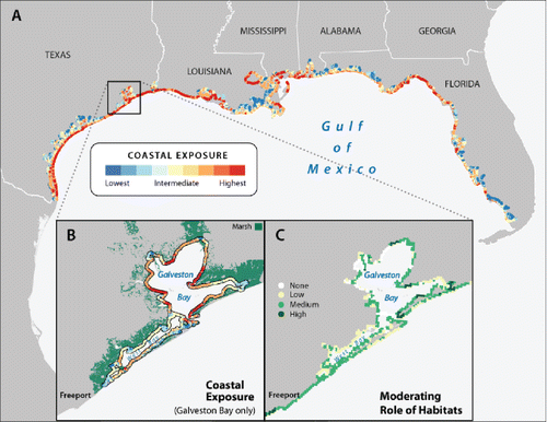
An index-based shoreline ranking approach can also be useful at smaller scales. For example, within the highly exposed Galveston Bay region, public and private property owners are interested in siting oyster reef habitat restoration projects to reduce the impacts of waves on their shores, thereby reducing their vulnerability to erosion from storms and sea-level rise (Ravens et al. Citation2009; Roland and Douglass Citation2005; Thompson et al. Citation2014; TNC Citation2015). Without running complex wave models, a simple ranking of the shoreline based on exposure outputs of the InVEST coastal vulnerability model can highlight portions of Galveston Bay where oyster reef or wetland restoration is most likely to effectively reduce damage from waves (Ravens et al. Citation2009; Roland and Douglass Citation2005; Thompson et al. Citation2014). For example, zooming in along the eastern Texas shoreline around Galveston Bay, coastal areas within West Bay are less exposed to hazards than shorelines within Galveston Bay proper that are more open to the Gulf waters (). In addition to variation in exposure to coastal hazards, the potentially moderating role of habitats varies spatially in that same region along the east Texas coast. When looking at locations in Texas where habitat restoration efforts would yield the greatest amount of protection from coastal hazards, sites near the mouth and eastern side of Galveston Bay might be better candidates than in West Bay (). Our collaborators at TNC are using these results as part of their rationale for siting oyster reef and wetland restoration projects (CBS Citation2013; Thompson et al. Citation2014; TNC Citation2015).
Index-based screening approaches can be useful to answer the basic question of where habitat conservation or restoration efforts might be effective at protecting stretches of shorelines and reducing the impact of hazards on communities. The simple maps generated can also be good communication tools showing the various ways and scales at which natural habitats can reduce risk.Footnote2 An index modeling approach also can help focus protection strategies on those factors that can be altered to reduce hazard exposure (e.g., type of habitat), and which are immutable consequences of location to be planned around (e.g., shoreline type) (). However, for more detailed questions about how much protection is likely from green infrastructure, a different type of modeling approach is needed, as we discuss in the next case.
Case example 2: How much protection can a green infrastructure approach provide to a specific location?
Although an index-based approach can be useful for screening areas where habitats are likely to reduce risk to coastal hazards, categorical output metrics are not always sufficient to support more detailed questions of magnitude. One such example emerged through our work with the Dow Chemical Company, which has an extensive chemical plant in Freeport, Texas (Reddy et al. Citation2016). Most of Dow's facility in Freeport is protected by levees; however, a key area is outside the levee system, leading Dow to wonder what role green infrastructure might play in combination with their levees in reducing risk to coastal storms and sea-level rise. In collaboration with TNC and Dow, we examined whether marshes could provide flood protection from rising sea levels and hurricanes as part of a hybrid protection approach with levees. In particular, Dow was interested in the amount of flood reduction that could be achieved under alternate conservation and restoration scenarios of their properties in the area (Reddy et al. Citation2016). In this case, where local topography and habitat distribution affected the magnitude-of-effect question Dow posed, a more detailed modeling approach was necessary.
The model we used here, the InVEST Coastal Protection model (Guannel et al. Citation2015), captures how vegetation can protect communities by reducing nearshore water levels and erosion. The model allows users to quantify how vegetation modifies nearshore processes, including the attenuation of wave height and total water level, as well as changes in shoreline position and sediment loss during storms. Factors affecting wave height, water level, and sediment loss in the model include relief, substrate type, and location and characteristics of natural habitats (). Two sub-models generate estimates of the magnitude of erosion and flooding: a Profile Generator and a Nearshore Wave and Erosion model. The Profile Generator combines information about local bathymetry and backshore characteristics to generate a 1D beach profile perpendicular to the shoreline. The Nearshore Waves and Erosion sub-model uses the cross-shore profile to compute summaries of nearshore wave information. This sub-model calculates for a given change in habitats (e.g., coral or oyster reefs, marsh, sand dunes) the total water level at the shore, the amount of shoreline erosion, and the avoided erosion damages at the site.
Results of the model in the Freeport region demonstrate that, although wetlands there can provide significant coastal protection benefits to properties located closer to the shoreline, wetlands supply a negligible protective value to the Dow facility, which is further inland (). Indeed, during most storm conditions, wetlands moderate the impacts of waves and protect communities close to the coast by reducing the amount of damages they suffer, or by reducing the height of protective structures that they would need to build by nearly 40%. However, coastal habitats would not significantly reduce the relative height required for protective levees near the Dow facility, which is 12 km inland and is only affected by the most powerful hurricanes (Reddy et al. Citation2016). As waves travel inland through residential areas and other intervening landscapes, the influence of the coastal wetlands on inundation at the Dow facility becomes negligible, reducing the protective height required for levees by just 2% ().
Figure 2. Spatial heterogeneity in the protective value of marsh habitats. (A) Sample percent levee height reductions due to the presence of marshes near Freeport (red boxes; Reddy et al. Citation2016), and West Bay (blue boxes; adapted from Guannel et al. Citation2014), Texas as indicated by the InVEST Coastal Protection model. Percent reduction values were calculated by taking the difference in levee heights required to protect communities in the presence and absence of marsh habitats. In Freeport (red boxes), levee heights were computed to protect against a 100-year storm, the only magnitude storm that can reach the Dow Chemical facility. In West Bay, levee heights were computed to protect against a category 3 hurricane, a storm magnitude of greatest interest to decision makers. (B) Bathymetry and topography contribute to different protective values of wetlands in West Bay, Texas (adapted from Guannel et al. Citation2014). Elevation profiles 1 and 2 depict the footprint of marsh (green) and surge level during modeled storms (thin black line). The more gradual elevation change and greater marsh extent in profile 2 offers a greater opportunity for marsh habitat to reduce levee height for equivalent storm protection (50% reduction in levee height) as compared to the steeper gradient in profile 1 (15% reduction in levee height).
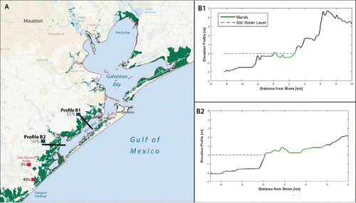
That unique local biogeographic conditions drive the value of coastal habitats for protection is further illustrated by the results of a similar analysis in Galveston Bay. Here, decision makers were interested in knowing the potential value of wetlands in reducing the size of a levee required to provide protection during a typical, moderate-strength hurricane. Results of the InVEST Coastal Protection model showed spatial heterogeneity in the amount of protection benefits from wetlands within Galveston Bay (Guannel et al. Citation2014). For example, where the topography is steep and wetlands are sparse, their presence negligibly reduces the size of a protective levee needed (). In contrast, in nearby parts of the coastline where wetlands are more extensive and the elevation change is more gradual, the presence of wetlands can reduce the required height of a protective levee by up to 50% (). Such results demonstrate the added value of a process-based modeling approach to include the protective value of coastal habitats, and how they can be used to improve cost-effectiveness of built protective measures such as levees in storm-prone regions. Wetlands can make a significant difference in the levee height (and thus cost) required in some locations, and very little in others; process-based models can help identify which situation pertains to particular locations.
Case example 3: How can different models for green infrastructure approaches be used together to provide guidance on where and how much coastal protection is likely?
The different index- and process-based models discussed in the cases 1 and 2 can be useful in the same place at different stages of a decision-making process. For example, we worked in close collaboration with the national government of Belize and regional planning bodies to help design the country's first Integrated Coastal Zone Management plan (ICZM; Clarke, Canto, and Rosado Citation2013). One of the goals of the planning process was to use a suite of ecosystem service metrics as multiple objectives by which to evaluate and improve alternative management scenarios for human activities. Protection from storms provided by coastal habitats was one of the three ecosystem services we modeled, in addition to spiny lobster catch and revenue and tourism visitation and expenditures (Arkema et al. Citation2015).
Initially, we used the InVEST coastal vulnerability model (Arkema et al. Citation2013) and the resulting vulnerability maps to communicate with local stakeholders and our government partners at the Coastal Zone Management Authority and Institute (CZMAI) about the role of coastal habitats in reducing risks from ocean hazards. CZMAI also used the coastal vulnerability index as an approach for assessing where coastal ecosystems were most important for reducing storm exposure to hospitals, schools, roads, and other coastal infrastructure. Later, we used results from the more detailed InVEST Coastal Protection model (Guannel et al. Citation2015) to quantify differences in avoided damages and area of land protected by corals, mangroves, and seagrasses among alternative management scenarios for the ICZM plan (Arkema et al. Citation2015). The quantitative economic metrics for green infrastructure provided by InVEST Coastal Protection model were useful in engaging officials from different ministries who were using such metrics in their day-to-day decisions.
In an example from another location, The Nature Conservancy combined a similar, index-based approach with quantitative modeling to cite a coral reef restoration project in the Caribbean island of Grenada. Through community engagement and collection of physical, social, and climatic data, they first mapped the relative vulnerability of all coastal districts. From these maps, they were able to identify regions that were both highly exposed and sensitive to storms and sea-level rise and where adaptive capacity was low (Margles Weis et al. Citation2016). Of these, they chose Grenville Bay as the location to construct an artificial breakwater for erosion reduction and coral colonization. Using coastal engineering approaches and models, they identified a location within the bay where the reef would have the greatest influence on coastal erosion reduction and mangrove recruitment and growth. They also used the engineering models to develop design characteristics (e.g., width of breakwater, height relative to water level, etc.) for the breakwater.
Conclusions
The science and practice are clear that protection or restoration of natural habitats can be a cost-effective complement to built infrastructure approaches for protecting communities and infrastructure from coastal hazards. Spatial context is everything in determining whether green infrastructure makes sense in a given place. The condition and location of natural habitats and built infrastructure, communities, and cost of property can affect green and gray strategies' value in protecting communities from coastal hazards. Even though coastlines around Freeport and Galveston, Texas appear similar in terms of the potential value of habitats for coastal protection from an index-based approach, more process-based analyses showed more specifically where, and how much, coastal habitats could be used in conjunction with levees to reduce risk. Both the science and practice of using habitats in coastal protection can now advance beyond platitudes about “green is good,” to nuanced and educated discussions of “where, and how much” green infrastructure can improve cost-effectiveness of coastal protection strategies.
As scientific approaches have grown in sophistication in response to decision maker demands, different approaches and tools are now available to match clearly distinct objectives for green infrastructure (Arkema et al. Citation2015; Barnett et al. Citation2014). Such modeling tools can now be used to identify specific priority areas across a large geography to guide initial and on-going stakeholder conversations about where to focus activities to efficiently enhance a region's “gray” infrastructure with green infrastructure approaches (TNC Citation20152). These tools can assist stakeholders in identifying the right projects in the most appropriate locations to include in proposals for funding restoration or protection strategies.
The guidance offered through examples given here is just the beginning. A number of coastal habitats (e.g., mangroves, coral reefs, and seagrasses) are well documented in providing coastal protection services that also vary depending on the spatial context (Arkema et al. Citation2013, Citation2015; Barbier et al. Citation2011; Ferrario et al. Citation2014; Guannel et al. Citation2015). Geographic differences in costs of gray infrastructure development, restoration approaches, and the value of properties to be protected also contribute to spatial heterogeneity in the total value of green infrastructure approaches (Arkema et al. Citation2013; Kroeger Citation2012).
Public and private sector decision makers increasingly are realizing that the value of coastal habitats to their communities is multifaceted. Coastal wetlands, dunes, mangroves, and reefs provide habitat for commercially and recreationally important fish, birds, and other wildlife, filtration of land-based pollutants, and climate regulation through carbon storage and sequestration, in addition to shielding people and property from coastal hazards (Barbier et al. Citation2011; Barnett et al. Citation2014; Bilkovic and Mitchell Citation2013; Reddy et al. Citation2016). In cases where the value of coastal habitats has included accounting for multiple benefits, it is even more likely that green approaches add social value (Arkema et al. Citation2015). Communities and the coastal regions contributing to their resilience will benefit through identifying strategies to move from single objective planning to integrated planning for multiple ecosystem service benefits for nature and people. There are enough science and tools to support action toward these ends now, even as more learning through application continues.
Notes
1. Available at www.naturalcapitalproject.org
2. For example, The Nature Conservancy has developed a Coastal Resilience Viewer that incorporates coastal vulnerability calculations from the InVEST models (TNC Citation2015).
References
- Aburto-Oropeza, O, E. Ezcurra, G. Danemann, V. Valdez, J. Murray, and E. Sala. 2008. Mangroves in the Gulf of California increase fishery yields. Proceedings of the National Academy of Sciences 105:10456–10459.
- Addison, P., and T. Walshe. 2015. Summary report: The cost-effectiveness protocol used to assist in the prioritisation of the second phase of Reef Trust investment. Final Report to the Department of the Environment. Australian Institute of Marine Science, Canberra, Australia. Available at environment.gov.au
- Arkema, K. A., G. Guannel, G. Verutes, S. A. Wood, A. Guerry, M. Ruckelshaus, P. Kareiva, M. Lacayo, and J. M. Silver. 2013. People and property shielded from sea level rise and storms by coastal habitats. Nature Climate Change 3:913–918. doi:10.1038/nclimate1944.
- Arkema, K. K., G. Verutes, S. A. Wood, C. Clarke, S. Rosado, M. Canto, A. Rosenthal, M. Ruckelshaus, G. Guannel, J. Toft, J. Faries, J. M. Silver, R. Griffin, and A. D. Guerry. 2015. Embedding ecosystem services in coastal planning leads to better outcomes for people and nature. Proceedings of the National Academy of Sciences 112:7390–7395.
- Barbier, E. B. 2012. Progress and challenges in valuing coastal and marine ecosystem services. Review of Environmental Economics and Policy 6 (1):1–19.
- Barbier, E. B., S. D. Hacker, C. Kennedy, E. W. Koch, A. C. Stier, and B. R. Silliman. 2011. The value of estuarine and coastal ecosystem services. Ecological Monographs 81:169–193.
- Barnett, J., S. Graham, C. Mortreux, R. Fincher, E. Waters, and A. Hurlimann. 2014. A local coastal adaptation pathway. Nature Climate Change 4:1103–1108.
- Bilkovic, D., and M. Mitchell. 2013. Ecological tradeoffs of stabilized salt marshes as a shoreline protection strategy: Effects of artificial structures on macrobenthic assemblages. Ecological Engineering 61:469–481.
- Borsje, B. W., van Wesenbeeck, B. K., Dekker, F., Paalvast, P., Bouma, T. J., van Katwijk, M. M., and de Vries, M. B. 2011. How ecological engineering can serve in coastal protection. Ecological Engineering 37:113–122.
- Bouma, T. J., J. van Belzen, T. Balke, Z. Zhu, L. Airoldi, A. J. Blight, and P. M. Herman. 2014. Identifying knowledge gaps hampering application of intertidal habitats in coastal protection: Opportunities & steps to take. Coastal Engineering 87:147–157.
- Bridges, T. S., P. W. Wagner, K. A. Burks-Copes, M. E. Bates, Z. A. Collier, C. J. Fischenrich, J. Z. Gailani, L. D. Leuck, C. D. Piercy, J. D. Rosati, E. J. Russo, D. J. Shafer, B. C. Suedel, E. A. Vuxton, and T. V. Wamsley. 2015. Use of Natural and Nature-Based Features (NNBF) for Coastal Resilience. U.S. Army Corps of Civil Works, ERDC SR-15-1. Available at http://www.nad.usace.army.mil/Portals/40/docs/NACCS/NNBFFINAL.pdf.
- CBS News. 2013. Oyster restoration project under way off Texas coast. Available at http://www.cbsnews.com/videos/oyster-restoration-project-under-way-off-texas-coast
- Clarke, C., M. Canto, and S. Rosado. 2013. Belize integrated coastal zone management plan. Belize City, Belize: Coastal Zone Management Authority and Institute.
- Commonwealth of Australia. 2015. Reef 2050 long-term sustainability plan. Commonwealth of Australia. Available at www.environment.gov.au/system/files/consultations/8b8f5023-3cfb-4310-bc51-1136aa5d875a/files/reef-2050-long-term-sustainaiblity-plan.pdf
- Costanza, R., O. Perez-Maqueo, M. L. Martinez, P. Sutton, S. J. Anderson, K. Mulder K. 2008. The value of coastal wetlands for hurricane protection. Ambio 37:241–248.
- Day, D., D. Boesch, E. Clairain, G. Kemp, S. Laska, W. Mitsch. 2007. Restoration of the Mississippi Delta: Lessons from Hurricanes Katrina and Rita. Science 315:1679–1684.
- Federal Emergency Management Agency (FEMA). 2015. Hazard mitigation assistance guidance. Available at http://www.fema.gov/media-library-data/1424983165449-38f5dfc69c0bd4ea8a161e8bb7b79553/HMA_Guidance_022715_508.pdf.
- Ferrario, F., M. W. Beck, C. D. Storlazzi, F. Micheli, C. C. Shepard, and L. Airoldi. 2014. The effectiveness of coral reefs for coastal hazard risk reduction and adaptation. Nature Communications 5:1–9.
- Feuer, A. 2014. Building for the next big storm. After Hurricane Sandy, New York rebuilds for the future. The New York Times, October 25, 2014.
- Gallucci, M. 2015. Hurricane Katrina anniversary: 3 Ambitious plans to save New Orleans from climate change. International Business Times, August 24, 2015.
- Gordon, K., M. Lewis, and J. Rogers. 2014. Risky business: The economic risks of climate change in the United States. Available at http://riskybusiness.org/
- Gornitz, V. 1990. Vulnerability of the east coast, U.S.A. to future sea level rise. J. Coastal Research 9:201–237.
- Guannel, G., A. Guerry, J. Brenner, J. Faries, M. Thompson, J. Silver, R. Griffin, J. Proft, M. Carey, J. Toft, and G. Verutes. 2014. Changes in the delivery of ecosystem services in Galveston Bay, TX, under a sea-level rise scenario. Report to TNC-Texas, 121pp. Austin, TX, USA. Available at www.tnc.org.
- Guannel, G., P. Ruggiero, J. Faries, K. Arkema, M. Pinsky, G. Gelfenbaum, A. Guerry, and C.-K. Kim. 2015. Integrated modeling framework to quantify the coastal protection services supplied by vegetation. Journal of Geophysical Research: Oceans 120 (1):324–345. doi:10.1002/2014JC009821
- Guerry, A, J. Lubchenco, S. Polasky, R. Chaplin-Kramer, R. Griffin, M. Ruckelshaus, G. Daily, P. Kareiva, T. Ricketts, S. Pattanayak, B. Vira, I. Bateman, P. Bakker, P. Sukhdev, K. Folke, J. Rockstrom, and B. Reyers. 2015. Natural capital and ecosystem services informing decisions: From promise to practice. Proceedings of the National Academy of Sciences 112:7348–7355.
- Hammar-Klose, E. S., and E. R. Thieler. 2001. Coastal vulnerability to sea-level rise: A preliminary database for the U.S. Atlantic, Pacific and Gulf of Mexico Coasts. U.S. Geological Survey Digital Data Series, 68. Washington, DC.
- Koch, E. M., E. B. Barbier, B. R. Silliman, D. J. Reed, G. M. E. Perillo, S. D. Hacker, E. F. Granek, J. H. Primavera, N. Muthiga, S. Polasky, B. S. Halpern, C. J. Kennedy, C. V. Kappel, and E. Wolanski. 2009. Non-linearity in ecosystem services: Temporal and spatial variability in coastal protection. Frontiers in Ecology and the Environment 7:29–37. doi:10.1890/080126l
- Kroeger, T. 2012. Dollars and sense: Economic benefits and impacts from two oyster reef restoration projects in the Northern Gulf of Mexico. Arlington, VA: The Nature Conservancy, 110pp. Available at www.nature.org/ourinitiatives/regions/northamerica/oyster-restoration-study-kroeger.pdf.
- Langridge, S. M., E. H. Hartge, R. Clark, K. Arkema, G. M. Verutes, E. E. Prahler, S. Stoner-Duncan, D. L. Revell, M. R. Caldwell, A. D. Guerry, M. Ruckelshaus, A. Abeles, C. Coburn, and K. O'Connor. 2014. Key lessons for incorporating natural infrastructure into regional climate adaptation planning. Ocean and Coastal Management 95:189–197. doi:10.1016/j.ocecoaman.2014.03.019
- Liquete, C., G. Zulian, I. Delgado, A. Stips, and J. Maes. 2013. Assessment of coastal protection as an ecosystem service in Europe. Ecological Indicators 30:205–217.
- Margles Weis, S., V. N. Agostini, L. Roth, B. Gilmer, S. R. Schill, J. E. Knowles, and R. Blyther. 2016. Assessing vulnerability: An integrated approach for mapping adaptive capacity, sensitivity, and exposure. Climatic Change 136 (3):615–629. doi:10.1007/s10584-016-1642-0.
- Moser, S. C., S. J. Williams, and D. F. Boesch. 2012. Wicked challenges at land's end: Managing coastal vulnerability under climate change. Annual Review of Environment and Resources 37:51–78.
- National Oceanic and Atmospheric Administration (NOAA). 2015. Digital coast decision support portal. Available at coast.noaa.gov/digitalcoast/topic/green-infrastructure
- National Research Council (NRC). 2014. Reducing coastal risks on the east and gulf coasts. Committee on U.S. Army Corps of Engineers Water Resources Science, Engineering, and Planning: Coastal Risk Reduction; Water Science and Technology Board; Ocean Studies Board; Division on Earth and Life Studies; National Research Council, 130pp. Available at www.nap.edu/catalog/18811/reducing-coastal-risk-on-the-east-and-gulf-coasts
- National Science and Technology Council (NSTC). 2015. Ecosystem service assessment: Research needs for coastal green infrastructure, 40pp. , Washington, DC: Executive Office of the President. Available at www.whitehouse.gov/sites/default/files/microsites/ostp/NSTC/cgies_research_agenda_final_082515.pdf
- Plummer, M. L. 2009. Assessing benefit transfer for the valuation of ecosystem services. Frontiers in Ecology and the Environment 7:38–45.
- Ravens, T. M., R. C. Thomas, K. A. Roberts, and P. H. Santschi. 2009. Causes of Salt Marsh Erosion in Galveston Bay, Texas. Journal of Coastal Research 252:265–272, doi:10.2112/07-0942.1.
- Reddy, S., Guannel, G., Griffin, R., Faries, J., Boucher, T., Thompson, M., Brenner, J., Bernhardt, J., Verutes, G., Wood, S. A., Silver, J. A., Toft, J., Rogers, A., Maas, A., Guerry, A., Molnar, J., and DiMuro, J. L. 2016. Evaluating the role of coastal habitats and sea-level rise in hurricane risk mitigation: An ecological economic assessment method and application to a business decision. Integrated Environmental Assessment and Management 12 (2):328–344. doi:10.1002/ieam.1678.
- Reguero, B., Bresch, D., Beck, M., Calil, J., and Meliane, I. 2014. Coastal risks, nature-based defenses and the economics of adaptation: An application in the Gulf of Mexico, USA. Coastal Engineering Proceedings 1 (34):25. doi:10.9753/icce.v34.management.25.
- Roland, R. M., and S. L. Douglass. 2005. Estimating wave tolerance of Spartina alterniflora in coastal Alabama. Journal of Coastal Research 213:453–463. doi:10.2112/03-0079.1.
- Sanchirico, J. N., and P. Mumby. 2008. Mapping ecosystem functions to the valuation of ecosystem services: Implications of species–habitat associations for coastal land-use decisions. Theoretical Ecology 2:67–77.
- Seabrook, J. 2013. The beach builders. Can the Jersey shore be saved? The New Yorker, July 22, 2013.
- Sharp, R., Tallis, H. T., Ricketts, T., Guerry, A. D., Wood, S. A., Chaplin-Kramer, R., Nelson, E., Ennaanay, D., Wolny, S., Olwero, N., Vigerstol, K., Pennington, D., Mendoza, G., Aukema, J., Foster, J., Forrest, J., Cameron, D., Arkema, K., Lonsdorf, E., Kennedy, C., Verutes, G., Kim, C. K., Guannel, G., Papenfus, M., Toft, J., Marsik, M., Bernhardt, J., Griffin, R., Glowinski, K., Chaumont, N., Perelman, A., Lacayo, M., Mandle, L., Hamel, P., Vogl, A. L., Rogers, L., and Bierbower, W. 2016. InVEST +VERSION+ user's guide. The Natural Capital Project, Stanford University, University of Minnesota, The Nature Conservancy, and World Wildlife Fund, Stanford, CA, USA.
- Shepard, C. C., C. M. Crain, and M. W. Beck. 2011. The protective role of coastal marshes: A systematic review and meta-analysis. PLoS One 6 (11):e27374.
- Spalding, M. D., A. McIvor, M. W. Beck, E. Koch, I. Möller, D. Reed, P. Rubinoff, T. Spencer, T. Tolhurst, T. Wamsley, B. van Wesenbeeck, E. Wolanski, and C. Woodroffe. 2013. Coastal ecosystems: A critical element of risk reduction. Conservation Letters 7 (3):293–301. doi:10.1111/conl.12074.
- The Nature Conservancy (TNC). 2015. Coastal resilience network. Available at http://coastalresilience.org/project-areas/gulf-of-mexico/
- Thompson, M., J. Brenner, and B. Gilmer. 2014. Informing conservation planning using future sea-level rise and storm surge modeling impact scenarios in the Northern Gulf of Mexico. Ocean & Coastal Management 100:51–62.
- Tolman, H. L. 2009. User manual and system documentation of WAVEWATCH III version 3.14, Technical Note. Washington, DC: U.S. Department of Commerce, National Oceanographic and Atmospheric Administration, National Weather Service, National Centers for Environmental Predictions.
- US Government. 2012. Resources and ecosystems sustainability, tourist opportunities and revived economies of the Gulf Coast States (RESTORE) Act of 2012. Available at www.restorethegulf.gov/sites/default/files/RESTORE%20ACT%20July2012.pdf
- Wamsley, T. V., M. A. Cialone, J. M. Smith, J. H. Atkinson, and J. D. Rosati. 2010. The potential of wetlands in reducing storm surge. Ocean Engineering 37:59–68.