
ABSTRACT
Coastal areas are among the most biologically rich regions in the world. They provide tremendous benefit to people through ecological services like pollution filtration, carbon sequestration, and storm protection. However, human activity has decreased the ability of ecosystems to provide these services, and in many coastal areas, restoration is not as effective as it could be. Limited success is largely attributed to vague goals and a lack of holistic, science-informed planning. Quantifying coastal habitat health can aid in setting better restoration goals and lead to greater restoration success. The Long Island Sound Study National Estuary Program conducted the first comprehensive look at coastal habitat health for the Long Island Sound Estuary. In this study we also reviewed landscape-scale habitat assessment progress within other coastal programs. Results can be applied to establish ecosystem health-oriented goals that improve habitat function and resilience across coastal areas.
Introduction
Coastal ecosystems are among the most valuable habitats on earth, providing numerous benefits to people and wildlife (Barbier et al. Citation2010; Gedan, Silliman, and Bertness Citation2009). The economic value of the ecosystem services that Long Island Sound (LIS) provides was recently estimated to be between $17 billion and $36.6 billion per year (Kocian et al. Citation2015). However, estuaries across the globe are under tremendous pressure, which compromises their ability to provide such services (Barbier et al. Citation2010; Nellemann et al. Citation2009; Valiela Citation2006). For example, over the last 130 years, Connecticut lost 5,262 tidal wetland acres (21.3 km2), estimated to be a loss of $61.5–$406.5 million per year in wetland benefits (Basso et al. Citation2015; Kocian et al. Citation2015).
In order to maintain the benefits that coastal habitats provide, factors contributing to overall habitat health must be well understood. This fundamental understanding and a way to measure habitat health improvements can engage political and public interest and better inform recovery actions (Boulton Citation1999; Sherwood et al. Citation2016). Unfortunately, the success of restoration is hindered due in part to vague goals and a lack of science in the planning and goal setting process (Palmer Citation2008; Silliman, Grosholz, and Bertness Citation2009; Duarte et al. Citation2009). The assessment presented here provides a quantitative understanding of ecosystem condition. This understanding can be used to set science-informed goals and priorities and can lead to better restoration outcomes.
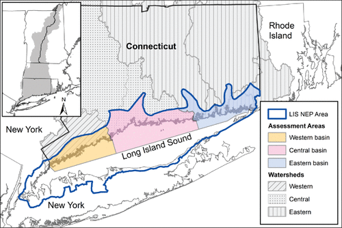
LIS is one of the 28 estuaries designated as nationally significant under the U.S. Environmental Protection Agency (USEPA) National Estuary Program (NEP). The habitat condition assessment presented herein was completed in the Connecticut portion of the LIS NEP (). NEPs provide ideal locations to implement landscape-scale assessments because they are dedicated to improving and monitoring overall habitat health. NEPs support development and implementation of locally based Comprehensive Conservation and Management Plans (CCMPs). The LIS CCMP (Long Island Sound Study Citation2015) identifies specific ecosystem recovery targets and recommends developing an index of current overall habitat condition. This index would establish a baseline condition and make it more feasible to track the effectiveness of restoration toward achieving specific ecosystem recovery targets.
Although the LIS CCMP lays out these recommendations, a gap exists at both the local and national levels. Nationally, a coastal condition report (USEPA Citation2012) and a coastal wetland assessment are complete (Dahl and Stedman Citation2013), however neither addresses the suite of coastal habitats that affect overall estuary health. Additionally, few comprehensive health assessments exist at the local NEP level. For example, the EcoHealth Report Card for the LIS includes a health score that is solely reflective of water quality and does not include an assessment of LIS's priority terrestrial or aquatic habitats (Save the Sound Citation2016).
To address this gap, we first developed a landscape-scale framework for assessing priority coastal (terrestrial and aquatic) habitats of LIS NEP. Second, we completed an assessment of the overall health of the LIS NEP. Third, we reviewed the state of landscape-scale assessments within five other coastal programs – LIS NEP, Narragansett Bay NEP, San Francisco Estuary NEP, Tampa Bay NEP, and the Chesapeake Bay Program. Last, we offer recommendations on how the landscape-scale assessment framework developed here could be applied elsewhere to establish a baseline condition, facilitate strategic goal setting, and help assess progress toward achieving desired outcomes.
Methods
Habitat assessment framework
To develop the habitat assessment framework, we assembled a diverse panel of coastal habitat experts from state, federal, nonprofit, and academic institutions. They focused on priority habitats selected by the LIS NEP (Latimer et al. Citation2014; Long Island Sound Study Citation2014). The panel included all Long Island Sound priority habitats for which 3 or more metrics could be established using currently available data (). In identifying metrics, or indicators of health, the panel used best available information, professional judgment, and peer-reviewed literature ().
Table 1. LIS priority habitats included in this assessment.
The panel considered three factors in defining habitat health: (1) ecological integrity of the habitat (habitat structure and function), (2) resilience to stress (ability to recover from disturbance), and (3) ability to provide services (e.g. provide habitat, filter pollutants) (Boulton Citation1999; Folke et al. Citation2004; Karr Citation1996). Karr et al. (Citation1986) states, “a biological system … can be considered healthy when its inherent potential is realized, its condition is stable, its capacity for self-repair when perturbed is preserved, and minimal external support for management is needed.” As the field of ecology advances, ecological health is viewed as a range of acceptable conditions rather than a static point, with the goal of shifting ecosystem composition, structure, and function into a range that is more desirable than the current degraded state (Palmer Citation2008; Duarte et al. Citation2009). To make the framework and assessment broadly applicable, the panel identified metrics that are capable of highlighting habitat condition, applicable to a wide range of systems, and cost effective to measure and monitor (Boulton Citation1999; Karr Citation1991; Niemeijer and Groot Citation2008).
Habitat assessment
The LIS NEP is divided into three geographic basins for the purposes of management and communication (). The basins differ across factors including human density, water quality, current, and sediment size (Long Island Sound Study Citation2015). Using the framework, priority habitat types were assessed in these three basins with associated watersheds to maintain consistency with other LIS publications and management activities.
Figure 1. LIS basins used for habitat status analysis.
Data pertaining to each metric for each priority habitat were compiled from existing data sources and analyzed using The Nature Conservancy's open source Miradi software indicator monitoring component (Benetech Citation2008). In order to derive a habitat score, a data point for each metric within each priority habitat was mathematically re-indexed using value ranges unique to that metric. These value ranges are habitat condition “cut-points” and are defined in for each metric. The re-indexing generated a value that was assigned to one of the following bins: poor (0–25), fair (25–50), good (50–75), and very good (75–100). This allowed a standardized means of analyzing metrics with varying units and ranges of habitat condition. Each metric was then weighted based on its contribution to the overall habitat condition of each priority habitat type. Classification cut points and weighting were set specifically for the Long Island Sound ecosystem. The ranges and weightings can be adjusted to best suit the local ecosystem where the framework is applied.
Table 2. Eelgrass habitat assessment metrics. Density and Bed Size Metric corresponds to eelgrass surveys in LIS as: VERY LOW = low; LOW = lower half of medium, MEDIUM = upper half of medium, HIGH = high (MacLachlan Citation2014; Tiner, McGuckin, and MacLachlan Citation2013).
Table 3. Embayment habitat assessment metrics. All data came from a rapid assessment of embayments conducted in late summer, 2011-2013; and are thus directly comparable among all sites (Vaudrey Citation2015; Vaudrey et al. Citation2013b).
Table 4. Tidal wetland habitat assessment metrics.
Table 5. Riverine migratory corridor (RMC) assessment metrics.
Table 6. Coastal forest habitat assessment metrics. All metrics used 2010 UConn CLEAR land cover data, 30 m resolution (CLEAR Citation2012). Fragmentation was determined using the UConn CLEAR Landscape Fragmentation Tool (CLEAR Citation2007). Only forests within the defined coastal boundary were assessed.
Programmatic review of landscape-scale assessments
A review was conducted of five leading national estuary and coastal programs in order to assess the status and application of landscape-scale assessment frameworks like the one developed in this study. The review consisted of conversations with program staff and a review of published literature and other publically available information for each program, including program websites and CCMPs. Because the purpose was to assess publicly available information, anecdotal and non-published data are not included. Specific focus was given to the main website for each program, as that is the location the public likely would check first for habitat health information.
Results
Habitat assessment framework
The metrics indicating health for each priority habitat type, along with a description, classification cut-points (e.g., the range of values that comprise poor, fair, good, and very good), and metric weighting are presented in . In the sections below, we provide a description of the metrics selected as indicators of habitat health.
Eelgrass
Eelgrass metrics were selected based on common methods for measuring eelgrass health in LIS and other estuaries (Hauxwell, Cebrián, and Valiela Citation2003; Tiner, McGuckin, and Herman Citation2013). Reduction in density and bed size, colonization area, and amount of light reaching the blades can all negatively affect eelgrass habitat (Hauxwell, Cebrián, and Valiela Citation2003). As such, the metrics selected for the LIS NEP include density (# of stems/m2) and bed size (m2), change in overall area (m2) relative to a previous timeframe, and degree of colonization of epiphytes and epifauna. The density of eelgrass beds in the LIS NEP depends, in part, on light. Eelgrass beds receiving more light have up to 1,200 shoots/m2 while beds with low light have <50 shoots/m2 (Krause-Jensen et al. Citation2000). Similarly, epiphyte coverage hinders eelgrass success by blocking light to shoots (Brush and Nixon Citation2002). In extreme cases, epiphytes in LIS completely cover and weigh down shoots.
Embayments
The metrics selected as indictors of embayment health are broadly recognized as indicators of decline in water quality and embayment health across the country (Bricker et al. Citation2007; USEPA Citation2012). Chlorophyll A and macroalgae are early indicators of increased nutrient concentrations. Dissolved oxygen and loss of eelgrass are secondary symptoms of more serious eutrophication problems. In LIS, decline in eelgrass is linked to nitrogen enrichment (Bricker et al. Citation2007).
Tidal wetlands
The metrics chosen as indicators of tidal wetland health reflect the major symptoms of stressed marshes. Open water on the marsh was assigned the greatest weight. Saltwater intrusion was the leading cause of coastal wetland loss in the last two national assessments of wetland condition (Dahl and Stedman Citation2013). Open water can lead to loss of vegetated marsh (Kirwan et al. Citation2010; Tiner, McGuckin, and Herman Citation2013) indicating submergence and potentially a regime shift (Folke et al. Citation2004; Roman Citation2017). Open water ranges and cut-points follow recommendations for New England marshes, with “very good” aligning with the average amount of permanent open water at ≤9% of an unditched New England marsh (Adamowicz and Roman Citation2005). Impervious cover (IC) surrounding the marsh is linked to marsh impairment (Arnold and Gibbons Citation1996; Schueler Citation2003). IC thresholds for rivers, discussed below, also apply to wetlands (Arnold and Gibbons Citation1996) and were used to guide the development of the IC metric. Size was included as an indicator because coastal systems that are larger in size and less fragmented are better able to recover from disturbance and support more biologically diverse communities than smaller, more fragmented habitats (Meiman et al. Citation2012; Thrush et al. Citation2008).
Riverine migratory corridors
For the RMC assessment, connectivity was assigned the greatest weight. Decreased connectivity alters a central RMC function, serving as a thoroughfare for diadromous fish to migrate and spawn (Pringle Citation2003). The other two metrics, water quality and IC, are common indicators used to assess river health (Schueler, Fraley-McNeal, and Cappiella Citation2009). Surrounding IC is linked to RMC impairment (Arnold and Gibbons Citation1996; May et al. Citation1997; Schueler, Fraley-McNeal, and Cappiella Citation2009). In Connecticut, the least disturbed streams are in areas with less than 4% IC in the upstream watershed; 8% IC begins to negatively affect rivers; at 12% IC rivers no longer support aquatic life goals (Bellucci, Becker, and Beauchene Citation2011). Other work corroborates these cut-offs and indicates significant impairment starts at approximately 10% IC (Arnold and Gibbons Citation1996; May et al. Citation1997).
Coastal forests
Indicators selected to measure coastal forest health include size, connectivity, and fragmentation. Changes in these metrics can affect overall forest health and composition of species like forest interior birds (Tischendorf and Fahrig Citation2000; Thompson et al. Citation2009; Askins, Philbrick, and Sugeno Citation1987). For example, a steep drop in forest interior bird species diversity occurs in forest blocks smaller than about 125 acres (0.5 km2)(Askins, Philbrick, and Sugeno Citation1987). In the framework, the connectivity metric indicates the fraction of forest perimeter adjacent to developed land. The fragmentation metric reflects forest block shape and uses the UConn CLEAR Landscape Fragmentation Tool. Fragmentation cut-points were set based on expert insight. In Connecticut, forest fragmentation is typically low when total core forest coverage is ≥70%. Fragmentation starts when cover is <70% (Askins Citation2014).
Habitat assessment application
This assessment is the first, landscape-scale study of habitat health across multiple priority habitat types in the LIS NEP. Overall, the LIS NEP ranked fair for the habitats assessed (27 out of 100 points). Considering the LIS as a whole, tidal wetlands, eelgrass, and coastal forests are in poor condition. Embayments and RMC are in fair condition ().
Figure 2. LIS priority habitat health. Habitat scores are out of 100. Colors denote indicator score using evaluation criteria in –. Red is poor, yellow is fair, light green is good, and dark green is very good. Pie chart areas represent weighting applied to indicators when calculating the basin scores.
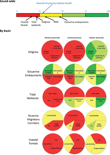
Habitat health was also assessed by basin. The three LIS basins are a common way of referring to geographic areas of the LIS NEP. Moving from the western to the eastern basin, population density, nutrient loads, and IC generally decrease and tidal flushing increases (Long Island Sound Study Citation2015). These factors may contribute to the differences in health across the basins. All priority habitats assessed are in poor condition in both the western and central basins, with the exception of estuarine embayments, which are in fair condition in the western and central basins. Across the five habitats assessed in both western and central basins, eelgrass has the lowest health ranking followed next by wetlands and forests. In the eastern basin, wetlands, rivers, and forest are in fair condition and eelgrass and embayments are in good condition. Across the five habitats assessed in the eastern basin, forests have the lowest health ranking followed next by wetlands. In addition to the biotic and abiotic differences between these basins, better health rankings for embayments may be due to a large focus on water quality improvements.
The assessment can also be looked at by metric. A total of 16 metrics were used in this study. In the western basin, 14 out of 16 metrics fall into the poor category for the habitats they measure. In the central basin, 9 of the 16 metrics fall into the poor category and in the eastern basin, only 2 of the 16 metrics fall into the poor category (). The metrics appear to be responding, at least in part, to varying levels of development pressure, which is highest in the western basin. As development pressures lessen moving west to east, more metrics fall in the fair, good, and very good categories.
Habitat assessment review
The majority of other coastal programs that we reviewed track geographic extent for most of their priority habitats. Some programs provide a rank for habitat health based solely on geographic extent. Some programs use multiple indicators, but do not synthesize this information into a habitat health rank. In addition to this study, San Francisco Bay and Chesapeake Bay use a multi-indicator approach and provide health rankings for selected priority habitats. Tampa Bay uses a multi-indicator approach for eelgrass. None of the programs reviewed use multiple indicators to comprehensively rank habitat health across all of their priority habitat types. Across all programs grasslands and freshwater wetlands have the least-developed health assessments, although most programs indicate the importance of these habitats to overall coastal ecosystem health ().
The status and condition of priority habitats within the programs assessed was largely unclear. Programs either lacked the data needed for comprehensive habitat health assessments or had the data but did not integrate it to produce information on overall habitat health.
Discussion
The main objectives of this study were to (1) develop a habitat assessment framework, (2) apply the framework to assess priority habitat types within the LIS NEP, and (3) review the state of habitat assessments across other coastal programs.
Habitat assessment framework
The assessment framework developed herein captures priority habitat types that support diverse, structurally sound communities, provide important ecosystem services, and have significant economic value. The selected metrics measure the stressors on the landscape that affect the health of each habitat type, and in turn, the overall health of the LIS. While there may be no perfect set of metrics, size, habitat connectivity, natural flow, and structural soundness are four central factors related to coastal habitat health. The selected metrics capture these four factors. Coastal habitats of larger sizes are often better able to withstand disturbance and support more diverse communities (Meiman et al. Citation2012; Thompson et al. Citation2009; Reed and Hovel Citation2006). Habitats that are connected are better able to support species movement, genetic diversity, and species' ability to cope with stress (McGuire et al. Citation2016; Neraas and Spruell Citation2001). Natural flow of river and tidal waters provide numerous habitat health-related benefits including sediment transport, temperature control, and nutrient dilution which improves water quality and helps keep epiphytes under control (Mann Citation1982; Bednarek Citation2001; Hemminga and Duarte Citation2000). The final major factor contributing to habitat health and resilience relates to structural soundness of communities. Structurally sound communities exhibit the species distribution and diversity expected in an undisturbed habitat. Structural soundness is influenced by factors like size, connectivity, flow, and water quality. Examples of metrics that indicate problems with structure are excessive epifauna on eelgrass, nuisance macroalgae blooms in any of the aquatic habitats, invasive species replacing natural communities, fragmentation, and open water on tidal marshes.
Habitat assessment application and landscape-scale assessments within other coastal programs
Present day stressors on coastal habitats are complex, interconnected, and nuanced (Silliman, Grosholz, and Bertness Citation2009). Additionally, restoration is not as effective as it could be. This is due in part to vague, non-scientific goals, and attachment to a static, prior condition (Duarte et al. Citation2009; Palmer Citation2008; Greening et al. Citation2014). A holistic approach focused on restoring functional integrity of ecosystems so that they can sustain benefits to society could be more effective (Duarte et al. Citation2009).
Applying the assessment to the LIS sheds new light on the status of habitat health in the Sound. This assessment creates a starting point, whereby managers can quantitatively discuss, set, and track improvements. Programs can use the habitat assessment framework we developed to (1) set function-based, ecologically informed goals, (2) link on-the-ground projects to goals, (3) use historic data to inform goals, and (4) implement broad landscape-scale assessments to measure progress toward desired outcomes.
Set function-based, ecologically informed goals
Habitat goals in some NEPs are set on size parameters and what was achieved in the past, rather than multiple ecological indicators or science. Programs and policies focus on protecting “resilience and function” of habitats, but these terms are often ambiguous and undefined (Long Island Sound Study Citation2016). This assessment could help coastal programs understand the ecological impact of current goals, define resiliency and function, and set goals based on what needs to be accomplished to maintain a desired level of habitat function and value. The LIS CCMP provides an example: under the current RMC goal (open 200 miles in 20 years), the RMC connectivity score will be about the same as it is today, remaining in fair and poor categories. Applying this assessment, “open 200 miles in 20 years,” could become, “Within the next 10 years, river connectivity is restored so that 70% of all available RMC miles are open to diadromous fish, a 34% improvement in connectivity from the 2015 baseline. Water quality is improved to fair condition in the western and central basins and to good condition in the eastern basin and there is no net increase in impervious cover in any basin.” In practice, focus should fall on moving habitats toward an acceptable “range” relative to a less disturbed state (Palmer Citation2008). This assessment provides the language and tools by which to set this range and track progress in a measurable way.
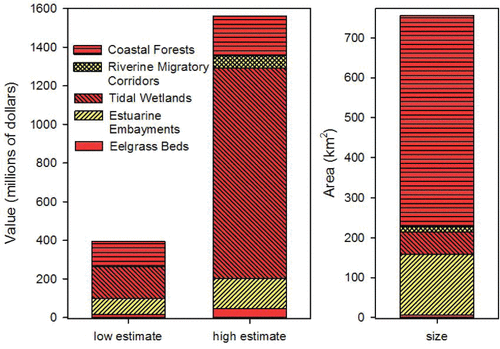
In setting function-based goals, it may be useful to integrate an economic lens. Making a link between habitat quality and economic value can help focus restoration and protection priorities. For example, while coastal forests and embayments currently occupy more total area (), the greater per acre value of tidal wetlands yields 42 to 70% of the total economic value of the five assessed habitats. Coastal forests account for 13 to 33% of the total economic value and embayments account for 10 to 21%. Due to the smaller area of eelgrass and RMC, their economic contribution is substantially lower. While ecological links between these habitats suggest that all should be addressed in a comprehensive manner, focus should fall on tidal wetlands as a top priority when considering economic value.
Figure 3. Comparison of habitat quality with economic valuation. Total value of habitats for the low and high per acre estimate () illustrate the relative estimated value of habitats in LIS. Area of each type is presented for comparison. Red indicates poor habitat quality and yellow indicates fair habitat quality as presented in .
Link goals across habitat types
Linking goals across habitat types enables managers to create policies and programs that are in line with how habitats function within ecosystems, as interconnected pieces rather than independent entities. However, ecosystems and response times are complex (Duarte et al. Citation2009), so linking goals should not imply a linear relationship.
To fully implement linked goals, quantitative tools are needed. This study provides one possible tool to more holistically address health across habitat types. For example, tidal restrictions like dams can impact rivers, wetlands, and embayments and negatively impact wildlife (Bednarek Citation2001; Correll Citation2016). Dams can limit sediment supply, affecting the resilience of sediment-limited salt marshes (Correll Citation2016). Dams can also cause poor water quality due to lack of flow, which in turn exacerbates thermal stress, hypoxia, and impacts eelgrass health (Bednarek Citation2001; Hemminga and Duarte Citation2000). Linking goals can forward an ecosystem services perspective. As discussed above, improving health in one area (dams/connectivity) can affect multiple habitats. And healthier habitats provide more ecosystem service benefits (Barbier et al. Citation2010).
Approaching the results of the assessment from an ecosystem service angle could help gain community and political support. We developed as a starting point for efforts to maintain ecosystem services by improving factors that contribute to habitat health across all priority habitat types.
Table 7. Landscape-level assessments in select coastal programs. white = no habitat extent data found, grey = existing or restored habitat extent tracked; M = multiple indicators tracked; H = multi indicator assessment synthesized into a habitat health rank; N/A = not applicable (ecologically relevant) based LIS habitat definitions.
Table 8. Services, resilience, and value of LIS habitats. Column A includes major contributors to habitat resilience (bold = factors that contribute to habitat resilience in the face of climate change). Column C provides the health status, economic value, current extent, and estimated value to LIS.
Use historic data to inform goals and communicate change in health
Historic change can provide important reference points for restoration (Lotze et al. Citation2006). Tampa Bay and San Francisco Bay provide compelling examples of leveraging an understanding of historic change to advance meaningful improvement on an ecosystem scale. Over 20 years ago, Tampa Bay managers set an ambitious goal to restore seagrass to 1950 acreage levels, ∼38,000 total acres (153.8 km2), requiring restoration of 13,000 acres (52.6 km2). Tampa Bay exceeded their restoration goal, with current seagrass extent at 41,655 total acres (169 km2) (Cicchetti and Greening Citation2011; Sherwood et al. Citation2017). Similarly, San Francisco Bay showed impressive restoration gains even under intense urban pressure. Managers used a historic context coupled with an understanding of habitat health to reset assumptions on the scale of wetland restoration needed (Goals Project Citation1999). Using historic reference points to contextualize restoration goals can advance progress on more ecologically meaningful levels (Goals Project Citation2015).
Create broader landscape-scale assessments
Landscape-scale assessments could encourage programs in the same region to track and communicate ecosystem health in a similar way. One of the downfalls of restoration projects is that they are often too small to be meaningful. Even so called “landscape-scale” projects are often disjointed efforts by multiple partners who work on their own piece and track progress using their own databases, rather than coordinate (Palmer Citation2008).
While few of the coastal programs reviewed conduct integrated health assessments, many have the data needed to do it. The indicators presented here allow each program to decide cut-points for their specific location. Thus, outputs can be tailored to local systems and compared cross-programmatically using common terminology. Setting goals across regions can be more economical, bring greater ecological benefit (Neeson et al. Citation2015), and encourage healthy cooperation and competition between programs in similar ecoregions.
Conclusion
Although large amounts of money and time are spent on restoration efforts, losses may be outpacing gains (USEPA Citation2017; Palmer Citation2008). However, success stories do exist. For example, programs in the Chesapeake, Tampa, and San Francisco Bays (USA) show habitat restoration success through health-orientated goal setting. Currently, coastal habitat restoration progress is limited to select locations and habitats. More could be done.
The results of this study and the efforts of other programs highlight the importance of moving away from vague goals, disjointed small-scale projects, and a significant, but limited focus on nutrient inputs. This effort shows that the development of a framework to assess coastal habitat condition is possible for the LIS NEP and for other coastal programs. The framework developed herein enables the quantitative assessment of current priority habitat condition in the LIS NEP and it establishes a baseline. This in turn affords the opportunity to develop science-based, data driven restoration goals. Broader ecosystem health goals can now be used to steer formerly disconnected restoration efforts across the LIS NEP, and progress toward these goals can be tracked. Quantitative, landscape-scale frameworks are timely and can be leveraged to improve restoration success across coastal ecosystems.
Acknowledgments
We thank Susan Adamowicz, Robert Askins, Paul Capotosto, Patrick Comins, Chris Elphick, Charles Frost, Steve Gephard, Sally Harold, Troy Hill, Jeff Horan, Andrew MacLachlan, Victoria O'Neill, Suzanne Paton, Larry Swanson, Roger Wolfe and Harry Yamalis for providing data, field assistance, technical expertise and invaluable discussions that improved this publication. We thank Mark Tedesco and Holly Drinkuth for overall guidance. We thank Holly Greening and Letitia Grenier for their insight. We thank Mark Brouder and Peg Van Patten for critical reviews and John Fisher and Ana Herrera for reference material. Special thanks to David Robinson who supported this effort.
Funding
This project was funded in part by the Interagency Agreement between USEPA and USFWS and by USEPA to the Sponsored Program Services of the University of Connecticut on behalf of Connecticut Sea Grant, and in collaboration with New York Sea Grant (awards LI96144301 and LI96113701).
References
- Adamowicz, S. C., and C. T. Roman. 2005. New England salt marsh pools: A quantitative analysis of geomorphic and geographic features. Wetlands 25 (2):279–88. doi:10.1672/4.
- Arnold, C. L. Jr., and C. J. Gibbons. 1996. Impervious surface coverage the emergence of a key environmental indicator. Journal of the American Planning Association 62 (2):243–58. doi:10.1080/01944369608975688.
- Askins, R. A. 2014. Personal communication. New London, CT: Connecticut College.
- Askins, R. A., M. J. Philbrick, and D. S. Sugeno. 1987. Relationship between the regional abundance of forest and the composition of forest bird communities. Biological Conservation 39 (2):129–52. doi:10.1016/0006-3207(87)90030-9.
- Barbier, E. B., S. D. Hacker, C. Kennedy, E. W. Koch, A. C. Stier, and B. R. Silliman. 2010. The value of estuarine and coastal ecosystem services. Ecological Monographs 81 (2):169–93. doi:10.1890/10-1510.1.
- Basso, G., K. O'Brien, M. Albino, and V. O'Neill. 2015. Status and trends of wetlands in the Long Island Sound Area: 130 year assessment. U.S. Department of the Interior, Fish and Wildlife Service. 37 pp. Accessed January 28, 2015. http://www.fws.gov/northeast/science/sciencenews/wetlandslongislandsound.html.
- Bednarek, A. 2001. Undamming rivers: A review of the ecological impacts of dam removal. Environmental Management 27 (6):803–14. doi:10.1007/s002670010189.
- Bellucci, C. J., M. Becker, and M. Beauchene. 2011. Characteristics of macroinvertebrate and fish communities from 30 least disturbed small streams in Connecticut. Northeastern Naturalist 18 (4):411–44. doi:10.1656/045.018.0402.
- Benetech. 2008. Miradi – adaptive management software for conservation projects. Foundations of Success. Accessed January 28, 2015. https://miradi.org/.
- Boulton, A. J. 1999. An overview of river health assessment: Philosophies, practice, problems and prognosis. Freshwater Biology 41 (2):469–79. doi:10.1046/j.1365-2427.1999.00443.x.
- Bricker, S., B. J. Longstaff, W. Dennison, A. Jones, K. Boicourt, C. Wicks, and J. Woerner. 2007. Effects of nutrient enrichment in the nation's estuaries: A decade of change. NOAA Coastal Ocean Program Decision Analysis Series No. 26. National Centers for Coastal Ocean Science, Silver Spring, MD. 328 pp. Accessed January 28, 2015. http://eutro.org.
- Bricker, S. B., J. G. Ferreira, and T. Simas. 2003. An integrated methodology for assessment of estuarine trophic status. Ecological Modelling 169 (2003):39–60. doi:10.1016/S0304-3800(03)00199-6.
- Brush, M. J., and S. W. Nixon. 2002. Direct measurements of light attenuation by epiphytes on eelgrass Zostera marina. Marine Ecology Progress Series 238:73–9. doi:10.3354/meps238073.
- Chesapeake Bay Foundation. 2016. State of the Bay. 20 pp. Accessed March 2, 2017. http://www.cbf.org/about-the-bay/state-of-the-bay-report-2016.
- Cicchetti, G., and H. Greening. 2011. Estuarine biotope mosaics and habitat management goals: An application in Tampa Bay, FL, USA. Estuaries and Coasts 34 (6):1278–92. doi:10.1007/s12237-011-9408-4.
- CLEAR. 2007. Landscape Fragmentation Tool, LFT v2.0. Storrs, CT: Center for Land Use Education And Research (CLEAR) The University of Connecticut Department of Agriculture. version 2.0. Accessed August 5, 2015. http://clear.uconn.edu/tools/lft/lft2/index.htm.
- CLEAR. 2012. 2010 Land Cover, area_2010_v2-03.img. Storrs, CT: Center for Land Use Education And Research (CLEAR) The University of Connecticut Department of Agriculture. Series: Long Island Sound Watershed's Changing Landscape, version 2.03. Accessed August 5, 2015. http://clear.uconn.edu/projects/landscapelis/downloadLIS.asp.
- Correll, M. D., W. A Wiest, T. P. Hodgman, W. G. Shriver, C. S. Elphick, B. J. McGill, K. M. O'Brien, and B. J. Olsen. 2016. Predictors of specialist avifaunal decline in coastal marshes. Conservation Biology 00(0):1–11.
- Dahl, T.E., and S.M. Stedman. 2013. Status and trends of wetlands in the coastal watersheds of the conterminous United States 2004 to 2009. U.S. Department of the Interior, Fish and Wildlife Service and National Oceanic and Atmospheric Administration, National Marine Fisheries Service. 46 pp.
- Duarte C., D. J. Conley, J., Carstensen, and M. Sánchez-Camacho. 2009. Return to Neverland: Shifting baselines affect eutrophication restoration targets. Estuaries and Coasts 32 (1):29–36. doi:10.1007/s12237-008-9111-2.
- Folke, C., S. Carpenter, B. Walker, M. Scheffer, T. Elmqvist, L. Gunderson, and C. S. Holling. 2004. Regime shifts, resilience, and biodiversity in ecosystem management. Annual Review of Ecology, Evolution, and Systematics 35:557–81.
- Gedan, K.B., B.R. Silliman, and M.D. Bertness. 2009. Centuries of human-driven change in salt marsh ecosystems. Annual Review of Marine Science 1 (1):117–41. doi:10.1146/annurev.marine.010908.163930.
- Goals Project. 1999. Baylands ecosystem habitat goals. A report of habitat recommendations prepared by the San Francisco Bay Area Wetlands Ecosystem Goals Project: U.S. Environmental Protection Agency, San Francisco, CA/S.F. Bay Regional Water Quality Control Board, Oakland, CA. 328 pp.
- Goals Project. 2015. The Baylands and climate change: What we can do. Baylands ecosystem habitat goals science update 2015. Prepared by the San Francisco Bay Area Wetlands Ecosystem Goals Project. California State Coastal Conservancy, Oakland, CA. 237 pp.
- Greening, H., A. Janicki, E. T. Sherwood, R. Pribble, and J. O. R. Johansson. 2014. Ecosystem responses to long-term nutrient management in an urban estuary: Tampa Bay, Florida, USA. Estuarine, Coastal and Shelf Science 151:A1–A16. doi:10.1016/j.ecss.2014.10.003.
- Hemminga, M. A., and C. M. Duarte. 2000. Seagrass ecology. Cambridge, U.K: Cambridge University Press, pp. 312.
- Hauxwell, J., J. Cebrián, and I. Valiela. 2003. Eelgrass Zostera marina loss in temperate estuaries: relationship to land-derived nitrogen loads and effect of light limitation imposed by algae. Marine Ecology Progress Series 247:59–73. doi:10.3354/meps247059.
- Karr, J. R., K. D. Fausch, P. L. Angermeier, P. R. Yant, and I. J. Schlosser. 1986. Assessing biological integrity in running waters: A method and its rationale. Special Publication 5. Illinois Natural History Survey, Champaigne, Illinois. 31 pp.
- Karr, J. R. 1991. Biological integrity: A long-neglected aspect of water resource management. Ecological Applications, Ecological Society of America 1 (1):66–84. doi:10.2307/1941848.
- Karr, J. R. 1996. Ecological integrity and ecological health are not the same. In Engineering within ecological constraints, ed. P. C. Schulze, 97–109. Washington DC: National Academy Press.
- Kirwan, M. L., G. R. Guntenspergen, A. D'Alpaos, J. T. Morris, S. M. Mudd, and S. Temmerman. 2010. Limits on the adaptability of coastal marshes to rising sea level. Geophysical Research Letters 37 (23):1–5. doi:10.1029/2010GL045489.
- Kocian, M., A. Fletcher, G. Schundler, D. Batker, A. Schwartz, and T. Briceno. 2015. The trillion dollar asset: The economic value of the Long Island Sound basin. Earth Economics, Tacoma, WA. 84 pp. Accessed May 14, 2015. http://www.eartheconomics.org/FileLibrary/file/Reports/Earth%20Economics%20Long%20Island%20Sound%20Basin%202015%20Final%20Report.pdf.
- Krause-Jensen, D., A. L. Middelboe, K. Sand-Jensen, and P. B. Christensen. 2000. Eelgrass, Zostera marina, growth along depth gradients: Upper boundaries of the variation as a powerful predictive tool. Oikos 91 (2):233–44. doi:10.1034/j.1600-0706.2001.910204.x.
- Latimer, J. S., M. A. Tedesco, R. L. Swanson, C. Yarish, P. E. Stacey, and C. Garza eds. 2014. Long Island Sound: Prospects for the Urban Sea. NY: Springer Publishers.
- Long Island Sound Study. 2014. 12 Priority Habitat Types. Long Island Sound Study. Accessed May 21, 2015. http://longislandsoundstudy.net/issues-actions/habitat-quality/important-coastal-habitat-types/.
- Long Island Sound Study. 2015. Long Island Sound Comprehensive Conservation and Management Plan 2015: Returning the urban sea to abundance. 76 pp. Accessed June 1, 2016. http://longislandsoundstudy.net/wp-content/uploads/2015/09/CCMP_LowRes_Hyperlink_singles.pdf.
- Long Island Sound Study. 2016. Futures Fund Request for Proposals. Long Island Sound Study. Accessed June 1, 2016. http://www.nfwf.org/lisff/Pages/2016lisffrfp.aspx.
- Long Island Sound Study. 2017. Status & Trends: Long Island Sound Study Environmental Indicators. Accessed March 2, 2017. http://longislandsoundstudy.net/research-monitoring/long-island-sound-environmental-indicators/.
- Lotze, H. K., H. S. Lenihan, B. J. Bourque, R. H. Bradbury, R. G. Cooke, M. C. Kay, S. M. Kidwell, M. X. Kirby, C. H. Peterson, and J. B. C. Jackson. 2006. Depletion degradation, and recovery potential of estuaries and coastal seas. Science 312 (5781):1806–9. doi:10.1126/science.1128035.
- MacLachlan, A. 2014. Personal communication. Southern New England – New York Bight Coastal Program, Charlestown, RI. [email protected].
- Mann, K. H. 1982. Ecology of coastal waters: A systems approach. Berkeley, CA: University of California Press, pp. 332.
- May, C. W., R. R. Horner, J. R. Karr, B. W. Mar, and E. B. Welch. 1997. Effects of urbanization on small streams in the Puget Sound Lowland Ecoregion. Watershed Protection Techniques 2 (4):483–94.
- Meiman, S., D. Civco, K. Holsinger, and C. S. Elphick. 2012. Comparing habitat models using ground-based and remote sensing data: Saltmarsh sparrow presence versus nesting. Wetlands 32 (4):725–36. doi:10.1007/s13157-012-0306-8.
- McGuire, J. L., J. J. Lawler, B. H. McRae, T. A. Nuñez, and D. M. Theobald. 2016. Achieving climate connectivity in a fragmented landscape. Proceedings of the National Academy of Sciences 113 (26):7195–200. doi:10.1073/pnas.1602817113.
- Narragansett Bay Estuary Program. 2017. State of the Bay and Its Watershed 500 pp. Accessed July 27, 2017. http://nbep.org/the-state-of-our-watershed/technicalreport/.
- Neeson, T. M., M. C. Ferris, M. W. Diebel, P. J. Doran, J. R. O'Hanley, and P. B. McIntyre. 2015. Enhancing ecosystem restoration efficiency through spatial and temporal coordination. Proceedings of the National Academy of Sciences of the United States of America 112 (19):6236–41. doi:10.1073/pnas.1423812112.
- Nellemann, C., E. Corcoran, C. M. Duarte, L. Valdés, C. D. Young, L. Fonseca, and G. Grimsditch eds. 2009. Blue Carbon: A rapid response assessment. United Nations Environment Programme, GRID-Arendal. 80 pp. Accessed January 28, 2015. http://www.grida.no/publications/rr/blue-carbon/.
- Neraas, L. P. and P. Spruell. 2001. Fragmentation of riverine systems: The genetic effects of dams on bull trout (Salvelinus confulentus) in the Clark Fork River system. Molecular Ecology 10:1153–64. doi:10.1046/j.1365-294X.2001.01269.x.
- Niemeijer, D., and R. S. Groot. 2008. A conceptual framework for selecting environmental indicator sets. Ecological Indicators 8:14–25. doi:10.1016/j.ecolind.2006.11.012.
- Palmer, M. A. 2008. Reforming watershed restoration: Science in need of application and applications in need of science. Estuaries and Coasts 32 (1):1559–2723.
- Pringle, C. 2003. What is hydrologic connectivity and why is it ecologically important? Hydrological Processes 17 (13):2685–9. doi:10.1002/hyp.5145.
- Reed, B. J., and K. A. Hovel. 2006. Seagrass habitat disturbance: How loss and fragmentation of eelgrass Zostera marina influences epifaunal abundance and diversity. Marine Ecology Progress Series 326:133–43. doi:10.3354/meps326133.
- Roman, C. 2017. Salt marsh sustainability: Challenges during an uncertain future. Estuaries and Coasts, 40 (3):711–16.
- San Francisco Estuary Partnership. 2015. State of the Estuary Report. 96 pp. Accessed March 2, 2017. http://www.sfestuary.org/about-the-estuary/soter/.
- Save the Sound. 2016. Long Island Sound Report Card 2016. Accessed August 21, 2017. http://ian.umces.edu/pdfs/ian_newsletter_541.pdf.
- Schueler, T. R. 2003. Impacts of impervious cover on aquatic systems. Watershed protection research monograph 1:1–158.
- Schueler, T., L. Fraley-McNeal, and K. Cappiella. 2009. Is impervious cover still important? Review of recent research. Journal of Hydrologic Engineering 14 (4):309–15. doi:10.1061/(ASCE)1084-0699(2009)14:4(309).
- Sherwood, E. T., H. S. Greening, A. J. Janicki, and D. J. Karlen. 2016. Tampa Bay Estuary: Monitoring long-term recovery through regional partnerships. Regional Studies in Marine Science 4:1–11. doi:10.1016/j.rsma.2015.05.005.
- Sherwood, E. T., H. S. Greening, J. O. R. Johansson, K. Kaufman, and G. E. Raulerson. 2017. Tampa Bay (Florida, USA): Documenting seagrass recovery since the 1980's and reviewing the benefits. Southern Geographer. 57 (3):294–319. doi:10.1353/sgo.2017.0026.
- Silliman, B. R., E. D. Grosholz, and M. D. Bertness, eds. 2009. Human impacts on salt marshes: A global perspective. Berkeley, CA: University of California Press.
- Tampa Bay Estuary Program. 2015. Progress Report. 20 pp. Accessed March 2, 2017. http://www.tbep.org/pdfs/tbep_progress_rpt_2015_webx.pdf.
- Thompson, I., B. Mackey, S. McNulty, and A. F. R. Mosseler. 2009. Forest Resilience, Biodiversity, and Climate Change. Technical Series no. 43. Secretariat of the Convention on Biological Diversity, Montreal, Canada. 67 pp.
- Thrush, S., J. Halliday, J. Hewitt, and A. Lohrer. 2008. The effects of habitat loss, fragmentation, and community homogenization on resilence in estuaries. Ecological Applications 18 (1):12–21. doi:10.1890/07-0436.1.
- Tiner, R., K. McGuckin, and J. Herman. 2013. Changes in Connecticut wetlands: 1990 to 2010. U.S. Fish and Wildlife Service, Northeast Region, Hadley, MA. 36 pp. Accessed January 28, 2015. http://www.ct.gov/deep/lib/deep/water_inland/wetlands/connecticut_wetld_trends_1990-2010_final_report_2013.pdf.
- Tiner, R., K. McGuckin, and A. MacLachlan. 2013. 2012 Eelgrass survey for Eastern Long Island Sound, Connecticut and New York. U.S. Fish and Wildlife Service, National Wetlands Inventory Program, Northeast Region, Hadley MA. 26 pp. Accessed January 28, 2015. http://longislandsoundstudy.net/wp-content/uploads/2013/11/2012-LIS-Eelgrass-Final.Report_11-26-2013.pdf.
- Tischendorf, L., and L. Fahrig. 2000. On the usage and measurement of landscape connectivity. Oikos 90 (1):7–19. doi:10.1034/j.1600-0706.2000.900102.x.
- USEPA. 2012. National Coastal Condition Report IV, Report: EPA-842-R-10-003. Office of Research and Development/Office of Water, Washington, DC. 298 pp. Accessed August 21, 2017. http://water.epa.gov/type/oceb/assessmonitor/nccr/upload/0_NCCR_4_Report_508_bookmarks.pdf.
- USEPA. 2017. Coastal Wetland Loss Analysis: Summary of findings of pilot studies conducted by the interagency coastal wetlands workgroup. 6 pp. Accessed August 23, 2017. https://www.epa.gov/sites/production/files/2017-07/documents/wetlands_loss_analysis_july_2017.pdf.
- Valiela, I. 2006. Global coastal change. Malden, MA: Wiley-Blackwell. pp. 376.
- Vaudrey, J. M. P. 2015. Unpublished data. Groton, CT: University of Connecticut, Department of Marine Sciences.
- Vaudrey, J. M. P., J. Eddings, C. Pickerell, L. Brousseau, and C. Yarish. 2013a. Development and application of a GIS-based Long Island Sound Eelgrass Habitat Suitability Index Model: Final report for the New England Interstate Water Pollution Control Commission and the Long Island Sound Study. 171 pp. Accessed January 27, 2015. http://digitalcommons.uconn.edu/marine_sci/3/.
- Vaudrey, J. M. P., J. K. Kim, C. Yarish, L. Brousseau, C. Pickerell, and J. Eddings. 2013b. Comparative analysis and model development for determining the susceptibility to eutrophication of Long Island Sound embayments; QAPP Version 2 – September 9, 2013. University of Connecticut and Cornell Cooperative Extension of Suffolk County.