
ABSTRACT
This paper sets out to clarify the factors in soil erosion and soil conservation. The Czech Republic struggles with soil conservation. Shifts in the rural economy, the loss of good-quality agricultural soil to urbanisation, and sub-optimal land management leading to erosion are at issue. Here, we apply quantitative and qualitative methods to assess erosion risk, whilst considering legislative and policy measures and the responsibility of individual farmer. The studied area was the cadastral district of Rtyně-Podkrkonoší. This choice was based on the fact that farmland there is classified as being subject to ‘no risk’ under current reference measures with regard to soil erosion, and yet 18 erosion events in this area were reported over a period of three years. Our results provide evidence that current measures are insufficient. Although applicable standards were followed, the farmland in question has undergone repeated erosion, whilst soil conservation practice has been ineffective. Compared to the farmland owner, who invests in long-term management, we highlight the problem when a land manager prefers short-term returns. Our assessment of soil erosion was focused on repeated erosion reports that were filed in the monitoring system in relation to farmland parcels managed by a company specialising in maize production. The tolerable erosion rate of 4/t/ha/y was exceeded on all land parcels.
Introduction
Soil erosion is one of the risks of farmers’ efforts to safeguard the productive functions of soils and to maintain ecological functions (Dumbrovsky and Korsun Citation2009). Soil erosion can intensify as a result of sub-optimal land management, for instance soil compaction, land consolidation, and the use of mechanisation inappropriate for local conditions (Petersen and Hoogeveen Citation2004). About 50% of the area of arable soils are exposed to water erosion risk in the Czech Republic. Water erosion remains a substantial problem for certain arable croplands (Louwagie et al. Citation2009; Cermakova et al. Citation2014). Soils located on steep terrains in less favoured areas merit particular attention (Navas et al. Citation2012; De Baets et al. Citation2013; Godone et al. Citation2013). Despite scientist concerns, according to FAO (Citation2012), farmers tend to emphasize the conflicting goals of soil conservation and annual profitability. Posthumus et al. (Citation2013) note that in spite of considerable efforts by scientists, the quantification of on-site and off-site costs of water erosion on farmland, in particular how the loss of soil services through erosion is valued by rural community, remains a challenge. An effective combination of control measures regarding farm system (e.g. inclusion of crop rotations), farming practice, and technical measures requires knowledgeable land management at farm level (Kessler et al. Citation2010). Farm system measures relating to soil conservation emphasise the role of differentiated land cover (Bakker et al. Citation2008; Nunes et al. Citation2011; Cermakova et al. Citation2014). Comparison of average soil loss in croplands (around 2.5 t/ha/y) with that in grasslands (under 0.5 t/ha/y) underlines the increased stability provided by continuous vegetative cover (Louwagie et al. Citation2009).
Soil conservation measures have been successfully incorporated into Czech Law – specifically, law No. 334/1992 relating to the protection of agricultural soils, law No. 254/2001 Coll. relating to water, and government decree No. 75/2007 Coll. in respect of financial support for less advantaged areas. Efforts to reduce runoff are central to keeping land in Good Agricultural and Environmental Condition. The GAEC control system (especially GAEC 4 and 5), put in place in 2007, introduced regulatory aspects to reduce soil damage, for instance by imposing sanctions relating to farmers’ receipts of direct payments. The GAEC control system features in establishing the reference-level conditions for meeting a number of more advanced land-based environmental schemes.
In relation to climate change, European Commission (Citation2009) and Ministry of Environment (Citation2017) note the problems of successful adaptation at farm level. Trnka et al. (Citation2009) showed that the Czech Republic is one of the countries for which higher temperatures and soil moisture variability are being predicted. Yet appropriate farm strategies should be recommended to reduce the soil-related effects of farming practices. Unlike autonomous changes of practice, adaptations via the deliberate implementation of policy are often the outcomes of interactions between farmers and external agencies (Dwyer et al. Citation2007; Kapler and Picková Citation2007), either those encouraging adaptation, or suggesting reasons for measures that aim at optimal adaptation (Louwagie et al. Citation2009).
The aim of the present study is to (i) use quantitative methods derived from USLE model to demonstrate the extent of erosion event within a cadastre; ii) implement an array of qualitative methods to understand the linkages of land management, biophysical and bioclimatic factors and farmer's adaptive capacity, (iii) draw out the implications of the different methods of classification of erosion risk according to the GAEC system and the USLE model-derived method, and finally, and (iv) clarify the interaction of the knowledge transfer of farming practice at regional level with the best knowledge documented by international science. Specifically, the starting point of the study concerns reports filed between 2012 and 2015 for an area within the Trutnov region of the Czech Republic. This study focuses primarily on evaluating the effectiveness of existing on-site measures to regulate erosion.
Material and methods
Soil and land use data
The quantitative data was acquired from a key resource, the Monitoring of Agricultural Soils Erosion (Citation2016) web portal. Further databases employed in the study were: the Comprehensive Soil Research web archive built on the basis of the systematic soil survey from the 1970s; the basic geodetic database relevant to the Czech Republic (ZABAGED); and the Land Parcel Identification System (LPIS Citation2016) providing spatial information on agricultural land use.
In addition to the quantitative data, the study provides a qualitative assessment in relation to rural development measures (Iglesias et al. Citation2007; Jones et al. Citation2012) such that facilitate farmers’ adaptive capacity as required by Cermakova et al. (Citation2014), and Ministry of Environment (Citation2017). The qualitative assessment was based on the guided terrain observations (in sum 15 on-site visits within the period 2014–2015), including semi-structured in-person interviews. In the terrain observation, guided inspections of the given land parcels, soil status observations, and photograph collection were carried out. A regional archive was consulted for the historiography of the farm system. As for the semi-structured interviews, in sum 25 stakeholders were consulted, including farmers, municipality representatives, a citizen group, and scientists. The interviews were based on a questionnaire with 7 semi-closed and 3 open questions. Methodical support of Hendl (Citation1999) was employed in the construction of the questionnaire. Several questions sought to elicit the information about behaviour of farmers with respect to economy pressures vis-a-vis soil sustainability so as to understand whether tenant farmers in the cadastre tend to apply conservation measures (Hůla et al. Citation2003; Sklenicka et al. Citation2015; Ulrich-Schad et al. Citation2016) or if the behaviour of landlords and tenats is consistent with them being risk averse (Fukunaga and Huffman Citation2009).
Climatic and geographical characteristics
The study area is situated in the cadastre of Rtyně-Podkrkonoší in the Trutnov region. The data from the Czech Hydrometeorological Institute was researched as regards the 2012–2015 period, especially in view of comparing and interpreting the monthly precipitation rates in the Trutnov region (). The cadastre of Rtyně-Podkrkonoší exhibits geological soil formation characterised by calcic silt and gleystones and gleyic limestones. As a very variable terrain at the foot of hills, the slope inclination varies for different localities which were studied herewith. The slope inclination 2.5–4.8° was noted for around 75% of 35 land plots included in the studied sample. The inclination of 4.8–7.5° was found in around 10% of the study area. The remaining land parcels were categorised as less than 2.5° inclination. The average tolerable soil loss threshold is 4 t/ha/y (Janecek et al. Citation2007). Characteristics are varying for different localities, although the soil loss threshold is generally agreed for the medium-depth soils of 30–60 cm profile, as the cambisoils located in the region. As noted by Armas-Herrera et al. (Citation2013), such soils tend to be severely affected by changes in land use, resulting in accelerated erosion and the loss of soil organic matter.
Table 1. Meteorological data of the studied area.
Table 2. Identification of erosion events (land parcel areas, areas of erosion risk according to GAEC, gradient, and calendar dates of monitoring reports filed) in relation to the Žabárna locality.
Identification of erosion events
Data was excerpted from the web-based portal relating to the erosion of agricultural soils. Focus was on the Trutnov region in 2012–2015. A preliminary evaluation of the data was made from the perspective of the frequency of erosion events according to particular years, the month of a particular year, the botanical genus of the crop, and the most affected localities. Based on this preliminary investigation, the choices were made as regards the localities to be dealt with in the study. A key choice was made for the cadastre of Rtyně-Podkrkonoší with 18 monitoring reports within the total of 50 reports filed in the Trutnov region. Subsequently, the choice of the most frequently affected locality (Žabárna) within Rtyně-Podkrkonoší was made. The purpose was to support the subsequent timestep of assessing the efficiency of erosion measures as regards (i) a classification of the erosion-prone areas within land parcel according to GAEC methodology and according to Cp methodology; and (ii) a more qualitative reconstruction of the cause–effect links in terms of land management, bioclimatic and biophysical factors, as well as the regulation measures. Moreover, the above mentioned qualitative assessment methods were applied to understand the linkages of the identified erosion events, farming practices, farming system and GAEC measures at farm level. Semi-structured questionnaires were distributed among respondents, and followed by the in-person interviews.
Efficiency of erosion measures
To derive a value for the average yearly soil loss G (t/ha/y), in relation to a set of land parcels studied, a set of calculations was carried out according to Kadlec et al. (Citation2014). Erosion rates in applied datasets were calculated using USLE model in reference to Wischmeier and Smith (Citation1978), G = R * K * L * S * C * P, where the long-term average loss (G) depends on rainfall erosivity (R), soil erodibility (K), factors relating to slope length and gradient (L, S), type of vegetation cover protection (Cp), and already applied erosion measures (P). In order to populate the calculation matrix of the individual land parcels with the values of the USLE factors, the study was guided by the methodical advice by Janeček et al. (Citation2007) who offers preliminary values of the specific factors for the different biophysical and bioclimatic situations. These values were selectively excerpted from the methodical manual and arranged to the specific land parcels, therewith to support the calculation of the erosion rates based on the applied datasets ().
Table 3. Overview of the monitoring (land parcel gradient, areas of erosion risk according to GAEC and Cp method) of the Rtyně-Podkrkonoší localities.
Finally, within the timestep, an evaluation was carried out to assess the effectiveness of the combination of farming practices and technical measures in the Žabárna locality, in order to design effective measures. This task was supported by an array of the quantitative and qualitative data. The measures considered were those discussed for the region of the Czech Republic by Janeček et al. (Citation2007), and for Europe at large by Boardman et al. (Citation2003). A principle observed was that a successful combination of measures requires the balancing of production economy with the needs of the ecosystem and other sectors (Kuhlman et al. Citation2010; Posthumus et al. Citation2013).
Results
Climatic and geographical characteristics
The Trutnov region features the altitudes of 354–1603 m a.s.l., whilst Rtyně v Podkrkonoší is located at the foot of hills at 405 m a.s.l. According to data from the Czech Hydrometeorological Institute, the 2012–2015 period saw below-average precipitation rates in the Trutnov region, with the first two years being standard and the following two years very dry (). For the days of erosion events, as further identified and subsequently examined in , the daily precipitations were either much above the standard (9/6/2013 – peak rainfall of 28.8 mm; 29/7/2013 – flash rainfall of 44.3 mm; and 24/5/2014 – very strong rainfall of 14.5 mm), or at the standard level though with local extreme intensities (7/7/2014 – rainfall of 8.9 mm). shows that there is no obvious connection of the occurrence of daily rainfalls and monthly precipitations. The months of erosion events in question may be classified as wet (5/2014) or very wet (6/2013), standard (7/2013) and dry (7/2014).
Cambisols were in use over millennia for agricultural production in the region, wherein cereal and fodder croplands prevail. As noted by Armas-Herrera et al. (Citation2013), such soils tend to be severely affected by changes in land use, resulting in accelerated erosion and the loss of soil organic matter. The prevailing types of farms grow wheat, rye and oats, maize and potatoes. Crop rotations are not strictly used due to economic pressures on farms, nonetheless when cover crops are grown, Phacelia (blue tansy) is the most frequent plant.
Identification of erosion events
Preliminary evaluation of the monitoring data was focused on the Trutnov region, the 2012–2015 time frame. The highest number of erosion events (38) was caused by peak precipitations in 2015, compared to only one occurrence monitored in 2013. The majority of erosion events (26) were reported in June, followed by May (14), July (8) and August (2). Thirty-five out of a total of 50 reports were filed in relation to maize croplands, while only 8 reports concerned cereals and 2 concerned other crops. In ten out of 35 plots under maize cropping the farmer sowed an in-field cereal strip as an erosion measure.
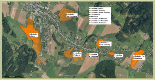
From 2013 to 2015 there were eighteen erosion events reported in the monitoring system with sediment run-off originating from 7 arable areas within the cadastre of Rtyně-Podkrkonoší (see ). Amongst the eighteen erosion events, there was a repeated exposure of certain localities. The localities with the highest frequency of monitoring reports filed were Žabárna, Horní zastávka, Trhovka („S‘ and „I‘ localities) and Bohdašín. The locality of Žabárna, with the most frequent monitoring reports as regards erosion exposure, and the most serious off-site effects, was chosen for the further study.
Figure 1. Reported erosion within the Rtyně-Podkrkonoší cadastre (orange colour highlights the localities reported within the monitoring). Source: adapted from Monitoring of Agricultural Soils Erosion, http://me.vumop.cz (accessed March 2016).
provides a recent overview of land parcels, their areas, and erosion risk categorisation within the Žabárna locality. The first erosion event reported by the monitoring system was peak precipitation with an intensity of 28 mm on 9/06/2013. Erosion was reported in relation to land parcels with areas of 4.06 and 15.94 ha and gradients of 3.6° and 4.8°, respectively. These land parcels with maize cropping recurred in the subsequent monitoring reports (calendar dates as per ), whereby the sediment overflow started from more of the land parcels. The adverse effect was noted on-site and off-site (local road, gardens, water reservoir).
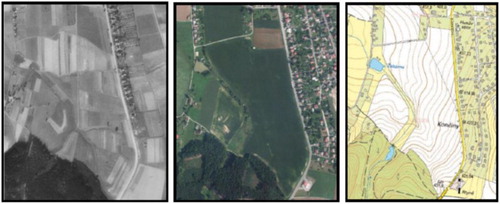
As a result of the repeated run-off events and the absence of crop rotation, the arable soils showed evidence of degradation processes, with topsoil sediment being transported into the Žabárna water reservoir. The practices required by GAEC, i.e. to apply barley buffers either in-field, or on headlands and margins, was followed, although effectiveness was mixed, with adverse effects on the most erosion-prone parcels. The practice of using organic fertiliser such as manure or slurry to supply biogas station rather than applying it to cropland had a further adverse effect on the soils in question. In the absence of crop rotation, continuous maize cropping does not build soil structure in the same way as clover or leguminous crops, which have deeper branched roots. An aggravating factor is, for two of the land blocks in question, the size of fields. is based on a regional archive research within the project. It provides a comparison of field size between the 1950s and the present.
Figure 2. Comparison of field size in relation to the Žabárna locality: the 1950s (left), the present view (middle), and the map (right). Source: Regional Library Trutnov 2016.
Efficiency of erosion measures
presents land parcel characteristics in relation to seven localities within the Rtyně-Podkrkonoší cadastre, including the Žabárna case. It compares the erosion risk methodology based on GAEC compliance to the Cp methodology based on the USLE equation.
The overall area that was monitored with respect to erosion events within the Rtyně-Podkrkonoší cadastre was 138.54 ha. Following GAEC 5, an area of 111.58 ha was classified as No Risk (i.e. 80.54% of arable soils within the cadastre), while the Cp method classified only 30.3 ha (i.e. 21.68%) as being without risk. GAEC 5 is thus less strict than the Cp method. Taking the above data as a starting point, we calculated yearly values of average soil loss G (t/ha/y) using the USLE model (see ), based on the individual factor values as recommended for the different specific conditions by Janeček et al. (Citation2007). Compared to a tolerable soil loss of 4 t/ha/y for the Rtyně-Podkrkonoší cadastre, we ascertained much higher soil loss values for the 2012–2015 time period.
Table 4. Calculations relating to yearly average soil losses on land parcels in seven localities of the Rtyně-Podkrkonoší cadastre.
also shows that the tolerable soil loss per hectare was exceeded for all land parcels addressed by the given monitoring reports, even though 80% of land parcels were classified as No Risk following GAEC 5. It is especially alarming that one locality exhibited a yearly soil loss per hectare nine times higher than the tolerable rate.
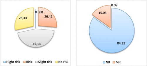
For the purposes of validation, similar analyses were carried out for the Dubenec and Kocbeře cadastres within the Trutnov region. With respect to the 2012–2015 period, 94% and 73% of the land blocks for which erosion reports were filed were classified as No Risk by GAEC 5. The results are only marginally different from the abovementioned outcomes for the Rtyně-Podkrkonoší cadastre, where 80% of land blocks for which erosion reports were filed were classified as No Risk by GAEC 5. provides comparative information regarding the three cadastres in the Trutnov region in relation to the proportion of soils prone to risk according to Cp (left) and according to GAEC 5 (right). Cp resulted in over 28% of soils (107.37 ha) in the Trutnov region being classified as No Risk, whilst GAEC 5 resulted in around 86% (321.33 ha) being classified as No Risk.
Figure 3. The proportion of erosion-prone soils in the Trutnov region in 2015 according to method of soil risk classification according to GAEC (right) and Cp method (left). Source: own presentation based on the results.
The erosion measures proposed for the Žabárna locality were mostly the reversion to grassland and crop rotations to be used on the surrounding land parcels. Whilst terraces tend to be recommended in similar situations in other biogeografical regions, it is not a characteristic feature of the Czech Republic farmland, therefore it was not comprised in the design of measures. Earthy banks (instead of terraces) were recommended by the earlier science of the region, however they are too costly to propose to farmers, in addition to the complications linked to the settling of property rights by tenant farmers. Incorporation of plant residues was not considered as an additional erosion measure, as it is already internalised in practice via the soil organic matter standard.
Discussion and Conclusions
In this study, monitoring reports of water erosion events occurring within the Trutnov region from 2012 to 2015 were evaluated, taking specific note of 14 cadasters. The evaluation of efficiency of erosion measures was carried out, whilst taking into account (i) implications of the different erosion risk classifications according to GAEC and Cp method, and (ii) qualitative reconstruction of the cause–effect links in terms of land management, bioclimatic and biophysical factors, as well as farmer's adaptive capacity. In addition to the USLE model, qualitative methods (interviews, field research, photo collection) were used. The majority of reports were from Rtyně-Podkrkonoší (18 reports), followed by Dubenec (10 reports) and Kocbeře (4 reports). The abovementioned case concerning the Žabárna locality demonstrates the highest risk to soil conservation due to the most frequent events within the Rtyně-Podkrkonoší cadastre. The erosion rates of the Žabárna locality are not superior to other localities of Rtyně (). The factors in the more serious erosion effects of the Žabárna locality are, based on the qualitative research methods, the topography of the fields and a history of farm system (absence of rotations). Following the Cp factor for the most risk-prone land block within the Žabárna locality, maize cropping should have been applied only on 0.11 ha, whilst the current land use applies maize cropping to an overall area of 15.94 ha. Average soil loss was calculated to be 20.09 t/ha/y. This was nine times higher than the tolerable level of soil erosion (4 t/ha/y) calculated for the region by Janeček et al. (Citation2007), and about fifteen times higher than 1.4 t/ha/y, the threshold for tolerable soil according to the EU (Verheijen et al. Citation2009). It also greatly surpasses the mean rate of soil erosion by water in the EU-27 (2.76 t/ha/y), as calculated by Jones et al. (Citation2012). It would be interesting to better understand the comparison of the soil loss of this locality to other soils with a similar topography (sloping soils) in the EU, however we are not aware that such selective data evaluation was made to date. The utility of the type of analysis herewith documented is above all for the Trutnov region whereby the responsibility lies in relation to remedy the adverse effects of erosion. The study may serve as the preliminary basis for the decisions of investments when conservation measures are introduced and a territorial land plan is prepared. The evaluation of the monitoring data within localities repeatedly exposed to erosion, as presented in this study, may be applicable in further regional areas related to less favoured farmland (especially LFA-M, in mountains) of the EU.
Consistency was found in relation to a number of authors who emphasise the importance of appropriate farming practices to reduce the adverse soil-related effects, for the Czech Republic discussed and designed by Hůla et al. (Citation2003), Cermakova et al. (Citation2014), Janeček et al. (Citation2007), Kadlec et al. (Citation2014), and for Europe at large by Boardman et al. (Citation2003), Boardman and Favis-Mortlock (Citation2014), Cerdan et al. (Citation2014) and Bakker et al. (Citation2008). However, the present study also highlighted how complex such decisions at farm level are in less favoured area when farmer knowledge of soil ecosystem issue is deficient. It is possible to confirm the finding by Cermakova et al. (Citation2014) that adjustments in a continuous slope length, conditioned by the size of land plots, played an important role in the amount of soil loss caused by water erosion. Above all, to protect soil from erosion and maintain soil quality, it is necessary to reduce the size of land blocks farmed by tenants and improve crop rotation systems.
At larger scales, impact of soil erosion issues on soil carbon levels, as marked by Jones et al. (Citation2012) is a problem that needs studying. No less important, the linkages of soil erosion of land tenure (Sklenicka et al. Citation2015; Ulrich-Schad et al. Citation2016) is a problem also awaiting an additional study.
Our findings are consistent with Kuhlman et al. (Citation2010), and Posthumus et al. (Citation2013), who emphasise the difficulty of verifying off-farm costs of erosion incidents. Our terrain observation provides evidence that the remediation of erosion damage to residential areas, the water reservoir, and the local road had to be covered repeatedly by the municipal budget. Private costs, alongside expenditure relating to the clean-up of the water reservoir, were not accounted for. Also unaccounted were costs of soil loss, including the soil ecosystem services such as water retention capacity.
Conversion to grassland is the measure recommended for the most-at-risk land parcels. We support the results by Cerdan et al. (Citation2014), although these do not discuss the technical details of a conversion-to-grassland measure. Still, there is a good deal of consensus on the utility, although farmers tend to be reluctant to bear such costs without compensation. An especially effective technical measure is to divide large sloping land parcels with an earthy depression; however, this measure runs into the problem of settling property rights with regard to land owners, and is also costly. To employ crop rotations appropriate to the cereal region is also recommended as a farm-system related measure.
Our investigation demonstrates that soil conservation may function well, if it is based on adequate legislative protection. The data collected show that legislation was respected with regard to all land parcels that were the subject of erosion monitoring reports in the 2012–2015 period. However, the evidence suggests that the GAEC 5 compliance methodology is more lenient than the Cp methodology in identifying risk-prone soils. With regard to monitoring reports for the Rtyně-Podkrkonoší cadastre from 2012 to 2015, 80% of land blocks for which erosion reports were filed, No Risk was classified by GAEC 5. The results are similar to the monitoring outcomes in relation to the Dubenec and Kocbeře vicinities, where 94% and 73% of the land blocks for which erosion reports were filed, No Risk was classified by GAEC 5. One of the findings relates to limited effectiveness of existing GAEC 5 compliance requirements. It enabled the farmer to opt for the practices with least costs in order to operate a local biogas station; however, such a choice was ineffective for maintaining the given soil conditions. Our findings concur with Fraser (Citation2004), and Cermakova et al. (Citation2014) to the effect that farmers who do not own their land and therefore, plant more crops with short-term returns. Thus, it appears that improvements are needed in research and policy to take into account the role of the tenant in farmland conservation. Of note is the recent evolution of the considerably stricter classification of soil risk according to GAEC, in place since 2017 and further changes to follow in 2018.
Based on qualitative questionnaires, in-person interviews and archive research, these results corroborate the findings of Louwagie et al. (Citation2009). Their research also showed that compliance with standards, where technically difficult or where costs are prohibitive, cannot be enforced through increased sanctions or greater regulation. In relation to such problems, it is increasingly important to put in place motivating measures to support farmers’ awareness through agricultural consultancy. In addition, further research must investigate beyond the biophysical and bioclimatic factors to overcome technical or economic obstacles in practice. Farm viability concerns in less favoured areas must be balanced with soil conservation. Computerised approaches to identify the fields most at risk should be mainstreamed to complement land-use maps available to farmers via LPIS, so that farm consultants have a strong basis to highlight the land management implications of such risks.
One of the most important findings from this study is that farms in hilly regions struggle most to balance commercial goals with the demands of soil conservation, as transpired from field research, in-person documentation and archive research. This finding supports the points emphasised by Godone et al. (Citation2013), De Baets et al. (Citation2013), and Navas et al. (Citation2012). Moreover, as land use changes are ongoing to convert agricultural land in the close surrounding of towns, agricultural production is shifted to hilly regions where erosion risks are more serious (Jones et al. Citation2012; Janků et al. Citation2016). The fact that farm system and farming practices via GAEC compliance do not suffice should be acknowledged through efforts to employ the best agroecology, sociology, agronomy and practical farm economics research in the redesign of educative measures to transfer the existing knowledge in practice so that farmer's adaptive capacity is strengthened in areas classified as erosion-prone areas. This might be topical when the new model of environmental measures is prepared at the level of individual region under the agricultural policy reform for the post 2020 period. In relation to rural development measures from 2014 to 2020, several opportunities exist to facilitate improved soil conservation at farm level.
The following conclusions can be drawn. First, in reference to the respondents in the region, it is important to strive to maintain or improve the legislative measures or policy recommendations as per soil conservation. However, all this cannot replace education or individual farmer responsibility when the design of soil conservation is made. As a practical solution, strengthen the regional knowledge transfer of farming practices with the best knowledge documented by international science. It was noted that farmland in the most risk-prone locality was managed by a tenant company focused on maize production for a local biogas station, thus farming practices were specifically focused on short-term return. Hence the practical solutions should pay utmost attention to the soil conservation and economy balance. Second, arguments should be voiced anew, in a transparent manner to overcome the conflict between long-term visions of landscape conservation and the desire for short-term economic returns. Arguments at centralised political level should not replace the acutely needed emphasis, to be discussed regionally wherever feasible, on the awareness of regulations and social obligations. Support to enhance the adaptive capacity of farmers (Dwyer et al. Citation2007) appears necessary so they can act on their own knowledge to implement appropriate land management measures for soil conservation. Third, for the optimal functioning of a well-adjusted system of agricultural payments, adequate legislative compliance measures such as GAECs are necessary. Given the Czech Republic's commitments to mainstream adaptation measures within rural development policy, preparing stricter erosion measures through GAEC appears advisable. The summary policy evaluation for 2018 is an opportunity that should not be missed.
Acknowledgment
This work was supported by the Ministry of Education, Youth and Sports of the Czech Republic under the Institutional Support Programme for the long-term conceptual development of research institutions. Thanks to anonymous reviewer for comments on the first draft of the paper.
Disclosure Statement
No potential conflict of interest was reported by the authors.
Notes on contributors
Jana Poláková is an Assistant Professor of rural policy at the Department of Agroecology and Biometeorology, Faculty of Agrobiology, Food and Natural Resources, Czech University of Life Sciences, Prague, the Czech Republic. Her research interests are soil protection standards, Common Agricultural Policy (CAP) and farm-level sustainability assessments.
Jaroslava Janků is an Associate Professor at the Department of Soil Science and Conservation, Faculty of Agrobiology, Food and Natural Resources, Czech University of Life Sciences, Prague, the Czech Republic. Her research interests are landscape ecology, soil conservation measures and cadastral data assessments.
Martina Nocarová completed her Master of Rural Policy and Agriculture at the Department of soil science and conservation of Czech University of Life Sciences, Prague, the Czech Republic.
ORCID
Jana Poláková http://orcid.org/0000-0001-6166-1943
Additional information
Funding
References
- Armas-Herrera C, Mora J, Guerra J, Arbelo C, Rodríguez-Rodríguez A. 2013. Depth distribution of humic substances in Andosols in relation to land management and soil erosion. Soil Use Manage. 29:77–86. doi:10.1111/sum.12013.
- Bakker M, Govers G, Doorn A, Quetier F, Chouvardas D, Rounsevell M. 2008. The response of soil erosion and sediment export to land-use change in four areas of Europe: the importance of landscape pattern. Geomorphology. 98:213–226. doi:10.1016/j.geomorph.2006.12.027.
- Boardman J, Favis-Mortlock D. 2014. The significance of drilling date and crop cover with reference to soil erosion by water, with implications for mitigating erosion on agricultural land in South East England. Soil Use Manage. 30:40–47. doi:10.1111/sum.12095.
- Boardman J, Poesen J, Evans R. 2003. Socio-economic factors in soil erosion and conservation. Environ Sci Policy. 6:1–6. doi:10.1016/S1462-9011(02)00120-X.
- Cerdan O, Morvan X, Issa O, Naisse C, Desprats J, Combaud A. 2014. Effect of ground-cover type on surface runoff and subsequent soil erosion in Champagne vineyards in France. Soil Use Manage. 30:372–381. doi:10.1111/sum.12129.
- Cermakova O, Janecek M, Jindrova A, Korinek J. 2014. The impact of farming and land ownership on soil erosion. AM J AGR ECON. 62:883–890. doi:10.11118/actaun20146205088. 3.
- De Baets S, Vanacker V, Van Oost K, Meersmans J, Quine T. 2013. Spatial variability and change in soil organic carbon stocks in response to recovery following land abandonment and erosion in mountainous Drylands. Soil Use Manage. 29:65–76. doi:10.1111/sum.12017.
- Dumbrovský M, Korsuň S. 2009. Optimisation of soil conservation systems within integrated territorial protection. Soil Water Res. 4:57–65. doi: 10.17221/27/2008-SWR
- Dwyer J, Ingram J, Mills J, Taylor J, Burton R, Matthews K, Schwarz G, Slee R. 2007. Understanding and influencing positive environmental behaviour among farmers and land managers – a project for Defra. Gloucester: CCRU. London: Department for Environment, Food and Rural Affairs; p. 1-49.
- European Commission. 2009. Staff working document accompanying the white paper – adapting to climate change: the challenge for European agriculture and rural areas. COM (2009)147. Brussels; p. 1–12.
- [FAO] Food and Agriculture Organisation. 2012. World agriculture towards 2030/2050: the 2012 revision. Alexandratos N, Bruinsma J, editors. Rome: Agricultural Development Economics Division, Food and Agriculture Organization. p. 59–92.
- Fraser E. 2004. Land tenure and agricultural management: soil conservation on rented and owned fields in southwest British Columbia. Agric Hum Values. 21:73–79. doi:10.1023/B:AHUM.0000014020.96820.a1.
- Fukunaga K, Huffman W. 2009. Role of risk and transaction costs in contract design: evidence from farmland lease contracts in U.S. Agriculture. A J Agric Econ. 91:237–249. doi:10.1111/j.1467-8276.2008.01164.x.
- Godone D, Stanchi S, Freppaz M, Zanini E. 2013. Assessing the susceptibility of alpine soils to erosion using soil physical and site indicators. Soil Use Manage. 29:586–596. doi:10.1111/sum.12063.
- Hendl. 1999. Qualitative assessment – methods. Prague: Karolinum Press. p. 278. ISBN 8024600307.
- Hůla J, Janeček M, Kovaříček P, Bohuslávek J. 2003. Conservation practice in relation to erosion. Prague: Research Institute for Melioration and Soil Conservation. p. 1–47. ISSN 1211-3972.
- Iglesias A, Avis K, Benzie M, Fisher P, Harley M, Hodgson N, Horrocks L, Moneo M, Webb J. 2007. Adaptation to climate change in the agricultural sector. Report to Directorate-General Agriculture. London, Madrid: AEA Energy & Environment. p. 23–98.
- Janeček M, Dostál T, Dufková J, Dumbrovský M, Hůla J, Kadlec V, Konečná J, Novotný I, Podhrázská J, Procházková E, et al. 2007. Conservation of agricultural soils in relation to erosion. Prague: Research Institute for Melioration and Soil Conservation. p. 1–76. ISBN 978-80-254-0973-2.
- Janků J, Sekáč P, Baráková J, Kozák J. 2016. An analysis of land in terms of protection of farmland. Soil Water Res. 11:20–28. doi: 10.17221/163/2015-SWR
- Jones RA, Panagos P, Barcelo S, Bouraoui F, Bosco C, Dewitte O, Gardi C. 2012. The state of soil in Europe. A contribution to the European environment agency’s environment state and outlook report. Brussels: European Commission Joint Research Centre. p. 1–79.
- Kadlec V, Dostál T, Vrána K, Devátý J, Podhrázská J, Heřmanovská D, Novotný I, Papaj V. 2014. Designing technical erosion measures. Prague: Research Institute for Melioration and Soil Conservation. p. 1–98. ISBN: 978-80-87361-29-0.
- Kapler P, Picková A. 2007. Analysis of agricultural measures to adapt to climate change in the Czech Republic. Brno: Research Institute of Agricultural Economics. p. 13-40.
- Kessler A, De Graaff J, Olsen P. 2010. Farm-level adoption of soil and water conservation measures and policy implications in Europe. Land Use Policy. 27:1–3. doi:10.1016/j.landusepol.2008.08.008.
- Kuhlman T, Reinhard S, Gaaff A. 2010. Estimating the costs and benefits of soil conservation in Europe. Land Use Policy. 27:22–32. doi:10.1016/j.landusepol.2008.08.002.
- Louwagie G, Gay S, Burrell A. 2009. Addressing soil degradation in EU agriculture: relevant processes, practices and policies. Report on the project sustainable agriculture and soil conservation (SoCo). Brussels: European Commission Joint Research Centre. p. 79-83.
- [LPIS]. Land Parcel Information System. 2016. [accessed March 2016]. http://eagri.cz/public/web/mze/farmar/LPIS/.
- Monitoring of Agricultural Soils Erosion. 2016. [accessed March 2016]. http://me.vumop.cz/mapserv/monitor/.
- Ministry of Environment. 2017. Strategy for adaptation to climate change in the Czech Republic. Prague: Ministry of Environment of the Czech Republic. p. 30-36.
- Navas A, Gaspar L, Quijano L, López-Vicente M, Machín J. 2012. Patterns of soil organic carbon and nitrogen in relation to soil movement under different land uses in mountain fields (South Central Pyrenees). Catena. 94:43–52. doi:10.1016/j.catena.2011.05.012.
- Nunes A, de Almeida A, Coelho C. 2011. Impacts of land use and cover type on runoff and soil erosion in a marginal area of Portugal. Appl Geogr. 31:687–699. doi:10.1016/j.apgeog.2010.12.006.
- Petersen JE, Hoogeveen Y. 2004. Agriculture and the environment in the EU accession countries. Implications of applying the EU common agricultural policy. Copenhagen: European Environment Agency. p. 20-21. ISBN: 92-9167-637-3.
- Posthumus H, Deeks L, Rickson R, Quinton J. 2013. Costs and benefits of erosion control measures in the UK. British society of soil science. Soil Use Manage. 31(S1):16–33. doi:10.1111/sum.12057.
- Sklenicka P, Janeckova K, Salek M, Simova P, Vlasak J, Sekac P, Janovska V. 2015. Owner or tenant – who adopts better soil conservation practices? Land Use Policy. 47:253–261. doi:10.1016/j.landusepol.2015.04.017.
- Trnka M, Kyselý J, Možný M, Dubrovský M. 2009. Changes in central-European soil-moisture availability and circulation patterns in 1881–2005. Int J Climatol. 29:655–672. doi:10.1002/joc.1703.
- Ulrich-Schad J, Babin N, Ma Z, Prokopy L. 2016. Out-of-state, out of mind? Non-operating farmland owners and conservation decision making. Land Use Policy. 54:602–613. doi:10.1016/j.landusepol.2016.02.031.
- Verheijen F, Jones R, Rickson R, Smith C. 2009. Tolerable versus actual soil erosion rates in Europe. Earth-Sci Revi. 94:23–38. doi:10.1016/j.earscirev.2009.02.003.
- Wischmeier W, Smith D. 1978. Predicting rainfall erosion losses: a guide to conservation planning. Agricultural handbook No. 537. Washington, DC: U.S. Department of Agriculture. p. 1–51.