Abstract
The issue of soil organic carbon (SOC) is of increasing concern. Because SOC, as an important soil component in farming systems, is essential for improving soil quality, sustaining food production and quality, and maintaining water quality and as a major part of the terrestrial carbon reservoir, it plays an important role in the global carbon cycle. In this paper, a total of 665 soil samples from different depths were collected randomly in the autumn of 2007, and the spatial variability of SOC content at a small catchment of the Loess Plateau was analysed using classical statistics and geo-statistical analysis. In nonsampled areas classical kriging was utilized for interpolation of SOC estimation. The classic statistical analysis revealed moderate spatial variability with all five layers of SOC-content. In addition, the average SOC content decreased with soil depth and the relationship can be modelled by an exponential equation (y=3.1795x −1.2015, R 2=0.9866) and all of the SOC-content data in the different depth were normally distributed. The geo-statistical analysis indicated a moderate spatial dependence in 0–60 cm, while in the 60–80 cm depth spatial dependence was strong. The semi-variogram could be fitted by an exponential model for 0–10 cm depth; by a spherical model for 10–20 cm depth and 60–80 cm depth; and by a Gaussian model for 20–60 cm depth. The range increases with increasing depth. In addition, classical kriging could successfully interpolate SOC content in the catchment. In general, the geo-statistics method on a watershed scale could be accurately used to evaluate spatial variability of the SOC content in the Loess Plateau, China.
Keywords:
Introduction
As an important soil component in farming systems, soil organic carbon (SOC) is essential for improving soil quality, sustaining food production and quality, and maintaining water quality (Singh et al., Citation2007). The SOC, therefore, has been proposed as an indicator of soil quality (DEFRA, Citation2004). The SOC stock, as a major part of the terrestrial carbon reservoir, plays an important role in the global carbon cycle. In terrestrial ecosystems, the SOC stock is nearly three times as large as carbon storage in vegetation (Schlesinger, Citation1990), and twice as large as global atmospheric carbon storage (Lal, Citation2004). Owing to the large quantity stored in terrestrial ecosystems, a slight change in SOC will affect the density of greenhouse gases in the atmosphere. With increasing awareness of the threat posed by global warming that exacerbates environmental problems and endangers human sustainability, the global communities, both international and national, have focused their attention on alleviating global warming through reducing carbon emissions or increasing carbon sequestration (Marland & Schlamadinger, Citation1999; Wang & Zhou, Citation1999; Fang & Chen, Citation2001; Pan et al., Citation2002; Li et al., Citation2003; Han et al., Citation2004; Morisada et al., Citation2004). As the upper layer of the lithosphere, the pedosphere not only provides the substrate for plants to grow, but also is the interface of the atmosphere, lithosphere, hydrosphere and biosphere (Schindler, Citation1999). Thus, the soil carbon pool could actively exchange carbon with the atmospheric carbon pool (Wang & Hsieh, Citation2002). A series of studies on estimating the SOC stock and distribution patterns in the soil on global, continental, country, and regional scales have been reported, such as the work done by Sundquist (Citation1993) on the global carbon dioxide budget, the work by Morisada et al. (Citation2004) on the organic carbon stock in forest soils in Japan, and some of the studies done by Chinese scientists (Li & Wang, Citation2000; Wang et al., Citation2000; Li et al., Citation2001; Sun et al., Citation2004; Xie et al., Citation2004) to estimate the soil carbon pool of China and to reveal its distribution patterns.
However, owing to varied data sources, a lack of complete inventory data, and the inherent spatial variability of SOC, estimation of SOC distribution has varied from one study to another (Xie et al., Citation2004), Especially for the region of the Loess Plateau, where is characterized by extremely complex topography, and significant topographic variability with typical Loess hills and gully slope shapes (Li et al., Citation2008), which theoretically should result in a large variability in the spatial distribution of SOC. Although some studies have been conducted on spatial variability of SOC (Conant & Paustain, Citation2002; Schoning et al., Citation2006; Stavi et al., Citation2008), Because of the extremely complex topography there is little study about SOC in the Loess Plateau. Only a few experiments have been done on the slope scale (Wang et al., Citation2001; Fu et al., Citation2003).
The objectives of this work were: 1) to estimate the vertical variability of SOC in a small catchment of the Loess Plateau in northern Shaanxi, China; 2) to reveal the spatial variability of SOC in the catchment, and 3) to assess SOC distribution in the catchment.
Materials and methods
The study area
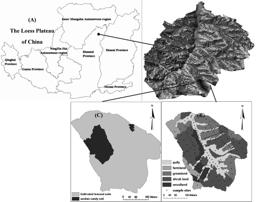
The study catchment, located in Shenmu County, Shaanxi Province, China (38° 46′ to 38° 51′ N, 110° 21′ to110° 23′ E) (), is typical of the gullied-hilly area of the Loess Plateau. The watershed has a temperate semiarid climate with a mean annual temperature of 8.4 °C. The mean annual precipitation is 549 mm. Most precipitation occurs in a few large storms, with 77.4% of the annual precipitation falling during the flood season from June to September. The main soil (cultivate loessial soil) is an Ust-Sandiic Entisol which is loess-derived and easily erodible, apart from two small areas of Aeolian sandy soil (). As a result, the region is characterized by steep gullies and hills (Tang et al., Citation1993). The main vegetation is purple medick (Medicago sativa), scattered shrub (Caragana korshinskii), spare poplar (Populus simonii), and little farmland ().
Figure 1. Location of the study area in Shenmu, Shaanxi Province, China (A), the land use (B), and soil types (c) of the catchment.
Soil sampling and chemical analysis
A portable Garmin Summit GPS receiver was used to locate the sampling sites. The sampling sites () were chosen to represent all landform types in the catchment. A depth of 0–80 cm was divided into five layers, 0–10 cm, 10–20 cm, 20–40 cm, 40–60 cm, and 60–80 cm. All of the samples were collected with a 5-cm-diameter hand auger. After being air-dried, samples were passed through a 1-mm sieve for laboratory analysis. In this study soil samples were collected on 169 locations randomly in the watershed and the total number of samples was 665.
SOC content was determined using the dichromate oxidation (external heat applied) method (Nelson & Sommers, Citation1975)
Statistical analysis
In this study classical and geo-statistical analyses were combined to characterize spatial variability of the soil nutrients. Mean and standard deviation (SD) were computed for each soil depth with the software package SPSS13.0. GS+7.0 software was used to perform all geostatistical computations. Software package ArcGIS 9.0 was used to estimate the unsampled locations.
The basic theory of geostatistics has been well established (Journel & Huijbregts, Citation1978) and reviewed (Trangmar et al., Citation1985). The experimental variogram estimator is asymptotically unbiased for any intrinsic random function; however, it is very sensitive to outlying values because it is based on squared differences among data. Apart from identifying outliners by exploratory data analysis, a robust variogram [Equation (Equation1)] is a good estimator to reduce the sensitiveness to outliers (Liu et al., Citation1996):
The degree of spatial dependence(GD) was calculated as in Equation (Equation5):
The simulate precision can be reflected by coefficient R 2, calculated as shown in Equation (Equation6):
Result and discussion
The classical analyses of SOC content
The classical analyses of SOC contents for the five depths are shown in . The mean contents of SOC in the five depths of the catchment are different. SOC decreases with increasing depth and the trend could be modelled by the exponential Equation (Equation8) ().
Figure 2. Mean SOC content at different depths.
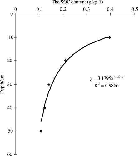
Table I. Classical analyses of the SOC parameters.
A previous study of the spatial variability of soil properties has shown that the soil properties are not independent but instead are stochastic variables (Nielsen et al., Citation1983). This is caused by the continuity of the soil-forming processes and the gradual change of the climate. So it is necessary to traverse the spatial variability of the SOC using the geo-statistical analyses method. However, if the data are not normally distributed, the scale effect will affect the variance function. Before geo-statistical analyses, we tested the data with a one-sample Kolmogorov–Smirnov test (Meulman & Heiser, Citation2001). In this study the data of SOC content at different depths were normally distributed ().
Table II. The variance function model and parameters for SOC.
The geo-statistical analyses of SOC distribution
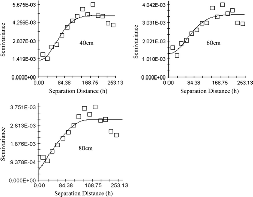
Semi-variances were computed at different lags (multiples of the sampling interval of 12.5 m) using Equation (Equation1). The semi-variance charts of SOC distribution are shown in and the variance function model and parameters for SOC are shown in . The semi-variogram was fitted by exponential model in the 0–10 cm depth; by spherical model in the 10–20 cm and 60–80 cm depths; and by Gaussian model in 20–60 cm depth. All of the regression coefficients’R 2-values were higher than 0.755. From this we know that the semi-variogram can be effectively modelled. Through the F-test the R 2-values of all nutrients in the catchment were prominent. C 0 is the nugget that is caused by random factors like fertilizer application, crop planting, and soil management. C 0+C is the sill that is the value when the semi-variogram doesn't increase with increasing distance. The sill indicates the total variance. So C is the variance that is caused by the property of soil parent materials, climate, and terrain (Chien et al., Citation1997). The nugget effect (GD) is the ratio of C 0 to C 0+C. The GD relative degrees of <25%, 25–75%, and >75% could be used to describe the proportion of the spatial structure that showed strong, moderate, and weak spatial autocorrelation, respectively (Cambardella et al., Citation1994). In this catchment C 0 decreased with increasing depth. A possible reason is that the SOC for the deeper layer is less affected by stochastic factors. As for the values for GD, they were lower in the 0–60 cm depth, showing a moderate spatial dependence, while in the 60–80 cm depth they showed a high magnitude of spatial dependence. The range (h) of the semi-variograms was the distance at which semi-variance attained the maximum value (sill), and the sill approximately equalled the sample variance (Journel & Huijbregts, Citation1978). The range expressed as a distance could be interpreted as the diameter of the zone of influence that represents the average maximum distance over which a soil property of two samples was related. At distances less than the range, measured properties of two samples became similar with decreasing distance between the two points. Thus, the range provides an estimate of areas of similarity. In the catchment, the range increased with increasing depth. The lowest value (only 79.8 m) was in surface soil but this value was still larger than the distance of sampling locations (15 m).
Figure 3. Semi-variance charts of SOC distribution.
The SOC spatial distribution
The maps of the SOC content distribution can clearly characterize the concrete distribution in the catchment. In order to obtain good spatial patterns, the spatial changes of SOC content for unsampled locations can be directly interpolated with classical kriging in the ArcGIS software based on the observed semi-variogram values (Smith et al., Citation1993; Goovaerts & Journel, Citation1995). According to the correlation length, 12 neighboring samples were in the correlation length. To obtain the overall patterns of the SOC distribution, the spatial interpolation method of kriging was applied with 12 neighboring samples used for estimation of each grid point. The distribution of SOC content for five depths in the study area is shown in .
Figure 4. Spatial distribution of SOC content in the catchment.
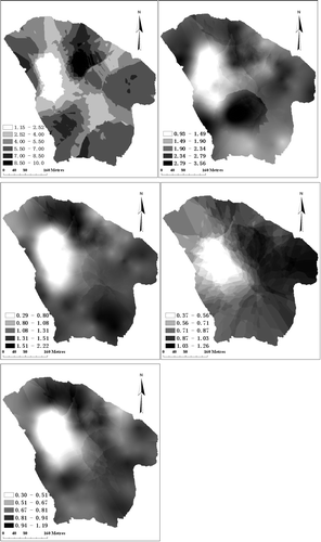
The topsoil layer (0–10 cm) contained more SOC than did the other layers, and the horizontal variability of the topsoil layer was strong. The SOC content in the middle of the catchment, where the gully terrain was, was lower than in other places. The lowest SOC content was in the northwest part of the catchment, with the sandy soil. In the layer at 10–20 cm depth there were two obvious spots. One was the highest-content spot in the southwest and the other was the lowest-content spot in the northwest of the catchment and the range is 2.63 g kg−1. The horizontal variability of the other three layers from 20–80 cm was similar and the SOC content was lower. A previous study had shown that structural factors, such as parent material, climate, terrain, and water table, as well as random factors, such as fertilizer application, crop planting, soil management, and co-determined soil properties, can effect the SOC distribution (Goovaerts, Citation1999). In this catchment, the area is small, only 0.3 km2. So the climate and parent materials are similar. The SOC variable is caused mainly by soil type, landscape, and other human activity, especially the soil type. The lower SOC content spots (white spots) of the SOC distribution maps at different depth were covered by Aeolian sandy soil, and most of the higher SOC content spots (black spots) were covered by wood or shrub (). The human activity affected mainly the topsoil. The classical analyses of SOC content for five depths in the study area show moderate spatial dependence, because the CV of the different layers is from 32.91 to 50.84%, between 10 and 100%. But through the geo-statistical analyses the values of GD at 0–60 cm depth were lower, showing a moderate spatial dependence, while at the 60–80 cm depth the value was different from that from the classical analyses, showing a high magnitude of spatial dependence. So if we want to know the true variability of the soil properties, the geo-statistical analyses is a useful method.
The classic statistical analysis showed that the mean SOC content at different depths of the catchment decreased with increasing depth, and the trend could be modelled by exponential Equation (Equation9).
The SOC content at different depths showed moderate spatial variability, and all of the SOC content data at different depths were normally distributed. However, the geo-statistical analysis indicated that the values of GD in the 0–60 cm range were lower, showing a moderate spatial dependence, while at 60–80 cm depth GD showed a high magnitude of spatial dependence. The semi-variogram could be fitted by an exponential model for 0–10 cm depth; by a spherical model for 10–20 cm depth and 60–80 cm depth; and by a Gaussian model for 20–60 cm depth. The range increased with increasing depth. In addition, kriging could successfully interpolate SOC content in the catchment. In general, the geo-statistics method could be well used to evaluate spatial variability of the SOC content at the watershed scale in the Loess Plateau, China.
Acknowledgements
Financial support of this research was jointly provided by National Key Basic Research Support Foundation of China (No.2007CB106803), “Innovation Team” Grant of Northwest Sci-Tech University of Agriculture and Forestry, National Research Support Foundation of China (No.2006BAD09B06), West Light Foundation of The Chinese Academy of Sciences. (2006YB04), IRP0749.
References
- Cambardella , C. , Moonan , T.B. , Nocak , J.M. , Patkin , T.B. , Katlem , D.L. , Turvo , R.F. and Konopa , A.T. 1994 . Field scale variability of soil properties in central Iowa soil . Soil Science Society of America Journal , 47 : 1501 – 1511 .
- Chien , Y.J. , Lee , D.Y. , Guo , H.Y. and Houng , K.H. 1997 . Geostatistical analysis of soil properties of mid-west Taiwan soil . Soil Science , 162 : 151 – 162 .
- Conant , R.T. and Paustian , K. 2002 . Spatial variability of soil organic carbon in grasslands: implications for detecting change at different scales . Environmental Pollution , 116 : S127 – S135 .
- DEFRA 2004 . The first soil action plan for England (2004–2006) 36 37 . London, , UK : Department of the Environment, Food and Rural Affairs .
- Fang , J.Y. Chen , A.P. 2001 . Dynamic forest biomass carbon pools in China and their significance . Acta Botanica Sinica , 43 , 967 973 (in Chinese) .
- Fu , B.J. , Chen , L.D. , Ma , K.M. , Zhou , H.F. and Wang , J. 2003 . The relationships between land use and soil conditions in the hilly area of the Loess Plateau in northern Shaanxi, China . Catena , 39 : 69 – 78 .
- Goovaerts , P. 1999 . Geostatistics in soil science: State-of-the-art and perspectives . Geoderma , 89 : 1 – 45 .
- Goovaerts , P. and Journel , A.G. 1995 . Integrating soil map information in modeling the spatial variation of continuous soil properties . European Journal of Soil Science , 46 : 397 – 414 .
- Han , B. , Wang , X.K. , Ouyang , Z.Y. , Cao , Z.Q. , Zou , D.Y. , Sun , H.D. , Zhu , P. Zhou , B.K. 2004 . Distribution and change of agro-ecosystem carbon pool in the northeast of China . Chinese Journal of Soil Science , 35 , 401 407 (in Chinese) .
- Journel , A.G. and Huijbregts , C.J. 1978 . Mining Geostatistics , 599 – 600 . New York : Academic Press .
- Lal , R. 2004 . Soil carbon sequestration to mitigate climate change . Geoderma , 123 ( 2 ) : 1 – 22 .
- Li , Z. , Sun , B. Lin , X.X. 2001 . Density of soil organic carbon and the factors controlling its turnover in East China . Scientia Geographica Sinica , 21 , 301 307 (in Chinese) .
- Li , Z.G. , Wang , Y.L. , Zhou , Q.B. , Wu , J.S. , Peng , J. and Chang , H.F. 2008 . Spatiotemporal variability of land surface moisture based on vegetation and temperature characteristics in Northern Shaanxi Loess Plateau, China . Journal of Arid Environments , 72 : 974 – 985 .
- Li , Z.P. Wang , X.J. 2000 . Analysis and evaluation of organic matter dynamics at a little regional scale . Scientia Geographica Sinica , 20 , 182 188 (in Chinese) .
- Li , Z.P. , Zhang , T.L. , Chen , B.Y. , Yin , R.L. Shi , Y.Q. 2003 . Soil organic matter dynamics in a cultivation chronosequence of paddy fields in subtropical China . Acta Pedologica Sinica , 40 , 344 352 (in Chinese) .
- Liu , G.S. , Jiang , N.H. , Zhang , L.D. Liu , Z.L. 1996 . Soil Physical and Chemical Analysis and Description of Soil Profiles 34 36 . Beijing : China Standardization Publishing House (in Chinese) .
- Marland , G. and Schlamadinger , B. 1999 . The Kyoto Protocol could make a difference for the optimal forest-based CO2 mitigation strategy: Some results from GORCAM . Environmental Science and Policy , 2 : 111 – 124 .
- Meulman , J.J. Heiser , W.J. 2001 . SPSS Categories 11.0 SPSS incorporated , Chicago 341 342 .
- Morisada , K. , Ono , K. and Kanomata , H. 2004 . Organic carbon stock in forest soils in Japan . Geoderma , 119 : 21 – 32 .
- Nelson , D.M. and Sommers , L.E. 1975 . A rapid and accurate method for estimating organic carbon in soil . Proceedings of the Indiana Academy of Science , 84 : 456 – 462 .
- Nielsen , D.R. , Patricia , M. and Tillotson , S.R. 1983 . Analyzing field measured soil water properties. Agriculture water management , 319 – 344 . New York : Academic Press .
- Pan , G.X. , Li , L.Q. Zhang , X.H. 2002 . Perspectives on issues of soil carbon pools and global change: With suggestions for studying organic carbon sequestration in paddy soils of China . Journal of Nanjing Agricultural University , 25 , 100 109 (in Chinese) .
- Schindler , D.W. 1999 . The mysterious missing sink . Nature , 398 : 105 – 106 .
- Schlesinger , W.H. 1990 . Evidence from chronosequence studies for a low carbon storage potential of soils . Nature , 348 : 232 – 234 .
- Schoning , I. , Totsche , K.U. and Ingrid , K.K. 2006 . Small scale spatial variability of organic carbon stocks in litter and solum of a forested Luvisol . Geoderma , 136 : 631 – 642 .
- Singh , S.K. , Singh , A.K. , Sharma , B.K. and Tarafdar , J.C. 2007 . Carbon stock and organic carbon dynamics in soils of Rajasthan, India . Journal of Arid Environments , 68 : 408 – 421 .
- Smith , J.L. , Halvorson , J.J. and Papendick , R.I. 1993 . Using multiple-variable indicator kriging for evaluating soil quality . Soil Science Society of America Journal , 57 : 743 – 749 .
- Stavi , I. , Ungar , E.D. , Lavee , H. and Sarah , P. 2008 . Grazing-induced spatial variability of soil bulk density and content of moisture, organic carbon and calcium carbonate in a semi-arid rangeland . Catena , 75 : 288 – 296 .
- Sun , W.X. , Shi , X.Z. , Yu , D.S. , Wang , K. Wang , H.J. 2004 . Estimation of soil organic carbon density and storage of Northeast China . Acta Pedologica Sinica , 41 , 298 301 (in Chinese) .
- Sundquist , E.T. 1993 . The global carbon dioxide budget . Science , 259 : 934 – 941 .
- Tang , K.L. , Hou , Q.C. , Wang , B.K. and Zhang , P.C. 1993 . The environment background and administration way of wind-water erosion crisscross region and Shenmu eoperimental area on the Loess Plateau. Memoir of NISWC . Academia Sinica and Ministry of Water Conservation , 18 : 2 – 15 .
- Trangmar , B.B. , Yost , R.S. and Uehara , G. 1985 . Application of geostatistics to spatial studies of soil properties . Advances in Agronomy , 38 : 45 – 94 .
- Wang , J. , Fu , B.J. and Qiu , Y. 2001 . Soil nutrients in relation to land use and landscape position in the semi-arid small catchment on the loess plateau in China . Journal of Arid Environments , 48 : 537 – 550 .
- Wang , S.Q. Zhou , C.H. 1999 . Estimating soil carbon reservoir of terrestrial ecosystem in China . Geographical Research , 18 , 349 356 (in Chinese) .
- Wang , S.Q. , Zhou , C.H. , Li , K.R. , Zhu , S.L. Huang , F.H. 2000 . Analysis on spatial distribution characteristics of soil organic carbon reservoir in China . Acta Geographica Sinica , 55 , 533 544 (in Chinese) .
- Wang , Y. and Hsieh , Y.P. 2002 . Uncertainties and novel prospects in the study of the soil carbon dynamics . Chemosphere , 49 : 791 – 804 .
- Warrick , A.W. and Nielsen , D.R. 1980 . “ Spatial variability of soil physical properties in the field ” . In Applications of Soil Physics , Edited by: Hillel , D. 319 – 344 . New York : Academic Press .
- Xie , X.L. , Sun , B. , Zhou , H.Z. and Li , A.B. 2004 . Soil organic carbon storage in China . Pedosphere , 14 : 491 – 500 .