
Abstract
Smart city is the development of digital city; as its main supporting technology, the digital city geo-spatial framework has to be upgraded to the temporal-spatial information infrastructure (TSII). First, this paper proposes the concept and basic framework of smart city and defines the concept of TSII – processes, integration, mining analysis, and share time-stamps geographic data – and the related policy, regulations and standards, technology, facilities, mechanism, and human resources. The framework has four components: the benchmark of time and space, temporal-spatial big data, the cloud service platform and the related supporting environment. Second, the temporal-spatial big data and cloud service platform are elaborated. Finally, an application of TSII constructed by the Xicheng District Planning Bureau in Beijing is introduced, which provides a useful reference for the construction of smart city.
1. Introduction
A city is not only an area in which the majority of active economic development occurs with the highest concentration of information, but also an area with the largest population and number of social management challenges (Liu, Gong, and Yu Citation2014). Urban modernization is the dominant driving force of social and economic development. To solve a series of problems in the development of urban modernization, scholars have proposed the concept of “digital city,” which originated from the “digital Earth.” In recent years, some scholars have also proposed the concept of the “smart city.” The Chinese Government pays significant attention to the construction of smart city, and the National New Urbanization Planning (2014–2020) has proposed an information network broadband, informative planning and management, intelligent infrastructure, convenient public services, modern industry, and fine social management. In 2014, the National Development and Reform Commission and other eight departments jointly issued “about promoting the guidance to the healthy construction of smart city” (referred to as Guidances in this paper) to strengthen coordination and promote healthy development. The National Development and Reform Commission, the Ministry of Science and Technology, Housing and Urban-Rural Development, Industry and Information Technology, and the National Geographic Information Bureau of Surveying and Mapping conducted exploratory trial work in their fields.
Smart city is the continuation of digital city, which is under the impetus of the National Geographic Information Bureau of Surveying and Mapping in China. Beginning in 2006, more than 300 cities in China performed construction on the Digital City Geographic Framework. By the integration of the urban population and legal, economic, social, and cultural information in an information platform, this framework becomes an indispensable information resource and supports information sharing and exchange among all departments and industries in the city (Li et al. Citation2013). Compared with digital city, smart city is supported by the Internet of Things, big data, cloud computing, mobile Internet, and other new technologies. At the stage of the smart city construction, new requirements for the existing geo-spatial framework are proposed regarding interaction experience, real-time response, mobility, control, and autonomy. The geo-spatial framework needs to be updated to a temporal-spatial information infrastructure (TSII) (Gong and Wang Citation2013; Wang et al. Citation2014).
To promote the construction of smart city in China, this paper introduces the concepts, framework, main technologies, and application of TSII. The paper is organized as follows: Section 2 introduces the related basic concepts, including the smart city and the TSII, and its historical evolution. Section 3 describes the temporal-spatial big data of the TSII. The main technology of a spatial–temporal information cloud platform is elaborated in Section 4. An application is presented in Section 5, and the paper is summarized in the last section.
2. Basic concepts
2.1. Smart city
Smart city is termed via the use of new generation information technologies (such as the Internet of Things, cloud computing, big data, and geographic information integration) to promote city planning, construction, management, and service (Guidances). From a developing point of view, digital city is in the preliminary phase of urban information. And smart city is an intelligent digital city and the extension of a digital city (Li, Shao, and Yang Citation2011). From a technical point of view, digital city can be seamlessly connected to physical city via the Internet of Things. Sensory data are processed in real-time using big data, cloud computing, and mobile Internet technologies and subsequently provide intelligent services. From a composition point of view, smart city should include real-time information intelligence equipment, such as human senses, or a human behavior organ system and a response and disposal thematic system.
Although these definitions substantially differ, the main purpose of smart city construction is to support intensive, intelligent, green, and low-carbon new urbanization development, and enable the market to have a decisive role in the allocation of resources. Smart city will motivate the government to collect material, information, and intelligence resources; promote the innovative application of a new generation of information technology; strengthen intelligent urban management and services; actively develop people’s livelihoods; effectively improve the comprehensive carrying capacity and well-being of urban residents; and promote the quality and level of urbanization development.
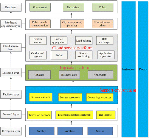
Based on the existing experiences of smart city construction both at home and abroad, each city has unique characteristics that are incorporated into a common total framework, and the construction stages and identified problems differ from one another (Li, Shao, and Yang Citation2012). As shown in Figure , the framework includes the perception layer, the network layer, the public facilities layer, the database layer, the cloud information platform layer, the wisdom application and user layer, and related system of Institution and Policy standards (Wang et al. Citation2014).
Figure 1. Framework of smart city construction.
2.2. Temporal-spatial information infrastructure
We introduce infrastructure and spatial information infrastructure. Infrastructure usually refers to the following: social production, people who provide public services, material engineering facilities which are employed to ensure the normal order of a country or region, and social economic activities of a public service system. Spatial information infrastructure primarily refers to the spatial data framework, spatial data coordination, the management and distribution system, the spatial data exchange website, and the spatial data transfer standards. Based on the spatial data infrastructure and information highway, the digital Earth technology is extensively applied to the Earth’s surface spatial data query, visualization, analysis, and knowledge mining (Liu, Gong, and Yu Citation2015; Liu, Zhang, and Gong Citation2014; Sui Citation2011).
The concept of TSII denotes the processes, integration, mining analysis, and sharing of time-stamps geographic data. It also includes related policy, regulations and standards, technology, facilities, mechanism, and human resources. TSII is the foundation of smart city construction; its construction is one of the important responsibilities of the Surveying and Mapping Geographic Information Department. The Guidances defines the TSII as the “basis of unified geo-spatial framework, TSII collects geo-spatial data and related database, and all related departments and industries business information can overlap on it.” As shown in Figure , the TSII primarily includes three main components: (1) Big data platform: gathering space-time information resources, integrate static real-time geographic information, and construct a temporal-spatial big data center. (2) Cloud service platform: using a service bus to construct a cloud service platform to support on-demand applications. (3) Supporting environment: the related policy, regulations, and standards.
2.3. From geographic spatial framework to TSII
Compared with digital city, smart city has three main characteristics: (1) the main data in the digital city phase is static. However, dynamic information becomes the main data source in the smart city phase. (2) “Physical city” and “digital city” are only connected in the smart city phase. (3) Information analysis and knowledge generation are emphasized in the smart city phase, whereas city information sharing occurs in the digital city phase (Gong and Wang Citation2013).
At the stage of digital city, the contents of the geo-spatial framework contain the benchmark of space, a geographic information database, and a geographic information service (Wang Citation2014). With the development of smart city construction, the geo-spatial framework needs to be updated to TSII. As shown in Figure , four corresponding promotions occur: (1) promote the space datum to a space-time datum; (2) promote the geographic information database to a temporal-spatial information database; (3) promote the geographic information service to a temporal-spatial information cloud service; (4) promote the dispersed cloud cluster supporting environment to an intensive cloud environment. The temporal-spatial big data and cloud platform are deployed in the same cloud environment, and information exchange is based on the service bus.
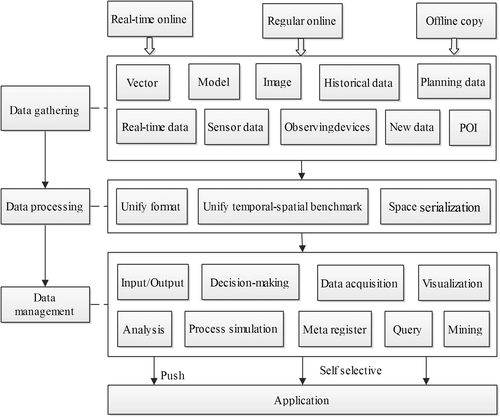
Figure 2. Temporal-spatial management platform.
3. Temporal-spatial big data platform
In the smart city phase, temporal-spatial data include not only different versions of history data but also the location data and streaming data collected by the Internet of Things or an intelligent device. These geographic information data, which have time-stamps, are managed in a unified temporal-spatial big data platform. As shown in Figure , the temporal-spatial information management platform is primarily composed of data gathering, data processing, and data management. Multi-source and multi-heterogeneous structured and unstructured data are gathered, stored, processed, and integrated in this platform.
3.1. Data gathering
For static geographic data (including historical and vision geographic information data), offline copies are entered into a database from the department of surveying and mapping geographic information on a regular basis. For location data and streaming data from the Internet of Things device, the data are appended to a big data center by a multi-level dynamic service via wired or wireless Internet access. Real-time perception data are usually deployed in specific professional departments and their interpretation and metadata are added in real time by push or draw patterns. The source data are invoked as necessary to avoid information overload, which is also known as infobesity.
Structured and unstructured static or streaming data must have time, space, and attribute characteristics. Time indicates the timeliness of data, space represents the space features, and attributes indicate the semantic information. Based on the existing geographic information database, static data information can be updated to temporal-spatial information by expansion and reorganization. For streaming data and multi-level summary data, data are imported in real time.
3.2. Data processing
Data are the core content of urban management. Although these data are employed in a variety of formats, unified pre-processing and fusion are required to satisfy various application requirements. Structured and unstructured temporal-spatial big data, which are presented online in real time, should undergo a serialization process both online and offline. Data processing mainly unifies format, temporal-spatial benchmark, and space serialization.
A unified format refers to different geographic information data that can realize non-destructive format conversion and the topology relation will be established in the conversion process, in which contradictions are eliminated and the data become disorganized. In the process of unifying temporal-spatial benchmark, unifying the space benchmark is conducted first. Data matching and merging methods are employed to realize the multi-scale, vector, and image data update. Then, the time benchmark is unified to ensure the time consistency among different scale data-sets.
Space serialization primarily refers to the establishment of coordinates for the space of structured data by a data matching method. The main process is as follows: (1) Gazetteer feature extraction: some data with spatial coordinate information can be integrated by geometry matching (Mostern and Johnson Citation2008). For data without coordinate information, the property contains the address. Part of the data only contains some place names. Based on semantic and geographic ontology cognition, the place name feature can be extracted by combining Chinese word segmentation and data comparison. (2) Data matching: for data with spatial location information, it can be performed by geometric feature matching (Liu, Zhang, and Gong Citation2014). For thematic information, according to the segmentation of gazetteer identification and based on ontology and word similarity, a local fuzzy method is used to achieve efficient, accurate, and practical gazetteer matching (Janowicz and Kessler Citation2008). (3) Relying on the temporal-spatial benchmark, a name/address positioning and geometry matching method accomplishes the ordering and unstructured information processing.
3.3. Data management
Temporal-spatial data management primarily includes dynamic big data acquisition, analysis, and visualization, analog inference, and data mining. Data management tools can support data input and output, editing and processing, query, statistics, visualization, dynamic update, history data management, meta-data management, and security management. It supports different types of data fusion, long phase comparisons, and change information extraction, as well as the superposition of temporal-spatial data classification, space-time analysis, time series analysis, and forecasting analysis.
To satisfy the application requirements of smart city, a data management platform should also support analog inference and big data mining. Analog inference includes temporal-spatial process simulation and a decision-making plan. Taking an event or situation as the object, space-time process simulation retrieves the related corresponding geographic object and the time, space and attribute content to realize the digital representation of scenes and events. By adjusting the main parameters, the decision-making plan of dynamic inference or manual intervention calculates the effects. Big data mining primarily employs a historical reasoning method, decision tree and genetic algorithm, cluster analysis, connection analysis, online analytical processing, neural network, discriminant analysis, and logical analysis, and then support vector machine, and Bayes’ theory to perform an analysis of data mining tools and enable big custom routing data mining ability.
4. Temporal-spatial cloud service platform
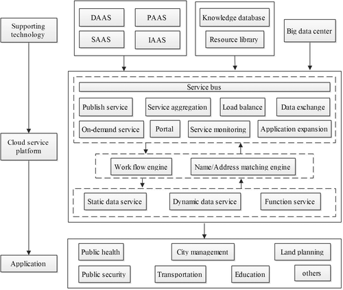
Smart city temporal-spatial information cloud platform (referred to as the cloud platform) employs a ubiquitous network, sensing devices, and intelligent computing to collect various types of temporal-spatial information and form perception in real time. It is an important spatial information infrastructure for smart city construction, with which the decision-making is more intelligent and broader, and the information service is more spiritual, safer, and more reliable. A temporal-spatial information cloud platform uses cloud computing technology to provide geographic location data and interpret perception, function, and development service.
As shown in Figure , the cloud platform contains the basic capabilities, such as Software as a Service (SASS), Platform as a Service (PASS), and Infrastructure as a Service (IAAS). With a knowledge database and resource library at its core, a cloud services system is constructed using a service bus with name/address matching and business flow engine to provide on-demand services for all types of business applications. Based on an existing geographic service platform, the cloud service system expands the elastic distribution of the computing and storage capacity by adding the common sensor access service, intelligent interpretation service and space-time analysis, and a simulated deduction service. In addition, the place/name address matching and business flow engine are added to the application. This section focuses on static geographical information data, dynamic data service, function service, a data matching engine, and a work flow engine.
Figure 3. Temporal-spatial cloud platform.
4.1. Static geographical data service
Static geographical data primarily contains vectors, images, place names, addresses, building models, and other new products. These data are produced and published in the cloud platform in accordance with national standards. These services include web feature services, web map services, web covering services, three-dimensional web model services, three-dimensional terrain data services, three-dimensional texture services, and address geocoding services.
4.2. Dynamic real-time data service
In smart city, a ground acquisition system (such as Radio Frequency Identification, cameras, and environmental sensors) and satellite technologies are combined to form a longitudinal three-dimensional cover and a horizontal comprehensive seamless sense perception network. A cloud platform provides dynamic accumulation of streaming data and a multi-level dynamic data service (Gong and Wang Citation2013).
| • | Real-time location service | ||||
A TSII accesses sensor network data, which has the ability of spatial orientation, to provide real-time location services for different users. The infrastructure (1) integrates the continuous running satellite positioning service into a cloud platform and provides a controlled and authorized rear differential GPS network service that is based on wired and wireless networks; (2) incorporates the existing digital observing systems into a cloud platform and provides real-time data services to update historical geographic information; (3) provides real-time location information and map-matching services.
| • | Streaming data and multi-level summary information | ||||
| (1) | Connect Things IntelliSense location services equipment to access real-time location information. | ||||
| (2) | Connect Things IntelliSense location services equipment to provide streaming data interpretation services. | ||||
| (3) | Multi-level summary data services for streaming data-set. | ||||
| (4) | Push and pull the multi-level summary data and the streaming data sharing services. | ||||
4.3. Cloud management platform
A cloud management platform is the core of the system. Its main tasks are as follows: (1) Integrate the accessed large-scale data-set to provide services for government or industry users. (2) As a basic data exchange platform, developers can employ data aggregation, transformation, processing, and a mining interface to construct their own application systems. In addition to geographic information services (such as data function, interfaces, and features services), it also provides infrastructure services capabilities, on-demand service capacity, and operation and maintenance monitoring capabilities.
Infrastructure services capability: the host system can store the data and related functions to support the end user who is deployed in the cloud environment. Based on the cloud operating system, the related resources are dynamically allocated for high concurrent access, and each user can flexibly mobilize and release the resources to complete a task. A service-hosting environment, which originates from cloud computing centers, is part of the information infrastructure services and provides a unified portal to users via the aggregation service.
On-demand service: provide temporal data acquisition, perception and location, implement streaming data interpretation, develop interface and map features services, and use professional feature signature and knowledge databases to develop a certain learning capability knowledge engine. Based on natural language or main information in a human–machine collaborative environment, the end user can automatically or intelligently assemble and provide services on demand.
Operation monitoring: the system should include platform settings, user management, business review, Internet monitoring, resource hosts, resource publishing, and other capabilities. The user can modify the basic information, database information, and server information. User management consists of the list of users, user group management, role management, and audit approval.
4.4. Data match engine
As a bridge between the spatial information and other information, name/address matching engine is used to precisely position and help users to integrate thematic information (Butenuth et al. Citation2007; Devogele, Parent, and Spaccapietra Citation1998). By the geometric and semantic matching method, large various sources of non-spatial data are integrated and analyzed to provide location business services (such as navigation).
4.5. Work flow engine
In accordance with the logic and rules, work flow is a model that properly represents the entire work process, automatically calculates its implementation, and helps the user to customize the thematic system (Emmerich et al. Citation2007).
Rules library management primarily includes a predefined standardization rules module and its flow relationship, predefined process examples, and existing business processes, such as sample storage, analysis, edit, and return operations. Run service management consists of business process loading and interpretation, service instances creation, such as run, suspend, and resume, terminate instance, and data calls. Run monitoring consists of log monitoring services, graphical operation monitoring, real-time operation tracking service, and service instance state controlling.
5. Application
In the process of TSII construction, which adheres to the demand- and problem-oriented, livelihood issues, information sharing and business integration should be emphasized. A variety of construction and operation models exist, such as the PPP model, which can be employed by application sectors and jointly implemented with cloud platform construction and city maintenance companies. We introduce an application of TSII, which is constructed by the Xicheng District in Beijing.
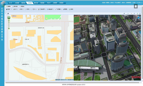
By conducting a temporal database, temporal-spatial information cloud platform, supporting environment improvements, the Planning Bureau in Beijing uses cloud computing, database mining and networking technologies to construct a TSII to provide spatiotemporal big data management and service. The entire solution consists of a big data management platform, a cloud service platform, and numerous applications. The interface of the cloud platform is shown in Figure .
Figure 4. Main interface of platform.
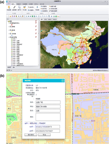
The multi-source data are unified and managed by a big data management and service platform and the new data are imported, exported, and integrated into this platform. Figure (a) shows the main interface of the platform, and Figure (b) shows a data matching process. The non-spatial data might be mistaken for location information, thus, the integration and analysis are unified in the application. The user can match the plurality of address information every time.
Figure 5. Main interface of big-data platform: (a) data visualization; (b) data matching.
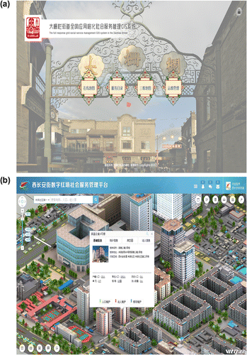
This system is extensively applied in public security, planning, land, transportation, environmental monitoring, social management, national parks, and other fields. Based on the temporal-spatial information intelligent assembly services of the cloud platform, a social service response management GIS system is developed in Figures (a) and (b).
Figure 6. Smart service systems: (a) Dashilar Street; (b) West Chang’an Avenue Redwall.
6. Conclusions
To improve smart city construction, the Chinese State Bureau of Surveying and Mapping Geographic Information has promoted TSII construction in many cities. Aiming at reducing the construction costs, the existing achievement of the geo-spatial framework in digital city needs to be completely utilized. This paper proposes the concepts, main technologies, and framework of TSII and provides guidance and inspiration for people and companies in the process of TSII construction.
Funding
This study is supported by the Fundamental Research Project of the Chinese Academy of Surveying and Mapping [grant number 7771520].
Notes on contributors
Chengming Li is a researcher of the Chinese Academy of Surveying and Mapping. His research interests include smart city, cartographic generalization, and geographic information engineering and applications.
Po Liu is an assistant researcher of the Chinese Academy of Surveying and Mapping. His research interests include virtual geographical environments, geographic information engineering and applications.
Jie Yin is a researcher of the Chinese Academy of Surveying and Mapping. Her research interests include cartographic generalization and geographic information engineering.
Xiaoli Liu is an assistant researcher of the Chinese Academy of Surveying and Mapping, Her research interests include smart city, geographic information engineering and applications.
References
- Butenuth, M., G. V. Gösseln, M. Tiedge, C. Heipke, U. Lipeck, and M. Sester. 2007. “Integration of Heterogeneous Geospatial Data in a Federated Database.” ISPRS Journal of Photogrammetry and Remote Sensing 62 (5): 328–346. doi:10.1016/j.isprsjprs.2007.04.003.
- Devogele, T., C. Parent, and S. Spaccapietra. 1998. “On Spatial Database Integration.” International Journal of Geographical Information Science 12 (4): 335–352.10.1080/136588198241824
- Emmerich, W., B. Wassermann, B. Butchart, N. Cameron, L. Chen, and J. Patel.2007. “Workflows for E-Science: Scientific Workflows for Grids.” Edited by Taylor, I. J., E. Deelman, D. B.Gannon, and M. Shields. Springer-Verlag: London. doi:10.1007/978-1-84628-757-2.
- Gong, J. Y., and G. L. Wang. 2013. “From Digital City to the Smart City: New Challenges to Geography Information Technology.” Journal of Geomatics 38 (2): 1–6. doi:10.14188/j.2095-6045.2013.02.001.
- Janowicz, K., and C. Kessler. 2008. “The Role of Ontology in Improving Gazetteer Interaction.” International Journal of Geographical Information Science 22 (10): 1129–1157. doi:10.1080/13658810701851461.
- Li, C., X. L. Liu, J. Liu, and X. Mao. 2013. “Investigation and Practice of Digital City to Smart City.” Surveying and Mapping Review 1 (3): 1–3.
- Li, D. R., Z. F. Shao, and X. M. Yang. 2011. “Theory and Practice from Digital City to Smart City.” Geospatial Information 9 (6): 1–5.
- Li, D. R., Z. F. Shao, and X. M. Yang. 2012. “The Concept, Supporting Technologies and Applications of Smart City.” Journal of Engineering Studies 4 (4): 313–323.
- Liu, P., J. H. Gong, and M. Yu. 2014. “Graphics Processing Unit-Based Dynamic Volume Rendering for Typhoons on a Virtual Globe.” International Journal of Digital Earth 8 (6): 431–450. doi:10.1080/17538947.2014.915349.
- Liu, P., J. H. Gong, and M. Yu. 2015. “Visualizing and Analyzing Dynamic Meteorological Data with Virtual Globes: A Case Study of Tropical Cyclones.” Environmental Modelling & Software 64: 80–93. doi:10.1016/j.envsoft.2014.11.014.
- Liu, P., Y. Zhang, and J. H. Gong. 2014. “Root Mean Square Error and Neighbouring Relation Matching Approach for Multi-Scale Areal Feature.” Acta Geodaetica Et Cartographic Sinica 43 (4): 419–425. doi:10.13485/j.cnki.11-2089.2014.0062.
- Mostern, R., and I. Johnson. 2008. “From Named Place to Naming Event: Creating Gazetteers for History.” International Journal of Geographical Information Science 22 (10): 1091–1108. doi:10.1080/13658810701851438.
- Sui, D. Z. 2011. “Introduction: Strategic Directions for the Geographical Sciences in the Next Decade.” The Professional Geographer 63 (3): 305–309. doi:10.1080/00330124.2011.566508.
- Wang, J. Y. 2014. “Big Data in the Era of Smart City.” Science of Surveying and Mapping 39 (5): 3–7.
- Wang, J. Y., C. Li, Z. Xiong, and Z. G. Shan. 2014. “Survey of Data-Centric Smart City.” Journal of Computer Research and Development 51 (2): 239–259.