
Abstract
The paper aims to present a concise overview of the current status of the national spatial data infrastructures (SDI) of the European Union (EU) member states combined with specific peculiarities for Bulgaria. Some major challenges within the progress of the EU SDIs establishing, which is regulated by the European Directive INSPIRE (Infrastructure for spatial information in Europe) toward establishment of a SDI for environmental policies and activities, are marked out. Available comparative analyses of the main indicators for metadata, data-sets, and data services provided by EU member states are briefly discussed as a special attention is given to the Bulgarian progress. Recent achievements on accelerating the process of implementing the recommendations of the INSPIRE Directive in Bulgaria are outlined.
1. Introduction
Spatial data infrastructure (SDI) is an institutional concept aiming to better respond to the needs of society for geo-spatially referenced information in various problem-solving domains. This concept continuously evolves and it becomes a core information infrastructure supporting a broad spectrum of social and economic policies of the governing institutions in the countries worldwide. The development of SDI contributes to the efficient management and usage of spatially referenced geographic data and related information for broad spectrum of human activities in public sector − good governance, promoting economic growth, and sustainable resource management (Williamson, Rajabifard, and Feeney Citation2003). After SDI was coined in 1993 as a term by the US National Research Council, it became one of the most critical elements underpinning the decision-making process in many domains and disciplines, including the developing of various applications for all levels of government. In fact, the creation of a National Spatial Data Infrastructure (NSDI) in the USA began after the Executive Order 12,906 of the US President William Clinton (Clinton Citation1994). The NSDI and SDI definitions have evolved over time (NRC Citation1993; OMB Circular A-16 Citation2002; Nebert Citation2004; Craglia and Annoni Citation2007; Dessers Citation2013). Most frequently, SDI means “relevant base collection of technologies, policies, and institutional arrangements that facilitate the availability of and access to spatial data” (Nebert Citation2004). SDI should provide an institutionally sanctioned, automated means for posting, discovering, evaluating, and exchanging geospatial information by participating information producers and users.
The establishment of NSDI foresees the maintaining a quick access to, sharing and exchange of geospatial information to support more effective action in all spheres of the public life. With the advances in information and communication technologies, the people can access the geospatial data remotely. In 2001 (EC Citation1995), the European Commission (EC) launched the SDI initiative, thereby beginning the development of SDI in Europe. It was followed by a proposal for a directive of “Establishing an infrastructure for spatial information in the Community (INSPIRE)”, which was adopted by the EC, the Parliament and the Council and entered into force on 25 April 2007 (EC Citation2007). From a multidisciplinary perspective to use efficiently and effectively the geographic information, the INSPIRE Directive, as a legal act of the EU, sets a minimum EU standard that should be applied at national level. According to the EU definition, a pan-European SDI means metadata, spatial data-sets (as described in Annexes I, II, and III of the directive) and spatial data services; network services and technologies; agreements on sharing, access, and use; and coordination and monitoring mechanisms, processes and procedures, established, operated, or made available in accordance with this directive. INSPIRE builds on the infrastructures for spatial information that have already been created by the member states. Although the SDI building initiatives use European and similar international technologies and standards, their diverse peculiarities reflect different traditions, cultures and socioeconomic models, as well as the different ways in which geospatial data are managed in the particular countries (Craglia and Annoni Citation2007; Masser and Crompvoets Citation2015).
The purpose of the INSPIRE is to enable the formulation, implementation, monitoring activities, and evaluation of Community environmental policies at European, national, and local level, and to provide publicly accessible information. One of the biggest benefits of the EU SDI is an improvement in the functioning of the public administration at all levels by facilitating the administrative access to geospatial information. The departure from the existing business model and national practices based on the sales of maps and data and the lack of a complete policy framework are the reasons why these benefits would be difficult to achieve in the short term. The INSPIRE Directive Implementing Rules are relevant to the European initiatives such as e-Government and the EU interoperability framework. INSPIRE aims until 2020 to make harmonized high-quality geographic information readily available to support environmental policies along with policies or activities which may have an impact on the environment in Europe.
This study aims to provide an overview of the recent achievements of 28 EU member states in establishing NSDIs based on the national progress reports at every three years and yearly indicators’ reports starting from 2010 (Masser and Crompvoets Citation2015). Attention is paid also to the official reports of the EC INSPIRE working group and to relevant general statistics of quantitative indicators developed to identify the regional peculiarities, and different strengths and gaps in the implementation and performance of the directive. In fact, the differences that have become clear by those comparative studies can be referred to the political, legal, organizational, and cultural differences between the EU member states. Human and financial resources of each member state have proven to be the main factors for the current status of the directive implementation. Another major topic of this paper is a proposal for building a general model of an SDI for Bulgaria, considering the major advantages of already established good practices worldwide. The SDI framework is proposed to be included as a major priority in the strategic program for implementing of the recently established e-Government State Agency in Bulgaria (in the mid-2016). General recommendations concerning the improvement of the coordination between all interested parties in the SDI development and usage on national and sub-national levels are proposed in relation with the elaboration of relevant strategy and appropriate action plan.
2. Establishment of national SDI
SDI provides a basis for spatial data discovery, evaluation, and application for users (Rajabifard and Williamson Citation2001, Citation2002; Groot and McLaughlin Citation2000; Crompvoets and Bregt Citation2003; GSDIA Citation2012). The SDI concept, to a certain extent, includes the development of strategic national mapping and spatial data activities organized to meet planning and management needs of each country. The major objectives of the first generation SDI initiatives were summarized in 1998, when Masser (Citation1998) described the SDI related to promoting economic development, stimulating better government, and fostering environmental sustainability. According to SDI Cookbooks (http://gsdiassociation.org/), SDI is used to denote the relevant base technologies, policies, and institutional arrangements. NSDI is a vital platform for the sustainable development and contributes to the improvement of national economy and security, and to better management of environment and natural resources (Rajabifard, Feeney, and Williamson Citation2003; Kok and van Loenen Citation2005).
Recently, three generations of SDI development and implementation are considered by the scientific community: (i) data-centric, (ii) process-centric, and (iii) user-centric (Sadeghi-Niaraki et al. Citation2010). The first generation is connected to the countries which began developing SDI and such model contains definition, collection, and integration of data, as well database creation and implementation. Three main players are defined in first SDI generation: national government, state/local government, and private sector. The second generation is connected to the further SDI development, including knowledge infrastructure, capacity building, communication, and coordination. The second SDI generation is focused on users’ needs, use of data and data applications. The year 2000 is considered as a transition point to the second SDI generation. The third generation is a prominent shift from passive role of the users into their active role based on the preferences to increase user’s satisfaction in a spatially enabled society.
Various approaches about SDI were developed and adopted toward the phased implementation of SDI over the last decade worldwide. Depending on the level of SDI establishment − organizational, local, national, regional, or global – a broad spectrum of issues, related to details of the spatial data, institutional arrangements, and realization stages can be considered. Different progress level has been observed in USA, Australia, Canada, and European countries, taking into account the following overall criteria: objectives, coordinating bodies, resources, role of industrial organizations, data availability, and the emergence of new types of organization (Masser Citation2002, Citation2005; Crompvoets et al. Citation2004). At present, the USA, Australia, and Canada are recognized as leading countries in the SDI establishment and development. But there are some differences in the NSDI development between countries around the world, e.g. Australia is more advanced spatial Enabled Society, the USA develop better spatial data. SDI is understood and described differently by stakeholders from different disciplines and different jurisdictional levels. The comparative study of the experience in SDI establishment in Asia-Pacific, Australia, North America, and Europe has indicated that creating SDI is not possible without the active participation and leadership of the national governments (Rajabifard et al. Citation2006, Citation2012). Most of the initiatives are led by national data producers and this is particularly the case in the central and eastern European countries. It is important to use all possible tools to emerge the SDI progress as different SDI initiatives for all generations of SDI development, various levels in the SDI hierarchy, proactive role of sub-national governmental institutions, and private sector.
We fully support the idea that particular emphasis on facilitating the process of decision-making at the community level in the national context has to be placed in view of the implications for the future SDI development, including the delivery of a virtual world. The USA provides some good practices that might be adopted by other countries, where 13 USA organizations are members of the Coalition of Geospatial Organizations (COGO Citation2015). COGO co-involves state, regional, and local agencies working together with the private and academic sectors to develop NSDIs. These joint efforts are based on four common principles formulated to help the participating parties to create and to guide the NSDI’s development: (i) widely available data; (ii) easy accessing spatial data; (iii) flexible NSDI that is not dependent on current technology, data, or organizational structure; and (iv) the NSDI is a foundation to foster new applications, services, and industries.
The SDI establishment and development processes in Europe are regulated by the INSPIRE Directive (EC Citation2007, Citation2008). The implementation of the INSPIRE Directive has started in a complex environment, characterized by different levels of preparedness across the EU, which affects compliance with the recommendations, technical specifications, and timeframes of the roadmap from each member state. INSPIRE Directive requires integration of different type of data (cadastre, transport, hydrography, protected sites, geological, land cover and land use, soil, environmental, agriculture, population, natural risk zones, meteorological, etc.) divided on 34 themes in the three Annexes. All these data can be used coherently, independent of service (EC Citation2007; Tóth et al. Citation2012).
3. Progress of the INSPIRE Directive implementation
The EU countries encountered many obstacles and shortcomings in the last decade after adoption of INSPIRE Directive by the EC in 2007 (EEA Citation2014; COM Citation2016). INSPIRE covers all the European countries. Different strategies of SDI implementations have been elaborated, thus each country is given the opportunity to choose its own, most suitable way for developing. The documents are prepared in more than 24 languages; hundreds of national experts are involved in developing the technical specifications; standards are distributed in multilingual settings (Craglia Citation2010). The full implementation of the directive into effect in Europe presupposes common implementing rules to be established for specific areas, which are legally binding in their entirety.
The monitoring of the SDI implementation and usage in the EU member states is governed by two sets of rules on a permanent basis according to the INSPIRE Directive. The first set is based on performance indicators, which are derived from a list of developed spatial data-sets with relevant metadata and services. These indicators are submitted by the member states on an annual basis. The second set of indicators comprises qualitative information on the implementation progress in form of the written reports, submitted every three years. These reports include information on the following five major items: (i) coordinating structures, (ii) functioning and coordination of the infrastructure, (iii) use of the infrastructure for spatial information, (iv) data-sharing agreements, and (v) costs and benefits of implementing the INSPIRE Directive.
The progress in NSDI development can be monitored on the basis of various factors, e.g. political, technical, institutional, and conceptual or others. Many authors tried to assess SDIs applying different approaches varying from their description, legal or organizational aspects (Annoni, Craglia, and Smit Citation2002; Masser Citation2002, Citation2005), even some of them have developed a stress test methodology (e.g. Nushi, Van Loenen, and Crompvoets Citation2015). In Europe, Austria, Germany, Finland, France, Italy, the Netherlands, Poland, Portugal, and the UK are among the leading countries in the SDI development (EEA Citation2014; Masser and Crompvoets Citation2016). Crucial aspects from organizational perspective in NSDI development are the existence of a vision, leadership, communication strategy, coherence, and intention of the geographic community to initiate new innovations. The development stage and as a result, the success in SDI establishment as a whole, is determined by the extent to which in the SDI initiative these aspects are present.
The INSPIRE monitoring, which is performed by the EC, has shown that the implementation of this directive in the majority of member states does not proceed smoothly (BE INSPIRE-action plan 2016–2020 [Citation2016]). Some delay in meeting the major milestones of the INSPIRE roadmap have been observed. In 2013, a Group for INSPIRE Maintenance and Implementation was set up and its proactive role led to significant changes in the monitoring process. All the efforts in the INSPIRE Directive monitoring and implementation in the recent few years were focused on the improvement of the coordination of the activities and structure of the progress reports at national level. Recent results regarding the advances of the INSPIRE implementation and fine-tuning necessary to fully meet the initial objective of creating SDI in Europe have been published in the mid-term evaluation report prepared by the INSPIRE team for the EC in 2014 (EEA Citation2014). The main conclusions of this assessment indicate that INSPIRE implementation has reached its half way stage with generally positive outcomes. Since September 2016 the last results from the national monitoring are accessible through the INSPIRE geoportal (http://inspire.ec.europa.eu/). Some countries had submitted their own roadmaps and action plans setting out their strategies for the period up to 2020. Relevant information on the EC reports, the Regulatory Fitness (REFIT) programme’ evaluation, the status of the directive implementation in the EU member states, EFTA members and non-member states is also provided by the Official Journal of the EU (http://eur-lex.europa.eu/). It becomes clear that the INSPIRE Directive is still largely fit-for-purpose, but further efforts are needed at the EU and member state level to close the significant implementation gaps and to harvest the benefits of the directive. Currently, the SDI advancing indicates that SDIs have their role in the contemporary general information structures. Two advanced approaches for INSPIRE qualitative monitoring, suitable for information infrastructure monitoring, are provided by Masser and Crompvoets (Citation2016). Great diversity of approaches for developing and implementing SDI as key elements of the contemporary information infrastructures is used by the INSPIRE participating EU countries.
4. INSPIRE SDI indicators – brief overview
This paper deals with some major indicators (see Table ) used for performing comparative analysis of the quality of metadata (existence and compliance), data-sets (coverage and conformity), and services (discovering, viewing, downloading, transformation, and invoke) provided the INSPIRE, national and other geoportals. The indicators are measured in absolute values or in %. They include already the conformant data-sets and services as well as those that still had to be brought into conformity and reflect the member state’s plans for the INSPIRE implementation.
Table 1. INSPIRE SDI indicators.
We have performed a brief overview of the achievements of 28 EU member states in establishing NSDIs using the national reports and indicators, available on the INSPIRE geoportal (http://inspire.ec.europa.eu/), scientific publications, official reports, etc. A significant progress has been made as regards the spatial data-sets (Annexes I, II, and III) identified and reported yearly by EU member states and especially in the last years (SWD/2016/0243 final, [Citation2016]). The total number of data-sets being reported since 2010–2015 exceeded 95,249 (Figure ). It is obvious that the number of data-sets increased exponentially in the last few years. During the last year of reports, the data-sets increased by a factor of two, compared to the previous reporting period. However, approximately 95% of these data are available for only eight member states. The volume of the spatial data-sets, reported by the other 20 member states, remains relatively stable or even declined in some countries between 2010 and 2015, which is shown in Figure . The observed average number of data-sets is generally low (at less than 200 data-sets per country) compared to better performing countries. Some countries have consolidated many dispersed data-sets into one or few national data-sets, which could be beneficial for the directive implementation. The INSPIRE data for 2015 are shown in Table . Germany, France, Italy, Poland, Spain, and the UK are among the leading countries, which reported the majority of metadata according to their availability and compliance, conformant spatial data-sets for the three annexes, and conformity of network services provided. Very recently, the collected information related to the INSPIRE Directive implementation has become online accessible via the web site https://inspire-dashboard.eea.europa.eu/official/#/, that allows to build dashboards and to monitor the process development in time of the European countries.
Figure 1. Total volume of spatial data-sets (all annexes) reported by EU member states.
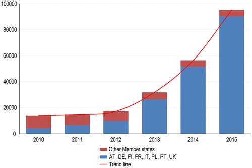
Figure 2. The reported by EU member states spatial data-sets with metadata for the period 2010−2015 (logarithmic scale).
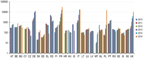
Table 2. INSPIRE data provided by EU member states for 2015.
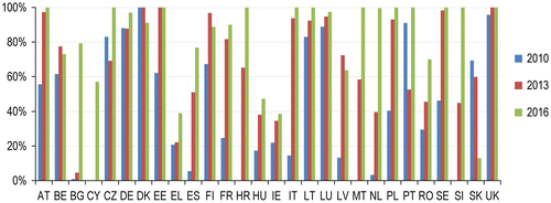
According to the INSPIRE roadmap all digital spatial data-sets falling under the 34 spatial data themes (all annexes) should have been identified, documented, and made available online through services by December 2013. This milestone has not been fully achieved up to the end of 2016. Documenting the identified spatial data with available metadata allows them to be found online more easily. The number of documented spatial data-sets has grown steadily since the first round of national reports in 2010; in the third round (2016) 21 member states had over 70% of their documentation in conformity, while 12 of them had a target of 100% (Figure ).
Figure 3. Spatial data-sets with conforming metadata in % for the period 2010−2016.
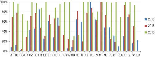
By December 2013, member states also needed to have online services for discovery, view and download in place for all of their documented spatial data-sets. Much better progress in this step has been observed in the last three years. For example, 22 member states met the specified deadline providing view services for 70–100 % of their documented spatial data-sets (Figure ). The situation for download services is also improved, but the expectations as mentioned in SWD/2016/0243 final (Citation2016), are not yet fulfilled. The transformation of spatial data to conform to common data models is also still a challenging task. Member states have to complete this step at the latest by 2020.
Figure 4. Spatial data-sets with view services in % for the period 2010−2016.
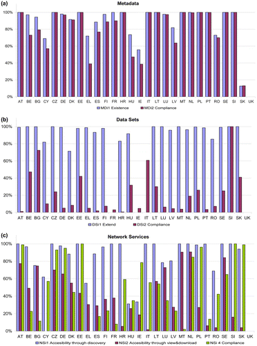
Graphical representation of the 2015-indicators for metadata (MDi1, MDi2), data-sets (DSi1, DSi2), and network data services (NSi1, NSi2, NSi4) from the last national reports of the EU member states is shown in Figures (a), (b), and (c), respectively. The UK does not collect the information related to the usage of spatial data, statement that a data-set is compliant with the directive requirements, issue whether a particular data-set is linked to the network services, area of coverage due to constraints on the UK Lead Government Department, and UK data publishers. Most of the countries have reported the existence and conformity of metadata for spatial data-sets, but some metadata records for spatial data-sets for 12 member states are still not fully compliant with the metadata regulation (Figure (a)). Prevailing part of the relevant data-sets according to their geographical coverage exceeded 80%, while their compliance with the data specifications is less than 40% for most of the countries (Figure (b)). Only Sweden reported about 100% of the INSPIRE-compliant data-sets for 2015. The data-sets are accessible through the discovery services and significant parts on them are in conformity to the implementing rules on network services. Only eight countries have more than 60 % of the services compliant with the implementing rules for view and downloading of the spatial data, as can be seen in Figure (c). The 2016 monitoring results indicate considerable improvements in availability and conformity of the metadata and the spatial data-sets in most of the EU countries as may also be seen on the web site https://inspire-dashboard.eea.europa.eu/official/#/. The published national reports have shown the capacity of the separate countries in EU at 2016 to implement in practice the recommendations of the INSPIRE Directive. The general conclusion, that can be made at the end of 2016, is that the INSPIRE roadmap that posts the main temporal boundaries for concrete results at the beginning of directive implementation, is unlikely to be accomplished by 2020.
Figure 5. SDI indicators of EU member states for 2015: (a) metadata; (b) data-sets; (c) services.
5. Establishing national SDI in Bulgaria
The stages of developing a national SDI model vary among the countries and depend on their initial background and needs. However, it is important that countries follow the INSPIRE roadmap for the SDI implementation in practice. In Europe, most countries are in the process of developing SDIs at national and/or regional/local level and all have started from a different initial stage (see e.g. Annoni, Craglia, and Smit Citation2002; Craglia et al. Citation2002; EEA Citation2014). In the case of Bulgaria, some specific peculiarities can be noted. The creation of digital spatial data in Bulgaria began in the twentieth century with the adoption of a regulation for the development of cadastral plans of settlements. Later, with the application of the restitution laws, many settlements have been fully covered by maps in digital form (Pashova and Bandrova Citation2013, Citation2014).
The process of the implementation of INSPIRE Directive depends on the concerted actions of the governmental institutions with active participation of all other interested parties from the public and private sectors. This process would be developed successfully if there is available a national strategy or action plan, legal frameworks, human and financial resources. Various stages of the INSPIRE Directive envisaged in the European roadmap are not fully realized in Bulgaria for a number of reasons, including legislative, institutional, organizational, and financial aspects. In the last two decades, ministries, municipal governments, research institutes and universities, NGOs, private companies, and other institutions in the country have used the EU funds for realization of many projects related to the geospatial data as main component of the NSDI, following the strategy “bottom-up”. Even now, publicly available information about the stakeholders involved in the building of NSDI, including a description of their roles, how they co-operate, how they share data/services and how to gain access the services via the national INSPIRE geoportal is missing.
The Law on Access to Spatial Data (LASD), which transposed the provisions of INSPIRE Directive in the Bulgarian legislation (State Gazette, N19 Citation2010), was adopted in 2010. This is a strategic document for Bulgaria that regulates the establishment, maintenance, and operation of a NSDI, providing access to the spatial data and service in the field of environment. An important element of the NSDI is the national geoportal, which has to link with the EU INSPIRE geoportal. It is worth to mention that in accordance with the national legislation, the Ministry of Transport, Information Technology and Communications (MTITC) determined and coordinated the coherent national policy for building the SDI until mid-2016. The Executive Agency “Electronic communication networks and information systems” (EAECNIS) at this Ministry was the responsible coordinating structure for construction of the national geoportal and its maintenance. Bulgaria, together with Malta, differs from the rest EU member states since the state institution responsible for the implementation of INSPIRE Directive does not match the geodetic or mapping institution nor the relevant ministry, which is responsible for policies on the environment (SWD/2016/0243 final [Citation2016]).
Even after the adoption of LASD in 2010 the process of creating the Bulgarian SDI was not accelerated compared to other European countries. For overcoming the significant delays of the country in the implementing of the INSPIRE Directive, some particular proposals and measures aimed at the improvement of the organizational structure have been suggested by Pashova and Bandrova (Citation2013, Citation2014). Those suggestions have achieved the expected impact − they are used by responsible state institutions in the follow-up undertaken activities as initial steps to accelerate the process of establishing NSDI. One outcome has been that in 2014 the EAECNIS at the MTITC has undertaken actions for amendment of the national legislation and after a year a Law on Amendments to the LASD was adopted (State Gazette, N26 Citation2015). In 2015 the MTITC has initiated changes of the Interagency Council on Spatial Data and organizational restructuring of the EAECNIS. This Council and the Expert Working Group at the Ministry have taken various measures and performed organizational and preparatory activities such as: adopting an action plan to speed up the implementation of Directive 2007/2/EC INSPIRE; identifying the roles of the responsible governmental institutions as primary administrators of spatial data; starting a procedure for the initial functionality provision of the national geoportal; preparing of several projects needed for the organizational planning and the national regulating documents; and conducting a training according to the Law for access to spatial data and the requirements of the directive (National Report of BG Citation2016). Based on the framework agreement between the Ministry of Defence (MoD) and MTITC, the functions of an NSDI geoportal, which provide connectivity with the EU INSPIRE geoportal are performed through the information system for public access to spatial data and services of the MoD. Since the beginning of 2016 Bulgaria guarantees a functional use of the information systems to provide public access to spatial data and services through the web portal http://www.inspirebg.eu/, which is a temporary national portal for SDI connected to the Geoportal infrastructure for spatial information in the EU. It is maintained by the MoD and will function until the establishment of the formal NSDI geoportal. There are published validated metadata on 7 themes (from 34 INSPIRE themes) and the access to network services is free without restrictions. The available network services are: (i) discovery services (“finding”); (ii) view services (“consideration”), and (iii) download services (“withdrawal”).
The UN report “E-Government Survey 2016” shows Bulgaria to be in 52nd place out of 193 countries (https://publicadministration.un.org). The estimates for Bulgaria in all indicators (online services, telecommunications, infrastructure, and human capital) are lower than the average for the European region despite some recent improvements. Full integration of data administration and complete interoperability between existing and building information systems is not yet achieved. There is a partial connectivity between the electronic registers of public administration as the access to spatial data is rather limited (MTITC Citation2014). In the last years, several national strategic documents were adopted by the Bulgarian Government. One of these documents is the Strategy for electronic management development in the Republic of Bulgaria, 2014–2020, which aims at developing and improving the efficiency of administrative governing processes by providing e-services. This strategy is also consistent with the policies of several crucial documents such as National development program “Bulgaria 2020”; National program “Digital Bulgaria 2015”; Declaration of the Ministers responsible for policies on e-government; Strategy “Europe-2020”; DIGITALEUROPE, and some others.
In June 2016, the Parliament of Bulgaria approved government plans for setting up a new e-Government agency. This state agency will be responsible for implementing the state policies for e-Government, e-Certification services, e-Identification, network and information security, and spatial information. The governmental policy and activities in the construction, maintenance, and use an NSDI will be coordinated by the Chairman who will be assisted by the Directorate “Information systems and interoperability”. The Directorate will establish and maintain a single portal for access to electronic administrative services and open data portal for the access to public information. The e-Government agency is expected to start operations in early 2017 and to implement all activities, including those related to the NSDI and geoportal under the new political conditions in the country.
Despite the results achieved over the past 2–3 years in the implementation of INSPIRE Directive, there is still room for improvement, particularly regarding institutional, technical, and organizational measures and activities for acceleration of the whole process. The national policies and the human and financial resources have also a significant role to overcome the serious delays of Bulgaria in the implementation of the INSPIRE roadmap and building the NSDI. In this regard, a conceptual framework of a national SDI model that is suggested for Bulgaria is shown in Figure . The proposed SDI model encompasses different categories of components which can be formed based on the variety of interactions within the SDI framework, irrespective of its level of establishing – governmental, local, or private. SDI can be defined as an infrastructure, which encompasses two main categories: (i) the human resources and the spatial data are considered as one category; (ii) the second includes policies, standards, and networks as key technological components (Rajabifard and Williamson Citation2002).
Figure 6. Conceptual NSDI Model for Bulgaria ( Adapted by Rajabifard Citation2002; Nushi, Van Loenen, and Crompvoets Citation2015).
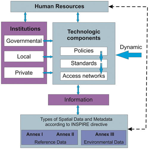
The SDI conceptual model includes human resources (providers and users), SDI components, and spatial data-sets as core elements of NSDI. This model includes policies, standards, and access network, which are key technologic components of the SDI (Rajabifard and Williamson Citation2002; Nushi, Van Loenen, and Crompvoets Citation2015). The processes and relationships between data providers and users have become increasingly transparent. Sharing of simplified forms of data (Information) instead the raw data forms accelerates the free access to spatial data at different level of governing. This SDI model of information access and will require the use of institutional mechanisms (Institutions) that support the availability and access to data through the information and technologies components. The rights, restrictions, and responsibilities between people and spatial data change are needed to mediate regularly due to the dynamic character of the technologic components’ development. There are already some geoportals in Bulgaria that provide access to spatial data at national level and an exemplary list was published in 2013 (Pashova et al. Citation2013). The successful implementation of the proposed SDI model in Bulgaria depends on the guiding role of the new e-governmental state agency. SDI operation plan is based on the required action dynamic approach. Within the feasible SDI development some activities can be implemented together. Since the SDI development is essentially a long-term project and country’s status is always changing, the specific duration of different stages of INSPIRE implementation in Bulgaria is also difficult to be determined due to the evolving nature of the SDI platform over time. An action plan to speed up the implementation of INSPIRE Directive in Bulgaria is provided in the last national report for 2016, which is available on the EU INSPIRE geoportal. It includes four stages: (i) immediate actions − up to 31 August 2015; (ii) short-term actions − until the middle of 2016; (iii) medium-term actions − by the end of 2017; (iv) long-term actions − by the end of 2020. The achieved results up to mid-2016 are summarized by Danailova, Markov, and Gladkov (Citation2016). Harvesting management for implementation of the INSPIRE Directive at national level can be seen on web address: https://inspire-dashboard.eea.europa.eu/official/#/harvesting/manage. Foreseen activities of the institutions applying the LASD are not met completely according to the preliminary plan and there are still some institutional difficulties. Nevertheless, the Bulgarian SDI roadmap is an important step toward achieving the objectives of the INPIRE Directive and for establishing an NSDI. This roadmap should be applied in practice by executing timely planned activities and the national obligations regarding the INSPIRE Directive as a member state of the EU. Its future development depends on the social-economic, technological, and political conditions in the country. An appropriate example for developing an NSDI, institutional arrangements and technical components as consistency of basic steps is suggested by Alexiadou and Rajabifard (Citation2006) for Greece.
Very recently, Bulgaria undertook several measures to overcome different obstacles and to overcome the serious lagging in the INSPIRE Directive implementation. The problems related to the responsibilities of the governing institutions which are stakeholders of spatial data, to a large extent, are eliminated. The major obstacles to overcome are believed to be not of technical nature, but rather the different standards, work procedures, business models, national legislation, and different practices for spatial data sharing among the institutions in the country and outside. The actions at a national level to promote the sharing of spatial data-sets through the INSPIRE regulated network services will continue under the updated national roadmap.
6. Conclusions
This paper summarizes in brief the current situation with regard to SDI and INSPIRE Directive implementation at European level. The comparative analysis shows that political, legal, organizational, and cultural differences between member states still have significant impact on the activities undertaken to harmonize geographical information on the European continent in support of environmental policies. Recently, some progress in considerable improvements in availability and conformity of the metadata and the spatial data-sets is achieved in most of the EU countries. Much has to be done to attain the geospatial information being accessible and readily available across the European countries. From the spatial science perspective, international initiatives that promote the sharing of spatial data and data integration through the arrangement of people, policies, organizations, and technology, necessary for sustainable management of the natural resources, disaster risk reduction and many other applications are based on SDI established at different levels − from local to global. Developing of SDI requires a delicate balance between public, private, and personal interests while taking into account the complex interplay among technological, legal, economic, and institutional issues in achieving such balance. A collaborative partnerships and joint efforts of many organizations are needed to establish and maintain modern NSDIs as dynamically evolving infrastructures. At the same time new challenges arise of reconciling geospatial data, metadata, and services derived from the international and EU programs and projects related to the environmental monitoring.
Special attention in this paper was given to the spatial activities in Bulgaria; the major problems in developing of NSDI are discussed and an SDI conceptual model is proposed. There is a need for policies, people, advanced technology, criteria, and standards for establishing the NSDI which will promotes the sharing and the effective usage of geospatial data and information among all levels of government and the public concerned. A key element for the successful overcoming the delay in INSPIRE implementation and establishing NSDI in Bulgaria is the formation of a national strategy that reflects the interests of all parties, users and suppliers of geospatial data in accordance with the recommendations of the INSPIRE Directive. Strategic vision to build NSDI is absolutely necessary to achieve interoperability and exchange of geospatial information via the national geoportal. In addition, the government has to develop a benchmarking strategy to monitor SDI progress with corresponding activities at European level. The level of awareness, institutional capacity, and information systems availability can be used as indicators to account a progress in this process. It seems that the quality and position of Bulgarian achievements in INSPIRE at European level will improve in near future.
Notes on contributors
Lyubka Pashova is an associate professor of Geodesy Department at the National Institute of Geophysics, Geodesy and Geography, Bulgarian Academy of Sciences. Her research interests include geodetic and geospatial data processing and analysis. She is a principal investigator in several international and national research projects, and the author of approximately 100 scientific papers in the field of geodesy and cartography.
Temenoujka Bandrova (professor) is the President of Bulgarian Cartographic Association and Head of Laboratory on Cartography, University of Architecture, Civil Engineering and Geodesy, Sofia. Her scientific interests are related to cartography, 3D virtual mapping, map projection, children and school cartography, ecology and cartography, cartography, and GIS for early warning and crises management. She has published more than 100 articles, reports, papers, book chapters, 30 school atlases, and more than 90 wall maps.
Acknowledgments
We would like to thank Dr. Mihaela Kouteva-Guentcheva for her very useful comments and assistance in preparing this manuscript.
References
- Alexiadou, S., and A. Rajabifard. 2006. “Developing National SDI Platform for Greece.” Coordinates. http://mycoordinates.org/developing-national-sdi-platform-for-greece/all/1/.
- Annoni, A., M. Craglia, and P. Smit. 2002. “Comparative Analysis of NSDI.” Proceedings of the 8th EC GI – GIS, Dublin, Ireland, July 3–5. http://www.ec-gis.org/Workshops/8ec-gis/cd/papers/4_sdi_aa_1.pdf.
- BE INSPIRE-action plan 2016–2020. 2016. “INSPIRE Action Plan for Belgium 2016–2020.” Geopunt Vlaanderen. http://www.geopunt.be/~/media/geopunt/voor-experts/documenten/inspire-actionplan_2016-2020_belgium.pdf.
- Clinton, W. J. 1994. “Executive Order 12906, Coordinating Geographic Data Acquisition and Access: The National Spatial Data Infrastructure: Washington, DC.” Federal Register 59 (71): 17671–17674.
- COGO. 2015. “Report Card on the U.S. National Spatial Data Infrastructure.” COGO. http://www.cogo.pro/uploads/COGO-Report_Card_on_NSDI.pdf.
- COM. 2016. (478 final/2). Report from the Commission to the Council and the European Parliament on the Implementation of Directive 2007/2/EC of March 2007 Establishing an Infrastructure for Spatial Information in the European Community (INSPIRE) Pursuant to Article 23. http://ec.europa.eu/transparency/regdoc/rep/1/2016/EN/1-2016-478-EN-F1-1.PDF.
- Craglia, M. 2010. “Building INSPIRE: The Spatial Data Infrastructure for Europe.” ArcNews 32 (1): 5–7. http://www.esri.com/news/arcnews/spring10articles/building-inspire.html.
- Craglia, M., and A. Annoni. 2007. “INSPIRE: An Innovative Approach to the Development of Spatial Data Infrastructures in Europe.” In Research and Theory in Advancing Spatial Data Infrastructure Concepts, edited by H. J. Onsrud, 93–105. Redlands, CA: ESRI Press.
- Craglia, M., A. Annoni, R. S. Smith, and P. Smith. 2002. Spatial Data Infrastructures: Country Reports. Sheffield: Geographic Information Network in Europe (GINIE), University of Sheffield. September.
- Crompvoets, J., and A. Bregt. 2003. “World Status of National Spatial Data Clearinghouse.” Urban and Regional Information Systems Association (URISA) Journal 15 (2): 15–22.
- Crompvoets, J., A. Rajabifard, A. Bregt, and I. Williamson. 2004. “Assessing the Worldwide Developments of National Spatial Data Clearinghouses.” International Journal of Geographical Information Science 18 (7): 665–689. doi:10.1080/13658810410001702030.
- Danailova, M., M. Markov, and G. Gladkov. 2016. “Spatial Information Infrastructure − Development and Results in Bulgaria.” Proceedings, 6th ICC&GIS, 551–561, Albena, Bulgaria, June 13−17.
- Dessers, E. 2013. Spatial Data Infrastructures at Work: Analysing the Spatial Enablement of Public Sector Processes. Leuven: Leuven University Press.
- EC. 1995. European Commission, GI2000 − Towards a European Geographic Information Infrastructure (EGII) − A Discussion Document for Consultation with the European GI Community. Luxembourg. Accessed June 19. http://www.ec-gis.org/copygi2000/gi2000/egii_.html
- EC. 2007. “Commission of the European Communities, Directive 2007/2/EC of the European Parliament and of the Council of 14 March 2007 Establishing an Infrastructure for Spatial Information in the European Community (INSPIRE).” Official Journal of the European Union L108: 1–14. http://eur-lex.europa.eu/legal-content/EN/TXT/?uri=OJ
- EC. 2008. “Commission Regulation (EC) No. 1205/2008 of 3 December 2008 implementing Directive 2007/2/EC of the European Parliament and of the Council as regards metadata (Text with EEA relevance).” Official Journal of the European Union 326: 12–30. http://eur-lex.europa.eu/legal-content/EN/TXT/?uri=uriserv:OJ.L_.2008.326.01.0012.01.ENG&toc=OJ:L:2008:326:TOC
- EEA. 2014. Mid-term Evaluation Report on INSPIRE Implementation: Joint EEA-JRC Report. European Environment Agency, Technical Report 17/2014. Luxembourg: Publications Office of the European Union, 92.
- Groot, R., and J. McLaughlin. 2000. Geospatial Data Infrastructure, Concepts, Cases, and Good Practice. Oxford: Oxford University Press.
- GSDIA. 2012. “Global Spatial Data Infrastructure Association.” Spatial Data Infrastructure Cookbook. http://www.gsdidocs.org/GSDIWiki/index.php/Main_Page.
- Kok, B., and B. van Loenen. 2005. “How to Assess the Success of National Spatial Data Infrastructures?” Computers, Environment and Urban Systems 29 (6): 699–717.10.1016/j.compenvurbsys.2004.02.001
- Masser, I. 1998. Governments and Geographic Information. Boca Raton, FL: CRC Press.
- Masser, I. 2002. “Report on a Comparative Analysis of NSDI’s in Australia, Canada and the Unites States.” A report released by Geographic Information Network in Europe (GINIE). University of Sheffield. Accessed October 22. http://www.ec-gis.org/ginie/doc/SDIComparative_report_Final.pdf
- Masser, I. 2005. “The Future of Spatial Data Infrastructures.” ISPRS Workshop on Service and Application of Spatial Data Infrastructure, XXXVI (4/W6): 7−16, Hangzhou, China, October 14–16.
- Masser, I., and J. Crompvoets. 2015. “Implementing INSPIRE in the Member States.” Chap. 4 in Building European Spatial Data Infrastructures, edited by I. Masser. Redlands, CA: ESRI Press.
- Masser, I., and J. Crompvoets. 2016. “Qualitative Monitoring of Information Infrastructures: A Case Study of INSPIRE.” Environment and Planning B: Planning and Design. doi: 10.1177/0265813516675871 ( online published).
- MTITC. 2014. “Strategy for Electronic Management Development in Republic of Bulgaria, 2014–2020.” Ministry of Transport, Information Technology and Communications. https://www.mtitc.government.bg/upload/docs/2014-03/1_StrategiaRazvitieEU_RBulgaria_2014_2020.pdf.
- National Report of BG. 2016. “National Report of Bulgaria.” INSPIRE, May 26. http://cdr.eionet.europa.eu/bg/eu/inspire/reporting/envv0a3cg/INSPIRE_Report_Bulgaria_2016.docx/manage_document
- Nebert, D. D. 2004. “Developing Spatial Data Infrastructures: The SDI Cookbook.” Version 2.0.. GSDI Association. http://gsdiassociation.org/images/publications/cookbooks/SDI_Cookbook_GSDI_2004_ver2.pdf
- NRC. 1993. “Toward a Coordinated Spatial Data Infrastructure for the Nation.” National Research Council, Mapping Science Committee. Washington, DC: National Academy Press. http://www.nap.edu/readingroom/records/0309048990.html.
- Nushi, B., B. Van Loenen, and J. Crompvoets. 2015. “The STIG - A New SDI Assessment Method.” International Journal of Spatial Data Infrastructure Research 10: 55–83. doi:10.2902/1725-0463.2015.10.art3.
- OMB Circular A-16. 2002. Coordination of Geographic Information, and Related Spatial Data Activities, Office of Management and Budget. https://obamawhitehouse.archives.gov/omb/circulars_a016_rev/.
- Pashova L., and T. Bandrova. 2013. “INSPIRE Directive in Bulgaria Until 2013 – Results, Problems and Perspectives”, In Proceedings of SDI & SIM 2013 – International Conference, Skopje, edited by Y. Doytsher, B. Idrizi and C. Potsiou, 149–161. FYRoM, November 13–16.
- Pashova, L., and T. Bandrova. 2014. “Whether Bulgaria Achieves an European Measurable Results in the Application of the INSPIRE Directive.” Geomedia Magazine 1: 38–45 (In Bulgarian). http://www.geomedia.bg/component/flippingbook/book/25-2014-1/8-2014.
- Pashova L., T. Bandrova, P. Kastreva, and B. Idrizi. 2013. “Prospects for the Development of Web Geo-services Between Bulgaria and FYROM by Applying the INSPIRE Directive.” In INSPIRE and Integrated Land & Water Management Scientific Workshop, 71–78. Sibenic: SDI Days 2013.
- Rajabifard, A. 2002. “Diffusion of Regional Spatial Data Infrastructures: With Particular Reference to Asia and the Pacific.” PhD, Department of Geomatics, University of Melbourne, Melbourne. http://csdila.ie.unimelb.edu.au/publication/theses/Rajabifard_PhD_Thesis.pdf.
- Rajabifard, A., A. Binns, I. Masser, and I. Williamson. 2006. “The Role of Sub-national Government and the Private Sector in Future Spatial Data Infrastructures.” International Journal of Geographical Information Science 20 (7): 727–741. doi:10.1080/13658810500432224.
- Rajabifard, A., and D. Coleman. 2012. “Towards Spatial Enablement and beyond.” In Spatially Enabling Government, Industry and Citizens: Research and Development Perspectives, 9–22. Needham: GSDI Association Press.
- Rajabifard, A., M.-E. F. Feeney, and I. Williamson. 2003. “Spatial Data Infrastructures: Concept, Nature and SDI Hierarchy.” In Developing Spatial Data Infrastructures: From Concept to Reality, edited by I. Williamson, A. Rajabifard, M.-E.F. Feeney, 17–40. Boca Raton, FL: CRC Press.
- Rajabifard, A., and I. P. Williamson. 2001. “Spatial Data Infrastructures: Concept, SDI Hierarchy and Future Directions.” Proceedings of GEOMATICS’80 Conference, Tehran, Iran.
- Rajabifard, A., and I. P. Williamson. 2002. “Spatial Data Infrastructures: An Initiative to Facilitate Spatial Data Sharing.” In Global Environmental Databases: Present Situation and Future Directions, Vol. 2, 108–136. Hong Kong: Geocarto International Centre.
- Sadeghi-Niaraki, A., A. Rajabifard, K. Kim, and J. Seo. 2010. “Ontology Based SDI to Facilitate Spatially Enabled Society.” In Proceedings of GSDI 12 World Conference, 19–22. Singapore.
- State Gazette, N19. 2010. “Law on Access to Spatial Data.” N-Lex. http://eur-lex.europa.eu/n-lex/legis_bg/index_bg.
- State Gazette, N26. 2015. “Law on Amendments to the Law on Access to Spatial Data.” N-Lex. http://eur-lex.europa.eu/n-lex/legis_bg/index_bg.
- SWD/2016/0243 final. 2016. Commission Staff Working Document, Executive Summary on the Evaluation of DIRECTIVE 2007/2/EC Establishing an Infrastructure for Spatial Information in the European Community (INSPIRE) and Underpinning the Report on the Implementation Accompanying the Document Report from the Commission to the Council and the European Parliament on the Implementation of Directive 2007/2/EC of March 2007 Establishing an Infrastructure for Spatial Information in the European Community (INSPIRE) pursuant to Article 23. http://eur-lex.europa.eu/legal-content/EN/TXT/?uri=CELEX%3A52016SC0243.
- Tóth, K., C. Portele, A. Illert, M. Lutz, and V. Nunes de Lima. 2012. A Conceptual Model for Developing Interoperability Specifications in Spatial Data Infrastructures. Luxemburg. http://inspire.ec.europa.eu/documents/Data_Specifications/IES_Spatial_Data_Infrastructures_(online).pdf.
- Williamson, I. P., A. Rajabifard, and M. E. F. Feeney. 2003. Developing Spatial Data Infrastructures: From Concept to Reality. Boca Raton, FL: CRC Press.10.1201/9780203485774