Abstract
With the increase of different sensors, applications and customers, the demand from data providers and users is for a new geospatial data service model, which supports low cost, high dexterity, and which would provide a comprehensive service. Based on such requirements and demands, the 21AT TripleSat constellation terminal and data delivery and management system has been developed by a Beijing based high-tech enterprise, Twenty First Century Aerospace Technology Co., Ltd. (21AT). The company is the first commercial Earth observation satellite operator and service provider in China. This new geospatial data service model allows the user to directly access multi-source satellite data, manage the data order, and carry out automatic massive data production and delivery. The solution also implements safe and hierarchical user management, statistical data analysis, and automatic information reports. In addition, a mobile application is also available for users to easily access system functions. This new geospatial solution has already been successfully applied and installed in many customer sites in China, and is now available globally for international clients interested in fast geospatial solutions. It enables the success of customers’ operational services. Besides providing TripleSat Constellation images, the multi-source data access system also allows the users to access other satellite data sources, based on customized agreement. This paper describes and discusses this new geospatial data service model.
1. Introduction
Application of earth observation satellites plays a significant role in supporting national and international economies. So far, there are many Chinese land observation satellites in orbit and in operational service, including the CBERS-02B (China Brazil earth resource satellite), HJ, ZY, SJ, GF, and BJ series, and many others (Xu, Gong, and Wang Citation2014; Zhou, Huang, and Wang Citation2014). According to China’s Middle and Long-term Planning, in decade years, more than 10 land observation satellites will be developed and launched by China, thus forming an integrated land observation system, characterized by a multi-sale spatial resolution and diversified sensors (Yang and Chi Citation2011). In turn, these will obtain plentiful geospatial remote sensing data to apply in many industries such as agriculture, environment, forestry, traffic, and so on. While the number of remote sensing applications has increased greatly, the remote sensing data are still generally considered as a scientific data-set used by specialist organizations and government agencies. Currently, earth observation satellite data are certainly not as popular as data from global positioning satellites, communication satellites, and meteorological satellites. Moreover, the remote sensing satellites applications market is still typified by a lack of sufficient professional commercial services providers who can meet the needs and various demands from the end-users, like satellite planning, imaging, processing, obtaining, visualization, archiving, etc. Hence, it is clear that commercial remote sensing satellite enterprises who best understand the user demands by having close contact with their customers, provide more direct, convenient, and efficient services (Mantas, Liu, and Pereira Citation2015; Tan, Di, and Deng Citation2016).
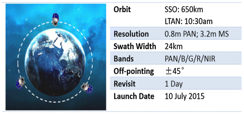
The Twenty First Century Aerospace Technology Co., Ltd. (21AT) is a Beijing based high-tech enterprise and is the first commercial Earth observation satellite operator and service provider in China. In this paper, we present the 21AT TSCT and DDMS. The main satellite data source of the solution is the TripleSat Constellation operated by 21AT, which is a high resolution (<1 m) satellite constellation, consists of three identical satellites, launched on 10 July 2015. The constellation can provide daily targeting capability anywhere on Earth. Both space and ground segments have been designed to efficiently deliver guaranteed timely information. The TripleSat Constellation is the enabler for customers’ operational and sustainable geospatial applications. A diagram of TripleSat constellation satellites in the same orbit is shown in Figure .
This new geospatial data service model allows the user to directly access multi-source satellite data, manage their data order, and carry out automatic massive data production and delivery. The solution also implements safe and hierarchical user management, statistical data analysis, and automatic information reports. In addition, a mobile application is also available for users to easily access system functions.
2. Review
In recent years, remote sensing data have become available from governmental agencies and enterprises because of the ever-increasing technological capabilities of the web (Ji Citation2013; Kang Citation2012; Zhou, Huang, and Wang Citation2014). Several web portals that provide comprehensive service opinions for data search, order, and download are presented below:
| (1) | NASA’s earth observing system data and information system (https://earthdata.nasa.gov/data/near-real-time-data; http://gcmd.nasa.gov/index.html; http://reverb.echo.nasa.gov; https://earthdata.nasa.gov/echo/; https://earthdata.nasa.gov/data/data-tools) has a core capability for exploring and managing multi-source NASA’s earth historical data, which is designed as a distributed system, with major facilities at distributed active archive centers (DAACs) located throughout the United States. | ||||
| (2) | China center for resources satellite data and application (CRESDA) has established a “three-in-one network” data distribution service system to ensure that the rapid growth of satellite data can meet users’ requirements. The data distribution system was transitioned from a single CD-ROM (magnetic media)-based distribution to network-based distribution, followed by a transition from single network to multiple networks, including a special network, the e-government network, and the Internet, at different levels and for different users. | ||||
| (3) | The European space agency’s (ESA) earthnet online portal: this provides services for search and request of EO data from ESA EO Missions (ERS-1, ERS-2, Envisat, GOCE, SMOS, CryoSat, SENTINEL-1, SENTINEL-2, SENTINEL-3), third party missions (TPMs), ESA campaigns, the GMES space component (GSC), as well as sample and auxiliary data from a number of missions and instruments. The data browsing can be performed by mission and instrument, or by earth topic, typology, and processing level (https://earth.esa.int). | ||||
| (4) | The Canadian space agency provides capabilities of searching and downloading open access data which consists of EO data over Canada, such as Landsat imagery. The data search can be performed through free text form and filters by organization, data type, and subject, etc. (http://data.gc.ca/eng). | ||||
| (5) | The national remote sensing center (NSRC) of the Indian space research organization (ISRO) distributes open EO data archive of ISRO’s satellite products (Resourcesat-1: OrthoAWiFS and LISS IIIdata; IMS-1: HySISpectralBinneddata) for India via the Bhuvan geoportal. (http://bhuvan.nrsc.gov.in). | ||||
| (6) | Argentina’s national commission on space activities (CONAE) provides catalog imagery data search under different states of access and download. (http://www.conae.gov.ar/index.php/es/catalogo-de-imagenes). | ||||
| (7) | Brazilian’s national institute for space research (INPE) has a catalog search for imagery products (CEBERS, Landsat, MODIS TERRA, MODISAQUA, Resourcesat-1) and also provides the capability of imagery data acquisition after registration (http://www.dgi.inpe.br/CDSR/). | ||||
In summary, many government organizations and agencies have been providing multi-data products and services for a very long time. However, systems’ service methods place restrictions on historical imagery data or catalog search, order, and download processes. Additionally, such traditional services often lack low cost, high dexterity, and comprehensive application and distribution services, to specifically meet the user’s interest in subscription, independent processing and 3D visualization needs. In particular, remote sensing data distribution is a key component of the whole service, as this directly bridges the gap between the user and the remote sensing data.
The traditional data sales and services of satellite operators in the market are through local partners or resellers. For instance, in 2014, DigitalGlobe had 60% of the world remote sensing data sales market (Wang and He Citation2015). DigitalGlobe has 2 subsidiary companies, 7 sole agents, and 116 international distribution partners. Airbus has about 20% of the market of world remote sensing data sales (Wang and He Citation2015). It has 7 subsidiary companies, 4 sole agents, and 102 international distribution partners. However, as is well known, the disadvantage of this method of selling Earth observation data by means of distributors, is associated with high costs and low efficiency. Nowadays, with the web technology development, users can access the remote sensing data in a faster, more flexible, simple, and cheap way.
When Earth observation spatial data distribution is by means of the web, customers should log into the data service website supported by the data provider, and search data by specific attribute parameters (Ji Citation2013; Mantas, Liu, and Pereira Citation2015; Qian, Sun, and Xu Citation2012; Wang, Li, and Jia Citation2007). Once the relevant data have been found in the database, customers can order the data, which can then be delivered to them by disks, CDs, or direct download from the Internet. Currently, nearly all the leading remote sensing data service platforms around the world implement this model to distribute remote sensing data and provide data services, such as the multi-satellite data service platform operated by the institute of remote sensing and digital earth, Chinese academy of sciences (http://eds.ceode.ac.cn/); the TERRA-MODIS platform from the institute of geographic sciences and natural resources research Chinese academy of sciences; the scientific data platform from the computer network information center (http://www.csdb.cn/), data service platform from the China center for resources satellite data and application (http://218.247.138.121/DSSPlatform/index.html#/); the data service website from US geological survey (USGS)/EDC (http://landsat.usgs.gov/), data service platform from Remote Sensing Technology Center of Japan (http://www.restec.or.jp/english/satellite/index.html), and data service platform from geo-informatics to space technology development agency of Thailand (http://www.gistda.or.th/gistda_n/en/index.php?option=com_content&view=article&id=17&Itemid=27).
At present, due to the rapid increase in the number and types of Earth observation data sources, and the rapid development and prevalence of mobile terminals and wireless networks, these traditional data distribution models have been exposing constraints that hinder the development of remote sensing applications. The institute of remote sensing and digital earth (CAS-RADI) was one of the first organizations to present a location-based instant satellite image service (LBISIS) system which provides LBISIS. By means of this system, users can subscribe to data, based on their location of interest, and subsequently the satellite image data received by the ground receiving station’s antenna will be distributed to the customer’s terminal devices (Liu, Yang, and Chen Citation2014). LBISIS provides instant image services adjoining remote sensing application downstream demands. The main drawback of this system is the lack of instant observing services.
3. User requirements
Based on traditional image storage and management, search and query, order and distribution service methods, a new generation of remote sensing service system is needed, with a structure that will meet higher user demands. From the data provider’s point of view, there are two aspects to take into consideration about developing this new system at low cost (Tan, Di, and Deng Citation2016). Firstly, the new system should have the capability of integrating satellite operations, data receiving, data processing, data dispatch, and other services. Traditionally, the management of satellite observations, processing and distribution are separate issues, and treated separately. This mode of management reduces service efficiency, and is not suitable to meet the need for efficiency. Furthermore, the cost will increase exponentially for the management of mass imagery products, various application requirements, and connect and balance between different departments. Secondly, the new system has a core capability of pliability and expandability to multi-satellite sources, imagery products, and application users. With spacecraft technology development (Hastings, Putbrese, and Tour Citation2016; Kang Citation2012), more quantity and type of satellites will be available. For taking full advantage of satellites sources, it is a requirement for remote sensing data service systems to support satellite dynamic increase and overall management. Then different sensor satellites produce new standard imagery other than existing product, therefore, the design of structure must have the ability to extend other sensor standard product. The increase in quantity and type of product attract application users, and then the size of system, which is the core of sharing data, can be extended.
From a data user’s perspective, there are three important aspects of the system that users really need, namely: it should be real time, enable multi-terminals to be used simultaneously, and provide a personalized service. Because of the ever-increasing number of satellites, products and number of customers, the system should support custom-made business workflows and execution capabilities. As Earth observation satellites play a significant role in supporting the action of quick responders in case of emergency events (Denis, Boissezon, and Hosford Citation2016), more and more both professional and non-professional data application users need instant or near real-time services about satellite imaging and “area of interest” imagery. Recently, mobile devices have become very popular, as they provide convenient and shortcut methods to recognize and understand geospatial data products. Hence, mobile services have become a significant part of the system. Many users like to understand remote sensing data by means of 3D visualization, in order to study the environment.
Hence, in order to meet these user requirements, this paper presents a new integrated and instant geospatial data service model which establishes an integrated multi-source remote sensing product database and geospatial information platform. It centralizes all these processes in one place, giving users a very comprehensive way to use the satellite data supporting their applications.
4. Solution description
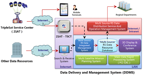
21AT DDMS is a total solution for a customer who needs to receive TripleSat Constellation images, as well as other satellite data, manage the mass data from various data sources in one catalog and make the data available to its subordinates. 21AT DDMS comprises seven subsystems, which can be combined in a very flexible manner based on customer needs. These seven subsystems are: (i) TSCT; (ii) data management system, (iii) data distribution system, (iv) 3D display and conference system, (v) Multi-satellite mission simulation system, (vi) Multi-source data access system, and (vii) mobile terminal system. The solution system diagram is shown in Figure .
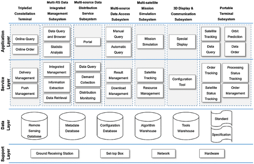
21AT DDMS is established in the Client/Server and Browser/Server mixed system model and developed by the computer programming languages of JAVA, C#, and C++, etc. It forms a time-space integrated multi-source remote sensing product database, which also supports data management and application development. The following sections provide the detailed descriptions of each of the seven subsystems involved in the solution. The Hierarchical structure diagram of solution system is shown in Figure .
4.1. TripleSat constellation terminal
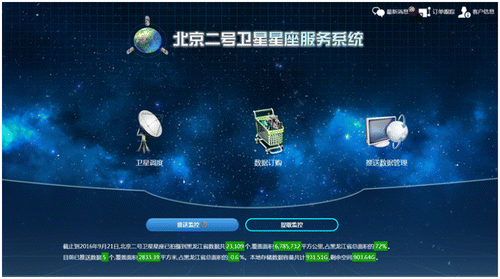
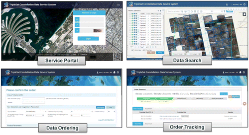
The TSCT allows users to have a real-time interface to the TripleSat constellation database, realizing the enquiry of the data catalog, and purchase of data products online. The production status of the ordered data could be also monitored by the users. The system allows users to automatically download the deliverables, during which the breakpoint resume is also supported. The downloaded data products could be further managed by the data management system and subsequently be put in its storage. The system consists of four modules, including data enquiry, data purchase, data acceptance, and the personal center. (Wang and He Citation2015; Zhang, Tang, and Li Citation2016). A screenshot of the user interface of the TSCT is shown in Figure .
The data enquiry module enables the users to query the database catalog of the TripleSat Constellation, while the search engine supports the choice of satellite, time & location, and the rate of cloud coverage. The detailed catalog information of the database could be checked, and the quick-view images could also be overlaid on the base map, helping users in the data selection.
The data purchase module includes both archiving data and tasking data procurement. The module allows users to have a real-time tracking of the submitted order forms, including the approval status, production, and the delivery status. The function of order form consultation also enables users to communicate directly with the data administrators.
The data reception module realizes a real-time interface to the TripleSat Constellation database. The data downloading is automatic, which consists of the data ordered by the users or pushed by the system. The users are able to select the download path and to connect with the Data Management System, sequentially realizing the closed-loop management from data downloading to storage.
The personal center allows the users to check the data order forms and modify the registration information. The submitted order can be searched in the system in different ways (Song Citation2015).
The other important function of the TSCT is tracking the satellites and shows the real-time satellite passes over the target area; thus, it can generate an accurate data acquisition request in a fast and straightforward manner. The request will be seamlessly submitted from the TSCT to the mission control center of the TripleSat constellation, via the secured network. Subsequently, the received images will be automatically pushed to the customer site.
4.2. Data management subsystem
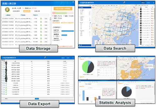
The data management subsystem allows the users to effectively manage multi-source remote sensing data, including the storage, management, searching, browsing, and exporting. These functions are illustrated in Figure .
The data storage function provides support for the bulk data operations of both automatic manner and manual manner. Varieties of remote sensing data and derived information products could be put in storage uniformly, providing a real-time review of the schedule and statistical information (Wang et al. Citation2016).
The data management function enables the users to manage the mass data, meanwhile providing multiple searching manners. Moreover, the map-based display, extraction and exportation of data resource are also supported (Lv, Cheng, and Gong Citation2011).
The data migration function realizes the immigration and emigration of the stored data, contributing to the exchange among different network architectures and equipment.
The statistical analysis function consists of multiple subfunctions, and the user-concerned statistical information could be displayed directly with the visual diagrams and tables (Jiao, Ma, and Deng Citation2015).
4.3. Data distribution subsystem
The data distribution subsystem is established to be service provider-oriented, centralizes the searching and delivery of multi-source remote sensing data, and supports both online and offline services, as depicted in Figure .
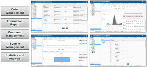
To support information management of data distribution subsystem, a separate operation management system has been developed. This subsystem implements the safe and hierarchical user authorization management, order approval, statistical data analysis, and information publishing, etc. The subsystem is responsible for providing robust safety and technical support to the whole platform operation, as shown in Figure , which shows the various geospatial functions involved in the operational management of the subsystem.
4.4. 3D display and conference subsystem
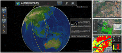
The 3D display and communication subsystem is an integrated 3D remote sensing data visualization system, which displays multi-satellite source imagery, thematic information, geostatistical reports, and typical application cases, etc. With this module, users are able to visit the data management system, subsequently realizing the display of the data information on the 3D platform. Meanwhile, the module provides the custom tools to display the multi-satellite source imagery and thematic information synthetically. In addition, the 3D display and communication subsystem supports the management of long-time series data, providing a convenience for data comparison. (Guo, Chen, and Han Citation2016; He et al. Citation2011) Figure illustrates the capabilities of the subsystem.
4.5. Multi-satellite mission simulation subsystem
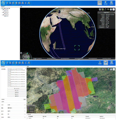
The multi-satellite mission simulation subsystem consists of three primary subfunctions, including the satellite tracking, task simulation, and satellite resource management.
The satellite tracking function provides the real-time monitoring of satellite position and operation status, meanwhile displaying to users the combination of 2D&3D. With this module, the users are able to track the real-time position of the satellites, and to check the status information of satellites. At the same time, the users can make predictions about the orbit positions of the satellites, so as to view, fast forward, and rewind the orbit. Furthermore, the orbit plane could be fixed, in order to view the status of the Earth’s rotation (Guo, Chen, and Han Citation2016).
The satellite task simulation function makes use of orbit tracks, payload operation, and off-pointing parameters of a selected satellite to simulate the imaging mission over a targeted area. Users are able to decide the time needed, the selection of satellite track, and the number of scenes (He et al. Citation2011; Song Citation2015).
Satellite resource management means that users can manage varieties of satellite resources, and set the initial information of orbits and sensors. Moreover, the ground station resources can be managed, including the setting of tracking angles of different satellites (Li, Yang, and Huang Citation2014).
Of course, the subsystem is not limited to the TripleSat Constellation. Many other satellite sources can also be added into the subsystem. A screenshot of the subsystem is depicted in Figure .
4.6. Multi-source data access subsystem
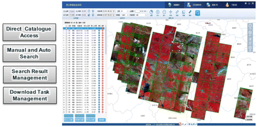
Besides providing TripleSat Constellation images, the multi-source data access system also allows users to access other satellite data sources, based on customized agreement. Users can do manual and automatic search in the archive and download the images as requested. An example of how to access other satellite data source is shown in Figure .
4.7. Mobile terminal subsystem
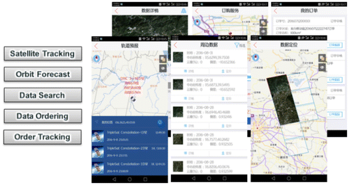
The subsystem has a mobile application module, which supports popular Android and iOS mobile operating systems. With this module, the user is able to use his mobile device to view in real time the satellite status, check the data availability, as well as both submit and track orders. These geospatial aspects of this mobile application module are shown in Figure , which explains several of the key functions of this module.
5. Conclusions
Having described the seven subsystems of the 21AT TSCT and DDMS, it can be clearly seen that worldwide users are now able to access the strong TripleSat Constellation satellite data source in the fastest and simple manner. All users can watch the satellite status in real time, submit tasking requests, and track their orders, even via a mobile device from home. Subject to the customized service agreement and multiple data channels provided by 21AT, all users may access multiple satellites and other remote sensing data sources. This geospatial information solution gives all users maximum flexibility to choose modules that fit their preference in order to solve their geospatial information needs.
Therefore, this new 21AT DDMS solution combined with its core system, TSTC allows its users to obtain maximum benefit from the TripleSat Constellation. The comprehensive solution provided to users has exhibited an efficient approach on how to use and manage remote sensing data to support their geospatial applications and projects.
Funding
This work was supported by the project of Beijing Municipal Science and Technology Commission and Science and Technology Innovation Base of Cultivating and Developing Engineering [grant number Z161100005016069]; and the National High Technology Research and Development Program [grant number 2013AA12A303].
Notes on contributors
Qiang Wen is a vice-general manager and senior project manager with 21AT. He is responsible for remote sensing research, application and service activities. He is mainly engaged in data delivery and management service based on remote sensing and geographic information system.
Jianjun He is a chief technology officer with 21AT. He is responsible for enterprise technology activities; contribute to research and development remote sensing and geospatial service technologies. He holds a master of cartography and geographic information system from Peking University.
Shengyong Guan is a chief project officer with 21AT. He is actively involved in the planning and management improvement activities of data delivery and service projects. He holds a bachelor of software engineering from Tsinghua University.
Ting Chen is a senior research engineer with 21AT. She is actively involved in the research and development of remote sensing applications and programs. She has been working in this current job since graduating from China University of Geosiciences Beijing as a doctor of environmental science and engineering in 2009.
Yin Hu is an international business development manager in 21AT. He is responsible for marketing and promoting the Earth observation satellite imagery product and value added service, especially focusing on the TripleSat constellation-related services. He actively collects front market information and feedback to support the company’s research and development of the geospatial product and services.
Wenbin Wu is a middle technology research engineer in 21AT. He is actively involved in research and development of the geospatial product service system and technology programs. He has been working in this current job since graduating from Capital Normal University as a master of cartography and geographic information system in late 2014.
Feng Liu is a junior technology research engineer in 21AT. He is actively involved in research and development of remote sensing applications and programs. He has been working in this current job since graduating from China University of Geosiciences, Beijing as a master of cartography and geographic information system in late 2015.
Yuexia Qiao is a middle technology research engineer in 21AT. She is actively involved in research and development of remote sensing geospatial applications and programs. She has been working in this current job since graduating from China Agricultural University as a master of cartography and geographic information system in late 2014.
Suet Yheng Kok is a geospatial applications engineer in 21AT (Asia). She is responsible for imagery processing and analysis activities; contribute to research and development employing remote sensing and geospatial technologies. Prior to her current role, She worked for Esri Singapore, offering GIS technical support on government projects. Suet Yheng holds a bachelor of geoinformatics from the University of Technology Malaysia.
Samuel Yeong is a geospatial application engineer with 21AT (Asia). He is actively involved in the research and development of geospatial applications and programs meant to aid the extraction of information from the company’s own catalog. He has been working in this current job since graduating from the National University of Singapore in late 2015.
References
- Denis, G., B. H. Boissezon, and S. Hosford. 2016. “The Evolution of Earth Observation Satellites in Europe and its Impact on the Performance of Emergency Response Services.” Acta Astronautica 127 (10–11): 619–633. doi:10.1016/j.actaastro.2016.06.012.
- Guo, C. B., H. Y. Chen, and X. B. Han. 2016. “Visual Simulation of the Multi-system Interactive Verification for Remote Sensing Observation Satellite.” Computer Simulation 33 (4): 144–149.
- Hastings, D., B. Putbrese, and A. Tour. 2016. “When will On-orbit Servicing be Part of the Space Enterprise?” Acta Astronautica 127 (10–11): 655–666. doi:10.1016/j.actaastro.2016.07.007.
- He, R. J., P. Gao, B. C. Bai, and J. F. Bai. 2011. “Models, Algorithms and Applications to the Mission Planning System of Imaging Satellites.” Systems Engineering Theory & Practice 31 (3): 411–422.
- Ji, X. P. 2013. “Design and Implementation of HY-2 Product Distribution System.” PhD diss., Beijing Jiaotong University.
- Jiao, H. K., L. B. Ma, and R. R. Deng. 2015. “Design and Implementation of Multi-source Remote Sensing Image Data Management and Remote Processing Service System.” Science of Surveying and Mapping 40 (11): 131–136. doi:10.16251/j.cnki.1009-2307.2015.11.027.
- Kang, Y. 2012. “The Study of Ocean Satellite Data Service Based on Web.” PhD diss., ZHEJIANG University.
- Li, Z. L., C. W. Yang, and Q. Huang. 2014. “Building Model as a Service to Support Geosciences.” Computers, Environment and Urban Systems 61 (7): 141–152. doi:10.1016/j.compenvurbsys.2014.06.004.
- Liu, J. B., J. Yang, and F. Chen. 2014. “Location-based Instant Satellite Image Service: Concept and System Design.” International Journal of Digital Earth 8 (2): 89–99. doi:10.1080/17538947.2014.942395.
- Lv, X. F., Q. C. Cheng, and J. Y. Gong. 2011. “Review of Data Storage and Management Technologies for Massive Remote Sensing Data.” Science China Technological Sciences 54 (12): 3220–3232. doi:10.1007/s11431-011-4549-z.
- Mantas, V. M., Z. Liu, and A. J. S. C. Pereira. 2015. “A Web Service and Android Application for the Distribution of Rainfall Estimates and Earth Observation Data.” Computers & Geosciences 77 (4): 66–76. doi:10.1016/j.cageo.2015.01.011.
- Qian, J. M., A. L. Sun, and Z. Xu. 2012. “Fengyun Series Meteorological Satellite Data Archiving and Service System.” Journal of Applied Meteorological Science 23 (3): 369–376.
- Song, N. 2015. “Research and Application for Multi-satellite Cooperative Mission Planning Technology.” PhD diss., University of Chinese Academy of Science.
- Tan, X. C., L. P. Di, and M. X. Deng. 2016. “Agent-as-a-service-based Geospatial Service Aggregation in the Cloud: A Case Study of Flood Response.” Environmental Modeling & Software 84: 210–225. doi:10.1016/j.envsoft.2016.07.001.
- Wang, W., and R. J. He. 2015. “The Data Service Mode of Remote Sensing Satellite Based on the Internet Thinking.” Science Technology and Industry 15 (9): 39–44.
- Wang, C. L., C. R. Li, and B. Jia. 2007. “Development of Satellite Data Catalogue and Archive System.” Journal of Remote Sensing 11 (3): 385–389.
- Wang, Y. T., Z. Xing, S. H. Li, and Y. W. Li. 2016. “Application of Multi-sensor Imagery Modeling in Marine Remote Sensing Imagery Management.” Science of Surveying and Mapping 41 (2): 163–167. doi:10.16251/j.cnki.1009-2307.2016.02.033.
- Xu, W., J. Gong, and M. Wang. 2014. “Development, Application, and Prospects for Chinese Land Observation Satellites.” Geospatial Information Science 17 (2): 102–109. doi:10.1080/10095020.2014.917454.
- Yang, B. H., and T. H. Chi. 2011. “China-made Satellite Remote-sensing Integrated Application Service Platform and its Implementation.” Computer Engineering and Applications 47 (22): 236–239. doi:10.3778/j.issn.1002-8331.2011.22.064.
- Zhang, Z., P. Tang, and H. Y. Li. 2016. “Refined Domain Model for Multi-source Data Synergized Quantitative Remote Sensing Production System.” Journal of Remote Sensing 20 (2): 184–196.
- Zhou, W., W. Huang, and Y. Z. Wang. 2014. “Tentative Construction of Satellite Data Management and Service System for ZY-1 02C.” Remote Sensing for Land and Resources 26 (1): 179–185. doi:10.6046/gtzyyg.2014.01.30.

