
Abstract
This paper reviews the key role that Earth Observations (EO) play in achieving the Sustainable Development Goals (SDGs) as articulated in the 2030 Agenda document and in monitoring, measuring, and reporting on progress towards the associated targets. This paper also highlights how the Group on Earth Observations (GEO) would contribute to ensure the actual use of EO in support of the 2030 Agenda; and how the Global Earth Observations System of Systems meets requirements for efficient investments in science and technology and a good return on investment, which is elaborated in the Addis Ababa Action Agenda on development financing. Through a number of examples, we first discuss how extensive EO use would: provide a substantial contribution to the achievements of the SDGs by enabling informed decision-making and by allowing monitoring of the expected results; improve national statistics for greater accuracy, by ensuring that the data are “spatially-explicit” and directly contribute to calculate the agreed SDG Targets and Indicators support the fostering of synergy between the SDGs and multilateral environmental agreements by addressing cross-cutting themes such as climate and energy; and facilitate countries’ approaches for working across different development sectors, which is, according to the special adviser on the 2030 Agenda, a key challenge to achieve the SDGs. We then focus on the role that GEO could play in enabling actual use of EO in support of the 2030 Agenda by directly addressing the Strategic Development Goal 17 on partnerships.
1. Background
Earth observation (EO) data informs our daily lives and all geophysical and atmospheric sciences. From forecasting weather to monitoring natural disasters and the health of ecosystems, communities and citizens, EO data informs, locates and provides context for research and policy-making including achieving sustainable societies.
EO data informs a wide variety of applications including tracking biodiversity and wildlife trends; measuring land use change such as deforestation; mitigating, and managing the impact of natural disasters, including fires, floods, earthquakes, and tsunamis; sustainably managing natural resources, such as energy, freshwater, and agriculture, address emerging diseases and other health risks; and predicting, adapting to, and mitigating climate change (eg Figure ).
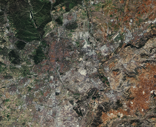
Figure 1. Madrid, Spain. EO is useful to show land change over time (Copyright: Copernicus sentinel data, 2015, European Space Agency (ESA)).
The Group on Earth Observations (GEO) was described in the 2002 World Summit on Sustainable Development Implementation Plan, launched in 2005, and has been supported by a succession of G20 and G7/8 meetings, responding to the need for coordinated observations relating to the state of the Earth.
In September 2015, the United Nations (UN) General Assembly endorsed “Transforming Our World: the 2030 Agenda for Sustainable Development”, a global development agenda for all countries and stakeholders to use as a blueprint for progress on economic, social, and environmental sustainability. Seventeen Sustainable Development Goals (SDGs) and associated Targets and Indicators anchor the 2030 Agenda, which specifically calls for new data acquisition and exploitation of a wide range of data sources to support implementation. In fact, Article 76 states, “We will promote transparent and accountable scaling-up of appropriate public-private cooperation to exploit the contribution to be made by a wide range of data, including EO and geo-spatial information, while ensuring national ownership in supporting and tracking progress”.
The G7 Environment Ministers 2016 Communiqué on Climate Change and Related Measures on Mitigation measures including market-based approaches article 40 made reference to the Importance of EO, “We recognize the necessity of robust EO to enhance our ability to measure and monitor Greenhouse Gas (GHG) emissions”. Further, the G7 Science and Technology Ministers 2016 Communiqué, Article 6, Open Science – Entering into a New Era for Science noted: “Fundamental to the progress of open science is the continued investment by governments and others, such as the Global EO System of Systems (GEOSS) of GEO, in suitable infrastructures and services for data collection, analysis, preservation and dissemination”.
GEO is a coalition of 104 governments and 106 participating organizations with a mission to implement a GEOSS to meet the need for timely, quality, long-term, and global information as a basis for sound decision-making.
GEO and the GEOSS contains EO from diverse sources, including satellite, airborne, in situ platforms and citizen observatories, which, when integrated together, provide powerful tools and insights for understanding the past and present conditions of Earth systems, as well as the interplay among them. Taken together with geospatial information and technologies, EO offer a unique global platform for pursuing societal benefits towards a more sustainable, safer, and viable future. At a national level, EO are carried out by a variety of actors, such as the US National Oceanic and Atmospheric Administration (NOAA), the US National Aeronautics and Space Administration (NASA), the US Geological Survey (USGS), the ESA, the UK Meteorological Office, Geoscience Australia and others.
The GEO community is building GEOSS, a set of coordinated, independent-EO, information and processing systems that interact and provide access to diverse information for a broad range of users in both public and private sectors. Around 150 data providers contribute to GEOSS including the Conservation of Arctic Flora and Fauna (CAFF, for data on biodiversity in the Arctic), the Committee on EO Satellites (CEOS), China, ESA, Esri − a private sector company specializing in Geographic Information System (GIS) mapping, the Japan Aerospace Exploration Agency (JAXA), NASA, the UN Economic Commission for Africa (UNECA)’s Regional Centre for Mapping of Resources for Development (RCMRD, based in Kenya), and many others. In total, there are around 200 million data sets available. The use of GEOSS data and information has grown exponentially, receiving more than 4 million inquiries in 2016 alone. The statistics are live at GEO DAB STATISTICS (GEO DAB Citation2017).
GEO curates the GEOSS Portal and the GEOSS Discovery and Access Broker component, allowing the end-user to discover, access and retrieve EO. The combined portal and data access broker are referred to as the GEOSS Common Infrastructure (GCI).
GEO convenes members of it global community to engage on the 2030 Agenda, by working with the UN Statistics Division (UNSD), the UN Inter-Agency Expert Group on the SDG (IAEG-SDG) and the UN SDG Custodian Agencies for the SDG Targets and Indicators. GEO also engages with a variety of global and regional partnerships using innovative techniques to caption and use new data including “Big Data”, and creating dynamic, cost-effective, and non-traditional sources of data (eg EO, geospatial information, mobile phone and social media data) that can help address societal challenges. GEO is also engaging with the private sector to enable the use of EO to ensure that “no one is left behind”, the basic principle of the 2030 Agenda.
The UN Statistical Commission has the mandate for the development and implementation of the Global Indicator Framework. The UN Statistical Commission oversees the UNSD, the central mechanism within the UN to supply global statistics. It brings together chief statisticians from member states from around the world.
Under the worlds’ first universal development agenda, governments play a key role in developing and implementing an effective monitoring framework for the SDGs, via a country-led process that requires wide stakeholder engagement, is linked to governance and reporting processes, and is incorporated into the overall national development frameworks. Each country is guided by the UN SDG Framework, taking into account national development priorities and information from existing reporting mechanisms. Countries can translate SDG Targets to fit national strategies and may communicate needs for support, for example in distinguishing data by gender or rural/urban population disaggregation.
Anticipating General Assembly action, in March 2015, the IAEG-SDG, to develop an indicator framework for the goals and targets of the post-2015 development agenda at the global level, and to support its implementation. The IAEG-SDG is composed of 28 representatives from national statistical offices. Observers to this group include representatives from national statistical offices that are not members of the group, as well as representatives from regional and international agencies. The IAEG-SDG proposed the Global Indicator Framework for the SDG Goals and Targets, which was submitted to the 47th session of the UN Statistical Commission in March 2016 (UNSD Citation2016) for approval. Further, the IAEG-SDG will establish the baseline data required for tracking the Indicators, as well as the periodicity of reporting.
In August 2016, IAEG Members held several rounds of internal consultations seeking to identify not only Indicators that needed refinement, but also Targets where additional Indicators may be necessary. The members identified 33 Targets where possible additional Indicators could be considered; a total of 36 Indicators were reviewed for UN Secretariat on Global Geospatial Information Management (UNGGIM) (UNGGIM and GEO Citation2015).
2. EO to measure and monitor the SDGs: enabling informed decision-making using the value of open data
The GEOSS Portal is one of the world’s few global systems for accessing EO data, as well as government, organizational and private sector data for remote sensing, in situ and atmospheric data. GEO is therefore in a unique position to support the 2030 Global Goals for Sustainable Development, as affirmed by governments in the GEO Mexico City Declaration:
Affirm that GEO and its EO and information will support the implementation of, inter alia, the 2030 Global Goals for Sustainable Development, the Sendai Framework for Disaster Risk Reduction 2015–2030, the UN System of Environmental and Economic Accounts, and the UN Framework Convention on Climate Change (UNFCCC).
GEO supports the implementation of the 2030 Agenda with a dedicated Initiative, EO for Sustainable Development (EO4SDG) in Service of the 2030 Agenda. The primary purpose of EO4SDG is to organize and help realize the potential of EO to advance the 2030 Agenda and enable societal benefits through achievement of the SDG. The goals of the Initiative include demonstrating how EO, geospatial information, and socioeconomic and other data contribute in novel and practical ways to support achievement of the SDG; to increase skills and capabilities in uses of EO4SDG activities and their broader benefits; and to broaden interest and awareness of EO support to the SDG, and contributions to social, economic, and environmental benefits. The Initiative aims to achieve these goals via four implementation mechanisms: a portfolio of national pilot projects in one or more GEO Member countries focused on integrating EO with national statistical accounts to better measure, monitor and achieve the SDG; capacity building activities that aim to provide support to institutions and individuals in the formation, development, and implementation of EO methods and data to achieve the SDG; identify data and information products to advance the provision, access, discoverability, and applicability of EO for use with the SDG; and a portfolio of outreach and engagement activities to promote the consideration and adoption of EO4SDG by nations and stakeholders.
2.1. Creating a framework: EO for the 2030 Agenda and Big Data
The UNGGIM is leading the IAEG-SDG Working Group on Geospatial Information (WGGI) efforts to integrate GIS data and EO data – for the purposes of this article collectively known as EO data − into statistical data that are essential for the production of a number of Indicators. Furthermore, the WGGI has agreed to provide in-depth analysis, recommendations, and advice on the development of methodologies for a subset of Indicators, and undertake methodological work in a variety of cross-cutting themes including data disaggregation, national and sub-national reporting, and other data (eg citizen science, crowdsourcing data, and volunteered geographic data). GEO is an invited member of the UN IAEG-SDG/WGGI to contribute knowledge and expertise on EO and geospatial information to the discussion of SDG indicators. The GEO EO4SDG Initiative supports the WGGI’s in-depth analysis and development of methodologies for a subset of SDG Indicators, on water-related ecosystem change, land degradation, and population within 2 km from basic services.
In parallel, the UN Global Working Group on Big Data for Official Statistics is exploring the potential of EO for estimating official statistics and indicators. It was mandated by the Economic and Social Council in 2014, and has been reporting to the UN Statistical Commission on the outcomes of an ongoing series of annual international conferences on Big Data for Official Statistics, held in 2014, 2015 and 2016. Of the seven Task Teams, one is dedicated to Satellite Imagery and Geo-Spatial Data. This Task Team on Satellite Imagery and Geo-Spatial Data is investigating the use of remote sensing imagery:
Satellite imagery has significant potential to provide more timely statistical outputs, to reduce the frequency of surveys, to reduce respondent burden and other costs and to provide data at a more disaggregated level for informed decision making. (Big Data UN Global Working Group Citation2016)
Another of the seven Task Teams on Big Data and the SDGs is investigating how the digital information continuously generated by GPS devices, mobile phones, satellites and social media, commonly termed as Big Data, requires new tools and methods for capturing, managing and processing them efficiently. This Big Data Project Inventory also has points in common with methods explored by the Task Team on Satellite Imagery, but for the purposes of this article we will focus primarily on the latter.
The remaining Task Teams focus on Access and Partnerships; Mobile Phone Data; Social Media Data; Training, Skills and Capacity-building; and a Committee on Global Platform for Data, Services and Applications which will build on best practices of public and private Big Data initiatives.
2.2. An efficient investment
The global community recognizes that the data and reporting processes to support the SDG will be resource intensive. UN estimates for statistical systems alone to reach $300–500 million per year.
Prior to the SDG Target and Indicator process, the international community assessed how to finance development, in the post Millennium Development Goals (MDG) era, in the post 2008 financial crisis era, when funding challenging and for a 2030 Agenda that operates on a universal scale that includes both developed and developing nations. The Addis Ababa Action Agenda (AAAA) of the Third International Conference on Financing for Development was issued in July, 2015, and lists a number of points pertinent as to why EO are important to monitor and achieve the SDG and represent a good value for investment by countries, international development assistance providers and regional development banks.
Governments are committed to investing in technology and making data more accessible, as outlined in the AAAA for financing the SDG Section II. G. − “Science, technology, innovation and capacity building” (AAAA Citation2015); and Section III. − “Data, monitoring and follow-up” (AAAA Citation2015).
In addition to investments in EO technology, for instance the hardware of satellites or the Argo Ocean monitoring floats, the resulting data must also be accessible. This is true to the spirit of “leave no-one behind”, the basic principle of the 2030 Agenda. An open data policy is essential for mutual accountability. Access to EO data that permits information to be obtained, used and combined in a scalable, objective, and repeatable manner improves transparency and allows for more fair and equitable decision-making.
Access to reliable data and statistics helps Governments to make informed decisions, and enables all stakeholders to track progress and understand trade-offs, and creates mutual accountability. (AAAA Citation2015)
However, challenges exist in cases where governments or scientists are unwilling to share their data.
Prior to the US’s Landsat data being made freely available in 2008, an average of 53 Landsat scenes per day were being downloaded, at a cost of approximately $500 per scene. After the open data policy, an average of 5,700 scenes a day were, and still are being downloaded; by 2016 more than 40 million Landsat scenes were downloaded.
Not only did the uptake of EO images for scientific purposes increase, it also generated revenue. In 2015, the Landsat Advisory Group of the National Geospatial Advisory Committee, a team of commercial (Google, Esri), Federal, State and Local Government entities, and Non-Governmental Organization (NGO) geospatial information experts, including experts from Stanford University, undertook a critical review of the value of the Landsat information.
The study looked at applications of Landsat data such as Government Mapping, Monitoring Consumptive Agricultural Water Use, Forest Change Detection, Flood Mitigation, Coastal Change and Wildfire Risk Assessment. It found that 16 Landsat applications alone produced savings of $350 million to over $436 million per year for Federal and State Governments, NGOs, and the private sector (National Geospatial Advisory Committee Citation2014). The study also notes, that these savings, and others not addressed by the paper will continue to accelerate. The Advisory Committee found that “the economic value of just one year of Landsat data far exceeds the multi-year total cost of building, launching and managing Landsat satellites and sensors”.
Following Landsat’s lead on open data, other data providers have agreed to provide data free of charge, including the European Commission’s Copernicus program, Geoscience Australia, Mexico, among others.
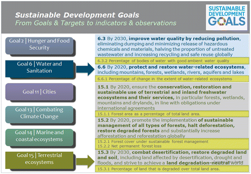
EO provide a substantial contribution to the achievements of the SDG by enabling informed decision-making and monitoring the expected results (Figure ). Furthermore, observations and EO-based methods are portable and non-intrusive, and can easily be scaled to sub-national as well as regional and global levels.
Figure 2. Examples of SDG goals, targets, and indicators which can be informed by EO.
The qualities of satellite data for monitoring the SDG have been summarized by the IAEG-SDG WGGI Task Team and are summarized as:
| • | Consistent, global monitoring over the 15-year time span of the SDGs, for any country in the world, regardless of that country’s GDP; | ||||
| • | Reliable, recording and reporting of data, results can be trusted. | ||||
| • | Transboundary, data from national to basin scale; | ||||
| • | Transparent, methodologies with weaknesses and strengths identified. | ||||
| • | Verifiable, the information can be traced to its origin; | ||||
| • | Feasible, the data can be recorded in a practical and realistic way; | ||||
| • | Pragmatic, the collected data and methodology used for the indicators can be used for strategy planning, awareness raising, risk assessment and the development of policies; | ||||
| • | History, long-term trend analysis eg Climate change; | ||||
| • | Sustainable, open and free operational data. | ||||
3. EO to measure and achieve sustainable development
The SDGs address the three inter-connected elements of sustainable development: economic growth, social inclusion, and environmental sustainability. One of the challenges to achieving the 2030 Agenda, according to the UN Secretary General’s Special Adviser on the 2030 Agenda, is how to work across and between sectors, for example health and environment (Nabarro Citation2016).
Combining data layers of geospatial and EO can contribute new information that helps work across and among sectors and data providers, while fostering synergies. EO data can also facilitate countries’ approaches to working on key development policy challenges measured by the SDGs.
Goals, Targets, and Indicators are meant to assist countries to measure, manage and monitor progress on economic, social and environmental sustainability. The value of EO is to improve national statistics for greater accuracy, by ensuring that the data are “spatially-explicit” and directly contribute to informing and supporting the agreed SDG Targets and Indicators. EO data and information can contribute as a direct indicator in themselves, help augment statistical data and validate national statistics, while also providing disaggregation and granularity of the Indicators, as needed.
During its 3rd meeting, the IAEG-SDG established a system of UN custodian agencies to support country processes for the SDG Indicators reporting and monitoring. These agencies are responsible for collecting data from national sources, validating and harmonizing them, estimating regional and global aggregates, and making this information available for international reporting. Additionally, they are responsible for producing metadata documentation on the methodology and data standards for each Indicator, reflecting the latest information produced by the UN system and other international organizations, and contributing to the annual SDG progress reports and the High-Level Political Forum’s review processes. However, a distinct challenge that exists is that agencies often work in “silos” rather than collaborating across organizations and disciplines to develop common outcomes.
3.1. Data available and clear methodology: protected areas – Goals 14 and 15
Reliable satellite-based monitoring of forest cover requires EO systems that have global, systematic acquisitions; free and accessible data; and high quality imagery, such as that offered by the Landsat program and ESA’s Sentinel missions. EO can act as a source to help countries monitor, track, and report on two goals with an obvious link to the environment: Goal 14, Life below water and Goal 15, Life on land. Specifically, EO can help inform the Targets and Indicators relating to protected areas: 14.5, By 2020, conserve at least 10% of coastal and marine areas, consistent with national and international law and based on the best available scientific information, and 14.5.1, Coverage of protected areas in relation to marine areas. The Indicator coverage of protected areas in relation to marine areas shows temporal trends in the percentage of important sites for marine biodiversity (ie those that contribute significantly to the global persistence of biodiversity) that are wholly covered by designated protected areas.
Key Biodiversity Area (KBA) identification has been validated for a number of countries and regions where comprehensive biodiversity data allow formal calculation of the site importance (or “irreplaceability”) using systematic conservation planning techniques. Future developments of the indicator will include: (a) expansion of the taxonomic coverage of marine KBAs through application of the Key Biodiversity Areas standard (IUCN Citation2016) to a wide variety of marine vertebrates, invertebrates, plants and ecosystem type; (b) improvements in the data on protected areas by continuing to increase the proportion of sites with documented dates of designation and with digitized boundary polygons (rather than coordinates); and (c) exploring other methods for assessing and presenting temporal trends in protected area coverage.
EO have a clear role in assessing the environment that is so crucial to biodiversity and life itself. A number of methods are available to do so. The living base layer of the ocean is Phytoplankton, microscopic plants that support nearly all marine life and supply half of breathable oxygen. The timing of this small marine organism’s growth is critical for the survival of fish and crustaceans. ESA, has invested in the first-ever study of phytoplankton phenology, the timing of plankton growth in the Red Sea, one of the warmest and saltiest bodies in the world.
ESA’s Ocean Color Climate Change Initiative uses satellite data to determine the level of phytoplankton during both winter and summer, and whether the phytoplankton is harmful or helpful to fish and other animals. Research such as this can provide vital inputs to inform decisions related to recreation, tourism, and conservation in such countries as Egypt and Saudi Arabia (Figure ).
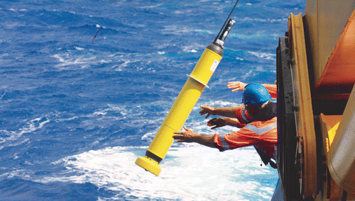
Figure 3. Argo floats are used to observe the ocean (Credit: Commonwealth Scientific and Industrial Research Organization (CSIRO)).
Furthermore, satellite imagery from space has to be verified through in situ sampling and application of data to population models. Direct observations show presence, abundance, phenology and genomic information which gives meaning to remote sensing data.
Traditional biodiversity sampling methods include nets, visual observations from marine vessels or by divers, hooks and lines, traps, dredges, submersibles and remotely operated vehicles. In many countries, bottom trawl surveys are used for monitoring commercially important fish stocks, analyzing trends in the abundance, distribution and diversity. However, bottom trawling often damages the marine environment and in order to measure microbes such as bacteria, a different methodology is required. Quantitative sampling is best focused on measuring dynamics of particular species populations rather than measuring biodiversity across species, according to a new report on methods for the study of marine biodiversity, The GEO Handbook on Biodiversity Observation Networks (BONs).
In a groundbreaking study, vertebrate biodiversity in Monterey, California, was tracked by metabarcoding environmental DNA (eDNA). The dominance of Sardinops sagax (pacific sardine) or Engraulis mordax (northern anchovy) were already known to be strong drivers of trophic interactions – or relative positions in the food chain. As part of the global marine biodiversity observational network initiative, researchers used seawater samples collected in late summer to mid-autumn over a span of eight years, from 2008 to 2015, to examine the change in marine vertebrate eDNA. The DNA study reveals more than 20 fish genera in the area with Engraulis (anchovy) recorded as the more abundant species from 2013 to 2015, consistent with visual observations. A time series data product showing species richness and diversity over time is also under development.
The “twin” goal to Global 14 is Goal 15: Sustainably manage forests, combat desertification, halt and reverse land degradation. Of interest, in terms of protected areas is Target 15.4 By 2030, ensure the conservation of mountain ecosystems, including their biodiversity, in order to enhance their capacity to provide benefits that are essential for sustainable development and Indicator 15.4.1 Coverage by protected areas of important sites for mountain biodiversity. This Indicator and the protected area indicator for oceans are under the custodianship of the UN Environment Programme (UNEP) World Conservation Monitoring Centre (WCMC). Data sets for protected areas were required for MDG reporting and are generally available for most countries.
Forests can be defined using structural attributes of tree cover and height. Forest cover extent, loss and gain are categorical labels derived from these, threshold-based structural attributes. Another forest-related indicator is also monitored through EO, especially in cases where a strong forest inventory is absent; Target 15.1: By 2020, ensure the conservation, restoration and sustainable use of terrestrial and inland freshwater ecosystems and their services, in particular forests, wetlands, mountains and drylands, in line with obligations under international agreements; Indicator 15.1.1 Forest area as a percentage of total land area, under the custodianship of the UN Food and Agriculture Organization (FAO) and supported by UNEP. The international agreements referred to specifically include the Convention on Biodiversity Aichi Targets.
FAO has been collecting and analyzing data on forest area since 1946. This is done at intervals of 5–10 years as part of the Global Forest Resources Assessment (FRA). FRA 2015 contains information for 234 countries and territories on more than 100 variables related to the extent of forests, their conditions, uses and values for various points in time: 1990, 2000, 2005, 2010 and 2015.
Progress towards more regular assessment of sustainable forest management has been made in recent years. Landsat-derived image composites and metrics are generated globally as part of the global forest watch initiative of World Resources Institute and by independent laboratories, such as the University of Maryland Global Land Cover Facility. National-scale data are a subset from the global data, and are delivered to the respective national counterparts responsible for the mapping and monitoring of forest resources. To report on 15.2.1, forest cover extent, loss, and gain are the primary inputs for assessing intact, primary/long-lived forests, as well as afforestation or reforestation. All intact and primary forest lands are monitored and a reference state (eg forest type, carbon stock), change factor (eg logging, fire), and official land use (eg forestry, protected area) data are integrated with forest change data.
NASA, USGS, and the University of Maryland, College Park have developed an EO-based methodology to help inform Indicators 15.1.1 and 15.2.1, and are currently in the process of engaging with candidate countries for testing the method for SDG reporting. Part of this methodology has already been implemented for a number of countries, including Bangladesh, Colombia, Peru, Republic of Congo, and Vietnam with current activities focused in Cameroon, Guatemala and Nepal. Peru has adopted the method and results for official reporting (eg Reducing Emissions from Deforestation and Forest Degradation reporting platform).
3.2. EO for the big picture
EO imagery can also complement household survey data. A unique quality of EO imagery is that it renders data visible, so that not only the issue, but possible options for solutions can be visualized. The most obvious case of this data visualization among the SDG is Goal 7, Affordable and Clean Energy. Target 7.1 By 2030 ensure universal access to affordable, reliable and modern energy service, and related Indicator 7.1.1 Percentage of population with electricity access, can be visualized using night time satellite imagery to assess the location and spread of electric lighting.
The custodian agency of Indicator 7.1.1 is the World Bank and the IAEG notes that disaggregation of access to electricity by rural or urban place-of-residence is possible for all countries. While the existing global household survey evidence provides a good starting point for tracking household energy access, it also presents a number of limitations, some of which, such as accuracy, standardized and digital data, can be addressed through increased accuracy of EO.
Overall, simple yes/no answers of the presence of electricity through a night light, however, is not sufficient to achieve the Indicator in its entirety because the presence of electricity in the household does not necessarily guarantee that the energy supply is adequate in quality, reliability or affordability. EO can none-the-less be an important complement to household socioeconomic data.
Imagery products from eg the Visible Infrared Imaging Radiometer Suite’s nighttime sensor are generally available within three hours of an overflight of the joint NASA/NOAA Suomi National Polar-orbiting Partnership satellite. Such imagery has a wide range of applications for a broad spectrum of data users. Along with supporting short-term weather predictions and disaster response communities, numerous socioeconomic uses in regard to changes in population density or power outages (eg by spotting absence of lights in known urban areas) are possible.
Substantial progress has already been made toward developing and piloting a new methodology known as the Multi-Tier Framework for Measuring Energy Access, through the custodian agency, the World Bank, (as well as the International Energy Agency, FAO and the Global Alliance for Clean Cookstoves) which is able to capture these broader dimensions of service quality.
3.3. EO to complement the interconnected nature of the SDGs − data available and clear methodology: air quality, Goal 3 and Goal 11
Around 7 million people’s deaths in 2014–2015 are attributable to air quality (WHO Citation2016). Almost one child in seven is breathing heavily polluted air, according to a 2016 United Nations International Children’s Emergency Fund (UNICEF) report, and more than 2 billion children live in areas where pollution exceeds minimum air quality guidelines set by the WHO (UNICEF Citation2016).
The SDGs address this major global health crisis in the first instance under Goal 3: Ensure healthy lives and promote well-being for all at all ages, Target 3.9: By 2030, substantially reduce the number of deaths and illnesses from hazardous chemicals and air, water and soil pollution and contamination, and Indicator 3.9.1: Mortality rate attributed to household and ambient air pollution.
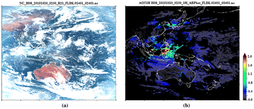
The same issue, albeit in a slightly reworded indicator is covered in Goal 11: Make cities inclusive, safe, resilient and sustainable; Target 11.6 By 2030, reduce the adverse per capita environmental impact of cities, including by paying special attention to air quality and municipal and other waste management. Indicator 11.6.2 Annual mean levels of fine particulate matter (eg PM2.5 and PM10) in cities (population weighted). The observation examples by satellites are given in Figure .
Figure 4. (a) Himawari-8 geostationary satellite delivers aerosol data every 10 min with 5 km resolution. (b) Hot spot detection and forest fire monitoring are conducted using other low Earth orbiting satellites, together contributing to estimates of particulate matter (Credit: JAXA and Earth Observation Research Center (EORC)).
The WHO is assessing calculations for ambient and household air pollution, where annual mean estimates of particulate matter of a diameter of less than 2.5 μm (PM2.5) are modeled as described in (WHO Citation2016), or for Indicator 11.6.2.
Sensors deployed on satellites are able to monitor atmospheric pollution and air quality from space. Data on particulate matter concentrations can be used by statistical agencies, public health organizations, and environmental protection agencies. Ground-based sensor networks combined with space-based observations can efficiently generate nearly complete national data in near real time.
Air quality is measured by atmospheric sensors and NASA’s Globe Program uses satellite imagery to measure outdoor air pollution caused by factors such as vehicle emissions, heavy use of fossil fuels, dust and burning of waste. The EC’s Joint Research Centre (JRC) has an open platform AirSensEUR as well as a citizen science FP7 project CitiSense, focused on emerging technology to develop low-cost sensor needs to be matched by standards. The EU is also developing standards on low cost sensors and the way that data can be shared in the next few years.
WHO reports on attributable mortality, calculated by first combining information on the increased (or relative) risk of a disease resulting from exposure, with information on how widespread the exposure is in the population (eg the annual mean concentration of particulate matter to which the population is exposed, proportion of population relying primarily on polluting fuels for cooking, etc.).
3.4. Data available and clear methodology – the case for EO
In all of the examples above, EO either form significant data sets such as those for protected areas used by UNEP and FAO, or can complement existing datasets such as those predominantly informed by household survey data.
EO can also be tailored for specific indicators – and can be applied, as with the case of Air Quality, to respond to multiple indicators on the same theme, reflecting the interconnected nature of environment and development – as well as among the cross-cutting themes of the Targets.
All of the above examples, where datasets are available and complete, and replicable methodologies exist, are referred to as “Tier I Indicators”. There are cases where it may be challenging to introduce improved data sets from the rapidly expanding possibilities achieved by technological growth and advancements in Big Data accrual and processing. It is worth noting, however, that EO and geospatial information are instrumental in the implementation of integrated solutions, and help support the linkages among national, regional and global level monitoring and reporting.
4. Matching data to Indicators – Tier II and Tier III indicators, an opportunity for improved EO tools
The Global Indicator Framework was intended to be simple yet robust and address all SDG Goals and Targets with the possibility of refinement, as knowledge and data availability improve. An Indicator tier system has been proposed by the IAEG-SDG, based on the level of methodological development and overall data availability (Table ).
Table 1. SDG indicator tier definitions.
A classification exercise resulted in agreement on:
| • | 83 Tier I Indicators; | ||||
| • | 58 Tier II Indicators; | ||||
| • | 84 Tier III Indicators; and | ||||
| • | 5 Indicators that have multiple tiers. | ||||
Work plans have been developed with specialized agencies and experts to discuss available data sources and methodologies for improved coverage of Tier II Indicators and establishment of adequate methodologies and data sources and coverage for Tier III Indicators. The EO community is no exception.
Further developments and future modifications of the Indicators resulting from improved data availability, new methodologies or interlinkages identified across Targets, of a technical nature and not changing the substance of the Indicators, will be reviewed and approved by the Statistical Commission.
4.1. Cross-cutting SDG Indicators informed by EO
The 2030 Agenda interlinks Targets, both within and across Goals. This signals the recognition of a need for a more holistic approach. Using a synergistic approach, mindful of the existing SDG trade-offs and reinforcements seeks to avoid the un-intended consequences that focusing on a single goal can often have on the others. This approach is strengthened by the inclusion of implementation Targets for each Goal, and when applied across-Goals, marks a shift from silo-minded programming towards integrated policy development (Adams and Judd Citation2016).
A UN Department of Economic and Social Affairs (DESA) Working Group paper, Towards Integration at Last? (Blanc Citation2015) presents the SDG as a “network of targets” which links Goals into a system, requiring trade-offs and interdependencies, and is intended to facilitate policy integration across sectors.
Whereas the MDGs were aimed to lift people out of poverty, the SDGs aim to keep them out of poverty, recognizing that development must be socially and environmentally sustainable, and that resources that support development – water, land, forests, etc., – are finite and are needed to support vital ecosystem services. Central to this philosophy is the water–energy–food nexus, which cuts across the SDGs, and can lead to critical trade-offs and conflicts via SDG Target interaction, as is the case when food and energy production compete for the same water resources, or when the expansion of one Goal impedes another. Ending hunger, in turn, depends on access to energy services and water, as energy and water are needed to produce food, while the Targets on sustainable improvement of yields, addressing land conversion for agriculture and sustainable food and agricultural systems, set conditions for how hunger is to be eradicated (Weitz, Nilsson, and Davis Citation2014).
4.2. Agriculture
An initiative of GEO directly supports SDG Goal 2, End hunger, achieve food security and improved nutrition and promote sustainable agriculture, Target 2.c adopt measures to ensure the proper functioning of food commodity markets and their derivatives, and facilitate timely access to market information, including on food reserves, in order to help limit extreme food price volatility.
GEO’s Global Agricultural Monitoring Initiative (GEOGLAM) forms part of the G20 Action Plan on Food Price Volatility. The goal of GEOGLAM is to strengthen the international community’s capacity to produce and disseminate relevant, timely and accurate forecasts of agricultural production at national, regional and global scales through the use of satellite and ground-based EO. The initiative builds on existing agricultural monitoring programs and initiatives at national, regional, and global levels, such as European Commission JRC − Monitoring Agricultural Resources, FAO − Global Information and Early Warning System, Japan-lead Asia Rice, US − National Agricultural Statistics Service, Foreign Agricultural Service, Famine Early Warning Systems Network, and World Food Programme − Vulnerability Analysis and Mapping. GEOGLAM is designed to harmonize reporting among these programs to arrive at global consensus reporting.
The GEOGLAM Crop Monitor for AMIS bulletins provide monthly crop condition assessments for wheat, maize, rice and soybeans, the four primary crop types; for 49 countries (G20 Members plus Spain and seven additional countries), representing 80–90% of global production, consumption and trade of the four commodities. Informed by EO-derived indices, meteorological information and field data used to monitor crop growth conditions, maps, graphs and texts depict crop stage, crop conditions by region, and climatic drivers affecting these conditions.
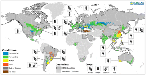
GEOGLAM also produces the Crop Monitor for Early Warning, addressing crop growth monitoring in more than 80 countries at risk of food insecurity. Many of the Countries at Risk are monitored by more than one organization, each with its own combination of available data, tools, information and professional contacts. Collaboration among the organizations reduces uncertainty and improves confidence in decisions to commit resources to support resilience and development programs and to mitigate food security crises (Figure ).
Figure 5. GEOGLAM crop monitor for early warning synthesis, July 2016. Conditions below favorable indicated with a crop icon.
GEOGLAM’s tools were endorsed by the AAAA (Citation2015):
To reach food security, we commit to further investment, including through enhanced international cooperation, in EO, rural infrastructure, agricultural research and extension services, and technology development by enhancing agricultural productive capacity in developing countries, in particular in least developed countries …
GEOGLAM Crop monitors directly respond to the SDG Indicator and are a prime example of tools for enhanced decision-making derived from EO data. As such they can help mitigate market volatility and guide re-insurance markets (AAAA Citation2015). Target 2.c is listed as a Tier III Indicator, under the custodianship of FAO, thereby creating a real opportunity to link GEOGLAM’s products to the SDG Indicator.
4.3. Water
There is no life without water. The challenge for the international community is to agree on how to measure the presence and transitions of water; monitor its social, economic and political importance and assess factors such as drinking water quality and equity of access. Most major components of the hydrological cycle can be estimated with EO including precipitation, evapotranspiration, soil moisture, vegetation, surface water, water quality, water level, snow cover and water storage dynamics. Science shows the links between water supply and sanitation management for improved health, well-being and economic productivity. To ensure sustainable management of water and sanitation for all, it is essential to look at the water cycle in its entirety, including all uses and users creating a more integrated approach that can balance different needs in a just and holistic manner.
However, in a report by The International Council for Science (ICSU) and International Social Science Council (ISSC) experts note for SDG Goal 6: Ensure availability and sustainable management of water and sanitation for all:
This goal should be viewed as an ambitious aspiration that will be very challenging to achieve given that it may require major changes in water management among many nations to harmonize governance, data collection and sharing policies, and the use of models and tools. (ICSU and ISSC Citation2015)
It is stated that research and technology will be needed to better understand and manage the impacts of local decisions on the basin scale. At the same time, there is a need to downscale global model projections to the local level for improved planning. Remote sensing and in situ observations, along with models, are needed to support the ongoing goal monitoring.
Goal 6 is linked directly and indirectly with Targets in each of the other SDGs in particular: Goal 2, water is essential to increase agricultural productivity and industrial food processing; Goal 3, clean water is essential to human health; Goal 5, relieving the burden of women in many countries who spend excessive time accessing safe water for their families; Goal 7, water is essential for most forms of energy production; Goal 12, consumption drives the industrial demand for water. Cleaner production practices reduce water use and pollution emissions; Goal 14, develop management strategies to reduce fluvial erosion and pollution; Goal 15, water in proper quantity and quality is needed to maintain ecosystems and ecosystems services.
Partnerships for Goal 6 on water include UNEP, Ramsar, FAO, UN-Water, United Nations Development Programme (UNDP) CapNet, the Global Environment Facility/Development Banks, GEO-Water, GEO-Wetlands. These organizations and activities are tasked to work together to consolidate information around Goal 6 and although UN Water’s mandate is cross-organizational coordination on water, at national levels, water may be in a variety of ministries, for instance the Ministry of Environment, Interior, Health or other.
4.4. Goal 6: ensure availability and sustainable management of water and sanitation for all
It is estimated that groundwater accounts for around 30% of the world’s total freshwater resources, including those locked in snow and ice, and is by far the largest available reservoir of liquid freshwater. Groundwater serves as the source of about one third of global water withdrawals.
Access to water is described in Target 6.3 By 2030, improve water quality by reducing pollution, eliminating dumping and minimizing release of hazardous chemicals and materials, halving the proportion of untreated wastewater and increasing recycling and safe reuse globally. 6.3.2 Percentage of bodies of water with good ambient water quality is a Tier II Indicator under the custodianship of UNEP with support from UN-Water.
Estimates of the number of people who depend on groundwater supplies for drinking range from 1.5 to 3 billion. Global groundwater abstraction has at least tripled over the past 50 years, much more so in some regions (NOAA Citation2017). However, groundwater does not currently have an agreed upon methodology under the list of Essential Climate Variables (ECV). Water use and River Discharge are also not listed as having significant contributions from satellite EO, Water-related ECVs that are listed by Global Climate Observing System (GCOS) are Ice sheets, Lakes, and Land cover.
4.5. Cross-cutting SDG Indicators informed by EO-DRR
Disaster Risk Reduction Indicators appear three times – in identical language across multiple goals. The Indicator: Number of deaths, missing persons and persons affected by disaster per 100,000 people appears with exactly the same wording as Indicator 1.5.1 under Goal 1, on poverty, Target 1.5 By 2030, build the resilience of the poor and those in vulnerable situations and reduce their exposure and vulnerability to climate-related extreme events and other economic, social and environmental shocks and disasters; Indicator 11.5.1 under Goal 11 on cities, Target 11.5: By 2030, significantly reduce the number of deaths and the number of people affected and substantially decrease the direct economic losses relative to global gross domestic product caused by disasters, including water-related disasters, with a focus on protecting the poor and people in vulnerable situations; and Indicator 13.1.2 under Goal 13 on climate, Target 13.1: Strengthen resilience and adaptive capacity to climate-related hazards and natural disasters in all countries.
This Tier II Indicator is indirectly informed by EO. Partnerships on this Indicator are led by UNISDR with support from UN-Habitat, UNEP and DESA population division. The cross-cutting nature of this indicator extends beyond the SDGs, and corresponds exactly to the Sendai Targets and the UN-Habitat City Resilience Profiling Programme (CRPP), Global Platform for Disaster Risk Reduction.
GEO has five Initiatives to help ensure that the relevant EO data on disaster resilience is shared with local and regional disaster agencies. The GEO Initiative on Data Access for Risk Management draws on regional institutions in Latin America, Africa and Southeast Asia to determine regional and national projects most likely to benefit from better use of EO data for disaster risk reduction. The GEO Initiative on Geohazard Supersites and Natural Laboratories focuses on an open science approach, especially at the local government level.
GEO is also building a platform to consolidate global data and information on wildfires through the Global Wildfire Information System initiative. Data and information on the sustainability of global water supplies and global variability of water scarcity is available through the Global Drought Information System (GDIS). GEO’s water sustainability initiative, GEOGLOWS, aims to provide a coordination framework for all water-related initiatives including drought and flood, under the GEO framework.
5. Environmental agreements
The 2030 Agenda was intended to address three interconnected elements of sustainable development: economic growth, social inclusion and environmental sustainability. It has been asserted that environmental data underlies all of the SDGs (Figure ).
Figure 6. Three-tiered schematic of SDG goals arranged by biosphere, society, and economy (Credit: Stockholm Resilience Centre).
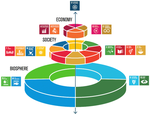
The SDGs are people-centered and planet-sensitive. The arrangement of SDGs with Environment as the base of the three-tiered schematic above, was developed by The Stockholm Resilience Centre and represents economies and societies as embedded parts of the biosphere. Through this framework, SDGs are drivers for the reduction of poverty and inequality; economic growth and job creation; sustainable use of resources and restoration of ecosystems.
5.1. Environmental–economic accounting
Global consultation on the System of Environmental–Economic Accounting (SEEA) Central Framework was completed in 2011 and was adopted by the UN Statistical Commission, at its 43rd Session in 2012, as the first international standard for environmental–economic accounting. The final version of the SEEA Central Framework was published in February 2014. The UN Committee of Experts on Environmental–Economic Accounts has submitted to the UNSD a list of the indicators, which the UN SEEA deem interoperable with the SDG Indicators.
The SEEA contains the internationally agreed standard concepts, definitions, classifications, accounting rules and tables for producing internationally comparable statistics on the environment and its relationship with the economy. Subsystems elaborate on resources including Energy, Water, Fisheries, Land and Ecosystems, and Agriculture. At the current level, regular reporting on SEEA accounts will support monitoring several SDG Goals:
| • | Goal 8: Sustainable economic growth; | ||||
| • | Goal 12: Sustainable consumption and production; | ||||
| • | Goal 15: Sustainable use of terrestrial ecosystems, especially 15.9 integrating ecosystem and biodiversity values into national and local planning and development processes and poverty reduction strategies and accounts; and | ||||
| • | Goal 17: Enhancing capacity building to increase availability of data. | ||||
The primary means for accomplishing this at the national level is for countries to produce selected ecosystem accounts as ongoing statistical processes. The degree to which these accounts follow the SEEA-Experimental Environmental Accounting guidelines will determine the degree to which the results are internationally comparable. An effort to coordinate EO for Environmental Accounting (EO4EA) is currently underway as an Initiative in GEO.
5.2. Intersectional linkages − the 2030 Agenda, MEAs (multilateral environmental agreements) and other agreements
The 2030 Agenda reaffirms all the principles of the Rio Declaration on Environment and Development, the importance of the Universal Declaration of Human Rights, acknowledges that the UNFCCC is the primary international, intergovernmental forum for negotiating the global response to climate change (the SDGs were agreed upon before the COP21 conference and the Paris Agreement), and recognizes that social and economic development depends on the sustainable management of the planet’s natural resources – with a reference to the Convention on Biological Diversity (CBD). The 2030 Agenda also emphasizes that sustainable urban development and management are crucial to the quality of life of people, with a reference to the UN Housing and Sustainable Urban Development Conference.
5.3. MEA
The 2030 Agenda recognizes that inequality and unsustainable consumption and production of resources are byproducts of economic growth and constitute a big challenge in a world of finite resources. National governments are committed to the SDGs and are equally obliged, under existing commitments, to honor MEAs.
The UNEP has assessed MEAs and how they relate to SDG Targets (particularly the ones informing Goal 14, Life below water and 15, Life on land). Categories of biodiversity-related MEAs include The CBD, the Convention on international Trade in Endangered Species of Wild Flora and Fauna, the Convention on the Conservation of Migratory Species of Wild Animals, the Convention concerning the Protection of the World Cultural and Natural Heritage, the International Treaty on Plant Genetic Resources for Food and Agricultures and the International Plant Protection Convention. Chemicals and waste-related MEAs include the Basel Convention on the Control of Transboundary Movements of Hazardous Wastes and their Disposal, the Rotterdam Convention on the Prior informed Consent Procedure for Certain Hazardous Chemicals and Pesticides in international Trade and the Stockholm Convention on Persistent Organic Pollutants. Also included in the assessment are the Rio Conventions – ie the CBD, Aichi Biodiversity Targets, the UNFCCC, the UN Convention to Combat Desertification (UNCCD) and the Regional Seas Conventions. The report indicates that while conventions such as the CBD are mentioned in the preamble to the 2030 Agenda, there is a need for synergies between MEAs and SDGs; it also calls for additional SDG indicators that are more closely related to MEAs.
EO are useful tools for tracking progress towards the CBD Strategic Plan for Biodiversity. The CBD vision is to restore, value and conserve biodiversity for the benefit of all people by 2050. Embedded in the Plan are 20 Aichi Biodiversity Targets. Eleven of the 20 Aichi Targets (Targets 4–15, except Target 13) can be partly or wholly measured using EO products (EO as a tool for tracking progress towards the Aichi Biodiversity Targets, 2015). In 2014 a series of 55 indicators were used in the Global Biodiversity Outlook which presents a mid-term evaluation of progress. One of the conclusions of this evaluation was that many indicators were problematic due to a lack of data standardization, lack of global coverage, low spatial resolution and lack of longtime series for measurements. There are lessons from this experience which should be applied to the SDG process, and standardization of terms is one subject tackled by GEO’s Initiative on BON.
GEO BON has developed a set of Essential Biodiversity Variables (EBV), inspired by the 50 ECV endorsed by the GCOS to support the work of the intergovernmental interface between climate policy and climate science. It is also hoped the EBV will be relevant to the newly formed Intergovernmental Platform on Biodiversity and Ecosystem Services which aims to achieve for biodiversity and ecosystems what the Intergovernmental Panel on Climate Change has achieved for climate.
Examples of EBV derived from remote sensing include Phenology (Start of growing season), Net primary productivity (photosynthetic activity), Nutrient retention (leaf nitrogen retention, leaf phosphorus limitation) and Habitat structure (cover, height, clumping). Examples of EBV requiring in situ data and or modeling include Breed & variety diversity, Species distribution, Population abundance, Migratory behavior, demographic traits, physiological traits, Secondary productivity, Disturbance regime, Ecosystem composition by functional type and Ecosystem extent and fragmentation.
Current challenges to integrated biodiversity monitoring include limitations of technology. To date the global picture has been obtained by Land Cover Imagery supporting GlobeLand 30, the ESA Climate Change Initiative (CCI) (global land cover 2000, 2005 and 2010). Systematic challenges include standardization in EO data and products, providing more long-term opportunities for interdisciplinary collaboration, establishing priorities for EO in biodiversity conservations and designating leadership and institutional oversight.
Opportunities for improvement in biodiversity monitoring are included in upcoming EO missions. These missions have the potential to yield both direct and indirect observations of biodiversity. For example, Sentinel-2 has an optical multi-spectral sensor; the key observation characteristic for terrestrial biodiversity is global plant status and health and Sentinel 2 will deliver data every five days at 10-m spatial resolution providing continuity with the Landsat and Satellite Pour l’Observation de la Terre (SPOT) satellites (Copernicus Citation2017).
5.4. Goals 14 and 15 correspond to the Convention on Biodiversity
Data and knowledge gaps often arise due to difficulties in determining whether a site conforms to the International Union for Conservation of Nature definition of a protected area, and some protected areas are not assigned management categories. Moreover, “other effective area-based conservation measures”, as specified by Aichi Biodiversity Target 11 of the Strategic Plan for Biodiversity 2011–2020, recognize that some sites are beyond the formal protected area network, and while not managed primarily for nature conservation, may nevertheless be managed in ways which are consistent with the persistence of biodiversity which is important (Jonas et al. Citation2014).
5.5. Target 6.6 water-related ecosystems 6.6.1 change in the extent of water-related ecosystems over time.
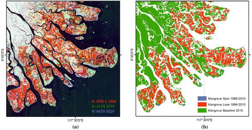
This Indicator includes mainly wetlands defined by the Ramsar Convention as swamp, pond, peat, or water, natural or artificial, permanent or temporary, stagnant or flowing water, including estuaries and marine waters down to 6 m. Current methods of assessment are based on the Wetland Extent Index developed by UNEP WCMC (heterogeneous datasets). Wetland inventory methods are currently jointly developed by Satellite-based Wetland Observation Service (EC H2020 programme) and GlobWetland Africa projects. The methodology for global extent of surface water dynamics is currently being developed. The Custodian Agency is UNEP and the methodology established includes ecosystem categories of wetlands (swamps, marshes, and peats), inland open water (rivers, lakes, and reservoirs), and groundwater aquifers. EO are instrumental in mapping wetland extent: the percentage of change in the extent of wetlands over time can be measured globally by EO looking at vegetation cover, soil moisture and inundation frequency. More robust inventories are expected when using a combination of multi-temporal optical- and radar-derived indicators, and higher frequencies of observations will contribute to more robust monitoring of seasonal dynamics (Figure ).
Figure 7. (a) Mahakam delta, East Kalimantan. L-band SAR temporal composite. Red areas indicate mangrove loss (Credit: JAXA/Ministry of Economy, Trade, and Industry); (b) Corresponding mangrove change map, showing 2010 extent in green and changes between 1996 and 2010 in red (losses) and blue (gains) (Credit: Global Mangrove Watch, 2015).
5.6. MEAs and Land cover
Land cover is the term used to describe the physical material of the Earth’s surface such as forest, wetland, impervious surface, agriculture etc. Land cover is defined as the observed (bio)-physical cover on the Earth’s surface. It includes vegetation and human-made features as well as exposed rock, bare soil and inland water surfaces.
An assessment on the importance of Land Cover to monitor SDG Targets and Goals with the current Indicators shows important data (essential or complementary) needed by 31 Indicators and Land Cover Change data for 9 Indicators. In addition, the Indicators currently listed for Goal 13, climate action and Goal 15, Life on land are not considered sufficient to report progress on specific Targets, additional Indicators are needed.
5.7. The trade off – where indicators are not complementary: Tier III example 9.1.1 proportion of the rural population who live within 2 km of an all-season road
In rural areas across the globe, good transport connectivity through road infrastructure and transport services is essential for achieving progress towards sustainable growth. Population dynamics and environmental sustainability are intrinsically linked, and serve as a cross-cutting theme for the SDGs.
By statistical office surveys, interviewing households, and extrapolating, it is possible to draw conclusions, for example on how close the community is to the nearest road. With the benefit of EO, it is possible not only to monitor distance to the nearest road far more accurately, it is also possible to visualize how to solve the issue of increased road access. Further, remote sensing data can help inform changes in impervious surface cover including paved roads, contributing thus to an enhanced understanding of human–environment interactions in an urbanized environment.
The World Bank, with the support of the UK Department for International Development is devising a new, GIS-based Rural Access Index (RAI) that exploits advances in digital technology to create a more accurate, relevant and cost effective RAI (World Bank Citation2017). Eight countries in Africa and South Asia are currently testing the new methodology and preliminary estimates are available for Kenya and Mozambique. The richer detail in the GIS-based index on road locations and conditions is suggesting policy-relevant conclusions such as location of the construction of new roads.
5.8. Tier III example 15.3.1 land degradation neutrality, proportion of land that is degraded over total land area
The Target to achieve a land degradation neutral world and its Indicator require data on Land Cover and Land Use Change. This represents a classic use of satellite data for land use change detection studies and national statistics. The Custodian agency for this Indicator is the UNCCD. The UNCCD has established a formal Inter-Agency Advisory Group on Indicator 15.3.1 composed of UNCCD, FAO, CBD, UNFCCC, UNDP and UNSD, to develop the methodology and identify data sources for this indicator, in consultation with technical and scientific experts and data providers such as CSIRO and ESA.
The importance of Land Cover is recognized in several international treaties and conventions. Land Cover data is relevant for UNFCCC reporting processes and UNCCD as a custodian agency for SDG indicator 15.3: By 2030, combat desertification, restore degraded land and soil, including land affected by desertification, drought and floods, and strive to achieve a land degradation-neutral world. UNCCD also promotes land cover data to be used in national reporting in UNCCD’s Land Degradation Neutrality (LDN) Target-Setting Programme (TSP).
In 2015, UNCCD initiated a LDN target-setting pilot project with 14 countries from all continents, to help set voluntary targets to achieve sustainable land management, and monitor progress, based on a set of three measurable sub-Indicators: (1) Land Cover and Land Cover Change, (2) land productivity trends and (3) soil organic carbon trends, with the first two global data sets entirely based on satellite EO data. This effort is now continued in LDN-TSP with more than 100 UNCCD countries.
Target 15.3 is recognized as an important vehicle for driving UNCCD implementation which has the LDN achievement among its core strategic objectives for the new Strategic Plan 2018–2030. This framework for SDG 15.3 Target monitoring and 15.3.1 Indicator reporting will help countries implement policy priorities to support land use planning and management; address land degradation issues; plan actions for the conservation, rehabilitation and restoration of land resources; and eventually achieve LDN.
Land Cover also plays a major role in climate change processes addressed in Sustainable Development Goal 13. Deforestation constitutes the second largest anthropogenic source of carbon dioxide to the atmosphere, after fossil fuel combustion. At the same time, changes in land cover may result in changing climate, eg desertification, land degradation loss of biodiversity etc. Agriculture, Forestry and Other Land Use (AFOLU) plays a central role for food security and sustainable development. AFOLU activities lead to both sources and sinks of CO2. AFOLU describes a category of activities which contribute to anthropogenic greenhouse emissions. Used in national GHG inventories, the AFOLU category combines two previously distinct sectors: one being combined Land Use, Land Use Change & Forestry; and Agriculture.
Certain Tier II and Tier III SDG Indicators may not yet be addressed by existing tools or products, the international community is working to produce applications which can be harnessed for the purposes of reporting on SDG Indicators. Reliable observations are crucial to monitor and understand the ongoing processes of deforestation, desertification, urbanization, land degradation, loss of biodiversity, ecosystem functions, water and energy management, and the influence of Land Cover changes on the physical climate system itself (Herold Citation2009).
Datasets for global Land Cover are currently produced at resolutions of between 30 m and 1 km by several space agencies, particularly those participating in the FAO-WMO (World Meteorological Organization)–UNESCO (UN Educational, Scientific and Cultural Organization)–UNEP–ICSU Global Terrestrial Observing System technical panel of the Global Observation of Forest and Land Cover Dynamics. The U.S. Geological Survey has produced 30-m resolution Global Land Cover layers for Global Tree Cover, Global Water (2000–2012) and Bare Ground.
Global datasets of satellite imagery at 30-m resolution have been assembled for selected years (eg 1990, 2000, and 2005), and some regional Land Cover maps have been generated from these. To better quantify changes in Land Cover characteristics, these high-resolution data should also be used for wall-to-wall global mapping at resolutions of 10–30 m (NOAA Citation2017). Maps at this resolution are needed at least every five years over long time periods (several decades) to assess Land Cover change.
The global Land Cover monitoring system integrates information from three common observational scales: moderate-resolution satellite data (eg moderate-resolution imaging spectroradiometer or medium-resolution imaging spectrometer-type satellite sensors); fine resolution satellite data (from Landsat- and SPOT-type satellite sensors), and in situ observations (or very high-resolution remote sensing data). Continuity of observations and consistency for Land Cover characterization is required for all these scales (Herold Citation2009).
Achieving an amalgamated global picture is difficult due to inconsistencies among the different Land Cover map products or change monitoring systems, complicating the scientific community’s ability to successfully synthesize Land Cover assessments on regional and global scales (Herold Citation2009). The UN Land Cover Classification System (LCCS) classifiers provide a comprehensive and flexible framework for thematic Land Cover characterization. LCCS classifiers enable compatibility to be achieved among existing datasets and for future global monitoring systems.
Global collaboration on Land Cover is part of the composite observing system designated as The GCOS (a joint undertaking of WMO, Intergovernmental Oceanographic Commission/UNESCO, UNEP and ICSU), which serves as the climate-observation component of the GEOSS. GCOS focuses on measurement of the ECVs, which are globally agreed upon in definition and methodology of calculation. Land Cover is the Terrestrial ECV.
Collaboration is also organized through the Global Land Cover Network, an international partnership (FAO, UNEP and Italy) for global harmonized and accessible Land Cover data and information; and the Global Observation of Forest Cover and Land Dynamics, a coordinated international effort, run by ESA and Wageningen University, is working to provide space-based and in situ observations of land surface for sustainable management of resources and for a better understanding of the terrestrial carbon budget.
5.9. Land cover: global-scale monitoring in the service of national indicators
GCOS defines Land Cover as an ECV under the global classification of comprehensive observations for the climate system. There are dedicated regional land cover monitoring initiatives such as ESA’s Land cover CCI, but it is difficult to develop global-scale land use products allowing change analysis, needed by the climate modelers, or mitigation and adaptation communities.
Parties of UNFCCC must submit annual national GHG inventories covering emissions and removals of direct GHG from different sectors including estimates of anthropogenic emissions and removals. A three-tiered approach is used for AFOLU: Tier 1 methods are designed to be the simplest and include globally available sources such as Land Cover maps. According to the National GHG Inventory for South Africa ‘in the past year various improvements have been made to the GHG inventory due to the incorporation of more detailed activity data, updated emission factors and more consistent Land Cover maps. The implementation plan calls for actions to generate yearly Land Cover products that allow change assessment at 10–30-m spatial resolution, develop a community consensus strategy and priorities for monitoring to include information on land management in current Land Cover datasets and develop yearly deforestation and degradation at 10–30-m spatial resolution.
The use of Volunteer Geographic Information for Land Cover validation studies is timely. This additional resource seems even more relevant as Google Earth has been used for the recent validation of remote sensing derived products eg, the European forest cover map as well as the latest global Land Cover map GlobCover. Google Earth also allows a wider audience to be involved in a validation exercise (See et al. Citation2016).
In the case that a comprehensive Land Cover layer could be created with more regularity, (China has made one, moderate-resolution imaging spectroradiometer is capable of producing regular Land Cover Layers) this would provide data for SDGs as outlined above, but the problem is finding a location to process the massive amounts of data required. Currently this is possible in a few global centers. Data Cube, an Australian program showing a time series of image data, has shown what is possible when massive computing power is applied to EO data and it is anticipated that the rise of supercomputing centers will continue to support the development of time series imagery.
6. Partnerships and efficient investments
In January 2017, the UNSD along with Statistics South Africa convened the first ever UN World Data Forum. This gathering was designed to bring statistical and other technical communities and disciplines together to improve global statistical practices including support for the 2030 Agenda for Sustainable Development. GEO participated in numerous sessions and plenary presentations. Geospatial information along with EO data became an informal theme for many of the sessions. Many of the delegates from statistical organizations and other stakeholders remarked on the emphasis that geospatial data had during the program.
Under the Sustainable Goal 17: Revitalize the global partnership for sustainable development Targets on Technology and Capacity building are directly relevant to the EO community:
6.1. Technology
| • | Enhance North–South, South–South and triangular regional and international cooperation on and access to science, technology and innovation and enhance knowledge sharing on mutually agreed terms, including through improved coordination among existing mechanisms, in particular at the UN level, and through a global technology facilitation mechanism; | ||||
| • | Promote the development, transfer, dissemination and diffusion of environmentally sound technologies to developing countries on favorable terms, including on concessional and preferential terms, as mutually agreed; and | ||||
| • | Fully operationalize the technology bank and science, technology and innovation capacity-building mechanism for least developed countries by 2017 and enhance the use of enabling technology, in particular information and communications technology. | ||||
6.2. Capacity building
| • | Enhance international support for implementing effective and targeted capacity-building in developing countries to support national plans to implement all the SDG, including through North–South, South–South and triangular cooperation. | ||||
GEO and its partners have a role to enable use of EO in support of the 2030 Agenda by directly addressing the Strategic Development Goal 17 on Partnerships. Partnerships are vital to address the key cross-cutting issue of “global data” particularly given that some data are not available at national level, but are available at global levels.
Geospatial information is able to provide enabling methodologies and processes for disaggregation, for example at sub-national level and in particular differentiating between rural and urban populations. This aspect is crosscutting for all SDG indicators, not just those which can be measured using EO.
Partnerships are also required to address cross-cutting issues relating to alternative data sources, including crowd sourced data, citizen science data and volunteered geographic data.
Access to EO is not an end in and of itself – interoperability is necessary, as specified in the AAAA on financing the SDGs:
Data access alone, however, is not enough to fully realize the potential that data can offer … We should endeavor to ensure broad access to the tools necessary to turn data into useful, actionable information. We will support efforts to make data standards interoperable, allowing data from different sources to be more easily compared and used.
This process is underway within GEO by building the GEOSS and the data standards for the GCI. The GEOSS Portal is one of a few global systems for accessing EO data, accessing government, organizational and private sector data for remote sensing, in situ and atmospheric data.
A global movement is in full swing in terms of EO applications for the SDGs. The main actors: GEO; UNGGIM; Sustainable Development Solutions Network (SDSN); Global Partnership for Sustainable Development Data (GPSDD) for which GEO serves as Anchor Partner and is also a member of the Interim Steering Committee and Working Groups on Global Collaboratives, Data Principles and Protocols, and Data Architecture); UNSD, SDSN, the International Institute for Sustainable Development (IISD) and others will need to work together to enhance efficiency, avoid duplication of efforts, identify gaps and ensure good governance. Roles must be clearly defined as competition, especially for funding, will not enhance collaboration.
The range of actors involved in the provision and use of EO is changing. Once the sole domain of governments, satellites are increasingly being launched by the private sector (eg Digital Globe, Planet, UrtheCast). One solution to address the data gaps is to adopt open data policies that facilitate broad and open access to existing data. Open data policies need to be supported with mechanisms for easy access and easy discovery of data (Joel Citation2016).
Here we summarize some partnerships and portals in support of environmental data for the SDGs (Table ).
Table 2. Selected partnerships and portals in support of environmental data for the SDGs.
7. Global collaboration for improved application of EO for the SDGs
The UN Global Working Group on Big Data for Official Statistics Task Team, the Committee on Global Platform for Data, Services and Applications is mandated to build on best practices of public and private Big Data initiatives and offer:
the technology infrastructure and a network for data innovation to the official statistical community, the Global Platform could address the needs for (a) a global hub for official statisticians, data scientists and domain experts from the public and private sector to exchange ideas and methods for processing, analyzing and visualizing Big Data; (b) a global hub for storing Big Data, and related processing, analyzing and visualizing methodology, and services and applications for continuous development and re-use; (c) a global hub for demonstrating the value of Big Data in better decision making through official statistics through pilots and case studies; and (d) a global resource hub for training materials and workshops on Big Data for capability building. (Big Data UN Global Working Group Citation2016)
It is imperative that platforms such as the one referred to above make use of existing platforms such as GEO’s GCI. This platform and others should build on best practices of public and private Big Data initiatives of which there is a plethora.
Several other global and regional frameworks – including CEOS, the Global Spatial Data Infrastructure, the UN Platform for Space-based Information for Disaster Management and Emergency Response (UN Spider), European Environment Agency and the International Center for Integrated Mountain Development are developing and facilitating access to geospatial information and knowledge.
New data sources and technologies for data collection will need to be explored, including through partnerships with civil society, the private sector and academia. The integration of geospatial information and statistical data will also be key for the production of a number of indicators.
A key but evolving aspect of the SDGs is the means of implementation. Many developing countries emphasize the importance of international assistance while developed countries focus more on domestic financing and the private sector. Prioritization of certain goals over others may be driven by the means of implementation. Capacity-building activities to strengthen national SDG monitoring and reporting must recognize the critical importance of supporting developing countries in strengthening the capacity of national statistical offices and data systems to ensure access to accurate, timely and reliable data. One solution may be flexible methodologies for countries to enter monitoring with national capacity and resource availability, start simple and advance progressively as capacity and resources increase, which is often referred to as progressive monitoring (Mark, Bengtsson, and Akenji Citation2016).
The GEO Initiative on the use of EO to measure and monitor the SDGs has as its primary objective to integrate EO and geospatial information into national development and monitoring frameworks for the SDGs. It aims to leverage EO to support the implementation, planning, monitoring, reporting, and evaluation of the SDGs and their normative societal benefits. Activities within the Initiative underscore and support GEO’s emphasis on sustained observations, open data, and capacity building.
The GEO Initiative is launching a series of pilot projects to apply and test uses of EO to support the assessment and tracking of the SDGs, including integration with national statistical accounts for the indicators. Projects include efforts to support qualitative and quantitative evaluation on the benefits of EO to enable societal benefits. Pilot project activities focus on specific countries and SDG Indicators, with attention to the ability to scale a method to multiple nations or stakeholders on a regional or global scale through sharing smart practices, providing guidance, and encouraging consistent approaches and quality standards.
Capacity Building activities draw on, and contribute to, GEO’s established capacity building activities and expertise and include virtual and physical activities, such as trainings, webinars, joint projects, applied research, and workshops, among many other successful capacity building practices. Data and Information products support GEO’s efforts to promote and encourage open data policies. Outreach consists of creation and maintenance of a portfolio of materials, such as case studies, stories, articles, and web features.
8. Conclusions
The benefits of using EO to monitor and achieve the SDG are numerous by providing:
| • | Synoptic views of the Earth’s surface; polar orbiting, sun synchronous EO sensors observe wide swaths of the Earth in one pass, acquiring and storing large amounts of Earth surface imagery under constant conditions of solar illumination; | ||||
| • | Regular and repeatable observations; polar orbiting EO satellites orbit the Earth several times per day allowing consistent and systematic surface observations of the entire Earth surface (with the exception of the Earth’s poles); | ||||
| • | Multi-annual time series of observations; since the 1970s the average operational lifetime of an EO mission has almost tripled to today’s average mission lifetime of 8.6 years (Belward and Skoien Citation2015) enabling more stable and continuous observations from the same sensor over several years or more; | ||||
| • | Cost-effective means for monitoring remote and inaccessible areas; EO satellites are designed to observe any location on the Earth’s surface at some time in their orbit, albeit with some constraints around polar regions, permitting observation of areas otherwise inaccessible for ground-based surveys; and | ||||
| • | Airborne, ocean-based and in situ sensors directly contribute EO data vital to report on essential variables, as well as providing important verification to remote sensing and modeling. | ||||
There are numerous difficulties locating quality cross-national time series data and greater difficulties have arisen for environmental indicators specifically. Environmental monitoring requires a full breadth of satellite data available with key datasets around temperature, ice extent, sea level, Land Cover change, etc.
The spatial dimension in the SDG is clear for a number of the goals, especially Goal 2, Hunger; Goal 11, Cities; and Goal 15, Ecosystems. Use of EO to measure and achieve these goals introduces the ability to visualize the data, which in turn allows decision-makers to identify solutions to ensure inclusion. Harnessing investments in EO as well as investments in the science–policy interface lead to more accurate data and information, better knowledge and improved decision-making so that no one is left behind.
Global agreements on standards should be encouraged and can be strengthened through a focus on the SDGs. The global meteorological community has reached agreement on certain ECVs and what is being measured and how, but there remains much to be done to agree upon common standards.
Land cover has great potential to respond to policy applications and would benefit from more harmonization of global efforts. Regular time-series data such as the Data Cube program has demonstrated the power of data for visualization of environmental change.
In the years directly following global adoption of the SDG Targets and Indicators it is inevitable that there will be a flurry of portals, platforms, grids and hubs scrambling to meet the data needs of reporting countries. GEO has spent the last decade building the common infrastructure of the GCI in the global context and is striving to ensure linkages are made with new platforms.
A global movement to put data in the hands of those who need it, to make sure no one is left behind, is championed by GEO through its activities to make EO data open and accessible. Open data refers to data that is open by default and strives for certain qualities such as being timely and comprehensible, accessible and usable, comparable and interoperable. GEO supports open data sharing with its Data Sharing Principles (GEO Citation2015). How the information derived from EO is displayed is a new phenomenon which requires the brilliance of visualization experts. The core data, collected by governments at tax payers’ expense, however, must and should remain open and free to the user.
Sharing EO data brings a multitude of environmental and economic benefits. Opportunities from open data include supporting broad economic benefits and growth, enhancing social welfare, growing research and innovation opportunities, facilitating knowledge sharing among a new generation of scientists and effective governance and policy-making.
Within this framework innovations such as Citizen Science are examined for the contribution they can bring to more rigorous EO data collection. The context of the data revolution means that an exponential growth in information requires data management to ensure accessibility of the data.
GEO’s GEOSS hosts EO and environmental data from GEO Members and Participating Organizations, and GEO encourages all Members to provide open access and unrestricted use of data in GEOSS.
Notes on contributors
Katherine Anderson communicates how free and open EO data can be used to benefit society. She led global campaigns for The Global Fund to Fight AIDS, TB and Malaria, the Water Supply and Sanitation Collaborative Council and the UN Development Programme and has worked on the ground in more than a dozen countries in Africa and Asia. She worked as a broadcast journalist for the BBC and holds a Master’s degree in International Affairs from the Graduate Institute, Geneva and a Human Rights Law Diploma from Geneva University.
Barbara Ryan leads the Secretariat in coordinating the activities of 103 member states and the European Commission and 109 participating organizations that are integrating EO so that informed decisions can be made. Before becoming GEO Director in July 2012, she served as the director of the WMO Space Programme and was the associate director for Geography at the USGS. She holds a Master’s degree in Geography from the University of Denver, a Master’s degree in Civil Engineering from Stanford University and has been awarded an honorary doctorate of science degree from the State University of New York at Cortland.
William Sonntag is currently assigned to the GEO Secretariat. He has managed a variety of initiatives for the US Environmental Protection Agency Office of International and Tribal Affairs, Office of Environmental Information. He has co-convened the Ecoinformatics International Technical Collaboration process with partners including USGS, US Department of Energy, US Centers for Disease Control and Prevention, US National Science Foundation, UNEP, the European Environment Agency (co-convener), European Commission Directorates General for Environment and Research, JRC, Organization for Economic Co-operation and Development. Primary collaboration topics include advanced computer science and data system interoperability, indicators, and global assessments including sustainability and environmental and Earth observations systems.
Argyro Kavvada is an associate in Science Program and Project Management at Booz Allen Hamilton. Her work focuses on supporting the NASA Earth Science Division’s Applied Sciences Program and its engagement with the interagency US-GEO and the international GEO, with the key objective of realizing the potential of EO for achievement of the 2030 Agenda for Sustainable Development. Argyro received a doctorate and a Master’s degree in Atmospheric and Oceanic Science from the University of Maryland, College Park, a Master’s degree in Applied Mathematics and Statistics from Georgetown University, and a Bachelor’s degree in Physics from the Johns Hopkins University.
Lawrence Friedl serves as the director of the NASA Earth Science Division’s Applied Sciences Program. The Program supports efforts to discover and demonstrate innovative and practical applications of Earth science by public and private sector organizations. He has been with the NASA Applied Sciences Program since 2002 and served as a program manager for several applications themes. Prior to joining NASA, Lawrence worked at the US Environmental Protection Agency, focusing on geospatial applications, and he served as a Space Shuttle Flight Controller in NASA’s Mission Control Center for 15 missions. Lawrence received a Master’s degree in Public Policy from Harvard University’s Kennedy School of Government, and he received a Bachelor’s degree in Mechanical & Aerospace Engineering from Princeton University.
Acknowledgments
This article built on the work of the members of the GEO Initiative on EO in service of the 2030 Agenda for Sustainable Development. In particular, the authors wish to thank Chu Ishida of the JAXA, Eduardo De La Torre of the National Institute of Statistics and Geography, Mexico, Giovanni Rum, GEO Secretariat and Marc Paganini of the ESA.
References
- AAAA. 2015. “The Addis Ababa Action Agenda of the Third International Conference on Financing for Development.” http://www.un.org/esa/ffd/ffd3/wp-content/uploads/sites/2/2015/07/Addis-Ababa-Action-Agenda-Draft-Outcome-Document-7-July-2015.pdf.
- Adams, B., and K. Judd. 2016. “Silos or System? The 2030 Agenda Requires an Integrated Approach to Sustainable Development.” https://www.globalpolicy.org/home/271-general/52874-silos-or-system-an-approach-to-the-2030-agenda.html.
- Belward, A. S., and J. O. Skoien. 2015. “Who Launched What, When and Why; Trends in Global Land-cover Observation Capacity from Civilian Earth Observation Satellites.” ISPRS Journal of Photogrammetry and Remote Sensing 103 (5): 115–128. doi:10.1016/j.isprsjprs.2014.03.009.
- Big Data UN Global Working Group. 2016. https://unstats.un.org/bigdata/.
- Blanc, D. L. 2015. “Towards Integration at Last? The Sustainable Development Goals as a Network of Targets.” Sustainable Development 23 (3): 176–187.10.1002/sd.v23.3
- Copernicus. 2017. “Application Domains.” http://www.copernicus.eu/main/application-domains.
- GEO. 2015. “Data Sharing Principles.” http://www.earthobservations.org/geoss_dsp.shtml.
- GEO DAB. 2017. “GEO DAB STATISTICS.” http://statistics.geodab.eu/gi-stat/stats/.
- Herold, M. 2009. “(ETOS) Assessment of the Status of the Development of the Standards for the Terrestrial Essential Climate Variables: T9 Land Cover.” http://www.fao.org/gtos/ECV-T09.html.
- ICSU and ISSC. 2015. “Goal 6, Review of Targets for the Sustainable Development Goals: The Science Perspective.” http://www.icsu.org/publications/reports-and-reviews/review-of-targets-for-the-sustainable-development-goals-the-science-perspective-2015/SDG-Report.pdf.
- IUCN (International Union for Conservation of Nature) 2016. “A Global Standard for the Identification of Key Biodiversity Areas.” https://portals.iucn.org/library/node/46259.
- Joel, B. C. 2016. “Transforming Our World: Achieving the 2030 Agenda for Sustainable Development through Strategic Project Management.” IPMA Expert Seminar, Zurich, Switzerland, February 18−19.
- Jonas, H. D., V. Barbuto, H. C. Jonas, A. Kothari, and F. Nelson. 2014. “New Steps of Change: Looking beyond Protected Areas to Consider Other Effective Area-based Conservation Measures.” Parks 20 (2): 111–128.10.2305/IUCN.CH.2014.PARKS
- Mark, E., M. Bengtsson, and L. Akenji. 2016. “An Optimistic Analysis of the Means of Implementation for Sustainable Development Goals: Thinking about Goals as Means.” Sustainability 8 (9): 962–985. doi:10.3390/su8090962.
- Nabarro, D. 2016. “Address to Diplomats and United Nations System Principals at the UN Office in Geneva.” http://www.itu.int/en/council/2016/Documents/Nabarro-address-HOA.pdf.
- National Geospatial Advisory Committee, Landsat Advisory Group. 2014. “The Value Proposition for Landsat Applications.” http://www.fgdc.gov/ngac/meetings/december-2014/ngac-landsat-economic-value-paper-2014-update.pdf.
- NOAA. 2017. “GCOS Essential Climate Variable Data and Information Access Matrix.” https://www.ncdc.noaa.gov/gosic/gcos-essential-climate-variable-ecv-data-access-matrix.
- See, L., P. Mooney, G. Foody, L. Bastin, A. Comber, J. Estima, S. Fritz, et al. 2016. “Crowdsourcing, Citizen Science or Volunteered Geographic Information? The Current State of Crowdsourced Geographic Information.” ISPRS International Journal of Geo-Information 5 (5): 55. doi:10.3390/ijgi5050055.
- UNGGIM and GEO. 2015. “Unleashing the Power of ‘Where’ to Make the World a Better Place: How Geographic Information Contributes to Achieving the Sustainable Development Goals.” http://www.earthobservations.org/documents/meetings/20150422_geo_un_ny/20150422_geo_un_ny_flyer.pdf.
- UNICEF. 2016. “Clear the Air for Children.” https://www.unicef.org/publications/index_92957.html.
- UNSD. 2016. “Sustainable Development Goals Report.” https://unstats.un.org/sdgs/report/2016/.
- Weitz, N., M. Nilsson, and M. Davis. 2014. “A Nexus Approach to the Post-2015 Agenda: Formulating Integrated Water, Energy and Food Sustainable Development Goals.” SAIS Review of International Affairs 34 (2): 37–50.10.1353/sais.2014.0022
- WHO (World Health Organization) 2016. “Global Burden of Disease.” http://www.who.int/topics/global_burden_of_disease/en/.
- World Bank. 2017. “Rural Access Index.” http://data.worldbank.org/data-catalog/rural-access-index.