
ABSTRACT
The evolution of terminology in a given field of science and technology is a good indicator of the context in which inventions originated and how concepts have evolved. This is the case of photogrammetry, remote sensing and related methods, whose terminology evolved, first under the influence of the early inventors Laussedat and Meydenbauer, in French and German, respectively, and then in English and other languages as an international professional community developed. The development of space remote sensing and analytical photogrammetry led to the modification of old concepts and the renewal of terminology, and more recently, the advent of digital photography has blurred the boundaries between different fields and the meaning of the terms. This article proposes an analysis of the evolution of technical terms through the Google Ngram Viewer tool, which allows the visualization of the occurrence of terms in documents accessible on the web. Despite its biases, this tool allows an interpretation of the evolution of the terminology over a long period of time, as well as a comparison of the evolution observed in the different languages. In particular, it makes it possible to highlight the periods when these methods were very popular, as well as a recent decline in the use of classical terms such as photogrammetry and remote sensing in favor of a new vocabulary, due to the blurring of boundaries between disciplines and to the emergence of new solutions related to UAVs, computer vision, etc., which have renewed the potential of classical methods.
1. Introduction
Many authors have studied the process of creation and evolution of specialized terms in a scientific or technical community, as well as their translation between languages and their dissemination to the general public (Budin Citation2001; Picht Citation2011). The evolution of the terminology is interesting to inform us about the real evolution of technological developments, but also about the influence of inventors and the appropriation or new concepts and devices by their potential users. Like other technical fields, photogrammetry and remote sensing have required specialized terms, and although the terms photogrammetry and remote sensing have been the most widely used terms for decades to designate image-based 3D surveys and Earth observation from space, respectively, their initial adoption has not been immediate, their meaning has not always been a consensus, their use has varied over time, and there has even been some decline in recent years, although the actual use of these techniques remains very important.
The availability of very large quantities of texts on the web and social networks, as well as the development of powerful data mining tools, offer unsuspected possibilities (Aggarwal and Zhai Citation2012). In this paper, we have studied the evolution of the terms photogrammetry and remote sensing in the technical documentation available in digital form. We used the Google Ngram Viewer tool which, despite its biases, is very easy to use and allows an expressive display of the evolution of a word over a period of time (https://books.google.com/ngrams/info#). The main parameters chosen by the user are the period of time, the language and a smoothing factor. An option “case sensitive” can also be activated if needed. The Y-axis is the occurrence of the word expressed is percents (i.e. the percentage of the word searched among all the words found in the available documents). It is always a very small percentage, and the relevant information is not this value in itself. Indeed, the aim of these graphical results is to describe the temporal evolution of a word and to compare the evolution of several words.
The general context of technical terminology is briefly addressed in the next section. Then, the history of the terms photogrammetry and remote sensing and an analysis of their evolution based on Ngram Viewer outputs are presented and discussed.
2. Technical terms over time
The science of terminology is a branch of linguistics which notably studies how a professional community creates new terms and uses them to communicate about new concepts (Pitch Citation2011). Understanding these processes is essential for communicating about correct concepts and making rigorous translations, but also because research needs to be supported by an appropriate vocabulary. More generally, a concept cannot be constructed by the human mind without relying on a word. Just as we name people, places and objects of everyday life, it is necessary to name discoveries: new territories discovered by explorers, stars, craters of the Moon, animal and plant species, etc. The case of natural phenomena discovery is slightly different. Like the abstract concepts which the Greek philosophers defined and named during Antiquity, the natural phenomena that the scientists of the last centuries (from Galileo to Darwin) have named to explain them, are not strictly speaking human creations, but their development has required efforts of abstraction and experimental protocols that can be typically found in the process of invention rather than in that of discovery. The Age of Enlightenment and especially the Industrial Revolution have encouraged new inventions in many technological fields. Inventions must also be named, for the same reasons as discoveries (i.e. to manipulate the right concepts) but also for the invention to be appropriated by the inventor, for whom the new term acts as a signature. In some cases the invention can clearly be attributed to one inventor and it is therefore easy to name, like Fermat’s conjecture (1637), Cugnot’s « fardier à vapeur » (1770) or the Rubik’s cube (1974). In many cases, however, the invention is not isolated, it appears during a period of intense intellectual effervescence in which competition and collaboration coexist, so that multiple terms may appear to designate the same concept, often synonymous, as in the case of aviation (Guibert Citation1965) and more recently astronautics (Guibert Citation1967). The choice of terms can also have geopolitical connotations such as in the case of astronaut and cosmonaut, two synonymous terms used in the 1960s by the American and Soviet space agencies, respectively. This was also the case for photogrammetry.
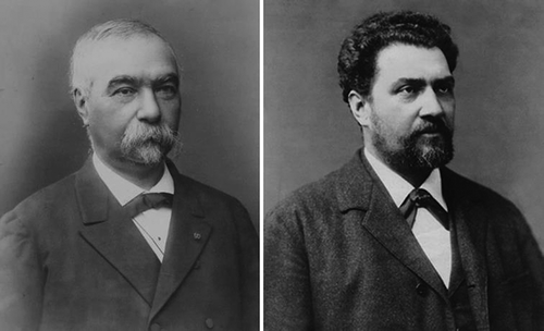
Photogrammetry originated with very similar approaches from the pioneering works of Laussedat in France (Polidori Citation2020) and Meydenbauer in Germany (Albertz Citation2007) about 10 years apart, i.e. around 1860 and 1870, respectively (). They called this technique métrophotographie in French and Photogrammetrie in German, respectively. Beyond the difference between languages, this method of surveying arose in different professional contexts, since Laussedat was a military officer in charge of the recognition of borders and the survey of fortifications, while Meydenbauer was an architect in charge of the documentation of cultural heritage. Moreover, there were no obvious criteria to create a name for the new concept, except building neologisms with greek radicals like in many scientific and technical fields. Therefore, there was no reason for giving the same name to this new technique on both sides of the Rhine river in spite of very similar approaches. If we also consider that various other terms have been proposed in both France and Germany and that photogrammetric experiments have also taken place in countries where other languages were spoken (Italy, South Africa …), it is obviously a very heterogeneous terminology that has existed at the end of the 19th century to designate the surveying method based on photographic images. It is difficult to identify different approaches in clear categories within this linguistic confusion, especially as innovations continued to follow one another such as the application of the principle of stereoscopy for the design of the first stereoplotters. However, while the equipment was given different names as innovations were made (such as Pulfrich’s stereocomparator, Von Orel’s stereoautograph and many others later), the general term photogrammetry gradually became the standard in all European languages at the beginning of the 20th century. This evolution lasted several decades. Concepts needed to be clarified, to which Laussedat contributed with end-of-life writings, and the scientific community needed to organize itself to exchange in order to clarify concepts, which was facilitated when E. Doležal created the International Society for Photogrammetry (ISP) in 1910 (Konecny Citation1985). It should be noted that the scientific community was relatively small and closed, little influenced by the creativity of the press or the general public so that the evolution of terminology was not disrupted by media pressure or literature as aviation and astronautics might be. It is therefore the professional community itself that has forged its own terminology. The history of this terminology is explained in the following section, where we analyze the evolution of the use of the term photogrammetry in different languages, from its cohabitation with the synonym term of French origin metrophotography, to its cohabitation with the remote sensing terminology and with the recent developments of computer vision and other digital methods.
Figure 1. Aimé Laussedat (1819–1907, left) and Albrecht Meydenbauer (1834–1921, right), inventors of similar methods for surveying based on photographic images they called métrophotographie in French and Photogrammetrie in German, respectively
3. Photogrammetry and related terms tracked over two centuries
3.1. From metrophotography to photogrammetry
When Laussedat began his career as a military topographer, responsible for surveying fortifications and mountainous landscapes, he soon had reasons to deplore the laborious and imprecise nature of traditional methods. When he was a student in 1839, he had met Arago who had convinced him of the potential of photography for many applications such as archeology and topography. Using photography to draw up plans thus became a goal that Laussedat pursued throughout his life.
At the beginning of the history of photography, the first variants of this technique gave birth to a varied terminology (heliography, photoengraving, physautotype, daguerreotype, calotype …), and the term photography (from photo = light/graphic = writing) ended up being adopted. The first photographic camera which was successful in France and then abroad was the daguerreotype, patented in 1839. But when Laussedat considered its application to topography around 1845, it was still an embryonic technique (optical lenses were primitive with distortions and narrow angular fields, and the equipment was too heavy and bulky to be easily transported in the field). Therefore, in the meantime, he had to content himself with using hand-drawn perspective views, a method already used by the French hydrographer Beautemps-Beaupré at the end of the 18th century. In order to entrust the surveying operations to operators with no talent for drawing, Laussedat invented an instrument using the camera lucida, with a device to guarantee a rigorous perspective geometry and with a telescope for measuring from afar. He called this instrument télémétrographe, and this method, iconométrie (iconometry, i.e. measurement in images). It should be noted that the term iconometry, although never very abundant as it was soon eclipsed by terms related more specifically to photography, remained in regular use and experienced a revival of interest at the end of the 20th century with the diversification of sources of imagery, not necessarily photographic ().
Figure 2. Occurrences of the French terms iconométrie and métrophotographie (1840–2019)
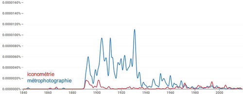
At the same time as he was surveying fortifications using iconometry with a telemetrograph, Laussedat was trying to convince his military hierarchy to test photography. In 1852 the army provided him with a daguerreotype and he began to make tests (Laussedat Citation1859) which would lead to the first demonstration in real conditions in 1861. He named this technique with the French term métrophotographie (i.e. measurement in photographs). According to Ngram Viewer (), this term had rare occurrences from 1844 to the 1880s, which is the period during which Laussedat was active, possibly due to the lack of interest his method had aroused with French military authorities, and perhaps because some publications of that time were not correctly referenced. Many citations appeared in the 1890s. At that time Laussedat, who became an academician in 1894, published many summaries of his work as well as testimonies in French on its implementation abroad (Italy, Germany, Canada, Russia, etc.). It was also the time when French-speaking topographers were implementing metrophotography in major projects, such as the Vallot cousins in the Mont-Blanc massif and Deville in Canada (Polidori Citation2019).
The main attempts to use photographic images for surveying have been summarized by Grimm (Citation2007) with indication of the names given to this technique by the different inventors:
Planchette Photographique (CHEVALLIER),
Ikonometrie/Metrophotographie (LAUSSEDAT),
Photometrographie/Photogrammetrie/Messbildkunst (MEYDENBAUER),
Photographometrie (PORRO) and
Photographische Goniometrie/Phototopographie (PUJO & FOURCADE).
It is interesting to note the diversity of terms used to refer somehow to the same technique. In this context, the one who imposed the term that was to go down in history is the German architect Albrecht Meydenbauer. In the 1860s, Meydenbauer began to use photography for surveys of historical buildings (Albertz Citation2001). According to Grimm (Citation2007) the German geographer Otto Kersten suggested he use the term Photogrammetrie rather than Photographometrie, and the term Photogrammetrie first appeared in 1867 in an unsigned publication whose authorship was attributed to Meydenbauer in 1892. The use of this term started slowly but never waned in the German-speaking photogrammetric community (). Note that the two terms métrophotographie and Photogrammetrie are formed from the same three greek radicals, actually two plus one, i.e. photograph and metro (measurement).
Figure 3. Occurrences of the German term Photogrammetrie (1840–2019)
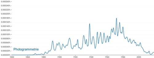
While Laussedat had no support from the French military authorities, Meydenbauer received strong support from the imperial authorities in Germany, which undoubtedly reinforced the development and applications of photogrammetry in German-speaking countries (Prussia, Austria, Switzerland). It also reinforced the use of the term photogrammetry. However, the institute created in Berlin in 1885 to carry out photogrammetric surveys of cultural heritage, the world’s first in this field, was called Königlich Preussische Messbildanstalt. This indicates that at that time, the name of this new technique was not yet stabilized, even in Germany.
At the beginning of the 20th century, the germ of an international community was structured around Doležal when the first two national societies were founded in Austria (1907) and Germany (1909). The ISP was founded in 1910 and the first three congresses were organized in Vienna (1913), Berlin (1926), Zurich (1930), i.e. in three German-speaking countries. In addition, it was from the industries of these countries that the first photogrammetric restitution instruments came out, because even if Deville, in Canada, proposed in 1896 a “stereoscopic device for the construction of topographic plans”, it was Pulfrich who designed the first industrial stereocomparator, and Von Orel, the stereoautograph that was to be used for several decades. In this context, the German term Photogrammetrie came into force at the start of the 20th century, and its English translation photogrammetry later gained acceptance around the world, when English would become the international communication language.
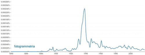
The French term métrophotographie continued to be used in France when a “section Laussedat” was created in 1908 within the “Société Française de Photographie”, and then during the interwar period, perhaps under the influence of a patriotic feeling that may have caused a rejection of the German term. But this resistance was in vain, and even in France, the term photogrammétrie eventually came to be used in the 1930s, as shown in . For example, the “Bulletin de Photogrammétrie” was created in France in 1931; when General Perrier, President of the ISP, hosted the 4th Congress in Paris in 1934, it is the term photogrammetry that dominated this event; and a chair of photogrammetry was created in 1937 in the Conservatoire National des Arts et Métiers, of which Laussedat had been the director in the late 19th century (Ragey Citation1952). The term fotogrammetria was also very successful in Italy on the eve of World War II (), probably for having received a promotion due to the ISP Congress of Rome in 1938.
Figure 4. Occurrences of the French term photogrammétrie (1840–2019)
Figure 5. Occurrences of the Italian term fotogrammetria (1840–2019)
3.2. Photogrammetry and remote sensing
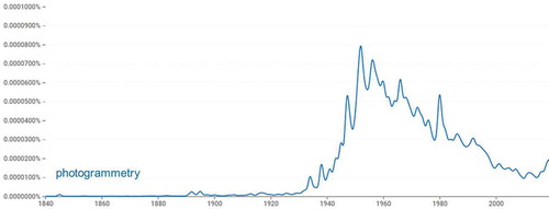
After World War II, official aerial photography campaigns were organized systematically throughout the world, professional photogrammetrists were trained and the photogrammetric restitution was organized in a spirit of industrial production to enable the mapping of huge areas. The terms photogrammétrie and Photogrammetrie were still widely used (besides, French and German were, along with English, the official languages of the ISP). However, although the production of stereoplotters remained predominantly European, the United States, which hosted the ISP Congress in Washington in 1952, became an influential nation in the development of methods and applications, followed by other non-European countries such as Japan, China, Australia, Russia, Canada among others. With the development of an international scientific community the English translation photogrammetry was increasingly used until the 1960s, before declining for reasons which we attempt to explain below ().
Figure 6. Occurrences of the term photogrammetry (1840–2019)
In the 1960s, remote sensing from space began to develop. At its beginnings, it followed a merely physical approach, in which each pixel is characterized by a flow of energy that has to be related to the physical properties of the planet. As recalled on the web page of the International Symposium on Remote Sensing of Environment, the first International Symposium on Remote Sensing of Environment was first convened in 1962 in Ann Arbor, Michigan. [It] brought together scientists from around the world to exchange technical information on an emerging technology called remote sensing, a technology which provided the capability of viewing the Earth from high-altitude aircraft and, ultimately, spacecraft. The same approach of remote sensing was addressed when the First Annual International Geoscience Electronics Symposium was organized in Washington by the IEEE Geoscience Electronics Group, in April 1969.
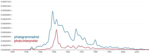
The first remote sensing satellite called TIROS (Television Infrared Observation Satellite Program) was launched in 1960 for meteorological application using TV cameras (Vaughan and Johnson Citation1994). As shown in , the early images acquired from space could hardly be considered as iconometric data, and they were unsuitable for cartographic applications. Remote sensing, therefore, remained distant from the professional world devoted to images, which had developed and organized in the 1950s (). In this professional community, photogrammetrists made geometric measurements for topographic applications, while photo-interpreters used colors (gray levels at first), textures and context to interpret image content and identify topographic objects.
Figure 7. Examples of typical imagery provided by Earth observation satellites half a century apart: TIROS (1960, left), Pleiades (2012, right)
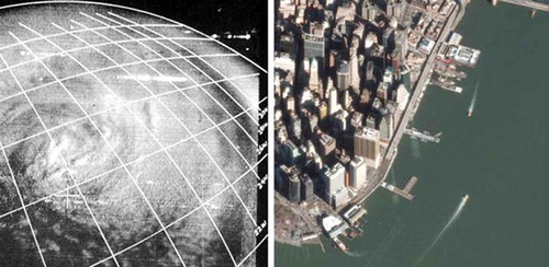
Figure 8. Occurrences of the terms photogrammetrist and photo-interpreter (1920–2019)
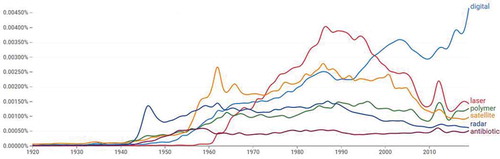
The innovations that emerged around 1960 were often the result of the intense technological research carried out during and after World War II. Indeed, truly new concepts had appeared between 1940 and 1960. shows that in the space of a few years, terms such as satellite, radar, laser have become widely used, as has the general adjective digital. This explosion of new technological concepts has occurred in many other fields, as also illustrated by the increasing use of terms such as polymer and antibiotic at the same time. All of these new developments have taken place in a very short time. For example, it is interesting to note the concomitance of the launch of the first artificial satellite (Sputnik) and the fabrication of the first analytical stereoplotter by Helava during the same year (1957).
Figure 9. Innovations after World War II: occurrences of the terms digital, laser, polymer, satellite, radar and antibiotic (1920–2019)
With the improvement of spatial resolution (the first Landsat satellite was launched in 1972 with the MSS sensor providing 68 × 83 m resolution images), the images could be used for cartographic applications and it became relevant to express requirements for image geometry. Satellite images allowed photogrammetrists and photo-interpreters to do the same work as with aerial photography, but at a different scale, and photogrammetric skills and tools became useful for satellite image processing. From then on, photogrammetry and remote sensing came together into the same broad discipline. As early as 1971, the journal Photogrammetric Engineering became Photogrammetric Engineering and Remote Sensing. The ISP became ISPRS (International Society for Photogrammetry and Remote Sensing) in 1980 and the same convergence between photogrammetry and remote sensing could be observed in other countries of the world.
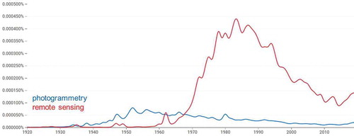
The term remote sensing which already existed logically developed and it became more meaningful when non-photographic images began to be used regularly, in particular non-visible (optical infrared, thermal, radar, etc.). shows that from the 1970s the term “remote sensing” was used much more than “photogrammetry”. We can suggest two explanations for this difference:
Figure 10. Occurrences of the terms photogrammetry and remote sensing (1920–2019)
- The community of remote sensing users was very diverse (geographers and land planners as well as researchers in geology, forestry, agriculture, oceanography, etc.) and this diversity multiplied the opportunities for using the term remote sensing.
- In these different fields, the images were mainly used by the academic community, which has a great habit of publishing, while the photogrammetric community was mostly dedicated to developing and implementing photogrammetry in civil or military mapping agencies or in private companies, whose objective was to produce topographic maps and not to write books.
The term remote sensing became established much more quickly and surely than photogrammetry at the beginning of the century. By the 1970s, English had already become the dominant language in international communication, and since space missions are by nature global in scope, remote sensing was inevitably discussed in international exchanges, which was not the case with photogrammetry in its early days. Moreover, the photogrammetric community was not yet structured in 1900, whereas in 1970–80, scientific exchanges had become frequent, and the remote sensing community could rely on existing scientific societies such as IEEE and ISP, where it was hosted by engineers in electronics and photogrammetry, respectively.
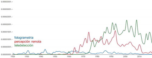
The evolution of the term remote sensing is similar to that observed in other languages. In French, the term télédétection became widespread in the 1970s (), and the preparation of the SPOT space mission (launched in 1986) mobilized a large community of users and led to an increasing number of publications. An interesting phenomenon is observed in Spanish. The term percepción remota, used in Hispanic America, appeared very early, together with the English term remote sensing, of which it is the exact translation, earlier than the term teledetección preferred in Spain () and its equivalents in French (télédétection) and Italian (telerilevamento). Perhaps the need for environmental monitoring was greater in vast tropical territories with poorer cartography than in Europe, which may have made space-based remote sensing more attractive there. Ngram Viewer does not offer an analysis of the Portuguese terminology, but it is likely that the same happened with sensoriamento remoto (exact translation of remote sensing used in Brazil) and detecção remota (Portugal).
Figure 11. Occurrences of the French terms photogrammétrie and télédétection (1920–2019)
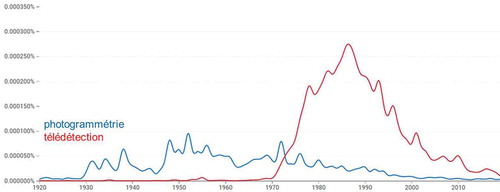
Figure 12. Occurrences of the Spanish terms fotogrametia, percepción remota and teledetección (1920–2019)
It can also be observed () that the use of the term remote sensing and its translations into other languages declined in the 1990s. Such a decline may occur when the designated object no longer exists, but this was far from being the case for remote sensing at that time, given the growing importance of space imagery in all fields. However, the word was probably out of fashion, as the fact that it had been used for four decades at the time could give the impression that it designated an old concept. Besides, the publications that had accompanied the early demonstrations of feasibility were no longer needed as the method had reached maturity. But the most likely explanation is that research and industry became specialized, and that disciplines that had become very broad, such as photogrammetry and remote sensing, diversified and survived into narrower disciplines with more specialized researchers, events and publications. This is probably what happened with the terms satellite, radar, laser, etc., which were less used after the 1990s (), and the innovations that followed were mostly refinements of these revolutionary concepts. In this general context, the boundaries between the old disciplines, such as photogrammetry and remote sensing, began to become blurred, and this is typically a situation that changes terminology, as shown below.
3.3. New paradigms around digital photogrammetry
In the 1970s, with the development of analytical photogrammetry, microcomputing enabled new accessory functionalities, notably for calculation and display, that had nothing to do with the basic principles of photogrammetry. This led to questions and concerns about the future of photogrammetry, whose boundaries had become blurred (Ackermann Citation1977), and about how this development could be accompanied in photogrammetrists’ capacity building (Hothmer Citation1976; Harley Citation1977). Toward the end of the century, geomatics created bridges between photogrammetry and other technologies. The possibility of all-digital mapping began to emerge (Franklin Citation1986) and photogrammetry could be integrated into a fully digital flow from image to map product and implemented on PCs (Gugan Citation1989) although the fundamental principles of photogrammetry had survived from analog to digital devices through analytical ones.
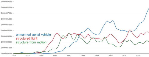
With these developments, the boundaries between different technical fields became uncertain. The link between concepts and terms, which had been stable for several decades and which had durably imposed the terms photogrammetry and remote sensing, was weakened and these two terms were often replaced by synonyms or split into several terms referring to extensions or parts of the old concepts. For instance, shows how the names of new concepts like structure from motion, structured light, unmanned aerial vehicle, in which photogrammetry is hidden, have developed in the 1980s while the use of the term photogrammetry was decreasing.
Figure 13. Occurrences of the terms unmanned aerial vehicle, structured light and structure from motion (1970–2019)
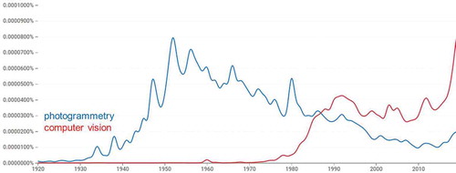
At the same time, i.e. after the 1980s, photogrammetry, which for a century had been almost exclusively applied to Earth topography and architectural buildings, began to focus on industrial objects or living bodies. This led to the development of “close range photogrammetry”, requiring less conventional imaging configurations that have become tolerable in the digital world. The photogrammetric community then met the computer vision community, which had tackled the same problem of close range 3D modeling by taking advantage of the calculation and display possibilities of recent computer equipments but with different hypotheses and algorithmic approaches (Granshaw and Fraser Citation2015). The meeting, or even the interpenetration of these two technological worlds, has undoubtedly contributed to weaken the use of the term photogrammetry () which had kept a strong cartographic connotation and whose use was, therefore, not natural for new users.
Figure 14. Occurrences of the terms photogrammetry and computer vision (1920–2019)
4. Discussion
This historical overview of the use of the terms photogrammetry and remote sensing has shown that the evolution of terminology is to some extent a tracer of the evolution of the scientific and technical context. The tool used in this article to visualize the evolution of terms is very powerful, especially since it offers the possibility of comparing several languages, but it has certain limitations that may call into question our interpretation. For instance, all books are indexed in the same way, regardless of their success. In addition, our analysis begins in the mid-19th century and early documents may not be available on the web or only through poor quality scans. They may also have incorrect metadata, such as dates. Another limitation is that British and American English give different results, although the whole English corpus was used in this study. Finally, at all times, uncertain spelling may have skewed the results.
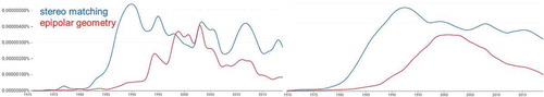
Note that Ngram Viewer proposes to adapt a smoothing parameter, which we have set to 0 in this article but which could allow us to smooth the search result. The interest of the smoothing is not only esthetic, it also takes into account the fact that the publication date actually characterizes a period of several years. Indeed, a book synthesizes ideas that may have arisen several years before its publication, and its dissemination to readers will take several years too. shows that a high smoothing factor can take into account this process of dissemination of ideas and highlight major trends. Thus, the terminology is a tracer of the evolution of techniques, and tools are available to analyze it, but this tracer is far from perfect.
Figure 15. Occurrences of the terms stereo matching and epipolar geometry (1970–2019) for two different smoothing factors: 0 (left) and 5 (right)
The decline of technical terms, or their dilution into a variety of non-standardized terms, may correspond to periods when research and industry spontaneously produce new concepts, like when the first attempts were made to use images for surveying, or more recently since the development of digital photography. However, the conditions under which the terms photogrammetry and remote sensing have stabilized illustrate the role of large associative and institutional structures. Thus, the International Society for Photogrammetry clearly contributed to stabilizing the term photogrammetry at the beginning of the 20th century despite the coexistence of several working languages. From the 1960s onwards, NASA and other space agencies were able to launch the first Earth observation missions thanks to a financial and technological power that gave them the legitimacy to influence the choice of remote sensing and related terms. In other fields where new concepts or objects are discovered or invented on a regular basis, they are usually named according to strict rules but this is also done under the control of official bodies or scientific societies. For example, hurricanes are given first names by meteorological administrations in the different oceans (e.g. NHC in Northern Atlantic), and for plant species the Linnaeus principle is applied according to rules of nomenclature agreed upon by the International Botanical Congress held every year, etc. This is necessary to make communication, translation and teaching more efficient and safe. It is also important for legal reasons. For example, the animal and plant species to be protected by law must be named unambiguously. Similarly, the legal texts governing georeferencing in different countries must be based on clear topographical concepts and therefore on explicit terms.
However, when a new concept affects the daily life of the general public, the stability of its name is much more uncertain under the influence of the web and social networks, which have often proven to be very powerful in making words appear or disappear. Moreover, even in the professional community, image acquisition and processing tools have become increasingly user-friendly, they are used carelessly and there is less temptation to name them. Research is sometimes published in the field of ecology without mentioning remote sensing, and in the field of cultural heritage documentation without mentioning photogrammetry. Implementation details (sensor, processing parameters, etc.) are indicated but there is no need to name those techniques that have become so familiar. Moreover, all this work is now included in the broad field of geoprocessing, where specific image acquisition and processing techniques have disappeared for being integrated with many other functionalities.
The use of photogrammetry and remote sensing has become implicit. This is not unlike prose in Le Bourgeois Gentilhomme. In this play by Molière, a vulgar bourgeois tries to become an aristocrat, and when his master of philosophy explains to him that he is speaking in prose, he answers “My goodness! For more than forty years, I have been speaking in prose without knowing anything about it”. Similarly, with the democratization of Earth observation imagery and related tools, one can now implement photogrammetry and remote sensing without knowing anything about them.
5. Conclusions
This article has shown that the evolution of the terminology in the fields of photogrammetry and remote sensing reflects fairly accurately the evolution of concepts, from the first inventions in the mid-19th century to their integration in a wide range of methods that have recently emerged around digital imaging and geospatial information. The evolution of the terminology described by the outputs of Google Ngram Viewer can be explained fairly well by taking into account the cultural and geopolitical context that may have influenced the evolution of the methods and their appropriation. The interest of such an analysis is that it allows us to recognize the concepts behind the terms and to observe that photogrammetry and remote sensing, whose subject matter has diversified with the development of digital solutions, remain very dynamic disciplines despite the decline of the classical terms that have always designated them.
Disclosure statement
No potential conflict of interest was reported by the author.
Data availability statement
The data that support the findings of this study are openly available through the Google Ngram Viewer which can by run online (https://books.google.com/ngrams).
Additional information
Notes on contributors
Laurent Polidori
Laurent Polidori is a senior scientist in remote sensing and geodetic sciences, presently appointed as the director of CESBIO (Centre of spatial studies of the biosphere, Toulouse, France). He was formerly professor at CNAM (France) and Director of ESGT (a faculty of geodetic sciences and land administration) and the associated research lab GeF. He received a PhD in remote sensing and geoscience from Paris University in 1991. His former positions were with Aerospatiale (now Thales Alenia Space, Cannes) and IRD (French Guiana). His research is on photogrammetry and remote sensing, mainly radar mapping techniques and their applications. He has been the president of the French Society for Photogrammetry and Remote Sensing (2008-2014). He is invited professor in UFPA (Belém, Brazil).
References
- Ackermann, F. 1977. “Some Thoughts on the Future of Photogrammetry.” The Photogrammetric Record 9 (50): 147–155. doi:10.1111/j.1477-9730.1977.tb00078.x.
- Aggarwal, C. C., and C. X. Zhai. 2012. Mining Text Data. ISBN 978-1-4614-3222-7. New York: Springer.
- Albertz, J. 2001. “Albrecht Meydenbauer – Pioneer of Photogrammetric Documentation of the Cultural Heritage.” Proceedings 18th International Symposium CIPA 2001, Potsdam, Germany, September 18-21, pp. 19–25.
- Albertz, J. 2007. “A Look Back: 140 Years of “Photogrammetry”: Some Remarks on the History of Photogrammetry.” Photogrammetric Engineering and Remote Sensing 73 (5): 504–506.
- Budin, G. 2001. “A Critical Evaluation of the State-of-the-art of Terminology Theory.” Terminology Science and Research: Journal of the International Institute for Terminology Research 12 (1–2): 7–23. IITF. Vienna, TermNet.
- Franklin, D. P. 1986. “Digital Mapping Fact or Fiction!” Defense Mapping Agency, Washington DC, presented at Auto Carto, London, UC, 14-19 Sept 86.
- Granshaw, S. I., and C. S. Fraser. 2015. “Editorial: Computer Vision and Photogrammetry: Interaction or Introspection?” The Photogrammetric Record 30 (149): 3–7. doi:10.1111/phor.12092.
- Grimm, A. 2007. “The Origin of the Term Photogrammetry.” In 51st Photogrammetric Week, edited by D. Fritsch, 53–60. Heidelberg: Wichmann Verlag.
- Gugan, D. J. 1989. “Future Trends in Photogrammetry.” Photogrammetric Record 13 (73): 79–84. doi:10.1111/j.1477-9730.1989.tb00648.x.
- Guibert, L. 1965. La Formation Du Vocabulaire De L’aviation (1861-1891). Paris: Larousse.
- Guibert, L. 1967. Le Vocabulaire De L’astronautique. Rouen: Publications de l’Université de Rouen.
- Harley, I. A. 1977. “Teaching in Photogrammetry.” The Photogrammetric Record 9 (49): 25–39. doi:10.1111/j.1477-9730.1977.tb00412.x.
- Hothmer, J. 1976. “Education for Users of Photogrammetry.” Photogrammetric Engineering and Remote Sensing 42 (6): 803–806.
- Konecny, G. 1985. “The International Society for Photogrammetry and Remote Sensing – 75 Years Old, or 75 Years Young.” Photogrammetric Engineering and Remote Sensing 7: 919–933.
- Laussedat, A. 1859. “Mémoire sur l’emploi de la photographie dans la levée des plans.” Compte Rendu de l’Académie des Sciences 49: 732–734.
- Pitch, H. 2011. “The Science of Terminology: History and Evolution.” Terminologija 18: 6–26.
- Polidori, L. ed. 2019. Aimé Laussedat (1819-1907) le précurseur de la photogrammétrie. Paris: Editions Publi-Topex.
- Polidori, L. 2020. “On Laussedat’s Contribution to the Emergence of Photogrammetry.” International Archives of the Photogrammetry, Remote Sensing and Spatial Information Sciences XLIII-B2-2020: 893–899. https://doi.org/10.5194/isprs-archives-XLIII-B2-2020-893-2020
- Ragey, L. 1952. “The Work of Laussedat and Education at the National School and Arts and Crafts.” Photogrammetric Engineering 18(1): 21–26.
- Vaughan, W. W., and D. L. Johnson. 1994. “Meteorological Satellite. The Very Early Years, Prior to Launch of TIROS-1.” Bulletin of the American Meteorological Society 75 (12): 2295–2302. doi:10.1175/1520-0477(1994)075<2295:MSVEYP>2.0.CO;2.