
ABSTRACT
The COVID-19 (coronavirus) disease has affected over 100 countries in a matter of weeks. The way humans live and work on planet Earth has changed profoundly over the last months. Many lives and livelihoods have been lost. Ways of working, shopping, and social interactions are all vastly different for most of us. We do not know when the current crisis will end, or how far we will “return” to the way things were before the pandemic. The world is experiencing one of the most transformative moments of the last 100 years. The social, economic, and political influences of the COVID-19 crisis have already been hugely momentous, we do not utterly understand it. Looking ahead, we have inevitably had to make important public health, economic, governance, and ecological decisions with less information than usual and to reverse recently adopted policies, which can lead to an era of disruptive transformations to sustainability. During these historic times, we must understand the hidden reality of the earth system and attempt to transform our needs so that we all have a sustained future on our planet.
1. Introduction: early development of human needs
Humankind has always been confronted with the question “Who I am?” and “What is the meaning of my existence?”. Before we tried to find adequate answers to these essential questions, we first tried to overcome the difficulties of our daily life and to solve the problems of our existence. At the beginning of the recorded history of humankind, the focus was on having enough food and water (for our existence) and to have a shelter (to protect ourselves from various natural events and enemies). These were the main human needs at that time. When we settled, we began to cultivate (food) and tried to find the most adequate place for settlement (shelter) to fulfill these human needs.
Early recordings of the history of mankind show that the life of the land depended mostly upon large rivers, sometimes two like the Tigris and the Euphrates in Mesopotamia/Middle East or the Yellow River (Huang He) and the Yangtze (Chang Jiang) in China. The land was harsh and made habitable only by extensive damming and irrigation works. But humans succeeded in both places.
In prehistoric times, advice and knowledge were passed from generation to generation in an oral tradition. The development of writing enabled knowledge to be stored and communicated across generations with much greater fidelity. Combined with the development of agriculture, which allowed for a surplus of food, it became possible for early civilizations to develop and spend more time devoted to tasks other than survival, such as the search for knowledge’s sake. Out of these practices grew, first, a highly developed mathematics that went far beyond the requirements of daily business, and then, some centuries later, descriptive astronomy.
People living in Mesopotamia (today Iraq) were called “Sumerians” (). These Mesopotamian people began to attempt to record some observations of the world with extremely thorough numerical data. A concrete instance of Pythagoras’ law was recorded as early as the 18th century BC (the Mesopotamian cuneiform tablet Plimpton 322 records several Pythagorean triplets), over a millennium before Pythagoras, but an abstract formulation of the Pythagorean theorem this was not (von Wolfram and Richard Citation2020).
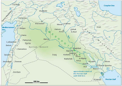
Figure 1. Map showing the extent of Mesopotamia
Astronomy is a science that lends itself to the recording and study of observations: the vigorous noting of the motions of the stars, planets, and the moon are found on thousands of clay tablets created by scribes. Even today, astronomical periods identified by Mesopotamian scientists are still widely used in Western calendars: the solar year, the lunar month, the seven-day week. Using these data, they developed arithmetical methods to compute the changing length of daylight in the year and to predict the appearances and disappearances of the Moon and planets, and eclipses of the Sun and Moon. Only a few astronomers’ names are known, such as that of Kidinnu, a Chaldean astronomer and mathematician who was contemporary with the Greek astronomers. Kiddinu’s value for the solar year is in use for today’s calendars.
This development has been observed in many places. As mentioned above the Yellow River (Huang He)) and the Yangtze (Chang Jiang) river in China, or Nile and Ganges valleys show similar developments.
As has already been noted, astronomy seems to have been the first science to emerge everywhere. Its intimate relation to religion gave it a ritual dimension that then stimulated the growth of mathematics. Chinese savants, for example, early devised a calendar and methods of plotting the positions of stellar constellations. Since changes in the heavens presaged important changes on the Earth (the Chinese considered the universe to be a vast organism in which all elements were connected), astronomy and also astrology were incorporated into the system of government from the very dawn of the Chinese state in the 2nd millennium BC.
2. The development of human needs in later centuries
Maslow, who is the father of behavioral psychology, started a classification system that reflected the universal needs of society as its base and then proceeded to more acquired emotions (Maslow Citation1943). Maslow’s hierarchy of needs is used to study how humans intrinsically partake in behavioral motivation. Maslow used the terms “physiological”, “safety”, “belonging and love”, “social needs” or “esteem”, and “self-actualization” to describe the pattern through which human motivations generally move. He defined them in a pyramid (Abraham Citation1973), see also .
Figure 2. Maslow’s hierarchy of needs, represented as a pyramid with the more basic needs at the bottom
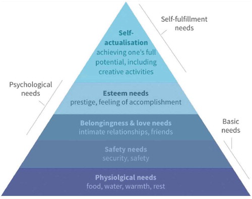
These basic needs were:
Physiological: hunger, thirst, bodily comforts, etc.
Safety/security: out of danger.
All the developments over the centuries show us that humankind was interested in fulfilling its daily needs as mentioned. If the needs could not be adequately fulfilled, we tried to explore new ways (routes) to secure them from alternative sources. All the developments going west to explore India but finding a new continent, or establishing a first link between Europe and Asia via the sea route, connecting the Atlantic and the Indian oceans and therefore, the West and the Orient, relied on the exploration of alternative routes to the Silk Road. It is the second stage of human needs based on security and safety. Although there have been several mistreatments to the newly explored area’s inhabitants, the main concept remains the same: worshipping and respecting mother nature. Although there are several attempts to define human needs Maslow’s theory is still valid (Su Citation2012).
However, this development did not remain steady. A wonderful example of deviations from the main line is the discrepancies between Native Americans and People who conquered America. It is reflected in Chief Seattle’s famous Speech (https://en.wikipedia.org/wiki/Chief_Seattle).
Furthermore, in the centuries following the Indian Chief Seattle speech, his advocacy was forgotten. Humankind has been overwhelmed with a strong interest in more power (tyrannize the majority, achieve more financial savings). The world has unfortunately experienced two World Wars, which caused several millions of deaths and a severe mistrust.
During these times geospatial technologies developed extremely well but their focus was the Mother Earth and exploring the potential of resources. However, as mentioned below, by developing technologies like remote sensing and geospatial information sciences, humankind learned that the basic needs are not the only essential needs; they realized that sustainability is furthermore a most important issue which should be considered.
3. The second part of the twentieth century
After all these terrible events, humankind tried to remember that a peaceful coexistence with all nations is inevitable and they formed some institutions (such as the United Nations or UNESCO). Still, there was no sign of realization in understanding that a sustained life on the earth can only be when you live in harmony with Nature. In case you interfere with actions outside of the system of Mother Earth, the Earth system responds to it in a very attentional way that remains persistent (Jodlbauer Citation1926).
Since the beginning of the Industrial Revolution in the mid-18th century, we have witnessed a shift from societies based on agriculture and handicrafts to societies based on large-scale industry, manufacturing, and the division of labor represented the beginning of a new era. This changed the way we live. The Industrial Revolution introduced several inventions and increased the overall amount of wealth. But it also resulted in crowded urban slums around factories in which millions toiled in miserable conditions. Those factories produced air and water pollution.
We are still working to understand and cope with the human and environmental effects of the Industrial Revolution in the 21st century. We do not have any understanding of how we interfere with the Earth system, but the system responds to us in a way (like climate change, sea-level rise, droughts, and food shortage) which we cannot foresee.
To solve all these problems, we must work: scientists, NGOs, citizens, in short, all actors leveraging policy drivers to a defined role with uniquely defined measures. The end goal of all actions should be a resilient society. Resilience means knowing how to cope despite setbacks, or barriers, or limited resources. Resilience is a measure of how much you want something and how much you are willing and able to overcome obstacles to get it. It has to do with your emotional strength. A good example of this is the Conversion of Cropland to Forestland Program which has been implemented in some Chinese Provinces (Ma et al. Citation2019).
Emotional strength is not a fine definition if you do not give early setback goals. This was done in “The Millennium Development Goals” (MDGs) which were defined, agreed, and signed in September 2000, by leaders of 189 countries gathered at the United Nations headquarters as the historic Millennium Declaration, in which they committed to achieving a set of eight measurable goals that range from halving extreme poverty and hunger to promoting gender equality and reducing child mortality, by the target date of 2015 (https://www.un.org/millenniumgoals/).
The MDGs were revolutionary in providing a common language to reach a global agreement. The eight goals were realistic and easy to communicate, with a clear measurement/monitoring mechanism.
Substantial progress has been made regarding the MDGs. The world has already realized the first MDG of halving the extreme poverty rate by 2015. However, the achievements have been uneven. The MDGs were set to expire in 2015 but the discussion of a post-2015 agenda continues. The focus is now on building a sustainable world where environmental sustainability, social inclusion, and economic development are equally valued.
The Rio+20 conference (the United Nations Conference on Sustainable Development in Rio de Janeiro, June 2012), galvanized a process to develop a new set of Sustainable Development Goals (SDGs) which will carry on the momentum generated by the MDGs and fit into a global development framework beyond 2015 (https://www.un.org/sustainabledevelopment/) .
4. The twenty-first century and COVID-19
On 30 January 2020, the WHO declared the outbreak a Public Health Emergency of International Concern (PHEIC). Response to the COVID-19 pandemic has been a major disruptive force on a global scale and geospatial data and collaboration between organizations and governments has been a major factor in this, as we discuss in this section.
There is clearly a problem about how to combat a disease that has not been seen before and which requires scientific advice to the decision-makers. Knowledge-based advice to governments, preparedness, public awareness, and timely actions are an urgent requirement in order to cope with crises and disasters. Fruitful cooperation between scientists, policymakers, and society at all stages of disaster risk management would contribute to resilience and sustainability and is vitally important during all crises/disasters. (https://council.science/current/blog/placing-scientific-knowledge-preparedness-and-public-awareness-at-the-core-of-disaster-risk-policy/)Geospatial technology is important in providing visualizations of the spread of the disease. Print media and television make use of this but tend to use maps from third-party providers such as Johns Hopkins University (https://coronavirus.jhu.edu/map.html) and ESRI (https://coronavirus-resources.esri.com).
Earth observations, geospatial data, and derived information play insightful roles in monitoring targets, planning, tracking progress, and helping nations and stakeholders make informed decisions, plans, and ongoing adjustments that will contribute toward achieving the SDGs (Shao et al. Citation2020). Combined with demographic and statistical data, these sources enable nations to analyze and model conditions, create maps and other visualizations, evaluate impacts across sectors and regions, monitor change over time in a consistent and standardized manner, and improve accountability (https://www.earthobservations.org/geo_sdgs.php#:~:text=Earth%20observations%2C%20geospatial%20data%2C%20and,contribute%20toward%20achieving%20the%20SDGs). A report in the August ISPRS eBulletin (Li and Shi Citation2020) covered the work done in China by Professor Deren Li and his team at Wuhan University. They used space-based remote sensing and geospatial technologies to fight the epidemic prevention battle in Wuhan, for example, they assessed the impact of the construction of Huoshenshan and Leishenshan hospitals on the surrounding environment.
The novel Coronavirus Disease 2019 (COVID-19) has caused severe acute respiratory syndrome globally and created a health crisis for people all over the world. Social distancing has proved to be an effective non-pharmaceutical measure to slow down the spread of COVID-19. There are researchers using Unmanned Aerial Vehicles (UAVs) and surveillance videos as flexible mobile platforms to detect small objects, which is helpful for social distance monitoring (Zhang et al. Citation2020; (Shao et al. Citation2019a, Shao, Cai, and Wang Citation2017). And if the resolution of the image is not high enough, the researchers also use super-resolution processing to improve the resolution and realize the detection of small targets such as the persons, ships, and cars (Shao et al. Citation2019b).
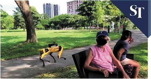
Restrictions on the way in which we behave have led to apps being developed to assist organizations plan their space to ensure social distancing and also for individuals to keep their distance. It is the first trial of a new initiative to help manage and enforce social distancing in the Singapore parks, gardens, and nature reserves, all managed by the National Parks Board. Singapore has taken the monitoring and enforcement of social distancing to a whole new level, opting to deploy a robot dog, backed by a fleet of drones, to make sure citizens keep their hands to themselves to combat the coronavirus. Beginning on Friday, May 8, the robot dog, creatively dubbed “Spot,” started to monitor the Bishan-Ang Mo Kio Park in the city-state (see ).
Figure 3. The robot dog, backed by a fleet of drones, to make sure citizens keep their social distances
Simulation and modeling have been very useful with software such as Bentley’s Legion, to simulate and analyze the foot traffic, for example, and to plan for social distancing and optimize the use of space and mitigate risk.
An important impact of the coronavirus is the transfer of the disease from human to human, contact tracing is a measure to keep this impact under control. Many societies and governments are developing different technologies to trace contacts of an infected person to others. Contact tracing is defined by the WHO as “the process of identifying, assessing, and managing people who have been exposed to a disease to prevent onward transmission … Contact tracing for COVID-19 requires identifying people who may have been exposed to SARS-CoV-2, the virus that causes COVID-19, and following them daily for 14 days. The goal is to stop transmission of the virus by reducing the number of people who are circulating with the virus” (https://www.who.int/news-room/q-a-detail/coronavirus-disease-covid-19-contact-tracing).
To use this tracing mechanism effectively and automatically, some governments and companies offered digital contact tracing using specific programs downloadable to mobile phones. Especially in South Korea and China, it has been an effective way to keep infections down. In South Korea, this incorporates patient interviews as well as the use of medical records, cell phone GPS records, credit card transaction records, and closed-circuit television. It was also reported that China used phones to record travel history and CCTV for facial recognition using AI and machine learning. Li and Shi (Citation2020) have advised the Chinese government on how to use full big data from mobile phones, to identify people who should be isolated, the key persons to trace, and those who were risk-free. China also used a central database and collects and stores data. But these successful approaches rely on a level of trust in authority and giving up privacy, which may not be acceptable in some countries such as the United States.
Combining different types of information could be essential for evaluating where resources should be allocated. An example of this is Trimble Connect which is an open collaboration platform for design and construction that connects project stakeholders with the data they need to inform decisions and improve team efficiency. Trimble reports that the number of invitations to collaborate on projects increased by 58% in April over the previous month.
In the United Kingdom, Ordnance Survey (OS) has been supporting a wide range of public bodies over the last month as COVID-19 has developed (https://www.ordnancesurvey.co.uk/about/covid-19). Since February, use of Ordnance Survey’s digital mapping and outdoor adventure planning tool and app OS Maps has increased by 78% despite the nation entering lockdown. Views of the OS Maps’ and the recently added National Cycle Layer Network has increased since February by 98% as people are discovering cycling routes near where they live; www.getoutside.co.uk/covid is a one-stop shop for up-to-date information on what to do and where to go safely outdoors across England, Scotland, Wales and Northern Ireland.
Other applications of geospatial data include a queue management and response management, identifying supermarkets with large car parks to help with screening and/or testing locations, and identifying care homes and pharmacists. They are also supporting route planning and measurement of pavement widths and any issues with social distancing in Britain’s towns and cities. Li and Shi (Citation2020) have reported that geospatial information technology was deployed in, for example, traffic guidance management, transportation of prevention and control materials, robots for disinfection, food and medical equipment deliveries to the hospitals, as well as the logistical management of electric bikes provided for medical personnel to get to and from work.
The Turkish Government Ministry of Health prepared a program on mobile devices to serve during controlled social life conditions, called HES (Hayat Eve Sığar – Life Fits into Home). The code helps you safely share your COVID-19 risk status with institutions and individuals for activities like transportation or visits. Shared HES codes can be checked through the app or services provided to institutions. An important item here is to be sure that the code is handled as safely as announced. Many organizations and individuals see it as a threat to privacy.
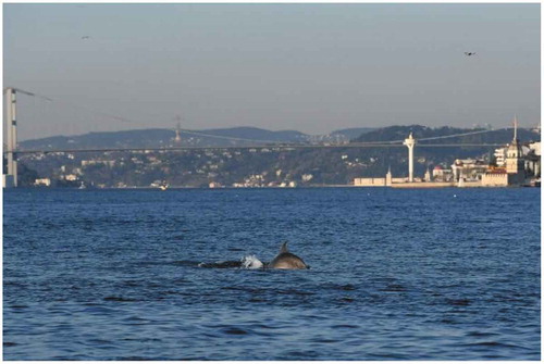
As some countries start to ease lockdown measures after months of restrictions, Istanbul’s dolphins have made the most of quiet waterways in the Bosporus. Usually, the long-nosed mammals prefer to avoid the busy Bosporus Strait that divides Istanbul between Europe and Asia. Like Mumbai and Sardinia, Istanbul has also seen a sharp decline in boat and human movement which has led to the dolphin sightings. However, there are usually some sightings throughout the year.
The picture of indicates that taking care of mother nature’s rules and living zones could be a wakeup call for humanity. A peaceful co-existence is vital for all humans and species living on this planet. We have unfortunately forgotten this during the last decades. Uncontrolled development in the growth of the human population in city areas is a severe treatment for humanity. The coexistence of humans and mother nature has been realized by many scientists and a good example is that the architects have realized this several years before.
Figure 4. Dolphins in the port of Istanbul as the ship traffic slows down during the continuing days of movement restrictions
5. Conclusions
Urbanization is one of the most impactful human activities across the world today, affecting the quality of urban life and its sustainable development (Shao et al. Citation2020). Wikipedia defines the concept of the “Meaning of Life” as follows: “A meaningful life is a construct having to do with the purpose, significance, fulfillment, and satisfaction of life” (https://council.science/about-us). And here, the human needs come into play, which we have touched on at the beginning, more detailed the upper part of the triangle, which are the self-fulfillment needs (self-actualization: achieving one’s full potential, including creative activities). So, in that case, self-actualization should be understood in a boarder sense and its meaning must be referred to our society.
We must understand the potential of society and direct it to the fulfillment of global activity to rely on a uniquely defined base and goal with targets and indicators. This can only be achieved by relying on well-defined societal and regional data (area) derived by geoInformatics (GIS, remote sensing and census data). Especially, earth observation plays an important role (Shao et al. Citation2019c; Hollwich, Dieckhaus, and Meiners Citation1926). Here, crosschecks are important as nowadays the information derived from data cannot be hidden as there are many technological innovations to prove the relationships. So, the human needs are to be fulfilled in such a way that its fulfillment is not anymore a single need, IT IS A SOCIETAL NEED or better IT IS A GLOBAL NEED. At this stage, the geoinformatics sciences and technologies should go out of their conventional usage areas and explore new alliances. Here, not only the neighboring disciplines also other disciplines should be a partner by exploring new application fields. Human behavioral disciplines (social sciences) are a new area of partners. Here, the ISPRS Working Group WGV/3 Promotion of Regional Collaboration in Citizen Science and Geospatial Technology (Hollwich, Dieckhaus, and Meiners Citation1926) is a new attempt. However, this should be complemented by different projects and working groups. One of the great geniuses of our times was Stephan Hawkins, and he said “While physics and mathematics may tell us how the universe began, they are not much use in predicting human behavior because there are far too many equations to solve.” Geospatial technologies would not dare to solve these equations to predict the human behavior, but it can help to understand the human influence for long sustainability “to advance science as a global public good” (Greg and Abbas Citation2017) .
The authors sincerely hope that to the humans on this planet, the meaning of life will be understood just as Chief Seattle told us several centuries before: that we are not alone on this planet and we all are very dependent on our and other’s actions. There is no situation on earth where a human being can exist in a sustainable way without performing a kind of productive labor in a way that is in harmony with the “other’s needs”. The other is not only humans: It consists of every creature on this planet (and universe). During these COVID-influenced days, we have hopefully re-found that the Earth (and Universe) systems consist of several undetected mini systems, encapsulated in each other in harmony, and in a stable way. If we try to interact with this “System of Systems” and bring the equilibrium out of its stable condition, it reacts upon us and reminds us in quite different ways.
A good example of this approach is shown by the recent publication which discusses the multidimensional impacts of COVID-19, helps visualize the COVID-19 pandemic beyond an acute health crisis, and presents the emerging debates about the economy and environment amidst the pandemic.
Back to Basics is defined as “return to basic instruction; start the learning process over again “. During the last century, “Back to Basics” in science was used without a good knowledge of basic sciences so that one cannot achieve advances in other scientific areas. Now we are at the turning point of our existence and hopefully this turning to basics will be understood by all societies.
Disclosure statement
No potential conflict of interest was reported by the author(s).
Data available statement
There are no data related to this work.
Additional information
Notes on contributors
Orhan Altan
Orhan Altan is an emeritus professor at the Istanbul Technical University. He studied at the Faculty of Civil Engineering at Istanbul Technical University and graduation with Dipl.- Ing. in Civil Engineering, he was between 1972-1973 researcher at ETH-Zurich Institute of Geodesy and Photogrammetry for PhD study … He spent 1977-1979 6 months spent on research at the Institute of Applications of Geodesy to Civil Engineering at the Stuttgart University, sponsored by TÜBITAK, followed by a period of one and half years sponsored by the Alexander von Humboldt Foundation. He worked between 1990-2019 as “Guest Professor” in Stuttgart, Berlin, Munich Technical Universities (Germany), ETH-Zurich (Switzerland) and Wuhan University (China).
He is Corresponding member of the German Geodetic Commission at the Bavarian Academy of Sciences and cochair of the Advisory Board for Geodesy. Member of the International Astronautical Academy. Published more than 200 scientific papers in scientific journals and conferences, and editor or co-editor of more than 20 international books.
He was 2000–2004 ISPRS Congress Director/Organizer of the 2004 Congress in Istanbul, 2004–2008 Secretary General of ISPRS, 2008–2012 President of ISPRS, 2012–2016 1st Vice President of ISPRS, 2016 – Honorary Member of ISPRS; 2011–2018 he was Member of the Executive Board of the International Council for Science and 2018 – World Bank Consultant on the improving resilience and resilience impact of national land and geospatial systems.
Ian Dowman
Ian Dowman is an Emeritus Professor of Photogrammetry and Remote Sensing at University College London (UCL), he has a PhD from the University of London and is a Fellow of the Royal Institution of Chartered Surveyors. He has worked as a photogrammetrist and remote sensor for 40 years at UCL in the field of applying photogrammetric techniques to a wide range of image sensors for surface and feature extraction.
Ian has been active in ISPRS and was Secretary General from 2000-2004 and President from 2004-2008. In these capacities, he has worked with many international organizations, including the United Nations, The Group on Earth Observations (GEO), The Committee on Earth Observation Satellites (CEOS) and the International Council of Science (ICSU), as well as many national survey mapping agencies and national photogrammetry societies. He have been particularly active in Africa and has organized workshops on capacity building and applying Earth observations data to practical problems.
Ian has published over 140 papers in refereed journals and conference proceedings and has coauthored a text book on high-resolution optical satellite imagery. He is currently editor of Geomatics World.
References
- Abraham, H. M. 1973. The Farther Reaches of Human Nature. London: Penguin Books.
- Greg, S., and R. Abbas. 2017. “Sustainable Development and Geospatial Information: A Strategic Framework for Integrating a Global Policy Agenda into National Geospatial Capabilities.” Geo-spatial Information Science 20 (2): 59–76. doi:10.1080/10095020.2017.1325594.
- Jodlbauer, A. 1926. “Die Physiologischen Wirkungen Des Lichtes.” In Wärme- Und Wasserhaushalt Umweltfaktoren · Schlaf · Altern Und Sterben · Konstitution Und Vererbung: Correlationen Iii, edited by L. Adler, J. Bauer, W. Caspari, U. Ebbecke, C. V. Economo, H. Freund, C. Herbst, et al., 305–342. Berlin, Heidelberg: Springer Berlin Heidelberg.
- Hollwich, F., B. Dieckhaus, and C. O. Meiners. 1926. “Die physiologische Wirkung des Lichtes für den Menschen, Lichttechnik 27.” JahrgangNr10/1975. S, 388–394.
- Li, D., and L. Shi 2020. “Fighting the Pandemic in Multiple Dimensions.” ISPRS eBulletin, August. Accessed 14 December 2020. https://www.isprs.org/news/newsletter/2020-03/index.html
- Ma, O. Z., G. Wang, G. Wang, L. Wang, and L. John. 2019. “Technical Efficiency Analysis of the Conversion of Cropland to Forestland Program in Jiangxi, Shaanxi, and Sichuan.” The International Journal of Sustainable Development Innes, and World Ecology 9: 1–12.
- Maslow, A. H. 1943. “A Theory of Human Motivation.” Psychological Review 50 (4): 370–396. doi:10.1037/h0054346–viapsychclassics.yorku.ca.
- Shao, Z., H. Fu, D. Li, O. Altan, and T. Cheng. 2019c. “Remote Sensing Monitoring of Multi-scale Watersheds Impermeability for Urban Hydrological Evaluation.” Remote Sensing of Environment 232: 111338. doi:10.1016/j.rse.2019.111338.
- Shao, Z., J. Cai, and Z. Wang. 2017. “Analytical Processing Method of Big Surveillance Video Data Based on Smart Monitoring Cameras.” Journal of Electronics & Information Technology 39(5): 1116–1122. doi:10.11999/JEIT160712.
- Shao, Z., L. Wang, Z. Wang, W. Du, and W. Wenjing. 2019a. “Saliency-aware Convolution Neural Network for Ship Detection in Surveillance Video.” IEEE Transactions on Circuits and Systems for Video Technology. doi:10.1109/TCSVT.2019.2897980.
- Shao, Z., L. Wang, Z. Wang, and Z. Deng. 2019c. “Remote Sensing Image Super-Resolution Using Sparse Representation and Coupled Sparse Autoencoder.” IEEE Journal of Selected Topics in Applied Earth Observations and Remote Sensing 12: 2663–2674. doi:10.1109/JSTARS.2019.2925456.
- Shao, Z., N. S. Sumari, A. Portnov, F. Ujoh, W. Musakwa, and P. J. Mandela. 2020. “Urban Sprawl and Its Impact on Sustainable Urban Development: A Combination of Remote Sensing and Social Media Data.” Geo-spatial Information Science 1–15. doi:10.1080/10095020.2020.1787800.
- Su, M. D. P. 2012. “Core Values – The Entrance to Human Satisfaction and Commitment.” Journal of Total Quality Management & Business Excellence 23 (2): 125–140. doi:10.1080/14783363.2012.655067.
- von Wolfram, T. S., and N. F. Richard “History of Mesopotamia”. Accessed 24 December 2020. https://www.britannica.com/place/Mesopotamia-historical-region-Asia
- Zhang, R., Z. Shao, X. Huang, Wang, and D. Li. 2020. “Object Detection in UAV Images via Global Density Fused Convolutional Network.” Remote Sens 12: 3140. doi:10.3390/rs12193140.