
 ?Mathematical formulae have been encoded as MathML and are displayed in this HTML version using MathJax in order to improve their display. Uncheck the box to turn MathJax off. This feature requires Javascript. Click on a formula to zoom.
ABSTRACT
It is well agreed that geologic risk occurs during hydrocarbon exploration because diverse uncertainties accompany the entire hydrocarbon system parameters such as the source rock, reservoir rock, trap and seal rock. In order to overcome such attributes with uncertainties, a number of soft computing methods are used. Information granules could be provided by the Rough Fuzzy Set Granulation (RFSG) with a thorough quality evaluation. This is capable of attribute reduction that has been claimed to be essential in investigating the hydrocarbon systems. This paper is an endeavor to recommend a Geospatial Information System (GIS)-based model with the aim of categorizing the hydrocarbon structures map consistent with the uncertainty range concepts of geologic risk in the rough fuzzy sets and granular computing. The model used the RFSG for the attribute reduction by a Decision Logic language (DL-language). The RFSG was employed in order to classify hydrocarbon structures according to geological risk and extract the fuzzy rules with a predefined range of uncertainty. In order to assess the precisions of the fuzzy decisions on the hydrocarbon structure classification, the fuzzy entropy and fuzzy cross-entropy are applied. The proposed RFSG model applied for 62 structures as the training data, average fuzzy entropy has been calculated as 0.85, whereas the average fuzzy cross-entropy has been calculated 0.18. As it can be discerned, just seven structures had cross-entropies greater than 0.1, while three structures were larger than 0.3. It is implied that the precision of the proposed model is about 89%. The results yielded two reductions for the condition attributes and 11 fuzzy rules being filtered by the granular computing values.
1. Introduction
In general, the life cycle to investigate the hydrocarbon systems in a sedimentary basin would cost a huge amount of investment and take a lengthy time. Furthermore, throughout its life cycle, because of being a multi-criteria decision-making procedure, it encompasses numerous risks. They include technical, economic, environmental, geological, portfolio and financial risks. The current research attempts to take into account the geological risk meaning the risk of the existence of a producible hydrocarbon accumulation. The professionals dealing with hydrocarbon exploration processes are undeniably expected to be aware of the magnitude of the geological risks in each geologic structure in a sedimentary basin. Numerous petroleum systems exist and every system possesses various attributes; for this reason, to obtain an efficacious exploration, it is necessary to conduct more accurate investigations.
In the process of hydrocarbon exploration, geological risk occurs due to the concerned experts’ unsatisfactory knowledge. In order to realize and control imperfect knowledge, numerous classical methods could be adopted. According to Malvic (Citation2017), these methods had been categorized into stochastic and deterministic approaches. The geological deterministic models are often numerical such as calculation of Probability of Success (POS; e.g. Malvic, Novak, and Zelenika (Citation2015), which this paper borrowed this concept as the core of its risk assessment process. As Rose (Citation2000) described, the geologic risk is evaluated by taking into consideration the probability that the subsequent four independent hydrocarbon system factors as EquationEquation (1)(1)
(1) explained:
where is the presence of a mature source rock,
is the presence of the reservoir rock,
is the presence of a trap and
is for the Play dynamics.
A conceptual model of uncertainty in spatial data which was proposed by Klir and Yuan (Citation1995) distinguishes between error embedded in data and vagueness which is encapsulated in them. The main focus of this research is to handle uncertainties in hydrocarbon system parameters which exist because of vagueness and must be modeled by soft computing theories such as rough sets and fuzzy sets not classical probability theories.
Vagueness arises in several complex issues of engineering, science and many other fields such as Heštera (Citation2020) and Siahuei et al. (Citation2021). These issues cannot be resolved using crisp mathematical methods in which defines the values of set members either 0 or 1. Many well-known theories, including probability theory, Fuzzy Set Theory (FST), Intuitionistic Fuzzy Set Theory (IFST), Vague Set Theory (VST), Interval Mathematics Theory (IMT) and Rough Set Theory (RST) have been established by Akram and Zafar (Citation2018) to explain uncertainty.
As Dubois and Prade (Citation1990) mentioned, we have discovered two types of widely implemented combined methodologies in uncertainty handling related to classification domains including fuzzy rough sets and rough fuzzy sets. Rough sets, as a tool for granular computing (Anh, Vo, and Pedrycz Citation2017; Hu, Xie, and Yu Citation2007), offer a unique induction structure in artificial intelligence (Wang and Tao Citation2003). Using this methodology, we granulate the universe of discourse into a group of granules to describe the objects and apply these concepts to determine random subsets of the universe. Feature evaluating, variable selection, attribute reduction (Hu, Xie, and Yu Citation2007; Qian, Liang, and Wei Citation2013), rule extraction (Leung et al. Citation2008) and uncertainty reasoning are the main developments encountered in rough sets theory (Yang and John Citation2008). Of these, the fuzzy set theory has been developed by Zadeh (Citation1965), which is referred to as a very efficacious method in many applications (Ashraf, Akram, and Sarwar Citation2014). Discriminating distinctive elements is really daunting once an issue encompasses incomplete, uncertain or vague information and then we are obliged to take into account the granules. It is the information processing science at different levels of granularity (e.g. Zadeh Citation1965; Pawlak Citation1982; Hobbs Citation1985; Zadeh Citation1997; Nguyen, Skowron, and Stepaniuk Citation2001; Miao and Fan Citation2002; Bargiela and Pedrycz Citation2003; Keet Citation2008 and Yao Citation2008a). By altering the equivalence relation, different types of rough set models were obtained (Wu, Mi, and Zhang Citation2003).
The current study has adopted granulation as a classification task to scrutinize the geological risks and opportunities in hydrocarbon exploration. The knowledge from either supervised or unsupervised data would be inextricably associated with uncertainty (Nguyen, Skowron, and Stepaniuk Citation2001). Therefore, such uncertainty along with the ones intrinsic to the data has been taken into account throughout the process. In line with this, it is well established that for the classification processes, granular computing would be good enough to deal with the uncertainty (Leung et al. Citation2008). Rough Fuzzy Set Granulation (RFSG) has been long considered as a successful method in solving the mentioned issue. It is of note that the RFSG, as an efficient approach, could be applied to elucidate and examine how decisions are made on classifying the hydrocarbon structures employing the qualified rules uncertainty exists.
The current research endeavors to introduce a Geospatial Information System (GIS)-assisted framework on the RFSG to examine the hydrocarbon system parameters of the hydrocarbon fields for envisaging the geologic risk associated with each structure with its relevant uncertainty. The recommended framework in this research can execute the spatial rule extraction from the spatial data with uncertainty in a GIS based RFSG process. According to the findings of a research elaborating on the hydrocarbon structures of Fars province of Zagros sedimentary basin in Iran, the latent knowledge is presented to choose the critical hydrocarbon system notion. It is an affiliated notion that embraces all of the various elements and processes of hydrocarbon system, including: the main elements (source, reservoir, seal and trap) and processes (trap formation, retention and exploration). Source rock refers to tiny-meshed sediment with sufficient amount of organic ingredients, which is capable of generating movable hydrocarbons. A reservoir rock is an underground rock that has proper porosity and permeability to permit the occurrence of hydrocarbon accumulation. Seal rock points to an impermeable rock all around the reservoir rock to maintain the hydrocarbon. Closure is the maximum distance between summit of trap and lowest level of it. Trap relates to accumulation process of hydrocarbon where retention is about the maintenance circumstances of hydrocarbon in an optimum mood. The extraction elements clarify the accessibility to hydrocarbon from earth to subsurface depth (Rose Citation2000). This provides the GIS-assisted strategies to be originated to classify the structures in line with the geologic risk for drilling. The paramount point here is that this risk would not be a crisp value and is a fuzzy range having lower and upper approximation borders because there are many uncertainties in hydrocarbon system parameters.
Indeed, a plethora of research has been conducted so far which resembles that of ours. For instance, the GIS capabilities were explained by Bin Mohammed, Javed, and Alshayef (Citation2017) with the intention of appraising the spatial multi-criteria approaches for hydrocarbon exploration which lend their basis to the fuzzy logic. Moreover, the offshore/subsea pipeline routing constraint was studied by Balogun et al. (Citation2017). They employed a hybrid decision system where a GIS is integrated with the fuzzy logic approximate reasoning models with the aim of obtaining an optimum performance. Likewise, an approach was introduced by Liu et al. (Citation2007) for oil and gas potential predictions in the seismic reservoirs working on the basis of the rough set algorithm. In another survey undertaken by Zhou, Yu, and Gu (Citation2017), the fuzzy logic and a GIS were employed with the purpose of fusing the geological and geophysical analyses when plotting the gas potential of a field in Kazakhstan carboniferous system that functioned on the basis of the assumed gas accumulation model. An approach was utilized by Han et al. (Citation2014) which worked based on the analysis of the rough set theory by the Support Vector Machine (SVM) method. The objective was to boost the ability of identifying the oil zones process. Furthermore, in order to help decision-makers to utilize a model meant for hydrocarbon exploration in Zagros sedimentary basin in Seraj and Delavar (Citation2018a, Citation2018b) integrated the soft computing, the GIS and multi-criteria decision analysis. The mentioned expedient experimentations have been taken into account by this research as paramount guiding principles, yet, it offers several considerations that are explained through the subsequent sections.
This research has several contributions. First of all, entire hydrocarbon parameters are involved together in calculating geologic risk for each structure instead of surveying parameters separately. Second, the proposed model applied different soft computing methods as fuzzy sets, rough sets and granular computing in a unique framework to take advantage of all the exclusive capabilities of each of these methods so that a hydrocarbon structure in a sedimentary basin may be a member of both the lower approximation and upper approximation of the geologic chance concepts to some degree. The last contribution is related to the ability of model in extraction of fuzzy rules with a certain degree of confidence for the hydrocarbon system to investigate the status of each structure.
2. Rough fuzzy set granulation
In order to elaborate on the calculus of human thoughts problem, many tools have been devised by the mathematicians so far. Regrettably, the devised tools in crisp mathematics, especially the ones in the classical mathematical logic have failed to assist recognizing the natural language which is utilized by the human concept with the intention of uttering judgments and reasoning about them as a perception which could help devices really intelligent systems. A cause might be the one that the mankind can effectively resolve numerous real-life complications while being capable of uttering thoughts via equivocal, uncertain and inaccurate perceptions and then reasoning about them. In order to go beyond computation with numbers to computation with words, and additionally to go beyond manipulations of measurements toward manipulations of perceptions, it was recommended by Zadeh (Citation1965) that it is better to base the thoughts calculus via the fuzzy logic. In line with this, “information granule” was recommended by (Zadeh Citation1965, Citation1979, Citation1999) which refer to a cluster of diverse objects which are combined based on indistinguishability, similarity, or functionality. The granular computing method categorizes the information into subsets or granules of information (Yao Citation2002; Yao Citation2008a; Lin Citation2003). Having yielded an information table concerning the problem, the granules are created by the granular computing by taking into account the resemblance of the attribute values of the objects. Later on, it concentrates on introduction of the classification rules.
EquationEquation (2)(2)
(2) provides the definition of an information table: (Pawlak Citation1991; Yao and Zhong Citation1999)
where U is a finite non-empty set of objects, AT is for a finite non-empty condition attribute set that comprises mc elements, D is a nonempty finite decision attribute set that encompasses md elements (m = mc + md) and AT∩D is empty. In rough sets, we have some additional information related to the elements. Elements that have same information are kept in one equivalence class, and with the help of these equivalence classes, we take lower and upper approximations of the set which leads to uncertainty (Zafar and Akram Citation2018). According to the rough sets and the fuzzy sets, the rough fuzzy set theory was introduced by Dubois and Prade (Citation1990) in dealing with Fuzzy Decision Information System (FDIS). In the rough fuzzy set theory, two operators are named the upper approximation and lower approximation,
are designed to roughly signify the fuzzy concept F.
and
which are two fuzzy sets on U with membership functions defined by EquationEquations (3)
(3)
(3) and (Equation4
(4)
(4) ). For ∀ x ∊ U,
When using the RFSG, two principal inspirations of the attribute reduction exists which are expulsion of the redundant attributes and enhancement of decision rules. The positive region is a vital conception in the attribute reduction in the RFSG. Taking into account sets C, D ⊆ A, and X ⊆ U, C and D would be the equivalence relations over U. The C-positive region of D characterizes the set of objects being appropriately categorized into D-elementary sets created by IND(D) by making use of the knowledge from C. IND(D) implies indiscernibility which is a property for certain specific attributes in an information table. It is an equivalence relation defined on U. In particular for and
, they are D-indiscernible with respect to D, which can be defined as follows (Zadeh Citation1979)
The C-positive region of D is defined as (Chen et al. Citation2015):
Moreover, an attribute is D-indispensable in C if
# POSC -(q) (D); otherwise, q is D-dispensable in C. Subset R of C is named the D-reduction of C if and only if R is the D-indispensable subset of C such that
. No superfluous attribute is allowed to be present in the reduction. No attribute could be eliminated from R without altering the equivalence classes. To put it simply, a reduction would be an essential constituent of the knowledge that is capable of capturing the entire basic concepts which scrutinized utilizing the indispensable attributes. In line with this, five kinds of reduction were presented by Zadeh (Citation1999) to be employed for the rule extraction in the RFSG. These could be induced on the basis of the discernibility matrix proposed by Yao (Citation2002). Consistent with what Yao (Citation2008a) claimed, a reduction type defined below was implemented in the current research because it was able to maintain the decision type as well as its precision; it is of note that the other four reductions fail to do so (Hu, Xie, and Yu Citation2007). Let
be FIDS, and A ⊆ AT. For
,
can be defined by using EquationEquation (7)
(7)
(7) :
Let be FIDS. An attribute subset A is known as an x_E consistent set of FI, if ⊆ EA(x) = EAT(x) for
. If AT is an x_E consistent set of FI, and no proper subset of A is also an x_E ⊆ consistent set, then A is referred to as an x_E reduction of F. By EquationEquation (7)
(7)
(7) , the decision having the maximum lower approximation membership value and the membership value of the objects under the decision are unaffected as well.
The decision rules in the RFSG which entail certain and possible rules could be induced from the concept of lower and upper approximation. By the time a reduction is acquired, the fuzzy decision rules could be effortlessly created by overlaying the reduction on the original decision table. Consistent with Han et al. (Citation2014), a decision rule in the FDIS is the expression Ф→Ψ, implying that if Ф then Ψ, where Ф and Ψ are the antecedent and consequent of the rule, respectively. Ф is a crisp set on U and Ψ is a fuzzy membership value. Specific indexes, namely, the generality and absolute support explained by EquationEquation (8)(8)
(8) and (Equation9
(9)
(9) ) are employed to authenticate the quality of the derived rules using the RFSG.
It is of note that the generality assesses the rule applicability, representing the extent of the objects or the relative number of the objects, to which the rule could be implemented. The generality has been defined by Yao (Citation2008b) as follows:
In granular computing, G stands for the support of the rule. The correctness of the rule is also assessed by the absolute support, defined by Yao (Citation2008b) as follows:
In granular computing, the absolute support implies the confidence or accuracy of the rule which could be considered as the conditional probability of a randomly selected element satisfying on the condition that the element satisfies Ф. In set-theoretic terms, this is known as the extent to which m (Ф) is contained within m (Ψ) (Yao Citation2008b).
3. Methods
This research has three main objectives:
A hydrocarbon structure in a sedimentary basin may be a member of both the lower and upper approximations of the geologic chance concepts to some degree which are uncertain concepts about spatial boundary of a structure. So the first goal is to calculate two optimistic and pessimistic values for each hydrocarbon structure. Based on these values, classification of structures will be possible in a specified range of uncertainty.
Decision making attributes reduce in a sedimentary basin during hydrocarbon system determination by applying attribute reduction procedure.
Fixed fuzzy rules are extracted from the information table which is related to hydrocarbon system. These rules are independent from structures and can be used for all over the sedimentary basin. They may be applied as a part of Spatial Decision Support Systems (SDSS) for future explorations.
The proposed RFSG model () integrates the merits associated with both rough set granulation and fuzzy sets. This model specifically handles the data tables with crisp conditions and fuzzy decision attributes of related hydrocarbon system. The RFSG modeling process requires the fuzzification of the decision attributes. In this research, the hydrocarbon system parameters were employed as the condition attributes and the geologic risk as the decision attribute. The hydrocarbon structures ought to be categorized randomly into training and testing datasets in order to construct the model. If it is intended to handle the hydrocarbon system parameters more accurately, the relevant FDIS needs to be generated while applying the attribute reduction on the FDIS. Having attained an attribute reduction, the rules are generated by overlaying the reductions on the original decision table and reading off the values. By making use of the dataset, it is required to inspect the validity of the candidate rules originated from the training dataset. Particularly, to execute the mentioned inspection, both the generality and absolute support indices were employed. The candidate rules being acknowledged by both of the indices which would be considered as the qualified rules. These rules could be later revised by the domain experts, and could be uttered in the natural and comprehensible if-then statements
Figure 1. The phases of the proposed RFSG model.
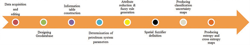
Several distinct steps are involved on the basis of the RFSG for handling uncertainty during the hydrocarbon structures classification. They include identifying the problem, designing a geodatabase, analyzing the RFSG, and producing classification, entropy and cross-entropy maps as results. depicts the meticulous steps which are needed by each stage and are then explained fastidiously in the subsequent sections.
The most focal stage needed when extracting the spatial rule using a GIS-assisted RFSG model is to understand the criteria and objectives during the hydrocarbon exploration procedure. Spatial factors relevant to the hydrocarbon system could be cautiously investigated by the specialists. Having defined the relative attributes of the hydrocarbon system, numerous spatial and non-spatial data could be gathered as a geodatabase. The data has to be processed appropriately in order to obtain a high quality rule extraction analysis. Data pre-processing encompasses diverse stages like investigating the data distribution and outliers, as well as managing the missing values, plus converting data into proper formats and coordinate systems.
An information table was designed as FDIS, according to the geodatabase information layers. The columns of information table include availability likelihood of hydrocarbon system parameters. Based on this table, three mentioned objectives of this research would be accessible by integration of rough set, fuzzy set and granular computing concepts. In order to condition attributes reduction, positive region as a tool for indiscernibility assessment, was applied in a rough set framework. This reduction helps experts make decisions about the classification of hydrocarbon structures due to their geologic chance in an uncomplicated space. Decision attributes were calculated by a GIS-based Delaunay as membership functions. This fuzzification facilitated handling uncertainties which exist in classification process by an uncertainty interval. Finally, two functions from granular computing method were applied for fuzzy rule extraction.
In reliability judgment phase, by the aim of calculating fuzzy entropy and fuzzy cross-entropy values, the precision of classification of hydrocarbon structures was investigated. The extracted rules are required to be ultimately converted into valuable knowledge, meaning that the qualified rules have to be revised and deduced with the aid of proficient experts. Regarding the unusual patterns or results which fail to match with the common practice, it is essential that they be inspected prior to their implementation. The ultimate results will be the knowledge about the classification of the geologic structures consistent with their geologic risks and relevant interval uncertainties.
4. Case study and implementation
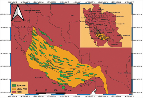
Fars area located in Zagros fold belt in which is illustrated in , Iran entails around 15% of the confirmed gas reserves in the world (Motamedi, Sherkati, and Sepehr Citation2012). Located in Zagros fold-thrust belt in southern Iran, the anticlines in Fars region have been regarded to be exceedingly valuable because they have plentiful hydrocarbons. Furthermore, the region is readily recognized by the North West-South East trending parallel anticlines which verge to the South West (Maleki and Jahadgar Citation2015). According to the geological classification, the study area includes Interior Fars, Sub Coastal Fars, Coastal Fars and Bandar Abbas area. Four hydrocarbon systems, namely, Permian, Jurassic, Tertiary and Cretaceous could be detected in Fars region. Over the past years, various surveys have scrutinized the hydrocarbon system in Fars embayment. By doing so, tectonic and stratigraphic of Zagros and Makran during Mesozoic-Cenozoic were examined by Leturmy and Robin (Citation2010) as a program for Middle East Basins Evolution (MEBE). Additionally, sedimentary evolution of Fars region was undertaken by Piryaei et al. (Citation2011) by inspecting the noticeable changes in fades and thickness of the upper cretaceous succession in Bandar Abbas area. Furthermore, the hydrocarbon systems in consort with the distribution of the oil and gas fields in the Iranian part of the Tethyan Region were explained by Bordenave (Citation2014), Motamedi, Sherkati, and Sepehr (Citation2012) conducted a survey revealing worthwhile information regarding the hydrocarbon system in Fars region.
Figure 2. The study area.
The mainstream of the recognized reservoirs in the area are carbonated, but Asmari and Khami group formations outcrop in the area. Dehram group being linked to Permian would make the mainstream of the examination objective in Fars area. It is of note that Khami, Bangestan and Asmari come next.
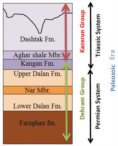
A hydrocarbon system involves a pod of active source rock plus the entire associated oil and gas. Also, it embraces the entire necessary elements and processes which are required for the existence of the oil and gas accumulations (Magoon and Dow Citation1994). The indispensable components include the source, reservoir, seal and overburden rocks, whereas the processes consist of trap formation and the generation-migration-accumulation of the petroleum. The entire necessary components are urged to be placed in time and space by which the processes needed to form a hydrocarbon accumulation would befall. Chronostratigraphic chart of Fars province () shows the age of rocks strata of the study area in relation to time.
Figure 3. Chronostratigraphic chart of Fars province.
Diverse methods could be applied for hydrocarbon prospects classification from the viewpoint of the geological risk and it is noted that every single approach could have their own limitations and advantages. The focal issues were the bulky quantity of the prospects, formations and parameters, which could influence the establishment of the hydrocarbon system. To counter these effects, a novel solution was recommended by this research. As such, the geological risk could be computed for every prospect as Bazan and Szczuka (Citation2001)claimed in one formation, and by taking into account only one parameter of the hydrocarbon system each time and following that the process would proceed for the other prospects and the other parameters, alternately. The formation group stays unchanged and then the Dehram group was concentrated on due to the fact that it forms the majority of the exploration target in Fars area.
The mentioned approach is, however, disadvantaged mainly about uncertainty existing in the knowledge-based process, meaning that once the experts select a membership value to a parameter that named decision attribute in the information table, this number would commonly have a number of uncertainties with itself. Dealing with uncertainty means the uncertainty accompanying an information product has to be stated meaningful terms and measures (Koromorowski et al. Citation1999). This issue, yet, was considered as vagueness relevant to both the fuzzy and rough sets.
This research was undertaken on the hydrocarbon prospects of Fars province in Iran. According to the geologic surveys, among the 246 structures existed in the area; 102 structures were selected to be manipulated in the GIS environment as the train and test data. Every structure had a capability for the hydrocarbon exploration. It is estimated that approximately ten million USD would be required to drill an off-shore hydrocarbon well on each structure. Consequently, any error involved in site selection of the drilling place can result in the huge waste of capital and time. Increasing the quantity of the wells on structures to appropriate locations has been claimed to be a really paramount for the prosperity of the hydrocarbon exploration corporations.
In keeping with numerous hydrocarbon geologic theories and the aid of the professionals from diverse fields, the vital hydrocarbon system parameters such as the source rock factors, the reservoir factors, the trap factors, and the seal rock factors were scrutinized and seven hydrocarbon system variables were examined as the condition attribute for the information table. The mentioned factors include “trap”, “reservoir”, “source”, “seal”, “porosity”, “retention” and “extraction”. The data pre-processing was undertaken to improve the data quality. The spatial data concerning the structures, wells, the sedimentary basin, and their attribute tables were gathered as a geodatabase as a basis for the needed GIS analysis. The extent of each condition attributed gained from five experts and the mean of all the quantities was selected for each attribute. This process was reiterated for all the 102 structures and the measures concerning the chance for the existence of each factor were transformed to four classes as represented in .
Table 1. Classification for the quantity of the condition attributes.
represents the information table of the first five structures () from the original data to demonstrate the classified quantities.
Figure 4. Location of structures in .
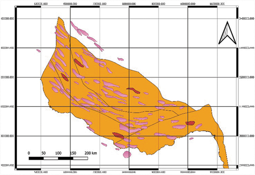
Table 2. The first five rows in the weighted and ranked information table for the hydrocarbon system parameters.
The hydrocarbon exploration in Fars area was spatially clustered, which was substantiated by assessing Moran’s Index by spatial autocorrelation tool in the GIS environment for the sample drilled wells (). Its p-value was roughly 0.09 and the z-score was around 1.7, implying that there was fewer than 10% probability that the incidence of the hydrocarbon system is spatially randomly distributed. Consequently, in keeping with the popular hydrocarbon systems, the adjacent structures would probably have hydrocarbon or not. This could be attributed to the first law of geography (Tobler Citation1970).
Figure 5. Spatial autocorrelation report and its results.
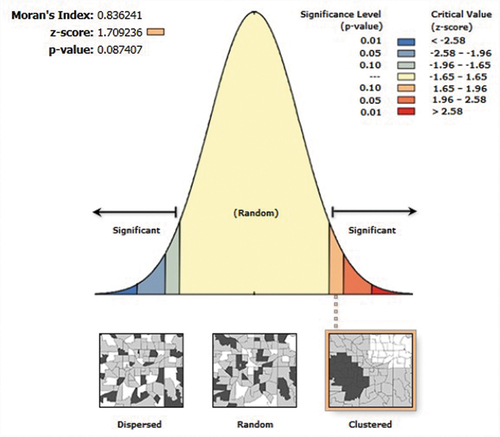
Consequently, in Fars province, we can determine if a structure has hydrocarbon with a high or low geologic chance via the incidence of the hydrocarbon exploration in the adjacent structures. Nonetheless, several exceptions could be regarded for this law in actual fact. The major denial can be attributed to the faults. They can extinguish the conditions of the reservoir rocks as a central portion of two adjacent structures or even one structure. This problem was handled in this study by applying barriers for fault feature class in the geodatabase. The adjacency concept explained at an earlier juncture could be modeled through the fuzzy sets which could be employed as the decision attribute in two levels, namely, Bad Geologic Chance (BGC) and Good Geologic Chance (GGC). The decision attributes membership could be specified as a scenario that is detailed as follows: Primarily, the geologic structures in Fars area could be categorized into two classes, namely the ones with hydrocarbon and without hydrocarbon. A new condition attribute field “Adjacent Structures” would be created for every structure by making use of the Thiessen Polygon analysis in the GIS environment (
Figure 6. Thiessen polygons for calculating the fuzzy membership function.
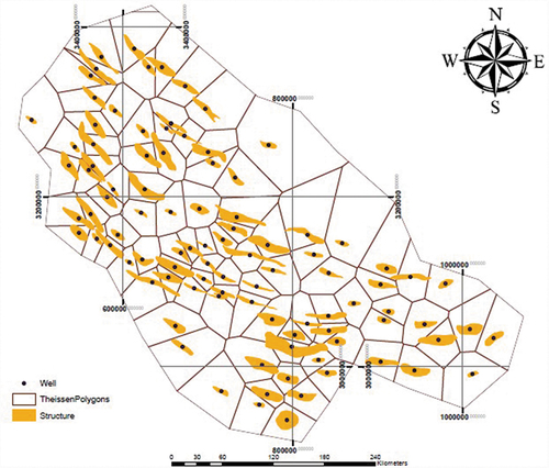
The fuzzification of the decision attribute substitutes the “Adjacent Structures” in the table with related fuzzy membership values ().
Table 3. List of the qualified rules.
4.1. RFSG analysis
The RFSG analysis could be executed having designed the geodatabase and construction of the FDIS table. In this research, the hydrocarbon system parameters were utilized as the condition attributes while two fuzzy decision attributes were chosen as “low approximation of Geologic Chance” and “high approximation of Geologic Chance”. We could use the identified rough set toolkits in order to create positive areas, attribute reductions, and rules. The data has to be categorized into training and test datasets to construct the model and test the validity of the extracted rules, respectively. The derived rules ought to be filtered to facilitate the measures in granular computing. Such measures include generality and absolute support. A threshold was defined for every measure as a filter for the extracted rules. The candidate rules acknowledged by both the generality and absolute support thresholds are considered as the qualified rules to be additionally revised by the experts. 62 structures out of the 102 structures were randomly chosen as the train dataset whereas the 40 remained structures were utilized as the testing dataset. Seven condition attributes existed which include hydrocarbon system parameters and two fuzzy decision attributes concerning the geologic chance of the hydrocarbon exploration. The training dataset was employed to create the reductions and rules by utilizing the positive region concept EquationEquation (5)(5)
(5) for each attribute. Two reductions were derived and 27 rules were created. The algorithm was executed on a genetic based reduction to detect a minimal reduction of the FDIS. The reduction sets were generated as {Trap, Reservoir, Source, Retention, Extraction} and {Trap, Source, Seal, Retention, Extraction} for the FDIS. The conclusion to draw is that removing the porosity in both reductions would be someway reasonable due (Yao Citation2002) to the fact that it is one of reservoir implicit features.
However, it is impossible to exclude the reservoir and porosity instantaneously in actual fact. Therefore, it is necessary to choose the first reduction as the possible situation. By having several trials and errors, it was planned to filter 27 extracted rules by their generality and absolute support values. While benefiting from supervision of five experts from diverse fields and the rule shortening process with granular computing parameters, we could acquire 11 candidate rules. In order to measure the generality and absolute support, we counted the total matching numbers of the structures. Any candidate rules having a generality and absolute support beyond 0.75 was acknowledged as a qualified rule. As a final point, 11 qualified rules along with their related generality and absolute support values were presented in .
It is possible to express the qualified rules in the natural and understandable form of if-then statements. As Chen et al. (Citation2015) stated, such rules are a generalized form of the logical rules that are referred to as the association rules. Even though such keywords as “if” and “then” are employed, the rules are cautioned not to be interpreted as expressing logical implications. As an alternative, they should be employed to simply connect the concepts together (Pawlak and Skowron Citation2007). It should be asserted that, diverse sorts of uncertainties and the properties accompanying the rule are qualified by generality and absolute support.
5. Discussion
It is of note that the entropy-based approaches are employed to appraise the accuracy of the results. Formulas proposed by Shannon (Citation1948) were employed in this research to estimate the entropy and cross-entropy to evaluate the accuracy of fuzzy classification. The entropy formula of a fuzzy set is defined as follows:
where shows the fuzzy degree of
related to class k;
s represents the individual objects; n stands for the total number of the objects; k denotes the individual categories; and c represents the total number of categories. A high value of entropy means an object fit in many classes and therefore is fuzzy; contrarily, a low value means the object has a high membership of only one class and is crisp accordingly. The cross-entropy measures the complementary effect of two different magnitudes: the posterior entropy of the reference probability and the divergence of the classifier posterior from the reference posterior. Here cross-entropy is proposed as a means of evaluating the accuracy of a rough fuzzy classification, by illustrating how closely a rough fuzzy classification represents geologic risk when fuzzy membership is a feature of both the training and test data sets. We could make use of the cross-entropy with the aim to evaluating the accuracy of the fuzzy classification outputs in regard to the fuzzy reference data (Foody Citation1995):
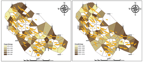
A small value of the cross-entropy implies an accurate classification. In this research, 62 structures were existed as the training data. The sum of all the fuzzy entropies was 51, whereas the average fuzzy entropy was 0.85. Moreover, the standard deviation was 0.031. The sum of all the fuzzy cross-entropy was 10.8, whereas the average fuzzy cross-entropy was 0.18. Furthermore, the standard deviation was 0.148. exhibits the fuzzy entropies and fuzzy cross-entropies of the structures in the training data. As it can be discerned, just seven structures had cross-entropies greater than 0.1 while three structures were larger than 0.3. It is implied that just some structures existed with results significantly different from the train data.
Figure 7. (a) Fuzzy entropy of the results. (b) Fuzzy cross-entropy of the results.
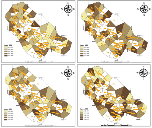
In the RFSG-based model of this study, a structure may be a member of both the lower approximation and upper approximation of the concepts to some degree; in other words, they are fuzzy concepts. The lower and upper approximation for the BGC and GGC are exhibited in .
Figure 8. Structures granulation of the hydrocarbon structures, according to lower and upper approximation of BGC and GGC.
The domain experts revised and talked over 11 extracted fuzzy rules with the aim of interpreting the rules and devising a strategy. It is interesting to know that fuzzy decision rules could be generated by our RFSG framework due to the fact that the RFSG is able to approximate the fuzzy concepts. The conclusion to draw is that the RFSG rules encompass more information in comparison with the classical rules. Consequently, the decision maker can acquire additional information in comparison with the classical rules (Seraj, Delavar, and Rezaee Citation2019).
6. Conclusion
Selecting an appropriate spot for drilling the exploration well on a structure has been claimed to be essential in that any fault in computing the drilling place can result in wasting the capital and time. Notwithstanding such a great deal of investment, hydrocarbon exploration has been referred to as a conventional instance for making decision under risk and uncertainty conditions. In geospatial science, the uncertainty can evidently bring unwanted results to the users thanks to making improper decisions. For this reason, classification of hydrocarbon structures under the uncertainty conditions is a vital tool during hydrocarbon exploration procedure. It facilitates the prioritization of hydrocarbon structure for drilling.
This research has illustrated how the rough–fuzzy concept of a hydrocarbon system parameters could be quantified using RFSG. The work deals with classifying hydrocarbon structures in an information system in which there are fuzzy decision attributes and it proposes a novel approach for handling spatial uncertainty in classification of hydrocarbon structures. The classic rough set or the fuzzy approaches distinctly recommend the location of drilling; however, they are faced by theoretical restrictions which could result in unsuccessful or deceptive interpretations. As a rule-extraction model, the RFSG which is on the basis of the rough fuzzy sets is recommended to extract the spatial fuzzy rules for classifying the hydrocarbon structures in Fars province. Those fuzzy spatial decision rules which are detected by the model are employed in recognizing the uncertainty degree of the existing hydrocarbon in a structure. Therefore, according to condition and decision attributes, there should be more attention to hydrocarbon system parameters when an exploration for hydrocarbon is going on an area. For example, due to our proposed model, rule number 10 could explicate as below:
∙ “IF a structure has 75% chance for trap,
∙ AND the chance for reservoir existence is 100%,
∙ AND source rock entity chance is 75%,
∙ AND extraction chance is 100%
∙ THEN the structure will have 0.34 BGC and 0.66 GGC for hydrocarbon system existence”.
The generality and absolute support values for this rule were 1 and 1, respectively. By computing the reductions as a vital stage throughout the decision making process, they could be applied to detect minimal conditional attributes among numerous parameters associated with the hydrocarbon system, upon which the decision attributes are contingent. The produced fuzzy rules could be applied to foresee or categorize the hydrocarbon structures.
Finally, in our RFSG model, a spatial structure can belong to both the lower and upper approximation of concepts, i.e. these values of concepts are fuzzy. Although our information table can be converted into a classical decision table, it may lose some of the information of the fuzzy sets. For instance, the fuzzy sets cannot be declined too roughly to stipulate appropriate partitioning of the structures which would finally influence the accuracy of classification negatively. Indeed, if the fuzzy sets are divided into too many crisp subsets, the rules extracted from the decision table may be fitted in an exaggerative situation. In considering these, it can be seen that proposed RFSG model is more suitable for hydrocarbon structure classification when our decision table has fuzzy decision attributes.
The model proposed in this work helps in developing tools with more precision in the field of assessing geologic risk of hydrocarbon structures. RFSG considers structures with minimum range of uncertainty (difference between upper and lower approximation), entropy and cross-entropy as best class in terms of drilling. Vice versa it classifies structures with maximum range of uncertainty entropy and cross-entropy as worst class for drilling. Making decisions under these uncertainties is risky. This work opens a way for experts to develop soft computing tools for their future applications.
Acknowledgments
We thank Professor Reza Rezaee from Curtin University for assistance with petroleum system modelling techniques and comments that greatly improved the manuscript.
Disclosure statement
No potential conflict of interest was reported by the author(s).
Data availability statement
The data that support the findings of this study are available from the corresponding author, upon reasonable request (https://www.researchgate.net/profile/Sahand-Seraj-2).
Additional information
Funding
Notes on contributors
Sahand Seraj
Sahand Seraj is currently the head of geospatial database at National Iranian Oil Company (NIOC) in exploration directorate. He received his PhD in GIS from university of Tehran at 2020. ORCID: 0000-0001-7184-5033
Mahmoud Reza Delavar
Mahmoud Reza Delavar is professor of GIS at university of Tehran. He is the director of Center of Excellence in Geomatics Engineering in Disaster Management, School of Surveying and Geospatial Engineering, College of Engineering of Tehran University. He is the Chair of International Society for Photogrammetry and Remote Sensing (ISPRS), WG IV/3. ORCID: 0000-0002-9654-6491
References
- Akram, M., and F. Zafar. 2018. “Multi-criteria Decision-making Methods under Soft Rough Fuzzy Knowledge.” Journal of Intelligent & Fuzzy Systems 35 (3): 3507–3528. doi:10.3233/JIFS-18017.
- Anh, L.D., B. Vo, and W. Pedrycz. 2017. “Information Granulation Construction and Representation Strategies for Classification in Imbalanced Data Based on Granular Computing.” Journal of Information and Telecommunication 1 (2): 113–126. doi:10.1080/24751839.2017.1323476.
- Ashraf, A., M. Akram, and M. Sarwar. 2014. “Fuzzy Decision Support System for Fertilizer.” Neural Computing & Applications 25 (6): 1495–1505. doi:10.1155/2014/695815.
- Balogun, A.L., A.N. Matori, A.I. Hamid-Mosaku, D. Umar Lawal, and I.A. Chandio. 2017. “Fuzzy MCDM-based GIS Model for Subsea Oil Pipeline Route Optimization: An Integrated Approach.” Journal of Marine Georesources & Geotechnology 35 (7): 961–969. doi:10.1080/1064119X.2016.1269247.
- Bargiela, A., and W. Pedrycz. 2003. Granular Computing: An Introduction. Boston: Kluwer Academic Publishers.
- Bazan, J.G., and M. Szczuka. 2001. “RSES and RSES Lib - A Collection of Tools for Rough Set Computations.” The Second International Conference on Rough Sets and Current Trends in Computing, Banff, October 16-29.
- Bordenave, M.L. 2014. “Petroleum Systems and Distribution of the Oil and Gas Fields in the Iranian Part of the Tethyan Region.” AAPG, Memoir, 505–540.
- Chen, H., T. Li, C. Luo, S. Horng, and G. Wang. 2015. “A Decision-theoretic Rough Set Approach for Dynamic Data Mining.” IEEE Transactions on Fuzzy Systems 23 (6): 1958–1970. doi:10.1109/tfuzz.2014.2387877.
- Dubois, D., and H. Prade. 1990. “Rough Fuzzy Sets and Fuzzy Rough Sets.” International Journal of General Systems 17 (2–3): 191–209. doi:10.1080/03081079008935107.
- Foody, G.M. 1995. “Cross Entropy for the Evaluation of the Accuracy of a Fuzzy Land Cover Classification with Fuzzy Ground Data.” ISPRS Journal of Photogrammetry and Remote Sensing 50 (5): 2–12. doi:10.1016/0924-2716(95)90116-V.
- Han, S., H. Zhang, H.X. Guo, and J.H. Cheng. 2014. “A Reservoir Identification Method Based on Rough Set and Support Vector Machine.” International Journal of Computer Applications in Technology 50 (3–4): 196–199. doi:10.1504/IJCAT.2014.066726.
- Heštera, H. 2020. “Analysis of Pedological Factors and USCS in the Contact Area of Đakovo Loess Plateau and Dilj Gora, Croatia.” The Mining-Geological-Petroleum Engineering Bulletin 35 (1): 48.
- Hobbs, J.R. 1985. “Granularity.” The Ninth International Joint Conference on Artificial Intelligence, Los Angeles, August 18-23.
- Hu, Q.H., Z.X. Xie, and D.R. Yu. 2007. “Hybrid Attribute Reduction Based on a Novel Fuzzy-rough Model and Information Granulation.” Pattern Recognition 40 (12): 3509–3521. doi:10.1016/j.patcog.2007.03.017.
- Keet, C.M. 2008. “A Formal Theory of Granularity.” PhD diss, Free University of Bozen-Bolzano.
- Klir, G.J., and B. Yuan. 1995. Fuzzy Sets and Fuzzy Logic: Theory and Applications. New Jersey: Prentice-Hall.
- Koromorowski, J., Z. Pawlak, L. Polkowski, and A. Skowron. 1999. “Rough Sets: A Tutorial.” Rough Fuzzy Hybridization 6 (5): 3–98.
- Leturmy, P., and C. Robin. 2010. “Tectonic and Stratigraphic Evolution of Zagros and Makran during the Mesozoic-Cenozoic: Introduction.” Geological Society, London, Special Publications 330: 1–4. doi:10.1144/sp330.1.
- Leung, Y., M.M. Fischer, W.Z. Wu, and J.S. Mi. 2008. “A Rough Set Approach for the Discovery of Classification Rules in Interval-valued Information Systems.” International Journal of Approximate Reasoning 47 (2): 233–246. doi:10.1016/j.ijar.2007.05.001.
- Lin, T.Y. 2003. “Granular Computing.” The 9th International Workshop on Rough Sets, Fuzzy Sets, Data Mining, and Granular-Soft Computing, Chongqing, May 26-29.
- Liu, H., B. Feng, J. Wei, and W. Li. 2007. “The Oil-Gas Prediction of Seismic Reservoir Based on Rough Set and PSO Algorithm.” IEEE International Symposium on Signal Processing and Information Technology 657–662. doi:10.1109/ISSPIT.2007.4458023.
- Magoon, L.B., and W.G. Dow. 1994. “The Hydrocarbon System: From Source to Trap.” The Annual meeting of the American Association of Petroleum Geologists (AAPG), Dallas, April 7-10.
- Maleki, Z., and F. Jahadgar. 2015. “Folding Style of the Kuh-e Siah Anticline in the Sarvestan Area, Interior Fars, Zagros, Iran.” Open Journal of Geology 5 (8): 552–556. doi:10.4236/ojg.2015.58050.
- Malvic, T., K. Novak, and K.N. Zelenika. 2015. “Indicator Kriging Porosity Maps of Upper Miocene Sandstones, Sava Depression, Northern Croatia.” Materials and Geoenvironment 62: 37–45.
- Malvic, T. 2017. “Stochastic–advantages and Uncertainties for Subsurface Geological Mapping and Volumetric or Probability Calculation.” Materials and Geoenvironment 65 (1): 9–20. doi:10.1515/rmzmag-2018-0003.
- Miao, D., and S. Fan. 2002. “The Calculation of Knowledge Granulation and Its Application.” Journal of Systems Engineering-theory & Practice 1: 7–14. doi:10.1097/TA.0b013e318047c0a9.
- Mohammed, A.M.B., A. Javed, and M.S. Alshayef. 2017. “Spatial Data Modeling Based MCE Fuzzy Logic for Petroleum Exploration in Part of Say’un-Masilah Basin of Yemen.” International Journal of Environment and Geoinformatics 4 (2): 103–115. doi:10.30897/ijegeo.312616.
- Motamedi, H., S.H. Sherkati, and M. Sepehr. 2012. “Structural Style Variation and Its Impact on Hydrocarbon Traps in Central Fars, Southern Zagros Folded Belt, Iran.” Journal of Structural Geology 37: 124–133. doi:10.1016/j.jsg.2012.01.021.
- Nguyen, S.H., A. Skowron, and J. Stepaniuk. 2001. “Granular Computing: A Rough Set Approach.” Computational Intelligence 17 (3): 514–544. doi:10.1111/0824-7935.00161.
- Pawlak, Z., and A. Skowron. 2007. “Rough Sets, Some Extensions.” Information Science 177 (1): 28–40. doi:10.1016/j.ins.2006.06.006.
- Pawlak, Z. 1982. “Rough Sets.” International Journal of Computer & Information Sciences 11 (5): 341–356. doi:10.1007/BF01001956.
- Pawlak, Z. 1991. Rough Sets: Theoretical Aspects of Reasoning about Data. Dordrecht: Springer.
- Piryaei, A., J.J.G. Reijmer, J. Borgomano, and F.S.P. van Buchem. 2011. “Late Cretaceous Tectonic and Sedimentary Evolution of the Bandar Abbas Area, Fars Region, Southern Iran.” Journal of Petroleum Geology 34 (2): 157–180. doi:10.1111/j.1747-5457.2011.00499.x.
- Qian, Y.H., J.Y. Liang, and W. Wei. 2013. “Consistency-preserving Attribute Reduction in Fuzzy Rough Set Framework.” International Journal of Machine Learning and Cybernetics 4 (4): 287–299. doi:10.1007/s13042-012-0090-z.
- Rose, P.R. 2000. Risk Analysis and Management of Petroleum Exploration Ventures. Tulsa: American Association of Petroleum Geologists.
- Seraj, S., and M.R. Delavar. 2018a. “An Extended GIS-based Dempster-Shafer Theory for Play-Based Hydrocarbon Exploration Risk Analysis under Spatial Uncertainty Conditions, Case Study: Zagros Sedimentary Basin, Iran.” Georisk Journal 13 (2): 131–144. doi:10.1080/17499518.2018.1532522.
- Seraj, S., and M.R. Delavar. 2018b. “Play-based Hydrocarbon Exploration under Spatial Uncertainty Using Evidential Theory.” ISPRS Annals of the Photogrammetry, Remote Sensing and Spatial Information Sciences 4 (4). doi:10.5194/isprs-annals-IV-4-193-2018.
- Seraj, S., M.R. Delavar, and R. Rezaee. 2019. “A Hybrid GIS-assisted Framework to Integrate Dempster-Shafer Theory of Evidence and Fuzzy Sets in Risk Analysis: An Application in Hydrocarbon Exploration.” Geocarto International 36 (7): 820–838. doi:10.1080/10106049.2019.1622602.
- Shannon, C.E. 1948. “A Mathematical Theory of Communication.” The Bell System Technical Journal 27 (3): 379–423. doi:10.1002/j.1538-7305.1948.tb01338.x.
- Siahuei, M.R.A., M. Ataei, R. Rafiee, and F. Sereshki. 2021. “Assessment and Management of Safety Risks through Hierarchical Analysis in Fuzzy Sets Type 1 and Type 2: A Case Study (Faryab Chromite Underground Mines).” The Mining-Geological-Petroleum Engineering Bulletin 36 (3): 54. doi:10.17794/rgn.2021.3.1.
- Tobler, W. 1970. “A Computer Movie Simulating Urban Growth in the Detroit Region.” Economic Geography 46 (sup1): 234–240. doi:10.2307/143141.
- Wang, J., and Q. Tao. 2003. Theory of Rough Sets and Statistical Learning. Beijing: Tsinghua University Press.
- Wu, W.Z., J.S. Mi, and W.X. Zhang. 2003. “Generalized Fuzzy Rough Sets Information Sciences.“ Information Sciences Journal 151: 263–282. doi:10.1016/S0020-0255(02)00379-1.
- Yang, Y.J., and R.I. John. 2008. “Generalization of Roughness Bounds in Rough Set Operations.” International Journal of Approximate Reasoning 48 (3): 868–878. doi:10.1016/j.ijar.2008.02.002.
- Yao, J.T. 2008a. “Recent Developments in Granular Computing: A Bibliometrics Study.” IEEE International Conference on Granular Computing, Hangzhou, August 26-28.
- Yao, Y.Y. 2002. “A Generalized Decision Logic Language for Granular Computing.” IEEE International Conference on Fuzzy System, Honolulu, May 12-17.
- Yao, Y.Y., and N. Zhong. 1999. “Potential Applications of Granular Computing in Knowledge Discovery and Data Mining.” Proceedings of World Multiconference on Systemics, Cybernetics and Informatics 5: 573–580.
- Yao, Y.Y. 2008b. A Unified Framework of Granular Computing. Chichester: John Wiley & Sons.
- Zadeh, L.A. 1965. “Fuzzy Sets.” Information and Control 8: 338–353. doi:10.1016/S0019-9958(65)90241-X.
- Zadeh, L.A. 1979. “Fuzzy Sets and Information Granularity.” Advances in Fuzzy Set Theory and Applications 11: 3–18.
- Zadeh, L.A. 1997. “Toward a Theory of Fuzzy Information Granulation and Its Certainty in Human Reasoning and Fuzzy Logic.” Fuzzy Sets and Systems 90 (2): 111–127. doi:10.1016/S0165-0114(97)00077-8.
- Zadeh, L.A. 1999. “From Computing with Numbers to Computing with Words from Manipulation of Measurements to Manipulation of Perceptions.” Circuits Sys 45: 105–119. doi:10.1109/81.739259.
- Zafar, F., and M. Akram. 2018. “A Novel Decision Making Method Based on Rough Fuzzy Information.” International Journal of Fuzzy 20 (3): 1000–1014. doi:10.1007/s40815-017-0368-0.
- Zhou, Z.Y., H.Y. Yu, and X.D. Gu. 2017. “Fuzzy Fusion of Geological and Geophysical Data for Mapping Hydrocarbon Potential Based on GIS.” Petroleum Geoscience 24 (1): 131–141. doi:10.1144/petgeo2016-100.