
Abstract
This study describes the development of a semi-automatic object-based image analysis approach for the detection and quantification of deforestation in Zalingei, Darfur, in consequence of the increasing concentration of refugees or internally displaced persons (IDPs) in the region. The classification workflow is based on a multi-scale approach, ranging from the analysis of high resolution SPOT-4 to very high resolution IKONOS and QuickBird satellite imagery between 2003 and 2008. The overall accuracy rates for the classification of the SPOT 4 data ranged from 92% up to 95%, while those for the QuickBird and IKONOS classification have shown values of 88 and 87%, respectively. The resulting trends in woody vegetation cover were compared with the development of the local population and the variability of precipitation. The results show that the strong increase in human population in the Zalingei IDP camps can be associated with considerable decrease in woody vegetation in the camp vicinity.
Introduction
According to estimates of the UN Refugee Agency (UNHCR Citation2014), there were about 51.2 million displaced people worldwide at the end of 2013, including 16.7 million refugees, 1.2 asylum seekers and 33.3 million internally displaced persons (IDPs). As a result of the numerous conflicts, there were between 4.5 and 5.2 million IDPs across Sudan, before it split in July 2011 (Enough Citation2012) – the largest displaced population in the world. Today, more than six million people are in need of humanitarian assistance in Sudan, while at least two million people are estimated to be internally displaced in Darfur (UN OCHA Citation2014).
On the whole, these people seek refuge in camps because they had to flee their homes due to complex conflict situations or human-made or natural disasters. Most of these camps are under supervision of national and/or international relief organizations, which provide support by supplying the camps with the essential facilities for survival. Living conditions in these camps are extremely difficult. In many cases, there is only limited access to food, water, sanitation and shelter (UNHCR Citation2012). Despite this, most refugee/IDP camps are operated for years and sometimes even decades. The long-lasting and high concentration of people in camps often affects the surrounding environment due to the pressure on natural resources such as wood, water and grazing areas (Tearfund Citation2007; UNEP Citation2007; Gorsevski et al. Citation2012). Thus, especially in vulnerable environments like the semi-arid region of Central Darfur, sustainable management of this impact on the areas surrounding refugee/IDP camps is necessary. This is especially true since the growing pressure on land and water resources, including fire wood and building timber, is an important factor in regional conflicts (Nordås & Gleditsch Citation2007; Raleigh & Urdal Citation2007; Salehyan Citation2008; Bronkhorst Citation2011; Benjaminsen et al. Citation2012) and related population movements (UNEP Citation2007). However, for effective camp management and decision-making, humanitarian organizations require reliable and up-to-date information about the situation on the ground (Bouchardy Citation1995; UNHCR Citation2000, Citation2005). This also comprises the aforementioned assessment of the impact on local and regional resources in order to develop effective mitigation strategies.
Consequently, the main focus of this study is the development of methods for the generation and provision of land cover information for a more reliable and precise documentation of the environmental situation around refugee/IDP camps and changes therein. The major aim is not merely the provision of a profound documentation of land cover changes. This would to a certain extend accuse those people having no alternative to just battling for their existence every day. Rather it is important to utilize the generated Earth observation (EO)-based information as a basis for the provision of a better management of natural resources, the development of mitigation and conflict prevention as well as provisionary measures. Since respective projects are still limited, the United Nations recommend supporting reforestation and afforestation efforts of local, regional and national institutions (UN Sudan Citation2010). Some projects have already been set up responding to growing pressure on natural resources – amongst tree plantations also focussing on fuel conservation measures (UNEP Citation2007; Gafaar Citation2011).
The demand for EO-based information
International relief organizations working globally and supporting people in need sometimes have only very limited knowledge of the prevailing circumstances in the countries and landscapes they are operating in. Thus, geographic information is one of the key factors that need to be assessed for effective humanitarian relief operations (Bouchardy Citation1995; Bjorgo Citation1999; UNHCR Citation2000). Especially in remote areas or regions where geospatial information and detailed map material tends to be inaccurate or even fails to exist, satellite imagery may provide objective and up-to-date information about a given area and thus complement the information about the on-ground situation, which is usually collected by field missions (Bouchardy Citation1995). In cases like Darfur where field assessments are extremely dangerous, if at all possible, due to the complex conflict situations, satellite imagery may be the only reliable source of information. In addition, satellite data provides a unique historical record for examining spatial and temporal changes in the environment. In the context of refugee camp mapping, repeated acquisitions are crucial in order to assess changes in the population of camps as well as the impact on the environment resulting from human activities (e.g. Lodhi et al. Citation1998; Giada et al. Citation2003; Tiede & Lang Citation2009; Kranz et al. Citation2010, Citation2015; Lang et al. Citation2010; Hagenlocher et al. Citation2012).
Conflict and environment – The role of wood
The crisis in Darfur demonstrates that environmental stress can be strongly related to conflict. On the one hand, the long-lasting conflict over environmental resources is one of the major causes of the crisis; on the other hand, the displacement of millions of people and their concentration in camps and at the outskirts of urban settlements has a significant impact on the respective environments (O’Fahey Citation2004; Tearfund Citation2007; UNEP Citation2007; Bromwich Citation2008; Magnus Theisen Citation2008; Leroy Citation2009; UN Sudan Citation2010; Oxfam Citation2014; UNEP/OCHA Citation2014). Thus, the monitoring and quantification of such impacts can be of high value for conflict prevention and the mediation of clashes of interest between the local population and refugees/IDPs.
Although previous studies have indicated that refugees/IDPs have had a negative impact on natural resources in the vicinity of resettlement camps, only few studies have quantified the environmental impact of the growing number of internal and external refugee/IDP flows caused by political, economic or environmental crises (e.g. Lodhi et al. Citation1998; Kranz et al. Citation2010, Citation2015; Spröhnle et al. Citation2010; Hagenlocher et al. Citation2012). However, the detection and the quantification of the impact may provide important information for the management of the camps and thus contribute to a sustainable usage of land resources and the protection of the environment, which in turn, will have a positive impact on the situation of the camp population.
People living in camps are forced to collect wood as source of energy for cooking, brick-making and the construction of dwellings. In addition, for many IDPs, wood is the only source of income (UNEP Citation2008). Due to the uncontrolled exploitation of woody vegetation in Darfur, IDPs may walk up to 15 km (Tearfund Citation2007; UNEP Citation2007) or even 75 km (UNEP Citation2008) to collect wood. This can be extremely dangerous, especially for women and girls who are at risk of rape, harassment and other forms of violence (Women’s Commission Citation2006).
Study area and data
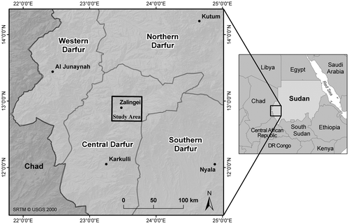
The study area is located in the central part of Darfur, Sudan, and is part of the western Jebel Marra Foreland, in the middle course of the Wadi Azum System between longitudes 23°17.7′E and 23°47.2′E and latitudes 12°41.5′N and 13°5.7′N (see Figure ). With an area of 1200 km2, it comprises the Zalingei IDP camps and town as well as the surrounding environment.
Figure 1. Overview of the study area (black box = extent of HR satellite data).
The Zalingei region is characterized by a semi-arid environment with moderate annual rainfall but a high seasonal variability (eight arid months per year in average). The average total yearly precipitation of about 500–800 mm is generated by a limited number of strong rainfalls and highly concentrated on the wet season during summer, from June to September, with August as the month of maximum rainfall (Ibrahim Citation1984; Giessner Citation1989; UNEP Citation2007; Funk et al. Citation2011; Sorooshian et al. Citation2014). Apart from wood harvesting, the landscape around Zalingei is mainly used as grazing land during the summer rainfall period. The alluvial areas of the major wadi systems are, due to their morphology, more favourable for intensive land use such as cattle herding, rain-fed cultivation and irrigated horticulture (Schrenk Citation1989).
Multispectral SPOT-4 scenes, acquired on 5 October 2003, 6 August 2005 and 26 September 2007, with a spatial resolution of 20 m in the multispectral bands were used for the high resolution (HR) image analysis, covering the Zalingei IDP camps and the surrounding areas with a study area of 40 km × 30 km (see Figure ). The very high resolution (VHR, cf. Moeller Citation2011) analysis was conducted based on IKONOS data acquired on 14 September 2004 and a QuickBird scene from 6 July 2008 covering an area of 10 km × 10 km. An overview on the EO data used and the preprocessing steps applied to the imagery is given in Table .
Table 1. Overview of satellite data specifications and image preprocessing steps.
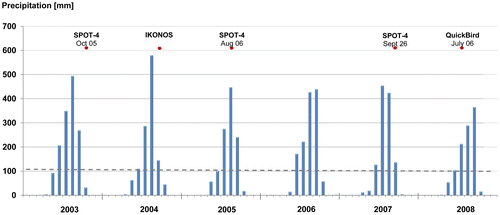
An important factor influencing the growth and vitality of vegetation – including wood resources – is the rainfall variability (Ibrahim Citation1984; UNEP Citation2007; Funk et al. Citation2011; UN Sudan Citation2010; Sorooshian et al. Citation2014). This variability leads to varying phenological conditions throughout the year and even within the different seasons. Due to the high seasonal rainfall variability in Darfur, even satellite data from the same season during consecutive years can be influenced by different phenological conditions. Therefore, for a better understanding of the conditions at the image acquisition dates and for the evaluation of results, precipitation data provided by the Hydrologic Data and Information System (HyDIS; cf. Sorooshian et al. Citation2014) have been used (see Figure ).
When assessing the influence of refugee/IDP camps on their surrounding environment, it is necessary to consider the population dynamics in the camps of the study area over the period of investigation. Thus, population figures have been taken into account to examine if there is a correlation between population growth and vegetation trend patterns. The population data were obtained from the Humanitarian Information Centre Darfur (HIC Darfur Citation2006) and the United Nations Office for the Coordination of Human Affairs (UN OCHA Citation2009). Additional information has been used to gather reliable population figures between 2009 and 2013 to complete the picture (UN OCHA Citation2012, Citation2013). The figures for the camps in Zalingei are visualized in Figure .
Methodology
The methodological workflow of this research is illustrated in Figure . The structure of this chapter follows the sequence presented in this figure (see sections ‘Image preprocessing’ and ‘Image analysis – Object-based feature extraction’). The approach follows a multi-scale impact assessment in order to evaluate possibilities and limitations for the identification of major influencing factors (with the focus on wood resources) at different scales. The aim is not to initially detect ‘hot spots’ of human activity for large regions on HR data that will subsequently further be analysed using higher resolution data. Instead, this study aims to assess the feasibility of using satellite data on different scales and to evaluate the possibilities and limitations of the different data scales for the selected application. In this sense, the analyses at different scales are not depending on each other, which allow the definition of different land cover classes in order to reflect the higher granularity of the VHR imagery.
Figure 2. Methodological workflow.
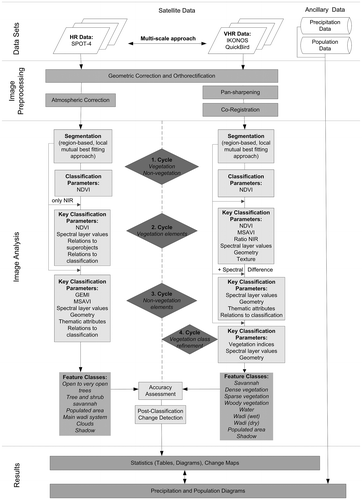
Image preprocessing
Preprocessing steps applied to the HR imagery included ortho-rectification and geometric correction to UTM Zone 34 N (WGS 84) as well as an atmospheric correction using ATCOR (Atmospheric/Topographic Correction for Satellite Imagery after Richter Citation1996). Although data procurement focused on image acquisitions from corresponding seasons in order to reduce the seasonality effect, influences of phenological differences remain, which affect the analysis.
Concerning the VHR data, image preprocessing included geometric correction, ortho-rectification as well as pan-sharpening. Both images were resampled to a common resolution of 1 m using nearest neighbour resampling. This could be regarded as a loss of detail of the QuickBird image, but was necessary to avoid detecting false changes in the subsequent change detection (cf. Serra et al. Citation2003). Atmospheric corrections were not performed, due to the clear sky conditions. In addition, the approach follows a post-classification change detection where atmospheric corrections are not mandatory (Singh Citation1989; Song et al. Citation2001). Finally, the IKONOS and QuickBird images were co-registered to a Ground Sample Distance (GSD) of 1 m in the UTM-Zone 34 N (WGS-84) in order to avoid registration errors. The co-registration was carried out by using a second degree polynomial transformation with 52 ground control points and nearest neighbour resampling with a Root Mean Square Error of 0.76 pixels. A high precision geometric registration was difficult to achieve, because accurate ground control points are scarcely available within this region.
Image analysis – Object-based feature extraction
In the underlying multi-scale approach, first, a broad land cover characterization was conducted analysing a large area around the camps using HR SPOT-4 data. Next, the hierarchical classification was refined by the analysis of VHR QuickBird and IKONOS data, which provided additional information for distinguishing vegetation classes in detail. Although the analyses of the different scales were conducted independently from each other, most of the spectral features used for the HR classification procedure could also be applied for the analysis of the VHR imagery, while geometrical features proved primarily suitable for the VHR analysis.
The object-based image analysis (OBIA, cf. Blaschke Citation2010) was performed using the software eCognition (Trimble Geospatial). Emphasis was put on the definition of a rule set for a hierarchical classification based on stable object characteristics to ensure – to the extent deemed possible – the transferability to other scenes and sensors as well as to diminish the influence of different acquisition times.
Figure gives an overview of the image analysis workflow showing the essential steps of the rule set development including the key classification parameters and the final feature classes. In case of the SPOT data, the rule set was developed for the 2003 scene and transferred to the other scenes with minor adaptations in order to compensate for differences in off-nadir angles, acquisition dates and atmospheric conditions. The rule set for the VHR images was developed for the 2008 QuickBird imagery and transferred to the 2004 IKONOS scene.
The analyses were based on an iterative multi-scale segmentation (Baatz & Schäpe Citation2000) and supervised rule-based classification approach of image objects. Complex class descriptions used for this classification contain spectral information, as well as spatial, geometrical and textural features. Furthermore, thematic attributes, contextual and hierarchical relationships of the image objects as well as object- and pixel-based resizing algorithms were used. Especially for the analysis of vegetation, the Normalised Difference Vegetation Index (NDVI) (Rouse et al. Citation1973) and the Modified Soil Adjusted Vegetation Index (MSAVI) (Qi et al. Citation1994) as well as ratios and textural features have proved suitable. The designated land cover classes refer – within the first hierarchical level, which is based on the SPOT data – to the nomenclature of the UNEP/FAO AfriCover Land Cover Classification System (cf. Di Gregorio & Jansen Citation1998) and have been adapted in order to meet the parameters of the HR data. Within the second hierarchical level, based on the VHR data, this classification is broken down to an even finer subdivision.
The image analysis has been conducted in several cycles, with each cycle starting with a bottom-up, region-growing segmentation (Baatz & Schäpe Citation2000) grouping surrounding pixels according to pre-defined criteria of homogeneity through a combination of different parameters, i.e. scale, colour and shape, to objects of interest. The overall values of the parameters at each cycle were determined by visual inspection of the objects resulting from variations in the parameter weighting. While in most cases, colour was preferred to shape, the scale parameter was set to different values starting with a very fine segmentation (small objects) in the first cycle and steadily increasing, according to the size of objects to be classified.
The initial segmentation was conducted using all available layers. The resulting image objects were considered for the classification and class refinement. The classification process follows a hierarchical scheme, starting with the detection of general land cover categories, i.e. ‘vegetation’ and ‘non-vegetation’ (Figure , 1. Cycle) using the NDVI. These basic classes are further subdivided during the following classification cycles.
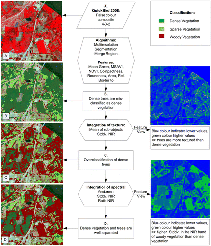
The second cycle aims at the detailed extraction of vegetation elements (see Figure , 2. Cycle), so that only the vegetation class was taken into consideration. For the HR data, it proved suitable to only use the near infrared channel for segmentation. This cycle was most challenging, since difficulties were found in distinguishing between arboreal and grassy vegetation, due to the similar spectral characteristics of these classes. In case of the SPOT data, vegetation indices as well as the information of the green band and the near- and shortwave infrared bands were useful for the detection and distinction of vegetation objects. Thus, for the 2003 image, the separation of closed, open and very open trees was possible. However, due to the different image quality, this detailed classification could not be applied for the 2005 image, since no suitable threshold could be determined to detect trees with a satisfactory result. As a consequence of the high degree of uncertainty, the classes were finally subsumed to the class ‘open to very open trees’. For the VHR data, the separation of vegetation classes was also challenging. However, in contrast to the HR data analyses, the higher spatial resolution of the VHR data allowed the application of additional features, in order to reduce the confusion amongst the vegetation classes. Besides the spectral information of the imagery (vegetation indices, ratios, spectral layer values), textural feature characteristics as well as geometrical features proved suitable for further class distinction. A detailed overview of the extraction scheme for vegetation objects – exemplarily for the QuickBird scene – is given in Figure . The combination of features allowed the detailed distinction of the classes ‘savannah’, ‘dense vegetation’, ‘sparse vegetation’, ‘dense trees and shrubs’ and ‘single trees and shrubs’.
Figure 3. Workflow for the separation of vegetation elements.
In the third cycle, the non-vegetation elements were further investigated focussing on the detection of the main wadi system and the populated area. Due to the existence of clouds in the 2005 SPOT image, the classes ‘clouds’ and ‘cloud shadow’ were additionally introduced. In the first step, the populated area was classified using a thematic layer depicting the camp border. For the HR classification, especially the MSAVI and the Global Environment Monitoring Index (GEMI, Pinty & Verstraete Citation1992) have proved successful for separating the wadi area from the bare soil. Misclassified wadi objects could be removed using geometry features, e.g. length/width and area. In the VHR images, the water could be classified straightforwardly using the information of the near infrared band in combination with the brightness of image objects. The distinction between further wadi classes (wet and dry wadi areas) was more complicated since the spectral characteristics of dry and wet soil are the same in the wadi area as in the surrounding area. In this case, applying knowledge about the spatial behaviour of objects of interest (i.e. the spatial representation of objects as well as the spatial relationship between objects of different classes, e.g. neighbourhood conditions) enabled a more detailed classification. Thus, geometrical and class-related features were used to overcome spectral similarity. For the QuickBird image, which is characterized by dry climatic conditions, a spectral difference segmentation was applied additionally, in order to allow the separation of the dry riverbed and the surrounding dry soil.
Finally, the woody vegetation classes of the VHR classification were refined in a fifth cycle. There were some misclassifications of baobabs and small shrubs, which had no green leaves due to the dry climatic conditions at image acquisition of the QuickBird scene and thus were assigned to the classes ‘savannah’ or ‘sparse vegetation’. The classification could be improved using spectral layer values (MSAVI, green band) in combination with geometrical features such as asymmetry, area and roundness. Final class refinement could be reached by the application of object- and pixel-based resizing algorithms.
Since the study focuses on the changes in woody vegetation cover, the tree and shrub classes were finally merged to the class ‘woody vegetation’.
Accuracy assessment
There are numerous publications dealing with the design and the most important factors to be taken into consideration when carrying out an accuracy assessment either on single data classifications or on change detection analyses results (Congalton & Macleod Citation1994; Dobson et al. Citation1995; Khorram et al. Citation1999; Congalton & Plourde Citation2002; Lu et al. Citation2004; Congalton & Green Citation2009; Wickham et al. Citation2013) also reflecting on object-based approaches (Aguirre-Gutiérrez et al. Citation2012; MacLean & Congalton Citation2012; Hussain et al. Citation2013). In summary, one can state that most commonly used methods such as error matrices strongly build upon ground reference information (Congalton & Macleod Citation1994; Khorram et al. Citation1999; Congalton & Plourde Citation2002; Lu et al. Citation2004). Congalton and Plourde Citation2002 indicate five factors that need to be taken into consideration for a reliable accuracy assessment – amongst them ground reference data collection as the single most important factor (Congalton & Plourde Citation2002). Congalton (Citation1991) points out that already one missing factor will result in significant shortcomings for the accuracy assessment itself (Congalton Citation1991).
Due to the crisis situation in Darfur, no ground reference data were available, even not through NGOs and UN agencies working in the region. For a statistical validation and quantification of the accuracy of the land cover classifications, an accuracy assessment was performed according to Congalton (Citation1991). The classified images were compared to the original satellite data and evaluated by visual interpretation. Stratified random sampling was employed to choose a minimum of 50 sampling points for each category. Using the original satellite data as a basis, producer’s accuracy, user’s accuracy and Kappa coefficients were calculated.
Change detection
In order to quantify the change in woody vegetation in the vicinity of the Zalingei IDP camp, a post-classification comparison was carried out on both the HR and the VHR data. The main aim was to compare the analysis result at different scales in order to identify the major factors influencing the reliability of the results. Additionally, the possibilities and limitations at different scale should be evaluated. Different phenological status, for example, makes a comparison of the HR images difficult, but has only minor influence at single tree detection level on the VHR scenes.
As the main focus of this study is the assessment of the influence of refugee/IDP camps on their surrounding wood resources, only the classes ‘open to very open trees’ for the HR data and ‘woody vegetation’ in case of the VHR imagery served as input for the change detection. Shadows influence the detection of trees, because they partly cover them – especially in clusters of trees. For that reason, the change detection was conducted in two iterations: first including the shadow and second only considering the woody vegetation class.
Results and discussion
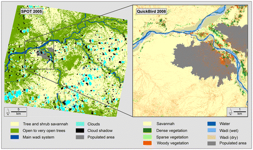
In general, the multi-scale image analysis approach and the hierarchical classification schemes developed show promising results, which are underlined by the high accuracy values. While for the HR scenes only broad land cover categories could be extracted and phenological differences hampered the analysis, the complex picture of structural elements characterizing the landscape pattern of Zalingei has been delineated through the analysis of the VHR data (see Figure ).
Figure 4. Results of the land cover classifications.
Feature extraction
As a general observation of the image classification procedure, the potential of the object-based image analysis could be verified. Using expert knowledge and an iterative analysis process, a satisfactory detection of land cover classes (cf. Figure ) could be obtained.
The study also demonstrates the suitability of additional features (e.g. spatial and contextual information) for the semi-automatic classification of high and very high spatial resolution satellite images in order to overcome the limited spectral resolution. The results from this research agree with previous studies (e.g. Laliberte et al. Citation2004; Puissant et al. Citation2005; Carleer & Wolff Citation2006) which also report an improvement in classification results through the integration of textural features.
Through the region-based classification of the HR SPOT-4 data, the non-vegetation classes have been delineated with a high level of reliability. In contrast, the extraction of vegetation classes was limited by the spatial and spectral resolution of the imagery, different phenological phases during the image acquisition and the higher humidity and cloud coverage in the 2005 data-set which resulted in poorer image quality. Consequently, vegetation elements could hardly be distinguished, even by visual interpretation, and no suitable and transferable threshold could be defined to detect trees with a satisfactory result.
The VHR data analysis was also influenced by different states of phenology at the acquisition dates. In summary, it can be stated that dry seasonal conditions during the QuickBird image acquisition favoured the extraction of single trees, except those with no green leaves. While baobab trees and shrubs could be well identified within the IKONOS image, due to their green leaves, the spectral mixture with the sparse grassland and the savannah led to an underestimation of these classes in the QuickBird classification. However, the relatively high density of the vegetation within the IKONOS image caused confusion amongst the vegetation classes. Especially the distinction of small patches of dense vegetation and close-standing trees was challenging.
Accuracy assessment
A summary of the accuracy values for the classifications is presented in Tables and . All images have a Kappa value of about 0.85, indicating that most of the classes are well described by the developed class descriptors. However, only ground reference data could give absolute evidence of the assumptions. In general, it can be stated that in all images the vegetation classes are not as well identified as the non-vegetation classes, due to the spectral confusion amongst these classes.
Table 2. Results of the accuracy assessment for the HR analysis.
Table 3. Results of the accuracy assessment for the VHR analysis.
The values for the overall classification accuracies of the HR data range from 92.75 to 95% and the overall Kappa statistics from 0.91 to 0.92%.
With an overall accuracy of 88.09% for the QuickBird and 86.87% for the IKONOS scene, the results obtained for both images are very convincing, especially when taking into account the number of classes and the complexity of the landscape. This conclusion is supported by the high overall Kappa coefficients of 0.86 for the QuickBird and 0.85 for the IKONOS scene.
Change detection
The change detection results of the HR data analysis (Figure ) reveal that for the period from 2003 to 2005, there is a drastic decrease in open to very open trees of about 16,866 ha (23%), resulting from an increase of 6456 ha and a decrease of 23,322 ha for that LULC class.
Figure 5. Change in open to very open trees from 2003 to 2007 based on SPOT-4 data (from Spröhnle et al. Citation2010, modified).
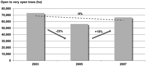
From 2005 to 2007, a total increase in the open to very open trees area of about 10,116 hectares (18%) could be observed, with an increase of 19,363 ha and a decrease of 9247 ha, respectively. However, analysing the vegetation change from 2003 to 2007, an overall decrease of open to very open trees of about 6750 ha (9.2%) is indicated.
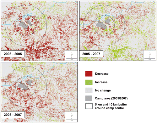
The change maps (see Figure ) show that most areas characterized by vegetation decrease within the years 2003 and 2005 show an increase of vegetation in the years 2005–2007. Furthermore, it can be noticed that within a buffer zone of 10 km around the camp, the area in the south-east and especially in the south-west is most affected by the vegetation degradation during the entire period.
Figure 6. Change maps of open to very open trees resulting from the SPOT-4 data analysis.
Due to the broad structure of the land cover class ‘open to very open trees’, it is not possible to detect subtle changes and to differentiate between arboreal and grass vegetation. Thus, the strong vegetation increase from 2005 to 2007 could be caused by several factors. A feasible explanation for a fractional vegetation increase within this period might be an increase in the agricultural crop land. An additional factor influencing the change detection result can be read from the accuracy assessment: the introduction of the classes ‘clouds’ and ‘cloud shadow’ caused additional confusion in the 2005 scene. It has been assessed that clouds and cloud shadow are slightly underestimated. As a result, there are more areas covered by clouds and cloud shadow in the 2005 scene than are masked out in the other scenes. This could lead to an underrepresentation of vegetation within the 2005 scene. However, these difficulties cannot explain the overall dimension of vegetation increase. The change detection results may rather have been influenced by different precipitation and consequent phenological conditions. For this reason, the precipitation data has been used to get a better estimation of the phenological status at the time of data acquisition (see Figure ). The SPOT data in 2005 was acquired during the main rainy season while the data in 2003 and 2007 were acquired after the main rainy season, in months with a lower rainfall rate. This obviously resulted in different phenological stages of the vegetation which are clearly visible in the respective image.
Figure 7. Precipitation data for Zalingei derived from HyDIS-Data (Sorooshian et al. Citation2014).
Based on the SPOT data, it was not possible to verify whether the trend is caused by decrease/increase of woody vegetation or by a general decrease/increase of the green vegetation cover. Therefore, the VHR data were used to explicitly analyse the tree cover.
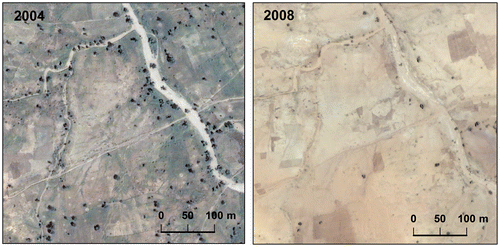
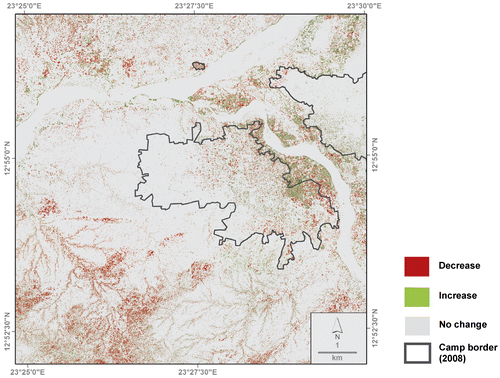
The land degradation becomes evident when comparing the VHR data of 2004 and 2008, which show an obvious decline in woody vegetation in the area surrounding the IDP camps. While areas were still scarcely covered with trees in 2004, they are basically deprived of vegetation in 2008 (see exemplarily Figure ).
Figure 8. Example for decrease in woody vegetation within the study area between 2004 and 2008.
The change detection of the VHR classification results (see Table ) revealed that in 2004, between 809 (without shadow) and 944 ha (with shadow) were covered with woody vegetation. By 2008, the cover reduced to 654 ha. Hence, there is a drastic decline of about 19 (without shadow) to 31 (with shadow) per cent in just four years. Most differences between the two iterations (regarding shadow) can be identified in the direct vicinity of the camp since there is a high accumulation of close standing trees, which are particularly influenced by shadow.
Table 4. Change detection results of the VHR data analysis.
Severely degraded areas can be found in the south and southwest of the camp, within a distance of approximately 5 km. The vicinity of the camp is more secure for gathering wood hence, these areas are exploited most. However, also a vegetation increase within the camp can be observed, which can be explained by the cultivation of trees. This positive trend interferes with the mentioned exploitation of wood resources and explains another observation: The change map (see Figure ) reveals that the elimination of woody vegetation occurred predominantly further away from the IDP camp, especially in those areas where woody vegetation cover originally was more dense due to favouring geographic conditions (e.g. groundwater, soils). In contrast, in the direct vicinity (especially close to the wadi areas), a partial increase in vegetation could be observed which might reflect reforestation and afforestation activities.
Figure 9. Change map of woody vegetation resulting from the VHR data analysis.
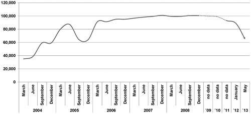
In general, the observed decrease in woody vegetation correlates well with the IDP situation in the Zalingei camps. Population dynamics in the camps between January 2004 and October 2008 (see Figure ) show a considerable increase in the number of IDP’s during this time period; from approximately 30,000 (HIC Darfur Citation2006) to more than 100,000 people while the number of permanent residents stayed constant during the same time (UN OCHA Citation2009).
Figure 10. IDPs in the camps around Zalingei from 2004 to 2013 (HIC Darfur Citation2006; UN OCHA Citation2009, Citation2012, Citation2013).
The post-classification change detection technique presented here is less sensitive to radiometric variations between the scenes and more appropriate when dealing with data captured at different dates (see also Mas Citation1999). In addition, while other techniques only provide change/no-change information, the post-classification comparison provides complete matrices of change information (cf. Lu et al. Citation2004). Nevertheless, it has to be mentioned that change detection is limited by spatial, spectral, thematic and temporal constraints (c.f. Lu et al. Citation2004), especially in semi-arid environments exhibiting a high degree of landscape fragmentation and small structures like individual trees and shrubs. The assessment of the environmental impact of IDP/refugee camps was based solely on a small number of satellite imagery. Thus, the comparison is influenced by different states of phenology. This is especially true for the HR analysis. More robust results could be obtained with a higher temporal resolution, i.e. a high frequency time series.
Finally, it can be ascertained that the described approach and its results have proven to be suitable to verify a substantial impact of IDP camp population on the environment and its natural resources.
Conclusion and outlook
The study demonstrates that the analysis of multi-temporal remote sensing data, supported by ancillary data, is an effective tool for monitoring human-induced environmental changes and degradation of natural resources in the vicinity of refugee/IDP camps. Furthermore, the potential of object-based image analysis for the extraction of different land cover types using HR and VHR satellite data could be demonstrated. It can be stated that the SPOT satellite data were suitable to detect broad land cover classes and the change in vegetation cover, if combined with additional information (e.g. precipitation data). However, for a detailed analysis of land cover changes, VHR satellite imagery is required. Finally, the results suggest that despite the restricted availability of large-scale maps and ground reference data, the predominant land cover changes in woody vegetation in the study area could be monitored accurately by the presented remote sensing approach.
In general, it can be stated that the high increase in human population in the Zalingei IDP camp in 2004 can be associated with considerable changes in the vegetation cover. Woody vegetation appears to have been cleared to generate timber, fuelwood and livestock forage for the local population (UNEP Citation2007). The quantitative information derived from this analysis may be used to enhance the qualitative information available so far (UNEP Citation2008).
The results of this study agree with several previous studies, which assessed a negative influence of the concentration of people in IDP camps on their surroundings. Substantial impact on vegetation has already been observed around camps in Darfur as a whole (UNEP Citation2008; Kranz et al. Citation2010, Citation2015; Spröhnle et al. Citation2010; Hagenlocher et al. Citation2012). A major concern is that in the future almost all fuelwood supplies within walking distance of the camps will be exhausted. This should raise the awareness of decision-makers and should cause relief organizations active in this domain to work towards solutions to the deforestation problem around the IDP camps. The trend patterns derived from the EO-based assessment of the impact of refugee camps on wood resources can provide substantial support to decision-makers in developing strategies mitigating these impacts.
Disclosure statement
No potential conflict of interest was reported by the authors.
Acknowledgements
The paper is based on a Diploma thesis by the first author submitted to Otto-Friedrich-University of Bamberg.
Additional information
Funding
Related Research Data
References
- Aguirre-Gutiérrez J, Seijmonsbergen AC, Duivenvoorden JF. 2012. Optimizing land cover classification accuracy for change detection, a combined pixel-based and object-based approach in a mountainous area in Mexico. Appl Geogr. 34:29–37.10.1016/j.apgeog.2011.10.010
- Baatz M, Schäpe A. 2000. Multiresolution Segmentation an optimization approach for high quality multi-scale image segmentation. In: Strobl J, Blaschke T, Griesebner G, editors. Angewandte Geographische Informationsverarbeitung. Heidelberg: Wichmann; p. 12–23.
- Benjaminsen TA, Alinon K, Buhaug H, Buseth JT. 2012. Does climate change drive land-use conflicts in the Sahel? J Peace Res. 49:97–111.10.1177/0022343311427343
- Bjorgo E. 1999. Very high resolution satellites: a new source of information in humanitarian relief operations. Bull Am Soc Inf Sci Technol. 26:22–24.
- Blaschke T. 2010. Object based image analysis for remote sensing. ISPRS J Photogramm Remote Sens. 65:2–16.10.1016/j.isprsjprs.2009.06.004
- Bouchardy J-Y. 1995. Development of a GIS system in UNHCR for environmental, emergency, logistic, and planning purposes program report. Geneva: DPOS UNHCR.
- Bromwich B. 2008. Environmental degradation and conflict in Darfur: implications for peace and recovery. In: Atkinson R, editor. Humanitarian practice network (HPN). London: Humanitarian Exchange; p. 22–28.
- Bronkhorst S. 2011. Climate change and conflict: lessons for conflict resolution from the Southern Sahel of Sudan. African Centre for the Constructive Resolution of Disputes (ACCORD); [cited 2015 Jan 21]. Available from: http://www.operationspaix.net/DATA/DOCUMENT/4089~v~Climate_Change_and_Conflict__Lessons_for_Conflict_Resolution_from_the_Southern_Sahel_of_Sudan.pdf.
- Carleer AP, Wolff E. 2006. Urban land cover multi-level region-based classification of VHR data by selecting relevant features. Int J Remote Sens. 27:1035–1051.10.1080/01431160500297956
- Congalton RG. 1991. A review of assessing the accuracy of classifications of remotely sensed data. Remote Sens Environ. 37:35–46.10.1016/0034-4257(91)90048-B
- Congalton RG, Green K. 2009. Assessing the accuracy of remotely sensed data: principles and practices. Boca Raton (FL): CRC Press.
- Congalton RG, Macleod RD. 1994. Change detection accuracy assessment of the NOAA Chesapeake bay pilot study. International Symposium on the Spatial Accuracy of Natural Resource Data Bases. Williamsburg (VA): American Society for Photogrammetry and Remote Sensing; p. 78–87.
- Congalton RG, Plourde L. 2002. Quality assurance and accuracy assessment of information derived from remotely sensed data. In: Bossler J, editor. Manual of geospatial science and technology. London: Taylor & Francis; p. 349–361.
- Di Gregorio A, Jansen LJM. 1998. Land cover classification system (LCCS): classification concepts and user manual environment and natural resources service, GCP/RAF/287/ITA Africover – East Africa Project and Soil Resources, Management and Conservation Service, 157pages, FAO, Rome.
- Dobson JE, Bright EA, Ferguson RL, Field DW, Wood LL, Haddad KD, Iredale III H, Klemas VV, Orth RJ, Thomas JP. 1995. NOAA coastal change analysis program; guidance for regional implementation version 10, NOAA technical report NMFS 123, Seattle (WA); p. 92.
- Enough. 2012. Enough 101: Displaced from Darfur – refugees in Chad and IDPs in Sudan; [ cited 2015 Jan 21]. Available from: http://www.enoughproject.org/blogs/enough-101-displaced-darfur-refugees-chad-and-idps-sudan.
- Funk C, Eilerts G, Verdin J, Rowland J, Marshall M. 2011. A climate trend analysis of Sudan, U.S. Geological Survey Fact Sheet 2011–3072. 6 pages.
- Gafaar A. 2011. Forest plantations and woodlots in Sudan. African Forest Forum Working Paper Series 1. African Forest Forum; Nairobi.
- Giada S, De Groeve T, Ehrlich D, Soille P. 2003. Information extraction from very high resolution satellite imagery over Lukole refugee camp, Tanzania. Int J Remote Sens. 24:4251–4266.10.1080/0143116021000035021
- Giessner K. 1989. Die räumlich-zeitliche Niederschlagsstruktur im westlichen Jebel-Marra-Vorland und deren hydrologische Auswirkungen [The spatio-temporal precipitation structure in the western Jebel-Marra Foreland and its hydrological effects]. In: Mensching H, editor. Aktuelle morphodynamische Prozesse im Einzugsbereich des unteren Atabra (Nile Province, Rep. Sudan) und im westlichen Vorland des Jebel Marra (Darfur, Rep. Sudan) [Current morpho-dynamic processes in the drainage basin of the lower Atabra river (Nile Province, Rep Sudan) and in the western Jebel-Marra Foreland (Darfur, Rep Sudan)]. Hamburg: Krause-Druck; p. 79–125.
- Gorsevski V, Kasischke E, Dempewolf J, Loboda T, Grossmann F. 2012. Analysis of the Impacts of armed conflict on the Eastern Afromontane forest region on the South Sudan – Uganda border using multitemporal Landsat imagery. Remote Sens Environ. 118:10–20.10.1016/j.rse.2011.10.023
- Hagenlocher M, Lang S, Tiede D. 2012. Integrated assessment of the environmental impact of an IDP camp in Sudan based on very high resolution multi-temporal satellite imagery. Remote Sens Environ. 126:27–38.10.1016/j.rse.2012.08.010
- HIC Darfur. 2006. Humanitarian information centre – Darfur humanitarian profile; [ cited 2010 Jun 18]. Available from: www.humanitarianinfo.org/darfur/infocentre/HumanitarianProfile/index.asp.
- Hussain M, Chen D, Cheng A, Wei H, Stanley D. 2013. Change detection from remotely sensed images: from pixel-based to object-based approaches. ISPRS J Photogramm Remote Sens. 80:91–106.10.1016/j.isprsjprs.2013.03.006
- Ibrahim FN. 1984. Ecological Imbalance in the Republic of the Sudan – with reference to desertification in Darfur, Bayreuther Geowissenschaftliche Arbeiten vol. 6. Bayreuth: Druckhaus Bayreuth Verlagsgesellschaft.
- Joint UNEP/OCHA Environment Unit. 2014. Environment and humanitarian action increasing effectiveness, sustainability and accountability version 11, August 2014, Geneva; [ cited 2015 Jan 21]. Available from: http://www.urd.org/IMG/pdf/EHA_Study_web_FINAL.pdf.
- Khorram S, Biging GS, Chrisman NR, Colby DR, Congalton RG, Dobson JE, Ferguson RL, Goodchild MF, Jensen JR, Mace TH. 1999. Accuracy assessment of remote sensing derived change detection. Bethesda: American Society for Photogrammetry and Remote Sensing, Monograph Series; pp. 64.
- Kranz O, Lang S, Tiede D, Zeug G, Kemper T, Caspard M, Clandillon S. 2010. GMES services for conflict prevention and mitigation: support the DG RELEX in mission planning. In: Konecny M, Zlatanova S, Bandrova TL, editors. Geographic information and cartography for risk and crisis management towards better solutions. Berlin: Springer; p. 171–188.10.1007/978-3-642-03442-8
- Kranz O, Sachs A, Lang S. 2015. Assessment of environmental changes induced by internally displaced person (IDP) camps in the Darfur region, Sudan, based on multitemporal MODIS data. Int J Remote Sens. 36:190–210.10.1080/01431161.2014.999386
- Laliberte AS, Rango A, Havstad KM, Paris JF, Beck RF, McNeely R, Gonzalez AL. 2004. Object-oriented image analysis for mapping shrub encroachment from 1937 to 2003 in southern New Mexico. Remote Sens Environ. 93:198–210.10.1016/j.rse.2004.07.011
- Lang S, Tiede D, Hölbling D, Füreder P, Zeil P. 2010. Earth observation (EO)-based ex post assessment of internally displaced person (IDP) camp evolution and population dynamics in Zam Zam, Darfur. Int J Remote Sens. 31:5709–5731.10.1080/01431161.2010.496803
- Leroy M, editor. 2009. Environment and conflict in Africa reflections on Darfur. Addis Ababa: University for Peace.
- Lodhi MA, Echavarria FR, Keithley C. 1998. Using remote sensing data to monitor land cover changes near Afghan refugee camps in northern Pakistan. Geocarto Int. 13:33–39.10.1080/10106049809354626
- Lu D, Mausel P, Brondízio E, Moran E. 2004. Change detection techniques. Int J Remote Sens. 25:2365–2401.10.1080/0143116031000139863
- MacLean MG, Congalton RG. 2012. Map accuracy assessment issues when using an object-oriented approach. In: Proceedings of the American Society for Photogrammetry and Remote Sensing 2012 Annual Conference; Sacramento (CA).
- Magnus Theisen OM. 2008. Blood and soil? Resource scarcity and internal armed conflict revisited. J Peace Res. 45: 801–818.10.1177/0022343308096157
- Mas JF. 1999. Monitoring land-cover changes: a comparison of change detection techniques. Int J Remote Sens. 20:139–152.10.1080/014311699213659
- Moeller M. 2011. Systemvergleich hochauflösender optischer Satellitenfernerkundungssensoren [Comparison of high resolution optical remote sensing satellite sensor systems]. In: Strobl J, Blaschke T, Griesebner G, editors. Angewandte Geoinformatik 2011. Beiträge zum 23. AGIT Symposium, Salzburg [Angewandte Geoinformatik 2011. Contributions to the 23rd AGIT Symposium]. Wichmann: Heidelberg; p. 1–9.
- Nordås R, Gleditsch NP. 2007. Climate change and conflict. Polit Geogr. 26:627–638.10.1016/j.polgeo.2007.06.003
- O’Fahey RS. 2004. Conflict in Darfur historical and contemporary perspectives. In: Environmental Degradation as a Cause of Conflict in Darfur. Conference Proceedings; Khartoum: University of Peace.
- Oxfam 2014. We no longer share the land. Agricultural change, land, and violence in Darfur. 184th Briefing Paper; Oxford; 2014 Apr 21.
- Pinty B, Verstraete MM. 1992. GEMI: a non-linear index to monitor global vegetation from satellites. Vegetatio. 101:15–20.10.1007/BF00031911
- Puissant A, Hirsch J, Weber C. 2005. The utility of texture analysis to improve per-pixel classification for high to very high spatial resolution imagery. Int J Remote Sens. 26:733–745.10.1080/01431160512331316838
- Qi J, Chehbouni A, Huete AR, Kerr YH, Sorooshian S. 1994. A modified soil adjusted vegetation index. Remote Sens Environ. 48:119–126.10.1016/0034-4257(94)90134-1
- Raleigh C, Urdal H. 2007. Climate change, environmental degradation and armed conflict. Polit Geogr. 26:674–694.10.1016/j.polgeo.2007.06.005
- Richter R. 1996. Atmospheric correction of satellite data with haze removal including a haze/clear transition region. Comput Geosci. 22:675–681.
- Rouse JW, Haas RH, Schell JA, Deering DW. 1973. Monitoring vegetation systems in the Great Plains with ERTS. Third ERTS Symposium, NASA SP-351 I, Washington (DC); p. 309–317.
- Salehyan I. 2008. From climate change to conflict? No consensus yet. J Peace Res. 45:315–326.10.1177/0022343308088812
- Schrenk H. 1989. Agrare Landnutzung und Morphologie am mittleren Wadi Azum (westliches Jebel-Marra-Vorland) [Agricultural land use and morphology at the middle course of the Wadi Azum (western Jebel-Marra Foreland)]. In: Mensching H, editor. Aktuelle morphodynamische Prozesse im Einzugsbereich des unteren Atabra (Nile Province, Rep Sudan) und im westlichen Vorland des Jebel Marra (Darfur, Rep Sudan) [Current morpho-dynamic processes in the drainage basin of the lower Atabra river (Nile Province, Rep Sudan) and in the western Jebel-Marra Foreland (Darfur, Rep Sudan)]. Hamburg: Krause-Druck; p. 127–144.
- Serra P, Pons X, Saurí D. 2003. Post-classification change detection with data from different sensors: some accuracy considerations. Int J Remote Sens. 24:3311–3340.10.1080/0143116021000021189
- Singh A. 1989. Review article digital change detection techniques using remotely-sensed data. Int J Remote Sens. 10:989–1003.10.1080/01431168908903939
- Song C, Woodcock CE, Seto KC, Lenney MP, Macomber SA. 2001. Classification and change detection using landsat TM data. Remote Sens Environ. 75:230–244.10.1016/S0034-4257(00)00169-3
- Sorooshian S, Hsu K, Imam B, Hong Y. 2014. Hydrologic data and information system (HyDIS) department of civil and environmental engineering. Irvine: University of California; [ cited 2015 Jan 21]. Available from: http://chrs.web.uci.edu/persiann/data.html.
- Spröhnle S, Schoepfer E, Kranz O. 2010. Abschätzung der Umweltauswirkungen von Flüchtlingslagern mithilfe multitemporaler Fernerkundungsdaten am Beispiel des Camps Zalingei in Westdarfur. In: Strobl J, Blaschke T, Griesebner G, editors. Angewandte Geoinformatik 2010. Beiträge zum 22. AGIT Symposium, Salzburg; Heidelberg: Wichmann; p. 697–1302.
- Tearfund. 2007. Darfur: relief in a vulnerable environment; [ cited 2015 Jan 21]. Available from: http://www.tearfund.org/webdocs/website/Campaigning/Policy%20and%20research/Relief%20in%20a%20vulnerable%20envirionment%20final.pdf.
- Tiede D, Lang S. 2009. IDP camp evolvement analysis in Darfur using VHSR optical satellite image time series and scientific visualization on virtual globes. In: Guo H, Wang C, editors. Proceedings of SPIE 7840, Sixth International Symposium on Digital Earth: Models, Algorithms, and Virtual Reality. Beijing: SPIE; p. 7.
- UNEP. 2007. Sudan. Post-conflict environmental assessment. United Nations Environment Programme, Nairobi; [ cited 2015 Jan 21]. Available from: http://postconflict.unep.ch/publications/UNEP_Sudan.pdf.
- UNEP. 2008. Destitution, distortion and deforestation. The impact of conflict on the timber and woodfuel trade in Darfur. Geneva: United Nations Environment Programme; [ cited 2015 Jan 21]. Available from: http://postconflict.unep.ch/publications/darfur_timber.pdf.
- UNHCR. 2000. Key principles for decision-making refugee operations and environmental management engineering and environmental service section. The UN Refugee Agency, Geneva; [ cited 2015 Jan 21]. Available from: http://www.unhcr.org/3b03b24d4.html.
- UNHCR. 2005. Environmental guidelines. The UN Refugee Agency, Geneva; [ cited 2015 Jan 21]. Available from: http://www.unhcr.org/3b03b2a04.html.
- UNHCR. 2012. The state of the world’s refugees. In search of solidarity. The UN Refugee Agency, Geneva; [ cited 2015 Jan 21]. Available from: http://www.unhcr.org/4fc5ceca9.html.
- UNHCR. 2014. UNHCR global trends 2013 war’s human cost. The UN Refugee Agency, Geneva; [ cited 2015 Jan 21]. Available from: http://www.unhcr.org/5399a14f9.html.
- UN OCHA. 2009. Darfur humanitarian needs profile; [ cited 2015 Jan 21]. Available from: http://reliefweb.int/sites/reliefweb.int/files/resources/Darfur_Profile_10Mar14_A3_portrait.pdf.
- UN OCHA. 2012. SUDAN: Darfur IDP camps ( as of 01 Jan 2012); [ cited 2015 Jan 21]. Available from: https://docs.unocha.org/sites/dms/CAP/sud11_darfur_idpcamps_a3_23feb12.pdf.
- UN OCHA. 2013. SUDAN: Darfur IDP camps ( as of 08 May 2013); [ cited 2015 Jan 21]. Available online: http://reliefweb.int/sites/reliefweb.int/files/resources/Darfur%20IDP%20camps%2008%20May%202013%20New.pdf.
- UN OCHA. 2014. Sudan: humanitarian snapshot [ 2014 Mar 31; cited 2015 Jan 21]. Available online: http://reliefweb.int/sites/reliefweb.int/files/resources/Sudan_Snapshot_March%202014.pdf.
- UN Sudan. 2010. Beyond emergency relief longer-term trends and priorities for UN agencies in Darfur. United Nations Sudan, Khartoum; [ cited 2015 Jan 19]. Available from: http://www.unep.org/disastersandconflicts/Portals/155/countries/sudan/pdf/consultations/Darfur_%20Recovery_Beyond%20Emergency%20Relief.pdf.
- Wickham JD, Stehman SV, Gass L, Dewitz J, Fry JA, Wade TG. 2013. Accuracy assessment of NLCD 2006 land cover and impervious surface. Remote Sens Environ. 130:294–304.10.1016/j.rse.2012.12.001
- Women’s Commission. 2006. Finding trees in the desert: firewood collection and alternatives in Darfur. Women’s Commission for Refugee Women and Children, New York, NY; [ cited 2015 Jan 21]. Available from: http://www.refworld.org/docid/48aa82ec0.html.