
Abstract
This study focuses on the identification of potential neolithic sites in Southeast Anatolia, specifically those contemporary to Göbeklitepe. While several neolithic sites have been explored in the region, there is a possibility of undiscovered sites. Accurate identification and location of these sites present challenges. To address this, we employed a novel approach that integrates the analysis of visibility maps and the presence of cisterns near known neolithic sites. Through the utilization of an SRTM DEM and GIS, visibility maps of the neolithic sites were generated, capturing the extent of their visibility. Additionally, a spatial clustering analysis was conducted on 115 cisterns identified during field surveys. By intersecting the visibility maps and cistern clusters, we identified nine potential neolithic sites with promising archaeological significance. This method not only offers a pathway for the discovery of new neolithic sites in the region but also presents a valuable framework that can be applied to other areas to enhance our comprehensive understanding of the neolithic period. Our research contributes to the field by providing insights into the methodology of neolithic site identification and highlighting its potential for future archaeological investigations in the region.
1. Introduction
In recent years, archaeological studies have uncovered a significant number of neolithic sites in the southeast region of Anatolia, with Göbeklitepe in Upper Mesopotamia, Şanlıurfa being one of the most widely recognized. The megalithic structures at Göbeklitepe are considered key indicators of the transition from hunter-gatherer societies to the establishment of early farming communities (Notroff et al. Citation2014). These monumental structures demonstrate the innovative capabilities of Pre-Pottery neolithic societies, as evidenced by the presence of monolithic T-shaped pillars, which suggest the development of new architectural and engineering technologies, as well as the existence of specialized craftsmen and the emergence of hierarchical social structures. In recognition of these important features, Göbeklitepe was inscribed on the UNESCO World Heritage List in 2018 (UNESCO Citation2022).
The southeastern region of Anatolia holds a significant place in the study of Pre-Pottery neolithic settlements. Ongoing archaeological research in the region has led to the discovery of numerous neolithic sites, particularly over the past three decades. These include Nevali Çori (Hauptman Citation1999), Göbeklitepe (Beile-Bohn et al. Citation1998; Schmidt Citation2000), Şanlıurfa Yeni Mahalle (Çelik Citation2000b), Karahantepe (Çelik Citation2000a), Sefertepe (Çelik Citation2006) and Taşlıtepe (Çelik et al. Citation2011), which represent a range of settlement and cult centers. The Ministry of Culture and Tourism has promoted these neolithic sites, which have been identified as cult centers, under the Taş Tepeler (Stone Hills) project (Ministry of Culture and Tourism Citation2022). The discovery of these neolithic settlements adds to the likelihood of the existence of other neolithic sites in the region (Karul Citation2021). As understood from the study of Özdoğan (Citation2022), new neolithic areas such as Mendik and Söğüt Tarlası and Biris Mezarlığı were discovered in the region apart from the stone hills.
Due to the expansive nature of neolithic sites, it can be challenging to identify potential areas for further investigation through traditional field surveys. In light of this, a more holistic and systematic approach is necessary. In this context, spatial analysis and remote sensing methods utilizing Geographic Information System (GIS) technology have proven to be effective tools in archaeological research. For example, Bachagha et al. (Citation2020) used high-resolution satellite imagery within a GIS environment to identify morphological features of potential archaeological sites. Siart et al. (Citation2008) employed a GIS-based method combining both terrestrial and remote sensing data to identify spatial patterns of archaeological sites. Garcia (Citation2013) proposed a GIS-based approach for determining archaeological site locations based on factors such as altitude, topography and image classification. In a similar vein, Di Iorio et al. (Citation2010) utilized high-resolution radar images and GIS to observe and identify unexplored archaeological sites in Egypt.
In recent years, the integration of GIS technology with archaeological research has led to significant advancements in the field. Studies such as Polat (Citation2023) have explored the application of drones and GIS in investigating ancient water collection and storage systems near neolithic sites, providing valuable insights into past civilizations. Price et al. (Citation2023) have utilized a spatial approach using GIS and pedestrian survey data to enhance archaeological prospection at sites like Tell Abu Shusha in Israel. These studies demonstrate the potential of GIS technology in uncovering hidden archaeological features and expanding our understanding of ancient landscapes. Furthermore, the practical application of the Harris Matrix, a method for spatio-temporal interpretation of topographical data, has been effectively employed in GIS-based stratigraphic analysis (Doneus et al. Citation2022). Drones, photogrammetry and GIS interpretations have also proven beneficial in examining extended archaeological contexts, as exemplified by Orsini et al. (Citation2022) in their study of Tacuil in Argentina. Moreover, the integrated GIS-based approach has been instrumental in reconstructing palaeogeographical landscapes and conducting archaeological surveys, as demonstrated by Sander and Kriiska (Citation2022) in their research on coastal palaeolagoons in Western Estonia. These examples highlight the diverse applications of GIS in archaeology, ranging from site investigation to landscape reconstruction. Additionally, Guechi et al. (Citation2023) have utilized a GIS-AHP-GeoTOPSIS model to predict archaeological site locations in desert areas, showcasing the potential of GIS as a predictive tool. The contributions of these studies, along with others in the field, have significantly advanced our understanding of past civilizations and the methodologies used in archaeological research.
The data and methods described in the aforementioned studies are not applicable in our current context. For instance, high-resolution RGB satellite images are not usable for this research because of several reasons. Firstly, the archaeological sites of interest in this study are primarily underground, with limited or no visible indicators on the surface. Optical satellite images, which are commonly used in archaeology, cannot effectively capture these subsurface features. Additionally, dense vegetation in the study area further hampers the visibility of potential archaeological sites, making interpretation from satellite imagery challenging. Consequently, archaeologists rely on field surveys, where teams physically examine the landscape, to identify and locate such sites. While satellite imagery is an invaluable resource for archaeological research, it was not suitable for this particular study due to the nature of the sites and the limitations of optical imagery. In radar systems, which is another approach, it is difficult for microwave signals to penetrate the ground due to the rocky nature of the study area. Regarding the use of drones, it is acknowledged that they have become increasingly prevalent in archaeology. Although drones are primarily employed for documentation and observation purposes, their applications in the field are expanding. However, in the context of this study, the technical limitations of drones need to be considered. The study area covers a wide expanse, making it impractical to collect data using civilian-use drones due to their limited coverage and flight capabilities.
The rapid changes in topography also make it challenging to distinguish archaeological settlements from natural surface features. Given these constraints, we have chosen to rely on the three common characteristics of neolithic sites in the region as a basis for identifying potential locations: high altitude of settlements, visibility of settlements and the presence of cisterns for water storage. Ancient civilizations tend to be located at higher elevations than their surroundings. Settling in high areas had both practical and security-related considerations, as the high elevations offered a defensive advantage. This also applied to the observation of hunting herds (Jones Citation2006). In our case, the neolithic sites in the region are located on the peaks of Tektek Mountains.
When examining the patterns of habitation in ancient civilizations, it is apparent that they constructed a variety of architectural structures, including houses, palaces, roads and specialized edifices such as temples, in strategic and prominent locations. The visibility of architectural structures in ancient civilizations, specifically their placement in conspicuous and advantageous locations, played a key role in the establishment and maintenance of social and spatial order (Maschner Citation1996; Richards-Rissetto Citation2017). Furthermore, the visibility of the contemporary settlements and their built forms becomes even more significant when considering their spatial proximity to one another. In light of the above considerations, the proximal nature of the neolithic sites under investigation in the study region is particularly noteworthy with regards to visibility.
Water, as a vital resource for human survival, has been a fundamental aspect of human civilization throughout history, necessitating effective management Polat (Citation2023). The management of water is a crucial requirement for the well-being of any society and its individual members (Berking et al. Citation2019). Since ancient times, ensuring an adequate water supply has remained a perpetual concern in arid and semi-arid regions across the world (Elmakayes et al. Citation2023). Water has been a primary determinant for the emergence and sustainability of human settlements, influencing factors such as accessible water resources, fertile soil, altitude, slope, slope direction, proximity to permanent water sources and communication paths (Dastenaei and Mohsen Citation2023). Throughout history, various societies have constructed structures such as canals, dams, arches, wells and cisterns in order to access water (Fagan Citation2011). Among these infrastructures, cisterns are considered to be the most widely utilized. This can be observed in the South of Mora, where the cisterns in the Byzantine castle on the summit of Monemvasia remain intact, as well as in the Greek and Roman city of Morgantina in Sicily, where cisterns were used to collect rainwater from the roofs of houses, and in the ancient city of Petra in Jordan, where cisterns were carved into rock (Gilb Citation1998). The origins of cisterns are uncertain, however, a popular theory posits that they were first created by an individual who excavated a hole and lined it with a suitable material in order to establish a permanent water storage facility. Therefore, cisterns enabled communities living in arid regions to sustain themselves and overcome the difficulties posed by limited water resources. In the study area, it is significant that cisterns for water storage are located in close proximity to neolithic sites. In this study, we utilized GIS technology to identify potential locations for new neolithic sites based on the three common features previously identified in this region: high altitude, visibility and the presence of cisterns for water storage.
2. Study area and data
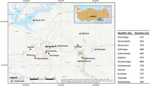
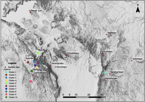
The study area is located in the northeastern section of the Fertile Crescent, in the southeast region of Anatolia and encompasses the surrounding areas of the city of Şanlıurfa. The region has a variety of natural features such as the Harran, Suruç, Ceylanpınar Plains, Tektek Mountains and the Euphrates River. The neolithic sites within the region are predominantly constructed on the local peaks of the Tektek Mountains, as depicted in .
Figure 1. Study area and neolithic site locations.
The Digital Elevation Model (DEM) data necessary for this study was obtained from the Shuttle Radar Topography Mission (SRTM) dataset. The SRTM data, which is produced by the National Aeronautics and Space Administration (NASA), utilizes microwave sensors and covers the entire globe, with a spatial resolution ranging from 30 to 90 m. The data is made freely available, particularly for academic purposes.
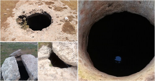
Tektek Mountains region is characterized by the presence of a significant number of cisterns that have been carved into the limestone rock formations of the terrain. A 1-year field study conducted as part of this research identified 115 cisterns within the study area. Although some of these cisterns were previously known due to their proximity to neolithic sites, the majority were discovered through the systematic survey of the field, and through the accounts of local inhabitants. The locations and images of the identified cisterns were meticulously recorded. A selection of cistern images obtained through field survey are presented in .
Figure 2. Sample cisterns images from field survey.
3. Methods
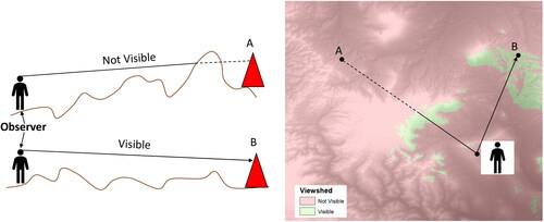
The concept of visibility in the field of archaeology refers to the visibility of settlements, monuments and other artifacts of a past culture from a certain observer location. The viewshed analysis has been widely used in archaeological research as a powerful tool to understand the factors that shape the distribution and organization of settlements, monuments and other cultural features. This approach allows for a comprehensive examination of the visibility conditions of a given site, and thus, it has been a valuable method in the interpretation of past human activity and decision-making processes (Fraser Citation1983; Kvamme Citation1993; Wheatley Citation1995; Lock and Harris Citation1996; Maschner Citation1996; Lake and Woodman Citation2003; Jones Citation2006).
In the context of GIS, visibility can be analyzed quantitatively through the use of viewshed analysis. This methodology incorporates the utilization of a DEM as the primary data input in order to calculate the visibility from a specified observer location. By analyzing the presence and location of topographical obstacles that might obstruct the line of sight from the observer location, viewshed analysis generates a resultant raster image, which differentiates between visible and not visible regions, as illustrated in .
Figure 3. Basic illustration of viewshed.
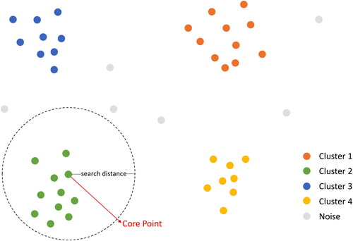
Spatial clustering analysis is a method that can be employed to identify groups of points based on their geographic locations and given parameters. One commonly used density-based clustering algorithm is Density-based Spatial Clustering of Applications with Noise (DBSCAN), which utilizes two key parameters: search distance and minimum features per cluster. The algorithm begins by selecting an initial point as a core point, and then proceeds to identify neighboring points within the specified search distance. This process is then repeated for each additional point within the cluster, until there are no further points to add. If a cluster meets the criterion of the minimum features per cluster parameter, it is classified as a high-density cluster. Conversely, clusters that fail to meet this criterion are considered low-density clusters, and may be deemed noise ().
Figure 4. Density-based cluster identification from raw data.
4. Results
The DEM necessary for the visibility analysis of the study area was procured through the use of the SRTM DEM dataset. The SRTM DEM provides an appropriate level of detail for inferring topographical features, enabling the clear differentiation of features such as the Harran plain, the peaks of the Tektek Mountains, and the valleys.
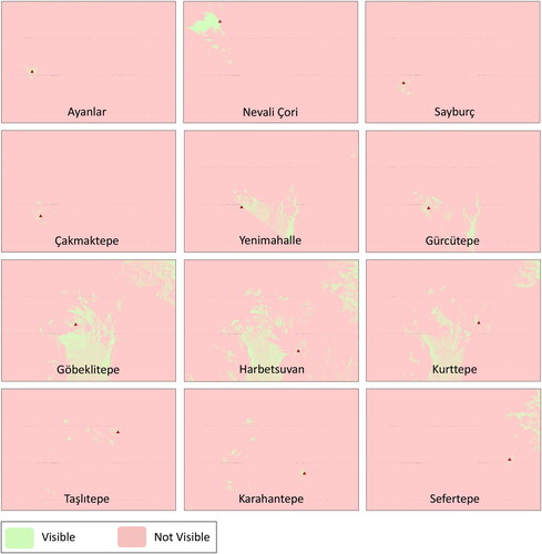
In the present study, SRTM data was utilized to conduct viewshed analysis in order to determine the visible areas from the vantage points of neolithic sites. It is important to note that the results of viewshed analysis, which is a point-based methodology, may vary depending on the location and elevation of the points selected within a neolithic site, as these sites are areas rather than single points. To mitigate this issue, the highest point within each neolithic site was first identified as the center point and a circle with a radius of 100 m was created. Subsequently, eight additional points were established at cardinal and intercardinal directions on this circle (). By conducting viewshed analysis for each of these points, the visible and not visible regions for each neolithic site were determined ().
Figure 5. Determination of observing points.
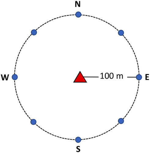
Figure 6. Visibility maps of neolithic sites.
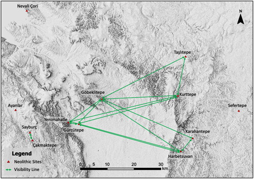
The resulting visibility maps and the locations of the neolithic sites were then utilized to identify visibility lines connecting each neolithic site to the others, as illustrated in . As can be seen from the results, the neolithic sites of Nevali Çori, Ayanlar and Sefertepe were found to be not visible from any other neolithic sites. This is likely due to their geographic locations, as Nevali Çori and Ayanlar are situated on the western side of the Harran Plain and Sefertepe is located on the easternmost edge. Conversely, Göbeklitepe, which is situated at the center of the other neolithic sites, emerged as the most visible neolithic site, being able to be seen from six different neolithic sites.
Figure 7. Visibility lines determined between neolithic sites.
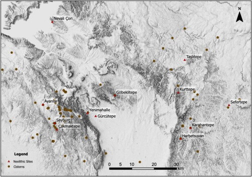
As previously discussed, the presence of cisterns may have played a role in the initial phases of site selection for the neolithic settlements. An examination of the spatial distribution of the cisterns reveals that a majority of them are situated in the Tektek Mountains, as evidenced by .
Figure 8. Spatial distribution of identified cisterns.
It is of particular interest that some of the cisterns are situated in close proximity to the extant neolithic sites. Furthermore, a visual examination reveals that certain cisterns are aggregated in specific locations. In order to analyze this clustering pattern, DBSCAN algorithm was implemented within a GIS environment (). The algorithm employed a minimum of 3 cisterns per cluster and a search distance of 500 m as parameters for this analysis. These parameters were chosen based on the results of the preliminary analyses.
Figure 9. Density-based clusters of cistern locations.
As a result of the clustering analysis, 52 out of the 115 cisterns were identified as belonging to ten distinct clusters, and the remaining cisterns were classified as noise. Of the nine clusters located in the west of the Harran plain, the remaining cluster was situated in the east of the Harran plain. As it would not be practical to analyze the visibility of each neolithic site individually with respect to all clusters, an integrated map was created by summing the visibility of each neolithic site. This map was then overlaid with the clusters to illustrate their distribution in relation to the visible area ().
Figure 10. Intersection of clusters and total visible area.
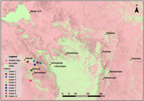
The results of the overlay analysis revealed that nine clusters were located within the visible region, while one cluster (Cluster 9) remained outside. It is worth noting that Cluster 10 was found to overlap with the neolithic site of Sayburç. The proximity of the clusters to the extant neolithic sites is also noteworthy.
5. Discussion
The generated view shed maps allow us to gain an understanding of the visibility hinterland of the neolithic sites. Comparing our findings with existing approaches, our study offers a more comprehensive examination of the visibility range by integrating GIS technology with field surveys. While previous studies have focused on individual neolithic sites, our approach considers the spatial relationships and patterns among multiple sites in the Şanlıurfa region. This provides a broader perspective on the settlement dynamics during the neolithic period. For instance, while Göbeklitepe, Kurttepe and Harbetsuvan neolithic sites are at different elevations and orientations in relation to the Harran plain, they primarily overlook the plain. Conversely, Gürcütepe and Yenimahalle, which are located within the Harran plain, have a less expansive view of the plain due to their lower elevations. Karahantepe, which is situated in close proximity to Harbetsuvan, does not have a view of the plain due to the surrounding highlands, but does have direct sightlines to the western side of the plain. The field of view of Sefertepe is oriented towards the direction where Tektek Mountains end and the Viranşehir plain begins. Nevali Çori’s field of view primarily encompasses the deep and wide valley opened by the Euphrates River. The viewing areas of Taşlıtepe, Ayanlar, Sayburç and Çakmaktepe do not have a dominant direction and are shaped according to the surrounding highlands in the area.
In terms of comparisons with other approaches, our study reveals that the visibility patterns of the neolithic sites are influenced by the surrounding topographic highlands. This is in line with Richards-Rissetto (Citation2017) Maya kings choosing high hills to build highly visible temples, who also highlighted the significance of topographic features in shaping the visibility range of settlements. However, our study extends beyond individual site analysis by incorporating advanced GIS techniques and spatial clustering analysis of cisterns to identify potential new neolithic sites. Furthermore, our findings demonstrate that the majority of neolithic sites in the Şanlıurfa region have direct lines of sight to each other, forming a chain of visibility. This observation is consistent with the studies of Bachagha et al. (Citation2020), which emphasized the interconnectedness and spatial relationships among linear defensive structure and forts related to the Imperial Roman period. However, our study contributes by providing a more detailed analysis of the specific neolithic sites within this chain of visibility, such as the central location of Göbeklitepe and its direct sightlines to multiple other sites.
By examining all these viewshed maps in combination, the visibility lines of the neolithic sites in relation to one another were inferred. In terms of spatial distribution, it is apparent that Göbeklitepe is situated in the center, offering a direct view to six neolithic sites: Taşlıtepe, Kurttepe, Karahantepe, Harbetsuvan, Gürcütepe and Yenimahalle. This observation suggests a chain of visibility among the majority of neolithic sites, reinforcing the supposition that new neolithic sites would also be incorporated into this chain. Given the current number and distribution of neolithic sites, Sefertepe, Ayanlar and Nevali Çori do not have a view of any other neolithic sites. The remaining neolithic sites have varying numbers of visible neolithic sites. However, this supposition alone is insufficient for locating potential new sites. Therefore, the role of cisterns becomes crucial in identifying additional neolithic site locations that could complete the chain of visibility. Cisterns, found in proximity to existing neolithic sites, played a vital role in water storage for survival, making their presence significant in the identification of potential neolithic sites.
Our study contributes to the existing research on neolithic settlement patterns by providing a comprehensive understanding of the landscape. Previous studies primarily focused on individual site analyses, overlooking broader spatial relationships (Jones Citation2006; Siart et al. Citation2008; Richards-Rissetto Citation2017). In contrast, our comprehensive GIS-based approach integrates visibility analysis and cistern distribution, refining the identification of potential neolithic sites. By examining multiple sites in the Şanlıurfa region, we fill a gap in the literature and highlight Göbeklitepe as a central site with direct lines of sight to others. Our study advances the understanding of neolithic settlement patterns, offering insights into factors influencing site selection and a systematic framework for exploration.
Upon examination of the distribution of cisterns, it is evident that they are concentrated in certain regions while scarce in others. The causes for this sparsity can be attributed to several factors. Firstly, there may simply be a lack of cisterns in the area aside from those already identified. Secondly, other cisterns in the region may not have been discovered. Thirdly, cisterns may naturally fill and disappear over time, and lastly, they may be filled and sealed off by local inhabitants. It cannot be stated that every cistern is indicative of the presence of a neolithic site. Nonetheless, regions where cisterns are clustered are considered to possess a higher potential for the presence of a neolithic site.
When examining the results of the spatial clustering of cisterns and visibility analysis together, it has been determined that nine out of the ten cistern clusters identified are located within the visible regions of existing neolithic sites. This supports the hypothesis that visibility was a factor considered in the placement of these neolithic settlements. The analysis of the spatial clustering of cisterns and visibility patterns in our study contributes to the existing body of research on neolithic settlement patterns, while also providing new insights into the relationship between settlements and visibility considerations. Our findings align with previous studies that have recognized the significance of visibility and water management in neolithic civilizations (Berking et al. Citation2019; Guechi et al. Citation2023; Polat Citation2023).
By comparing our integrated approach to previous studies, we provide a more comprehensive understanding of neolithic settlement dynamics. While earlier research focused on individual site analyses, neglecting broader spatial relationships and patterns among neolithic sites (Siart et al. Citation2008; Richards-Rissetto Citation2017), our study utilizes advanced GIS technologies and spatial analyses to quantitatively examine the relationship between cistern clusters and visibility. Our analysis supports the hypothesis that visibility influenced the selection of neolithic settlement locations. The presence of nine cistern clusters within visible areas reinforces the deliberate consideration of visibility in site placement, shedding light on ancient communities’ efforts to secure essential resources and establish communication networks. Furthermore, our study highlights the potential for discovering new neolithic sites beyond the current visible regions, expanding previous research and emphasizing the dynamic nature of visibility in uncovering additional settlements in the future.
The results of the applied method may be subject to variation depending on a number of parameters. Firstly, the choice of point locations for visibility analysis may have an impact on the visible regions as well as the regions where cistern clusters are located. Secondly, the cisterns that could not be identified in the study area may also alter the distribution of clusters. Additionally, the parameters used in the DBSCAN algorithm directly affect the identification and number of clusters. Lastly, the discovery of new neolithic sites may alter the sightlines and visibility map.
6. Conclusion
In conclusion, this study employed a GIS-based approach to identify potential new neolithic sites in the Şanlıurfa region, contributing to our understanding of the neolithic period and expanding upon existing research. By integrating visibility analysis and cistern distribution, spatial relationships and patterns among neolithic sites were revealed, shedding light on the settlement dynamics of this era. The utilization of GIS technology in conjunction with field surveys enabled a comprehensive examination of the landscape, unveiling potential site locations and providing valuable insights into the cultural and social aspects of neolithic communities. The findings of this study highlight the significance of Göbeklitepe as a central site within the neolithic landscape, with direct lines of sight to multiple other sites. Furthermore, the identification of clusters of cisterns within visible areas emphasizes the importance of water storage infrastructure in shaping settlement patterns. These observations contribute to our understanding of the decision-making processes and considerations undertaken by ancient communities during the establishment of neolithic settlements.
It is important to acknowledge the limitations of our study, such as the reliance on available data and the speculative nature of identifying potential sites. Further archaeological investigations are required to validate the existence and characteristics of the identified locations. Nonetheless, the combined approach of visibility analysis and cistern distribution offers a promising framework for future research and field exploration in the Şanlıurfa region. Moreover, this study contributes to the existing body of literature on GIS applications in archaeology, showcasing the value of spatial analysis techniques in uncovering hidden patterns and potential new sites. By integrating traditional field surveys with advanced GIS technology, our understanding of neolithic civilizations and their interaction with the surrounding landscape is enhanced.
In summary, our research provides valuable insights into the neolithic period in the Şanlıurfa region, laying the groundwork for further investigations and contributing to the broader understanding of ancient civilizations. The identified neolithic sites and their spatial relationships serve as a foundation for future studies, fostering a deeper comprehension of the cultural and historical significance of the region. The utilization of GIS-based approaches and the integration of visibility analysis and cistern distribution offer a promising avenue for continued research and exploration in this field.
Acknowledgments
The author expresses their gratitude to head of Karahantepe excavation Prof. Dr. Necmi KARUL for their invaluable support.
Disclosure statement
No potential conflict of interest was reported by the authors.
Data availability statement
The data not available due to privacy of ongoing archaeological excavations.
Additional information
Funding
References
- Bachagha N, Wang X, Luo L, Li L, Khatteli H, Lasaponara R. 2020. Remote sensing and GIS techniques for reconstructing the military fort system on the Roman boundary (Tunisian section) and identifying archaeological sites. Remote Sens Environ. 236:111418. doi: 10.1016/j.rse.2019.111418.
- Beile-Bohn M, Gerber C, Morsch M, Schmidt K, Geiss M, Obermeier S. 1998. Neolithische Forschungen in Obermesopotamien-Gürcütepe und Göbekli Tepe. Istanb Mitt. 48:5–78.
- Berking J, Oleson JP, Sürmelihindi G, Nenci E, Maganzani L, Ronin M, Schrakamp I, Gerrard C, Gutiérrez A, Trümper M, et al. 2019. Water management in ancient civilizations. 7–17. Humboldt-Universität zu Berlin. ISSN (Online) 2366-665X. doi: 10.17171/3-53.
- Çelik B, Güler M, Güler G. 2011. A new pre-pottery neolithic settlement in Southeastern Turkey: Taslı Tepe. Anadolu. 37:225–236.
- Çelik B. 2000a. A new early neolithic settlement: Karahan Tepe. Neo-Lithics. 2:6–8.
- Çelik B. 2000b. An early neolithic settlement in the center of Sanliurfa Turkey. Neo-Lithics. 2(3):4–6.
- Çelik B. 2006. A new early neolithic settlement in Southeastern Turkey: Sefer Tepe. Neo-Lithics. 06-1. 23–25.
- Dastenaei MH, Mohsen D. 2023. Determining The optimal settlement locating of ancient sites using Topsis multi-criteria decision model: a case study: establishments in mountainous areas of North Khorasan, Northeast Iran. JAHA. 10(1):52–67. doi: 10.14795/j.v10i1.787.
- Di Iorio A, Straccia N, Carlucci R. 2010. Advancement in automatic monitoring and detection of archaeological sites using a hybrid process of remote sensing GIS techniques and a shape detection algorithm. In Proceedings of the 30th EARSeL Symposium Paris France; p. 53–63.
- Doneus M, Neubauer W, Filzwieser R, Sevara C. 2022. Stratigraphy from topography II. The practical application of the Harris Matrix for the GIS-based spatio-temporal archaeological interpretation of topographical data. Archaeologia Austriaca. 106:223–252. doi: 10.1553/archaeologia106s223.
- Elmakayes Y, Ben-Shlomo D, Anker Y, Frumkin A. 2023. Water as a strategic resource in the Western Samaria Region–The Unique Case of Deir Sam’an: the water system that has been operating for 1,500 years. Environ Archaeol. 1–15. doi: 10.1080/14614103.2023.2213021.
- Fagan B. 2011. Elixir: a history of water and humankind. New York: Bloomsbury Publishing USA.
- Fraser D. 1983. Land and society in Neolithic Orkney parts I and II. BAR Publishing.
- Garcia A. 2013. GIS-based methodology for Palaeolithic site location preferences analysis. A case study from Late Palaeolithic Cantabria (Northern Iberian Peninsula). J Archaeol Sci. 40(1):217–226. doi: 10.1016/j.jas.2012.08.023.
- Gilb CL. 1998. Water management in ancient Greek cities. Comp Civiliz Rev. 38:8.
- Guechi I, Gherraz H, Korichi A, Alkama D. 2023. Predicting archaeological sites locations in desert areas, using GIS-AHP-GeoTOPSIS model: Southwestern Algeria, Bechar. Archaeologies. 19, 471–499. doi: 10.1007/s11759-023-09479-0.
- Hauptman H. 1999. The Urfa Region Neolithic in Turkey: the cradle of civilization new discoveries. İstanbul: Arkeoloji ve Sanat Yayınları (M. Özdoğan, editor.)
- Jones EE. 2006. Using viewshed analysis to explore settlement choice: a case study of the Onondaga Iroquois. Am Antiq. 71(3):523–538. doi: 10.2307/40035363.
- Karul N. 2021. Buried buildings at pre-pottery Neolithic Karahantepe. Türk Arkeol ve Etnogr Derg. 82:21–31.
- Kvamme KL. 1993. Computer methods: geographic information systems; appendix B. In Haas J, Creamer, W, editors. Stress and Warfare Among the Kaventa Anasazi of the Thirteenth Century A. D., Fieldiana Anthropology New Series, No. 21, Chicago: Field Museum of Anthropology; p. 171–180.
- Lake MW, Woodman PE. 2003. Visibility studies in archaeology: a review and case study. Environ Plann B Plann Des. 30(5):689–707. doi: 10.1068/b29122.
- Lock GR, Harris TM. 1996. Danebury revisited: a English Iron age hillfort in a digital landscape. In Anthropology space and geographic information systems. Oxford: Oxford University Press.
- Maschner HDG. 1996. The politics of settlement choice on the Northwest coast: cognition GIS and coastal landscapes. In Anthropology space and geographic information systems. New York: Oxford University Press.
- Ministry of Culture and Tourism. 2022. Stone Hills Introductory Meeting. https://basin.ktb.gov.tr/TR-294077/tas-tepeler-tanitim-toplantisi-sanliurfa39da-yapildi.html.
- Notroff J, Dietrich O, Schmidt K, Osborne JF. 2014. Building monuments creating communities: approaching monumentality in archaeology. IEMA Proc. 3:83–105.
- Orsini C, Benozzi E, Williams V, Rossi P, Mancini F. 2022. UAV photogrammetry and GIS interpretations of extended archaeological contexts: the case of Tacuil in the Calchaquí area (Argentina). Drones. 6(2):31. doi: 10.3390/drones6020031.
- Özdoğan E. 2022. The Sayburç reliefs: a narrative scene from the Neolithic. Antiquity. 96(390):1599–1605. doi: 10.15184/aqy.2022.125.
- Polat N. 2023. An investigation of ancient water collection and storage systems near the Karahantepe neolithic site using UAV and GIS. Environ Archaeol. 1–13. doi: 10.1080/14614103.2023.2216530.
- Price SJ, Adams MJ, Tepper Y. 2023. An integrated spatial approach to archaeological prospection using GIS and pedestrian survey data at Tell Abu Shusha, Israel. Archaeol Prospect. 30(2):233–247. doi: 10.1002/arp.1888.
- Richards-Rissetto H. 2017. An iterative 3D GIS analysis of the role of visibility in ancient Maya landscapes: a case study from Copan Honduras. Digit Scholarsh Humanit. 32(suppl_2):ii195–ii212.
- Sander K, Kriiska A. 2022. An integrated result of Gis-based approach to palaeogeographical reconstructions and archaeological surveys of coastal Palaeolagoons at the mouths of the rivers Vihterpalu, Teenuse and Velise (Western Estonia). EJA. 26(2):184. doi: 10.3176/arch.2022.2.04.
- Schmidt K. 2000. Göbekli Tepe and the rock art of the near East-Göbekli Tepe ve Ön Asya Kaya Resim Sanati. TÜBA-AR. 3:1–14.
- Siart C, Eitel B, Panagiotopoulos D. 2008. Investigation of past archaeological landscapes using remote sensing and GIS: a multi-method case study from Mount Ida Crete. J Archaeolog Sci. 35(11):2918–2926. doi: 10.1016/j.jas.2008.06.006.
- UNESCO. 2022. UNESCO World Heritage Convention-Göbeklitepe. [accessed 2022 Dec 20] https://whc.unesco.org/en/list/1572/.
- Wheatley D. 1995. Cumulative viewshed analysis: a GIS-based method for investigating intervisibility and its archaeological application. In Archaeology and GIS: a European perspective. London: Routledge.