
 ?Mathematical formulae have been encoded as MathML and are displayed in this HTML version using MathJax in order to improve their display. Uncheck the box to turn MathJax off. This feature requires Javascript. Click on a formula to zoom.
Abstract
This study selected ten condition factors from the perspectives of topography, geological structure, hydrology and human for mining subsidence mapping by two types of models (knowledge-driven model and data-driven model) by taking Jining City, China as an example. The knowledge-driven model is achieved by analytic hierarchy process (AHP), and the data-driven model is achieved by frequency ratio (FR), combined with fuzzy comprehensive evaluation (FCE) and entropy evaluation method (EWM). Based on these models, the areas under receiver operating characteristic curve are 0.777, 0.949, and 0.938, which means FR-FCE obtained the highest accuracy. The differences reflected by the three methods are concentrated in Liangshan County and central to northern areas of Weishan County. The best model was proposed for the protection measures and land use management. Finally, the factors system and methods used in this study can be widely applied to the mining subsidence susceptibility evaluation in plain areas.
1. Introduction
The importance of mineral resources to human activities is beyond doubt. In China, the increasing population and urban development consumed massive of mineral resources, which resulted in a large number of mined-out areas and mining subsidence issues (Dong et al. Citation2015). Mining subsidence is a serious and widespread problem that the ground gradually sinks or subsides due to the subsidence or demolition of underground mines (Malinowska et al. Citation2018; Kim and Lee Citation2020). This may lead to structural damage to buildings and infrastructure, as well as economic losses and potential safety hazards (Kowalski et al. Citation2021). Many mines are abandoned after resource depletion and underground mines around the world often experience subsidence, which has a significant impact on human production activities and the living environment.
In recent years, the wide application of GIS has provided a powerful technical means for subsidence assessment and played a guiding role in geological hazards such as mining subsidence. Subsidence susceptibility mapping is an important tool for land use planners, engineers and government agencies to help manage and minimize the risks associated with mining subsidence. By identifying the areas most prone to subsidence, appropriate land use policies and development regulations can be implemented to avoid or reduce the risks associated with land movement. As a serious geological hazard, the study of subsidence has been carried out long ago. According to the material composition of surrounding rock, subsidence can be mainly divided into three types: karst collapse, soil cave subsidence and mining subsidence. And research directions are mainly major in karst collaspse or subsidence caused by some minerals in karst basins, or study the susceptibility of sedimentation under the environmental conditions in arid and semi-arid areas (Yilmaz Citation2007; Yilmaz et al. Citation2011; Santo et al. Citation2017; Xie et al. Citation2022). As a special geological hazard in the mining area, the principle of mining subsidence is the ground subsidence caused by the weight of the upper rock and soil layer under the excavation space. Its degree and quantity depend on the combined effect of multiple factors
Existing research contents include Unlu et al. (Citation2013) built a model using GIS and the mining information system, analyzed the model, determined the subsidence caused by mining, and compared the results with GPS, and obtained a new method of applying mining subsidence. Martinez-Moreno et al. (Citation2016) used the microgravity prospection positioned with differential GPS to get subsidence susceptibility maps supported by the residual gravity anomaly contours. There have been many studies on mining area evaluation based on multiple-criteria decision analysis (MCDA): Choi et al. (Citation2010) used fuzzy operators to integrate eight main factors into the subsidence risk coefficient, obtained the mining subsidence susceptibility map, and tested it in an abandoned underground coal mine in South Korea. Oh and Lee (Citation2010), using the weights-of-evidence model in the Bayesian probability models, selected seven main factors and developed hazard prevention and land use planning applicable to the vicinity of abandoned mining areas. Suh et al. (Citation2013) used FR to establish rating levels for the eight-factor layers selected, AHP to establish weights and combined the two models to get susceptibility maps with high accuracy (97% and 94%). Zhang et al. (Citation2016) used fuzzy comprehensive evaluation and AHP, developed a new susceptibility evaluation system to define the mining subsidence risk in the mining area. Tzampoglou and Loupasakis (Citation2017) used a semi-quantitative method weighted linear combination, finished subsidence susceptibility map at Candado hill. Wu et al. (Citation2018) have finished the coal-mining area ground stability evaluation by using a fuzzy comprehensive evaluation method. Alaee et al. (Citation2019) is based on fuzzy theory and uses several α Cutting, the subsidence is defined as fuzzy form and applied to the prediction of mining subsidence. Chang et al. (Citation2022) proposed a relatively complete evaluation factor system to assess the multi- hazards risk that considers the evaluation processes of hazard susceptibility, and vulnerability in mining areas. MCDA is well suited for the study of mining subsidence as it offers a wide range of methods that can be applied. Moreover, it is also capable of establishing a targeted evaluation system in a variety of geological environments. The method is widely used and highly accurate.
Machine learning has the function of large-scale nonlinear modeling for input and output samples. Compared with the MCDA model, machine learning can effectively handle the nonlinear relationship between subsidence points and various environmental factors, determine the required parameters, and obtain more objective results. It has also been widely applied in the field of subsidence prediction. Mohammady et al. (Citation2019) evaluated the susceptibility of land subsidence in arid and semi-arid areas using random forest machine learning theory, and the AUC conclusion was 0.77, Oh et al. (Citation2019) quantitatively identified vulnerable areas in abandoned coal mining areas by using Bayesian functional and meta-ensemble machine learning models. Based on a comparison of the AUC values of the susceptibility maps of land subsidence among various models, found that the Logit boost model (a meta-ensemble machine learning model) has a prediction accuracy of 91.44%, higher than the Bayesian functional model (86.42%). Lee et al. (Citation2012) used the artificial neural network to select eight indicators and carried out ten verifications, and the prediction accuracy was between 94.84% and 95.98%. Su et al. (Citation2021) selected three machine learning algorithms, Decision Tree (C5.0), Random Forest (RF), and Support Vector Machine (SVM),tested whether underground mined areas and ground subsidence in coal mine areas seriously affect the occurrence of landslides. Li et al. (Citation2020) selected 108 subsidence points, 11 environmental factors, five different connection methods and four data-based models(Probability Statistics (PSs), Frequency Ratio (FR), Information Value (IV), Index of Entropy (IOE) and Weight of Evidence (WOE))and four data-based models (Analytic Hierarchy Process(AHP), Multiple Linear Regression(MLR), C5.0 Decision Tree(C5.0 DT) and Random Forest(RF)for relevant research, and concluded that WOE-RF is more suitable for prediction of subsidence susceptibility than other models. Although machine learning methods have achieved good results, there are also some potential drawbacks, such as the need for a large amount of high-quality data to effectively train the model. In some cases, the data may be complete or inaccurate, which may lead to biased or inaccurate predictions. In addition, machine learning methods may not directly incorporate domain knowledge or expert input. Mining subsidence is a serious geological hazard associated with human activities that requires expert knowledge to explain the results or to determine important factors that can reduce sensitivity. Machine learning cannot accurately predict the impact of human activities, which is also a disadvantage.
In the field of mining subsidence, because the mining process is seriously affected by human factors, the machine learning model has poor results in predicting the parameters related to human activities. Even if the prediction results are acceptable, it is still a question worth exploring whether it is applicable. Therefore, it is more worth discussing how to properly use the model to solve the problem of mining subsidence susceptibility prediction. The methods used in this paper include AHP, frequency ratio-entropy evaluation method (FR-EWM) and frequency ratio-fuzzy comprehensive evaluation (FR-FCE). AHP is more dependent on the view of experts. The entropy weight rule is that when the data is more dispersed, the entropy value is smaller. It can be considered that the data contains more information, so the weight is larger. FCE can make an overall evaluation of things or objects subject to multiple factors. The results are clear and systematic, which can better solve fuzzy and difficult to quantify problems, and is suitable for solving various uncertain problems. Through the combination of the data-driven method with the knowledge-driven method, the accuracy and objectivity of the evaluation results are better achieved when the evaluation subject involves human activities. Before this study, no scholar has combined AHP, FR-FCE and FR-EWM to complete the mining subsidence susceptibility assessment. This paper aims to evaluate and validate mining subsidence susceptibility by using these three methods, compare the accuracy of data-driven models and knowledge-driven models, analyze their advantages, choose a more appropriate and effective method for future research to solve such problems, and provide usable insights into preventing and controlling mining subsidence in these areas.
2. Study area and data set
2.1. Study area
Jining City, with the coverage of 11.19 million km2 and a population of 8.36 million in 2020, is located in the southwest of Shandong Province, China (between latitude 34°26′–35°57′ North and longitude 115°52′–117°36′ East) (). It is formed by the accumulation of alluvial materials. The largest freshwater lake in northern China is Nansi Lake, which located in the south of Jining City, with 1266 km2 maximum water surface. The Beijing-Hangzhou Canal runs through the study area from north to south. The topography of Jining City is dominated by plain depressions. In comparison to the west, the terrain in the east is low, with elevations ranging from 4 m to 639 m. The geology in Jining City ranges from Ordovician to Quaternary, of which the Quaternary is widely distributed in the central and western plains and the eastern mountainous depressions and valleys, with abundant clay, silt, medium-fine sand and coarse sand. The climate of Jining City is warm temperate monsoon, with the average temperature ranging from 13.3 °C to 14.1 °C and 667.82 mm annual average precipitation. The spatial distribution of precipitation in Jining City shows an increase from northwest to southeast, and the maximum average precipitation was 1088.67 mm in 2003. In the mining areas, the groundwater table is at a depth of 1 m to 5 m, whereas it is shallow around Nansi Lake. Jining coalfield is one of the 14 largest coal fields in China, consisting about 1936 km2 (17.3%) of the total areas and providing 12.85 billion tons of coal reserve. In 2019, more than 75% of the coal production in Shandong Province came from the coalfield, which plays a significant role in regional power systems. However, due to excessive coal mining, mining subsidence often occur in Jining City, seriously affecting the local economic, social and environmental development.
Figure 1. Study area: Jining City, Shandong Province.
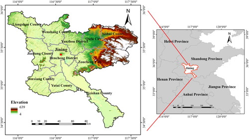
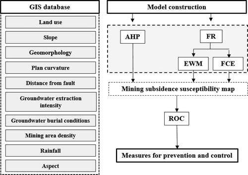
Figure 2. Mining subsidence workflow.
2.2. Data set
This study conducted a point density analysis using GIS for the location of mining area points, generated a density map of the mining area, and divided them into five categories through the natural breakpoint method. The classification method for groundwater exploitation intensity is to divide the ratio of local groundwater exploitation output to recharge resources into three levels using the natural breakpoint method. The distance from the fault is processed using GIS as a buffer. Slope and curvature are generated using GIS from raw DEM data. Other factor data are simply processed to meet subsequent requirements. The data sources are shown in .
Table 1. Data source.
3. Methodology
3.1. Workflow
This study can generally be divided into three steps ():
Step 1: The relevant factors used in this study were selected and a database was established to process the factors in GIS. Divide the 51 mining subsidence points into 35 and 16 parts. 35 points are used to get FR values. 16 points are used for model validation.
Step 2: AHP, FR-EWM, FR-FCE were used to obtain the mining subsidence susceptibility map, and the quantile method was used for zoning and comparing susceptibility areas.
Step 3: Based on the three mining subsidence susceptibility map, the values of the remaining 16 points were extracted and compared to the values possessed by the 16 randomly generated points. Produce ROC curves, select the optimal model, and give prevention, control and management measures from the previous conclusions.
3.2. Factor determination
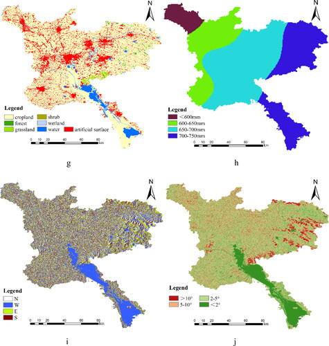
This paper have established a factor system for the field of mining subsidence. The causes of mining subsidence are the result of a combination of multiple factors but are most strongly affected by topography, geological structure, hydrology, and human activities. Therefore, having select factors from these four aspects next will explain the parameters selected. The results of each factor chart are shown in .
Figure 3. Factors: (a) topography; (b) groundwater extraction intensity (c) groundwater burial conditions (d) distance from fault (e) mining area density (f) Plan curvature; (g) land use; (h) Rainfall; (i) aspect; (j) slope.
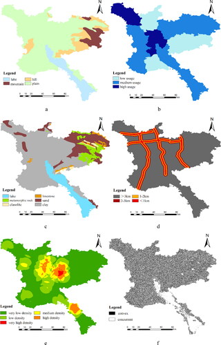
3.2.1. Groundwater extraction intensity
From the perspective of hydrogeology, land subsidence will be affected by groundwater exploitation. The larger the groundwater mining output is, the significantly lower the pore water pressure and the increase of effective stress will easily lead to plastic deformation and subsidence (Cigna and Tapete Citation2021).
3.2.2. Groundwater burial conditions
From a hydrogeological perspective, groundwater can provide certain support and stability, helping to resist the deformation and subsidence of soil layers under external pressure. The probability of land subsidence varies with different lithology, and sedimentary rocks are more prone to land subsidence than other lithology (Stanley and Clemente Citation2014). Generally speaking, sedimentary rock has high water content and moisture content, and soil is prone to rheology and deformation under load.
3.2.3. Mining area density
The greater the density of the mining area, the denser the underground mined out areas, and the more cavities in the underground space, resulting in the inability of the ground to be supported, increasing the probability of mining subsidence.
3.2.4. Land use
Land use is the main human factor affecting land subsidence, and different land use types have different probabilities of being affected by land subsidence (Chaussard et al. Citation2014). For example, buildings and other structures can change the coverage of land surfaces and increase ground loads. These activities may lead to soil shrinkage, thereby exacerbating land subsidence. In cropland, groundwater is used for water supply or irrigation. When water is improperly extracted or used, the groundwater level may decrease, leading to soil loosening and ultimately land subsidence.
3.2.5. Topography
The occurrence of land subsidence can be affected by different topographic conditions. Areas where rivers and lakes are located are more prone to land subsidence because water can wash, erode, and deposit underground rock and soil, causing land subsidence. Plains, mountains, plateaus, and hills: These landforms are relatively stable, and the possibility of land subsidence is small.
3.2.6. Slope
The larger slope increases the speed and impact of water flow, which may lead to soil erosion and even trigger hazard such as mudslides. This will cause the soil texture on the ground to deteriorate, thereby increasing the possibility of ground subsidence. Different slopes represent different effects of gravity, and steep slopes have poorer stability compared to flat surfaces (Arca et al. Citation2018).
3.2.7. Plan curvature
Curvature is the angle of the slope and is influenced by natural factors such as light, precipitation, and wind, which can affect subsidence (Yusof and Pradhan Citation2014). On surfaces with smaller curvature, water can more easily penetrate into the soil, forming a stable soil layer at the bottom. This helps to reduce the risk of land subsidence.
3.2.8. Distance from fault
The reason for the occurrence of faults is that the rock stratum is fractured due to the stress reaching a certain strength, and the rock stratum near the fault is relatively broken, which has a significant impact on land subsidence (Xie et al. Citation2022).
3.2.9. Rainfall
Rainfall will increase the amount of water in the soil and rocks, weaken the internal friction and cohesion of the soil, and make the ground less stable. Heavy rainfall may cause violent scouring by water flow, leading to soil erosion and the creation of subsurface cavities, as well as changes in groundwater levels, breaking the otherwise balanced solid-liquid-gas mechanical equilibrium system, increase the risk of subsidence.
3.2.10. Aspect
Aspect orientation affects the form of gravitational action, which has a direct impact on the stability of the slope. It also affects the distribution of water, which may collect more easily down certain aspect, increasing the saturation of the soil and thus reducing its stability. It can also have an impact on the degree of soil erosion, making it easier for water to scour the soil, weakening the stability of the slope and increasing the risk of subsidence.
3.3. Model processing
This study used the knowledge-driven method and the data-driven method to get the mining subsidence susceptibility map. The knowledge-driven method relies on domain knowledge and experience to guide it. It is a highly subjective process. A data-driven method is completely different from a knowledge-driven method. It is an objective process that relies entirely on available data for analysis based on domain knowledge
Knowledge-driven method: According to the geological environment and hazard mechanism of the study area, the classification under each index factor is scored artificially. The weights are obtained by using AHP. By superimposing the factors, the mining subsidence susceptibility map can be obtained.
Data-driven method:
Most of mining subsidence occurred in different classifications under each factors. 35 subsidence points were selected and their FRs were calculated using the knowledge-driven method classification. We then reassigned new values to each classification based on the FR values. The values of the 35 points under the new classification were extracted and then the weights of the different factors were obtained by FCE and EWM. Then superimposed these factors to get a mining subsidence susceptibility map.
3.3.1. FR
FR model is a statistical and commonly used approach for the preparation of mine subsidence mapping, and the mathematical representation of the FR model is as follows:
(1)
(1)
Where: x means factor for evaluating mining subsidence, is the number of mining subsidence in the
class of factor
is the total number of mining subsidence,
is the area in the
class of factor
and
is the total area of the study area.
3.3.2. AHP
The Analytic Hierarchy Process (AHP) is a decision-making tool that can be applied to mining subsidence mapping. AHP is a multi-criteria decision analysis method that can help prioritize and evaluate different factors and criteria that are important in subsidence mapping. The main steps of AHP methods include criteria identification, pairwise comparisions and weight calculation. Consistency Ratio (CR) is a measure used in the AHP to determine the consistency of pairwise comparisons made by the decision-maker. The CR provides an indication of how well the decision-maker has performed the pairwise comparisons and whether the results can be considered reliable. The calculation of CR is as follows:
Where: is the consistency index, and
is a random index ().
Table 2. RI values for the pairwise comparisons in AHP analysis.
Where: is the maximum eigenvalue, and
is the total number of parameters
The calculation of AHP is achieved through Yaahp software.
3.3.3. Entropy weight method
EWM is a multi-criteria decision analysis method that can help prioritize and evaluate different factors and criteria that are important in subsidence mapping. It is based on the concept of entropy, which is a measure of the degree of disorder or uncertainty in a system. In this study, entropy can be used to determine the weight or importance of each criterion based on the degree of diversity in the data. The steps of the EWM method include criteria identification, data normalization, entropy calculation and weight calculation. The calculation of entropy is as follows:
Where: is the normalized value of the
factor, and
is the weight of
factor.
3.3.4. Fuzzy comprehensive evaluation method
The Fuzzy Comprehensive Evaluation (FCE) method is a decision-making tool that can be used to evaluate and prioritize different options for mining subsidence management. The FCE method is particularly useful in situations where the criteria for decision-making are uncertain or subjective. It is based on the concept of fuzzy logic, which is a mathematical framework that allows for reasoning with uncertain or incomplete information. The main steps for the use of the FCE method include factor identification, fuzzy sets defination, membership function caluclation and weight determination. In this study, we assume the initial weight of different factors is 1.
4. Result and discussion
4.1. Model weights
In this study, a total of 10 condition factors were selected, including geomorphology, slope, plane curvature, distance from the fault, groundwater extraction intensity, groundwater burial conditions, mining area density, rainfall, aspect and land use AHP, FR entropy evaluation method and FR fuzzy comprehensive evaluation method were used to evaluate each factor by combining subjective analysis with objective analysis. The FR method can quantitatively evaluate the relationship between the occurrence rate of subsidence and relevant factors by combining spatial data. The FR value represents the correlation degree between the factors and the occurrence of mining subsidence. For the two condition factors of mining area density and groundwater extraction intensity, the natural breakpoint method is used to divide them into five levels and three levels, because the natural breakpoint method is applicable to the situation where the data has jumped significantly ().
Table 3. The matrix of AHP.
shows the FR values of the factors leading to subsidence obtained from 35 subsidence points. As shown in the table, the greater the density of the mining area, the higher the correlation of the mining subsidence occurrence, showing a very obvious positive correlation. The mining area density is divided into five grades of I-V from large to small, and the FR values are divided into 5.37, 4.3, 3.38, 1.57 and 0.17. It can be very intuitive to see that the mining subsidence is due to the impact of mining activities. Geomorphology factors have a relatively obvious impact on mining subsidence. Geomorphology in the study area is divided into four types, but mining subsidence mainly occurs in plain and lake areas, with FR values of 1.16 and 1.69, respectively. The main reason is that the plain and lake occupy most of the surface area in the study area, and the mining area is concentrated here. Slope, aspect and plane curvature are intuitive physical characteristics of the terrain. In terms of slope, 0–2°, 2–5° and 5–10° show 0.89, 0.8 and 1.28 results, indicating that mining subsidence is more likely to occur in the interval with a slope of 5–10°, but no one occurs when the slope is greater than 10°. The plane curvature is strictly divided into two categories, because there is no point with curvature equal to 0 in the generated curvature grid, and the FR value is approximately 1.03 and 0.97. Aspect is divided into four types: north, south, west and east, and the FR values are 1.31, 0.5, 1.47 and 0.8, with the largest FR value in the north and west direction. The general direction of surface water flow in Jining is from northwest to southeast. The aspect is opposite to the surface water flow direction, the ground is more susceptible to water flow, which can cause soil erosion and subsidence. Rainfall is divided into four levels, (<600 mm), (600–650 mm), (650–700 mm) (700–750 mm). The continuous FR results are 0.43, 0.67, 1.16 and 1.12. The FR results differ significantly, indicating that the higher the rainfall, the more likely subsidence is to occur.
Table 4. FR values of each factor.
The characteristics of groundwater is one of the most important characteristics in the study of land supervision, because the increase of the exploitation intensity of groundwater and the influence of its occurrence conditions will lead to the consolidation and compression of the stratum, thus causing subsidence. The groundwater extraction intensity is divided into three levels, with FR values of 1.39, 1.02 and 0.7 respectively, showing an obvious positive correlation. According to local conditions, groundwater burial conditions can be divided into six categories: lacustrine deposit, limestone, metamorphic rock, sand, clasolite and clay. However, only lacustrine deposit, sand and clay have FR values of 2.19, 0.33 and 1.12, respectively. The main reason is that when the clay is under pressure, due to the exploitation of deep groundwater, the pore water pressure is significantly reduced, the effective stress is increased, plastic deformation is easy to occur, and subsidence occurs. Due to the pressure exerted by water bodies on lacustrine deposits, loose sediments are compressed and subsidence can also occur. The fault is a geological crack in the rock mass, which is extremely important for the study of mining subsidence. The distance from the fault is divided into four levels, (<1 km), (1–2 km), (2–3 km) (>3 km). The continuous FR results are 1.71, 1.75, 0.45 and 0.92, respectively. It can be seen that mining subsidence mostly occurs in the close range of 0–2 km, and the geological body around the fault is relatively unstable, which is one of the important reasons for the subsidence. Land use shows that the FR values of wetland, artificial surface, water body and farmland are 4.15, 1.68, 1.09 and 0.8 respectively. Wetlands occupy a small area, but subsidence occurs more frequently and has the highest FR. We believe that the reason is that the wetland catchment area has a large amount of sediment due to soil erosion, and the soil is relatively loose.
The weights obtained by AHP, EWM, and FCE method are shown in . It can be seen that the results obtained by the three methods take mining area density as the most important factor affecting the mining subsidence susceptibility, with weights of 0.3343, 0.3582, and 0.2 respectively. However, the next subjective priority of AHP is the groundwater extraction intensity (0.1972), Land use (0.1629), the lowest is the aspect (0.0157). EWM takes more account of land use (0.2286), groundwater burial conditions (0.1525) and distance from fault (0.0989), and ignores the impact of plane curvature (0.0009). According to the weight obtained by FCE, except for mining area density, the overall change is small, and more attention is paid to the influence of groundwater burial conditions (0.11) and geomorphology (0.1). EWM can reduce the impact of human factors, and determine the weight of factors according to the impact of the relative change of factors on the overall system. FCE can take the best evaluation factor value as the benchmark, and the rest of the less excellent evaluation factors can get the corresponding evaluation value according to the degree of the less excellent. So the fluctuation of the weights obtained from the FCE is very little. Compared with EWM, the importance of each factor cannot be well portrayed. Combining the three methods, it can be seen that the density of the mining area, land use, and groundwater burial conditions are the most important index factors that affect the mining subsidence susceptibility map.
Table 5. Weights for the three methods.
4.2. Mining subsidence susceptibility mapping
The susceptibility zoning map of mining subsidence obtained by AHP, FR-FCE and FR-EWM methods is shown as . The susceptibility zoning is divided into I-V levels by the quartile method, which are much higher susceptibility area, higher susceptibility area, medium susceptibility area, less susceptibility area and much less susceptibility area. As a level I subsidence event, the mining subsidence is concentrated in the central part of the study area, near the urban center of Jining City. The mining subsidence in Weishan County is also classified as a level I subsidence event. The comprehensive consideration should be mining area density in the central area is high, and the groundwater is overexploited, and human activities are relatively strong, resulting in a much higher regional susceptibility. Mining activities in Weishan County are influenced by the lake, and while mining activities result in a lack of support in the subsurface space, the lacustrine deposit is affected by the self-weight of the water area and the flow of water, and the original stress balance environment is substantially disrupted.
Figure 4. Three mining subsidence susceptibility mapping.
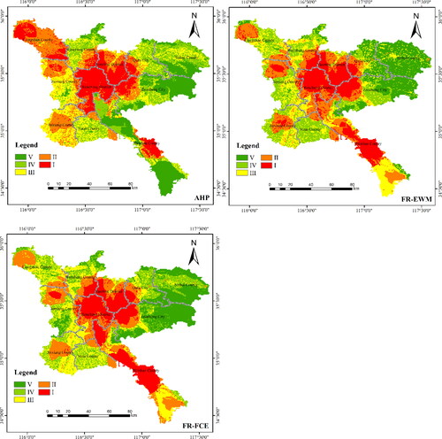
The differences reflected by the three methods are concentrated in Liangshan County and the central and northern regions of Weishan County. In the result chart obtained by AHP, Liangshan County is at the level I or II, but not in the results of FR-FCE and FR-EWM. It is mainly at level III and IV. It is speculated that in AHP, groundwater extraction intensity is more important, and the weight given to this factor is greater than the other two methods, this is the result of a knowledge-driven model. In the central and northern regions of Weishan County, the AHP results are distributed in the form of III–V, mainly with medium and much less susceptibility, while the results of FR-FEC and FR-EWM tend to be I–III. The results obtained by the two methods FR-FCE and FR-EWM do not differ much because the two methods are completely data-driven method, the difference between them only exists with the difference in the formulas for the calculation of the FCE and EWM weights, but the results and purpose of their multi-criteria decision analysis are the same.
4.3. Model comparison
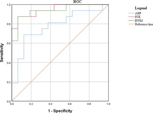
Receiver operating characteristic curve (ROC) can help us to evaluate the performance of the models and to compare them with each other. The area under the ROC curve is called Area Under Curve (AUC), and the value ranges from 0.5 to 1. The closer the value is to 1, the better the model is, and the AUC is an important tool to compare the performance of different models.
In order to verify the model, the study divided all the 51 mining subsidence points that have occurred into 35 points and 16 points. 35 points have been used to obtain FR values before, and 16 points have been used for ROC verification with randomly generated 16 points. As shown in , the AUC of AHP, FR-EWM and FR-FCE are 0.777, 0.938 and 0.949 respectively. The results obtained show that the efficiency of FR-EWM and FR-FCE in this study is much higher than that of AHP. The sensitivity of the AHP model can be changed by changing the weight of the factor, but even in the analysis involving human factors, the accuracy of the AHP that relies on expert scoring and artificial differentiation of correlation to obtain the weight is poor. The method obtained from FR-EWM and FR-FCE is more accurate and has different emphasis, which is suitable for susceptibility evaluation in general areas. As mentioned above, the weights of FCE portray each factor worse than EWM, which is the main reason why the AUC of FR-FCE is lower than that of FR-EWM. In future work, the comparison and consideration of multiple methods should be carried out for model selection. The subjective evaluation can be carried out in the selection and classification of index factors, but the model should be established by making full use of the known data and being familiar with the local geological environment and human activities.
Figure 5. ROC curve of AHP\EWM\FCE.
4.4. Measures for prevention and control
There are many hazards caused by mining subsidence. Not only is the land face and ecological environment severely damaged, but also the sustainable development of the economy and society is greatly restricted. It will also lead to the rapid reduction of cropland land, a serious threat to the production and livelihood of the people in the mining area, and will also cause a series of social problems, increase the unstable factors, and cause a large number of farmers to lose the land they rely on for survival.
In the research system established, mining area density, land use, and groundwater burial conditions are the most important index factors affecting mining subsidence. So we have decided to start from these three factors to propose some reasonable prevention and control measures for mining subsidence in Jining City.
The amount and density of mining area density is the most important factor influencing the occurrence of mining subsidence, but mining is inextricably linked to local government revenues and economic development. When mining activities must be carried out, preventive measures should be taken before mining, techniques and measures should be adopted to reduce subsidence, and to reduce the infiltration of surface water. Attention should be paid to dredging surface drainage ditches before the rainy season and strengthening monitoring during the rainfall season, as well as waterproofing surface water and underground drainage systems.
Land use and development should be planned in an appropriate layout. The use of artificial surface must be avoided in the mining area to prevent the upper load from increasing, which will break the fragile mechanical equilibrium system and cause subsidence. After mining, according to the information on coal mine-out areas, the scale of mining should be divided into small, medium and large, and the impact area of the surface should be calculated and circled for post-mining treatment. At present, China has taken many measures to deal with abandoned mines, such as making abandoned mines into mine parks, which combine commercial value with environmental value as a good guide.
The loss of rock support due to mining-generated cavities is only one of the reasons why the mining subsidence occurred. From the analysis of the mechanism of subsidence, it is due to the decrease of pore water pressure, the increase of effective stress, and the occurrence of water-release compacting of loose sediments leading to the generation of subsidence. The ground subsidence caused by sand layer compaction is little, and it is elastic water release compaction, and the ground springs back when the pore water pressure is restored. In the case of plastic water-release compacting in clay layer, the ground will not rebound even when the groundwater level is restored, resulting in irrecoverable ground subsidence. Therefore, the burial conditions and mining intensity of groundwater should be controlled to minimize the intensity of groundwater mining, and the burial conditions of groundwater should be analyzed before mining.
5. Conclusion
This study discussed the susceptibility of mining subsidence in Jining area, selected ten important geological environmental factors, using FR and expert experience to manage factors. And the weights were obtained through AHP, EWM and FCE methods. From the results, it can be seen that the mining area density, land use, and groundwater burial conditions are the most important index factors affecting mining subsidence susceptibility. Combined with AHP, FR-EWM and FR-FCE methods, the mining subsidence susceptibility zoning map is obtained. It is divided into I-V levels by the quartile method, which are much higher susceptibility area, higher susceptibility area, medium susceptibility area, less susceptibility area and much less susceptibility area. It is concluded that the mining subsidence is in the middle of the study area, that is, in the urban area of Jining City and near Weishan County, which is level I susceptibility to occur. It is speculated that it is affected by mining area density and the destruction of surface water respectively, but the conclusions drawn by the three methods are also different, mainly reflected in Liangshan County, the central and northern parts of Weishan County and the northern areas of. The reason may be that AHP is affected by human factors, and the weight given to this factor is large, it is cause by a knowledge-driven model. EWM can better reduce the impact of human factors and give a relatively objective weight. In the validation, 51 points in the mining subsidence area were used, which were divided into a total of 35 points and 16 points. 35 points were used to obtain FR values before, and 16 points were used for ROC validation. The AUC of AHP, FR-EWM and FR-FCE were 0.777, 0.938 and 0.949. The efficiency of EWM and FCE in this study was much higher than that of AHP. This means that the accuracy of data-driven models is much higher than that of knowledge-driven models. The results of ROC show the importance of model selection and comparison among multiple methods, and we should make full use of known data to build the model with objective and human participation.
Through the established research system, the three most important index factors affecting mining subsidence are addressed to the mining area density, land use and groundwater burial conditions. Some reasonable prevention and control measures are proposed to Jining mining subsidence. The prevention and control measures should be carried out according to local conditions, and the occurrence of mining subsidence should be avoided through preventive measures before mining and treatment after mining. (1) prevention should be carried out during mining activities to reduce the infiltration of surface water, and timely trapping and drainage in the rainy season, (2) reasonable use of land planning to avoid the construction of artificial surface in the mining area, and the scale of the existing mining area should be classified and treated separately (3) analysis of groundwater burial conditions before mining, reasonable extraction of groundwater, and prevention from the mechanism of subsidence creation. This article compares knowledge-driven models with data-driven models, establishes an effective evaluation system, adopts concise and effective methods to predict the susceptibility of mining subsidence using information easily available from various aspects, obtains accurate model validation results, proves the reliability of data-driven models, and provides a good reference for land use planners, engineers, and government agencies in land planning and sustainable development. Finally, despite the good results obtained from this study, it has some limitations: (1) This knowledge-driven model is applicable to large areas of the plain and does not provide a good description of subsurface human activity on a large scale. (2) In areas with extensive special geological formations, relevant engineering geological indicators need to be added to complement the model. (3) The model is also cumbersome to compute and generate results when the amount of data is too high, and cannot be continuously learned and improved like machine learning models.
Acknowledgements
The author thanks the Project of Urban Geological Survey of Jining City for its support.
Disclosure statement
No conflict of interest exits in the submission of this manuscript, and the manuscript is approved by all authors for publication. I would like to declare on behalf of my co-authors that the work described was original research that has not been published previously, and not under consideration for publication elsewhere, in whole or in part. All the authors listed have approved the manuscript that is enclosed.
Data availability statement
The authors do not have permission to share data.
References
- Alaee NH, Mozafari A, Mirzaee M, Faghihi A, Tolouei K. 2019. Fuzzy evaluation method for the identification of subsidence susceptibility in an underground mine (case study in Tabas coal mine of Iran). Nat Hazards. 99(2):797–806. doi: 10.1007/s11069-019-03774-2.
- Arca D, Kutoğlu HŞ, Becek K. 2018. Landslide susceptibility mapping in an area of underground mining using the multicriteria decision analysis method. Environ Monit Assess. 190(12):725. doi: 10.1007/s10661-018-7085-5.
- Chang M, Dou XY, Tang LL, Xu HZ. 2022. Risk assessment of multi-disaster in mining area of Guizhou, China. Int J Disaster Risk Reduct. 78:103128. doi: 10.1016/j.ijdrr.2022.103128.
- Chaussard E, Wdowinski S, Cabral-Cano E, Amelung F. 2014. Land subsidence in central Mexico detected by ALOS InSAR time-series. Remote Sens Environ. 140:94–106. doi: 10.1016/j.rse.2013.08.038.
- Choi JK, Kim KD, Lee S, Won JS. 2010. Application of a fuzzy operator to susceptibility estimations of coal mine subsidence in Taebaek city, Korea. Environ Earth Sci. 59(5):1009–1022. doi: 10.1007/s12665-009-0093-6.
- Cigna F, Tapete D. 2021. Satellite InSAR survey of structurally-controlled land subsidence due to groundwater exploitation in the Aguascalientes valley, Mexico. Remote Sens Environ. 254:112254. doi: 10.1016/j.rse.2020.112254.
- Dong SC, Samsonov S, Yin HW, Yao SP, Xu C. 2015. Spatio-temporal analysis of ground subsidence due to underground coal mining in Huainan coalfield, China. Environ Earth Sci. 73(9):5523–5534. doi: 10.1007/s12665-014-3806-4.
- Kim Y, Lee SS. 2020. Application of artificial neural networks in assessing mining subsidence risk. Appl Sci. 10(4):1302. doi: 10.3390/app10041302.
- Kowalski A, Bialek J, Rutkowski T. 2021. Caulking of goafs formed by cave-in mining and its impact on surface subsidence in hard coal mines. Arch Min Sci. 66(1):85–100.
- Lee S, Park I, Choi JK. 2012. Spatial prediction of ground subsidence susceptibility using an artificial neural network. Environ Manag. 49(2):347–358. doi: 10.1007/s00267-011-9766-5.
- Li WB, Fan XM, Huang FM, Chen W, Hong HY, Huang JS, Guo ZZ. 2020. Uncertainties analysis of collapse susceptibility prediction based on remote sensing and GIS: influences of different data-based models and connections between collapses and environmental factors. Remote Sens. 12(24):4134. doi: 10.3390/rs12244134.
- Malinowska AA, Misa R, Tajdus K. 2018. Geomechanical modeling of subsidence related strains causing earth fissures. Acta Geodyn et Geomater. 15(2):197–204. doi: 10.13168/AGG.2018.0015.
- Martinez-Moreno FJ, Galindo-Zaldivar J, Gonzalez-Castillo L, Azanon JM. 2016. Collapse susceptibility map in abandoned mining areas by microgravity survey: a case study in Candado hill (Malaga, Southern Spain). J Appl Geophys. 130:101–109. doi: 10.1016/j.jappgeo.2016.04.017.
- Mohammady M, Pourghasemi HR, Amiri M. 2019. Land subsidence susceptibility assessment using random forest machine learning algorithm. Environ Earth Sci. 78(16):1–12. doi: 10.1007/s12665-019-8518-3.
- Oh HJ, Lee S. 2010. Assessment of ground subsidence using GIS and the weights-of-evidence model. Eng Geol. 115(1–2):36–48. doi: 10.1016/j.enggeo.2010.06.015.
- Oh HJ, Syifa M, Lee CW, Lee S. 2019. Land subsidence susceptibility mapping using Bayesian, functional, and meta-ensemble machine learning models. Appl Sci. 9(6):1248. doi: 10.3390/app9061248.
- Santo A, Budetta P, Forte G, Marino E, Pignalosa A. 2017. Karst collapse susceptibility assessment: a case study on the Amalfi coast (Southern Italy). Geomorphology. 285:247–259. doi: 10.1016/j.geomorph.2017.02.012.
- Stanley JD, Clemente PL. 2014. Clay distributions, grain sizes, sediment thicknesses, and compaction rates to interpret subsidence in Egypt’s Northern Nile Delta. J Coast Res. 30(1):88–101.
- Su QM, Tao WH, Mei SG, Zhang XY, Li KX, Su XY, Guo JL, Yang YG. 2021. Landslide susceptibility zoning using c5.0 decision tree, random forest, support vector machine and comparison of their performance in a coal mine area. Front Earth Sci. 9:781472. doi: 10.3389/feart.2021.781472.
- Suh J, Choi Y, Park HD, Yoon SH, Go WR. 2013. Subsidence hazard assessment at the Samcheok Coalfield, South Korea: a case study using GIS. Environ Eng Geosci. 19(1):69–83. doi: 10.2113/gseegeosci.19.1.69.
- Tzampoglou P, Loupasakis C. 2017. Mining geohazards susceptibility and risk mapping: the case of the Amyntaio open-pit coal mine, west Macedonia, Greece. Environ Earth Sci. 76(15):1–16 doi: 10.1007/s12665-017-6866-4.
- Unlu T, Akcin H, Yilmaz O. 2013. An integrated approach for the prediction of subsidence for coal mining basins. Eng Geol. 166:186–203. doi: 10.1016/j.enggeo.2013.07.014.
- Wu ZY, Niu QH, Li WP, Lin NH, Liu SL. 2018. Ground stability evaluation of a coal-mining area: a case study of Yingshouyingzi mining area, China. J Geophys Eng. 15(5):2252–2265. doi: 10.1088/1742-2140/aac991.
- Xie YH, Zhang BH, Liu YX, Liu BC, Zhang CF, Lin YS. 2022. Evaluation of the karst collapse susceptibility of subgrade based on the AHP method of ArcGIS and prevention measures: a case study of the Quannan expressway, section k1379 + 300-k1471 + 920. Water. 14(9):1432. doi: 10.3390/w14091432.
- Yilmaz I. 2007. GIS based susceptibility mapping of karst depression in gypsum: a case study from Sivas basin (Turkey). Eng Geol. 90(1–2):89–103. doi: 10.1016/j.enggeo.2006.12.004.
- Yilmaz I, Marschalko M, Bednarik M. 2011. Gypsum collapse hazards and importance of hazard mapping. Carbonates Evaporites. 26(2):193–209. doi: 10.1007/s13146-011-0055-4.
- Yusof NM, Pradhan B. 2014. Landslide susceptibility mapping along PLUS expressways in Malaysia using probabilistic based model in GIS. 7th IGRSM International Remote Sensing and GIS Conference and Exhibition; Apr 21-23 2014; Kuala Lumpur, Malaysia.
- Zhang B, Zhang LZ, Yang HL, Zhang ZJ, Tao JL. 2016. Subsidence prediction and susceptibility zonation for collapse above goaf with thick alluvial cover: a case study of the Yongcheng coalfield, Henan province, China. Bull Eng Geol Environ. 75(3):1117–1132. doi: 10.1007/s10064-015-0834-6.