
Abstract
Spatial plan decisions guide both the future use of the lands and many activities from protection to construction and permit. Due to its functions, spatial plan decisions play a key role in land administration. Spatial planning information for integrated land administration systems (LASs) should be associated with land registration systems. The Land Administration Domain Model (LADM) standard offers components to enable this structure. Integrating spatial plan data with LASs will provide standardization for plan data and assurance of plan decisions. Although the spatial planning mission differs across various administrative regions, planning activities produce land use decisions, albeit in different ways. The study aims to establish the common points in planning activities and design a joint spatial planning system data model using various countries’ spatial planning systems and international standardization studies. The spatial plans in the model that has been proposed are depicted as a system, not merely by the rights, restrictions, and responsibilities (RRRs) that they establish on the land. The results point out that spatial planning systems have some similarities but also some limitations to support conceptual model design. Based on joint data and relationships, the proposed spatial planning system data model can be adapted for different country practices. The study’s results are expected to support the LADM second version development studies.
1. Introduction
Spatial planning is the process of determining projections in the light of a vision of future land use. Spatial plans produce and guide spatial decisions in many different domains, ranging from construction to transportation and environmental, natural, and cultural protection (Yılmaz and Alkan 2023). Land use rights, restrictions, and responsibilities (RRRs) for lands whose physical boundaries and legal status are defined by the cadastral procedure are decided based on spatial plans. Spatial planning is one of the functions of land administration and is closely related to other functions such as cadastre, land valuation, and land development (Enemark Citation2004). Spatial planning is linked to land registration, including decisions that create new land subdivisions and land use patterns (United Nations Citation2008). In addition, spatial planning activities cannot be carried out without land inventory and property information obtained through cadastre. Spatial planning initiates and directs many land development activities (Bydłosz et al. Citation2018).
Moreover, the urban environment created by spatial-land use plan decisions and zoning permits determines land value (Levkovich et al. Citation2018). During the process of spatial planning, information regarding the land is gathered from different disciplines, leading to decisions about land-based use (Carsjens and Ligtenberg Citation2007). It involves extensive data circulation, including analyses, corporate opinions, strategic documents, and sectoral policies.
The 2030 Agenda for Sustainable Development (United Nations Citation2015) indirectly calls for member countries to commit to using information technology to protect rights, improve livelihoods, and enhance land management, as well as ensuring the participation of all stakeholders in land management and spatial planning. While these goals can be achieved through integrated information systems, it is common for countries to manage their cadastre systems separately from spatial planning as a distinct mechanism (Oosterom et al. Citation2019). The reason for this may be that the systems are not created simultaneously or that they are prepared only for one purpose. The International Federation of Surveyors expresses the requested relationship between the systems (FIG) as follows: "Land use planning should be closely related to the cadastre as it involves consultation and mediation processes" (Oosterom et al. Citation2019). In addition, national or international missions require spatial plan data and processes to be presented in standard procedures that align with land registration systems to ensure interoperability. Improvements are needed in developing an effective way to correlate land registration information with spatial planning policies and ensure interoperability (Indrajit, Jaya, et al. Citation2019).
The Land Administration Domain Model (LADM) standard was developed to eliminate the negative effects on interoperability of designing Land Administration Systems (LAS) specifically for each country application. LADM has found extensive use by providing the opportunity for modernizing the systems of countries that already have LAS, and for producing a LAS in a standardized structure based on the model for countries that do not have LAS yet (Kalogianni et al. Citation2021). Although countries have different land management approaches, thanks to the framework offered by LADM, they can present land administration systems with common data models. The Integrated Geospatial Information Framework (IGIF) lists nine requirements and objectives that today’s land administration must meet (UN-GGIM Citation2019). Of these, reliable data upgradable and interoperable standardized systems are also goals of LADM.
The current version of LADM is insufficient for representing each land administration function. Furthermore, it is limited to representing RRRs by land tenure and registration (Indrajit, Jaya, et al. Citation2020). However, the model allows for providing data set elements from external sources based on information models in accordance with other standards for data sets that are not included in the core classes (C. Lemmen et al. Citation2011). Thus, the model can be modernized according to requirements. Thus, the model can be modernized according to needs, including spatial planning data.
Various countries and organizations have studied developing a standardized model for spatial planning systems or integrating spatial plans with land registration systems. Further, there are studies advocating for the integration of land registration systems with spatial plans for healthy land management and legal-physical model integration (Cheng et al. Citation2006), highlighting the necessity for land administration and planning data to be in the same format and emphasizing the importance of spatial plans for 3D cadastre (Aien et al. Citation2015). In Switzerland, an ongoing study named PLR (Public Law Restrictions) cadastre includes the restrictions created by spatial plans for integrating land registration and spatial plan data (Eidgenossenschaft and Svizzera Citation2015). The PLR cadastre in Switzerland aims to present and document these restrictions in a single information system with parcel information. However, only a few initiatives have turned these ideas into data standardization. One of these is the INSPIRE Land Use Data Specification. The aim is to create harmonized land use datasets that can be used across Europe regardless of national boundaries with the Land Use Theme. The study is conducted in Poland following INSPIRE directives (Bydłosz et al. Citation2018) and aimed to create a preliminary concept of a Unified Modelling Language (UML) schema that integrates 3D cadastre and spatial planning. In the study in question, the integration of the spatial plan data set with the cadastre data set was achieved through the representation of spatial plan objects in a 3D cadastre. The representation of land use types and areas that cannot be built upon was emphasized in the study. Another standardization study on this topic was conducted by Indrajit, van Loenen, et al. (Citation2020), focusing on the INSPIRE data theme and the spatial planning system in Indonesia. The publication outlining the development goals of the second version of LADM (Oosterom et al. Citation2019) also includes an overview of the spatial plans package presented in detail (Indrajit, van Loenen, et al. Citation2020). The model created was later applied to a municipal permit case in Indonesia (Indrajit et al. Citation2021) by implementing it to the LADM country profile, and its functionality was discussed. The study proposing the development of the LADM Spatial Planning Information package (Indrajit, van Loenen, et al. Citation2020) and the INSPIRE Planned Land Use data specification study provide data models for spatial planning decisions at different levels of detail but do not include associations between plans themselves and the strategic data that guide them.
Additionally, while the study (Indrajit, van Loenen, et al. Citation2020) developed the model based on the Indonesian planning system, INSPIRE followed a European-based approach. The Poland 3D Cadastre (Bydłosz et al. Citation2018) and PLR Cadastre (Eidgenossenschaft and Svizzera Citation2015) studies, on the other hand, do not focus on standardizing spatial planning data. The main goal of these studies and their implementation methods may vary, but they share a common goal of achieving the effectiveness of spatial planning decisions in land management. The data represented in these studies share many similarities in many respects. These similarities are due to the common points in spatial planning decisions and processes. However, the shared deficiency of the studies is that either the cadastral system and the spatial planning system are not considered together, or they are developed only based on country profiles. Also, another gap in the literature studies is that spatial plans are only considered from a decision-based perspective.
This study aims to propose a flexible and adaptable Spatial Planning System Data Model (SPSDM) that can represent spatial planning system data independently of country-specific implementation differences based on common points in different countries’ spatial planning systems and literature studies. There are two main goals determined in line with this motivation: 1) Specification of the data and associations required for representing joint processes and decisions in spatial planning systems in the data model. 2) Designing an adaptable SPSDM that covers not only spatial plan decisions but also strategic documents that affect decisions, inter-plan directions and plan features in the context of LADM second version development studies in line with the determined requires. The study is expected to provide a common framework for countries seeking to integrate spatial planning systems into their country profiles. Thus, the proposed model is expected to fill the common standardization gap regarding spatial plans in the literature by taking a holistic approach. This paper is organized as follows: The data sets, and methods used for data modelling are introduced in the next section. Thus, the requirements that the model should fulfill are determined. Then, the designed model is explained in the results section. The fourth section includes the model’s strengths and weaknesses in its application. Finally, the results are presented.
2. Methods and data sets
Standardization is a supportive and helpful process in designing and developing land-related information systems. The concept of standardization refers to pre-determined approaches for defining parcels, documents, parties, geodetic points, and many other topics that are objects and components of land administration (C. Lemmen et al. Citation2015). The purpose of standardization is not only limited to the uniform definition of data. In addition to this, there is a wide range of impact, such as determining the process flows of land administration, the abbreviations to be used for the data, identifying the authorities who will produce and regulate the data, and defining the characteristics of the base maps to be used. Standardization is the first step to ensuring national and international interoperability. The LADM standard has taken on the mission of achieving this goal in land administration.
The ISO 19152 LADM standard presents a conceptual schema for land administration (C. Lemmen, Citation2012). Therefore, classes associated with LADM need to be presented in a conceptual schema language. To create the data model conceptually, UML diagrams, which are known as the Unified Modelling Language standard, are used as in LADM (Tija Citation2012). Conceptual model design is a designer-specific mission, and the designer reflects description of the real world on the model through requirements. Multiple conceptual models can be created that serve the same purpose and function. The goal should be to design a conceptual data model that accurately reflects the entities and the associations between them. In order to achieve this goal, it would be helpful to create generalized classes instead of numerous classes and avoid complex associations. It will facilitate the implementation of the model.
The workflow () for developing the Spatial Planning System is based on the design research methodology, which is widely used and recognized as effective in many land administration and cadastral studies (Peffers et al. Citation2007; Çaǧdaş and Stubkjær 2011; Xu et al. Citation2022). According to this methodology, the design research process consists of defining the problem through a literature review, analysing datasets and associations, designing the model based on the analysis, and evaluating the design to test its ability to solve the problem.
Figure 1. Design research methodology for external package design.

During the research problem identification stage, the importance of spatial planning systems within land management systems was determined, and the gaps in the literature studies mentioned in the introduction section were identified. Then, the requirements that the model is expected to meet were identified. In the analysis phase of the design research methodology, an attempt is made to extract what is possible and feasible from the available data. The collected data is compared with the objectives of the design, and strategies for addressing design problems are identified. The study created data sets using the 2017 Land-use Planning Systems in OECD report (OECD Citation2017a), literature studies, and the examinations of sections 2.1, 2.2, and 2.3. The data from section 2.1 was used to provide data to represent the dynamics of spatial planning systems, while section 2.3 was used to establish associations between spatial planning activities. Section 2.2, is based on literature studies that identified the decisions that spatial plans can include, was used in designing UML classes, attributes, and values. A requirements table for the data and associations the model should include was created using the data obtained in the analysis step of the methodology (). In the design phase, a model is developed. The SPSDM is the product of the study and is designed by starting from the common points of the data obtained in the analysis phase. Finally, the representation of which data the model will include and how it will be represented has been demonstrated, followed by a discussion on use scenarios and requirements.
Table 7. Recurring data and associations in spatial planning systems.
2.1. Spatial planning as a system
According to the International Encyclopaedia of Human Geography (Huxley and Inch Citation2020), spatial planning involves preparing plans, maps, or diagrams showing where socio-spatial activities should take place, as well as planning initiatives for social, economic, and environmental change processes to achieve specific goals. Considering the current situation of a region, a vision for the region is created through spatial plans, and efforts are made to realize the vision through various means, usually using state power.
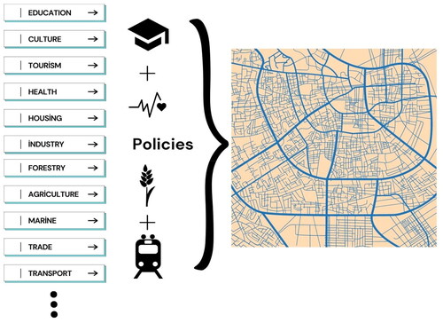
Spatial plans are the result of many independent policies. Decisions regarding the management of human and physical resources towards sectoral goals in agriculture, environment, energy, transportation, tourism, trade, etc. are components that make up spatial plan decisions (). Spatial plans are created to coordinate by integrating spatial policies related to different sectors. The relevant institution of the subject generally develops sectoral policies, which are used as inputs in spatial plans by the authorized institution responsible for planning.
Figure 2. Transformation of sectoral policies into spatial plan.
Spatial planning as a system evaluates planning activities through legal and procedural processes that establish the fundamental rules for planning implementation (Healey Citation2020). Essentially, the planning system provides a legal and regulatory framework for planning implementation. The effective implementation of spatial planning depends on developing relevant laws, policies, guidelines, procedures, and incentives (United Nations Citation2008). The sectoral plans that guide the establishment of spatial plan decisions and the legal bases that form the spatial plan framework should be included in the model to enable the representation of the spatial planning system. Also, the guidance of these documents on spatial plans should be presented with UML associations in a relational way.
In the planning system, the coordinated progression of planning from higher governance levels to lower governance levels is customary (OECD Citation2017b). This hierarchical spatial planning structure involves the creation of a framework for land use allocation and development at numerous governance levels, ranging from national to regional and local (Hall and Tewdwr-Jones Citation2019). This framework aims to coordinate and guide the use of land and resources in a manner that is consistent with broader social, economic, and environmental objectives. In the hierarchy of spatial planning, a lower-level spatial plan is implementing a higher-level plan for the same area. Typically, only one plan that covers a planning region is not prepared. Various spatial plans with different scopes and purposes covering the same region are created. The binding and directing relationship between these plans is defined within the planning system. One of the main objectives of the model to be designed is to represent not only the impact of spatial plans on the land but also their association with other spatial plans. In this way, it will be possible to monitor how high-level plan decisions are implemented at lower levels. In order to achieve this, it is necessary to transfer the association between spatial plans to the model.
2.2. Spatial plan decisions
Keeping a record of all RRRs of lands will assist in tenure security, investment planning, and smart city applications (Indrajit et al. Citation2021). In this regard, the necessity of identifying and standardizing every RRR that makes a difference in the land has emerged (Indrajit, Jaya et al. Citation2020; Indrajit, van Loenen, et al. Citation2020; C. Lemmen et al. Citation2019; Paasch et al. Citation2015). The current LADM country profiles deviate in terms of RRRs scopes depending on the jurisdictions, but they mainly represent rights and restrictions such as mortgages, easements, and rights of way that exist in countries’ cadastre systems (ISO 2012). In addition to the RRRs of the register system, various contracts, municipal council decisions, real estate valuation processes, land development practices, and spatial plans also create RRRs on the land (Indrajit, van Loenen, et al. Citation2020).
Spatial planning is a comprehensive process involving many actors, leading to economic, social, and cultural consequences. The impact of planning decisions is not limited to determining land use, but also affects natural resource conservation, environmental sustainability, climate change, social justice, cultural heritage, preservation, etc. While spatial plans represent the current land use type, land cover, and planned use of the land, they establish various RRRs in spaces for both the preservation of land use and access to the planned use. These RRRs can arise in determining the use function of land parcels, establishing construction requirements, and determining areas that will ensure a balance between conservation and use.
The volume of legal use that plans create in the area varies depending on the plan’s scope, the planning purpose, the level of planning and the strategies guiding the plan. Other important considerations include the spatial planning approach and legal framework of the administrative region in which the plan is located. Since these variables are specialized according to the country’s planning system, the common point for spatial planning decisions, regardless of their scope and level, is the types of land use and RRRs that the decision establishes. Spatial planning decisions need to be categorized to be presented in an adaptable conceptual model. Thus, the attributes of the model and the values corresponding to these attributes can be created. In order to determine the level of detail of the spatial plan decisions to be represented in the model, spatial plan decisions in literature studies were analysed (). The table categorizes spatial plan decisions as land use function type and special regulation decisions. Under the land use type category, planned land use function decisions established by spatial plans are presented, while under the special regulations category, spatial planning decisions that establish land use RRRs are presented. When the table is analysed, it is seen that land use function decision types are common in the categories of settlement type, workspace type, infrastructure type and natural impact area types. Special regulation spatial plan decisions are repeated in the categories of protection areas, limitation areas and development condition regulations.
Table 1. Spatial plan decision types in literature studies.
At the regional level, the INSPIRE Land Use Data Theme has focused on classifications related to land use types, in addition to which the RRR types related to the environment and land use that affect the land have been documented in the code lists under the SupplementaryRegulation attribute, which is under the SupplementaryRegulation class. INSPIRE is a unique resource for the development of models as it is based on European Union members and candidate countries. The other study listed in the table is the Swiss PLR Cadastre study. It is a study that integrates public law restrictions with LAS and it is stated that there are 150 types of PLR in the PLR cadastre (Besse Citation2021). Although not all of these PLR types originate from spatial plans, most of them are related to land use. The study focuses on the restrictions produced by spatial plan decisions rather than rights and responsibilities. The last planning decisions listed in the table are spatial planning functions identified in country models presented in individual studies conducted with national goals and standardization objectives (Bydłosz et al. Citation2018; Indrajit, van Loenen, et al. Citation2020; Yılmaz and Alkan Citation2022).
2.3. Spatial planning country practices
Spatial planning is a tool operated in many jurisdictions to manage the development and use of land (Douvere and Ehler Citation2009). Spatial planning systems vary from country to country, much like cadastral systems. Some countries use numerous spatial plans that contain strict decisions to guide land use and construction activities, while others use flexible and less spatial plans. Countries generally have plan-led or project-led spatial planning systems (Gielen and Tasan-Kok Citation2010). While plan-led spatial planning usually includes binding decisions on land use and development conditions are shaped by plan decisions, project-led plans are advisory plans that guide land use decisions and set a long-term vision and strategy for land use (Kilinc and Turk Citation2021). These differences converge in the basic logic of spatial plans, which is to produce land use decisions that refer to the physical space. The legal framework, types of plans, validity and scope of spatial plans that contain planning decisions can vary between countries and even between states within the same country, forming the spatial planning system.
Planning approaches are influenced by many factors, such as population density, landform, legal framework, and land ownership type. There is no standardized structure for spatial plans that every country needs and assigns different meanings to. In the land use systems report prepared by the OECD (OECD Citation2017a), planning systems are associated with differences in administration styles. The report outlines the objectives of the plans and their binding on each other.
In order to create a framework for SPSDM, countries were first grouped and examined according to their governance structures. Even in countries with the same group regarding governance structure, other factors still affect the planning system. When selecting the countries to be examined in this section, other criteria were considered, such as the countries being located in different geographical regions and having different population densities. It is assumed that countries located in different geographical regions will exhibit cultural differences in spatial planning. On the other hand, the differences in population densities are expected to manifest themselves in the form of strict or framework decisions in land use planning. Examining the spatial planning practices of countries would help to set data requirements such as the hierarchical relationship between plans the scope, type and purpose of plans in the data model to be designed. in the study includes country practices that represent the category well based on differences in planning systems due to administrative structure and population density. Additionally, country practices were used to ensure the unity of terminology, such as classes, attributes, associations, etc., of SPSDM.
Table 2. Germany spatial planning system specifications.
Table 3. Canada spatial planning system specifications.
Table 4. Turkey spatial planning system specifications.
Table 5. Japan spatial planning system specifications.
Table 6. England spatial planning system specifications.
2.3.1. Spatial planning system in federal administrations
In federal states, it is common for the central government to establish general framework provisions for planning, while the states determine their planning systems in their respective administrative regions. It is customary for the central government not to prepare any land use plans. Instead, the authority to determine land use decisions is delegated to the constituent states that make up the federal government. The planning system of the United States is the typical example of this approach. The national government has delegated the power to develop land use plans and framework legislation to the federated units. As a result, different planning approaches and a flexible hierarchy have emerged in the United States. In states with much land inventory and low population density, zoning plans or no land use regulation (City Mayors Citation2019) dominate, while detailed land use regulations are used in states with opposite characteristics.
Germany is a federal and densely populated country with 238 people per square kilometer, ranking 53rd according to World Bank data (The World Bank Citation2020). Given Germany’s high population density, it has a detailed planning hierarchy (). Germany consists of 16 administrative regions under the national government. Although planning is a shared task among all levels of government, the federal government does not create or implement plans (OECD Citation2017a). Instead, it establishes the general framework and policy structure to ensure regional and local planning consistency. The main planning authorities are states, regions, and municipalities (Schmidt and Buehler Citation2007). The federal government can enact spatial planning laws, but state governments can do so. If both levels of government accept spatial planning laws, the most recent law (federal or state) takes precedence (OECD Citation2017a). The German Constitution grants significant powers to municipalities regarding land-use decisions, and municipalities are responsible for preparing local land-use plans and other detailed urban planning tools in all states (OECD Citation2017a).
Belgium, which has another federal state structure, consists of 3 administrative regions and does not have a national spatial plan established at a level above the three regions. Spatial planning is completely delegated to the administrative regions, and some regions have their regional plans approved in their parliament, which include strategies and decisions related to public policies (Biot and Colard Citation2000). Belgium’s planning system is completed by the municipal structure and municipal implementation plans at the local level, which are guided by regional plans. However, the preparation of these local plans is left to the discretion of the municipalities. Another federal country which without a national plan is Canada. According to World Bank data, Canada is at the bottom in terms of population density (The World Bank Citation2020). The concentration of population density in some cities has led to the production of comprehensive plans at the local level in addition to the regional-scale strategic plans. Four types of plans are produced at the local level for development strategies, infrastructure, and permits ().
Based on the examples, it can be concluded that in countries with a federal governance system, while some central governments prefer to prepare just strategic plans, the majority do not take action in planning, and all planning activities are delegated to regional governments. The absence of a national directive leads to regional governments taking initiative, thus causing differences in planning systems within the country. However, this approach contributes to the planning understanding focused on regional needs.
2.3.2 Spatial planning system in unitary states
In a unitary state structure, the term "unitary" implies that a public institution cannot pursue policies that contradict or are inconsistent with the policies of other public institutions (Kunzmann Citation2016). Despite the increased autonomy and authority of local governments through forms of decentralization, central governments can intervene when deemed necessary. The principle of unity followed by the unitary system is also reflected in planning activities. While the national government sets planning goals, they are implemented by national and regional authorities at higher levels, and these higher-level policies affect local planning activities. In preparing local plans, local authorities take into account national objectives, and the central government may oversee this process through administrative supervision.
Turkey, a unitary state, has four main spatial plans in its spatial planning system. In spatial planning, the central government and local authorities work together. There is a National Spatial Strategy Plan, which can only be produced by the central government. This plan includes strategic and land use decisions. In addition, the central government determines the strategies and standards that local authorities must follow in their planning activities. Two of the four spatial plans are local plans, which are produced with the guidance of each other and strategic documents (). The central government can intervene in every stage of spatial planning. According to World Bank data, although it is not in the top ranks in terms of population density (World Bank Citation2020), the population is concentrated in certain areas in Turkey. A population-based criterion has been introduced for the preparation of local plans in the Turkish spatial planning system, and it is mandatory to prepare local plans in settlements with a population of more than 10,000.
In Japan, a strong orientation between spatial plans and hierarchy is well-developed in the Japanese planning system. Plans established at each level are reviewed and approved at several levels of administration. Japan’s spatial planning system’s complex structure and detailed planning decisions () can be attributed to its high population density.
In France, which has a unitary government structure, the central government is responsible for making framework decisions in planning and does not produce spatial plans at the national level, unlike Turkey and Japan. Decentralization has been strengthened in France since 1980 with the policies followed. Almost all planning functions were transferred to regional and municipal governments in 1982. Municipalities are responsible for land use planning and urban development. In addition, there are institutions that do not have planning authority but have planning authority for basic infrastructure such as roads. The spatial planning system in France has a hierarchical structure but is very flexible, and a lower-level plan does not have to follow a higher-level plan as long as it does not prevent the realization of the higher-level document. The plan, which is in the transition phase from the regional plan to the local level, is the SCoT (Urban Development Plan). It is created through inter-municipal partnerships, coordinating local plans and policies (Kunzmann Citation2016). These associations are responsible for creating strategic plans that provide a consistent strategy for cities. SCoTs are legally binding for local plans. The absence of any national plan and a flexible hierarchical spatial planning system distinguish France from other unitary country examples.
England, a part of the United Kingdom, is a different example of administration. With the increase of decentralization, the concept of national planning is losing its power in the United Kingdom, and this is also because the states that create regional plans have begun to see their regional plans as national plans (Kunzmann Citation2016). The National Planning Policy Framework (NPPF) is the strategic document developed for spatial planning in England (see ). Local land use plans are guided by metropolitan plans containing the main strategies. They present a vision for the future land use of a region regarding topics such as housing, environment, infrastructure, and transportation. In order to prepare neighborhood spatial plans, a neighborhood forum of citizens must be legally established. Neighborhood plans cannot restrict development in areas where the process approved by core strategies and local plans is taking place, but they can identify additional lands for development if it is in accordance with the NPPF (OECD Citation2017a).
3. Results
The final aim of the study is to propose an adaptive SPSDM structure that can be associated with LADM country profiles. In order to achieve this design, it is imperative to fulfill the first goal outlined in the study objectives. In this context, to determine the spatial planning data to be represented in SPSDM, spatial plans were analysed in the second section regarding the planning system, plan decisions, and country practices. Data repeated in different spatial planning systems and standardization studies () can be used as a data set to design a spatial planning system data model that can be adapted according to country practices. The proposed data model should be designed to represent the identified data and associations.
Based on the datasets reviewed in the second chapter and requirements (), a data model was designed to represent different spatial planning systems and support the extension objectives of the conceptual model of the LADM. In the design of the data model, UML diagrams were used for integration into the core classes of the LADM. In the UML, objects represent physical entities in the real world. During the conceptual modelling phase, detailed classes representing objects, attributes, values, names, and constraints are specified (Polat Citation2017). The data obtained through the examination of various spatial planning systems has been used in creating the class structure, attributes, and interclass association of the SPSDM. In order to allow flexibility for countries to adapt the data model according to their planning practices, the model has focused only on common processes and attributes, while non-common applications are included in the model under the ≪voidable≫ domain. The voidable stereotype is used when providing a value for certain properties is optional (European Commission Citation2013). Spatial plans are created on a specific location basis. Starting from this point, the SPSDM also consisted of planning object class in addition to the spatial plan data. SPS prefix is used as an abbreviation of the Spatial Planning System sentence for naming the data model classes.
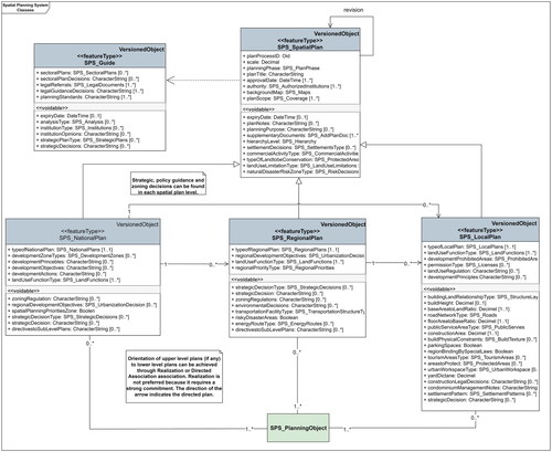
In the proposed data model, the SPS_SpatialPlan class is designed to contain joint properties for each spatial plan. The model proposes that common data such as scale, plan approval date, and plan transaction number that all spatial plans have should be represented in the SPS_SpatialPlan superclass. A new object class was created for each level spatial plan according to its levels. This representation can be used even when multiple plans are at the same administrative level. Based on the countries examined and OECD data, classes representing plan levels were formed as SPS_National, SPS_Regional, and SPS_Local. Each subclass created for the spatial plans in the plan level corresponds to the decision domain taken in the smallest polygon at the spatial plan location. The classes formed according to the levels have inherited their general properties from the SPS_SpatialPlan class with the UML generalization association.
Pre-established guidelines and legal documents are consulted to assign land use decisions. Guidelines and legal documents set the standards for the plan, the planning space, and the planning purpose. Also, population, threshold, disaster, etc., determine the types of land use analyses are also guiding. Sectoral plans and strategic directions form the starting point of spatial plans (see second chapter). Representing the effects in the background of the plan decisions in the data model contributes to the follow-up of the cause-effect relationship and the integrity between the processes. That’s why the SPS_Guide class was created to represent predetermined data (including non-spatial plans). The UML dependencies association provides the direct impact of these guidelines on spatial planning in the data model. This association states that a change from the SPS_Guide class will affect the SPS_SpatialPlan class and cause a change.
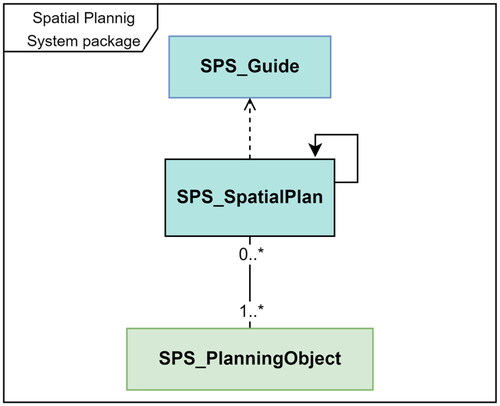
The space where the plan decision is taken corresponds to various land objects, and the plan decisions establish RRRs in these areas. Spatial plans are not typically created based on property boundaries. To establish the relationship between land parcels and spatial planning decisions, the SPS_PlanningObject class has been designed. The SPS_PlanningObject class is used to represent spatial objects affected by planning decisions. The association between plans and planning objects is designed in such a way that a land object can be influenced by zero or more (0.*) plans at the same level, and a spatial plan can contain decisions for one or more land objects (1.*). Through the SPS_PlanningObject class, it is expected that an association between planning decisions and the registered object class LA_BAUnit can be established. Thus, the proposed SPSDM is designed to consist of SPS_SpatialPlan, SPS_Guide, and SPS_PlanningObject classes (). With the classes designed with the generalization association from these classes, the model has gained the ability to represent the spatial plan hierarchy and the spatial objects affected by the plan.
Figure 3. Spatial planning system package overview.
The SPSDM has been designed based on a hierarchical planning system. Each planning level in the hierarchical planning system directs at least one spatial plan located below it. Binding guidelines or regulations are determined for the plans at lower levels. This hierarchical relationship between plans may vary from country to country (refer to ). In some countries, lower-level plans are given limited flexibility (as seen in examples like Turkey and Japan), while in others (such as France and the USA), they have more flexibility. Furthermore, the hierarchical categorization of spatial plans into national, regional, and local levels is absent in all countries’ planning systems. In some countries, spatial plans exist at each level, while in others like the USA, Canada, and Belgium, local plans are created directly without the need for higher-level plans.
Moreover, in some practices, the higher-level plan may not be binding for the lower-level plan. The representation and relationship between planning levels in the data model of the planning system are important for forming plan decisions. It is considered that the guidance between plans can be achieved adaptably according to country practices through directed association or realization UML associations in the model. The realization association is a special case of the generalization association. Unlike the generalization associations, the class being directed does not have to inherit all the structural characteristics of the directing class, but it inherits all the behavioural characteristics (ISO 2014). The directed association has been preferred as it provides a more flexible association between spatial plans, unlike the realization association, which creates a rigid binding. The direction in the relationship indicates the directed class. Through the directed association relationship, guidance and binding between spatial plans have been established, indicating the influence and connection of one plan to another.
The OECD reported that based on its survey conducted in 32 member countries, there are 229 different types of spatial and land use plans (OECD Citation2017b). According to the OECD's report on land use systems prepared for member countries, plans are categorized based on their geographic area. In addition to national, regional, and local plans, metropolitan, landscape, neighborhood, and other land use plans can be evaluated within these three main levels based on administrative boundaries. Metropolitan plans can be represented within the regional plan category, while landscape and neighborhood plans can be classified as local plans. A plan type attribute has been defined within the main-level plan classes at SPSDM to represent these plans. This helps to avoid creating additional classes to represent spatial plans outside the scope of national, regional, and local spatial plans. Indeed, it is common for countries to have multiple spatial plans at the same level. For instance, in the Slovak Republic, there are local land use and zoning plans at the local level. A 0.* association has been established between the spatial plan class and the planning object to represent multiple plans at the same level, allowing for flexibility in accommodating multiple plans within the same level.
The code lists in the SPSDM also vary according to countries’ planning processes. The process ensures adaptability to different spatial planning systems; country-specific code list values should be left to the practices of each country. This allows for customization and alignment of the model with the specific requirements and practices of each country’s spatial planning system. Particularly, the scope of spatial planning and the authorized planning bodies differ based on countries’ administrative structures and governance areas. Moreover, the constraints, permissions, and areas governed by specific legislation resulting from spatial planning also contain uniqueness. It should be noted that code lists are expandable classes based on needs. This flexibility allows countries to represent their specific practices within the model while representing their planning systems. This ensures that the design of entities, entity properties, and relationships between entities is appropriate in an adaptable spatial planning data model across different countries.
One of the main functions of spatial planning is to establish future land use. serves as a valuable resource for future land use types and special regulations created which establish land use RRRs. The table categorizes spatial plans, and attributes and values are designed in the data model. The study’s second objective is to propose a general framework data model compatible with LADM for spatial planning. In line with this objective, structures have been created to represent the data in the code lists instead of creating code lists that apply to all countries. In the light of achieving the study’s first objective, it is seen that the types of economic activities, development areas and special law areas are common plan decisions at each planning level (). However, there is no common point regarding the plan level at specifically in which they are used (refer to section 2.3). Considering the other data in , the attributes of joint land use decisions have been added to the SPS_SpatialPlan class. Thus, these attributes can be inherited and used in other spatial plan classes at the planning level. Other land use types are represented in subclasses based on spatial plan levels. Classes are designed to provide planning levels and associations as much as possible at the requirements and can be adapted to a variety of practices ().
Figure 4. Spatial planning system package UML classes and associations.
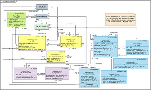
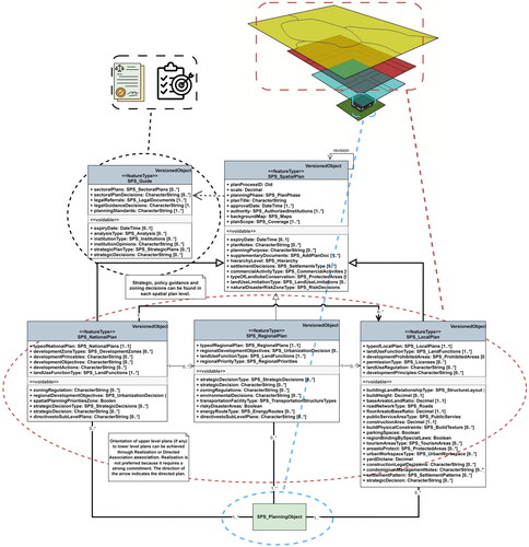
The fact that spatial plans are a function of LAS allows for the utilization of various classes from LADM in the design of SPSDM (). This approach helps to avoid the creation of new classes and provides usability. By establishing the association between the legal area formed by plan decisions and the LA_RRR (yellow packages) class, plan decisions are represented as RRRs. Establishing the association between the plan object and LA_SpatialUnit (blue packages) and LA_BAUnit (yellow packages) reflects the spatial impact of plans on the design. The relationship between the SPS_Guide and SPS_SpatialPlan (grey packages) classes with the LA_Party (green package) class has been established to represent the actors involved in planning using LADM core classes. The association of the SPS_Guide and SPS_SpatialPlan classes with the LA_AdministrativeSource (yellow package) and LA_SpatialSource (purple package) classes allows for the storage of cartographic plans and other documents in the LADM data structures.
Figure 5. Associating SPSDM and LADM classes.
4. Discussion and limitations
The proposed data model attempts to build a model based on the common aspects of spatial planning systems. In this context, the capability of the designed model was closely related to the identification of data sets that are frequently repeated in spatial planning system practices. The data and associations that can represent spatial plans as a system in the data model are derived from country practices and literature studies. Due to the selection of the data set, the SPSDM proposed in the study has benefited from the strengths of the standardization studies available in the literature. In addition to the gains from the literature, the model has been improved regarding coverage and functionality.
The model’s flexibility to be tailored to country-specific practices is crucial for its applicability. In this context, the starting point for the model design is the hierarchy, which is highly emphasized in country practices. Three plan-level classes have been created to represent the redirection relationship between spatial plans. The design allows countries without plans at a certain level to still represent their spatial plans using classes at other levels. Not using a dependent association type ensures this for the relationship between spatial plan classes. Another aspect that contributes to flexibility is the inclusion of voidable stereotypes and optional attributes in object classes in the design. According to the characteristics of plan levels, the attribute data they contain has been added to the classes in a basic manner, taking advantage of the plan objectives. The differences observed in the planning systems of countries have been designed in the classes below ≪voidable≫ stereotype.
The OECD has categorized spatial plans according to their function as policy guidance plans, strategic plans focused on achieving high-level objectives, and zoning/boundary plans that determine land use types in the most explicit manner (OECD Citation2017a). OECD states that strategic and zoning plans are generally prepared in a map-based format, but the clarity of boundaries may vary. Additionally, the OECD notes that plans with the three functions mentioned can be present at every level of the spatial planning system (OECD Citation2017a). In most cases, a spatial plan can fulfill multiple functions. According to an OECD survey (OECD Citation2016), 75% of national plans include policy guidance, 60% involve strategic decision-making, and 25% exhibit zoning/boundary plan characteristics. The ratio of zoning/boundary plan decisions for regional plans is 35%. Documents with the function of policy guidance, including sectoral and non-map-based strategic plans, are represented by the SPS_Guide class in the model. Other functions are met in the SPS_SpatialPlan class and their subclasses ().
Figure 6. Objects to which the proposed SPSDM classes correspond in the planning system (documents directing the generation of spatial plans are represented in the SPS_guide class, spatial plans are represented in the SPS_SpatialPlan class, and its subclasses, parcels, structures parcel blocks etc. are represented in the SPS_PlanningObject class).
Validity of plans is an important feature, especially for national plans. In some countries, the validity of national spatial or non-spatial plans is limited by the government’s term of office. Indonesia is one of these countries (MLIT Citation2017). The model adds the expiry date attribute in the SPS_Guide and SPS_SpatialPlan classes to meet this requirement. It allows for representing the validity period of plans within the model. Also, the VersionedObject class, which is part of the LADM, is used to manage changes in data over time. Like all core classes of LADM (ISO 2012), SPS_Guide and SPS_SpatialPlan classes were also created as subclasses of VersionedObject. It enables tracking of revised plans.
Consistency of terminology is critical to using a common data model for interoperability. In the proposed data model, class diagrams have been formed using joint concepts in both in-country applications and those recognized by the OECD. General expressions have been used in terms of attributes to provide flexibility. In this way, a common language and structure that can represent the spatial planning systems of different countries has been tried to be created. This conceptual coherence can facilitate interoperability and collaboration using the shared data model. Using OECD terminology in the proposed model class diagrams serves the study’s first objective, identifying common data.
The SPSDM does not exhibit complete coverage regarding attribute inclusion in representing the planning system. This is due to the diversity of planned land use types and specific country practices, even though the dataset was chosen to be comprehensive. General attribute types have been identified to address this issue, and the diversification has been reflected in the code lists. Countries presenting planning data in the SPSDM can add attributes or expand code lists while preserving the UML class structures.
According to statistics from OECD countries, 16 types of plans do not belong to national, regional, or local categories (OECD Citation2017a). These plans are specifically prepared for purposes such as coastal management, mining, and environmental protection. While these plans may sometimes have an impact within the hierarchy of the main land use plan, they generally have their hierarchy. The model cannot represent special purpose plans because their relevance to land use plans is not always the same.
Implementation of spatial plan decisions guides many land development activities. Establishing associations between the spatial plan class and the class that will include land development tools can enable the integration of the association between plans and their implementation into the model in future studies. These connectivity opportunities will allow tracking spatial plan transformation into land development practices. The separate representation of spatial plans in different classes based on their levels also serves this purpose. This design provides a more holistic approach to land administration, extending the model to other land administration functions (Enemark Citation2004) in future studies. This allows more processes that establish RRRs in the lands to be documented in a standardized way.
With dense urbanization, residential area ownership structures and land use levels are changing. The LADM considers the 3D representation of the resulting legal spaces (van Oosterom and Stoter Citation2010). LASs that enable the representation of 3D legal spaces can contribute to digital twin and smart city studies by integrating legal spaces with physical spaces. Spatial plans also contain important RRRs in the creation of three-dimensional legal spaces. The LADM conceptual model extended with spatial planning system data () allows a 3D representation of land use decisions.
The use of international standards is encouraged by many organizations as it facilitates the sharing of information and data between different countries and establishes a common language to enable effective communication and collaboration. The generated model is designed as an external package under the LADM standard. LADM country profiles are being developed by many countries (Alkan and Polat Citation2017; Govedarica et al. Citation2021; Shnaidman and van Oosterom Citation2019). This study serves as a guiding resource for countries seeking to integrate spatial planning systems into their country profiles. The presentation of the association of the proposed SPSDM with the LADM core classes demonstrates that it is possible to include spatial planning systems as an external package in the country profiles.
In national, regional, and international spatial planning standardization efforts, initiatives have addressed spatial planning data at different levels. Of these, INSPIRE's Planned Land Use Data Theme, emphasis has been placed on classifications related to land use types and special regulation zones. While the code lists represent land types where structures cannot be built, the model does not include building construction criteria. In the Swiss study (Eidgenossenschaft and Svizzera Citation2015), one of the national projects aiming to integrate public law restrictions with LAS, it has been stated that there are 150 types of PLRs. Spatial plan decisions are considered only as restrictions. The national UML design study conducted in Poland (Bydłosz et al. Citation2018) focused on 3D cadastre, and only local plan decisions were designed in the model. In the spatial plan data model study developed for the LADM edition II, a spatial planning package has been created by introducing external classes within LADM (Indrajit, van Loenen, et al. Citation2020). The study strongly focuses on directly representing the final product of spatial plans (decisions) rather than representing spatial plan elements (scale, authority, guidance documents) and the association between plans. The designed SPSDM aligns with other studies regarding its resulting product and relationship with LASs. However, it differs regarding the represented data and objectives (). The study uses a design that allows representation based on the hierarchy of spatial plans. This enables representing specific features and relationships brought by each plan level. The class of guidance documents (SPS_Guide) guides the production of spatial plans while allowing for the representation of non-spatial plans and plan directives. The association between polygonal plan decisions and land objects is established, enabling their relationship with cadastral objects. Thus, in this approach, the representation of all processes in spatial planning and decisions are made possible within the spatial planning system.
Table 8. Comparison of studies in the field of spatial planning data standardization.
5. Conclusion
This study deals with the design of a spatial planning system data model to contribute to the development of the LADM edition II. The main objective is to extend the conceptual model provided by the LADM standard with spatial planning system data. In this framework, the study follows the objectives of identifying the common points of spatial planning system practices and proposing an adaptable data model based on these points. In the analysed dataset, the planning levels of spatial planning systems, guidance documents, and spatial plan decision types were broadly similar, but their associations differed. Based on the recurring common spatial planning system characteristics, a flexible framework SPSDM was designed to represent different practices. As the proposed model is compatible with the LADM country profiles, it will encourage countries to present their spatial planning system data in a standardized structure.
Spatial planning can cause changes in property values through the decisions it generates, making it an important criterion in real estate valuation. Furthermore, many land development activities take place as a result of plan decisions. Creating SPSDM as an external package within LADM will allow its integration with other land administration functions. LADM provides a standard representing the legal boundaries of land administration objects. One of the goals of LADM edition II is to develop a coding standard between the legal and physical models (C. Lemmen et al. Citation2019). Considering that spatial plans create various legal RRR areas related to underground and aboveground land use, including the SPSDM in the LADM standard can allow for the establishment to provide land administration support to many smart city applications by enabling the matching of physical areas to legal boundaries.
Disclosure statement
No potential conflict of interest was reported by the authors.
References
- Aien A, Rajabifard A, Kalantari M, Shojaei D. 2015. Integrating legal and physical dimensions of urban environments. IJGI. 4(3):1442–1479. doi: 10.3390/ijgi4031442.
- Alkan M, Polat ZA. 2017. Design and development of LADM-based infrastructure for Turkey. Survey Review. 49(356):370–385. doi: 10.1080/00396265.2016.1180777.
- Bank TW. 2020. The World Bank: population density. https://data.worldbank.org/indicator/EN.POP.DNST?most_recent_value_desc=true.
- Besse M. 2021. The cadastre of public-law restrictions on landownership in Switzerland. In Smart surveyors for land and water management – challenges in a new reality.
- Biot V, Colard A. 2000. Challenges and issues of spatial planning in the European Union: European vision and supraregional co-operation. belgeo. 1-2-3–4(1-2-3-4):143–162. doi: 10.4000/belgeo.13962.
- Bydłosz J, Bieda A, Parzych P. 2018. The implementation of spatial planning objects in a 3D cadastral model. IJGI. 7(4):153. doi: 10.3390/ijgi7040153.
- Çağdaş V, Stubkjær E. 2011. Design research for cadastral systems. Comput Environ Urban Syst. 35(1):77–87. doi: 10.1016/j.compenvurbsys.2010.07.003.
- Carsjens GJ, Ligtenberg A. 2007. A GIS-based support tool for sustainable spatial planning in metropolitan areas. Landscape Urban Plann. 80(1-2):72–83. doi: 10.1016/j.landurbplan.2006.06.004.
- Cheng J, Turkstra J, Peng M, Du N, Ho P. 2006. Urban land administration and planning in China: opportunities and constraints of spatial data models. Land Use Policy. 23(4):604–616. doi: 10.1016/j.landusepol.2005.05.010.
- Douvere F, Ehler CN. 2009. New perspectives on sea use management: initial findings from European experience with marine spatial planning. J Environ Manage. 90(1):77–88. doi: 10.1016/j.jenvman.2008.07.004.
- Eidgenossenschaft S, Svizzera C. 2015. The cadastre of public-law restrictions on landownership (PLR-cadastre). https://www.swisstopo.admin.ch/en/knowledge-facts/swiss-cadastral-surveying/plr-cadastre.html.
- Enemark S. 2004. Building land information policies. UN, FIG, PC IDEA inter-regional special forum on the building of land information policies in the Americas.
- European Commission. 2013. INSPIRE infrastructure for spatial information in Europe D2.8.III.4 data specification on land use – technical guidelines. December.
- Gielen DM, Tasan-Kok T. 2010. Flexibility in planning and the consequences for public-value capturing in UK, Spain and the Netherlands. European Planning Studies. 18(7):1097–1131. doi: 10.1080/09654311003744191.
- Govedarica M, Radulović A, Sladić D. 2021. Designing and implementing a LADM-based cadastral information system in Serbia, Montenegro and Republic of Srpska. Land Use Policy. 109(June 2020):105732. doi: 10.1016/j.landusepol.2021.105732.
- Hall P, Tewdwr-Jones M. 2019. Urban and regional planning. New York: Routledge.
- Healey P. 2020. Collaborative planning: shaping places in fragmented societies. London: Bloomsbury Publishing.
- Huxley M, Inch A. 2020. International encyclopedia of human geography: urban planning. In: A. Kobayashi, editor. International encyclopedia of human geography. 2nd ed. Elsevier; p. 87–92. doi: 10.1016/B978-0-08-102295-5.10228-8.
- Indrajit A, Jaya VE, Loenen BV, Lemmen C, Oosterom PV, Ploeger H, Theodore R. 2020. The role of the revised land administration domain model and spatial data infrastructure in improving ease of doing business in Indonesia.
- Indrajit, Agung, van Loenen, Bastiaan, Jaya, Virgo Eresta, Ploeger, Hendrik, Lemmen, Christiaan, van Oosterom, Peter, Suprajaka,. (2021). Implementation of the spatial plan information package for improving ease of doing business in Indonesian cities. Land Use Policy, 105:105338. doi: 10.1016/j.landusepol.2021.105338.
- Indrajit A, van Loenen B, Ploeger H, van Oosterom P. 2020. Developing a spatial planning information package in ISO 19152 land administration domain model. Land Use Policy. 98(July 2019):104111. doi: 10.1016/j.landusepol.2019.104111.
- Indrajit A, Jaya VE, Loenen B v 2019. Implementation of spatial planning package for construction of an LADM country profile: reducing asymmetric access to information of RRRs in Indonesia. https://pure.tudelft.nl/portal/files/67728995/LADM2019_Paper_D3_F.pdf.
- ISO. 2012. ISO 19152 international standard geographic information—land administration domain model (LADM). Int Organ Standard. 2012:397.
- Kalogianni E, Janečka K, Kalantari M, Dimopoulou E, Bydłosz J, Radulović A, Vučić N, Sladić D, Govedarica M, Lemmen C, et al. 2021. Methodology for the development of LADM country profiles. Land Use Policy. 105(March):105380. doi: 10.1016/j.landusepol.2021.105380.
- Kilinc N, Turk SS. 2021. Plan changes in Istanbul (Turkey) as project-led practices in a plan-led planning system. Eur Plann Stud. 29(8):1393–1418. doi: 10.1080/09654313.2020.1865276.
- Kunzmann KR. 2016. Planning for states and nation-states in the US and Europe. disP Plann Rev. 52(3):121–124. doi: 10.1080/02513625.2016.1235903.
- Lemmen C. 2012. A Domain Model for Land Administration. Delft. NCG.
- Lemmen C, van Oosterom P, Bennett R. 2015. The land administration domain model. Land Use Policy. 49(September 2013):535–545. doi: 10.1016/j.landusepol.2015.01.014.
- Lemmen C, Van Oosterom P, Kara A, Kalogianni E, Shnaidman A, Indrajit A, Alattas A. 2019. The scope of LADM revision is shaping-up. Paper presented at 8th International FIG Workshop on the Land Administration Domain Model, October, p. 1–36.
- Lemmen C, van Oosterom PJM, Uitermark HT, Zevenbergen JA, Cooper AK. 2011. Interoperable domain models: the ISO land administration domain model LADM and its external classes. Int Arch Photogramm Remote Sens Spatial Inf Sci. XXXVIII-4/C21:31–40. doi: 10.5194/isprsarchives-XXXVIII-4-C21-31-2011.
- Levkovich O, Rouwendal J, Brugman L. 2018. Spatial planning and segmentation of the land market: the case of the Netherlands. Land Econ. 94(1):137–154. doi: 10.3368/le.94.1.137.
- Mayors C. 2019. Spatial planning and development in the USA: economic growth is of paramount importance. City Mayors. http://www.citymayors.com/development/usa-planning-development.html.
- MLIT. 2017. An overview of spatial policy in Asian and European countries. Ministry of Land Infrastructure, Transport and Tourism. https://www.mlit.go.jp/kokudokeikaku/international/spw/general/indonesia/index_e.html.
- OECD. 2016. Land-use governance survey. https://www.oecd.org/gov/governance-of-land-use.htm.
- OECD. 2017a. Land-use planning systems in the OECD country fact sheets. https://read.oecd-ilibrary.org/urban-rural-and-regional-development/land-use-planning-systems-in-the-oecd_9789264268579-en#page7.
- OECD. 2017b. The governance of land use in OECD countries policy analysis and recommendations. https://read.oecd-ilibrary.org/urban-rural-and-regional-development/the-governance-of-land-use-in-oecd-countries_9789264268609-en#page3.
- Oosterom PVAN, Kara A, Kalogianni E, Shnaidman A, Indrajit A, Alattas A, Lemmen C. 2019. Joint ISO/TC211 and OGC Revision of the LADM : valuation information, spatial planning information, SDG land indicators, refined survey model, links to BIM, support of LA processes, technical encodings, and much more on their way!. FIG Working Week 2019.
- Paasch JM, van Oosterom P, Lemmen C, Paulsson J. 2015. Further modelling of LADM’s rights, restrictions and responsibilities (RRRs). Land Use Policy. 49:680–689. doi: 10.1016/j.landusepol.2014.12.013.
- Peffers K, Tuunanen T, Rothenberger MA, Chatterjee S. 2007. A design science research methodology for information systems research. J Manage Inf Syst. 24(3):45–77. doi: 10.2753/MIS0742-1222240302.
- Polat ZA. 2017. Arazi̇ yöneti̇mi̇ni̇n tapu ve kadastro işlemleri̇ne yöneli̇k hari̇ci̇ veri̇ modeli̇ tasarimi ve uygulamasi [Yıldız Technical University, Institute of Science, PhD Thesis].
- Schmidt S, Buehler R. 2007. The planning process in the US and Germany: a comparative analysis. Int Plann Stud. 12(1):55–75. doi: 10.1080/13563470701346592.
- Shnaidman A, van Oosterom P. 2019. LADM-based Israeli country profile : toward implementation of 3D cadastre registration. Paper presented at 8th International FIG Workshop on the Land Administration Domain Model, October, p. 331–344.
- Tija D. 2012. Land administration domain model: application to the City of Johannesburg land information system, South Africa. GISSA Ukubuzana 2012: Academic paper.
- UN-GGIM. 2019. Framework for effective land administration. December. http://ggim.un.org/meetings/2018-Deqing-Expert-Group/documents/Concept_Note.pdf.
- United Nations. 2008. Spatial planning: key instrument for development and effective governance with special reference to countries in transition. Geneva: United Nations Economic Commission for Europe.
- United Nations. 2015. Transforming our world: the 2030 Agenda for Sustainable Development. United Nations General Assembly. doi: 10.1163/15718093-12341375.
- van Oosterom P, Stoter J. 2010. 5D data modelling: full integration of 2D/3D space, time and scale dimensions. In: Fabrikant SI, Reichenbacher T, van Kreveld M, Schlieder C, editors. Geographic Information Science (GIScience). Vol. 6292, (June). Berlin, Heidelberg: Springer; p. 310–324. doi: 10.1007/978-3-642-15300-6_22.
- Xu Z, Zhuo Y, Li G, Bennett RM, Liao R, Wu C, Wu Y. 2022. An LADM–based model to facilitate land tenure reform of rural homesteads in China. Land Use Policy. 120(June 2019):106271. doi: 10.1016/j.landusepol.2022.106271.
- Yılmaz O, Alkan M. 2022. Arazi idaresi temel modeli planlama paketi geliştirilmesi için Türkiye mekânsal planlama sisteminin incelenmesi. J Geod Geoinf. 9(2):150–165. doi: 10.9733/JGG.2022R0011.T.
- Yilmaz O, Alkan M. 2023. The joint spatial planning data model. Int Arch Photogramm Remote Sens Spatial Inf Sci. :387–390. doi: 10.5194/isprs-archives-XLVIII-4-W6-2022-387-2023.