
Abstract
Remote sensing models estimate chlorophyll concentrations by correlating spectral reflectance and reservoir chlorophyll. Different algal populations have different spectral signatures and thus different correlation models, an issue typically addressed by developing and applying a model using the same satellite image. Here we exploit these population differences by developing seasonal models that can be applied to other images from that season. We rely on algal succession and assume the phytoplankton population is relatively constant over a season, dividing the growth season into 3 parts as substitutes for population measurements. We present seasonal models developed using data from 2 Utah reservoirs, Deer Creek and Jordanelle, which have comprehensive long-term field datasets large enough to provide adequate near-coincident data for model development. We then apply the chlorophyll-estimation models to 5 reservoirs in north-central Utah and present the trends in the average, maximum, and variance of the chlorophyll concentration for each reservoir over a nearly 40-year period. We present examples of chlorophyll distribution maps that show spatial patterns and discuss implications for field sampling design and analysis. We found that season-specific models perform well for satellite images from the same season but do not perform well against images from other seasons. We suggest that these models can be used with confidence in the season for which they were developed, allowing analysis of historical data and providing current information on reservoir conditions without accompanying field samples.
Remote sensing is a useful tool for monitoring reservoir health, and even limited images can be used to develop more effective point sampling programs by identifying locations and times best suited for sampling (Gitelson et al. Citation2007). Remote sensing estimates chlorophyll concentrations by exploiting relationships between remotely measured reflectance and field-measured chlorophyll concentrations. Measured reflectance is a function of the optical properties of water such as absorbance and backscattering, which are influenced by phytoplankton communities (Gordon et al. Citation1988). Chlorophyll detection using satellites was initially applied to open ocean waters and used measured reflectance in the blue and green spectral regions (Gordon and Morel Citation1983) but was soon applied to inland lakes and reservoirs. Gitelson et al. (Citation2007) provide an extensive historical overview on model development for estimating chlorophyll in reservoirs and lakes with productive waters. Most of these models rely on the chlorophyll reflective peak found near 700 nm, with various modeling approaches using the ratios of 2 spectral bands on and off this peak to estimate chlorophyll concentrations (Gitelson Citation1992, Gitelson et al. Citation2007). These models rely on the assumption that the observable optical properties of chlorophyll are constant; however, these properties change with water properties (such as depth of the water column and level of suspended solids) and, important for the current study, the state and structure of the phytoplankton community. Water property changes, unless they affect the green spectral region where chlorophyll is visible, have less impact on prediction models, and models developed for a limited set of reservoirs have been applied across regions with varying water properties (Fuller et al. Citation2004, Wang et al. Citation2004, Olmanson et al. Citation2008, 2011). The dominant phytoplankton community can have a significant effect on optical properties because different phytoplankton communities demonstrate different relationships between chlorophyll concentration and reflectance measurements due to cell structure and other differences that make the chlorophyll more or less visible to the remote sensor, and they have different spectral properties due to cell pigment, size, and structure (Bricaud et al. Citation1995, Brando and Dekker Citation2003). Gitelson et al. (Citation2007) discussed more recent chlorophyll models that use additional channels and different model forms including combinations of band differences and ratios rather than just using spectral bands on and off the chlorophyll peak that address some of these issues.
Algal populations in temperate lakes and reservoirs follow a seasonal pattern of succession, with different populations dominating at different times (Stadelmann et al. Citation2001). Diatoms are generally dominant during colder spring conditions, with greens and then blue-greens dominating in warmer mid- and late-season conditions, respectively (Casterlin and Reynolds Citation1977). These different algal populations vary in pigment, composition, size, and structure, all of which affect the optical properties measured by remote sensing techniques (Bricaud et al. Citation1995, Sathyendranath et al. Citation2004). For example, diatoms have lower absorption coefficients for chlorophyll compared to other phytoplankton, most likely because the carbonate shell, with different spectral properties, is visible and shields much of the chlorophyll from observation. If an estimation algorithm developed using data from periods when other phytoplankton populations are dominant (e.g., greens or blue-greens) is used during diatom-dominant conditions, it may significantly underestimate concentrations (Bricaud et al. Citation1995, Sathyendranath et al. Citation1996, Stuart et al. Citation2000).
Remote sensing models for chlorophyll differ depending on the target phytoplankton communities (e.g., diatom, greens, or blue-greens) because each community presents different visible signatures (Sathyendranath et al. Citation1996, Stuart et al. Citation2000, Hansen et al. Citation2013a). Stadelmann et al. (Citation2001) analyzed and presented data on seasonal patterns of chlorophyll and Secchi depth in a large number of lakes in Minnesota and recommended using seasonal monitoring (i.e., only using the model in the season for which it was developed). The issue of applying remote sensing models developed using data from one period to times when other phytoplankton communities are dominant is rarely addressed in the literature; most studies develop and apply a model to the same satellite collection, ensuring that the phytoplankton used to develop the model are dominant in the satellite image being analyzed. Remote sensing water quality models developed using field data from a limited number of lakes or reservoirs are often applied to other reservoirs in the region where field data do not exist, or at least are not used to validate model application (Kloiber et al. Citation2002, Fuller et al. Citation2004, Wang et al. Citation2004, Olmanson et al. Citation2008, 2011). These studies analyze images taken from the same time period used for model development, minimizing the effects of different phytoplankton populations on correlations. These models are applied to lakes and reservoirs in different regions without accompanying field data, however, implicitly assuming other water properties have a minimal effect on the correlations used to estimate chlorophyll.
Landsat provides high temporal-resolution monitoring (every 16 days), which allows near real-time monitoring of reservoir conditions and can support bloom prediction and forecasting. Anderson et al. (Citation2002) suggest that spring nutrient levels can be used as predictors for late-season algal blooms, but this requires sufficient temporal and spatial data for prediction. Landsat data can be used to estimate chlorophyll levels every 16 days (depending on cloud cover) on a 30 m spatial resolution grid, providing on-going knowledge of reservoir conditions and data for forecasting chlorophyll levels and corresponding algal biomass. To collect field samples at high enough temporal and spatial resolutions to supply the same information sensing would be time-intensive and costly and may not even be feasible, especially in remote reservoirs.
Objectives
We present a case study using seasonal correlation models that exploit historical Landsat data to estimate chlorophyll concentrations in 5 reservoirs in north-central Utah. Traditionally, remote sensing correlation models are developed and applied using coincident data (i.e., field and remote samples collected at the same time). We demonstrate the use of previously collected, noncoincident field data to build correlation models and apply these models to archived Landsat collections since 1984 to document and analyze historical reservoir conditions and provide examples of how these data can be used, both in forecasting and explanative modes. While we used noncoincident data for model development, we selected field data as near coincident as possible, generally measured on the same day or within 24 hours of the satellite collection. We demonstrate that seasonal models are robust and can be applied to satellite images without coincident field samples. This process allows not only development of models using archived data but, we suggest, also supports application of these models to similar reservoirs in the region that may not have field data available as is currently done with models developed using single satellite collections (Kloiber et al. Citation2002, Fuller et al. Citation2004, Wang et al. Citation2004, Olmanson et al. Citation2008, 2011).
This case study and discussion provides an overview of seasonal model development and application to other reservoirs in a region. We explore how results from seasonal remote sensing algorithms provide valuable information and can expand our understanding of reservoir behavior. We demonstrate how historic Landsat collections can be exploited to analyze long-term reservoir trends. Remote sensing data provide more complete spatial and temporal coverage of a reservoir, coverage that would be difficult to replicate with field sampling. Remote sensing for reservoir monitoring is efficient; once correlation models are developed, additional remote sensing measurements do not require significant effort to acquire, but the on-going satellite collections provide data for reservoir conditions on a regular basis, further supporting increased use of remote sensing data for reservoir management.
Approach justification and overview
For model development in this study we used Deer Creek and Jordanelle field data (). These data demonstrate clear algal seasonal succession, which implies we can use seasons or time periods to define different dominant phytoplankton populations, and while not perfectly accurate, these seasons can be used as reasonable indicators of the dominant phytoplankton community.
Monitoring algal throughout the growing seasons provides a more complete understanding of reservoir processes. The field data show that for Deer Creek and Jordanelle, if monitoring is restricted to the late summer months, a period suggested as optimal for monitoring algal concentrations (Olmanson et al. Citation2008), potentially significant reservoir conditions would be missed. For example, from 1984 to 2012, 60% of the annual maximum algal concentrations occurred in the 4-month period between April and July, compared to only 40% that occurred in the 2-month period between August and September, the time period traditionally associated with high algal concentrations and suggested for monitoring. If remote sensing studies were restricted to the late summer period, more than half of the maximum events would have been missed. Using seasonal models developed using archived data efficiently extends remote sensing application to the entire growing season.
We divided the growing period into 3 seasons, developed models using available historical field and satellite data collected near-coincident with each other in a given season, then applied the resulting seasonal model to historic satellite collections within that season. This approach relies on the fact that different dominant algal populations have different spectral signatures, assumes that a given time period or season has a relatively consistent phytoplankton community, and, although concentrations may change significantly, that the relative phytoplankton population makeup is relatively stable. We used seasons as a substitute for measurements to determine the relative phytoplankton populations. Seasonal models are able to monitor reservoirs during the entire growing season, providing a more complete understanding of reservoir processes. Our approach supports the use of satellite data even if there are no coincident field data for the satellite collection, allowing the analysis of long-term trends and monitoring throughout the growing season.
Study area
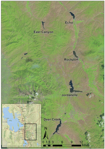
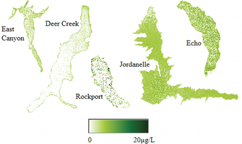
We selected 5 reservoirs in the Wasatch Mountains: Deer Creek, Jordanelle, Echo, East Canyon, and Rockport for this case study. Other than size differences, these reservoirs are similar in physical characteristics and elevation, and they are close enough to be in a single Landsat image (). Deer Creek Reservoir is downstream from Jordanelle and in the same watershed; the other 3 reservoirs are in a different watershed.
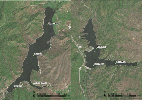
Deer Creek and Jordanelle reservoirs have been part of a detailed long-term field sampling campaign and were selected because of the availability of these long-term study data and consistency in field sampling techniques. The long-term study has monitored water quality since the early 1980s as part of mitigation efforts to address high levels of phosphorus and algal biomass (UDEQ Citation2004a). The data we used in this study were taken at designated locations ().
Echo, East Canyon, and Rockport reservoirs are nearby and similar to Deer Creek and Jordanelle. These 3 reservoirs were selected to demonstrate how Landsat data and remote sensing seasonal models can be used to analyze and monitor reservoirs with no available field data (Kloiber et al. Citation2002, Fuller et al. Citation2004, Wang et al. Citation2004, Olmanson et al. Citation2008, 2011).
Deer Creek Reservoir
Deer Creek is located in the Wasatch Mountains on the Provo River and supplies potable water for much of the Salt Lake City valley. The reservoir has a surface area of 1200 ha (2965 ac), with a capacity of ∼240 million m3 (193,600 ac-ft) and a maximum depth of 42 m (137 ft) near the dam (UDEQ Citation2004b). In addition to recreational use, agriculture and potable water supply accounts for 38% and 62% of water use, respectively. Potable use is expected to increase as the area continues to develop. Deer Creek Reservoir was identified as highly eutrophic in the 1970s and 1980s and continues to exhibit high phosphorus and low dissolved oxygen levels during the summer.
Jordanelle Reservoir
Jordanelle is a large reservoir with a surface area of about 1335 ha (3300 ac) and feeds into Deer Creek Reservoir. It has a capacity of approximately 445 million m3 (360,500 ac-ft) and a maximum depth of 89 m (292 ft; UDEQ Citation2004a). The dam was completed and the reservoir completely filled in 1994. Jordanelle is used for a wide range of purposes including recreation, irrigation, industrial, and potable water supply.
East Canyon Reservoir
East Canyon is a 276 ha (684 ac) reservoir located behind the Wasatch Mountains (UDEQ Citation2004c). It has a capacity of approximately 63 million m3 (51,200 ac-ft) and a maximum depth of 60 m (197 ft). Its water is used primarily for agriculture, although culinary use is increasing. East Canyon is a popular year-round recreational area, with more than 100,000 visitors annually. The surrounding watershed is relatively dry compared to the other watersheds in the area. One of the main concerns for this reservoir is the rapid urbanization and development in the contributing watershed.
Rockport Reservoir
Rockport Reservoir is a 481 ha (1189 ac) impoundment on the Weber River, with a capacity of 93.4 million m3 (75,730 ac-ft) and a maximum depth of 45 m (150 ft; UDEQ Citation2004b). Rockport is used for potable water supply and agriculture. Although the historical water quality of the reservoir has been good, conditions have exceeded standards for phosphorus and dissolved oxygen, issues that are closely related to algal biomass.
Echo Reservoir
Echo Reservoir is also on the Weber River, located north of Rockport Reservoir. It is comparable to Rockport in size at 564 ha (1394 ac), 91.1 million m3 (73,900 acre-feet) capacity, and a maximum depth of 33.5 m (110 ft; UDEQ Citation2004d). Echo Reservoir provides agricultural and potable water to the Northern Wasatch Front and, along with Rockport Reservoir, is a popular recreation spot. Reservoir drawdown due to irrigation in the late-summer causes drastic changes to the shoreline and in-reservoir productivity and may cause premature turnover. Because conditions caused by management requirements are so extreme, lake characteristics are highly dependent on water use and management.
Methods
Hansen and coauthors (Hyatt et al. Citation2012, Hansen et al. Citation2013a, Citation2013b, 2014) previously developed seasonal models for Deer Creek Reservoir using Landsat-5 and Landsat-7 reflectance measurements and demonstrated that seasonal models were more accurate than a single-season model for Deer Creek (Hansen et al. Citation2013a).
This case study generalizes the previous work by demonstrating regional application using models developed with a more extensive dataset and shows how this approach can be used to develop a long-term record of water quality in several reservoirs from historic Landsat data. We used data from 2 reservoirs, Deer Creek and Jordanelle, to develop seasonal models then applied these models to similar regional reservoirs without sufficient field data for model development. We show how historical data in a region can be used to develop seasonal models that can be applied to the reservoirs that provided the data to develop the models as well as to other reservoirs in the area. Because the seasonal models can be applied to other satellite collections that occurred in the same season, this approach supports chlorophyll estimates to define long-term trends, provides frequent updates on reservoir conditions, supports comparison among reservoirs, and may be used for short-term forecasting.
This effort extends previous work. Studies have shown that reliable results for model development can be obtained using noncoincident data, up to ±3 days from a satellite collection, especially if more data are used for model development (Kloiber et al. Citation2002, Olmanson et al. Citation2008) and remote sensing models developed using data from a limited number of reservoirs have been applied to other regional reservoirs to evaluate general water quality trends (Sawaya et al. Citation2003, Fuller et al. Citation2004, Wang et al. Citation2004, Olmanson et al. Citation2008, 2011). We used seasonal models developed with noncoincident data and applied them to other reservoirs in the region to analyze historic conditions, extending the previous work by using seasonal models that allow us to analyze data throughout the year and to apply these models to archived satellite data to generate long-term estimated chlorophyll datasets. This approach provides both more accurate models and the ability to monitor reservoirs (or analyze historic trends) throughout the growing season.
We used archived chlorophyll field data from Deer Creek from 1984 to 2012 (54 samples) and Jordanelle from 1993 to 2012 (31 samples) collected at several sampling points (). We used only data collected on the same day or within 24 hours (mid-season model) of a satellite image from the Landsat-5 Thematic Mapper (TM) from 1984 to 1999 and Landsat-7 Enhanced Thematic Mapper Plus (ETM+) from 1999 to 2012. The field data were collected independently of the Landsat acquisition schedule, but for model development we used only data that were nearly coincident; the long-term data archive provided a relatively large dataset (85 samples), even with these time constraints.
We separated the growing season into 3 periods with relatively similar phytoplankton communities: early-season April–May, mid-season June–July, and late-season August–September. These divisions were based on some limited phytoplankton population data and were suggested as appropriate by reservoir managers.
For model development we used field data taken on the same day but not coincident with a satellite overpass for early- and late-season models, and within 24 hours of a satellite overpass for the mid-season model because of the low number of same-day field and satellite data available. We used only field samples taken within 2 m of the surface. These constraints resulted in 18 early-season samples (Apr–May), 42 mid-season samples (Jun–Jul), and 25 late-season samples (Aug–Sep). Typically, field samples are collected coincident with satellite overpasses, limiting the uncertainty associated with temporal variability due to winds and currents, but also limiting the number of samples available for model development; having only 4 or 5 field samples is not unusual in reported studies. Our use of near-coincident data introduced some uncertainty associated with temporal variability but provided relatively large datasets for model development.
The Landsat images were radiometrically calibrated and atmospherically corrected. For the area around each field sampling point, we selected a group of 9 pixels centered on the field sample location and computed a mean-filtered average reflectance for bands 1–5 and 7. Using the mean-filtered average removes noise from the data (Johnson et al. Citation2013). The mean-filtered average value for each band was computed as:
(1) where
is the unfiltered mean, σ is the unfiltered standard deviation, and N is the number of values within ±1.5*σ. These mean-filtered reflectance values were then used for model creation.
We used the data from both Deer Creek and Jordanelle for model development, resulting in seasonal models with better correlations than the seasonal models developed with only Deer Creek data (Hansen et al. Citation2013a), with correlation increases on the order of those expected from the additional data points. Statistical cluster analysis (k-means clustering; D’Ortenzio and Ribera d’Alcalà Citation2009, Kim et al. Citation2009) could not distinguish between data from the 2 reservoirs, supporting combining data from the 2 reservoirs for model development. The 2 datasets were statistically the same, implying that the resulting seasonal models can be used for reservoirs in the region where general water color and algal succession are similar. We assumed data from the other reservoirs would follow this pattern.
Model development
Most models reported in the literature are developed using a multiple least-squares approach in which a model form is selected and a least-squares fit is used to determine model coefficients (Gitelson Citation1992, Gitelson et al. Citation2007). A combination of Landsat Bands 1, 2, 3, and 4 are generally used. For example, Fuller et al. (Citation2004) in a study that estimated chlorophyll concentrations in 750 Michigan inland lakes selected 4 different model forms and then used a stepwise regression approach to fit coefficients and compute a coefficient of determination (R2) value for each equation form. They used chlorophyll field data collected in late August and early September 2002 to evaluate 4 different model forms for their study: a linear combination of b1, b2, b3, b4, b5, and b7 (trial 1); a linear combination of b4/b3, b2/b3, b2-b3, b1/b2, and b3/b1 (trial 2); a linear combination of (b2+b3)/b2, b22, b32, (b1+b2)/2, (b1+b3)/2, and b3/b4 (trail 3), and a linear combination of b2, b3, b7, b3/b1, b32, and (b1+b3)/2 (trial 4). They found the best fit to their data was from trial 1 with an equation of:
(2) which yielded an R2 of 0.81 (Fuller et al. Citation2004).
We followed the model development methods from Hansen et al. (Citation2013a). In this approach, rather than selecting a limited number of model forms, such as the 4 forms selected by Fuller et al. (Citation2004), we used a generalized multiple least-squares stepwise regression approach (Hansen et al. Citation2013a). Rather than using only a limited number of equation forms, this approach evaluates all potential equations that could result from different explanatory variables, consisting of a list of bands and band ratios that can be combined in complex forms. The multiple linear least squares regression technique models the relationship between the scalar dependent variable y (Chl-a) and several explanatory variables xi (Landsat reflectance data in the various bands and band combinations). To reduce over-fitting and develop more tractable models, the number of explanatory variables in the final model is limited. The algorithm selects which variables and coefficients to use in the resulting predictive equation to minimize the error. This process assumes that the relationship between yi and the regressors, xi, is linear so that y can be estimated based on a linear combination of a set of x. The resulting model takes the form:
(3) where yi is the estimated Chl-a value at a location i; xip are the satellite data (values of bands or band ratios p) at location i; and ϵ is the error.
For model development we used 36 possible parameters (Landsat bands or band ratios) as input to the generalized multiple least-squares stepwise regression algorithm. We limited the number of parameters selected for the final model by limiting the addition of model terms to those in which the step-wise increase in the R2 value was >5%; in other words, if including another parameter did not increase the model fit by at least 5% (as measured by the R2 value), the algorithm stopped. This resulted in 2 models with 5 parameters and 1 model with 6 (from the possible 36 parameters). This approach differs from commonly presented methods where preselected model forms are fitted and evaluated using a least squares fit (Castenholz Citation1960, Casterlin and Reynolds Citation1977, Brivio et al. Citation2001, Östlund et al. Citation2001, Stadelmann et al. Citation2001, Fuller et al. Citation2004) because it does not presuppose a model form or number of model parameters.
Stepwise regression requires the data to be normally distributed; the early-season data were normally distributed, but the mid- and late-season data required log transforms. To determine if data were normally distributed we followed the model specification methods from Hansen et al. (Citation2013a).
The resulting 3 seasonal chlorophyll models are (where b1 is Landsat Band 1, b2 is Landsat Band 2, etc. and chl is chlorophyll in μg/L):
Early-season (Apr–May):
(4) where β1 = 10.86, β2 = 0.83, β3 = −0.82, β4 = −9.07, and β5 = 0.96. This model was developed with 18 samples collected the same day as the corresponding satellite images and had an R2 of 0.83 and a root mean squared error (RMSE) of 1.03.
Mid-season (Jun–Jul):
Late-season (Aug–Sep):
The actual and model-predicted chlorophyll values used to develop each of the 3 models are shown in
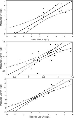
The models for early- and late-seasons had better R2 values than the model for mid-season. The early and late periods have more stable phytoplankton populations, and the data used were collected the same day as the corresponding satellite image. The mid-season is a transition period with changing phytoplankton populations. In addition, we had fewer data, meaning we had to use data collected further in time (24 h rather than the same day). In addition the chlorophyll data were not normally distributed, requiring a log-transform for model development. All these factors contribute to uncertainty in the mid-season model. The late-season model also required a log-transform but used near-coincident data (same day).
Model application
We used ENVI v4.7 (Exelis Visual Information Solutions, Boulder, CO) as the base software platform for applying the models to historical images. We calibrated the selected Landsat images using the Landsat radiometric calibration and atmospheric correction methods in ENVI. We implemented the subseasonal models within ENVI using the bandmath component and used the ISODATA unsupervised classification (Gonzalez and Tou Citation1974) technique in ENVI to distinguish between water and land pixels and created regions of interest (ROI) representing each reservoir based on this classification. We then applied the models to the pixels within each ROI, allowing us to mask background pixels so we could perform statistical analyses on the results of the chlorophyll detection algorithms.
We calculated a number of different statistical measures to describe chlorophyll concentrations for each image for each reservoir, resulting in values of the maximum (as the 95th percentile), minimum, mean, mode, and standard deviation for each reservoir for each date we had an acceptable satellite image. We used the mode of chlorophyll concentration rather than the mean in reporting because the mode is less influenced by outliers, and remote sensing data are noisy and often contain extreme values. The mode addresses the central tendency of the distribution and is less dependent on noise or extreme values. Noise can have a large impact on the reservoir maximum value, so to minimize this effect, we report the maximum value for a reservoir on the date of the satellite collection as the 95th percentile of the distribution calculated from all the reservoir image pixels:
(7) where,
is the mean of estimated chlorophyll in the reservoir on that date and σ is the standard deviation. This equation avoids using the single pixel with the highest value, which could most likely be attributed to noise in the image rather than a true high chlorophyll value.
Model verification
We were not able to validate the resulting models because our data were insufficient, but we were able to evaluate several issues that support the validity of these models.
Hansen et al. (Citation2013a) evaluated application of models developed using data from one season to another and presented detailed results for Deer Creek by applying models developed for one season to images from another season and comparing the results with field measurements. When the late-summer model was used to predict early-summer and mid-summer conditions, the resulting R2 values of 0.2 and 0.0728, respectfully, were significantly lower than for season-specific models applied to in-season data. An all-season model was also developed using all the available data, resulting in an R2 of only 0.546, lower than any of the season-specific models. The all-season model applied to individual seasons resulted in poor model fits for early- and mid-season data, with R2 values of 0.0995 and 0.1599, respectively. The fit was better for the late season data, although still not as close as the season-specific model.
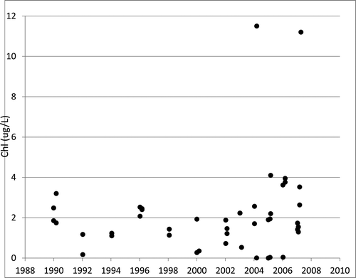
We obtained Utah Department of Environmental Quality (UDEQ) data from the EPA STORET database for Echo Reservoir. Of the 59 data points available from 1990 through 2007 during the June–September period, 46 had satellite images available within 7 days of the field sample and were free from cloud cover ().
Our approach is difficult to validate with these data due to significant differences in time between field and satellite collection. Also, the Echo Reservoir data available in STORET exhibited significant variability, even for data collected on the same date. For example, 2 samples were reported for 1 July 2002 with values of 0.2 and 8.1 μg/L and 2 values reported for 23 July 2003 with values of 0.4 and 26.4 μg/L, resulting in differences for samples reported on the same day of 7.9 and 26.0 μg/L, respectively (data from 23 July 2003 not shown in because no satellite image was available for that date.)
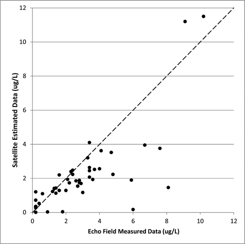
We used the appropriate seasonal model with the closest-in-time satellite images (within 7 days) to predict chlorophyll concentrations at the Echo Reservoir sample locations, with estimates compared to field-measured values obtained from STORET (). The 1:1 line, or perfect prediction (), shows that the model successfully estimates chlorophyll concentrations. While some of the evident error is probably due to the model, we expect that model errors are on the same order of magnitude as the variability in the STORET data.
Results and discussion
Trends in reservoir statistics
We used the slope of the least-squares regression line from 1984 to present, or 1993 to present for Jordanelle Reservoir (it was not filled before this year), to represent trends for the average (mode), maximum (95th percentile), and the standard deviation of each of the 5 reservoirs (). These trends, which use data from the entire reservoir rather than a few sampling points, help explain how the reservoirs have changed over time in a general sense. The mode indicates the overall quality of the reservoir, the maximum indicates the magnitude of blooms, and standard deviation values are indicative of spatial differences across a reservoir. A trend in the mode can be taken as a general index to reservoir health, showing either decreasing or increasing algal presence. Trends in the maximum and standard deviation describe the reservoir processes. As noted, the maximum indicates algal bloom size (e.g., a decreasing trend would indicate smaller blooms). Standard deviation is a measure of reservoir uniformity, and a decreasing trend indicates that chlorophyll concentrations are becoming more uniform with fewer areas that are much higher or lower than the average concentration. These 3 indices of change can be used together to gain a more holistic understanding of reservoir behavior. For example, a small bay could receive nutrients and continue to exhibit a large algal bloom while conditions in the rest of the reservoir are improving. In this case, the mode may show a decreasing trend, but the maximum may have no trend, with the standard deviation exhibiting an increasing trend, indicating that localized blooms in the bay are not improving. These types of indexes, while not providing detailed information on reservoir conditions, can be used to monitor conditions over time and prompt managers to review concentration distribution maps or concentration change maps to identify problem areas.
Table 1 Trends by subseason and reservoir.
The seasonal data () show that late-season conditions in the 5 reservoirs change more than conditions in earlier seasons. While these data do not indicate why the change is occurring, this knowledge can help managers allocate limited resources, such as field sampling efforts, to focus on late-season conditions to determine the cause. The maximum, standard deviation, and average estimates for Jordanelle Reservoir all exhibit decreasing trends for the late-season while the early-season data show a slight rise in all 3 indices, with the average showing less increase. The increase in the maximum and standard deviations indicates that small localized blooms may be occurring in early-summer, and the reservoir may require additional monitoring to understand these increasing trends and increasing variability, and to identify the reservoir locations responsible for these changes. Spatial distribution maps (discussed next) generated from the Landsat data can provide information on where these anomalies are occurring and can be used to develop field sampling plans to better understand causes.
In each of the reservoirs, with the exception of Echo, the largest noted trend was a decrease in maximum chlorophyll levels over the study period. This trend means the highest concentration seen in the reservoir is decreasing over time, perhaps indicating fewer blooms. The standard deviation is also decreasing, showing less variability across the reservoir over time, meaning conditions are becoming more uniform. This information collectively implies that blooms are becoming less severe over time. While these data do show decreasing trends, the decrease is slight, and the variability is significantly larger than the trend.
Spatial distribution maps
Exploited Landsat images provide spatial distribution maps of estimated chlorophyll concentrations and are quantitative visualizations of the water quality across a reservoir. Based on our experience, chlorophyll concentrations are rarely evenly distributed within a reservoir, and identifying areas of both high and low concentrations can help understand reservoir processes and identify potential causes. Differences in spatial distribution among the 5 reservoirs () could be caused by various processes such as inflows from tributaries or prevailing winds that drive surface algal into bays or against shorelines. These maps can help a knowledgeable reservoir manager to differentiate among various causes of algal variability or to identify potential issues associated with reservoir processes. For example, identifying an area with more frequent blooms could allow a reservoir manager to focus on that area to determine if the “blooms” are caused by issues such as nutrients that may be amenable to management controls or if the areas of high concentrations are due to prevailing winds or currents rather than actual blooms.
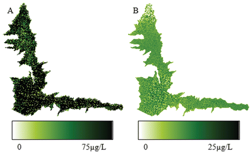
Estimated Deer Creek Reservoir concentrations are spatially highly variable (), with low concentrations near the dam (lower end) and higher concentrations in the upper end, along the shore, and in some bays on the east side. These high concentrations may be caused by various reservoir processes, but the prevailing winds blow to the east, likely causing the higher concentrations seen in these areas. Likewise, Rockport and East Canyon exhibit areas of higher concentrations on the shoreline, with highly variable concentrations through the rest of the reservoirs. For these 2 reservoirs, images from other dates show this pattern is common and persistent, indicating a consistent driving factor and implying that wind may not be the dominant cause. This case study does not attempt to determine the causes of the patterns presented, a process that would require field data we do not possess; rather, we only present remote sensing data along with conjectures on how these data could be used by reservoir managers.
In contrast, Echo Reservoir shows a relatively even spatial concentration distribution across the reservoir. Jordanelle has high concentrations similar to Echo but shows slightly more spatial variation, with the upper part of the north arm showing lower concentrations. Jordanelle images from other years show higher concentration near the dam and in the southeast arm, with the northern arm generally exhibiting lower concentrations.
These images demonstrate that field samples may or may not represent general reservoir conditions depending on where and when they were taken and spatial variability. Distribution maps from satellite data can inform field sampling activities and help evaluate past sampling efforts to determine if the samples taken were/are representative of the entire area or are located in areas of relatively high or low concentrations.
As a brief example of how these maps could be used to evaluate field sampling, chlorophyll distributions in Echo Reservoir on the date of the image () are relatively uniform, and field sample values would not be sensitive to location, implying that field samples taken anywhere in the reservoir on this day would accurately represent the entire reservoir because there is little variation. Deer Creek on this same date, however, exhibits significant spatial variation in chlorophyll concentrations, and depending on the location of the field samples, values could have either high or low values and not necessarily represent general reservoir conditions. Taking a sample in the lower portion of Deer Creek on this date would result in much lower chlorophyll values than samples taken in the upper portions of the lake (). Depending on where field samples were taken, they may or may not provide an accurate representation of the state of the Deer Creek Reservoir; samples near the dam would provide different results from samples in the upper end.
Seasonal variations
We observed significant variation in the average chlorophyll concentration between the seasons () and between the reservoirs through time (). For example, the Deer Creek late-season estimates (lower panel of , line with circles) shows high estimated chlorophyll concentrations in 1985 and 1998 and lower estimated concentrations in 1988 and 1991. This information provides a different picture than the large decreasing trend in late-season Deer Creek concentrations (, ), but while this trend exists, in any given year a large bloom could occur because seasonal behavior has large variations. The historical Landsat data archive and regular 16-day collection schedule allow development and analysis of a time history of estimated reservoir chlorophyll distributions, can inform managers of the magnitude of the variation to expect in a reservoir, and if images are analyzed as they become available, they may be useful in identifying short-term trends. Complete spatial observations of a reservoir throughout the growing season and over time help provide a more complete picture of the reservoir behavior.
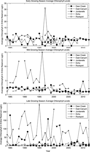
Trend analysis, statistical measures, and spatial maps can each provide insight into reservoir processes. Trends provide an overview of the entire reservoir and are reliable indices for tracking reservoir health and response to mitigation measures; however, trend data () may not be helpful in identifying specific reservoir areas or processes of concern. Statistical changes over both short-term (seasonal) and long-term time frames () provide a more complete description of reservoir variability. Spatial distribution maps ( and 7) provide details on spatial reservoir processes and could, as noted, inform field sampling design or analysis, identify areas for study or mitigation efforts, or help evaluate the efficiency of mitigation efforts.
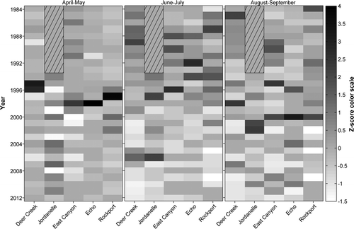
Time-series z-score matrices
Another way to visualize water quality trends is through matrices of normalized z-score transforms (). A z-score, a dimensionless value, quantifies the number of standard deviations an observation is above (positive) or below (negative) the mean. This score is useful for 2 reasons: it allows comparisons of populations that have widely different mean values, and it allows easy identification of extreme or unusual events (high or low z-values). This method can be used to compare 2 reservoirs, even if the average concentration in the reservoirs is significantly different. The z-score is calculated as:
(8) where x is the data value and μ and σ are the average and standard deviation of the dataset, respectively.
We computed z-scores using the full time period for each reservoir and present these data as raster plots in 3 panels (). The z-scores are represented as grayscale values ranging from −1.5 (white) to 4 (black), a range of standard deviations that indicates the large variability in the dataset. The left panel represents data from the early-season model (Apr–May), the middle panel represents data from the mid-season model (Jun–Jul), and the right panel represents the data from the late-season model (Aug–Sep; ). Because the scale was selected to clearly differentiate among values in the range from −1.5 to 2.5, the scale does not extend beyond these values; however, the maximum values for the early-, mid-, and late-season models are 4, 3, and 2.5, respectively, indicating that the mode of estimated reservoir chlorophyll concentrations in these extreme years was statistically estimated to be higher than 99.99%, 99.7%, and 98.8% of the years studied, for the early-, mid-, and late-season periods, respectively. There is significantly more variation in the early-season yearly average than in the late-season data, with the maximum z-scores representing 4 versus 2.5 standard deviations, respectively ().
Visual comparisons are somewhat difficult, The variations are slight for the extreme values because the scale was selected to more clearly differentiate the middle of the range. We therefore chose to use a grayscale legend to visualize time periods with above or below average results, both across the different reservoirs and across the different seasons.
We expected some temporal correlation between the reservoirs, with high or low values occurring in each of the reservoirs in the same year creating dark or light bands, but these bands do not appear. Instead, correlations seem more complex, with highs and lows seeming to occur in periods (wider bands) but not necessarily specific years (). For example, the early-season panel shows that Echo, East Canyon, Deer Creek, and Rockport all exhibited large blooms in 1995 through 1998, with blooms in Deer Creek appearing early in this time frame and in the other reservoirs later. Jordanelle shows values below the mean for this period, which can be partially explained by the filling of Jordanelle during this period because the dam was only closed in 1994.
The mid-season data show all the reservoirs exhibiting a greater number and higher magnitude of blooms in the early years, with later years showing fewer large z-score events, and only Deer Creek and Jordanelle exhibiting blooms in 2005–2006. The mid-season panel shows maximum concentrations in all the reservoirs decreasing over time, similar to the trend value, but these plots provide a unique visual description and allow a more direct comparison among the reservoirs, even though the absolute concentrations are different.
The late-season data also show a general decrease over time for maximum value (lighter values toward the bottom of ), but they also show the lack of correlation among the reservoirs in the late season. For all the reservoirs, 1996 to 2000 shows indications of blooms, but they occur at different times for each reservoir.
For all 3 panels, the Rockport and Echo patterns are slightly more similar to each other than to the other reservoirs, possibly because they are in the same drainage and more similar in location (). The same is true of Deer Creek and Jordanelle after Jordanelle filled (they are also in the same drainage). Note that this similarity pattern is present in these dimensionless values, even though the concentration data are an order of magnitude different in value.
This study is not meant to provide accurate descriptions of reservoir processes or causes of chlorophyll concentration changes, but rather provide simple examples of how remote sensing data exploited in seasonal models could be used to infer information about a reservoir or lake. Using seasonal models allows the computation of long-term trends useful in attempting to understand complex processes. We expect that in actual use, a reservoir manager would combine these data with other data and information to characterize various processes.
Forecasting
As noted, Landsat images are collected every 16 days, weather permitting. This ability to obtain data with high temporal resolution allows short-term trends to be monitored and potentially predict blooms. The potential for short-term forecasting (within seasons and from one season to the next) provides an additional motivation for using Landsat data to monitor chlorophyll during the growing season. Once seasonal models are developed, processing new satellite images requires minimal effort.
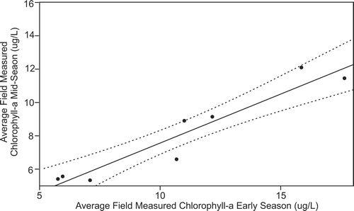
We used Deer Creek to demonstrate how Landsat data could potentially be used to forecast future conditions using field-measured data rather than data estimated from satellite images. This case study has not been validated and is only meant to show how these data could be used. If this correlation holds, however, then estimates from satellite images could be used to predict future conditions.
In this example, we analyze the correlation of field data from one season to the next. The early- and mid-season data values are correlated, implying some possible predictive value (). Some predictive value is expected because reservoir conditions are correlated in time, and because conditions close in time are more similar than those far apart in time, shorter-term predictions on the order of the 16-day collection schedule are expected to have more accuracy than predictions at longer scales.
The Deer Creek data show that the average field-measured chlorophyll levels, >5 μg/L from the early-season, positively correlate with chlorophyll measurements in the mid-season (), indicating that results from satellite collections from the early-season could be used to forecast future conditions in the mid-season, and more important, these forecasts can be updated and refined every 16 days (weather permitting).
While a correlation exists between early- and mid-season concentrations, data are not sufficient for a simple prediction model. The data seem to show (although we do not have enough data to confirm) 2 populations or groupings in the data. The data groups indicate that if early-season values are <10 μg/L, then mid-season values will likely be relatively low, <6–8 μg/L. If early-season values are >10 μg/L, however, then mid-season values will likely be as high as 10 μg/L or higher. It seems that actual mid-season concentrations cannot be predicted based on the early-season values, but general conditions can be predicted (above or below 10 μg/L). Again, we stress that this is a simple example using available information and limited data; developing usable predictive methods would require more analysis and validation. A study using all the field data could validate this approach, which could then be used with estimated chlorophyll values collected at high temporal resolutions.
Conclusions
Products of seasonal models
Remote sensing data provide valuable information about the spatial distribution of chlorophyll in reservoirs, information difficult or impossible to obtain with field samples because of limited spatial and temporal coverage. Landsat remote sensing data for North American reservoirs exists every 16 days from 1984 to present (weather permitting). These data can be used to statistically analyze historical trends to represent reservoir measures such as average, maximum, and variance in algal concentrations and to develop visualizations to provide more detailed reservoir descriptions. The spatial distribution maps of chlorophyll can help visualize reservoir behavior, indicating possible problem areas and identifying locations for field sampling.
We demonstrated several ways to analyze and study these estimated chlorophyll data, such as statistical measures, trend line, spatial distribution maps, and z-score images. Looking at and analyzing remote sensing data in different ways can help describe and understand reservoir and regional behavior.
Applications of seasonal models
We demonstrated development of chlorophyll estimate models using historical data and showed how these seasonal models could be applied to images acquired in the same region. Model applications were developed using historical data from a few reservoirs to other reservoirs in a region, allowing analyses of many reservoirs and comparisons among reservoirs. While estimated concentrations using this approach may not be precise, changes in concentration over time and spatial distributions are relatively accurate, implying that even reservoirs without field data can be monitored as long as the optical characteristics of the reservoirs are similar.
For the 5 reservoirs used in our case study, we observed that each demonstrated unique behavior, both historically and within the growing season. Managers can use this knowledge to identify which reservoirs require additional monitoring or mitigation efforts. Because the Landsat data provide full spatial coverage, they may better identify which areas of a reservoir should be targeted for field sampling.
This case study demonstrated the value of using subseasonal Landsat models to estimate chlorophyll and how these results support decision-making for water quality managers. Once the initial subseasonal models are developed, application to historical and current images can be semi-automated and provide an efficient method to analyze historic trends, monitor current reservoir conditions, or forecast future conditions.
References
- Anderson DM, Glibert PM, Burkholder JM. 2002. Harmful algal blooms and eutrophication: nutrient sources, composition, and consequences. Estuaries. 25(4):704–726.
- Brando VE, Dekker AG. 2003. Satellite hyperspectral remote sensing for estimating estuarine and coastal water quality. IEEE Trans Geosci Remote Sens. 41(6):1378–1387.
- Bricaud A, Babin M, Morel A, Claustre H. 1995. Variability in the chlorophyll-specific absorption coefficients of natural phytoplankton: analysis and parameterization. J Geophys Res-Oceans. 100(C7):13321–13332.
- Brivio P, Giardino C, Zilioli E. 2001. Determination of chlorophyll concentration changes in Lake Garda using an image-based radiative transfer code for Landsat TM images. Int J Remote Sens. 22(2-3):487–502.
- Castenholz RW. 1960. Seasonal changes in the attached algal of freshwater and saline lakes in the Lower Grand Coulee, Washington. Limnol Oceanogr. 5:1–28.
- Casterlin ME, Reynolds WW. 1977. Seasonal algal succession and cultural eutrophication in a north temperate lake. Hydrobiologia. 54(2):99–108.
- D’Ortenzio F, Ribera d’Alcalà M. 2009. On the trophic regimes of the Mediterranean Sea: a satellite analysis. Biogeosciences. 6(2):139–148.
- Fuller LM, Aichele SS, Minnerick RJ. 2004. Predicting water quality by relating Secchi-disk transparency and chlorophyll a measurements to satellite imagery for Michigan inland lakes, August 2002. US Department of the Interior, US Geological Survey.
- Gitelson A. 1992. The peak near 700 nm on radiance spectra of algal and water: relationships of its magnitude and position with chlorophyll concentration. Int J Remote Sens. 13(17):3367–3373.
- Gitelson AA, Schalles JF, Hladik CM. 2007. Remote chlorophyll-a retrieval in turbid, productive estuaries: Chesapeake Bay case study. Remote Sens Environ. 109(4):464–472.
- Gonzalez R, Tou J. 1974. Pattern recognition principles. Applied Mathematics and Computation. Reading (MA): Addison-Wesley.
- Gordon HR, Brown OB, Evans RH, Brown JW, Smith RC, Baker KS, Clark DK. 1988. A semianalytic radiance model of ocean color. J Geophys Res-Atmos. 93(D9):10909–10924.
- Gordon HR, Morel AY. 1983. Remote assessment of ocean color for interpretation of satellite visible imagery: a review. NASA.
- Hansen CA, Adjei Z, Williams GP, Miller AW. 2014. Watershed GIS and remote sensing to assess regional water quality. AWRA Spring Specialty Conference: GIS and Water Resources VIII - Data to Decisions, AWRA, Snowbird Resort, Salt Lake City, UT.
- Hansen C, Swain N, Munson K, Adjei Z, Williams GP, Miller W. 2013a. Development of sub-seasonal remote sensing chlorophyll-a detection Models. Am J Plant Sci. 4:21.
- Hansen CA, Williams GP, Miller AW. 2013b. Regional scale application of remote-sensing chlorophyll detection models and analysis of North-Central Utah region. North American Lake Management Society (NALMS) 33rd International Symposium, San Diego, CA.
- Hyatt C, Williams GP, Swain N, Gonzalez N, Stodmiester A, Nelson EJ, Miller AW. 2012. Developing seasonal models to accurately assess algal succession and water quality using remotely sensed data: a case study at Deer Creek Reservoir, Utah lakes in the landscape: values>visions>actions. NALMS 2012, 32nd International Symposium of the North American Lake Management Society, Madison, WI.
- Johnson R, Strutton PG, Wright SW, McMinn A, Meiners KM. 2013. Three improved satellite chlorophyll algorithms for the Southern Ocean. J Geophys Res-Oceans. 118(7):3694–3703.
- Kim H-C, Yamaguchi H, Yoo S, Zhu J, Okamura K, Kiyomoto Y, Tanaka K, Kim S-W, Park T, Oh I, et al. 2009. Distribution of Changjiang diluted water detected by satellite chlorophyll-a and its interannual variation during 1998–2007. J Oceanogr. 65(1):129–135.
- Kloiber SM, Brezonik PL, Olmanson LG, Bauer ME. 2002. A procedure for regional lake water clarity assessment using Landsat multispectral data. Remote Sens Environ. 82(1):38–47.
- Olmanson LG, Bauer ME, Brezonik PL. 2008. A 20-year Landsat water clarity census of Minnesota's 10,000 lakes. Remote Sens Environ. 112(11):4086–4097.
- Olmanson LG, Brezonik PL, Bauer ME. 2011. Evaluation of medium to low resolution satellite imagery for regional lake water quality assessments. Water Resour Res. 47(9).
- Östlund C, Flink P, Strömbeck N, Pierson D, Lindell T. 2001. Mapping of the water quality of Lake Erken, Sweden, from imaging spectrometry and Landsat Thematic Mapper. Sci Total Environ. 268(1):139–154.
- Sathyendranath S, Platt T, Stuart V, Irwin B, Veldhuis M, Kraay G, Harrison W. 1996. Some bio-optical characteristics of phytoplankton in the NW Indian Ocean. Mar Ecol Prog Ser. 132(1):299–311.
- Sathyendranath S, Watts L, Devred E, Platt T, Caverhill C, Maass H. 2004. Discrimination of diatoms from other phytoplankton using ocean-colour data. Mar Ecol Prog Ser. 272:59–68.
- Sawaya KE, Olmanson LG, Heinert NJ, Brezonik PL, Bauer ME. 2003. Extending satellite remote sensing to local scales: land and water resource monitoring using high-resolution imagery. Remote Sens Environ. 88(1–2):144–156.
- Stadelmann TH, Brezonik PL, Kloiber S. 2001. Seasonal patterns of chlorophyll a and Secchi disk transparency in lakes of east-central Minnesota: implications for design of ground-and satellite-based monitoring programs. Lake Reserv Manage. 17(4):299–314.
- Stuart V, Sathyendranath S, Head E, Platt T, Irwin B, Maass H. 2000. Bio-optical characteristics of diatom and prymnesiophyte populations in the Labrador Sea. Mar Ecol Prog Ser. 201:91–106.
- [UDEQ] Utah Department of Environmental Quality. 2004a. Jordanelle Reservoir Lake report.
- [UDEQ] Utah Department of Environmental Quality. 2004b. Rockport Reservoir Lake report.
- [UDEQ] Utah Department of Environmental Quality. 2004c. East Canyon Reservoir Lake report.
- [UDEQ] Utah Department of Environmental Quality. 2004d. Echo Reservoir Lake report.
- Wang Y, Xia H, Fu J, Sheng G. 2004. Water quality change in reservoirs of Shenzhen, China: detection using LANDSAT/TM data. Sci Total Environ. 328(1–3):195–206.