
ABSTRACT
Vehicle-specific power (VSP) has been found to be highly correlated with vehicle emissions. It is used in many studies on emission modeling such as the MOVES (Motor Vehicle Emissions Simulator) model. The existing studies develop specific VSP distributions (or OpMode distribution in MOVES) for different road types and various average speeds to represent the vehicle operating modes on road. However, it is still not clear if the facility- and speed-specific VSP distributions are consistent temporally and spatially. For instance, is it necessary to update periodically the database of the VSP distributions in the emission model? Are the VSP distributions developed in the city central business district (CBD) area applicable to its suburb area? In this context, this study examined the temporal and spatial consistency of the facility- and speed-specific VSP distributions in Beijing. The VSP distributions in different years and in different areas are developed, based on real-world vehicle activity data. The root mean square error (RMSE) is employed to quantify the difference between the VSP distributions. The maximum differences of the VSP distributions between different years and between different areas are approximately 20% of that between different road types. The analysis of the carbon dioxide (CO2) emission factor indicates that the temporal and spatial differences of the VSP distributions have no significant impact on vehicle emission estimation, with relative error of less than 3%.
Implications: The temporal and spatial differences have no significant impact on the development of the facility- and speed-specific VSP distributions for the vehicle emission estimation. The database of the specific VSP distributions in the VSP-based emission models can maintain in terms of time. Thus, it is unnecessary to update the database regularly, and it is reliable to use the history vehicle activity data to forecast the emissions in the future. In one city, the areas with less data can still develop accurate VSP distributions based on better data from other areas.
Introduction
Vehicle emissions have become the dominant source of air pollution in urban areas. In order to estimate vehicle emissions, a lot of models have been developed based on various parameters:
Average speed (e.g., Mobile Source Emission Factor Model [MOBILE], Emission Factor Model [EMFAC], and Computer Program to Calculate Emissions from Road Transport [COPERT])
Traffic situation (e.g., Handbook Emission Factors for Road Transport [HBEFA] and Assessment and Reliability of Transport Emission Models and inventory Systems [ARTEMIS])
Engine operating model (e.g., Comprehensive Modal Emission Model [CMEM])
Power demand (e.g., International Vehicle Emission Model [IVE] and Motor Vehicle Emissions Simulator [MOVES])
In recent years, vehicle-specific power (VSP) has been found to be highly correlated with vehicle emissions and it is used in many studies on emission modeling. VSP is defined as the instantaneous tractive power per unit vehicle mass, in unit of kW/ton (Jiménez-Palacios, Citation1999). The MOVES model provides the method to calculate VSP, as shown in eq 1 (U.S. Environmental Protection Agency [EPA], 2010).
where v is the vehicle speed; a is the acceleration; g is the acceleration due to gravity; sin θ is the road grade; A, B, and C are road load coefficients, representing rolling resistance, rotational resistance, and aerodynamic drag, respectively; and m is the vehicle weight.
In the VSP-based emission models, both the emission rates and vehicle activities are derived by using a VSP binning method, in which the VSP values are categorized into various VSP bins. The running emissions are estimated basically by multiplying the emission rates with the VSP distribution (EPA, Citation2002; Davis et al., Citation2005), as shown in eq 2.
The emission rates in various VSP bins represent the vehicle emissions under different power demands. The VSP distribution, or operating mode (OpMode) distribution in the MOVES model, is the time fraction spent in each VSP bin (Frey et al., Citation2006; EPA, Citation2010). The emission rates are fixed for a specific type of vehicle (regulation class, fuel type, model year, weight, etc.). Thus, for a specific vehicle fleet, the VSP distribution determines the emissions in a traffic network.
Extensive efforts have been made towards the characteristics of the VSP distributions for the purpose of emission estimation. Frey et al. (Citation2006) examined the speed profiles of 13 runs on different links with average speed 30–40 km/hr and found a consistency in the VSP distributions of different runs. Yu et al. (Citation2008) employed the root mean square error (RMSE) to assess the difference between VSP distributions. Song and Yu (Citation2009) compared the VSP distributions of the expressway and non-expressway in Beijing and found their significant differences. Chamberlin et al. (Chamberlin et al., Citation2013; Talbot et al., Citation2014) compared the VSP distributions obtained from the MOVES model and the vehicle field data and calibrated a microsimulation model to the real-world VSP distribution. Wang et al. (Citation2015) investigated the VSP distribution characteristics of different freeway weaving configurations and their effects on vehicle emissions based on VISSIM.
Among these studies, three data sources are proposed to develop VSP distributions:
Drive schedule. The MOVES model employs 47 drive schedules to develop VSP distribution for light-duty vehicles (LDVs) according to the input of average speed for the national default case (EPA, Citation2011).
Output speed file of a microscopic traffic simulation model. However, this method has been questioned because of higher fractions of aggressive acceleration than real-world data (Song et al., Citation2015).
Vehicle activity data collected in the real world.
Some studies indicate that a bias is likely when using VSP as the only parameter of operating modes to simulate vehicle emissions, particularly under high or low speed (Cadle et al., Citation2008). Wang et al. (Wang and Fu, Citation2010; Wang et al., Citation2010) propose a speed and VSP modeling method. The MOVES model also develops default databases for the facility- and speed-specific VSP distributions (EPA, Citation2011). Although it is recommended to collect the local VSP distribution for emission estimation, particularly for project-level applications, the VSP distributions derived from the default driving schedules are commonly used in different years and in different areas. Consequently, the question arises: are the characteristics of the facility- and speed-specific VSP distributions consistent temporally and spatially?
In this context, the primary objective of this study is to analyze the consistency of the facility- and speed-specific VSP distributions developed in different years and in different areas respectively in order to answer the following two questions:
Is it needed to update the database of the VSP distributions in the emission model periodically?
Is it feasible to use the VSP distribution developed in one area of the city (such as the central business district [CBD]) to represent the vehicle operating mode in another (such as the suburb)?
Materials and methods
In this study, VSP distribution is defined as the time fraction spent in each VSP bin for a specific traffic condition of road type and average travel speed. The general method in this study includes three parts: (i) The facility- and speed-specific VSP distributions in different years and in different areas are developed respectively based on real-world LDV activity data. (ii) The RMSE is employed in order to quantify the difference between VSP distributions. (iii) The emission factor of carbon dioxide (CO2) is calculated to evaluate the impact of the temporal and spatial differences of the VSP distributions on the vehicle emission estimation.
Two data sources are included in this study: one is the LDV activity data to develop the VSP distributions, and the other is the vehicle emission data to develop the average emission rates in various VSP bins.
The LDV activity data were collected with portable Global Positioning System (GPS) devices from April 25, 2004, to April 16, 2013, in Beijing. The total number of the data point is 7,547,355, composed of 11,305 trips, provided by 178 LDVs. All the vehicles were driven by the owners.
The vehicle emission data were collected with the portable emissions monitoring systems (PEMS) instrument (OEM-2100; Clean Air Technologies International, Beijing, People’s Republic of China) on May 8, 2009, in Beijing. The basic parameters of the tested vehicle are listed in . A total of 10,870 records of the mass emission of CO2 from the tailpipe exhaust and the corresponding vehicle speed are reported in a second-by-second basis.
Table 1. Basic parameters of tested vehicles.
The VSP values are calculated by using eq 1 where sin θ is assumed to be 0 on the flat roads, whereas it is 0.04 on the bridges at the interchanges (Ministry of Housing and Urban-rural Development of China, Citation2012); g is 9.8017 m/sec2; and the recommended values of A, B, C, and m for LDVs are 0.156461, 0.0020002, 0.000493 and 1.4788, respectively (EPA, Citation2010).
Employing the VSP binning method (Song et al., Citation2012), as shown in eq 3, the VSP values are categorized into various VSP bins. Since 99% of the VSP values are between −20 and 20 kW/ton, each VSP distribution is developed within this range for the convenience of analysis.
VSP distributions in different years
The facility- and speed-specific VSP distributions in different years are developed in order to analyze the temporal consistency. The vehicle activity data are divided into two year groups:
“Before 2012,” for the collection date before 2012
“After 2012,” for the collection date in or after 2012
The data collected in 2004−2011 were put into the year group of Before 2012, whereas the data collect in 2012 and 2013 were put into the year group of After 2012, with a result that each group consists of about 3.5 million data records. The segregation of data into equal size is in order to avoid the effect of sample size of the data in the year groups on the development of VSP distributions. The data in each year group are separated into expressway and non-expressway, since there is significant difference between the VSP distributions of different road types (Song and Yu, Citation2009). A digital map of Beijing road network and a map-matching algorithm are employed to match the vehicle activity data to the corresponding road link. The coordinates, road type, etc., of each link in the map are available in its database.
In each year group and each road type, the VSP distributions in various average speed intervals are developed (Song et al., Citation2012). First, the activity data are cut into pieces of “trajectory,” each of which consists of continuous speed data of 180 sec. It is because (i) a long speed profile, like a driving cycle over 10 min, contains too many traffic patterns to produce stable and representative VSP distributions at a certain travel speed (Yu et al., Citation2010); (ii) the VSP distribution based on the temporal resolution of 180 sec includes both the driving characteristics on the road segments and at the intersections on the non-expressway according to the distribution of traffic control devices. Each trajectory is then put into a “pool” according to its average speed. All the trajectories are grouped into 38 speed intervals (0–2, 2–4, …, 72–74, >74 km/hr) on the expressway and 23 intervals (0–2, 2–4, …, 42–44, > 44 km/hr) on the non-expressway, with a result that each speed interval consists of at least 20 trajectories (3600 VSP values). The VSP distribution in each speed interval is developed by applying eq 3.
As an example of illustration, the VSP distributions and the 90% confidence intervals in eight speed intervals on the expressway and six speed intervals on the non-expressway are illustrated in , in both the year groups of Before 2012 and After 2012.
Figure 1. Facility- and speed-specific VSP distributions of different years (a) on expressway and (b) on non-expressway.
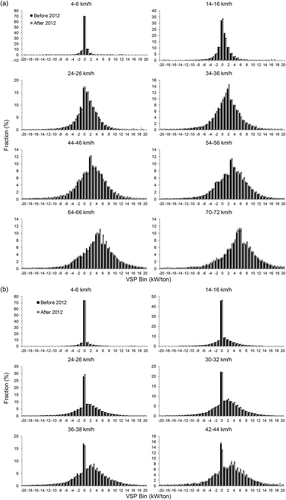
As can be seen, in each speed interval, the VSP distributions of different years are quite similar in pattern. The authors also developed the VSP distributions in the year group of “2004−2006” (for the Collection Date between 2004 and 2006) and “2013” (for the Collection Date in 2013). The same conclusion can be achieved. It is observed that the facility- and speed-specific VSP distributions are temporally consistent. A quantitative consistency analysis will be presented later.
VSP distributions in different areas
The facility- and speed-specific VSP distributions in different areas are developed in order to analyze the spatial consistency. The vehicle activity data are divided into two area groups:
“Inside 3rd Ring Road Area,” for the coordinate inside (and on) 3rd Ring Road
“Outside 3rd Ring Road Area,” for the coordinate outside 3rd Ring Road
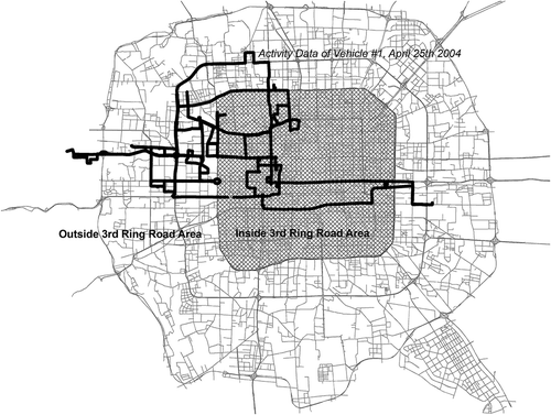
illustrates how the vehicle activity data are divided. The shaded area is “Inside 3rd Ring Road Area,” which is the downtown in Beijing, whereas the other urban area of Beijing is “Outside 3rd Ring Road Area,” which is the area outside the downtown. The average intersection density in the Inside 3rd Ring Road Area is about 17.4% higher than that in the Outside 3rd Ring Road Area. The black spots are vehicle activity data. Only the data of one vehicle collected on April 25, 2004, are displayed here for the convenience of illustration.
Figure 2. Area division of Beijing roadway network and example of vehicle activity data.
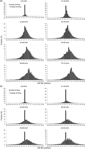
For each area group, the facility- and speed-specific VSP distributions are developed employing the VSP binning method described in the front. illustrates the VSP distributions and the 90% confidence intervals of the area groups of Inside 3rd Ring Area and Outside 3rd Ring Area in eight speed intervals on the expressway and in six speed intervals on the non-expressway. It is observed that the facility- and speed-specific VSP distributions are spatially consistent. A quantitative consistency analysis will be presented later.
Figure 3. Facility- and speed-specific VSP distributions of different areas (a) on expressway and (b) on non-expressway.
Results and discussion
Temporal and spatial consistency of VSP distribution
In order to quantify the differences between the facility- and speed-specific VSP distributions in different years and in different areas, the indicator of RMSE is employed. A higher value of RMSE means a higher level of difference between two VSP distributions. The RMSE is calculated using eq 4.
where RMSEA,B is the RMSE of VSP distribution A and B; is the fraction of the ith VSP bin in VSP distribution A;
is the fraction of the ith VSP bin in VSP distribution B; and n is the number of VSP bins in each VSP distribution, which is 41 in this study.
illustrates the RMSEs of the VSP distributions between different years and between different areas on the expressway and non-expressway. The RMSEs of the VSP distributions between different road types are illustrated as a reference of comparison.
Figure 4. RMSE of VSP distributions between different years, areas, and road types.
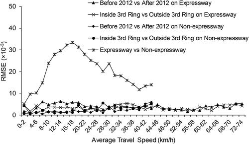
As can be seen, the RMSEs of the VSP distributions between different years and between different areas are significantly lower than those between different road types. The maximum RMSE between the VSP distributions of different years is 6.3 × 10⁻³ (3.7 × 10⁻³ on average) on the expressway and 5.9 × 10⁻³ (2.1 × 10⁻³ on average) on the non-expressway. The maximum RMSE between different areas is 5.3 × 10⁻³ (3.4 × 10⁻³ on average) on the expressway and 5.5 × 10⁻³ (2.7 × 10⁻³ on average) on the non-expressway, whereas that between the VSP distributions of different road type is as high as 33.4 × 10⁻³ (20.2 × 10⁻³ on average).
Impact of temporal and spatial differences of VSP distributions on emission estimation
In order to evaluate the impact of the temporal and spatial differences of the facility- and speed-specific VSP distributions on the emission estimation, the emission factors of CO2 for a specific vehicle type are calculated. Emission factor is defined as the vehicle emission per unit distance. In VSP-based microscopic emission models, it is calculated by multiplying the emission rate by the corresponding VSP distribution, as shown in eq 5 (Song et al., Citation2009). For a specific vehicle type, the emission rate in each VSP bin is fixed, all the differences of the emission factors are caused by the differences of the VSP distributions of different years and different areas.
where EFv is the emission factor in the average travel speed of v (km/hr), in unit of g/km; ERi is the average emission rate of the ith VSP bin in the unit of g/sec; VSP bini is the time fraction of the ith VSP bin.
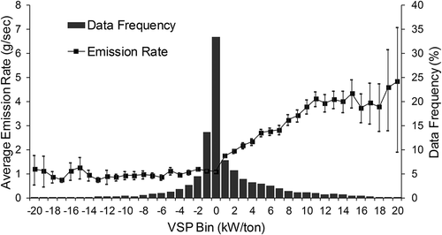
The average emission rate of CO2 in each VSP bin is developed using the vehicle emission data, which have been introduced above. The emission rate in each VSP bin, the 90% confidence interval, and the data frequency are illustrated in .
Figure 5. Average emission rate and data frequency in each VSP bin.
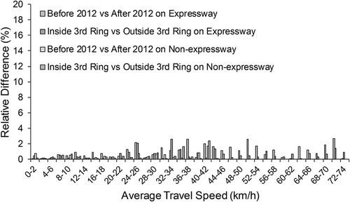
The emission factors of CO2 in each year group and each area group are calculated by using eq 5. illustrates the absolute value of the relative differences (%) of the CO2 emission factors between different years and between different areas. As can be seen, between different years, the maximum of the relative difference of the CO2 emission factors is 2.7% (1.0% on average) on the expressway and 1.7% (0.3% on average) on the non-expressway. Between different areas, it is 2.6% (0.6% on average) on the expressway and 2.4% (0.4% on average) on the non-expressway.
Figure 6. Relative differences of CO2 emission factors between different years and between different areas.
The maximum relative differences of the emissions caused by year difference and area difference are less than 3%. Since the emission rate in each VSP bin is fixed in this study, all the differences of the CO2 emission could be explained with the differences of the VSP distributions. It is indicated that the temporal and spatial differences of the VSP distributions have no significant impact on vehicle emission estimation. Therefore, it implies:
It is unnecessary to update the database of the VSP distributions in the emission model regularly.
It is feasible to use the facility- and speed-specific VSP distribution developed in one area to represent the vehicle operating mode in other areas for emission estimation of LDVs.
The methodology to calculate each of the pollutants is the same in the VSP-based model. CO2 was chosen to evaluate the impact of the temporal and spatial differences of the facility- and speed-specific VSP distributions on the emission estimation in this study. The comparisons of hydrocarbon (HC), carbon monoxide (CO), and nitrogen oxides (NOx) indicate that the maximum relative differences of the emissions caused by year difference and area difference are less than 5%. They were not illustrated because of the limited length of the paper.
Summary
This study develops the facility- and speed-specific VSP distributions in different years and in different areas in Beijing. The RMSE is employed to quantify the temporal and spatial differences of the VSP distributions. The emission factor of CO2 is calculated to evaluate the impact on vehicle emission estimation. Main findings are summarized as follows:
The characteristics of the facility- and speed-specific VSP distributions are highly consistent temporally and spatially. The case study in Beijing shows that the maximum differences of the VSP distributions between different years and between different areas are approximately 20% of that between different road types.
The temporal and spatial differences of the facility- and speed-specific VSP distributions have no significant impact on vehicle emission estimation, with relative difference of less than 3% on CO2.
The study in Beijing implies that it is unnecessary to update the database of the VSP distributions regularly within 10 years for developing regional emission inventory. And it is feasible to use the facility- and speed-specific VSP distributions developed in one area to represent the vehicle operating mode in other areas for emission estimation for LDVs.
VSP distribution is a critical parameter in vehicle emission estimation. This paper focuses on the temporal and spatial consistency of the VSP distributions. It is recommended that other factors that may affect the consistency of VSP distributions, such as driver’s aggressiveness and vehicle load, should be further investigated for the purpose of emission estimation.
Funding
This research is supported by the Natural Science Foundation of China (NSFC) nos. 51578052 and 51678045, and the Fundamental Research Funds for the Central Universities no. 2016JBM032.
Additional information
Funding
Notes on contributors
Zhiqiang Zhai
Zhiqiang Zhai is a Ph.D. candidate at the MOE Key Laboratory for Urban Transportation Complex Systems Theory and Technology, Beijing Jiaotong University, in Beijing, People’s Republic of China.
Guohua Song
Guohua Song is a professor at the MOE Key Laboratory for Urban Transportation Complex Systems Theory and Technology, Beijing Jiaotong University, in Beijing, People’s Republic of China.
Hongyu Lu
Hongyu Lu is a graduate research assistant at the MOE Key Laboratory for Urban Transportation Complex Systems Theory and Technology, Beijing Jiaotong University, in Beijing, People’s Republic of China.
Weinan He
Weinan He is an engineer at the Project Manager-Assessment and Modelling, Beijing Transport Energy & Environment Center, in Beijing, People’s Republic of China.
Lei Yu
Lei Yu is a professor at the College of Science, Engineering and Technology, Texas Southern University, in Houston, Texas, USA; and the Yangtze River Scholar of Beijing Jiaotong University, in Beijing, People’s Republic of China.
References
- Cadle, S.H., A. Ayala, K.N. Black, R.R. Graze, J. Koupal, F. Minassian, H.B. Murray, M. Natarajan, C.J. Tennant, and D.R. Lawson. 2008. Real-world vehicle emissions: A summary of the Seventeenth Coordinating Research Council on Road Vehicle Emissions Workshop. J. Air Waste Manage. Assoc. 58:3–11. doi:10.3155/1047-3289.58.1.3
- Chamberlin, R., B.A. Holmén, E. Talbot, and K. Sentoff. 2013. Comparative analysis of the EPA Operating Mode Generator with real world operating mode data. Paper presented at 92nd Annual Meeting January 2013.
- Davis, N., J. Lents, M. Osses, N. Nikkila, and M. Barth. 2005. Part 3: Developing countries: Development and application of an international vehicle emissions model. Transp. Res. Rec. 1939:155–65. doi:10.3141/1939-18
- Frey, H., N. Rouphail, and H. Zhai. 2006. Speed- and facility-specific emission estimates for on-road light-duty vehicles on the basis of real-world speed profiles. Transp. Res. Rec. 1987:128–37. doi:10.3141/1987-14
- Jiménez-Palacios, J.L. 1999. Understanding and Quantifying Motor Vehicle Emissions with Vehicle Specific Power and TILDAS Remote Sensing. Ph.D. thesis. Cambridge, MA: Massachusetts Institute of Technology.
- Ministry of Housing and Urban-rural Development of China. 2012. Industry Standard of the People’s Republic of China: Code for Design of Urban Road Engineering, CJJ37-2012. Retrieved from http://www.mohurd.gov.cn/wjfb/201607/t20160712_228082.html.
- Song, G., and L. Yu. 2009. Estimation of fuel efficiency of road traffic by characterization of vehicle-specific power and speed based on floating car data. Transp. Res. Rec. 2139:11–20. doi:10.3141/2139-02
- Song, G., L. Yu, and Z. Geng. 2015. Optimization of Wiedemann and Fritzsche car-following models for emission estimation. Transp. Res. Part D Transp. Environ. 34:318–29. doi:10.1016/j.trd.2014.11.023
- Song, G., L. Yu, and Z. Tu. 2012. Distribution characteristics of vehicle-specific power on urban restricted-access roadways. J. Transp. Eng. 138:202–9. doi:10.1061/(ASCE)TE.1943-5436.0000318
- Song, G., L. Yu, and Z. Wang. 2009. Aggregate fuel consumption model of light-duty vehicles for evaluating effectiveness of traffic management strategies on fuels. J. Transp. Eng. 135:611–8. doi:10.1061/(ASCE)TE.1943-5436.0000037
- Talbot, E., R. Chamberlin, A. Holmén, and K. Sentoff. 2014. Calibrating a traffic microsimulation model to real-world operating mode distributions. Paper presented at 93rd Annual Meeting of the Transportation Research Board, Washington, D.C., January 2014.
- U.S. Environmental Protection Agency. 2002. Methodology for Developing Modal Emission Rates for EPA’s Multi-Scale Motor Vehicle & Equipment Emission System. EPA420-R-02-027. Washington, DC: U.S. Environmental Protection Agency.
- U.S. Environmental Protection Agency. 2010. MOVES2010 Highway Vehicle Population and Activity Data. EPA-420-R-10-026. Washington, DC: Office of Transportation and Air Quality, U.S. Environmental Protection Agency.
- U.S. Environmental Protection Agency. 2011. Development of Emission Rates for Light-Duty Vehicles in the Motor Vehicle Emissions Simulator (MOVES2010). EPA-420-R-11-011. Washington, DC: U.S. Environmental Protection Agency.
- Wang, H., and L. Fu. 2010. Developing a high-resolution vehicular emission inventory by integrating an emission model and a traffic model: Part 1—Modeling fuel consumption and emissions based on speed and vehicle-specific power. J. Air Waste Manage. Assoc. 60:1463–70. doi:10.3155/1047-3289.60.12.1463
- Wang, H., L. Fu, and J. Chen. 2010. Developing a high-resolution vehicular emission inventory by integrating an emission model and a traffic model: Part 2—A case study in Beijing. J. Air Waste Manage. Assoc. 60:1471–5. doi:10.3155/1047-3289.60.12.1471
- Wang, J., H.A. Rakha, and L. Yu. 2015. Operating mode distribution characteristics of different freeway weaving configurations and their effects on vehicular emissions. Paper presented at 94th Annual Meeting of the Transportation Research Board, Washington, D.C., January 2015.
- Yu, L., Z. Wang, F. Qiao, and Y. Qi. 2008. Approach to development and evaluation of driving cycles for classified roads based on vehicle emission characteristics. Transp. Res. Rec. 2058:58–67. doi:10.3141/2058-08
- Yu, L., X. Zhang, F. Qiao, and Y. Qi. 2010. Genetic algorithm-based approach to develop driving schedules to evaluate greenhouse gas emissions from light-duty vehicles. Transp. Res. Rec. 2191:166–73. doi: 10.3141/2191-21.