
ABSTRACT
Public transportation automatic fare collection (AFC) systems are able to continuously record large amounts of passenger travel information, providing massive, low-cost data for research on regulations pertaining to public transport. These data can be used not only to analyze characteristics of passengers’ trips but also to evaluate transport policies that promote a travel mode shift and emission reduction. In this study, models combining card, survey, and geographic information systems (GIS) data are established with a research focus on the private driving restriction policies being implemented in an ever-increasing number of cities. The study aims to evaluate the impact of these policies on the travel mode shift, as well as relevant carbon emission reductions. The private driving restriction policy implemented in Beijing is taken as an example. The impact of the restriction policy on the travel mode shift from cars to subways is analyzed through a model based on metro AFC data. The routing paths of these passengers are also analyzed based on the GIS method and on survey data, while associated carbon emission reductions are estimated. The analysis method used in this study can provide reference for the application of big data in evaluating transport policies.
Implications: Motor vehicles have become the most prevalent source of emissions and subsequently air pollution within Chinese cities. The evaluation of the effects of driving restriction policies on the travel mode shift and vehicle emissions will be useful for other cities in the future. Transport big data, playing an important support role in estimating the travel mode shift and emission reduction considered, can help related departments to estimate the effects of traffic jam alleviation and environment improvement before the implementation of these restriction policies and provide a reference for relevant decisions.
Introduction
In recent years, the number of cars in most cities has been growing rapidly owing to the strong development momentum of the economy and the accelerated process of urbanization and mechanization. Traffic jams have become a social problem disturbing many large- and medium-sized cities. As an example, for Beijing, by the end of 2014, its capacity of motor vehicles reached 5.591 million (Beijing Transportation Research Center [BJTRC], Citation2015). In response to long-term problems disturbing both traffic and the environment, the Beijing government introduced driving restriction policies and motor vehicle purchase restriction policies in succession. Subsequently, driving restriction policy measures have been implemented to various degrees in 10 cities, including Lanzhou, Guiyang, Hangzhou, Tianjin, Chengdu, and others (Yang et al., Citation2014). China is not the only country using driving restriction policies. In Manila, a restriction scheme bans certain vehicles, identified by their license plate numbers, from using specified high-traffic arteries during peak hours (GTZ, Citation2002). Moreover, various major Latin American cities have implemented restrictive policies for private cars that prohibit their use on certain days based on their license plate numbers (Bull, Citation2003). In Managua, Nicaragua, restrictions in place since 2001 allow only half of the city’s taxi fleet to ply the streets during certain hours, in order to reduce congestion caused by the large number of existing vehicles. Cabs with even-numbered license plates numbers can circulate from 6 a.m. to 2 p.m., while those with odd-numbered plates are permitted from 2 to 10 p.m. (Grange and Troncoso, Citation2011). Vehicle restrictions have been implemented in a number of major cities as a regulatory policy for reducing congestion and air pollution. When confronted with major sports events, temporary traffic control is also used to ensure the reduction of traffic congestion. The 24th FIFA World Cup Matches and the 14th Asian Games (AG) were held in Busan, Korea, and the city attempted to reduce emissions from its fleet by reducing vehicle operation volumes during the two major sports event periods. Passenger vehicles were allowed to operate in Busan Metropolitan City areas only on alternate days during the FIFA World Cup in Busan during June 1–6, 2002 (Lee et al., Citation2005). As a subdivision of the Guangzhou, China, Asian Games, Foshan implemented temporary measures to limit motor vehicles in parts of the regions from December 26 to 29, 2009. The results showed that during the limitations, the main sections of road traffic fell by an average of 32.5%, and the proportion of different vehicle types changed greatly: Motorcycle traffic decreased significantly (Liu et al., Citation2010). To guarantee good traffic and air quality during the 16th Asian Games in Guangzhou, China, the government conducted two traffic control drills before the games and adopted traffic control measures during the games. Both the banning of high-emission vehicles and travel restrictions imposed by the use of odd–even licenses had significant effects on the reduction of vehicular emissions (Yao et al., Citation2013). Under these restriction policies, most car users can only choose to travel by public transport. The policies reduce the need and desire for private vehicle ownership to some extent and thus can massively reduce the amount of motorized travel (Barter and Raad, Citation2000). This shift in travel mode from high to low carbon emission not only can play a direct role in traffic alleviation, but also can reduce greenhouse gas emissions (Bhandari et al., Citation2014). Emission reductions in urban passenger transport have become important measures by which to achieve low-carbon development goals (Liu et al., Citation2015). Research on this travel mode shift and CO2 emission reduction promoted by the combination of restriction policies and public transport have important significance in guiding policies for reducing urban greenhouse gas emissions. Advanced data collection equipment provides new methods for research on travel mode shifts and policy evaluation.
The development of communication technology and the popularization of electronic equipment have brought revolutionary changes for methods of data collection and the magnitude of data accumulation. With the arrival of the concept of big data, the application of this field’s theory and technology has been discussed thoroughly (Pelletier et al., Citation2011). Without exception in the domain of transportation, technologies such as automatic fare collection (AFC), automatic vehicle location (AVL), and the global positioning system (GPS) have changed methods of data collection, accumulating vast amounts of data exceeding that collected by traditional methods (Ma and Wang, Citation2014). Big data in the transport field have provided new technical ideas for alleviating urban traffic jams, and transit agencies rely heavily on manual data collection methods to gather transit operation and planning data (Ma et al., Citation2012). In the domain of intelligent transport, the method of big data is mainly used in the fields of policy analysis and demand management. For example, Bagchi and White (Citation2005) pointed out that public transport integrated circuit (IC) cards had a wide range of coverage areas at that time, providing prospects for new data sources in making decisions about traffic planning; Blythe (Citation2006) analyzed the long-term trip habits of passengers based on the boarding place and travel time recorded in transport cards, providing suggestions on measurements for demand management and improving the appeal of public transport; Morency et al. (Citation2006) analyzed trip behaviors and usage patterns of different kinds of cardholders by applying the methods of data mining to data analysis of transport IC cards; Soda et al. (Citation2004) analyzed the charge policy based on the place of boarding and use frequency from card data. Effective data analysis results can help management to make better decisions. However, most analysis of transport card data at present is limited to passenger flow, trip rules, and characteristics of the public transport service itself, while there is less research focusing on macrolevel evaluation of transport policies.
In this study, with the subject of driving restriction policies, models are established to estimate the trip mode shift and CO2 emission reductions based on the combination of public transport AFC data and survey data. The evaluation of CO2 emission reductions in Beijing promoted by restriction policies is taken as an example. Transport big data, playing an important support role in estimating the travel mode shift and emission reduction considered in this study, can help related departments to estimate the effects of traffic jam alleviation and environment improvement before the implementation of these restriction policies and provide a reference for relevant decisions.
Background
Beijing was the first Chinese city to normalize driving restriction policies as a way of managing traffic. On September 28, 2008, the Beijing Traffic Management Bureau issued a “Notice on the Implementation of Traffic Management Measures,” which stated that from October 11, 2008, to January 10, 2009, automobiles in Beijing City (inside the fifth ring road) would cease traveling on public roads for one day per week according to the end number of the license plates of automobiles: Each day from Monday to Friday, automobiles with end numbers of 1 or 6, 2 or 7, 3 or 8, 4 or 9, and 5 or 0, sequentially, would cease traveling on public road spaces. License plates ending with English letters were categorized as end numbers of 0. The implementation of this policy has now been extended to April 9, 2017. This paper takes Beijing as a case to study the travel mode shifts and carbon emission reduction promoted by private driving restrictions.
Macro transport policies can be used to guide residents of a city toward shifting their trip modes (Lu and Gu, Citation2013), optimizing passenger transport structures and reducing transportation carbon emissions. Since driving restrictions have been implemented in many major cities, it is necessary to assess the carbon emissions reduction caused by this policy that could provide a data-level reference for reducing the greenhouse effect and improving air quality. Therefore, a quantitative method is needed to estimate the degree of change in trip modes and carbon emissions under these restriction policies. In recent years, scholars have conducted substantial research on CO2 emission reductions achieved by using public transport and traffic control.
Some scholars use the air monitoring equipment to test gas concentrations before and after traffic restriction. Lee et al. (Citation2005) studied the impacts on urban air quality of restricting the operation of passenger vehicles during the 24th Asian Games (AG) by analyzing the ambient concentrations of critical air compositions measured at 13 air-monitoring stations in Busan (Pusan), Korea. They found that the results strongly related to a change of meteorological conditions. Wang and Xie (Citation2010) applied the Operational Street Pollution Model (OSPM) to calculate the concentrations on urban streets in Beijing before and during the Olympic traffic control period in July 2008. The comparison of the calculation results in different types of street canyons reveals that the fleet composition and street geometry impact the concentration changes. These studies use monitoring data to evaluate gas concentrations before and after driving restrictions and could be affected easily by environmental conditions and the position of the monitoring equipment. Other studies have analyzed carbon emission reduction through traffic volumes. Yang et al. (Citation2014) predicted car trips of different periods a day after applying restrictions and adopted the TRANSTY 7-F model to calculate the carbon emissions on each road during peak hours and during the whole day. In the paper, the authors explained that the basic parameter in the model is traffic volume, which is the key factor that affecting the accuracy of the calculation. Liu et al. (Citation2010) used the European COPERT model to calculate vehicular emission factors, and the rate of vehicular emissions reduction was calculated according to traffic flow parameters including traffic volume, speed, proportion of different vehicle types, and vehicular emission factors. The traffic volume in this study was estimated from historical data and thus cannot be used to infer the details of individual choices.
Analyzing the shifts in traffic travel modes directly from AFC data to calculate CO2 emission reductions could avoid the interference of weather, monitoring equipment, and the error caused by the estimation of traffic volume. Therefore, this study proposes an estimation model based on big data from transport in combination with geographic information system (GIS) methods.
The mechanism behind travel mode shifts and carbon emission reductions resulting from driving restrictions is simple. Because of a restriction policy, private car users must choose turning to public transport, taking taxis, canceling unnecessary trips, and so on. The primary concern of policymakers is the degree to which car users turn to public transport, including the amount of the shift and the specific routing paths used. Based on the amount and routing paths, carbon emissions reduction can then be estimated through the comparison of carbon emissions with and without the restriction policy in place, as shown in .
Figure 1. Research scope regarding travel mode shift and emissions reduction.
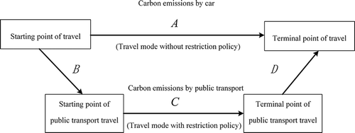
Three problems must be solved to evaluate the travel mode shift and emission reduction promoted by driving restriction policies. First, there is the question of how to get the number of passengers turning to public transport because of the restriction policy based on continuous historical AFC data; second, how to collect information about paths that passengers use in entering and leaving the public transport system, namely, sections B and D in ; and third, how to collect the complete trip path information for car users without the restriction policy in place, namely, section A in , as well as the public transport trip paths to which these drivers turn with the implementation of restriction policies, namely, section C in . A combination of AFC data, survey data, and the GIS method could extract hidden information and complete travel data to solve these problems.
Data and methodology
Smart card data
Since April 1, 2006, the AFC system has been applied in Beijing. By the end of 2015, the cumulative distribution of AFC card was close to 90 million (Beijing Municipal Traffic Card Co., Ltd., Citation2015). The AFC card has a number of preferential policies, and a half discount on buses, so almost covered every person living in Beijing. Therefore, trips extracted from the smart card data describe most of the situation.
This study draws on 10 consecutive weeks of smart card data provided by the Beijing Transport Committee. The data are stored in an Oracle database file. Each data record contains a unique line code and station code where boarding or alighting occurs, touch time, a card number, and card type. This information is crucial for data mining. Other information is also captured, such as card reader number, balance of the card, and so on.
Limited by the data available, measurements in this study contains only metro AFC data. This method is also applicable to the bus data, but unfortunately our study did not get this kind of data.
This study acquired metro AFC data during 10 consecutive weeks from October 13 to December 21, 2014, a period that contains 2.9 billion trips. Part of the original data is shown in . Since AFC data do not include information on routes, the path information is obtained by TransCAD in combination with AFC data.
Table 1. Smart card data-set sample.
In order to solve the three problems already mentioned, estimation models for the travel mode shift and carbon emission reduction under driving restrictions are established based on the combination of multiple data sources.
Methodology
Structure of the estimation model for carbon emissions reductions
Accurately estimating transport CO2 emission is an important task and can be tackled using one of two main approaches (Ma et al., Citation2014). The first is to estimate CO2 emissions using aggregate data for total energy consumed or the size of the vehicle fleet and average kilometers traveled per vehicle (VKT), which is called the “top-down” approach. However, application of this approach at the urban scale is often constrained by poor data, particularly a lack of reliable data on the vehicle fleet in the city, its city-wide energy use, and the average distance traveled per vehicle (He et al., Citation2013). In contrast, the second approach, the “bottom-up” method, is to estimate emissions from fewer aggregate travel attributes, including trip frequency, mode choice, and vehicle kilometers traveled for each trip (He et al., Citation2013).
According to the mechanism of emission reduction promoted by driving restriction policies and the practicality of data acquisition, our estimation model for carbon emissions reduction under driving restriction policies is established using a bottom-up approach based on the CO2 emission factor, trip distance, and travel frequency of different travel modes:
where is the CO2 emissions reduction brought about by travel mode shifts under driving restriction policies;
is the number of travel mode shifts from cars to public transport;
is the CO2 emission factor of cars (g CO2/Pkm);
is the single trip distribution of car users (km);
is the trip distance of different sections of a public transport journey (km), where i is B, C, and D, corresponding respectively to sections B, C, and D in ; and
is the carbon emission factor of the travel mode selected by passengers in section i (g CO2/Pkm).
As the measurement of the carbon emission factor is not the key point in this study, the value of the factor is taken from a relevant reference (Wang et al., Citation2015). Ntr and Lc can be acquired based on the mass of continuous AFC data, while Lcar, LB, and LD can be inferred by sampling supplementary survey data. The acquisition of each parameter is described in the following in detail.
Measurement of travel mode shifts
Before the application of intelligent data collection technology, shifts in travel mode could be measured generally by sample surveys, which consumed considerable equipment and financial resources. Big data available through public transport cards have significantly improved the statistical efficiency. By mining long-term historical data from public transport cards according to trip regulations, prediction of passengers turning to public transport because of driving restriction policies can be obtained while avoiding the deviation produced by sample surveys. The travel mode shift under a restriction policy can be discerned by the following steps, as shown in .
Step 1: Assuming each public transport card number represents one passenger, a group of passengers represented by card numbers can be established by gathering card numbers from AFC data.
Step 2: Look up all travel records of each passenger over an entire registration period, beginning with the first card number. Judge whether the number of travel days is equal to 1 during the weekdays in a single week. If yes, then go to step 3; if not, return to step 2 and look up the next passenger.
Step 3: Check the travel records of the passenger over several weeks. If the passenger used public transport on the same days during each week, then go to step 4; otherwise, return to step 2.
Step 4: Gather the card numbers meeting the conditions necessary to establish a collection of travel mode shift passengers.
Figure 2. Selection process for trip mode shift passengers.
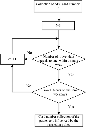
Finally, the card number collection established in step 4 can be assumed to contain passengers whose travel modes shifted from cars to public transport. The number of passengers in the collection is Ntr.
Using this method and the selection of AFC data, the number of travel mode shift passengers Ntr is 17,317 in a single week, and the travel frequency is 28,932. The origin–destination (OD) stations of each trip could be extracted from the AFC card records, and the trip distance LC of each passenger in the public transport system can be calculated by establishing a transport network and allocating specific routing paths. The method of routing path allocation is introduced in detail later.
Questionnaire processing
Carbon emission levels change in different ways as passengers enter and leave public transport. Calculating this part of carbon emissions requires the travel mode and the starting and terminal points chosen by passengers in sections B and D in . These data could be obtained through questionnaires. Then the travel distance corresponding to each passenger can be calculated by combining this information with routing path allocation. The starting and terminal points of the private car travel mode can also be determined by questionnaires. The questionnaires include the following aspects:
The starting and terminal points (e.g., name of area, name of place of work, etc.), and the origin and destination public transport stations for a specific trip.
The transport mode that passengers choose to travel to the public transport station, the transport mode that passengers choose to travel to their destination after leaving the station, and the specific information for this mode.
Before the operation of the metro line, passengers use which kind of modes for travel? If they use private car to travel, ask for the fuel consumption per 100 km and the passenger loading rate of their private cars.
Samples, the basis for statistical inference, must be representative in order to reflect general characteristics. With assurance of both reliability and accuracy expected for sample inference, a proper sample size can be calculated using eq 2:
where is the minimum sample size, N is the total capacity, t is the degree of probability,
is the standard deviation of samples, and
is the limit error of the sample mean value.
Preliminary research on subway passengers in Beijing was conducted in April 2015, for which the total numbers of questionnaires and valid questionnaires were 55 and 51, respectively. The standard deviation, , of the samples in the preliminary research was 11.3. Applying statistical methods to AFC historical data shows the number of people traveling by subway in a single week to be 6.8 million. The required reliability of the sample inference was 95%, and the permissible error was not more than 5%. The minimum size of the sample survey was 1,962 according to eq 2.
Subway lines 6, 8, and 9 were selected as subjects in this study because of their short service time. First, sample size was allocated based on the passenger flows at each station. Then, sample sizes during different time intervals within a single day were confirmed according to the characteristics of passenger flows in the mean and peak hours. The total number of valid questionnaires collected from all metro lines was 2,002, meeting the requirements of minimum sample size, as shown in .
Table 2. Sample size.
In order to ensure the accuracy of the survey data, the observed average operation distances of 8.05 km, 7.40 km, and 6.38 km for lines 6, 8, and 9, respectively, were compared with the 2014 data from the Beijing Mass Transit Railway Operation Co. Ltd. The error of the comparison is about 4.6%, indicating an acceptable accuracy in this survey.
Travel path acquisition
Calculating the carbon emissions requires the distance of passengers’ trips. Travel distance couldn’t be obtained directly from the survey questionnaire, and AFC data don’t record passengers’ specific routes. But these two kinds of data both contain the departure and the arrival point of the passenger travel, and the following method can help to get the trip distance. In this study, travel routing paths were allocated by TransCAD. TransCAD is a geographic information system (GIS) designed to store, display, manage, and analyze transportation data. TransCAD provides application modules for routing that help us calculate travel distance. First, create a transport network consisting of nodes and edges using geographic data of road network; second, calculate the travel time of each section on the network by the BPR method, and the punishment time depends on the complexity of the road network; third, import the locations of the origin and destination of each passenger trip and assign a specific route for it. Then the travel distance is obtained.
The U.S. Bureau of Public Roads (BPR) function is used to describe the relationship between the travel cost (or time) of the vehicle on the road and the road traffic condition. It can reflect the traffic capacity restriction and crowding effect of each component of the road network and is the prerequisite for the traffic allocation. Equation 3 is the BPR function:
where is travel time in the section in units of hours;
is travel time in noncrowded conditions in units of hours;
is passenger flow in the section in units of number of people;
is traffic capacity of the section in units of number of people; and
and
are calibration coefficients, which are generally equal to 0.15 and 4.0, respectively.
The model of allocation in the third step is shown next (Si et al., Citation2007):
where is the passenger flow in the mth routing path between the ith OD pair and
is the total number trips between the
th OD pair;
is the relationship between the routing paths and sections. If section i is in the mth routing path between the
th OD pair, the value of
is equal to 1; if not, it is equal to 0. The term
is a nonnegative parameter describing the random characteristics of the whole model. The larger the value of
, the more accurate is the understanding of the generalized path cost by passengers. The term
, the sum of travel time and punishment time in a section, is the generalized cost of the ith section in the road network.
The parameter values in the model of allocation are shown in (Beijing Mass Transit Railway [MTR] Corporation Limited, Citation2007).
Table 3. Related parameter values. (Beijing MTR Corporation Limited, Citation2007).
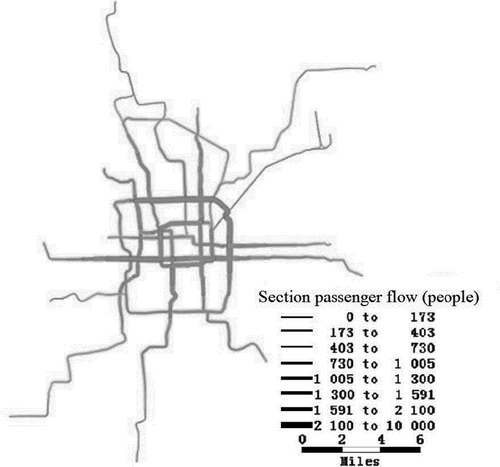
The results of passenger flow assignment in the rail transit network are shown in . The passenger flow in the rail transit section is presented in .
Table 4. Passenger flow in the rail transit section.
Figure 3. Results of passenger flow assignment in the rail transit network.
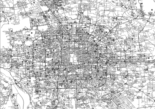
For the passengers who used to travel by car before the opening of metro lines, the starting and terminal locations of their trips were calibrated by GIS software, as shown in . The travel distance can be calculated after the allocation of routing paths. A sample average of 29.13 km was taken as the travel distance in a single car trip for these passengers. The travel distances of passengers in sections B and D in were derived using the same method. At this point, all the parameters in the model have been measured.
Figure 4. Sample data for car trip OD calibration.
Results and discussion
Travel mode shifts
Travel information collected from the AFC data showed that total trips of the metro network during weekdays is about 23 million every week, and trips shifted from private cars to metro is 28,932, accounting for 0.12% . The average travel distance of these passengers is 29.13 km, which means that the metro is favored by medium- and long-distance travel passengers. Other restricted passengers whose travel distance is shorter are more inclined to choose bus or taxi.
According to the survey data, 85% of passengers chose to walk or ride to enter and leave the metro system, indicating that the subway station planning is reasonable to directly meet the travel needs of passengers. There are lots of commuter passengers who take the initiative to shift from private car to metro after a new metro line starts operation, even on unrestricted days, because travel by metro is more convenient and punctual. This shows that if the public transport service is reasonably planned according to passenger demand, it will indeed help to attract more passengers to public transport. In addition, some respondents said that the restrictions policy will not change their way of travel, because they have purchased a second car as the replacement car on restriction days.
Carbon emissions
Emission factors are key parameters used to calculate CO2 emission reductions. The 2006 Intergovernmental Panel on Climate Change (IPCC) Guidelines for National Greenhouse Gas Inventories provide lower calorific values, carbon emission factors, and carbon oxidation rates for different fossil fuels. However, in the preceding factors, reference experience overseas is not exactly the same as in China’s national conditions; therefore, this paper determined the Chinese emission factors from the literature (Wang et al., Citation2015). Different CO2 emission factors for different travel modes in Beijing are shown in .
Table 5. CO2 emission factors of different travel modes in Beijing (Wang et al., Citation2015).
Applying all of the parameters to eq 1, the CO2 emissions reductions of trips shifted from car to rail travel within a week under the driving restriction policy in Beijing are shown in . Taking into account the impact of season and statutory holidays, the implementation of driving restriction policy is about 46 weeks per year. The CO2 emissions reduction promoted by both the driving restriction policy and the availability of rail transit was 6,149.74 t.
Table 6. CO2 emissions reductions of trips shifted from car to rail travel within a week.
Conclusion
This study has established models evaluating travel mode shifts and CO2 emissions reductions under driving restriction policies. Based on metro AFC data, survey data, and the GIS method, Beijing’s travel mode shift and CO2 emissions reductions were measured as an example. We found that private driving restriction policies have important effects on traffic volume and vehicle emissions. The results of the study are summarized here.
1. Big data on transportation can be used to effectively evaluate macrolevel policies related to public transport. This evaluation represents a substantial exploration of transportation data, excluding analysis of passengers’ unique trip characteristics, promoting deep mining of transport data and allowing these data to reach their full potential in supporting effective policy making.
2. In Beijing, the total number of travel mode shift passengers under the driving restriction policy and the travel frequency in a single week were found to be 17,317 and 28,932, respectively. The average CO2 emissions reduction per week was 133.69 t. The average emissions reduction per year was 6,149.74 t.
The results outlined in the preceding show that the driving restriction policy led to an obvious CO2 emission reduction. According to the travel mode shift, the subway utilization rate of car users is not high, indicating a high comfort requirement of car users and thus a preference among these car users for taxis or uncrowded buses. In addition, the survey results show that the passenger load rate of cars on weekdays is low with an average of less than 1.5 occupants, indicating the need to promote proper car sharing behavior to alleviate traffic jams and reduce CO2 emissions.
Limited by the AFC data available, only passengers whose travel modes shifted to rail transit were measured in this study. If complete public transport data were to be acquired, a more accurate estimation of emissions reductions caused by driving restriction policies could be made and passengers’ preferences for other travel modes on restriction days could be analyzed further. In this way, the quality of public service can be improved and harmonious development of urban transport can be promoted.
Although there are some uncertainties in the estimated emissions reductions, the evaluation of the effects of driving restriction policies on the travel mode shift and vehicle emissions will be useful for other cities in the future.
Acknowledgment
The authors gratefully acknowledge the Beijing Transport Committee for providing the AFC data on ridership.
Funding
This work is supported by the National Natural Science Foundation of China (grant 51278029) and the Fundamental Research Funds for the Central Universities (grant 2016RC017).
Additional information
Funding
Notes on contributors
Wandi Zhang
Wandi Zhang is a Ph.D. candidate in the School of Civil Engineering at Beijing Jiaotong University in Beijing, People’s Republic of China.
Feng Chen
Feng Chen is a professor in the School of Civil Engineering at Beijing Jiaotong University in Beijing, People’s Republic of China.
Zijia Wang
Zijia Wang is a lecturer in the School of Civil Engineering at Beijing Jiaotong University in Beijing, People’s Republic of China.
Jianling Huang
Jianling Huang and Bo Wang are senior engineers at the Beijing Transportation Information Center.
Bo Wang
Jianling Huang and Bo Wang are senior engineers at the Beijing Transportation Information Center.
References
- Bagchi, M., and P.R. White. 2005. The potential of public transport smart card data. Transport Policy 12(5):464–74. doi:10.1016/j.tranpol.2005.06.008.
- Barter, A.R.P., and T. Raad. 2000. Taking steps—A community action guide to people-centred, equitable and sustainable urban transport. TRID TRB. https://trid.trb.org/view.aspx?id=666842.
- Bhandari, K., M. Advani, P. Parida, and S. Gangopadhyay. 2014. Consideration of access and egress trips in carbon footprint estimation of public transport trips: Case study of Delhi. J. Cleaner Product. 85:234–40. doi:10.1016/j.jclepro.2014.05.013.
- Blythe, P.T. 2006. Intelligent infrastructure: A smart future with smart dust and smart markets. Proceedings of IFAC Conference on Transport Automation and Control, Prishtina, Kosovo, June 15–17. doi:10.3182/20060829-3-NL-2908.00089
- Bull, A. 2003. Congestión de Tránsito: El Problema y Cómo Enfrentarlo. Comisión Económica para América Latina y el Caribe (CEPAL) and Deutsche Gesellschaft für Technische Zusammenarbelt (GTZ) GMBH. Santiago, Chile: Naciones Unidas.
- Beijing Mass Transit Railway (MTR) Corporation Limited. 2007. Beijing Metro Line 4 project clearing liquidation report. Beijing, China: Beijing Jiaotong University.
- Beijing Municipal Traffic Card Co., Ltd. 2015.Yikatong is brought into the community and the number of recharge outlets doubled. http://www.bmac.com.cn/hydt/2594.jhtml ( accessed August 14, 2015).
- Beijing Transportation Research Center. 2015 Beijing transport annual report. Beijing, China: Beijing Transportation Research Center.
- Grange, L.D., and R. Troncoso. 2011. Impacts of vehicle restrictions on urban transport flows: the case of Santiago, Chile. Transport Policy 18(6):862–9. doi:10.1016/j.tranpol.2011.06.001.
- He, D., H. Liu, K. He, F. Meng, Y. Jiang, M. Wang, J. Zhou, P. Calthorpe, J. Guo, Z. Yao, et al. 2013. Energy use of, and CO2 emissions from China’s urban passenger transportation sector—Carbon mitigation scenarios upon the transportation mode choices. Transport Res. A Pol. 53:53–67. doi:10.1016/j.tra.2013.06.004.
- Lee, B.K., N.Y. Jun, and H.K. Lee. 2005. Analysis of impacts on urban air quality by restricting the operation of passenger vehicles during Asian Game events in Busan, Korea. Atmos. Environ. 39(12):2323–38. doi:10.1016/j.atmosenv.2004.11.044.
- Liu X., S. Ma, J. Tian, N. Jia, and G. Li. 2015. A system dynamics approach to scenario analysis for urban passenger transport energy consumption and CO2 emissions: A case study of Beijing. Energy Policy 85:253–70. doi:10.1016/j.enpol.2015.06.007.
- Liu, Y., S. Bi, B. Zhou, C. Wang, H. Liao, L. Li, and M. Cai. 2010. Study on vehicular emission reduction effect of traffic control in Foshan central district. China Environ. Sci. 30(11):1567.
- Lu, X., and Y. Gu. 2013. Strategic significance and critical role of transportation policy: Implementing “Shanghai Metropolitan Transport White Paper” in the past 15 years. Urban Transport China 5:12–7. doi:10.3969/j.issn.1672-5328.2013.05.006.
- Ma, J., A. Heppenstall, K. Harland, and G. Mitchell,,2014. Synthesising carbon emission for mega-cities: A static spatial microsimulation of transport CO2 from urban travel in Beijing. Comput. Environ. Urban 45(45):78–88. doi:10.1016/j.compenvurbsys.2014.02.006.
- Ma, X., Y. Wang, F. Chen, and J. Liu. 2012. Transit smart card data mining for passenger origin information extraction. J. Zhejiang Univ.-Sc. C 13(10):750–60. doi:10.1631/jzus.C12a0049.
- Ma, X., and Y. Wang. 2014. Development of a data-driven platform for transit performance measures using smart card and GPS data. J. Transp. Eng. 140(12):04014063. doi:10.1061/(ASCE)TE.1943-5436.0000714.
- Morency, C., M. Trepanier, and B. Agard. 2006. Analysing the variability of transit users behaviour with smart card data. Presnted at 2006 IEEE Intelligent Transportation Systems Conference, IEEE, Toronto, Ontario, Canada, September 17–20.
- Pelletier, M.P., M. Trépanier, and C. Morency. 2011. Smart card data use in public transit: A literature review. Transp. Res. C 19(4):557–68. doi:10.1016/j.trc.2010.12.003.
- Si, B., B. Mao, and Z. Liu. 2007. Passenger flow assignment model and algorithm for urban railway traffic network under the condition of seamless transfer. J. China Railway Soc. 29(6):12–8. doi:10.3321/j.issn:1001-8360.2007.06.003.
- Soda, H., N. Fujii, K. Utsunomiya, Y.Miyazawa, and T. Koyama. 2004. A study on historical trend of fare of tram systems and right to transport of passengers. Rev. Assoc. Droit Transport 21:89–99.
- The Deutsche Gesellschaft für Technische Zusammenarbeit (GTZ). 2002. Transport demand management: Towards an integrated approach. Paper presented at Regional Workshop on Transport Planning, Demand Management and Air Quality, Manila, The Philippines, February 26–27, 2002.
- Wang, T., and S. Xie. 2010. Modeling the vehicle pollution in the urban streets before and during the Beijing Olympic Games Traffic Control Period. Chin. J. Environ. Sci. 31(3):566–72.
- Wang, Z., F. Chen, and T. Fujiyama. 2015. Carbon emission from urban passenger transportation in Beijing. Transp. Res. D 41:217–27. doi:10.1016/j.trd.2015.10.001.
- Yang, H., H. Ding, and G. Li. 2014. Calculation of carbon emission of urban districts during vehicle restriction by tail number. J. Gansu Sci. 26(6):142–5. doi:10.3969/j.issn.1004-0366.2014.06.033.
- Yao, Z., Y. Zhang, X. Shen, X. Wang, Y. Wu, and K. He, 2013. Impacts of temporary traffic control measures on vehicular emissions during the Asian Games in Guangzhou, China. J. Air Waste Manage. Assoc. 63(1):11–9. doi:10.1080/10962247.2012.724041.