
Abstract
The Model of Participatory Zoning was developed by the Cartographic Laboratory Diathesis at the University of Bergamo (Italy) and was applied in the framework of Program Régional Parc W/ECOPAS (Ecosystèmes Protégés en Afrique Sahélienne). This model establishes a specific research methodology and develops some GIS (geographic information system)-based analytical tools. The research team designed these analytical tools in order to employ environmental protection models in the field research, which are based on sustainable development and participative management (UNESCO's Man and the Biosphere (MAB) zoning model). The Model of Participatory Zoning, based on participatory mapping that includes geographical competence in applied research, allows the transformation of theoretical concepts into management tools, that is, it embraces all project management phases, from methodological design to the digital capitalization of the outcomes achieved. This model considers territory not merely as something that conveys the material conditions of the humans who settled there, but also as something that embodies symbolic, cultural, and communal values, on which the functioning of any given society depends. For these reasons, maps must be approached with attention to cartographical semiosis, a theory whereby the drawing of a map must not be separated from an analysis of the territory since maps act as symbolic agents for a given society, that is, they prescribe the conditions for any territorial action. Far from being only a useful representational tool, maps, and in particular participatory maps, set out the place where the viewpoints of institutional agents – who are appointed to plan environmental and territorial conservation – are brought into question and placed side by side with those of local actors – who employ specific territorial knowledge either to promote or hinder conservation.
Introduction
The present study advocates a strategy aimed at implementing the principles of sustainable development through operational tools used in programs for environmental conservation.Footnote1 To be more precise, I outline a proposal for participatory zoning that is innovative in two main respects: (i) it is based on an assessment of the territorial setup and the social values of the people who inhabit the peripheries of parks; (ii) it is represented through customized geographic information system (GIS) cartography.
As a matter of fact, cartography and field research are seen as two complementary phases which provide both theoretical reflection and practical application when ordinary criteria in the zoning of park peripheries are challenged. The new zoning criteria rely on the recovery of the territorial perception of local communities whose consensus on plans for environmental conservation is thus ensured. In sum, I advocate a zoning model that may prevent conflict between local communities and international agents, while also promoting development of the former (Casti & Marino, Citation1997; Chambers, Citation1983; Ford, Lelo, & Thomas-Slayter, Citation2001; Pretty, Guijt, Scoones, & Thompson, Citation1995).Footnote2
This zoning model is the result of new theoretical approaches that show how a given territory may be used together with its local systems of representation, in order to examine and understand the functioning of a social group (Casti, Citation2000; Turco, Citation1986, Citation1988).Footnote3 Yet this model is not merely theoretical, as its pragmatic value has been demonstrated within the Ecosystèmes Protégés en Afrique Sahélienne (ECOPAS) program in a specific territorial context – the peripheries of the transboundary W Park (Benin, Niger, Burkina Faso) – where it has proven effective.
Cartography: a milestone in cooperation
My zoning model sees territory as the result of a dynamic interaction between the natural environment and the people who inhabit it (see Turco, Citation1988). One cannot fail to consider this if one admits that the notion of territory does not merely convey the material conditions of the humans who settle there but also embodies symbolic, cultural, and communal values, on which the functioning of any given society depends (Bonnemaison, Cambrezy, & Quinty-Bourgeois, Citation1999; Brace, Citation2002; Thual, Citation1999; Turco, Citation2001).Footnote4 This is all the more relevant in specific contexts, such as the African one, where black settlements along the peripheries of parks, removed as they are from urban areas, are still largely based on a traditional system of cosmogonic rules bearing primarily upon territory and the rights to own land, to hunt, or to farm. Hence the need to carry out field research in ways that may effectively account for such complex variables, rather than focusing exclusively on the set of material data which cartographic reconstruction ordinarily employs.
For the present purposes, cartographical theory must be approached with an eye on cartographical semiosis, a theory whereby the drawing of a map must not be severed from an analysis of territory, for maps act as mediatory agents between a given society and its territory. Emphasis is thus shifted from the role of maps as descriptive items to the role of maps as prescriptive operators whose self-referential sets of information effectively impinge upon territorial intervention. In this view, maps address the complexity of geographical space by arranging it within a controlled cartographical space on the basis of which action is determined (Mac Eachren, Citation1995; Wood, Citation1992).Footnote5
Without doubt, cartographical semiosis differs from cartographical studies still rooted in scientific positivism where analysis was centered upon the technical, structural aspects of maps and on what maps purported to represent. Those studies only served to sanction the presumed or claimed objectivity of cartographical maps. Since the idea of maps as objective mirrors of reality was abandoned, maps have been regarded as evidence of intellectual appropriation on the part of humans who aimed at establishing their rule over parts of the world. Moreover, a cartographical map can now be seen both as a social product, which shows how a given society builds its own system of territorial knowledge, and as a means of communication whereby this knowledge is circulated, a sort of operator which influences those who interpret it and affects decisions (Casti, Citation2005; Farinelli, Citation1992; Harley, Citation1992; Jacob, Citation1992).Footnote6 This perspective reclaims both the constructive and communicative aspect of maps, and emphasis is shifted from what maps represent to what they convey about the deep meaning of territory.
In light of this current interpretative approach, maps nowadays figure as highly performative tools in data processing, both at the regional and local levels; tools that can yield new territorial perspectives. It should be noted that I do not primarily aim to provide specific referential information of the kind found in topographic maps: I set out to recover social data that may bring to the fore the complexity of territory. In fact, studies carried out within specific cartographic fields – such as GIS cartography or graph-based planning – demonstrate that new communicative options open up once strict encoding rules are left behind (Debarbieux & Lardon, Citation2003; Söderstrom, Citation2000).Footnote7 Moreover, cartography is thus allowed to address a variety of different needs ranging from visualization, readability, and communication to time projections and concertation. Far from being only a useful representational tool, cartography sets up the context in which the viewpoints of institutional agents – who are appointed to plan environmental or territorial conservation – are brought into question and set side by side with those of local operators – who employ specific territorial knowledge to promote or hinder conservation.
What was left to consider was how all of this could translate into a cartographical model capable of outperforming topographic representation by accounting for the social value of territory in territorial planning. For the relevance of theory also depends on whether it lets us act proficiently upon forthcoming documentation and whether it lets us deliberately qualify the information maps convey. Distortions that may result from producing or using maps unwittingly – together with the misleading or blatantly deceptive readings of territory that ensue – may thus be avoided (Casti, Citation2001b, Citation2003, Citation2004).Footnote8 Hence the political relevance of the plan map, from which local communities and appointed agents draw their institutional legitimacy (Lévy, Citation2008; Lévy, Poncet, & Tricoire, Citation2004).Footnote9
Field research and cartographical methods
My research experience at the peripheries of W Park was developed on the basis of my new approach to cartography outlined above. My researchers and I first tried to recover the identity and the communal values of the African people through a socio-territorial analysis aimed at laying out a cartography of peripheries within an extensive conservation area – the transboundary W Park that crosses the borders of Benin, Niger, and Burkina Faso.Footnote10 In the course of this research I found that in order to produce a reflexive cartography, with regard to the social value of territory, we needed to invest heavily in each of the research phases. Namely:
it was crucial that information on the social meaning of territory should appear on the map;
such information had to be symbolically encoded in ways that reclaimed the social values of the people who inhabited that territory;
the map had to convey the socio-territorial setup by featuring its social practices;
in order to achieve cumulative data integration, it was necessary to work at both scales (regional and local);
the adoption of the map in planning had to account for the results of cartographic communication as highlighted through semiotic studies (self-reference and iconization).
The field research was conducted over a total period of 12 months and for three drought seasons by a joint team of researchers from Northern and Southern institutions (University of Bergamo, Italy; University of Cotonou, Benin; University of Niamey, Niger; University of Ouagadougou, Burkina Faso) who had previously been trained in the methods and theory used in this research. Since the pieces of information to be collected had to reflect social practices, they were necessarily recovered by direct observation of the territory and later collated within a thorough socio-territorial inquiry. Top priority was thus given to the recovery of basic issues and to an understanding of the symbolic values which underlie traditional communities. Taken together, these two phases make up the framework of cartographical information.
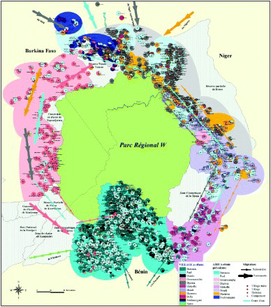
Collected data was processed via GIS software and yielded a cartographic representation in terms of knowledge-based zoning (Campbell & Masser, Citation1995; Goodchild, Citation2000; Longley, Goodchild, Maguire, & Rhind, Citation2011; Miller, Citation2003; National Center for Geographic Information Analysis [NCGIA], Citation1996; Pickles, Citation1995) on two different scales: regional and local.Footnote11 At the regional scale, specific knowledge from inhabitants and general knowledge of socio-territorial systems were put together. In addition, Western-based criteria (number of villages, population density, ongoing dynamics, etc.) were matched with African categories, which ultimately allowed a translation and revaluation of the basic values underlying territory. Regional maps served primarily to encode quantitative and qualitative data which gave us a measure of the dynamics at work in the areas analyzed and of the social phenomena that bring about change or ensure stability.Footnote12 Information thereby produced yielded a representation of the socio-territorial layout at the peripheries of the Park, and served, above all, to highlight change factors and to suggest plans and modes of intervention (& ).
Figure 1. An example of regional cartography that recovers the traditional setup of villages.
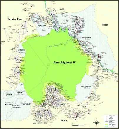
Figure 2. An example of regional cartography that shows migration flows.
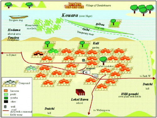
If we now turn to the other side of cartographic research, the participatory one, carried out in the same context on a local scale, we must keep in mind that it involved local people, actively called upon in the researching of communal practices: this established a common ground for a discussion of the measures for environmental conservation between the involved parties (IUCN & UNFPA, Citation1997).Footnote13 What we did in this case was to approach the participatory map in ways that could bring out new, relevant pieces of information (Casti & Yonkeu, Citation2009; FAO, Citation1994).Footnote14 For participatory maps are not invariably and purposefully used in planning and in cooperation: their communicative clues are often neglected in practice, instead of being used to voice the issues of populations who inhabit the Southern hemisphere. As a matter of fact, the mere adoption of a participatory map as a data-gathering tool does not ensure a true reassessment of the social values rooted in territory (Casti, Citation2001a).Footnote15 Conversely, an analysis of the semiotic potential of participatory maps shows how they can be used effectively to make sense of knowledge shared by local communities (see Burini, Citation2004). Participatory maps have proven particularly effective in the research field of environmental conservation, where they provide key information on the relationship between local settlements and their environment by shedding light on conventional practices of conservation and resource exploitation as conveyed in the symbolic values local inhabitants employ. What we kept in mind during this experience was essentially the evidence provided by cartographical semiosis, that is, the fact that the esthetic layout of a map may equally well turn out to be an aid or a hindrance, all the more so when we are dealing concurrently with different cultural contexts. Our participatory maps were processed using the language of analogy which – by virtue of its reliance on perceptual experience – has proven easier to understand (see Casti, Citation2013) (). Certainly, the readability of a map does not depend exclusively on its allowing perceptual experience, but also on the proficiency of local agents when gathering socio-territorial information and in interpreting it on the connotative, social level. Once again cartographical semiosis comes to the rescue in extracting and expressing features of maps that would otherwise have lain hidden; features that later helped to substantiate claims and corroborate knowledge as conservation was planned. In communicative terms, the tool of cartographical representation proved surprisingly effective at the very outset of research, as it helped researchers to give shape and sense to a plethora of collected data. Documentation thus produced was later used to come up with plans for cartography which proved unpredictably useful in participatory development programs (Harris & Weiner, Citation1998; Rundstrom, Citation1995; Talen, Citation2000).Footnote16 My first attempt in this phase was to use cartography as an information-generating tool to supplement field-research data (Casti, Citation2012b; Ghisalberti, Citation2011).Footnote17 On a regional scale, the map allows comparative analysis of a kind that would have been virtually impossible by relying only on endless lists of itemized data. On a local scale, the map highlights community values and knowledge, items that conventional methods of inquiry would have neglected. At the planning stage, interpretation of the new data collected by this cartography made it possible to formulate predictive assumptions about the effectiveness of my research model and its conservation project.
Figure 3. An example of participatory cartography that recovers the territorial organization of the local population.
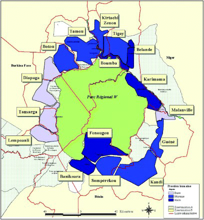
At a later stage, which could be defined as intervention zoning, I used previous results to conceive and set up a model of participatory zoning for the peripheries of W Park. This model is based on three main criteria: cohesion, which examines the extent to which territory is homogeneous, to make sure that the conservation project matches local issues; pressure, which takes into account the extent of human intervention with the natural resources to be preserved and gives us a measure of the urgency and priority of conservation planning; and lastly localization, which looks at how close or how distant human settlements are with respect to the Park's limits in order to come up with an index of anthropic persistence within the research area. These criteria were used to lay out three different zones: first-level units, established on the basis of socio-territorial cohesion; second-level units or sectors, defined on account of the cohesion or pressure exerted on natural resources; and a localizing frame, which depends on the distance of settlements from the park and protected areas. The final zoning map was obtained by integrating these three zone types ().
Figure 4. Cohesion and pressure of zoning sectors in the periphery of the W Regional Park.
The fourth research phase could be named contractual zoning. It is the pragmatic phase of co-management, where a zoning map – aimed at providing a practical management tool – is produced (Abrams, Borrini-Feyerabend, Gardner, & Heylings, Citation2003; Borrini-Feyerabend, Citation2003a, Citation2003b; Casti, Citation2012a; Pimbert, Citation2003; Pimbert & Wakeford, Citation2001).Footnote18 I proposed an innovative type of management based on the combined results of cartography and field research; a management which effectively boosted negotiations between the parties involved by making them aware of cartographical dynamics. Identity values, on the basis of which local communities establish their territorial setup, are thus used to devise a new model of participatory zoning on the peripheries of the protected area. Far from being merely a theoretical instrument, this model provides a valuable operational tool for participatory management and conflict prevention on park peripheries.
Conclusion
The model I propose here is intended to respond to the difficult task of finding methods and tools that can be used immediately in practice, so that planning may yield concrete results based on the thoughtful consideration of traditional socio-territorial systems, in compliance with the theoretical goals set up in policies of sustainable development. More precisely, on the basis of recent acquisitions in the fields of complex representation systems and new theoretical approaches to communication concerning the deep meaning of territory, I set out to develop a new conceptual model of reflexive cartography that can sensibly contribute to defining a participatory approach. This is achieved by marking territorial zones of intervention and by careful plans for a sustainable exploitation of resources and for a long-term participatory management of park peripheries. Zoning – already taken up as part of the ECOPAS program – shows the potential of cartography as a hypertext whereby poverty data is found, collected, and catalogued both by members of the scientific community and by agents involved in conservation. I submit the present research as evidence of its methodological value and its applicability to many other possible contexts.
Notes
1. This article is an extension of a conference paper presented at the International Conference on Nature, Bangkok, 2004. The author originally developed the cartographic theory and the research methodology presented, which was then tested by a team of researchers from the University of Bergamo (www.unibg.it/diathesis). The field research, specifically data collection activity – which was promoted, directed, and coordinated, also on-site, by the author – was carried out by both the research team of Bergamo University and African researchers (Université de Ouagadougou, Burkina Faso; Université Abdou Moumouni de Niamey, Niger; Université d'Abomey-Calavi, Cotonou, Benin). It was funded by the Scientific Coordination of PRPW/ECOPAS program (Centre CIRAD – Coopération Internationale en Recherche Agronomique pour le Développement in Montpellier) and lasted three years (2001–2004), during which local inhabitants were involved in the evaluation of their territory. This first research phase was followed by a second one (2004–2005), which was aimed at the cartographic production. It was carried out by the research team of the University of Bergamo with the collaboration of external computing experts for the implementation of a digital capitalization online system called Multimap (www.multimap-parcw.org). This second research phase was funded by Consortium ECOPAS (that collected all the states involved in the environmental conservation program), IUCN (International Union for Conservation of Nature), Italian Cooperation, and UNESCO.
2. In fact, the method advocated relies on an important series of methodological suggestions made with the intent of promoting cooperation with people from the Southern hemisphere and thus ensuring their involvement. I am thinking, in particular, of suggestions made as part of the International Institute for Environment and Development (IIED) projects and of Rapid Rural Appraisal (RRA; see Chambers, Citation1983), which during the 1980s evolved into what is now the Participatory Rural Appraisal (PRA). Recently, the same research group introduced a further development to this model, called Policy Analysis for Participatory Poverty Alleviation (PAPPA; see Ford et al., Citation2001). In the second half of the 1990s the PRA approach was renamed (Participatory Learning and Action), to underline the changes this participatory method had undergone in time (Pretty et al., Citation1995). It should be noted that, while I acknowledge the merits of these methods, I feel that my proposal differs insomuch as it does not aim at collecting a plethora of data, but in interpreting it in light of our understanding of the symbolical value of territorial practices in basic societies. See, for example, Casti and Marino (Citation1997).
3. I refer here to the two theories which were developed in the context of geographical sciences in Italy, which were later widely circulated. The notion of territory relies on the Geographical Theory of Complexity developed by Turco (Citation1988; and as far as Africa is concerned: Turco, Citation1986). The theory of territory representation is based, instead, on the Theory of Cartographical Semiosis developed by Casti (Citation2000).
4. As to identity construction in territorial dynamics, Turco (Citation2001) introduced the concept of identity discourse, to underline how the features of social identity, based on the evolutionary mechanisms which connote territory, cannot be established statically in time but must be understood as processes which embody change. On the issue of identity and territory, see also the international contributions of Bonnemaison et al. (Citation1999), Thual (Citation1999), and Brace (Citation2002).
5. This approach is part of the theoretical attempt to bracket cartographical interpretation with the results of semiotics. See, for example, Wood (Citation1992, Chapter 5) and Mac Eachren (Citation1995). The position this approach now holds in cartographical studies is of consequence, although only a few researchers, mainly associated with the Commission on Theoretical Cartography, a work team of the International Cartography Association (ICA), have adopted it. Incidentally, researchers from this Commission also founded a journal entitled Diskussionsbeiträge zur Kartosemiotik und zur Teorie der Kartographie, edited in Dresda by A. Wolodtschenko and H. Schlichtmann (President and Vice President of the Commission, respectively). Their website can be consulted at: http://rcswww.urz.tu-dresden.de/%7ewolodt/tc-com/
6. With reference to these two aspects of cartography and the notion of map as a social product, see Farinelli (Citation1992), Harley (Citation1992), and Jacob (Citation1992). For a discussion of maps as means of communication, see Casti (Citation2000, Citation2005).
7. Among the many contributions on the subject, and especially on how maps work as primary documents to be consulted in territorial intervention projects, see Söderstrom (Citation2000) and Debarbieux and Lardon (Citation2003).
8. For an analysis of the role maps played during the colonial era, see Casti (Citation2001b, Citation2003, Citation2004).
9. For a recent discussion of cartographical issues at stake in contemporary politics, see Lévy et al. (Citation2004) and Lévy (Citation2008).
10. The W Regional Park covers a vast region – approximately 17,000 km2 which actually amount to 25,000 km2 if we take the Park and its peripheries – and its relevance for global conservation is attributable to a number of reasons: it is one of the few extant areas of transition between the vegetation and fauna of the sahelian and the savannah lands; it comprises important settlements of Western African communities, dating back more than 200,000 years; it holds traces of an uncommonly rich and diverse culture. Since 2000, the ECOPAS program has initiated a scientific assessment of the state of resources in this environment. Priority was assigned to analyzing territory in a multidisciplinary manner by carrying out research on factors that may be affecting social dynamics at the local level. This was done with a focus on strategies for local development, on settlements found on the peripheries of such ecosystems, via a new cartographical and zoning approach receptive to the complex issues raised by the data we had collected. The Park's peripheral area comprises 1700 settlements, with a total of about 650,000 inhabitants.
11. On social aspects of GIS, see, for example, Campbell and Masser (Citation1995), Pickles (Citation1995), NCGIA (Citation1996), Goodchild (Citation2000), Miller (Citation2003), and Longley et al. (Citation2011). You can also consult Cartographica, Volume 39, Spring 2004, an issue entirely devoted to the relation between GIS and the social sciences.
12. We produced 11 regional maps featuring: population (number of inhabitants, ethnic layout); territorial layout and resource utilization (traditional setup, settlement modes, and settlement pressures); traditional and modern issues (local trade, symbols related to traditional or modern customs). See: www.multimap-parcw.org
13. The well-known guidelines to this approach are listed in various publications edited both by IUCN and by other institutions that suggest useful working methods and tools for local community meetings. Such methods can usually be employed elsewhere, in different territorial contexts, and may apply to different types of planning (IUCN & UNFPA, Citation1997). See also IIED and FAO (Food and Agricultures Organization of United Nations) publications.
14. In accordance with PRA, FAO (Citation1994) have for the first time adopted the term participatory map, and have provided guidelines both for the technical layout of maps and for selecting interlocutors from local communities. All this may in the future converge into advanced computerized cartography. On the implications of this cartographical approach in the African context, see also Casti and Yonkeu (Citation2009).
15. Every representation in fact gives voice to a social agent who sets up his/her own worldview in accordance with his/her own culture. Therefore, while we try to recover the place of the other, we actually reconstruct it in a way that violates its self-standing existence. Representations state a social project which actually imposes a new model of identity. For a subtle analysis of how representation affects cartography in its recovery of the other, see Casti (Citation2001a).
16. As to the crucial role played by GIS cartography in participatory and developmental planning, see Rundstrom (Citation1995), Harris and Weiner (Citation1998), and Talen (Citation2000).
17. Because of editorial constraints, we cannot here elaborate upon these results. See Ghisalberti (Citation2011) and Casti (Citation2012b).
18. Among the numerous contributions on participatory management, see Pimbert and Wakeford (Citation2001), Abrams et al. (Citation2003), Borrini-Feyerabend (Citation2003a, Citation2003b), Pimbert (Citation2003), and Casti (Citation2012a).
References
- Abrams, P., Borrini-Feyerabend, G., Gardner, J., & Heylings, P. (2003). Evaluating governance: A handbook to accompany a participatory process for a protected area. Parks Canada and TILCEPA, draft.
- Bonnemaison, J., Cambrezy, L., Quinty-Bourgeois, L. (Eds.). (1999). Les Territoires de l'Identité. Le Territoire Lien ou Frontière?. Paris: L'Harmattan.
- Borrini-Feyerabend, G. (2003a). Community Conserved Areas (CCAs) and Co-Managed Protected Areas (CMPAs) – Towards equitable and effective conservation in the context of global change. TILCEPA for EPP project.
- Borrini-Feyerabend, G. (2003b). Governance of protected areas: Innovations in the Air … , in Policy matters. Community Empowerment for Conservation, IUCN, 12, September 2003, 92–101.
- Brace, C. (2002). Landscape Place and Identity. London: SAGE.
- Burini, F. (2004). Le Carte partecipative: Strumento di recupero dell'Identità Africana. In E. Casti & M. Corona (Eds.), Luoghi e Identità (pp. 185–214). Bergamo: Bergamo University Press.
- Campbell, H. & Masser, I. (1995). GIS and organisations. London: Taylor and Francis.
- Casti, E. (2000). Reality as representation. The semiotics of cartography and the generation of meaning. Bergamo: Bergamo University Press – orig. edition: E. Casti (1998). L'ordine del mondo e la sua rappresentazione. Milan: Unicopli.
- Casti, E. (2001a). The analogical and digital systems in euclidean cartography: The colonisation and iconisation of Africa. Diskussionsbetraege Zur Kartosemiotik Und Zur Theorie Der Kartographie, 4, 15–28.
- Casti, E. (2001b). Mythologies Africaines dans la Cartographie Française au Tournant du XIXème Siècle. Cahiers de Géographie du Québec, 46, 429–450. doi: 10.7202/023002ar
- Casti, E. (2003). Les ateliers culturels de l'ailleurs: La Cartographie de l'afrique coloniale italienne. In M. Colin & E. R. Laforgia (Eds.), L'Afrique coloniale et postcoloniale dans la culture, la litterature et la societe italiennes. Représentations et témoignages (pp. 15–40). Caen, France: Presses Universitaires de Caen.
- Casti, E. (2004). L'Iconisation Cartographique en afrique coloniale. In Jean-Paul Bord & Pierre Robert Baduel (Eds.), Le Cartes de la connaissance (pp. 419–435). Karthala-Urbama: Paris-Tours.
- Casti, E. (2005). Towards a theory of interpretation: Cartographical semiosis. Cartographica, 40(3), 1–16. doi: 10.3138/M4M1-R663-32V2-W151
- Casti, E. (2012a). Cartographic technologies for territorial governance, in ESPACESTEMPS.NET, http://www.espacestemps.net/document9285.html
- Casti, E. (2012b). Participatory mapping and environmental conservation in Western Africa: The SIGAP Strategy. In E. K. Boon, L. Hens, & G. Oviedo (Eds.), Management of national parks and biodiversity conservation in Africa (pp. 157–172). Delhi: Kamla-Raj Enterprises.
- Casti, E. (2013). Cartografia critica. Dal topos alla chora. Milan: Guerini.
- Casti, E., & Marino, P. (1997). Protezione ambientale e sviluppo rurale nella politica della C. E.: Il programma bassins versants in Guinea. In Angelo Turco (ed.), Terra d'Africa 1997 (pp. 41–84). Milano: Unicopli.
- Casti, E., & Yonkeu, S. (Eds.). (2009). Le Parc National d'Arly et la falaise du Gobnangou (Burkina Faso). Paris: L'Harmattan.
- Chambers, R. (1983). Rural Development: Putting the Last First. London: Longman.
- Debarbieux, B., & Lardon, S. (Eds.). (2003). Les figures du projet territorial. Paris: Editions de l'Aube.
- FAO. (1994). Tree and land tenure, rapid appraisal tools, community forest field manual. n. 4. Rome.
- Farinelli, F. (1992). I Segni del Mondo. Immagine Cartografica e Discorso Geografico in Età Moderna. Firenze: La Nuova Italia.
- Ford, R. B., Lelo, F., & Thomas-Slayter, B. (2001). Listening to the people: Linking national policy and local action. The PAPPA field guide to poverty alleviation in Ghana. Worcester: Clark University, Egerton University, Ghana Organisation of Volunteer Assistance.
- Ghisalberti, A. (2011). Le migrazioni in Africa Occidentale tra ambiente e politica. La periferia del Parco Transfrontaliero W (Benin, Burkina Faso, Niger). Turin: L'Harmattan Italia.
- Goodchild, M. F. (2000). New horizons for the social sciences: Geographic information systems. Canadian Journal of Policy Research, 1(1), 158–161.
- Harley, J. B. (1992). Deconstructing the Map. In T. Barnes & J. Duncan (Eds.), Writing worlds: Discourse text and metaphor in the representation of landscape (pp. 277–312). London and New York: Routledge.
- Harris, T., & Weiner, D. (1998). Empowerment marginalization, and community-integrated GIS. Cartography and Geographic Information Systems, 25, 67–76. doi: 10.1559/152304098782594580
- IUCN, UNFPA. (1997). Our people, our resources. Cambridge, UK: IUCN Publications.
- Jacob, C. (1992). L'Empire des cartes. Approche Théorique de la Cartographie à Travers l'Histoire. Paris: Albin Michel.
- Lévy, J. (2008). L'invention du monde: Une géographie de la mondialisation. Paris: Presses de Sciences Po.
- Lévy, J., Poncet, P., & Tricoire, E. (2004). La Carte, Enjeu Contemporaine, Dossier n. 8036, Documentation Photographique. Paris: La documentation Française.
- Longley, P. A., Goodchild, M. D., Maguire, J., & Rhind, D. W. (Eds.). (2011). Geographic information systems and science. New York: John Wiley and Sons.
- Mac Eachren, A. (1995). How maps work, representation, visualisation and design. New York: Guilford Press.
- Miller, H. J. (2003). What about people in geographic information science? Computers, Environment and Urban Systems, 27, 447–453. doi: 10.1016/S0198-9715(03)00059-0
- National Center for Geographic Information Analysis (NCGIA). (1996). Gis and society: The social implications of how people, space, and environment are represented in GIS. Technical report n. 96–7. Koinonia Retreat Center, South Haven: NCGIA.
- Pickles, J. (Ed.). (1995). Ground truth, the social implications of geographic information systems. New York: Guildford Press.
- Pimbert, M. (2003). Reclaiming diversity and sustainability in community-based conservation. Policy Matters. Community Empowerment for Conservation, IUCN, 12, September 2003, 76–86.
- Pimbert, M. P., & Wakeford, T. (2001). Deliberative democracy and citizen empowerment. PLA Notes 40. London: IIED.
- Pretty, J., Guijt, I., Scoones, I., & Thompson, J. (1995). Participatory learning and action: A trainer’s guide. London: International Institute for Environment and Development, Sustainable Agriculture and Rural Livelihoods Programme.
- Rundstrom, R. A. (1995). GIS indigenous peoples, and epistemological diversity. Cartography and Geographic Information Systems, 22(1), 45–57. doi: 10.1559/152304095782540564
- Söderstrom, O. (2000). Des images pour agir, le visuel en urbanisme. Lusanne: Payot.
- Talen, E. (2000). Bottom-Up GIS: A new tool for individual and group expression in participatory planning. Journal of the American Planning Association, 66, 279–294. doi: 10.1080/01944360008976107
- Thual, F. (1999). Le Désir de territoire: Morphogenèses territoriales et identites. Paris: Ellipses.
- Turco, A. (1986). Geografie della complessità in Africa. Milano: Unicopli.
- Turco, A. (1988). Verso una teoria geografica della complessità. Milano: Unicopli.
- Turco, A. (2001). Sociotopies: Institutions geographiques de la subjectivite. Cahiers de Géographie du Québec, 45(125), 269–284. doi: 10.7202/022977ar
- Wood, D. (1992). The power of maps. New York: Guilford Press.