Abstract
Knowledge of landscapes, and how landscapes were utilised by Ngāi Tahu, helps provide a context within which to examine the contemporary aspirations of Ngāi Tahu with respect to resource management. Using the Waitaki catchment as a case study, it describes how to weave together strands of Ngāi Tahu history from a variety of sources to guide contemporary resource management. One of the greatest challenges, however, is determining appropriate management goals and, in particular, restoration goals. Understanding sites as they existed at the time of European settlement can be extremely difficult due the nature and extent of modification in subsequent decades. Restoring a degraded area to match some pre-existing condition, such as pre-European settlement, which is often the goal of restoration initiatives, is difficult unless data on historic conditions are available. We describe how to piece together historic patterns of activity within the catchment, and the forces that have been instrumental in changing it, thus providing a framework upon which resource management goals can be developed.
Introduction
Historically, Ngāi TahuFootnote1 utilised the lakes, wetlands and streams found throughout the lower parts of the South Island of New Zealand (Evison Citation1993; Anderson Citation1998). They developed use patterns in designated whānau (family) and hapū (sub-tribe) managed territories. Today the landscapes and patterns of settlement and activity are highly modified. Yet the modifications have not severed the relationship of Ngāi Tahu with their lands and waters, the significance of which was accorded statutory recognition in the Ngāi Tahu Claims Settlement Act 1998.Footnote2
Freshwater management is a particular concern of Ngāi Tahu (Tau et al. Citation1992; TRONT 1999; KTKO 2005). In many parts of North Otago and Canterbury water is a contested resource (Lincoln Environmental Citation2002). To ensure the provision of water where and when it is needed and wanted, the waters of many catchments, including the Waitaki, have been dammed, stored, diverted, directed and drained (Waitangi Tribunal Citation1991; Tipa et al. Citation2002). These developments, as well as directly affecting environments previously utilised by Ngāi Tahu individuals, whānau and hapū, prevent the exercise of their customary and Treaty rights. As Manawhenua,Footnote3 Ngāi Tahu have a responsibility to assess how changes to the use and development of natural resources affect their cultural beliefs, values, practices and, most significantly, impede their customary rights that derive from their connections to specific lands and waters.
Knowledge of previous conditions of landscapes together with an understanding of how that landscape was valued and utilised by Ngāi Tahu helps an assessment of the impact of changes experienced since European settlement and helps provide a context within which to examine the contemporary concerns of Ngāi Tahu with respect to the impact of ongoing resource use and development on their cultural beliefs, values and practices. Sadly some knowledge held within whānau and hapū has been eroded since the nineteenth century, which means that a variety of data sources may now need to be accessed to enable a more comprehensive construction of Ngāi Tahu patterns of activity over successive generations. Historic maps and photographs represent one source of accessible data. Photographs and maps have already been promoted as a means to authenticate the cultural vitality of indigenous communities (Collier & Collier Citation1986; Edwards & Hart Citation2004; Egan & Howell Citation2005). As Schneider (Citation2003) explains, photographs act as a touchstone to generate memories about particular sites and events. Further, they can provide an impetus to preserve and even reconstruct cultural heritage.
The primary purpose of this paper is to illustrate how historic maps, photographs, manuscripts and journals (government, community and tribal) can provide new insights to the nature and extent of cultural connections with a landscape or catchment. This enables a robust analysis of the consequent impact of changes to valued landscapes experienced by successive generations of Ngāi Tahu. In a contemporary context, this approach describes the nature and extent of impacts arising from contemporary resource use and change, and provides a framework on which to base decision-making, especially restoration initiatives. This paper provides examples of how it is possible to weave together various strands of Ngāi Tahu history, sourced from written texts, complemented by a range of visual depictions, to develop an information resource for use by Ngāi Tahu whānuiFootnote4 and the wider community. Specifically, this paper describes the historic nature and extent of Ngāi Tahu interaction with the diverse ecosystems (and the resources they sustain) found in the Waitaki catchment and summarises the changes experienced by successive generations. While there are multiple publications detailing the history of change experienced by Māori (most notably in the records that accompany claims to the Waitangi Tribunal) this case moves beyond recording change and concludes with an examination of how the approach can also be applied in other landscape contexts to make intergenerational data accessible to Māori, thus enabling them to more meaningfully inform contemporary resource management.
Analysing historical resources
There are values, beliefs and practices common to Māori that cumulatively represent part of the worldview that this culture brings to the process of environmental management. Some of these are represented in .
Table 1 Cultural beliefs, values and practices tangata whenua are likely to seek to protect in resource management forums.
The multiple dimensions of these values, beliefs and practices are interrelated in complex ways which cannot be fully articulated in a paper. In the paragraphs that follow some of these values are discussed in the context of a case study, conducted for the Waitaki River catchment.
Case study: the Waitaki
In this section we describe how an analysis of data specific to the Waitaki has shaped the priorities of whānau engaging in resource management forums. Placing our case study in a catchment is consistent with the recommendation of Egan and Howell (2005, 74) that we should be ‘thinking geographically whenever possible’ recognising that it is advantageous to structure research around a defined region because ‘all history happened in some place’. Vuorela (Citation2000) provides further guidance and supports an analysis of changes to environments over time, arguing that it requires information of both natural and anthropogenic variables to be obtained from several sources, such as landscape descriptions, maps, historical records and photographs. provides a summary of the data sources that yielded information specific to Ngāi Tahu utilisation of the Waitaki catchment. It should be noted that coverage across the catchment was patchy. On a small localised scale (such as a reserve) multiple sources provided data. This contrasted with other areas for which there was a paucity of data, for example the smaller streams. We expand on this as we progress through the case study. Another challenge was accessing data sources as some material is found in manuscripts held by whānau. The data presented in this paper was freely given by whānau or publicly available.
Table 2 Data sources accessed.
The paragraphs that follow identify the range of data collected to enable a depiction of Ngāi Tahu patterns of activity over successive generations in the Waitaki.
Whakapapa
When analysing data specific to a catchment, four distinct dimensions of whakapapa require explanation, but the starting point—the first dimension—is the whakapapa of water. Ngāi Tahu tradition accords water its own whakapapa, for example:
Traditionally, life came into being when Maku mated with Mahoranuiatea, another form of water and begat Rakinui, the sky. Rakinui coupled with a number of wives, including Papatuanuku. From Raki's various unions came vegetation, animals, birds, the mountains and people and a host of departmental atua. Kai Tahu claim the same descendency from Raki and his wives (Kai Tahu Ki Otago Ltd Citation2005)
The Waitaki is sourced from a stream feeding into Lake Pukaki known as Ko Roimata na Aoraki (Tears of Aoraki). This image is captured in the whakataukī (proverb): ‘Ko Waitaki te awa, ka roimata na Aoraki I riringi’ (‘Waitaki is the river, the tears spilled by Aoraki’). The paramount importance of Aoraki to Ngāi Tahu must be acknowledged.Footnote5 ‘The ancestor embodied in the mountain remains for all time the physical manifestation of Aoraki, the eternal link between the supernatural and natural worlds’.Footnote6 Today, Aoraki and Ko Roimata na Aoraki are protected within the Aoraki National Park.
Water, as the lifeblood of Papatūānuku, relates to the third dimension of whakapapa. The metaphor of ‘lifeblood’ describes interconnections within a catchment with smaller streams flowing into larger streams, with the network throughout a catchment resembling a circulatory system of veins and arteries. Specific to the Waitaki catchment, waters emerge from their source at Aoraki, and are currently stored in the artificially raised lakes of the upper Waitaki before passing through a network of constructed power canals and reservoirs, before braiding and flowing across the lower floodplains, to interface with the saltwater at the river mouth.
Finally, the fourth dimension of whakapapa links people to specific geographical locations, thus affording them tūrangawaewae (a place to stand) and rights to belong to certain iwi and hapū (Walker Citation1998). Aoraki and the Waitaki River provide Ngāi Tahu with a sense of communal identity and purpose. The land tenure changes of the mid-nineteenth century, however, saw many Māori, including Ngāi Tahu, driven to waged employment usually found in urban or peri-urban areas resulting in the shift away from the rural tribal bases. Walker (Citation1998) states that for 70% of Māori living in urban areas, ties to land were severed, and consequently a significant component of cultural identity was lost. Durie (Citation1995) confirms that many Māori now live in urban settings with differing levels of interaction with tribal contexts. Consistent with this assertion, some Ngāi Tahu whānui do not know of their associations with the lands and waters of the Waitaki. Producing an accessible, readable and visual information resource for Ngāi Tahu whānui responds to this need. It also serves a second purpose as it provides a contextualising tool that helps inform whānau decision-making in resource management forums.
Te Taiao
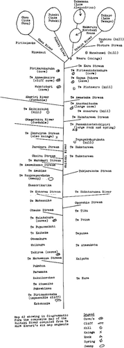
The tribal territory of Ngāi Tahu is extensive, providing a variety of foods, medicines and other materials essential for physical and spiritual sustenance (Evison Citation1993; Anderson Citation1998). Ngāi Tahu travelled extensively throughout a range of landscapes. Like other indigenous peoples, they developed their own mapping skills and systems of knowledge. Early examples of Māori cartography, including the map of the Waitaki drawn by Te Warekorari (found in Barton 1998 and presented in ), in addition to portraying patterns of movement throughout the Waitaki, confirm the ability of Māori to think systematically and graphically about space. Within the Alexander Turnbull Library map collection there is a hand drawn map that was prepared by Te Warekorari. However, Barton (Citation1998) has redrawn this map—along with many other maps across New Zealand.
Other types of map accessed were those prepared by the early explorers [such as Shortland (Citation1974) and MantellFootnote7] and surveyors of Canterbury and Otago [for example Thompson and von Haast (Citation1948)]. A map: ‘When interpreted correctly, complements the study of historical change because it provides visual cues and supporting evidence to other sources of historic and contemporary information’ (Egan & Howell Citation2005, 134).
Journals recording the personal observations of explorers, surveyors and early settlers provide another level of specificity regarding the natural and physical environment of the Waitaki with which Ngāi Tahu interacted. For example, Selwyn (Citation1844) provides a description of the braided Waitaki River:
The river or rather the valley through which it rushed appeared to be nearly a mile broad. It was furiously rapid … When not flooded it runs on many streams each of which is in itself a small river, over stones and pebbles and between islands and banks of shingles. In the winter months it has comparatively little water, the mainstream being then not deeper than a man's waste in the shallowest places, but still dangerous to ford by reason of the violence of the current.
Descriptions such as this are significant in understanding patterns of river flow and help illustrate the historical hydrograph.Footnote8 Whānau equipped with this information sought to mimic the seasonal variability of flow in contemporary forums, most notably resource consent hearings.
Shortland (Citation1974) describes the terrestrial environment of North Otago:
Between Oamaru and Papakaio vegetation consisted mainly of cabbage trees and flaxes, again so dense as to make it essential to seek a pathway along the foreshore rather than attempt to find a passage through the plant life. This abundance of trees and shrubs created an ideal habitat for birdlife. Pigeons, pukeko, quail, grey dark and blue mountain ducks were much in evidence between Oamaru and Omarama.
… the huge swamp at the head of Lake Tekapo of which the delta of the river consists of thousands of waterfowl amongst which the spotless plumage of the white crane was very conspicuous.
To make the descriptions of the natural environment more visible to Ngāi Tahu whānui, (and also confirm observations) historical photographs and paintings of the Waitaki prepared by early explorers and settlers, including for example the paintings of John Gully that complemented the writings of von Haast, represent a valuable complementary resource as shown as Box 1 Instead of simply reading descriptions of the Waitaki, it becomes possible to see the lands that Ngāi Tahu traversed historically.
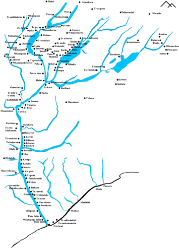
The many place names of the Waitaki confirm widespread use of the catchment by Ngāi Tahu (). was developed from a map prepared by Ngāi Tahu kaumātua in 1879–1880. This original map was then copied by Beattie in the 1920s. The reproduction, which is publically available, is held by the Hocken Library. Traditionally place names were preserved by oral transmission in whanau and hapu contexts. Maps of important places including camping places, settlements, and the different resources that could be obtained, were all held in the memory of individual Ngāi Tahu like whakapapa, where the sequence and significance of every name had its own place (Krupnik Citation2002). In addition, the writings of ethnographers, such as Beattie, yield hundreds of place names (Beattie Citation1944, Citation1945). Sadly, over time the precise location of many has been lost. Krupnik (2002) argues that the accurate collection of place names is essential to the long-term preservation of ethnographic landscapes, which is seen as integral to cultural identity and cultural wellbeing.
Note: Adapted by K. Nelson from the Beattie 1920s' map and Beattie (Citation1945).
Russell (Citation2000a) and Jongman (Citation2000) contend that over time land use changes inevitably result in changes to the character of landscapes that have been built up over centuries, together with observable changes to ecosystem composition and structure. Consistent with this proposition, the changes observed and experienced in the Waitaki can be compiled from an assortment of data sources. Key events in the history of the Waitaki, in the form of a timeline, provide insights to the changes experienced by Ngāi Tahu since the nineteenth century post-European settlement (). Understanding the nature, extent and timing of change is important in resource management contexts, such as the preparation of impact assessment, especially cumulative effect assessments, or the development of adaptive management regimes where it is essential to identify and untangle cause and effect.
Table 3 Key dates for event and changes that occurred in the Waitaki catchment.
Land use change had a significant impact on the waterways of the Waitaki. Water was expropriated as settlers claimed springs for their livestock and diverted flows to supply farms and towns. Eventually fences to control livestock and European concepts of private ownership of land impacted Ngāi Tahu access to mahinga kai (food gathering) and constrained the mobility upon which a mahinga kai based economy had previously depended. While photographs enable some of the changes to the landscape to be visually represented, historical texts, especially the testimony of whānau at various hearings, enable readers to understand how Ngāi Tahu may have felt when experiencing these changes.Footnote9
The loss of land, changing environment, and the movement to urban areas, impacted other Māori values, beliefs and practices such as mana (prestige, authority, influence) and rangatiratanga (chieftainship, decision-making rights).
Rangatiratanga
In Māori society the right of control and the right to use a resource were inseparable and together constituted an effective management system. Before the coming of settlers Ngāi Tahu controlled a vast land (Anderson Citation1988). Control was exercised by ‘those holding mana whenua rights over the resource, these being established by whakapapa, take raupatu (conquest) and ahika (continuing usage)’ (Jull Citation1989, 10).
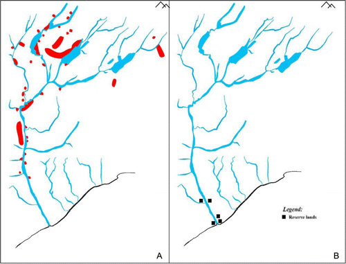
The lifestyle of Ngāi Tahu changed irrevocably with European settlement (Waitangi Tribunal Citation1991). According to the government's policy at that time, small tracts of land were identified as reserves to protect Ngāi Tahu from new immigrants. However, in practical terms these reserves enabled all lands beyond the boundaries of reserves ( and ) to be opened for settlement. Reserve creation was (arguably) therefore a means for government to limit the area of land controlled by Ngāi Tahu and avoid compensating Ngāi Tahu for alienated land and resources. In effect it was an effort to extinguish Aboriginal title, and the rights of Manawhenua stemming from title, through administrative and bureaucratic means. Analysis of historic maps aids understanding of the scale and impact of land loss on the pattern of settlement and the mahinga kai based culture and economy of Ngāi Tahu.
Maps prepared by Ngāi Tahu in 1879–1880, and copied by Beattie, illustrate the pattern of settlement in the Waitaki historically, and reflect Ngāi Tahu's preference for siting the larger and more permanent settlements on major waterways. Smaller, but regularly occupied, settlements were established along the tributary river systems. Descriptions of the different types of settlement are found in Beattie (Citation1945). shows the permanent and temporary settlements within the Waitaki pre-European settlement while 3B illustrates the location of the reserves allocated following European settlement. Given that each of the sites in represents a site from which resources were sourced, the sense of loss, specifically the extent to which access to the resource base was constrained, can be appreciated. Significantly, access was lost to the important weka grounds of the upper Waitaki (see ).
Note: Adapted by K. Nelson from the Beattie 1920s' map and Beattie (Citation1945).
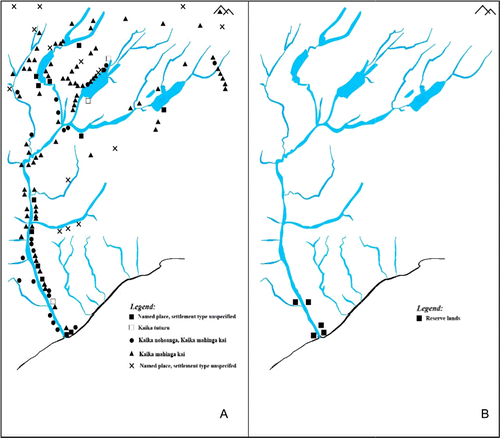
Because this paper is premised on using historic data to guide contemporary resource management, the loss of sites in the upper catchment led to negotiation of a number of nohoanga (camping sites) as part of the redress for the Ngāi Tahu Claim.
Settlements are particularly important as they provided a base from which mahinga kai activities could be undertaken. As the lands of the South Island were settled, Ngāi Tahu thought they had protected their mahinga kai in the sales agreements that were negotiated (MacKay Citation1872). Horomona Pohio was asked when giving evidence at a Native Land Court hearing in 1868:
‘Did Mantell say anything about your eels or weirs?’ to which he replied ‘Yes, Mantell said your eel pas will remain yours. … He told us we should have our pas, graveyards and eel weirs’.Footnote10
Our impression was that when the land is surveyed our reserves will be handed to us … It is not our wish to enlarge upon all the promises which were made to us by the land purchase commissioners such as—the government will apportion your land for your children, besides your abode's and your cultivations; your eel pas shall remain yours also; the large rivers shall remain yours also; your fishing ground on the coast shall remain yours also etc etc. Little of all this has been fulfilled to us by the government—much of it is wholly forgotten.Footnote11
There were two provisions in the deeds which the court operated upon. The first was the reservation of residences, burial grounds, and mahinga kai … Mahinga kai being held to include fisheries, your eel weirs and so on excluding merely hunting grounds and some things which were never made property in the sense of appropriation by labour. The court made orders for all these reserves. The other provision was a covenant that further land should be set out for them.Footnote12
All former sources of food supply were cut off … The tui and all other birds are gone and the roots of the kauru and the fern have been destroyed by fire … The reserves are too small to run stock on and cultivate as well. In 1848 there were plenty of fish and other food, but after the land got settled the people gradually were prevented from obtaining food that was available in former times.Footnote14
Aside from the loss of land, the transition from tino rangatiratanga (in effect being self governing) to a colonial government with prescribed land and resource laws, that took little or no cognisance of Ngāi Tahu's dependence on mahinga kai, directly impacted whānau, hapū and iwi. For example:
A matter that has inflicted serious injury on the natives of later years and for the most part ruined the value of the fishery easements granted by the Native Land Court, is the action of the Acclimatisation Societies in stocking many of the streams and lakes with imported fish. These fish are protected by special legislation. Consequently the natives are barred from using nets to catch whitebait in season, nor can they catch eels or other native fish in the streams for fear of transgressing the law.Footnote15
Mahinga kai: resource base
Ngāi Tahu contend that ‘mahinga kai’ is a generic term for places at which food and other resources were caught, collected or processed, and included eeling camps, rat runs, fishing reefs, seal and mutton bird colonies, shellfish beds, trees from which birds were snared, cultivations, and fern and tī patches (Anderson 1988, 1998). People generally worked together in whānau groups within a defined food gathering area (Anderson Citation1988).
According to Matiaha Tiramo¯rehu there were eight spatial defined areas of mahinga kai between Purehurehu and Kaiapoi. Those regions were Purehurehu, Waiputi, Waihemo, Waitaki, Makihikihi, Hakatere, Waikirikiri and Kaiapoi (Anderson Citation1998). This case study is concerned with only one of these regions: the Waitaki.
The 1879–1880 map and manuscript which was an initiative by kaumātua from neighbouring hapū to map their collective territory, their mahinga kai interests and values associated with particular sites enables reconstruction of the resource used across the Waitaki.Footnote16 These records allow a more complete examination of the system of food gathering within the Canterbury and Otago regions. For example, illustrates the food resources sourced from the Waitaki Valley. From the manuscript accompanying the map and Beattie (Citation1945) we know that at least 30 different foods and materials were gathered from more than 130 sites throughout the Waitaki. For each site drawn on the map, the manuscript and Beattie (Citation1945) provide a narrative about the site including the valued species found at the site. shows eight of the most commonly gathered species. This type of map, which is akin to use maps found in traditional use studies, is consistent with Poole's (2003) description of cultural mapping, which he contends goes beyond strict cartography to include cultural resources other than land, including ‘anthropological, sociological, archaeological, genealogical, linguistic, topographical, musicological and botanical’ resources (section 2.5). Poole (Citation2003) explains that mapping to many indigenous communities, is perceived as an instrument for recovering control of lost territory, or negotiating access rights with outside interests.
Note: Derived from the 1879–1880 map and manuscript, and Beattie Citation1945; Map prepared by K. Nelson.
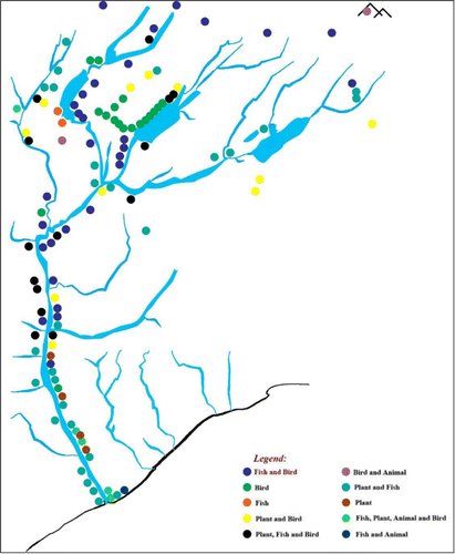
Table 5 Percentage of sites that species were gathered from in the Waitaki catchment (see also .
Using the maps and manuscript prepared by kaumātua in 1879–1880, a number of analyses are available using site and species data which, when considered alongside quotes from historic references, yield valuable and rich descriptions for whānau today. For example, is an example of a species distribution map, which specifically illustrates the distribution of sites supplying eels and weka respectively throughout the Waitaki catchment. It also provides a context from which the impact of change on the culture of Ngāi Tahu can be assessed. More importantly, the analyses can contribute to more purposeful and appropriate decision-making. For example, are the habitats of these sites today conducive to reintroducing the species for which they were renowned?
Note: Adapted by K. Nelson from the Beattie 1920s' map and Beattie (Citation1945).
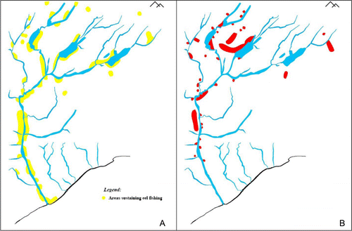
confirms that approximately 69% of sites in the catchment supplied eels—a significant resource for whānau. With respect to eels, however, at the various Royal Commissions of the late nineteenth century, Ngāi Tahu whānau complained about the loss of land and its effects on whānau:
They [Ngai Tahu] complained that, although they have a closed season for eels, the Europeans catch them all the year round. In olden times the natives had control of these matters, but the advent of the Europeans and the settlement of the country changed the state of affairs and destroyed the protection that formerly existed, consequently their mahinga kai (food producing places) are rendered more worthless every year.Footnote17
In the olden times the people were able to procure kauru … it was bartered for other kinds of food … another kind of food they are now deprived off is edible berries and also fern root.Footnote18
Some of us were nearly put in jail for catching wekas on some of the runs … [They] put a notice in a newspaper that natives would not be allowed to catch wekas on the runs, wanted to preserve wekas for game, and to kill the rabbits; but afterwards the wekas were killed on these runs by dogs and poison. Having seen the wekas lying dead on the runs in numbers, but the station owners would not allow the natives to kill or catch them; they threatened to shoot us if we went on their land … we are left without the means of obtaining the food we used formerly to depend on.Footnote19
Note: Adapted by K. Nelson from the Beattie 1920s' map and Beattie (Citation1945).
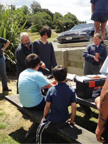
With promises of government payments for the purchase of lands, the retention of fishing and hunting rights, and allocation of a series of reserves, Ngāi Tahu were persuaded to surrender title to significant tracts of land. As an unanticipated consequence of the sale and transition to newly acquired reserves, Ngāi Tahu were no longer free to migrate seasonally throughout the Waitaki and other parts of the country. As the lands along the Waitaki catchment were taken over by settlers, fences curtailed gathering resources from valued sites. Yet, Ngāi Tahu are determined to maintain their relationship with mahinga kai, and inculcate their historical relationships with ongoing efforts to restore mahinga kai to the landmark position it once held within whānau and hapū. Enhancing the capacity of Ngāi Tahu whānui (in respect of practical management skills, together with knowledge of mahinga kai) is a prerequisite to such restoration. Wānanga (training workshops, learning forums) are an integral tool for sharing knowledge within and between whānau. is an example rangatahi (youth) learning at a marae based eel wānanga.Footnote21
The information resource specific to the Waitaki that, in part, is presented here is intended to aid this capacity building (Tipa, forthcoming).
The socioeconomic context
Historically, engagement in mahinga kai practices created opportunities for experiential learning, and shared lived experiences in which knowledge of ecosystems and species was shared, thus ensuring whānau and hapū were sustained culturally, physically and spiritually. Gathering was a social activity as well as an economic one. The extensive network of rivers, lakes and mountain ridges in the Waitaki also provided avenues of travel essential to Ngāi Tahu social and economic relations, providing links to the inland areas of the Mackenzie Valley, to the Upper Clutha and to Te Tai Poutini (Brailsford Citation1996). Hapū and inter-hapū ties and alliances, the backbone of Ngāi Tahu social and economic exchange systems, depended upon the free and easy movement of people within and beyond the Waitaki. However, by the mid 1800s change was on its way. As early as 1848 Ngāi Tahu were voicing their concerns in correspondence to the Crown and in statements of evidence presented at the Royal Commissions convened to hear the concerns of Ngāi Tahu with respect to the impact of European settlement on mahinga kai and their associated socioeconomic context. For example:
All that is left now are the big rivers where they run right up into the mountains, and all our mahinga kai in regards to eels, inaka and other fishes are all dried up. Stone buildings and houses are standing on what were mahinga kai (Tiramorehu undated).Footnote22
The wages earned at shearing and harvesting soon goes to pay off debts. Many of us are in debt, even those who have land.Footnote23
The rivers are closed to us and reserves are insufficient to support us. The young men may be able to work at shearing and harvesting but for a large part of the year there is no work to do.Footnote24
We are unable to catch flounders, inanga, or eels without risking the chance of being fined or imprisoned.Footnote25
Today, many whānau no longer live in close proximity to a river, mahinga kai is not their livelihood, and mahinga kai species may no longer be their staple diet. However, despite these changes, it is important to emphasise that many traditional mahinga kai behaviours have survived, while others are being re-established.
Ngāi Tahu has never alienated their rights to mahinga kai, yet initiatives by Manawhenua to re-establish mahinga kai as an economic base in contemporary settings continues to be fraught with issues and barriers. New Zealand's resource laws, specifically the Treaty of Waitangi (Fisheries Settlement) 1992 and Māori Fisheries Act 2004 seek to define customary interests as non-commercial. The fisheries legislation makes a clear distinction between three types of fishery: commercial; recreational; and customary. Regulations refer to non-commercial customary interests and prescribe penalties for deriving economic benefit from customary catch. It is necessary to understand how this impacted Māori. In one decision Justice Paterson found that:
[T]he basic unit of traditional Māori social structure was not the iwi (tribe) at all, but the hapu (sub-tribe, clan) … [R]esource management and welfare functions were typically carried out at whanau or hapu level and not iwi level. Often an iwi had no rigid structure and hapu entered and left collectives as needs dictated … Fishing rights were held by hapu, not iwi, and, accordingly, ‘it is, in the main, rights which were vested in hapu which were infringed by the QMS and which the Crown has now abrogated and taken away’.Footnote26
Returning to the quote from Justice Paterson, the question to be asked is how hapū benefit from the changes in fisheries legislation that have occurred over the last 20 years. The expectation could be that the benefits of Māori participating in commercial and customary fisheries management would accrue to hapū. But this cannot be assumed as the beneficiary of the management system are not necessarily prescribed in law which leaves it to be negotiated internally within the iwi—in other words it is the business of the iwi to sort. Further, it cannot be assumed that the benefits will only accrue to hapū as the Māori Fisheries Act 2004 explicitly states
that all members of the iwi are to benefit regardless of where they reside; and
the assets that are being managed by iwi entities can benefit Māori in general and communities.
More recently the term ‘tangata whenua non-consumptive uses’ was included in the Draft National Freshwater Policy Statement, which suggested that constraining customary interests to non-commercial interests could emerge in freshwater management discussions.Footnote27 Ngāi Tahu continue to challenge this artificial distinction and contend they did not sell or give up their rights to their mahinga kai or the right to occupy and use their reserves (MH Pera, pers. comm. 2009; Tipa Citation2012, Citation2013).
But the implications of government regulation have had a secondary, more insidious, impact. With respect to mahinga kai and, more specifically, the activity of fishing, fisheries regulation now tries to dictate what whānau fish, how they fish, and when they fish. But this knowledge (i.e. the what, how and when of fishing) is the basis of mātauranga Māori, the knowledge that Ngāi Tahu are supposed to possess and apply. In other words, the changing face of mahinga kai as a result of government regulation also resulted in fishing practices, decision-making and knowledge-generating processes associated with mahinga kai being changed or alienated from Ngāi Tahu whānui. If mahinga kai is to indeed remain an integral part of Ngāi Tahu cultural identity, the need to source a variety of data sources to complement the knowledge still held within whānau and hapū, and to rebuild and reinstate practices, is therefore further reinforced.
Using historical data to inform contemporary environmental management
This paper illustrates how an analysis of historic data sources affords opportunities to reconstruct the past and provide descriptions and graphic depictions of the history and life ways of, in this case, Ngāi Tahu; the changes they have experienced over time, and the consequent impact on whānau and hapū. Such reconstructions represent a valuable resource for Ngāi Tahu whanui, the wider public and, more specifically, resource managers; and help explain why and how particular landscapes and resources remain of particular cultural and economic significance.
The Waitaki case illustrates how historic resources (e.g. survey maps, surveyors' journals, whānau maps and manuscripts, and evidence to Royal Commissions) represent extremely valuable resources that complement the mātauranga Māori held within whānau and hapū today. Formulating a depiction of traditional life from all available data sources provides a context within which Ngāi Tahu are able to assess contemporary associations and implement purposeful, appropriate, effective and practical initiatives to rehabilitate, restore, create, and or protect landscapes and resources. summarises initiatives underway to restore the mahinga kai base in North Otago and the Waitaki.
Table 6 Sites from which species were historically gathered from the Waitaki and North Otago compared to current status.
Ngāi Tahu are cognizant of the fact that the escalating demands for freshwater have the potential to further erode their mahinga kai based culture and economy, a detrimental process that had its beginning more than a century ago. This awareness underpins contemporary efforts to protect and restore remaining mahinga kai landscapes. It also drives the endeavours of Manawhenua to determine what activities their customary rights entitle them to participate in with respect to mahinga kai and freshwater management, as evidenced most recently by negotiations between iwi, the Iwi Leaders Group and the Crown with respect to freshwater.Footnote28
Catchment specific information resources can also be used to inform the development of responsive environmental monitoring programmes. The resources and programmes developed for Ngāi Tahu whānui represent an approach that brings ‘the past into their own future’ (Larsen Citation2006, 320). Resource managers are required, pursuant to section 35 of the Resource Management Act 1991, to prepare state of the environment reports. An increased understanding of historic patterns of Ngāi Tahu settlement and resource distribution and use, in effect provides a baseline (and the context) from which changes experienced by Ngāi Tahu whānui can be evaluated. Using the information derived from the maps (presented in ) Ngāi Tahu have established a monitoring network of 30 sites on streams throughout the catchment and 14 wetlands in the lower catchment. Across New Zealand there are other examples of tangata whenua (people of the land) engaged in monitoring the state of their tribal territories.
Conclusion
While it is possible to find histories of significant people or the social institutions important to the development of a region, of equal value (but fewer in number) are histories of environmental conditions and environmental change over time. Yet maps, photographs and survey records are available and their individual value is recognised. However, many remain unassembled and unavailable to those who utilise and manage a landscape, including resource managers. In the case study presented here we have demonstrated that diverse historic data sources can be integrated into a meaningful resource. By developing an informative and highly visual resource for Ngāi Tahu whānui and the wider community, we have made it possible to explore a historical landscape in an open and non-confrontational context for information sharing, thus utilising publicly available data and private sources of knowledge (such as whānau, hapū and iwi archives). This resource can hopefully serve as ‘common ground’ for catchment-level thinking and management. Examples of how Ngāi Tahu have developed restoration strategies in response to the historical data have also been introduced.
Ngāi Tahu contend that a conscious effort is needed to reverse the history of degradation of landscapes and the alienation of Ngāi Tahu from an active and effective role in freshwater management. But many Ngāi Tahu realise that a new ethos for water management is needed. In the midst of this search for new and creative ways of doing it better, Ngāi Tahu will continue to seek to protect their rights ensuing from their connection to lands and waters found within their tribal territories, including the catchment of paramount importance–the Waitaki.
Internet resources
www.ngaitahu.iwi.nz
http://spinitwide.com/view/iwi-leaders-groupcommitted-to-fresh-water-discussions
http://www.iwichairs.maori.nz/Kaupapa/Fresh-Water/Freshwater-Report.pdf.
Appendices of the Journal of the House of
Representatives
AJHR, 1876 G7
AJHR, 1881 G7
AJHR, 1888 G1
AJHR, 1888 G8, p. 16
AJHR 1891 G-7
AJHR 1904 D1A
New Zealand Gazette
NZ Gazette 1868 pp. 263–265
New Zealand Court Cases
Te Waka Hi o Te Arawa and others v Treaty of Waitangi Fisheries Commission (4 August 1998) unreported, High Court, Auckland Registry, CP 395/93 (Wgtn) Anderson J).
Pers. comm.
M. H. Pera
Photos sourced from:
Alexander Turnbull library
David Wall Photographer
Kyle Nelson
Notes
1. The indigenous people of the lower South Island of New Zealand as defined in the Te Rūnanga o Ngāi Tahu Act 1996, Ngāi Tahu Claims Settlement Act 1998, and see www.ngaitahu.iwi.nz/.
2. The Ngāi Tahu claim against the Crown that was lodged in 1849 was settled in 1998 with the many agreements between the Crown and Ngāi Tahu being enacted in the Ngāi Tahu Claims Settlement Act 1998.
3. Those people who exercise customary authority or rangatiratanga over the whenua (land) in an identified area.
4. The information resource that has been prepared is called ‘Ko Waitaki te awa: the power of a silenced river’.
5. The extract ‘Te Mauri o Te Waipounamu—the South Island comes into being’, written by Peter Garven for the Southern Māori in the Lakes District Exhibition tells us of the travels of Aoraki and his brothers. ‘There was no New Zealand. The great sea of Kiwa rolled over the place that is now Te Waipounamu. Before Rakietunei (sky father) wedded Papatuanuku (earth mother) each had children from previous unions. After the marriage some of Raki's children came down to inspect the new wife of their father. They were Aoraki, Rakiroa, Rakirua and Rarakiroa and they arrived from the heavens in the canoe called Te Waka-a-Aoraki. They proceeded to inspect Papatuanuku who lay as one body in a huge continent known as Hawaiki. When the explorers attempted to return to the celestial realms the karakia (invocation) which should have lifted the canoe back to the heavens failed and the canoe sank onto an undersea ridge, turning to stone and earth in the process. The voyagers climbed onto the high side of Te Waka-a-Aoraki and were turned to stone. Aoraki became Mount Cook and his three younger brothers are the three highest peaks near him. As the great canoe settled on its side it became the whole of the South Island whose oldest name is Te Waka-a-Aoraki’.
6. This quote is taken from the To¯puni Brochure for Aoraki. This publication by the Department of Conservation (DOC) is available from information centres and DOC offices.
7. The diaries of Mantell are found in the Alexander Turnbull Library.
8. A hydrograph is a graph showing the rate of flow (discharge) over time past a specific part of a river, or other channel or conduit carrying flow.
9. The material submitted in support of claims to the Waitangi Tribunal represents a valuable resource, as does evidence submitted to resource management hearings.
10. Recorded in AJHR (1876) G7, p. 9.
11. A Report on the Petition on Ngai Tahu by FD Fenton Esquire Chief Judge Native Lands Court can be found in AJHR (1876) G7.
12. See correspondence, Mr Fenton to the Hon the Native Minister Native Lands Court Office, Auckland July 10, 1876, is found in AJHR (1876) G7.
13. See AJHR (1876) G7, p. 2.
14. AJHR (1891) G7, p. 47.
15. AJHR (1888) G8, p. 16.
16. Nearly 1400 places across Canterbury and Otago were written down and mapped (see Taiaroa Citation1880) which coincided with the Smith Nairn Commission enquiry (1881).
17. AJHR (1891) G7, p. 47.
18. AJHR (1891) G7, p. 57.
19. AJHR (1891) G7, p. 48.
20. Recognised as a taonga by the Crown in Schedule 97 of the Ngāi Tahu Claims Settlement Act 1998.
21. National Institute of Water and Atmospheric Research scientists were present at this wānanga so there was a sharing of mātauranga Māori and fisheries data.
22. Matiaha Tiramo¯rehu also voiced his concerns Smith Nairn Commission, MA 67/7.
23. AJHR (1891) G7, p. 48.
24. AJHR (1891) G7, p. 48.
25. AJHR (1891) G7, p. 48.
26. Te Waka Hi o Te Arawa and others v Treaty of Waitangi Fisheries Commission (4 August 1998) unreported, High Court, Auckland Registry, CP 395/93 (Wgtn) Anderson J).
27. The Draft National Freshwater Policy Statement can be found at www.mfe.govt.nz/.
References
- AndersonA 1988. Wakawaka and mahinga kai: models of traditional land management in southern New Zealand. In: Davidson J, Irwin G, Leach F, Pawley A, Brown D eds. Oceanic culture history: essays in honour of Roger Green. New Zealand Journal of Archaeology Special Publication 1996. Pp. 631–640.
- Anderson A 1998. The welcome of strangers. Dunedin, University of Otago Press.
- Barlow C 1991. Tikanga Whakaaro: key concepts in Māori culture. Revised 1996. Auckland, Oxford University Press. 111 p.
- Barton P 1998. Māori cartography and the European encounter. In: Woodward D, Malcolm Lewis G eds. Cartography in the traditional African, American, Arctic, Australian and Pacific societies. Chicago, University of Chicago Press, 1998. p. 505. Material can also be found in MS Papers 5386-2 Sourced from Alexander Turnbull Library.
- Beattie H 1944. Māori placenames of Otago. Christchurch, Cadsonbury publications.
- Beattie H 1945. Māori placenames of Canterbury. Christchurch, Cadsonbury publications.
- Boast RP 1999. Māori fisheries 1986–1998: a reflection. Victoria University of Wellington Law Review30/1:111–134.
- Brailsford B 1996. Greenstone trails: the Māori and Pounamu. Wellington, Stoneprint Press.
- Collier J Jr, Collier M 1986. Visual anthropology: photography as a research method. Albuquerque, University of New Mexico Press.
- Durie M 1995. Ngā Matatini Māori: diverse Māori realities. Paper presented at the Wānanga Pūrongo Ko¯rerorero: Māori Health Framework Seminar. Marae, Ngaruawahia, Turangawaewae.
- Edwards E, Hart J eds. 2004. Photographs objects histories: on the materiality of images. New York, Routledge.
- Egan D, Howell E 2005. The historical ecology handbook – A restorationists guide to reference ecosystems. , United States, Society for Ecological Restoration Institute, Island Press.
- Evison, HC 1993. Te Wai Pounamu: the Greenstone Island. A history of the Southern Māori during the European Colonisation of New Zealand. Wellington, Aoraki Press.
- Jongman RHG 2000. The difficult relationship between biodiversity and landscape diversity. In: Brandt J, Tress B, Tress G eds. Multifunctional landscapes: interdisciplinary approaches to landscape research and management. Conference material for the international conference on “Multifunctional landscapes: interdisciplinary approaches to landscape research and management”. Centre for Landscape Research, University of Roskilde, Denmark. Pp. 72–81.
- Jull J 1989. Traditional Māori methods for natural resource management in a contemporary world, Masters thesis. Lincoln, New Zealand, Lincoln University.
- Kai Tahu Ki Otago Ltd 2005. Kai Tahu Ki Otago natural resource management plan. Dunedin, Author.
- Krupnik I 2002. Northern ethnographic landscapes: perspectives from circumpolar nations. Compiler and Editor with Rachel Mason. International publication project sponsored by the U.S. Park Service, Alaska Office.
- Larsen SC 2006. The future's past: politics of time and territory among Dakelh First Nations in British Columbia. Geografiska Annaler88B: 311–321.
- Lincoln EnvironmentalAugust 2002. Waitaki strategic water study. Prepared for Ministry of Agriculture & Forestry, Environment Waitaki, Ministry for the Environment.
- Mackay A 1872A compendium of official documents relative to native affairs in the South Island, Memorandum on the origination and management of native reserves in the Southern Island Two Volumes.
- Ngāi Tahu Publications 1997. Crown settlement offer. Te Karaka special edition. Christchurch, Te Rūnanga o Ngāi Tahu.
- Poole P 2003, March. Cultural mapping and indigenous peoples. A report for UNESCO. http://www.landcoalition.org/sites/default/files/publication/704/03_UNESCO_cultural_mapping.pdf (accessed 18 August 2009).
- Russell EWB 2000a. Historical aspects multifunctionality in landscapes. In: Brandt J, Tress B, Tress G eds. Multifunctional landscapes: interdisciplinary approaches to landscape research and management. Conference material for the international conference on “Multifunctional landscapes: interdisciplinary approaches to landscape research and management”. Centre for Landscape Research, University of Roskilde, Denmark. Pp. 122–132.
- Russell K 2000b. Landscape: Perceptions of Kai Tahu, Unpublished PhD thesis. Dunedin, University of Otago.
- Schneider TD 2003. An object lesson: photographic representation and the role of archaeology among the federated Indians of Graton Rancheria, Marin and Sonoma Counties, California. Masters thesis, University of Texas, Austin.
- Selwyn GA 1844. Journal 1843–1844, Typescript. Hocken.
- Shortland E 1974. The southern districts of New Zealand (Reprint). Christchurch, Capper Press.
- Taiaroa HK 1880. Mahika kai map to accompany Kai Tahu 1880.
- Tau TM, Goodall A, Palmer D, Tau R 1992. Te Whakatau Kaupapa. Ngai Tahu Resource Management Strategy for the Canterbury Region. Wellington, New Zealand, Aoraki Press.
- Te Rūnanga o Ngāi Tahu 1999. Freshwater policy statement. Christchurch, Author.
- Tipa G, Crengle H, Davis K, Allingham B, Symon A 2002. Cultural impact assessment: Project Aqua (Client report). Christchurch, Meridian Energy Ltd.
- Tipa G, Nelson K 2012Cultural flow preferences for the orari catchment (Client report). Christchurch, Environment Canterbury.
- Tipa G, Nelson K 2013. Cultural flow preferences for the Waihao – Wainono Catchment (Client report). Christchurch, Environment Canterbury.
- Von Haast, Sir JE 1865. Report on the headwaters of the river Waitaki. Sourced from Alexander Turnbull Library. 18 p.
- Von Haast HF 1948. The life and times of Julius von Haast. New Plymouth, New Zealand, Avery Press Ltd.
- Vuorela V 2000. Detecting and classifying change transitions in the landscape using combined spatial data sets. In Brandt J, Tress B, Tress G eds. Multifunctional landscapes: interdisciplinary approaches to landscape research and management. Conference material for the international conference on “Multifunctional landscapes: interdisciplinary approaches to landscape research and management”. Centre for Landscape Research, University of Roskilde, Denmark. Pp. 212–213.
- Waitangi Tribunal 1991. Ngai Tahu report. Wellington, Brooker & Friend.
- Walker R 1998 Review of Māori in the University. Auckland, New Zealand, University of Auckland.