ABSTRACT
The salience of mangroves as carbon sinks are being increasingly recognized in terms of “blue carbon.” Their significance at provincial level is critical in the era of decentralization after the reformation period. This study applied a content analysis to 27 Provincial Spatial Plans in Indonesia. The results were categorized into nine clusters. The findings indicated that the cluster prohibited activity was the most frequently mentioned in the context of management and utilization across provinces. This was followed by mangrove’s potential to be utilized as tourism and educational sites, while the aspect of “blue carbon” was largely overlooked. The results indicated the usefulness of Provincial Spatial Plans as a benchmark for the priorities and awareness of lower-level governments concerning mangroves.
Introduction
Mangrove offers multiple ecological functions and contributes positively to environmental matters as well as to society. Examples are disaster prevention (Osti et al. Citation2009), fish nurseries (Ilman et al. Citation2016), and as the more recently coined phrase “blue carbon” (as opposed to the “green” carbon contribution of terrestrial forests), which contributes toward climate change mitigation (Taillardat et al. Citation2018). Such multifunctionality is undoubtedly beneficial to society and the environment. However, it can lead to complex interpretations and multiple administrative layers within society with potential conflicts, as we discuss later in this study. Despite the importance of mangroves to the environment and human, the status and trends of mangrove distribution is decreasing (Giri et al. Citation2011). Mangrove deforestation remains a significant issue across Southeast Asia, with a total of 114,424 hectares (ha) being deforested – of which 60,906 ha of the total is accounted in Indonesia – between 2000 and 2012 (Richards and Friess Citation2016). Mangrove’s condition in Indonesia is worsening rapidly due to slack licensing regulations for entrepreneurs in municipalities and provinces (Sunyowati et al. Citation2016) or due to convoluted regulations which might create conflict – and therefore mismanagement of mangrove – between different departments (Irawan and Sari Citation2008). To address these challenges, spatial plans at a provincial level – that plays a central role as an environmental policy regulation instrument – need to be addressed and revised to realize sustainable mangrove ecosystem management.
This study focuses on a provincial level during the current decentralization phenomenon in Indonesia (Haryanto Citation2016). Furthermore, certain provinces in Kalimantan and Sulawesi exploit the mangrove ecosystem through aquaculture sector region developments (Richards and Friess Citation2016). Existing literature states that sustainable development can be achieved by integrating environmental aspects in the development and spatial planning of mangrove (Lantitsou Citation2017) or conversely, suitable spatial and environmental plans will support sustainable regional development (Maksin-Mićić et al. Citation2009). Therefore, this study investigated the current situation on a provincial level, analyzing 27 Provincial Spatial Plans (hereafter PSP), in contemporary Indonesia. We examined statements related to mangrove by applying a content analysis with coding keywords. Based on the results, we provided insights and suggest policy implementations for improvement.
Review of regulation hierarchy and policy
As a single country, Indonesia has the largest coverage of mangrove in the world (Giri et al. Citation2011). Accordingly, Indonesia has been developing their regulation hierarchy system, the latest system being based on Law No. 12 of 2011 concerning the Guidance on the Hierarchy of Legislation (Pembentukan Peraturan Perundang-undangan). Based on these new systems, the layers and the hierarchy of regulations can be streamlined into seven different layers, with higher levels having stronger legal force (Aditya and Winata Citation2018) ().
Figure 1. Mangrove’s Implementation Regulation (Law No. 26 and No. 27) shown within Indonesia’s Regulation Hierarchy.
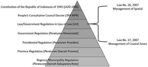
The implementation-level policy concerning mangroves range across two regulations; Law No. 26 of 2007 on Spatial Management (Penataan Ruang) and Law No. 27 of 2007 on the Management of Coastal Areas and Small Islands (Pengelolaan Wilayah Pesisir dan Pulau-Pulau Kecil) (Sunyowati et al. Citation2016). The former (Law No. 26/2007) generates and regulates the PSP documents, while the latter (Law No. 27/2007) generates document RZWP3K (Zonation Plan of Coastal Areas and Small Islands). The term mangrove is defined in Law No. 27/2007 that categorizes the ecosystem as a transition area between land and ocean ecosystems. The definition and the nature of mangrove – and therefore the authority under which it falls – are unclear. This is because land ecosystems and its management responsibilities falls under the Ministry of Environment and Forestry, while ocean ecosystem is the responsibility of the Ministry of Maritime Affairs and Fisheries. These issues have also been addressed in existing studies. These studies state that mangrove conservation needs to be managed through cooperation between the two ministries and local government and requires avoiding overlapping or contradictory policies (Heriyanto and Subiandono Citation2016). There are also other policies concerning the governing of mangrove ecosystems directly and indirectly, which have frequently led to adverse effects like confusion, different interpretations, and potential conflicts amongst government departments (Sunyowati et al. Citation2016).
The current decentralization phenomenon in Indonesia has also influenced the management hierarchy from a central to a lower level. Furthermore, decentralization has increased the number of provinces – from 27 in 1980 to 34 in 2013 – with provincial governments being responsible for supervisory functions and ensuring that the decentralization is effective (Nasution Citation2016). The enactment of Law No. 23 of 2014 on Local Governance (Pemerintahan Daerah) is another factor which focuses on transferring governance to provincial-level for transboundary resources, offering benefits involving various district areas, for example in the energy and mining sector (Budiyono and Firmansyah Citation2015).
Materials and methodology
There are currently 34 provinces in Indonesia with the authority to self-regulate their spatial plan based on Law No. 26 of 2007. Of these 34 provinces, we analyzed 27 PSP. Only 27 plans were analyzed due to limited data availability (i.e. publicly accessible documents from the database of the Indonesian Ministry of National Development Planning) (Direktorat Tata Ruang dan Pertanahan – Bappenas Citation2013; JDIH Biro Hukum Kementerian Dalam Negeri Citation2013; Bappeda Provinsi Sumatera Selatan Citation2017; JDIH BPK RI Database Peraturan Citation2017).
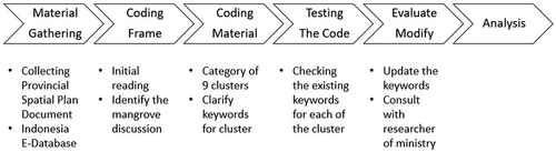
This study utilized a content analysis method to observe the different provinces’ PSP related to mangrove. A systematic content analysis involves a sequence of steps such as building a coding frame to cover several main categories and then dividing the data into coding units (Schreier Citation2012). In applying this content analysis method based on coding keywords concerning mangrove management were identified by the researchers as code. The selection of terms was based on their frequency and their relevance to mangrove management. Next, it was tested and modified to better reflect the statements. A comprehensive list of keywords and a visualization of the selection process are outlined in the Appendix. If a certain keyword from the clusters is included in the statements, it means that the province’s spatial plan contained those specific cluster elements. For example, the term “obyek wisata” was used as a keyword for the cluster “tourism.” Furthermore, an interview was also held with the Regional Development of the Planning Agency West Java the and Balikpapan Fishery Agency to explore the current situation of spatial planning. Based on these processes and criteria, the policy trends and status of the mangroves in the PSP were determined.
Results
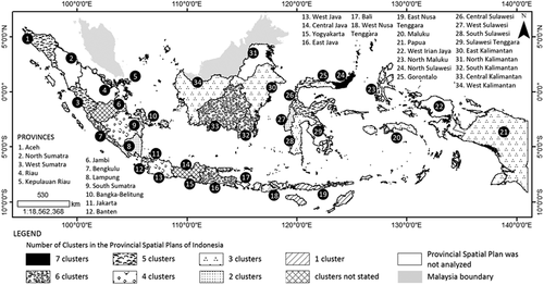
The content analysis of the PSP resulted into nine clusters: these are (1) aquaculture, (2) carbon storage, (3) disaster prevention, (4) fish nursery, (5) prohibited activity, (6) reforestation, (7) regulating services, (8) research and education, and (9) tourism. presents the distribution of nine clusters in the provinces of Indonesia while shows the enforcement year of PSP and frequency of the clusters. shows the location of each cluster across Indonesia while reflects the location map and number of clusters in each province. The results showed Prohibited activity to be the most frequently stated cluster with 21 provinces explaining what kind of activities these are. These include logging, polluting, and damaging the mangrove trees, as well as decreasing or converting the mangrove ecosystem into another function. The second and third most frequent clusters stated in the PSP are tourism and research and education, respectively. These activities are allowed as stated in the spatial plan as long as they follow and respect the conservation principle. Mangrove conservation efforts particularly reforestation, is included in the spatial plan with 12 provinces (fourth most frequent) mentioning it. Other ecosystem services such as fish nursery, disaster prevention, and other regulating services are among the clusters that were mentioned in the spatial plans of 10, 8, and 5 provinces, respectively. The cluster of aquaculture is discussed in the spatial plans of seven provinces. For the least-stated cluster, mangrove forests as a carbon storage are discussed in three provinces; Central Kalimantan, Jakarta, and Papua.
Table 1. Frequency of nine clusters: (a) prohibited activity, (b) tourism, (c) research and education, (d) reforestation, (e) fish nursery, (f) disaster prevention, (g) aquaculture, (h) regulating services, and (i) carbon storage, and enforcement year across the provinces of Indonesia
Figure 2. Frequency of the clusters across the provinces in Indonesia. Note: The total number of provinces with spatial plans is 27.
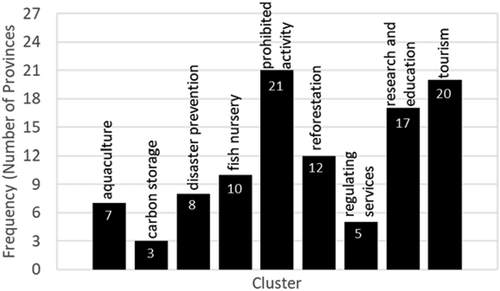
Figure 3. Location map of the provinces showing the nine clusters: (a) prohibited activity, (b) tourism, (c) research and education, (d) reforestation, (e) fish nursery, (f) disaster prevention, (g) aquaculture, (h) regulating services, and (i) carbon storage. Provinces with black shade state the cluster, while unshaded provinces did not state the cluster. Areas that are filled with crisscross patterns are the provinces that were not analyzed due to unavailability of the spatial plans, while the gray sections indicate Malaysia boundaries.
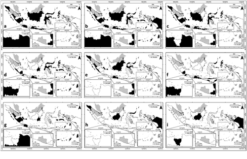
Figure 4. Location map of the nine clusters across the provinces in Indonesia.
Discussion
The contents of the PSP that were focused on mangrove ecosystems can be influenced by the provinces’ characteristics, as according to PSP Formulation Guideline issued on Public Works Ministry Regulation, the formulation of spatial plans are based on province’s spatial characteristics and resource capacity. In this section, differences in the PSP will be discussed in the context of socio-political, cultural and ecological backgrounds.
The spatial plans in each province can be affected by the other laws like the Presidential Regulation for Island Spatial Plan, which the policy states different objectives for each island. In the Kalimantan island, the first objective stated inside the Island Spatial Plan is to focus on conservation and preservation in forestry as according to Presidential Regulation No. 3/2012, while in Sulawesi island, their first objective is to establish a central marine economy as according to Presidential Regulation No. 88/2011. Another case of the provinces that differ in objectives is a combination of Papua and Sulawesi. The spatial plan of Papua states that 70% of the island’s biodiversity including marine should be conserve as according to Presidential Regulation No. 57/2014, while Sulawesi only conserve 40% of their natural resources. These differences in socio-political aspects are reflected in the results of the content analysis, for example in carbon storage cluster with two provinces in Kalimantan and Papua, while none in Sulawesi Island.
That correlation shows connection of the Island Spatial Plan with statement of the PSP, with the previous have roles as coordination tool of development program, but unable to be used as a basis to give permission for spatial plan utilization. Looking from the regulation system itself, the Presidential Regulation is in lower level of Law.
As regards the backgrounds of the differences of the provinces, it is necessary to consider that social condition, which drives the province economy, can influence the statement in PSP. Socio-economic development influences the nature-society interactions, for example, the ecological-cultural value systems are attributed to mangrove ecosystems, and the rate of mangrove exploitations (Armitage Citation2002). Through difference of culture, developed from long historical values, the province will also develop certain perspective regarding the utilization of specific ecosystem. Kalimantan Island, for example, with extensive forest ecosystem, the provinces are more likely include the prohibited activities statement. In addition of Indonesia environmental characteristics which develop its area based on local resources (Aritenang Citation2008), culture plays the role in transformation of the main industries, such as the transformation from agriculture to tourism (Pudianti et al. Citation2016).
Culture and ethnicity can influence the regulations, including PSPs and relevant mangrove ecosystem governance, in terms of their utilization characteristics. For example, ethnicity can shape the access and control over natural resources (Lau and Scales Citation2016). As alternative trend, decentralization in Indonesia leads to more ethnically homogenous, particularly for recently established provinces (Alesina et al. Citation2019). The relationships amongst ethnicity, resource utilization, and policy are complex and require further specialized studies. We provide examples of PSPs from Central Sulawesi and South Kalimantan provinces in the following paragraph.
Differences in the clusters among the PSP cross ethnic divisions, however, these assertions need to be understood in the broader Indonesian context (Armitage Citation2002). In Central Sulawesi, for example, economic and ethnic hierarchies in the mangrove forest conversion process are well established and place government and entrepreneurial elites at the top and immigrant caretakers at the center of a profitable economy. Large-scale aquaculture developments in the province typically came from both Chinese and Bugis ethnic backgrounds. The local people, Kaili, landless or land-poor and subsistence fishers are typically marginalized from both the economic benefits of aquaculture ponds or tambak production and the historically significant benefits of intact mangrove forest (Armitage Citation2002). The Kaili and Bugis that live closer to coastal areas in Central Sulawesi province and work as fishermen, are more likely to have access mangroves for fisheries and can the benefits from them. This could influence the governance in Central Sulawesi to incorporate fish nursery services on their PSP. In South Kalimantan province, reforestation of forest and mangroves is the focus of their PSP, which could be influenced by their ethnicity. In this province, Banjar, the natives, generally lives within the forests so they focus on the protection of these resources.
The most frequent topic stated within the PSP is under the cluster of prohibited activity with 21 provinces discussing it. The results imply a somewhat “top-down” or “enlightening” approach in provincial governments’ conservation efforts concerning other sectors, including local communities. Conservation efforts include but not limited to reforestation-related activities, are well stated in the spatial plans under the reforestation cluster. Prohibitions of activities that may damage the mangrove forests dated back to the Presidential Regulation No. 32/1990 on The Management of Protection Areas, where mangrove ecosystem are declared as a protected area (Sunyowati et al. Citation2016). The protected area status may have encouraged provinces to establish strict regulations regarding mangrove ecosystems, although restricting activities and income sources which not all communities agreed on, can cause open conflict (Permana Citation2012). The interview with the Regional Development of Planning Agency in West Java and the Balikpapan Fishery Agency indicate the potential conflict between higher levels of government and provincials governments regarding the national strategic development which can influence the areas of mangrove ecosystems, for example, the national development might consider to develop infrastructure access such as highway or harbor, but the area of development is intersecting with mangrove protected areas, thus possible of converting that mangrove ecosystem into the new land function.
The next most frequent clusters were tourism followed by research and education. Both of these clusters offer new insights concerning the approach to mangrove conservation. Mangroves were identified as suitable areas for teaching environmental education in senior high schools (Restu et al. Citation2017). Our results indicate that such elements are partially reflected in the PSP. The tourism cluster is included in the PSP since provinces of Indonesia have numerous potential ecotourism programs that highlight mangrove ecosystems. A few programs have been implemented already, this includes the mangrove sightseeing, visiting aquaculture, fishing, canoeing, bird watching, and volunteering in mangrove conservation programs (Hakim et al. Citation2017). In addition to this cluster, certain elements of community and infrastructure also need to be developed (Wijayanto et al. Citation2013; Luviana Citation2017; Pauziah Citation2017). The frequent inclusion of these two clusters in the statements of PSP might encourage the effort in lower-level government to promote their mangrove areas for tourism and research and education activities.
The role of mangroves in the environment is not commonly reflected in the PSP. Regulations and supporting functions (i.e. disaster prevention, fish nursery, reforestation, regulatory services, and aquaculture) and relevant ecosystem services were not frequently mentioned in the Plans. From a different perspective, focusing on one cluster – such as aquaculture – might come at certain cost for other clusters. For example, the South Kalimantan and West Sumatra provinces allowed the conversion of mangrove ecosystems into aquaculture areas. The cluster aquaculture, which was mentioned in the spatial plans of seven provinces, is an indication that conversion of mangrove areas is still beneficial to these provinces from economic perspectives. Although from the Total Economic Values (TEV) perspective, mangrove contribution come from indirect use value such as benefit from nursery ground and carbon sequestration, with result of mangrove TEV to be higher compared with aquaculture TEV (Malik et al. Citation2015). In addition, there is also the concern of low productivity from shrimp aquaculture in Indonesia (Ilman et al. Citation2016), and large proportion of aquaculture ponds are abandoned after 5–10 years with intensive aquaculture method which is rarely sustainable on the long-term (Oh et al. Citation2017).
This is the status quo at provincial planning level, despite scientific findings concerning the role of mangroves in removing excess nutrients from the water, trapping sediment passing through the complex aerial root structure, and removing toxins and nutrients in areas near coral reefs (Spalding et al. Citation2014). As mentioned earlier, an important role of mangroves which is not commonly stated in PSP – such as the disaster prevention and carbon storage clusters – may become the baseline for lower-level government initiatives. This research contributes to providing insight into Indonesia’s efforts towards mangrove regulation within the limits of PSP by identifying the current status of the individual provincial plans. The different spatial plans showed similar trends for the cluster of carbon storage, with the exception of three provinces; Central Kalimantan, Jakarta, and Papua.
Among the 27 PSP that were analyzed, only three provinces (Central Kalimantan, Jakarta and Papua) mentioned the carbon storage cluster. Jakarta, which is the capital of the country, was chosen as area for training and education program on climate change issues, with the impact of climate change felt by people who lives in coastal area of Jakarta (Hidayati et al. Citation2012). Through Governor Regulation No. 131/2012, Jakarta aims to reduce 30% of greenhouse gas emission by 2030, with carbon sequestration of mangrove ecosystems has been introduced in this province in addition of functionality from tourism areas to control the damage of land-conversion process (Rahmawati Citation2018). This could contribute to the acknowledgement and inclusion of carbon storage cluster to the plan. In the case of Central Kalimantan, the province was chosen as model province for REDD+ implementation in 2000–2011, with inclusion of the carbon storage cluster can be attributed to forest fire incident and deforestation as major contributor to CO2 emission (Krisnawati et al. Citation2015). The pristine forest condition in Papua can also influence the proposed statement of mangroves ecosystem as carbon sequestration feature in PSP, adding more reason for monitoring and conservation effort. Statement of carbon storage in mangrove may serve to spearhead the additional initiatives of mangrove conservation in other provinces in the region as well.
The role of mangrove forests in climate change mitigation is increasingly recognized globally. Mangroves accumulate and store carbon dioxide as organic carbon above and below ground (Alongi Citation2014). In Indonesia, mangrove forests contain 3.14 billion metric tonnes of carbon (PgC) (Murdiyarso et al. Citation2015) which is one third of global coastal carbon stocks (Pendleton et al. Citation2012). However, mangroves as carbon storage are only discussed in the spatial plans of the three provinces. Papua along with Kalimantan and Sumatra are the locations of the regionally important mangrove ecosystems (FAO Citation2007). However, the difference is that Papua is still relatively pristine compared with the other islands, thus the initiatives to preserve the natural mangrove is reflected through acknowledgement of carbon storage cluster in the PSP. Meanwhile, in Central Kalimantan, the massive coverage of terrestrial forest ecosystems and the concerning deforestation might be factors, which influence the statement in their spatial plan, while the statement in Jakarta might be associated with the example of involving carbon storage cluster in PSP.
In 2018, Berau – as part of the East Kalimantan province – issued a new strategic plan namely the Berau Forest Carbon Program (PKHB), which aims to reduce carbon emissions and improve carbon stock through forest management and conservation (Yuwono and Hamzah Citation2018). However, these activities are not yet well reflected at the PSP level for mangrove in East Kalimantan. This could be due to the carbon stock topic still being focused on terrestrial-forests exclusively. The PKHB itself faces various obstacles such as budgeting and coordination. Furthermore, this program is meant to be a model for other provinces in Indonesia to start similar initiatives (Retnowatik Citation2013). Similar programs concerning mangrove and blue carbon could be integrated in future. However, the issue concerning the uncertainties in management on a national government and ministerial level should be prioritized – especially between the Ministry of Environment and Forestry and the Ministry of Maritime Affairs and Fisheries – to clarify the status and authority of mangrove management and cooperate with Ministry of Home Affairs and the provincial-level government.
This study has certain limitations. First, it is limited in terms of scope, as we only focus on the PSP. A comparison of the state of physical resources and the references in the Plans still need to be done. Second, we did not analyze the conflicts or trade-offs between the different clusters in the Plans, such as tourism and conservation. This remains as a critical task for future studies both at planning level as well as in practice.
Overall, it can be stated that the decentralization phenomenon in Indonesia will likely lead to an improvement in accountability (Haryanto Citation2016). By increasing the number of provinces, decentralization shifts the focus of economic development to provincial level, which is supported by the enactment of Law No. 23 of 2014. Government at provincial level is also gaining more authority. Therefore, initiatives at provincial level may drive conservation efforts in the context of regulation statement for mangrove in PSP.
Disclosure statement
No potential conflict of interest was reported by the authors.
Additional information
Funding
Related Research Data
References
- Aditya ZF, Winata MR. 2018. Rekonstruksi Hierarki Peraturan Perundang-Undangan di Indonesia [Reconstruction of the hierarchy of legislation in Indonesia]. Negara Hukum. 9(1):79–100, Bahasa.
- Alesina A, Gennaioli C, Lovo S. 2019. Public goods and ethnic diversity: evidence from deforestation in Indonesia. Economica. 86:32–66.
- Alongi DM. 2014. Carbon cycling and storage in mangrove forests. Ann Rev Mar Sci. 6:195–219.
- Aritenang AF 2008. A study on Indonesia regions disparity: post decentralization. MPRA Paper.
- Armitage D. 2002. Socio-institutional dynamics and the political ecology of mangrove forest conservation in Central Sulawesi, Indonesia. Global Environ Change. 12:203–217.
- Bappeda Provinsi Sumatera Selatan. 2017. [accessed 2018 Aug 13]. http://bappeda.sumselprov.go.id/.
- Budiyono M, Firmansyah AA. 2015. Dekonstruksi Urusan Pemerintahan Konkuren Dalam Undang-Undang Pemerintahan Daerah [Deconstruction of concurrent government affairs based on law number 23 of 2014 on Local Governance]. Kanun Jurnal Ilmu Hukum. 67(XVII):419–432. Bahasa.
- Direktorat Tata Ruang dan Pertanahan – Bappenas. 2013. [accessed 2018 Aug 13]. http://tataruangpertanahan.com/regulasi/perda_rtrw_TR.php.
- Erlingsson C, Brysiewicz P. 2017. A hands-on guide to doing content analysis. Afr J Emergency Med. 7:93–99.
- Food and Agriculture Organization of the United Nations (FAO). 2007. The world’s mangroves 1980–2005. Rome:Food and Agriculture Organization of the United Nations.
- Giri C, Ochieng E, Tieszen LL, Zhu Z, Singh A, Loveland T, Masek J, Duke N. 2011. Status and distribution of mangrove forests of the world using earth observation satellite data. Global Ecol Biogeogr. 20:154–159.
- Hakim L, Siswanto D, Makagoshi N. 2017. Mangrove conservation in East Java: the ecotourism development perspectives. JTLS. 7(3):277–285.
- Haryanto. 2016. Masa Depan Politik Desentralisasi di Indonesia: sebuah Studi Awal [Future of decentralization politic in Indonesia: an EARLY study]. Jurnal Ilmu Pemerintahan. 9(2):111–124. Bahasa.
- Heriyanto NM, Subiandono E. 2016. Role of mangrove biomass in carbon Sink, in Kubu Raya, West Kalimantan [Peran Biomasa Mangrove Dalam Menyimpan Karbon di Kubu Raya, Kalimantan Barat]. Jurnal Analisis Kebijakan. 13(1):1–12. Bahasa.
- Hidayati D, Aldrian E, Sucahyono D, Abdurrahim AY, Surtiari GAK, Yogaswara H. 2012. Upaya Peningkatan Pengetahuan dan Adaptasi Petani dan Nelayan Melalui Radio [Increasing knowledge effort and farmer and fisherman adaptation using radio]. Bogor: Penerbit Buku Ilmiah Populer. Bahasa.
- Ilman M, Dargusch P, Dart P, Onrizal. 2016. A historical analysis of the drivers of loss and degradation of Indonesia’s mangroves. Land Use Policy. 54:448–459.
- Irawan A, Sari N. 2008. Kajian Implikasi Terbitnya UU RI. No. 27 Tahun 2007 Tentang Pengelolaan Wilayah Pesisir dan Pulau-Pulau Kecil Terhadap Pengelolaan Hutan Mangrove [Study on the implication of UU RI No 27 Tahun 2007 on coastal region and Isles Management on Mangrove Forest Management]. Jurnal Analisis Kebijakan Kehutanan. 5(3):131–141. Bahasa.
- JDIH Biro Hukum Kementerian Dalam Negeri. 2013. [accessed 2018 Aug 13]. http://www.jdih.setjen.kemendagri.go.id/index.php#.
- JDIH BPK RI Database Peraturan. 2017. [accessed 2018 Aug 13]. https://peraturan.bpk.go.id/.
- Krisnawati H, Adinugroho WC, Imanuddin R, Hutabarat S. 2015. Pendugaan Emisi Gas Rumah Kaca Tahunan dari Hutan dan Lahan Gambut di Kalimantan Tengah [Estimation of annual green house gas emission from forest and peat in central Kalimantan]. Bogor: Kementerian Lingkungan Hidup dan Kehutanan. Bahasa.
- Lantitsou KI. 2017. Eco-Development and Environmental Spatial Planning. Fresenius Environ Bull. 26(2):1291–1300.
- Lau JD, Scales IR. 2016. Identity, subjectivity and natural resource use: how ethnicity, gender and class intersect to influence mangrove oyster harvesting in The Gambia. Geoforum. 69:136–146.
- Luviana R. 2017. Penerapan Ekowisata Mangrove Berbasis Masyarakat di Desa Teluk Pambang Kecamatan Bantan [Community-based mangrove ecotourism application in Teluk Pambang Village, Bantan Sub-district]. Jom FISIP. 4(2):1–15. Bahasa.
- Maksin-Mićić M, Milijić S, Nenković-Riznić M. 2009. Spatial and environmental planning of sustainable regional development in Serbia. SPATIUM Int Rev. 21:39–52.
- Malik A, Fensholt R, Mertz O. 2015. Economic valuation of mangroves for comparison with commercial aquaculture in South Sulawesi, Indonesia. Forests. 6:3028–3044.
- Murdiyarso D, Purbopuspito J, Kauffman JB, Warren MW, Sasmito SD, Donato DC, Manuri S, Krisnawati H, Taberima S, Kurnianto S. 2015. The potential of Indonesian mangrove forests for global climate change mitigation. Nat Clim Chang. 5. doi:https://doi.org/10.1038/NCLIMATE2734.
- Nasution A 2016. Government decentralization program in Indonesia. ADBI Working Paper 601. Tokyo: Asian Development Bank Institute.
- Oh RRY, Friess DA, Brown B. 2017. The role of surface elevation in the rehabilitation of abandoned aquaculture ponds to mangrove forests, Sulawesi, Indonesia. Ecol Eng. 100:325–334.
- Osti R, Tanaka S, Tokioka T. 2009. The importance of mangrove forest in tsunami disaster mitigation. Disasters. 33(2):203–213.
- Pauziah P. 2017. Strategi Pengembangan Ekowisata Mangrove di Kecamatan Sungai Apit Kabupaten Siak [Development strategy of mangrove ecotourism in the District Sungai Apit, Siak]. Jom FISIP. 4(2):1–15. Bahasa.
- Pendleton L, Donato DC, Murray BC, Crooks S, Jenkins WA, Sifleet S, Craft C, Fourqurean JW, Kauffman JB, Marbà N, et al. 2012. Estimating global “blue carbon” emissions from conversion and degradation of vegetated coastal ecosystems. PLoS One. 7(9):e43542.
- Permana RP. 2012. Economic development, environmental stress and sustainability in Indonesia, A case study on community transformation and local resource use in Berau. East Kalimantan: Universiteit Uthrecht.
- Pudianti A, Syahbana JA, Suprapti A. 2016. Role of culture in rural transformation in Manding Village, Bantul Yogyakarta, Indonesia. Procedia - Social Behav Sci. 227:458–464.
- Rahmawati N. 2018. Estimasi Nilai Ekonomi dan Analisis Keberlanjutan Kawasan Ekowisata Mangrove Pantai Indah Kapuk (PIK) [bachelor’s thesis]. Bogor: Institut Pertanian Bogor. Bahasa.
- Restu BN, Damanik MRS, Harefa MS. 2017. Mode of mangrove ecosystem utilization as media and learning resources of environmental education at senior high school. Adv Social Sci Educ Humanities Research. 79:334–338.
- Retnowatik FW. 2013. Implementasi Program Karbon Hutan Berau (PKHB) Dalam Kerangka REDD Di Kab. Berau Provinsi Kalimantan Timur [Implementation of Berau Forest Carbon Program (PKHB) in REDD Framework in Berau Regency East Kalimantan Province]. Jurnal Interdependence. 1(1):21–36. Bahasa.
- Richards DR, Friess DA. 2016. Rates and drivers of mangrove deforestation in Southeast Asia, 2000–2012. PNAS. 113:344–349.
- Schreier M. 2012. Qualitative content analysis in practice. London: SAGE Publications Ltd.
- Spalding M, Mclvor A, Tonneijck FH, Tol S, van Eijk P. 2014. Mangroves for coastal defence – guidelines for coastal managers & policy makers. Wetlands International and The Nature Conservancy.
- Sunyowati D, Hastuti L, Butar-Butar F. 2016. The Regulation of Sustainable Mangroves and Coastal Zones Management in Indonesia. J Civil Legal Sci. 6(1):1–7.
- Taillardat P, Friess DA, Lupascu M. 2018. Mangrove blue carbon strategies for climate change mitigation are most effective at national scale. Biol Lett. 14.
- Wijayanto D, Nuriasih DM, Huda MN, Pamuntjak CRK. 2013. Strategi Pengembangan Pariwisata Mangrove di Kawasan Konservasi Perairan Nusa Penida [Strategies of Mangrove Tourism Development in Nusa Penida Marine Protected Area]. Jurnal Saintek Perikanan. 8(2):25–32. Bahasa.
- Yuwono S, Hamzah RS 2018. Rencana Strategis Program Karbon Hutan Berau PKHB 2016–2021 [Strategi Plan Berau Forest Carbon Program (PKHB) 2016–2021]. Berau: Baplitbang. Bahasa.
Appendix
The process of the content analysis in this research is a qualitative content analysis. The aim is to systematically transform a large amount of text into highly organized and concise key results (Erlingsson and Brysiewicz Citation2017). The first step is data gathering, which is followed by coding frame, which consists of initial reading to familiarize ourselves with the Provincial Spatial Plans documents and observing the mangrove related statement within the document. Next, the data was coded, dividing the mangrove statement (meaning units) and the condensed meaning units of keywords (codes), as well as developing clusters for each of the keywords. The code was then tested on other Provincial Spatial Plans documents, followed by an evaluation through consultation with other researchers on whether there were any changes in applying the keywords before analysis.