
ABSTRACT
Using a street in Shanghai as a case study, a strategy was developed to study an urban network space system by analyzing and interpreting street space from the microscopic perspective of urban composition elements.
At the methodological level, this study, using research methods related to Space Syntax Theory, explored the process of establishing urban elements, element space, and a spatial network system for these elements. The analysis included the integration degree and its distribution (overall infiltration characteristics), the systematic degree, and an adjustment relationship graph for local typical areas.
There are three conclusions drawn from the analysis:
From the perspective of elements, the Tianzifang street space is annularly connected in circles on different scales and connected in parallel to form an overall spatial structure. At the global level, the distribution of integration degrees exhibits a dotted infiltration pattern from the street to the interior, with a local core.
In terms of local and global correlations, spaces with higher traffic attributes tend to increase local and global integration, and spaces with stronger functional attributes tend to increase the separation of local from whole.
The element space and its associated shallow space of buildings approximate the overall synergy degree.
1. Introduction
1.1. Research background and purpose
Traditionally, urban space is considered to be a spatial form defined by material boundaries. Under this macroscopic perspective, urban spaces are abstracted as homogeneous spaces, such as a street, a park, a square, etc. However, daily life experience tells us that urban space and spatial levels are extremely rich and colorful in composition. At the microscopic level, a street or a square generally is not a completely homogeneous space, but instead a spatial system containing rich elements. As indicated in the research by Alexander et al. (Alexander Citation1965), urban life is contained in the urban spatial system, which is constructed by the interaction of elements.
There are two key considerations for the observation and research of streets at the microscopic level. The first is the heterogeneity of streets, meaning that at the microscopic level, streets cannot be simply construed as a single space defined by material boundaries because they are affected by the rich elements contained therein. The second is the relevance of these elements, including interactions between the elements rather than pure material superposition. Thus, at the microscopic level, the street should be regarded as a whole spatial system formed by the correlations of the elements contained therein. Therefore, the observation and study of streets can be interpreted in a detailed and differentiated manner at the microscopic level of constituent elements.
In previous work, the authors conducted quantitative research on a specific street (Tianzifang) and examined the association between the spatial characteristics of this street and pedestrian flow density (Kai et al. Citation2019). But in this paper, the authors attempted to focus the research perspective on the street constituent elements at a more microscopic level. The goal of this work was to explore more detailed and quantitative study of urban street space from a microscopic perspective by means of case study.
1.2. Past research
Discussion of the heterogeneity of urban space can be traced back to modernist urban planning theory in the 1960s. The most important work is “The Death and Life of Great American Cities” (Jacobs Citation1961). Based on the observation of movement in specific places in cities in the United States, Jacobs advocates shorter streets to create more choices, convenience, and vitality in an area. In a way, this is a critique of the modernist planning view of urban space as a single functional homogeneous space that is defined by material boundaries. The observations and discussions in this work provide a starting point for consideration of urban space in detail at the microscopic level.
Building from the original ideas of Jacobs, many scholars have performed further detailed and differentiated analyses of urban space at the microscopic level. Yoshinobu explored the “secondary contours” of urban streets (Yoshinobu Citation1983). In this analysis, the form of the protrusions of the exterior walls and temporary attachments of the buildings were considered the “secondary contours” that determined the form of urban streets in the Asia Pacific region. The study by Yoshinobu considers research on urban space as a starting point,but also presents an overall aesthetics-oriented qualitative discussion.
Most research on urban space and urban vitality at the microscopic level has focused on “intensity”. “In the city, intensity may refer to the presence of some kind of interplay between peoples’ actions to produce positive synergies that become evident in the successful functioning and liveliness of a city. Over the last fifty years, several significant urban design texts have dealt with this question, directly or otherwise, and most have focused on issues of spatial connection, including the quantity, qualities and ordering of this connection (Shelton, Karakiewicz, and Kvan Citation2013).”
The motivation of this research came from Alexander. In “A city is not a tree” (Alexander Citation1965), Alexander expressed the relationship between urban activities and urban space mathematically. Alexander described the elements that make up urban space and the relationships of these elements to different types of activities. By introducing the concept of “tree structure” and “semi-lattice structure”, Alexander mathematically represented Jacobs’ concept of “complexity”, and proposed the concept of “organized complexity” as a key determinant of urban vitality. In Alexander’s work, the urban setting was conceived as a network, and this application of “system theory” to urban research laid the foundation for quantitative urban vitality studies. In the A Pattern Language, Alexander broke down the complex human settlement environment system into a large number of “subsystems”. In this analysis, a large number of mutually associated but separately created local scenarios were the “subsystems” of the urban setting. According to Alexander, these “millions of individual creation” systems allowed the collaborative evolution of the human settlement environment (Alexander Citation1977).
Based on the work of Jacobs and Alexander, many scholars began to attempt to perform quantitative research considering cities as network systems. For example, Marshall studied the modes of combinations between “tree structure” and “semi-lattice structure” of different scales (Marshall Citation2004). Salingaros explored mathematical methods for the connection of elements and analytical methods for an urban web (Salingaros Citation1998).
Space Syntax Theory was pioneered and developed by Hillier and his team. Hillier viewed the city as a “movement system”, discussed spatial connections and visibility based on movement, and explored the economic and social activities driven by movement. Hillier proposed spatial research should focus on the “deep structure” behind the connection of space elements. Minor changes in the spatial structure might trigger major changes in movement, which in turn can alter the potential activities in a place (Hillier, Citation1996). Hillier developed a complete set of quantitative research methods and demonstrated their effectiveness in subsequent urban studies.
Research related to Space Syntax should be deemed as a typical idea of research on Urban Morphology. The idea of Urban Morphology has been developing since the 19th century, focusing on urban space and its development evolution based on morphological analyses. Ideas based on Urban Morphology led to a series of methods for quantitative analysis of urban space, such as Spacematrix, Place Syntax, and FormSyntax. These methods were designed to quantitatively describe various characteristics of urban space such as functional mixing degree, architectural morphology, and development intensity (Yu and Yu Citation2016). The examination variables and computing methods vary for specific quantitative research methods, but all focus on the relationships between a complex global space and its specific elements.
In addition, Michihiro‘s research on the openness of streets in central Prague (Michihiro Citation2012) has important implications for the conceptualization of element space and the study of urban element characteristics at the microscopic level.
Here, in this paper, the characteristics of street space are discussed at the microscopic level. Based on the research by Alexander et al., the street composition elements are considered important influencing factors of the street network system. This analysis refers to the ideas of Urban Morphology, with a focus on the relationships between the global street network system and its composition elements. In terms of specific research methods, analysis of street space at the microscopic level is performed based on the research quantification methods of Space Syntax.
2. Establishment of research methods and research models
2.1. Space syntax
In this analysis, quantitative study of street space network system is based on the Space Syntax Theory. Syntactic analysis of Tianzifang was performed based on Justified Access Graphs, Integration and Synergy. Justified Access Graph (hereinafter referred to as J-graph) is a simple way to visualize structural differences between buildings. A J-graph provides insight into distance in the topological sense (depth) and the correlation between spatial elements. The degree of integration refers to the standardized distance from a specific element space in a space system to all other space elements in the system. The degree of integration is a quantitative expression of depth and correlation in the structural sense, and expresses the accessibility of a particular space in the overall space system. The degree of Synergy is a variable that measures the global and local correlations based on the degree of Integration. This is denoted by a linear regression index of the local integration degree R3 (calculation of the integration degree of a three-step topology connection) and the global integration degree Rn (calculation of the global topology connection integration degree). The relationship of the above three variables, the J-Graphs, Integration degrees, and Graphs of Collaborations, is common in urban studies using traditional Spatial Syntax Theory.
Space Syntax is a very effective method to study the spatial relationship between the local and the global connections. The research method of Space Syntax was adjusted in the following two aspects to study street composition elements and the street spatial network. Firstly, past Space Syntax research does not address the association between the street composition elements and the complex spatial network system, and streets are regarded as one or several linear elements in urban studies or outdoor spaces in architectural studies. Secondly, Space Syntax defines spatial elements by convex space division or axis division, depending on the material boundaries, and street space cannot be interpreted at the element level (such as awnings or flower beds). Therefore, this study examined the complex space system formed by abundant element spaces on the street on a microscopic scale.
Street spatial units are formed and connections are established as follows.
2.2. Establishment of research models
2.2.1. Selection of constituent elements
Streets are interpreted as a complex space network system at the microscopic level in this study. The defined elements in the street space network system should have the following two basic characteristics.
First, constitution elements are defined as the material entities that affect the spatial units on smaller scales, such as awnings, flower beds, or furniture.
Second, the constituent elements are not isolated components, but have interactions with adjacent elements. Elements are specifically related by significance, property rights, or other relationships. Street constituent elements affect the morphological composition of basic space units and their connections.
2.2.2. Establishment of street space network systems
In , starting from the constituent elements of streets, the elements constituting the basic spatial units (element space) and their connections form a street network space system include the following five aspects.
The basic form of the elements. The elements can be classified using morphological language, focusing only on the form of the elements rather than on other attributes such as materials. The goal is to abstract the basic shape of the constituent elements.
From constituent elements to element space, the abstracted element form can form an element space by occupying the center and enclosing the boundary.
The element space can be embedded into the specific street environment to divide the portion occupied by the element space.
The remaining space can then be segmented. After dividing the element space by Gestalt Theory, several segmentation principles can be applied to divide the remaining space of the street.
Mutual connections of spatial elements were established based on the division of space. Establishing connections is based on the discussion of “movement” and “possession” in Space Syntax Theory. When a basic connection is formed, the syntactically meaningless spaces are eliminated. Additionally, a spatial correlation effect is caused by the correlation of constituent elements, and the connections of specific spaces can be adjusted.
Figure 1. Model establishment process from elements to element space to the street space network system
Through the above five steps, the street space is transformed into a research model of a street space network system from the perspective of constituent elements.
2.2.3. Boundaries and division of element space
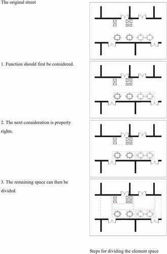
Elements exist in a spatial system by occupation of space and enclosure of space, with a certain range of surrounding spatial field. The spatial field of each element will contribute to partitioning of the area surrounding the element. This study examined how to quantitatively describe spaces to form a basic model of a specific element space system. As shown in , the formation of a complex space system should include the following steps:
Function should first be considered. Spaces that serve the same function are considered to be part of a single feature space, and the space for elements with the same function is considered to be a single element space.
The next consideration is property rights. Elements can be divided based on their different ownership based on property rights.
The remaining space can then be divided. After the element space has been divided, the remaining space on the street is then divided according to the plane figure.
Figure 2. Steps for dividing the element space
2.2.4. Shallow space
In the discussion of urban space in the Asia-Pacific region, some scholars have pointed out that compared with the strict material boundaries of western streets, there is a lack of strict distinction between public and private concepts, as traditional streets in East Asia do not have a clear division line between buildings and streets (Miao Citation2001).
The architectural space included in the analysis is called “shallow space”, and the spaces most closely connected with the street were selected. The one-step topological distance is used as the standard to select the interior spaces that are most closely connected to the street. The space of one-step topological depth is separated from the street element spaces by only the building’s exterior interface, and is not a spatial separation. Spaces one-step topological depth from the street were included as part of the architectural shallow space ().
Figure 3. Schematic diagram of shallow space
From the perspective of element space, the street shallow space and the indoor shallow space are equivalent and the Space Syntax is applicable.
3. Data analysis and interpretation
3.1. Establishment of research objects and working models
Tianzifang in Shanghai was originally a residential area. Since the introduction of art by Chen Yifei, a small-scale creative business cluster has slowly formed. Therefore, the constituent elements of the street are very rich. These constituent elements are both of residential and commercial.
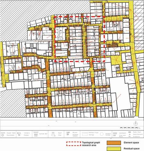
The research object is the element space network system formed by the street constituent elements, but the convex space method for space division used in traditional Space Syntax is unable to divide the element space, so is not applicable to the spatial system of street elements used here. Instead, the street space is divided using the boundaries formed by elements and combinations or elements. So, division of the street space is performed based on the element space.
As shown in the , a small change of Space Syntax – division of element space is used to divide the convex space, but Space Syntax is still applicable to the street element space. Depthmap is employed to compute the topological relationships of street elements after the street space is divided by the boundaries formed by the elements and their combinations. presents the basic data obtained by the Depthmap operations.
Figure 4. Schematic diagram of the Tianzifang working model
3.2. Analysis of integration
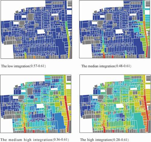
The degree of integration and distribution of the element space in Tianzifang at the microscopic-level is shown in . Judging from the distribution of the integration degree, there is no obvious distinction between street space and building space in the distribution of integration degree from high to low. On this basis, the spatial distribution of specific integration degree intervals is shown in . In specific areas, the degree of spatial integration of streets is generally higher than the degree of integration of shallow space. Overall, the degrees of integration exhibit regional distribution.
Figure 5. Distribution of integration degrees
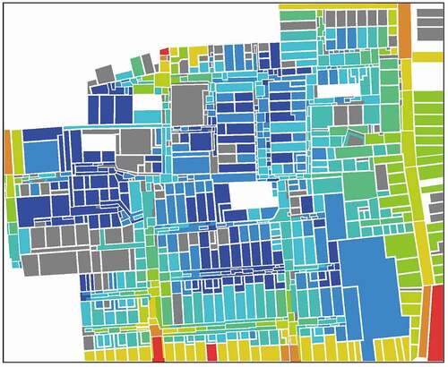
Figure 6. Spatial distribution of intervals of different integration degrees
In Space Syntax Theory, the degrees of integration reflect the accessibility of specific spaces in the space network system. Therefore, from the traditional perspective, the movement of the overall space system penetrates from streets into the buildings. When element space is taken into consideration, the movement in the global spatial system penetrates from the street near the entrances to the shallow spaces of surrounding buildings, and then enters the next area. Thus, the distribution of integration degrees exhibits a mode of point-like penetration from the street to the interior instead of linear divergence, so that a local core forms.
3.3. Analysis of synergy
The degree of synergy is a spatial syntactic measure based on the degree of integration. This is expressed by the linear correlation between the local integration and the global integration. In Spatial Syntax Theory, local integration refers to the calculation of the degree of integration of three-step topological relationships (represented by R3), and the global integration refers to the calculation of degree of integration of the global topological relationship (represented by Rn). The linear correlation between the two indicates the degree of synergy, which is used to express the degree of integration (or separation) between the local and the global.
The synergy degree of Tianzifang was calculated as shown in . The synergy degree of Tianzifang’s spatial system, R2, is 0.17 from the perspective of element space. According to empirical values, when the value of R2 is smaller than 0.5, the degree of correlation between local and global is low, so the local and the global tend to separate rather than integrate. Thus, from the perspective of element space, the Tianzifang space system is locally oriented to multi-core shaping.
Figure 7. Synergy degree of Tianzifang
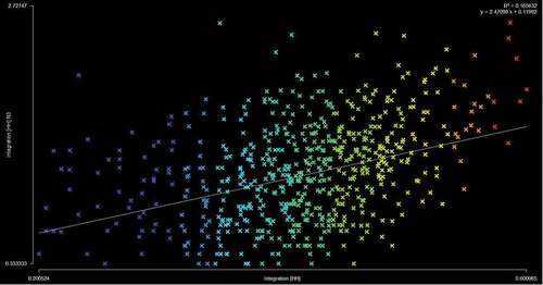
The diagonal line in indicates the trend line of the Tianzifang space network system, with linear correlation between the overall integration degree and the local integration degree. The spaces above the trend line would have a greater impact on the increasing the degree of integration between the local and the global, and the spaces below the line would have less impact.
Element spaces were selected above the trend line, below the trend line, and near the trend line, and their spatial distributions are shown in . As shown in Figures, spaces that are significantly higher than the trend line are dominated by street spaces without elements (referred to as remaining space). shows that spaces that are significantly lower than the trend line are dominated by shallow spaces that are associated with the remaining spaces. shows that the spaces located near the trend line are street element spaces and shallow spaces closely associated with element spaces.
Figure 8. Distribution of spatial units with a degree of synergy higher than trend line
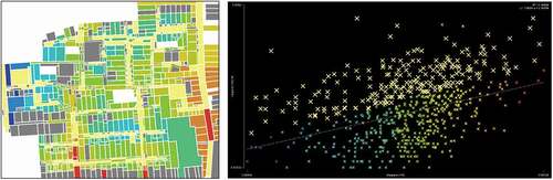
Figure 9. Distribution of spatial units with a degree of synergy lower than trend line
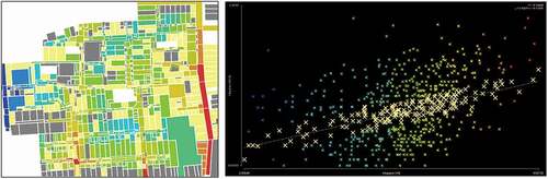
Figure 10. Distribution of spatial units with a degree of synergy near the trend line
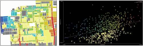
Considering that the trend line reflects the degree of the effects of the global integration degree (X-axis) on the local integration degree (Y-axis), the remaining space of the street tends to increase the impact of the overall structure on the local, and the shallow space directly associated with it tends to reduce the impact of the global structure on the local structure. The relationships between the local and the global structures of Tianzifang are best represented by the element spaces and closely associated shallow spaces.
3.4. Analysis of justified access graphs
The order of magnitude of the element unit is refined from the street level to the element level, which significantly increases the quantity and density of the elements and their connections within the same scope. As shown in , within the current selected area, the density of the elements and their connections is very close to those of Tianzifang overall. The selected area for the J-Graph is sufficiently typical to present the configuration on the element scale given that the density of the elements and their connections multiply.
To further consider the effects of the constituent elements on the street space, the central red area of Tianzifang was used as a typical object, as shown in . This area was transformed from into an Justified Access Graph () for further analysis.
Figure 11. Schematic diagram of division and connection of typical area space units
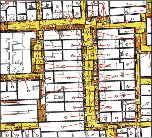
Figure 12. J diagram of typical areas
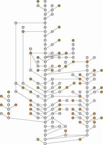
3.4.1. Illustration of elements of parallel structure
As shown in , Tianzifang’s spatial structure is dominated by small rings that are primarily formed by element spatial connections, and the small ring structures are connected in parallel to form a new local annular connection on a larger scale. Eventually these structures are connected in parallel to form larger scale rings. Thus, Tianzifang has large ring structures on various scales at different levels of elements, courtyards, and blocks. Those ring structures continuously penetrate into the internal deep structure as large rings linked with small rings. ().
Figure 13. Linear grid structures and annular parallel structures
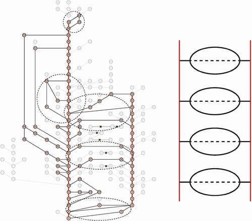
3.4.2. Classification of ring structures
As shown in the , the composition of the ring structure can be analyzed from three main perspectives: elements, buildings and streets.
element level composition of the ring structure
Figure 14. Classification of ring structures
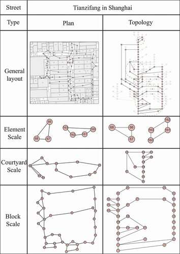
Figure 15. Proportion of constituent elements in typical regions
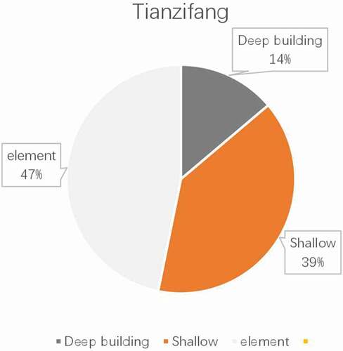
The element space is the main, and the ring structure is relatively small, there are also small ring structures composed of elements and shallow space.
(b) courtyard level composition of the ring structure
Mainly the element space and the shallow space of the building, forming a ring structure continuously penetrates into the deep space of the building. A courtyard-shaped medium-sized ring structure composed of elements, buildings, and streets.
(c) Block level composition of the ring structure
A vast space system spanning buildings and streets, consisting of element spaces, street spaces, building shallow spaces and deep spaces.
4. Conclusions
From the above analysis, three direct conclusions can be drawn, as stated below:
From the perspectives of the element space, the distribution of Tianzifang’s integration degrees is point-like mode rather than a linear mode of street-to-shop penetration.
In the Tianzifang space network system, the local and the global connections tend to be separated rather than integrated. From the perspective of element spaces, the remaining space of the street tends to increase the degree of integration. The shallow space connected to the remaining space tends to reduce the degree of integration. The element space and its closely associated shallow space have less effect. The correlations between the global and the local connections reflected in synergy graph are close to the average of the Tianzifang space network system.
The local topological connection in the J-graph suggests that the Tianzifang space network system is a ring structure composed of circular connections on different scales, rather than a linear grid structure.
Quantitative analysis of Tianzifang at the microscopic level was performed based on Space Syntax Theory. A space network system was established with constituent elements, allowing exploration of the spatial characteristics from a microscopic perspective. Space syntax theory considers urban space as a “movement system”, and the results presented here should be related to the movement characteristics of the system, as discussed below.
From the perspective of movement, the characteristics of the space network system of Tianzifang are as follows. First, at the local level, the element spaces weaken the linear characteristics of traditional streets. With circular connection, the spatial penetration of the system exhibits a point-like penetration characteristic, instead of traditional linear penetration. Second, overall, there is no difference in the accessibility between streets and buildings due to movement, and the level of accessibility is related to regional locations. Third, in terms of local and global connections, the increase of spaces with higher “traffic” attributes (remaining spaces) will increase the degree of integration between the local and the global. An increase in spaces with higher “functional” attributes (shallow space associated with remaining spaces) will increase the degree of integration between the local and the global. In terms of data, the element space and directly associated with it match the relationship between the local and the global connections of Tianzifang.
The above conclusions suggest that from the perspective of elements, the overall structure of Tianzifang includes spatial units that are connected to each other to form regional cores, and these regional cores are then connected to form a whole. The placement of elements is largely spontaneous.
For the overall Tianzifang space, there is no strict distinction between streets and buildings. From the perspective of elements, the boundaries between Tianzifang streets and buildings are weakened or dissolved to some extent. Conceptualization of this apparent dissolution of the boundaries in Tianzifang is a breakthrough in our current thinking about streets and buildings, and may facilitate further observation and discussion of a street as an “organized complexity”.
5. Prospect
Starting with the street constituent elements, the spatial characteristics of the specific case of Tianzifang were analyzed. The goal of this work was to quantitatively describe a street space from a microscopic perspective. A research model of the street space network system formed by the street constituent elements was established. Future work should address the following points:
Additional sites should be analyzed from the perspective of element spaces to assess if there are universal rules and characteristics of urban spaces.
The research methods should be optimized to determine the most appropriate quantitative description and expression method for the observation and study of street space network systems and urban spatial systems under the effects of constituent elements.
Disclosure statement
No potential conflict of interest was reported by the authors.
Additional information
Funding
References
- Alexander, C. 1965. “A City Is Not A Tree [in English].” Architectural Forum 122 (1): 58–62.
- Alexander, C. 1977. A Pattern Language [in English]. Oxford: Oxford University Press.
- Hillier, B. 1996. Space Is the Machine: A Configurational Theory of Architecture [in English]. London: Cambridge University Press.
- Jacobs, J. 1961. The Death and Life of Great American Cities [in English]. New York: Vintage.
- Kai, F., W. Xinpeng, C. Lin, Z. Zhehan, and F. Nobuaki. 2019. [in English]. Journal of Asian Architecture and Building Engineering 18 (3): 233–246. doi:https://doi.org/10.1080/13467581.2019.1627215.
- Marshall, S. 2004. Streets and Patterns [in English]. New York: Routledge.
- Miao, P., ed. 2001. The Public Space of Asia-Pacific Cities [in English]. Dordrecht: Kluwer Academic Publishers.
- Michihiro, K. 2012. “Study on Continuation of Area’S Context in Urban Formation of Prague: Typology and Transformation of “Openness” in Space Voids of Urban Blocks [in Japanese].” The Architectural Institute of Japan’s Journal of Architecture and Planning 77 (679): 2063–2072. doi:https://doi.org/10.3130/aija.77.2063.
- Salingaros, N. A. 1998. “Theory of the Urban Web [in English].” Journal of Urban Design 3 (1): 53–71. doi:https://doi.org/10.1080/13574809808724416.
- Shelton, B., J. Karakiewicz, and T. Kvan. 2013. The Making of Hong Kong: From Vertical to Volumetric [in English]. London: Routledge.
- Yoshinobu, A. 1983. The Aesthetic Townscape [in English]. Cambridge: MIT Press.
- Yu, Y., and Z. Yu. 2016. “The Raising of Quantitative Morphological Tools in Urban Morphology [in Chinese].” Urban Design 2016 (1): 56–65.