
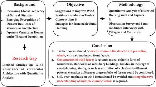
ABSTRACT
In Arakawa Village, the strong Hira downslope windstorm blowing from the Hira Mountains toward Lake Biwa, poses a great challenge for timber housing structures, which are prone to deformation. To understand the countermeasures applied in local farmhouses to mitigate the effect of wind attacks, features of historical housing and land lot layouts from the Meiji Era (1868–1912) were studied and interviews with local villagers and craftsmen were conducted. It was found that a significant majority of houses were built along the wind direction, with a closed front façade. Contrariwise, subsidiary structures, such as storage buildings and retirement houses, were placed perpendicularly to the wind direction, forming wind fences to protect the front yards, which served as agricultural workspaces. The features of spatial composition have been explained by local craftsmen as technical countermeasures; according to them, farmhouses were built on an incline of about 3–5 cm into the wind direction to mitigate deformation of timber structure. The study suggests that spatial composition of vernacular farmhouses and building techniques could offer effective strategies for sustainable rural planning and be employed to enhance the wind resistance of modern timber constructions, especially for regions prone to powerful prevailing winds worldwide.
GRAPHICAL ABSTRACT
1. Introduction
1.1. Background
In recent decades, global frequency of natural disasters has been clearly increasing, especially the climatological events (e.g. wildfire) (Abatzoglou and Williams Citation2016), meteorological events (e.g. tropical storm) (Mendelsohn, Emanuel, and Chonabayashi Citation2011), and hydrological events (e.g. flood) (Tabari Citation2020), under the impact of climate change. “The heterogenous effects of climate change are pushing architecture to recover its vernacular gaze.” (Wiegand and Simonetti Citation2020) As a result, UNESCO published a guidebook to explain lessons learned from seismic performance of non-engineered buildings with the traditional manner of construction (Arya, Boen, and Ishiyama Citation2014); flood-proof housing design was published under inspiration of vernacular architecture in the Philippines (Ham Citation2018). In Japan, the study of vernacular architecture has also gained increasing attention in recent times, to help enhance the disaster resilience of modern timber constructions against earthquakes (Kitahara et al. Citation2002), floods (Aoki and Kuroyanagi Citation2015), and winds (Ando, Kuroyanagi, and Nakamura Citation1999). This paper focuses on features of vernacular farmhouses in rural Japan against the backdrop of the Hira downslope windstorms.
However, Japanese vernacular housing structures are under threat of demolition, driven mainly by the “scrap-and-build” scheme fueled by the market economy (Uchida Citation2018). Historical records are, therefore, valuable sources to study vanishing folk houses. Yet, the studies on historical records tend to explain either village forms in relation to watercourses (Hata and Sakurai Citation2012), or village features under specific political conditions (Ito, Sasayama, and Watanabe Citation2010), and discuss natural hazards less often.
Therefore, this study provides a new perspective of quantitative analysis on historical records to understand the specific spatial composition of the farmhouses in areas that are prone to windstorms. This is further supplemented with technical explanations of underlying building techniques.
1.2. Existing studies
Ever since 1945, the effects of windbreaks were studied by many western scholars, under the impacts of periodic monsoons, from a meteorological perspective (Yoshino Citation1975). Yet in recent decades, various vernacular building techniques were studied as well, such as orientation of houses according to prevailing wind direction in Denmark (Daibaieh and Eybye Citation2016), utilization of short eaves in the Philippines (Shih Citation2019), or the storm-resistant traditional wood joint system in Vietnam (Nguyen Citation2013). Meanwhile, the wind-resistance of a hipped roof has been promoted in several studies worldwide, whether in Fiji (Caimi Citation2017), in the Philippines (Shih Citation2019) or in Vietnam (Truong Citation2014), as it could be better sealed with less traction force.
Japan is a mountainous country with complex topography and various wind types, such as downslope windstorms and gap winds, among which at least 28 local winds are known by name (Kusaka and Fudeyasu Citation2017). Therefore, the relationship between winds and livelihoods has been a popular topic among researchers in the country. However, regarding wind-resistant techniques, most studies have tended to focus on stonewall construction (Miyake and Shono Citation2005) and windbreaks (Furukawa and Yamada Citation1997), whereas only limited studies focused on features of housing and land lot layouts, or local building techniques that were developed in response to wind issues. Ando et al.’s study (Citation1999) revealed compact settlement patterns of fishing villages against wind attacks, and the research of Muramatsu (Citation1943) indicated that farmhouses in Omiya of East Japan were built along the wind direction. However, most of those exiting international or domestic studies were only based on qualitative analysis.
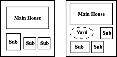
A brief introduction about basic features of Japanese farmhouses was given as follows. Studies regarding climate adaptation of rural settlements in Japan originated in the field of human geography (Saiki Citation1986). The geographer Sato (Citation1962) found that there were two patterns of housing layouts madoriFootnote1 and land lot layouts yashiki-gamae,Footnote2 depending on different geographical locations. In regard to housing layouts, a so-called main house omoyaFootnote3 tended to have all substructures directly attached to it in the northeastern regions of rural Japan, due to lower temperatures, whereas a main house in the southwestern regions tended to be a building isolated from substructures (). As for land lot layouts, the size of spare space between a main house and its substructures also varied in different regions ().Footnote4 Sometimes, little spare space was allocated, as agricultural activities were mainly carried out indoors, while in other regions, large spare space was allocated as an open agricultural workspace (Sato Citation1962). The classification was found adoptable for farmhouses in Arakawa Village, which was explained in detail in section 3.3.
Figure 1. Two patterns of housing layouts.
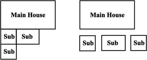
Figure 2. Two patterns of land lot layouts.
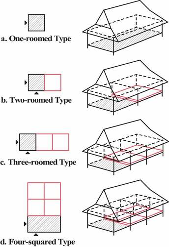
Besides, Swiss researcher Egenter (Citation1992) defined four typologies of typical housing layouts of a main house, based on the transformation process of farmhouses. They originated from a one-roomed type with an earth floor ()) and expanded to a two-roomed type with a dwelling space set on an elevated floor and separated from the earth-floored area ()). This was followed by a three-roomed type, with an expanded dwelling space divided into two rooms ()), and finally, a four-squared type, with expanded dwelling space divided into four rooms ()). This categorization offered a foundation of research methodology to classify housing layouts in Arakawa Village in section 2.3.
Figure 3. Four typologies of housing layouts. (a) One-roomed type. (b) Two-roomed type. (c) Three-roomed type. (d) Four-squared type.
Locally, two official studies have been conducted to record the features of vernacular housing structures remaining throughout the Shiga Prefecture (Shiga Prefecture Board of Education Citation1969 & 1998). Sections and floor plans of each targeted house have been duly presented based on measurement surveys, briefly introducing the house location, roof style, materiality, and certain technical details. However, researchers have focused mainly on thatched-roof houses that were well maintained; thus, only a limited number of houses with recognized high conservation value were covered in the reports. Consequently, no houses were selected in Arakawa Village. Villages that confronted natural hazards, essentially, tended to be neglected due to the necessity of frequent renovations. Moreover, the two studies merely focused on structural features of each building, with little consideration, if any, of the overall village form and the climatic context.
1.3. Study objective
By examining countermeasures adopted in vernacular farmhouses from Japan, the study aims to provide effective strategies for sustainable rural development and suggestions to improve wind resistance of modern timber constructions, for regions prone to powerful prevailing winds worldwide. The significance of the study is to provide a methodology to integrate both qualitative and quantitative study of vernacular building techniques and gain further understanding of feasible countermeasures to enhance disaster resilience of modern society.
2. Methodology
A case study in Arakawa Village, Shiga Prefecture of Japan was conducted, where strong windstorms were observed since centuries due to its specific geographic conditions (Shiga Town Kido Elementary School Citation1874). A detailed outline of Arakawa Village was explained below, which was followed by an introduction of research methodologies. Initially, historical housing and land lot layouts were interpreted through a literature review of a land register from the Meiji era. Then a quantitative analysis regarding the spatial composition of both housing and land lot layouts was conducted. Lastly, field surveys were made to verify the findings of the previous analysis with underlying building techniques.
2.1. Outline of the study area
Arakawa Village belongs to the former Shiga TownFootnote5 (hereafter, Shiga Town) in the northeast district of Otsu City, Shiga Prefecture, situated on the western side of Lake Biwa. In total, there are nine agricultural villages under Shiga Town, with a land area of 71.73 km2, measuring 15.9 km from north to south and 7.3 km from east to west (). Due to its unique geographic location between the Hira Mountain Range on the west and Lake Biwa on the east, the region experiences a significant elevation difference of up to 1,100 m within the short east-west span. Therefore, it has historically suffered frequent natural disasters, such as landslides and floods between 1615 and 1935 (Village of Kido, History of Shiga Town, Shiga Prefecture Disaster Journal).Footnote6 This has now been remarkably remedied by the construction of stone dikes and dams.
Figure 4. The map of Former Shiga Town in the Meiji Era.
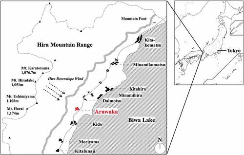
However, a strong mountain downslope windstorm called Hira-oroshi still occurs, posing a threat to the villagers throughout the year. A downslope windstorm usually requires a steep leeside slope and a mountain height of about 1 km or more (American Meteorological Society Citation2016). The Hira Mountain Range includes a series of steep mountains with a height of over 1,000 m, among which Mt. Horai towers at 1,174 m, followed by Mt. Uchimiyama at 1,108 m, Mt. Karatoyama at 1,076.7 m, and Mt. Hiradake at 1,051 m. Heavy Hira windstorms from the Hira Mountains toward Lake Biwa were observed especially from March to May, and from September to November (Matsui and Takeda Citation2001), reaching a maximum speed of up to 50 km/s, or sometimes lasting through half of a day at 20 km/s (Oku and Iriyama Citation2020).
Consequently, Hira windstorms resulted in frequent damage to buildings, school closures, delays or suspension of railroad services, and even traffic accidents, such as truck overturns (Furumoto and Yamada Citation2014). Meanwhile, as a commuter town for city dwellers, Shiga Town has grown rapidly in accordance with the boom of urban migration, especially from the 1960s to the 1990s (Takahashi Citation2010). Natural hazards and a lack of understanding of the local climate have posed great challenges to the durability of its modern timber houses, causing ongoing worries, such as the violent shaking of houses in windy seasons, for the new inhabitants.
Arakawa Village is well known among the locals for facing more severe windstorms than the other eight villages; thus, it was targeted as the research site to study the features of traditional farmhouses and to examine vernacular building techniques that were developed to withstand the Hira downslope windstorms.
2.2. Interpretation of historical land register
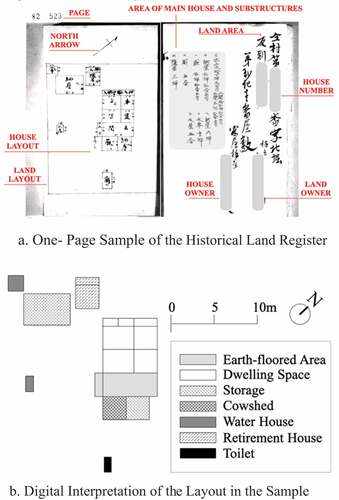
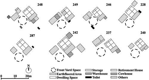
With assistance from professionals, the land register of Arakawa Village from 1899Footnote7 was interpreted. The housing and land lot layouts for each household were carefully recorded, together with some administrative information regarding house number, land and house area, and the names of the house owners, and sometimes, the landowners as well (). Mapping of the historical housing layouts was then completed based on the house numbers obtained. In total, it included 61 land lot layouts, which comprised 46 private households, one temple, one community house, 10 storages, one water house, and two retirement houses – the last 3 being substructures. Layouts of farmhouses were the main research targets for the layout study.
Figure 5. Study of the historical land register (a, b). (a) One- page sample of the historical land register. (b) Digital interpretation of the layout in the sample.
2.3. Analysis of housing layouts
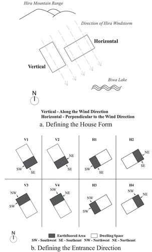
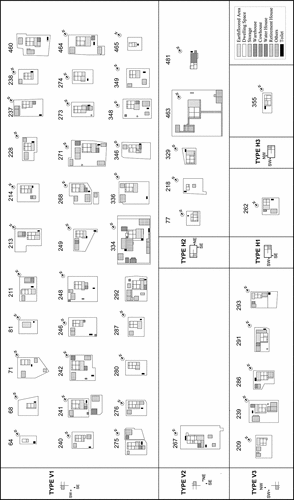
Features of housing layouts were analyzed through a classification of housing layouts into eight typologies. Houses in Arakawa Village were observed to either have ridges extending along the wind direction (vertical house form) or perpendicularly to the wind direction (horizontal house form) ()). Therefore, in combination with four directions of house entrance (namely from south, east, north, or west), eight types of house orientations were defined in total, where each type provided two entrance possibilities, as they could be accessed either from the gable end, called tsumairi, or from the eave side, called hirairi ()).
Figure 6. Eight typologies of housing layouts (a, b). (a) Defining the house form. (b) Defining the entrance direction.
2.4. Analysis of land lot layouts
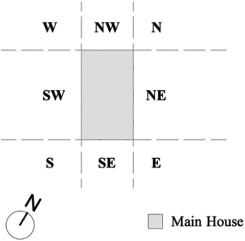
Features of land lot layouts were analyzed based on the positions of substructures in relation to a main house in eight different directions (). Thus, tendency of substructure distribution in specific relative positions to a main house could be understood.
Figure 7. Eight possible relative positions of substructures to a main house.
2.5. Field surveys
In total, field surveys of the study comprised an observation survey and six semi-structured interviews with three senior villagers (S, Y1, Y2) aged over 80, one villager (Y3) aged over 60, and three craftsmen (K, N, U), during the period from December 2019 to February 2021.
The observation survey assessed the current condition of targeted farmhouses and examined the consistency of house orientation with that in the Meiji era. Interviews with local villagers then helped evaluate the consistency between the past and the current housing layouts. As we could not find any craftsman in Arakawa, craftsmen from neighboring villages were interviewed. Interestingly, craftsmen from Shiga Town share similar building techniques to this day, regardless of their geographical origins within the town. The aim of these interviews was not only to gain a better understanding of the features observed from the historical housing and land lot layouts, but also to explore other wind-resistant building techniques.
3. Results
First, based on interpretation of the land register from the Meiji Era, features of the overall village form were explained. Second, by examining the distribution of housing layouts under the eight typologies, features of housing layouts, especially house orientation and housing layouts were understood. Third, based on the study of substructure distribution, features of land lot layouts were explained. Fourth, findings of housing and land lot layouts were further verified with underlying building techniques explained by local craftsmen, with some other wind-resistant techniques being explored as well.
3.1. Features of the historical settlement pattern
Based on the mapping analysis (), it was found that Arakawa Village belonged to a typical clustered settlement pattern, with the temple and the community house sitting in the central village area. Initially, houses were built compactly near the temple and the village center, while some family members were given individual land properties some distance away. The border of the village was fenced with a stonewall called shishigaki to protect farm fields from wild boars and deer. Currently, tracks of stonewalls in other villages under Shiga Town barely remain and are difficult to locate. The stonewall in Arakawa Village, however, has been well maintained, as it also served as protection against floods originating from the Otani River in the past. Thus, natural disasters exerted such impact on the village form that the housing layouts tended to be simplified from the four-squared type at the southwestern side to the one-, two-, or three-roomed types at the northeastern side of the village, which was closer to the Otani River and was more prone to floods during rainy seasons. Historically, the area was regarded as abandoned land and even agricultural activities were prohibited, as recorded in cadastral maps (Otsu City Museum of History).
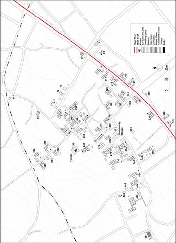
Figure 8. Mapping of Arakawa Village in the Meiji Era.
3.2. Features of housing layouts
3.2.1. Impact of the Hira downslope windstorm
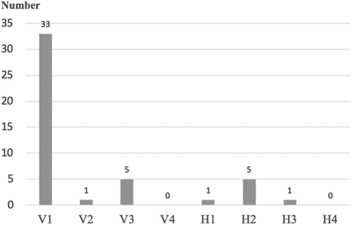
Statistically, the majority of main houses in the Meiji Era belonged to the vertical house form (V1, V2, V3), making up a total percentage of 84.8%, while only seven houses were in the horizontal form (H1, H2, H3) (). 71.7% of all houses were constructed in the Type V1 house form, while 10.9% of the houses followed Type V3 and Type H2 house forms, respectively. The distribution indicated that a significant majority of the houses were placed along the wind direction, with a south-facing house entrance.
Figure 9. Distribution of types of house orientation.
The same feature of house orientation was observed in the modern era. Results of the observation survey revealed that 92.9% of the houses, rebuilt by local craftsmen and remaining in vernacular timber structures, were still oriented along the wind direction, which is even larger than the proportion of 84.8% in the Meiji Era. Additionally, all seven Meiji-Era houses under a horizontal house form (H1, H2, H3) had either been demolished or rebuilt in a vertical house form in the modern era ().
Table 1. Current condition of horizontal housing layouts.
Thus, in both Meiji and modern eras, it was proved that houses were built along the northwest-southeast axis following the wind direction.
As for the housing layouts, it was observed that 76.1% of houses had been developed into the four-squared type in the Meiji Era (), while 96.3% of four-squared houses attached with rooms that required no natural lighting― an alcove and an altar in the guest room, as well as a closet in the sleeping room ().
Figure 10. Distribution of types of housing layouts.
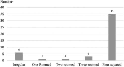
Figure 11. Layouts categorized into six types.
Through interviews with local seniors, it was understood that the recessed alcove was called tokonoma, where calligraphic or pictorial scrolls were presented, and the delicate altar was called butsudan, used for paying respects to the Buddha and deceased family members. The closet in the sleeping room was used to store mattresses (). To further validate that the room partitions near the front façade were a specific countermeasure against wind attacks rather than merely a cultural custom of the region, Type V3 with inverted housing layouts was studied as well. Interestingly, in these cases, only 20% of the households followed the custom of placing alcoves, altars, and closets simultaneously on the end of the dwelling space (). Therefore, the adoption of a closed front façade was rather in consideration of the windstorm issues than merely a cultural obligation.
Figure 12. A typical four-squared housing layout under Type V1.
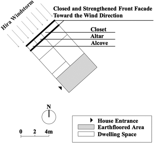
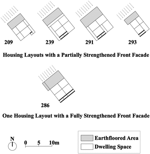
Figure 13. The five housing layouts under Type V3.
In conclusion, a majority of houses in Arakawa Village were oriented towards the wind direction and built based on the four-squared housing layout. Houses that were not built along the wind direction in the Meiji Era have now been reoriented, with the overall percentage of the vertical house form increasing from 84.8% to 92.9%. 96.3% of four-squared houses had a closed front façade to mitigate the effect of wind attacks. This was realized by arranging rooms that required no natural lighting at the end of the dwelling space, reflecting the impacts from local climate and cultural custom at the same time.
3.2.2. Impact of sunlight and water accessibility
Another important factor influencing the housing layouts was sunlight. As mentioned earlier, most of the houses had their entrances toward the south to allow as much sunlight as possible into the earth-floored area, which was utilized as a working space. However, no house belonged to Type H4 or V4, indicating that an entrance toward the north, which had little sunlight, was not preferred.
Additionally, water accessibility played a significant role. Numerous watercourses flowing from the deep mountainous area into Lake Biwa basically overlap with the road network to this day. In the past, they served as important water sources for drinking, cooking, laundry, and field irrigation. As 80% of Type V3 houses had the watercourses to their northwest side, an inverted housing layout was preferred to ensure easy accessibility of the earth-floored area to a watercourse since it was significant for the functioning of the kitchen.
Therefore, it was understood that the amount of sunlight determined the entrance direction for farmhouses and ease of accessibility to a watercourse was prioritized over windstorm issues in housing layouts if necessary.
3.3. Features of land lot layouts
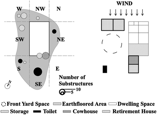
Land lot layouts in Arakawa Village corresponded to the land lot pattern with one open agricultural workspace, which was surrounded by a main house and several isolated substructures, as mentioned in section 1.2 ().
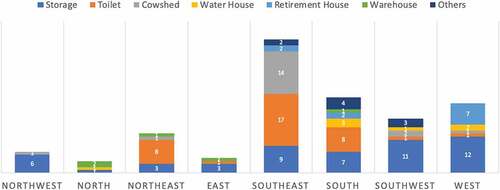
The total number of substructures reached 179, among which Type V1 houses made up the greatest number of substructures at 139, followed by the V3 type at 23 substructures, H2 at 7, V2 with at 6, H1 at 3, and H3 with only one substructure. Therefore, we focused on Type V1 in order to determine the overall features of land lot layouts. Under Type V1, the number of individual substructures located at a relative position to a main house was calculated (). The largest proportion of substructures, 31.7%, could be observed in the southeast direction, mainly comprising toilets (38.6%), cowsheds (31.8%), and storage buildings (20.5%). Meanwhile, 18.0% of buildings were in the south direction and mainly comprised toilets (32.0%) and storage buildings (28%). Similarly, 16.5% of substructures were in the westerly direction and comprised storage buildings (52.3%) and retirement houses (30.4%). The distribution of main substructures with respect to windstorm issues is explained in the following section below.
Figure 14. Number of individual substructures in each relative position to a main house under Type V1.
3.3.1. Impact of the Hira windstorms
The most dominant feature of land lot layouts under the impact of Hira windstorms was the distribution of storage buildings and retirement houses. Storage buildings were used for storing crops, farm tools, and daily necessities, whereas retirement houses were prepared as separate living and sleeping rooms for senior retired family members. Statistically, 45.8% of the storage buildings under Type V1 tended to be located in the southwest and west directions (). Among the 11 retirement houses, 63.6% were located in a westerly direction. Specifically, storage buildings and retirement houses in the southwest and west directions tended to be placed perpendicularly to a vertical main house, thus forming wind fences to protect the open space in front of the house entrance. The open space, together with the interior earth-floored area, served as agricultural workspaces for various activities, such as threshing rice and drying vegetables (). In total, 58.9% of all housing layouts were found to follow this pattern in the Meiji Era.
Figure 15. Distribution of storage buildings.
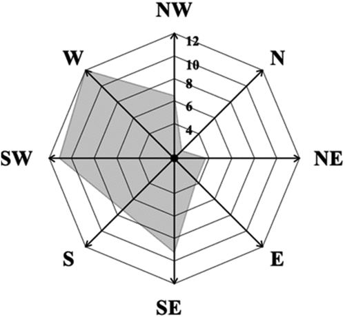
Figure 16. Examples of houses with a protected front yard.
Another feature related to windstorms was the direct attachment of substructures, such as storage buildings and cowsheds, to a main house in the southeast direction. In the pre-industrial era, cows were important labor forces for agricultural activities and regarded as an integral part of the households. Statistically, 18.8% of storage buildings were placed in a southeast direction, among which 55.6% were found to be directly attached to a main house. 82.4% of cowsheds were placed in a southeast direction, among which 76.5% were directly attached to a main house. Direct attachment of cowsheds not only increased the convenience of feeding the cows, but also helped to strengthen the timber framework of a main house, as explained in detail below (Section 3.4).
In short, it was found that most of the storage buildings and retirement houses were placed horizontally in the southwest and west directions to form long wind fences for the front yard as an agricultural workspace, while the storage buildings and cowsheds on the southeast side tended to be directly attached to a main house to strengthen the timber framework against wind attacks ().
Figure 17. Distribution of main substructures (left) and a typical sample of land lot layouts (right).
3.3.2. Impact of sunlight
Similar to the south-facing house entrance, the front yard also required sufficient sunlight and thus was located southwest of a main house. It eventually resulted in storage buildings and retirement houses being concentrated in the southwest and west, as mentioned above. In contrast, a Type V2 house, which was a part of the land property of a local temple, did not serve as a typical farmhouse and therefore, had its house entrance toward the east, without requiring a south-facing front yard. Additionally, toilets, as important sources of fertilizer for the paddy fields in the past (Brown Citation2013), tended to be located in southeast and south directions, with a total percentage at 72.7%, as a relatively warm temperature helped quick fermentation of excrements (Ikuko Citation2010). Therefore, it was understood that abundant sunlight also played a role in the distribution of substructures, resulting in the south-facing front yards and toilets.
3.4. Countermeasures explained by craftsmen
Through interviews with local craftsmen, findings based on the historical layouts were verified and various other local building techniques with regard to the windstorm issues were also explored.
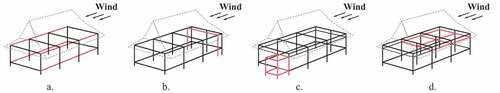
Houses were oriented along the wind direction and had a closed front façade, not only to minimize the extent of wind attacks, but also based on the fact that a timber structure could bear more external forces directed along a length axis ()). Further, the front façade could be structurally strengthened by an additional framework of room partitions of alcoves, altars and closets mentioned above ()). Similarly, attaching some substructures (e.g. cowsheds, storage buildings) to a main house also strengthened the main timber structure against attacks along the wind direction ()). Heavy lintels, called sashikamoi, with large depths of between 25 cm to 40 cm, were utilized to improve the overall structural performance as well ()).
Figure 18. Countermeasures utilized to strengthen the structural performance.
In particular, it was mentioned that the timber structure was built inclined into the wind direction to regulate deformation under the impact of Hira windstorms. The building process was explained in detail as follows ():
Figure 19. Construction process of the timber framework inclined toward the wind direction.
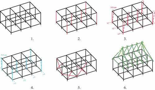
Assemble the basic timber framework.
Define the columns in the center and at the corners of the structure as “main columns” and visually confirm the inclining direction, which should be “toward the mountains.”
Push or pull the main columns along the length axis from the border to the interior, e.g. from the columns at the axes x1 and x 3 to those at the axis x 2. Use plumbs to confirm the deviation distance at about 3–5 cm, with an inclination of about 1° (degree).
Similarly, push or pull the main columns along the width axis, e.g. from the axes y1 and y4 to y2 and y3.
Utilize diagonal struts to fix the deviation when reaching the expected inclination.
Assemble the roof structure and remove the diagonal struts after stabilizing the whole structure by knocking in the pinsFootnote8 to close the joinery of the timber framework.
This tacit technique inherited among craftsmen is still used today in construction projects in Shiga Town without any textual indications or verbal instructions from the architects
4. Conclusion
Based on both quantitative analysis of layouts and qualitative interviews with villagers and craftsmen, this paper aims to enhance a comprehensive understanding of wind-resistant countermeasures adopted in local farmhouses, from spatial composition of layouts to building techniques. In the following, suggestions were made based on individual research findings accordingly.
In the Meiji Era, to withstand strong Hira windstorms, most of vernacular housings in Arakawa Village were built along the wind direction (the northwest–southeast axis) with a closed front façade. The houses that did not follow the wind direction were either demolished or reoriented by the wind axis in the modern era. This served to minimize the affected areas under wind attacks and to maximize the resistance of a timber structure against external forces along the wind direction. Therefore, it is suggested that, in regions prone to powerful prevailing winds, timber houses should be oriented toward the wind direction, possibly with a strengthened front façade. Based on the optimal building form in regard to wind direction, reasonable design of new residential plots during rural planning should be emphasized.
As for substructures, most storage buildings and retirement houses in Arakawa Village were found to be placed southwest and west of a main house, forming long wind fences to protect the front yard. Thus, for new houses that require an open area as a multifunctional workspace, it is recommended to have wind fences built in advance, either with windbreaks, stonewalls, or subsidiary buildings. Besides, strategies to form wind fences could also be adopted in the stage of rural planning, such as utilization of a clustered settlement pattern, elevation differences or green belts of forests.
Still, it is noted that though the Hira downslope windstorms have been a prominent factor that shaped the historical housing and land lot layouts in Arakawa Village, spatial composition of vernacular farmhouses also represented local wisdom in comprehensive consideration of sunlight and water accessibility. Therefore, over-emphasis on one climatic issue should be avoided and integration of multiple climatic factors (e.g. wind, sunlight and water) is required for sustainable rural planning.
Limitations of the study, first of all, lie in the limited number of interviewees, including senior villagers and craftsmen, that possess relevant knowledge and willingness to cooperate. Difficulties of home visits increased especially after outbreak of the pandemic, so that a quantitative analysis of vernacular building techniques in current housing layouts could not be conducted. Second, findings of the study are only adoptable for regions with prevailing winds from one main direction. Third is the necessity of further structural assessment to verify the effects of an inclined timber structure. The construction process of houses with an inclination of about 3–5 cm into the wind direction, were explained by local craftsmen. This vernacular building technique has proposed a unique perspective of appreciating the elasticity of timber structure and creating buffer zones against natural hazards. Therefore, subsequent research is recommended for engineering scientists with similar interests.
Acknowledgments
The authors would like to express deep gratitude to the villagers for sharing their knowledge and wisdom with us during the field surveys. This research was supported by the Eco-DRR Project (No. 14200103) of Research Institute for Humanity and Nature.
Disclosure statement
No potential conflict of interest was reported by the author(s).
Additional information
Funding
Notes on contributors
Jingying Wang
Jingying Wang is a Master student at Kyoto University, Japan. She received the B.Sc. Degree in architecture and urban planning from University of Stuttgart, Germany. Her research interests lie in vernacular architecture and ecosystem-based disaster risk reduction (Eco-DRR).
Chiho Ochiai
Chiho Ochiai is an Associate Professor at Global Environmental Studies, Kyoto University, Japan. She received Ph.D. from Kyoto University. Her research interests are community-based disaster management and traditional/regional knowledge.
Notes
1 Madori indicates the room plan of a house and is translated as “housing layout.” In the paper, it refers specifically to the room plan of a main house.
2 In contrast to madori, yashiki-gamae indicates the spatial composition of a land lot and is translated as “land lot layout.” It focuses on the features of the relative positions between a main house and its substructures.
3 Omoya indicates a main house where family members lived and carried out daily activities; in contrast, substructures, such as storages, warehouses, and cowsheds, were separate building unites with various specific purposes.
4 The two diagrams aim to explain the concept without corresponding to the exact position and proportion of houses and substructures in reality.
5 The former Shiga Town served as an independent administrative unit from 1955 to 2006, which was abolished when the villages were united into the city of Otsu until today.
6 Titles of the three references are translated by the author. The original titles are Kido-no-Sato(Shiga Town Kido Elementary School Citation1874), Shigachou-shi (Editorial Board of the History of Shiga Town Citation2002) and Shiga-ken-Saigai-shi (Shiga Prefecture Citation2011) in Japanese.
7 The original title of the land register is Tatemono-Daicho in Japanese. Copies are offered by the Otsu City Museum of History.
8 A pin, or sen in Japanese, is made of hardwood, usually oak in the Shiga region. It would be added to angle joints shiguchi or end joints tsugite for purpose of tightening and strengthening the structure.
References
- Abatzoglou, J., and P. Williams. 2016. “Impact of Anthropogenic Climate Change on Wildfire across Western US Forests.” PNAS 103 (42). doi:10.1073/pnas.1607171113.
- American Meteorological Society. 2016. “Glossary of Meteorology.” http://glossary.ametsoc.org/wiki
- Ando, R., A. Kuroyanagi, and S. Nakamura. 1999. “A Study on the Living Space Characteristic of Fishing Villages on Coastal Zone Which under Strong Wind.” Journal of Achitecture Planning and Environmental Engineering 64 (520): 107–144. ( in Japanese). doi:10.3130/aija.64.107_3.
- Aoki, H., and A. Kuroyanagi. 2015. “A Study on A Local, an Architecture and the Inhabitant’s Life in the Flood Area.” Journal of Architecture and Planning 80 (717): 2569–2576. ( in Japanese). doi:10.3130/aija.80.2569.
- Arya, A., T. Boen, and Y. Ishiyama. 2014. Guidelines for Earthquake Resistant Non-engineered Construction. Paris: UNESCO.
- Brown, A. 2013. Just Enough - Lessons in Living Green from Traditional Japan. Tokyo: Tuttle Publishing.
- Caimi, A. 2017. Local Building Cultures for Sustainable and Resilient Habitats - Fiji, 6. Genf: International Federation of Red Cross and Red Crescent Societies (IFRC). https://www.humanitarianlibrary.org/sites/default/files/2018/12/fiji_-_country_profile_-_local_building_cultures_for_sustainable_and_resilient_habitats_-_20170920.pdf
- Daibaieh, M., and B. T. Eybye. 2016. “A Comparative Study of Human Aspects in Acclimatization of Adobe Vernacular Architecture: A Case from Denmark and Egypt.” A|Z ITU Journal of Faculty of Architecture 13 (1): 29–41. doi:10.5505/itujfa.2016.09709.
- Editorial Board of the History of Shiga Town. 2002. Shigacho Shi (History of Shiga Town). 3 vols. Shiga Town (Shiga Prefecture): Shiga Town. ( in Japanese).
- Egenter, N. 1992. “The Modern Western Concept of Homogenous Space and the Archetype of “Polar Harmonious Space” – Comparative Intercultural Research into the Spatial Structure of the Traditional Japanese House.” Third Conference of the International Association for the Study of Traditional Environments, Paris, France. http://home.worldcom.ch/~negenter/412JapHouseFigE1.html
- Furukawa, N., and M. Yamada. 1997. “The Form of Windbreak Forest and the Effects of the Protection against Wind in Okinawa.” Journal of Architecture Planning and Environmental Engineering 62 (494): 105–112. ( in Japanese). doi:10.3130/aija.62.105_1.
- Furumoto, J., and Higashi, K. 2014. “Advanced Atmospheric Observations for Confronting Disasters and Their Contribution to Society.” Sustainable Humanosphere 10: 23–27. (in Japanese). http://hdl.handle.net/2433/196738
- Ham, P. 2018. “Vernacular Architecture Inspires Flood-proof Housing.” TU Delft DeltaLinks.
- Hata, K., and Y. Sakurai. 2012. “The Arrangement of the Farmhouse in the Middle Meiji Period, the Spatial Composition of the Village’s Residential Area on the Typical Settlement.” Journal of Architecture and Planning 77 (675): 1061–1068. ( in Japanese). doi:10.3130/aija.77.1061.
- Ikuko, K. 2010. Daidokoro o Kawa wa Nagareru (Rivers Flowing through the Kitchens). Tokyo: Shinhyoron Publishing. ( in Japanese).
- Ito, H., H. Sasayama, and Y. Watanabe. 2010. “A Study on Restoration of Site of Barrier and Formative Process of Kamiashigawa Settlement.” Journal of Architecture and Planning 75 (656): 2499–2506. ( in Japanese). doi:10.3130/aija.75.2499.
- Kitahara, A., Y. Hayashi, T. Okuda, Y. Suzuki, and M. Goto. 2002. “Structural Characteristics and Earthquake Damage of Wooden Houses in the 200 Western Tottori Earthquake.” Journal of Structural and Construction Engineering 67 (561): 161–167. ( in Japanese). doi:10.3130/aijs.67.161_3.
- Kusaka, H., and H. Fudeyasu. 2017. “Review of Downslope Windstorms in Japan.” Wind and Structures 24 (6): 637–656. doi:10.12989/was.2017.24.6.637.
- Matsui, K., and H. Takeda. 2001. “Local Wind in the Omi Basin as Observed from Biwakodas.” Biwakodas Research Short Report, no. 2. https://koayu.eri.co.jp/biwadas/report/matsui_report2.pdf
- Mendelsohn, R., K. Emanuel, and S. Chonabayashi. 2011. The Impact of Climate Change on Global Tropical Storm Damages. World Bank Finance Economics and Urban Department, Global Facility for Disaster Reduction and Recovery. https://library.wmo.int/index.php?lvl=notice_display&id=6628#.YUBMZNMzYWo.
- Miyake, M., and T. Shono. 2005. “The Preservation of Stone Infrastructures and Wall Structure Using Locally Produced Stones – A Case Study on Sotodomari in Ehime.” Infrastructure Planning Review 22: 371–378. ( in Japanese). doi:10.2208/journalip.22.371.
- Muramatsu, S. 1943. “On the Relationship between Wind and Residence in Japan.” Journal of Geography 55 (11): 413–421. ( in Japanese). doi:10.5026/jgeography.55.413.
- Nguyen, H. M. 2013. “Cultural Behavior: Climatic Adaptive Approaches of Traditional Housing in Vietnam Northern Lowland Area.” Procedia – Social and Behavior Sciences 85: 368–382. doi:10.1016/j.sbspro.2013.08.366.
- Oku, Y., and T. Iriyama. 2020. “A Case Study of the Local Downslope Wind “Hira-oroshi” by Using Numerical Weather Prediction Model.” Research Reports 22: 29–35. ( in Japanese). http://id.nii.ac.jp/1214/00005869/
- Saiki, T. 1986. “Formation Principles of the Spatial Structure of Agricultural Settlements, with Special Reference to Topography.” Journal of Rural Planning Association 4 (4): 19–32. ( in Japanese). doi:10.2750/arp.4.4_19.
- Sato, J. 1962. “Architectural Structure of Farmhouses and Style Arrangement.” Japanese Journal of Human Geography 14 (6): 445–464. ( in Japanese). doi:10.4200/jjhg1948.14.6_445.
- Shiga Prefecture. 2011. Shiga Ken Saigaishi (Shiga Prefecture Disaster Journal). 5 vols. Otsu: Shiga Prefecture ( in Japanese). Otsu: Shiga Prefecture.
- Shiga Prefecture Board of Education. 1969 & 1998. Shiga Ken Kinkyu Minka Chosa Hokokusho (Emergency Housing Survey Report of Shiga Prefecture). ( in Japanese)
- Shiga Town Kido Elementary School. 1874. Kido-no-Sato (Village of Kido). ( In Japanese). Shiga Town (Shiga Prefecture): Shiga Town.
- Shih, R. R. L. 2019. Ocho Balay: The Design and Developmental Construction of a Typhoon Shelter for the Rural Areas in the Philippines. Pécs: University of Pécs. https://pea.lib.pte.hu/bitstream/handle/pea/19347/rowell-ray-lim-shih-phd-2019.pdf?sequence=1&isAllowed=y
- Tabari, H. 2020. “Climate Change Impact on Flood and Extreme Precipitation Increases with Water Availability.” Scientific Reports 10: 13768. doi:10.1038/s41598-020-70816-2.
- Takahashi, S. 2010. Nihon no Shishigaki (The Stone Wall in Japan), 142–166. Tokyo: Kokon Shoin. ( in Japanese).
- Truong, N.-H.-L. 2014. “Lessons from Climatic Response in Vietnamese Vernacular House.” Journal of Civil Engineering and Environmental Technology 1 (2): 41–46.
- Uchida, S. 2018. Meaning and Value of Inheriting Japanese Houses, 2–6.7. Tokyo: JUSOKEN “Inherited Housing” Research & Investigation Committee.
- Wiegand, E., and C. Simonetti. 2020. “OXFORD Urbanists.” Vernacular Architecture and Climate Change. Accessed 2 July 2021. https://www.oxfordurbanists.com/oxford-urbanists-monthly/2020/1/5/vernacular-architecture-and-climate-change
- Yoshino, M. 1975. Climate in a Small Area – An Introduction to Local Meteorology, 142–147. Tokyo: University of Tokyo press.