
ABSTRACT
Since the implementation of Chinese Western Development Strategy, gully regions of the Loess Plateau experience rapid development. Large number of residents living in gullies move to tableland, village combination and extension come to be a common phenomenon. Due to the neglect of ecological carrying capacity evaluation and the lack of scientific methods for human settlement planning, the unreasonable village combination and extension cause severe damage for the natural environment, low quality living environment, large waste of resource and lots of unnecessary investment. In this paper, cultivable land, water resource and infrastructure are figured out as three important limiting factors for the ecological carrying capacity evaluation. Grid computing method is used to draw distribution maps for each factor. After overlaying these distribution maps, the space distribution of ecological carrying capacity can be visualized. Tao Qu Yuan village is chosen as a research object for its high ecological carrying capacity. According to the ecological carrying capacity evaluation, the priority areas for new immigrants can be fixed, natural resource and social resource can be saved, and investment for new construction can also be reduced. Results summarized by this method can be used as guideline for the future village planning.
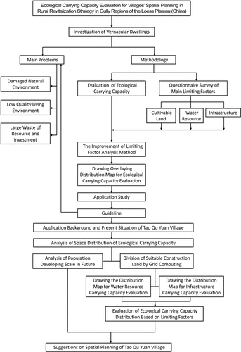
GRAPHICAL ABSTRACT
1. Introduction
1.1. Regional issues
After the Chinese reform and opening up, especially since the implementation of the western development strategy, the process of urbanization in gully regions entered a rapid development period by the soil and water conservation policy, ecological environment construction efforts, and rising social productive forces. Same as other areas in China, gully regions of the Loess Plateau are also experiencing a huge change in its social, economic and ecological development. Along with “urban disease”, such as congestion, air pollution, property bubbles, high living costs, and land waste, “Rural diseases” are also very common and more urgent to be solved, including population outflow, abandoned land, industry recession, culture decline, and environmental pollution in the degrading countryside (Liu, Li, and Yang Citation2018, 5–14).
The Loess Plateau is located in the Midwest of China, covered with 30 m-300 m thick calcareous yellow soil, it is one of the earliest human settlement and the most fragile ecological areas in China (Zhang Citation1993). The area is about 530 thousand square kilometres, accounting for 1/l8 of total Chinese territory. Gully regions of Loess Plateau are one of the subtype regions and natural geographical units, which are located in the southern part of the Loess Plateau, including 7 cities, 18 counties, a population of about 4.3 million, and a total area of about 14.8 thousand square kilometres (Cao, and Zhou Citation2008 015) as shown in and .
Figure 1. Location of gully regions.
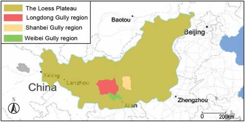
Table 1. Space distribution in gully regions of the Loess Plateau.
Compared to other regions in Loess Plateau, although it is full of gullies with serious soil erosion, broad tableland area is suitable for farming, which make it a population dense area. The distribution of villages in this region is dispersed and own obvious local characteristics (Shi Citation2001). Since 2005, the construction of new socialist countryside carried out in the Loess Plateau, human settlements enter a drastic transformation period. The quality of natural resources has been exposed to significant degradation from increased urban populations combined with the sprawl of settlements, development of transportation networks and industrial activities (Long et al. Citation2011, 1094–1105).
Due to the neglect of ecological carrying capacity evaluation and the lack of a scientific method for human settlement planning, the unreasonable village combination and extension cause several issues. The Rural Vitalization Strategy proposed the “large centralized” development model, which means combining the dispersed villages together. In short term, the development model appears to have outstanding advantages by effectively improving the appearance of villages and realizing the rapid development of the rural economy and society on the surface. However, the neglect of the reasonable village spatial planning and evaluation causes the severely damaged for the natural environment, low quality living environment, large waste of resource and lots of unnecessary investment (Wei Citation2019). In 2020, in the Journal of China Land Sciences, the method of double evaluation for spatial optimization: environmental resource carrying capacity evaluation and land developing suitability evaluation, has been explained and the operational technology route has been submitted (Jia et al. Citation2020). In recent years, government pays more attention on environment carrying capacity, and this double evaluation for land spatial optimization will be acted as guideline for future land planning. The results of this paper own the same meanings with national land planning requirement, the local government took part in the whole research process and adopt it as reference for local land planning.
1.2. Research background
Rural habitats, as the smallest social unit in gully regions of the Loess Plateau, are home to a large amount of the agricultural population (Shaanxi Province Bureau of Statistics Citation2014). The science of human settlements planning has been established since the 1960s with the gradual complication of human settlements. The concept of the science of human settlements was first proposed by the Greek scholar (Doxiadis Citation1970, 393–404). In 1961, the World Health Organization (WHO) proposed four basic concepts for the living environment: safety, health, convenience, and comfort. A series of international conferences has been conducted to discuss the issue of human settlements and the environment. (United Nations (UN) Citation1972, Citation1976, Citation1996, Citation2016.)
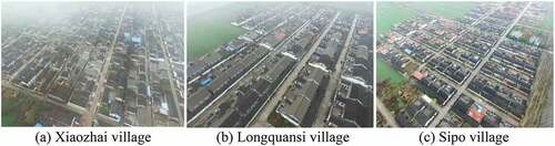
Nowadays, large numbers of residents live in gullies move to tableland (Yu, Zhou, and Liu Citation2005, 189–193). On the one hand, this has caused the disappearance of the slope villages and gully villages (Yu Citation2007); on the other hand, it has increased ecological pressure on tableland, which was originally densely populated and made the original weak ecological environment much worse (Liu et al. Citation2015, 173–181; Meier Citation1978, 1–27). In the process of urbanization there are a series of related issues appeared in the rural planning, such as the waste of resources, unreasonable population distribution and village combination, the common phenomenon all villages come to be the same outlooks as shown in by blindly pursuit the centralized usage of land and resource.
Figure 2. The same outlook of villages in Qianyang County. (a) Xiaozhai village. (b) Longquansi village. (c) Sipo village.
All of these force us to figure out a suitable development model and sustainable village planning methods. Therefore, based on the analysis of ecological carrying capacity, the full understanding of its distribution can help us to better plan the future villages. In the previous research, according to the maximum ecological carrying capacity, current carrying capacity and current population, villages are classified into different grades to decide which villages have the potential to support more immigrants, which ones should be integrated with others after improvement of present conditions, and which villages should be moved. Following these previous research, the villages can be extended and improved and should be further researched to realize the most suitable reconstruction.
1.3. Literature review
The systematic research of living environment is the only research system superior to architectural research (Ahnad and Lutz Citation1989, 118). The analysis of ecological carrying capacity used in rural living environmental planning is the necessary step for implementing living environment construction. Hu, Feng, and Chen (Citation2006, 11–17) optimized an optimization system for improving rural living environment by drawing safety network map and making related priority index. Wang and Zhang (Citation2010, 126–130) took Zhou Zhi County of Xi’an as example, optimized the village ecological construction philosophy combined with natural geographic environment, through the analyses the relationship between villages’ distribution and natural environment in Qin Lin Mountain, and the relationship between natural ecological environment and residential habitat construction. Mao et al. proposed the basic conception and research method for village ecological infrastructure, and established index system, which layouts the scientific base for future rural planning and sustainable development (Mao, Li, and Xu Citation2010, 120–122).
At the same time, there is also related research on the evaluation of rural ecological carrying capacity. Liu et al. used carrying capacity analyses in the research of ecological habitats of gully regions of the Loess Plateau, submitted unit safety evaluation index (Liu and Dong Citation2006, 76–80). Yu et al. proposed the land suitability evaluation system during the site investigation in gully regions of the Loess Plateau (Yu, Guo, and Xie Citation2006, 76–80; Yu and Xie Citation2006, 84–89). The living units were classified into suitable district, unsuitable district and very unsuitable district, which can be used as reference in the village development scale planning and village location selection. Tian et al. used Analytic Hierarchy Process (AHP) to establish district ecological evaluation index system by three different directions: inner construction, systematic functions and dynamic process (Tian et al. Citation2007, 87–92). Yu et al. optimized suitability evaluation system in small basin living habitats environment in the natural environment by GIS, which is a more effective and convenient analyses method for living environment research in small basin areas (Yu and Zhou Citation2008, 87–92).
Since the beginning of the 1980s, the topics of ecological carrying capacity research about ecological migration have mainly focused on follow-up on the livelihoods of ecological migrants, the land and environmental issues in ecological migration, and the cultural changes and conflicts of ecological migration. In the aspect of follow-up on the livelihoods of ecological migrants, Schmidt–Soltau et al. (Citation2003, 525–551) reviewed the only “official” relocation program in the region (Korup National Park, Cameroon) and evaluated different approaches of national parks in Equatorial Guinea, Cameroon, Central African Republic, Congo (Brazzaville) and Gabon, and used the Impoverishment Risk and Reconstruction model introduced by Cernea to evaluate the risks faced by the resettled populations, and to elaborate some social and environmental guidelines to mitigate them. From the perspective of the land and environmental issues of ecological migration, Jenny Springer (Citation2009, 26–29) proposed that many ecological protection policies consider ecological resettlement more based on compensation mechanisms than preventive mechanisms. The strategy of ecological immigration is to move all the original residents to achieve the purpose of ecological protection. This measure is highly questionable. As for the cultural changes and conflicts of ecological migration, according to Cernea (Citation2003, 37–45) the implementation of many ecological protection projects is accompanied by the forced migration process of indigenous peoples. The process of ecological migration is not just abandoning the original land in a simple sense but is also accompanied by survival techniques and socio-cultural changes. Morvaridi (Citation2004, 719–741) showed studies involving “involuntary” immigration have become more pervasive for the loss of indigenous natural resources.
These previous studies have important guiding functions for the future rural development, but these studies are to some degree macro and mainly focus on the human settlement construction in gully regions of the Loess Plateau; specific research on villages’ spatial planning and design is still very limited.
2. Methodology
2.1. Analysis of ecological carrying capacity
The location of the villages, the developing conditions, and the ecological carrying capacity of the surrounding villages have direct and an indirect influence on the development direction of villages (Maos and Prion Citation1988, 65–79). The method of ecological carrying capacity evaluation, used in the human settlements’ plan and design, is one of the significant bases for the scientific construction of new countryside (Liao, Ji, and Peng Citation2016, 1253–1258; Liu and Zhou Citation2014, 22–25).
At present, the common ecological carrying capacity research methods are ecological footprint (Ester Citation2010, 185–187; Wackernagel et al. Citation1999, 375–390); measurement of natural vegetation as first productivity (Zhang and Zhou Citation1995; APALi, Sun, and Zhang Citation1998, 560–566); supply–demand balance (Wang et al. Citation2005, 768; Liu et al. Citation2011, 833–844); state-space method (Xiong and Li Citation2010, 109–113); and the model forecast method, which includes the limiting factor method (Gao and Zhang Citation2007, 19–26). Because of the shortage of statistical data and documents on villages in the gully regions of Loess Plateau, ecological footprint, measurement of natural vegetation as first productivity, balance between supply and requirements and state space method are all difficult to do the accurate measurement. What is more, the fragile ecological environment, shortage of water and cultivated land, these self-characteristics of this area, the measurement results of general ecological carrying capacity do not have great value of the area human settlements construction. After comparing the advantages and deficiencies of these analysis methods, shown in , model forecast method analysis ecological carrying capacity by some different models, the selection of models depends on the requirements of accuracy, and thus this method can be adopted as a suitable analysis method for villages in gully region of Loess Plateau.
Table 2. Comparison of commonly used ecological carrying capacity research methods.
The limiting factor analysis method is the most commonly used method in model forecast method; its main limiting factors are selected within the ecological system in a certain research area, and then these limiting factors can be used to fix the ecological carrying capacity (Gu Citation2012, 389–396). According to the literature review, the research on rural planning in gully regions of the Loess Plateau is insufficient and not in system, the shortage of systematical research, related statistical data and documents, the limiting factor method for ecological carrying capacity evaluation can be adopted for this research. In the gully regions of the Loess Plateau, the analysis of limiting factors on the ecological carrying capacity is based on each limiting factor distribution. Through the analysis of local ecological carrying capacity to analyze and predict the present and future human settlements environment, the analysis results can be adopted as an important guide for the future development of these villages.
2.2. The improvement of limiting factor analysis method
The limiting factor analysis method is the most commonly used method in model forecast method. The analysis of limiting factors on the ecological carrying capacity is based on the total distribution situation of each limiting factor. Main limiting factors are selected within ecological system in a certain research area, and then these limiting factors can be used to fix the ecological carrying capacity (Gu Citation2012, 389–396). On the one hand, through the analysis of limiting factors, the main factor that influences ecological carrying capacity can be figured out and thus can be used to guide the future planning. On the other hand, the complex ecological carrying capacity evaluation can be simplified into several limiting factors; thus, this method is more feasible (Li, Zhao, and Zhou Citation2011, 899–905).
Among the various limiting factors, three main limiting factors: cultivable land, water resource and infrastructure are figured out by field questionnaire survey in typical gully villages of the Loess Plateau (Zhang et al. Citation2020, 3317). These main limiting factors are figured out that can largely improve and simplify the analysis process of ecological carrying capacity. In previous research, the same limiting factor analysis method used for analysis of ecological carrying capacity was adopted (Zhang et al. Citation2020, 3317), it focuses on the classification of different villages, the different grades of villages should adopt different spatial planning in their future planning. As the continuous research, this paper focus on the villages that own better ecological carrying capacity and are suitable for integrating with others. The limiting factor analysis method for ecological carrying capacity distribution analysis is adopted here just within the scale of village.
2.3. Drawing overlaying distribution map for ecological carrying capacity evaluation
The spatial planning rationality has direct relationship with human settlement environment and people’s living quality. Base on the ecological carrying capacity evaluation to do the spatial planning will give the direct and efficient guideline to the future village development and construction, the ecological carrying capacity can be analyzed by overlaying distribution map of limiting factors. The analysis can be done by the following five steps:
Step 1: According to the largest ecological carrying capacity to fix the future population developing scale
Water resource and infrastructure distribution maps can just show their space distribution respectively. If these two maps can be overlaid together, it can comprehensively reflect the ecological carrying capacity distribution situation, and it will be more meaningful fore villages’ spatial planning.
Getting the influence index of water resource and infrastructure is a complex process, the water supply equipment, infrastructure construction cost, and their influences on human settlement environment are all important. There are no such kinds of previous research and the author uses questionnaires to collect villagers’ opinions, and the questionnaire results can be used to make the certain value of influence index. Questionnaire is utilized for its simplicity, versatility and low cost. It is the most common research method in field investigation, and the results in this research have been proved effective and valuable.
Then, make the overlaying map of distribution drawings of water resource and infrastructure, which does not mean putting two drawings together simply. While the weight for water resource and infrastructure of ecological carrying capacity should also be put into consideration, which is influence index. According to the influence index value, the two distribution drawings should be designed into transparent and put in the superposition by Photoshop.
2.4. Guideline in spatial planning
According to the overlaying distribution map, water resource and infrastructure distribution can be generally mastered, which can be used as the scientific basis for reasonably using village resources and avoiding unplanned construction.
The population should be controlled according to the whole villages’ ecological carrying capacity. Reasonable population, on the one hand, shows the respect for ecological environment, prevents the destroy of forest resource and grassland resource, and reduces ecological pressure; on the other hand, making sure the improvement of human settlement environment.
By overlaying distribution map, current village ecological carrying capacity can be visualized. In the process of combination with surrounding villages, the results summarized by this method can be used as guideline for the future village planning. Developing sequence can be roughly fixed, and the rules are shown as the following:
1) At the start of development, areas with higher comprehensive ecological carrying capacity, the ecological carrying capacity of water resource and infrastructure are near, these areas should be put into priority. Such kind of development owns higher economic and ecological benefits.
2) The development cost and construction period should be put into consideration to fix the next developing land. It is not true the higher level of comprehensive ecological carrying capacity should be put into priority development and lower level in the end. In the practical process, there are more factors to be considered, such as some area the ecological carrying capacity is high but infrastructure is very low, some other area, the ecological carrying capacity is in medium grade, but the water and infrastructure carrying capacity is near. According to the related budget and research, area owns lower developing cost and short construction period should be put in the second developing sequence.
3) The development of low ecological carrying capacity areas should be posterior, or not recommended. The development of these areas needs large investment and it is hard to be developed. Thus, for reducing investment and saving social resource, it is better to avoid developing such kind area.
3. Application study
3.1. Application background
In the previous research, we selected several typical cases in gully regions, using limiting factors analysis method for the ecological carrying capacity to do the classification of these villages, detailed analysis of what kind of villages need to be combined, extended or keep the original scale (Zhang et al. Citation2020, 3317). To do further research, we choose Tao Qu Yuan village as the research object, for further analysis of how to do the village spatial planning in their future extension. Tao Qu Yuan village owns high ecological carrying capacity and relatively good infrastructure, and also owns plenty of resource. It is suitable to enlarge its population and combine the surrounding low carrying capacity villages. Facing the problem of population enlargement and village extension, how to use current resources, reduce resources waste and improve human settlement environment by low investment, are the main research contents. The analysis of ecological carrying capacity is based on the analysis of limiting factors and draw the overlaying distribution map on water resource and infrastructure, which can be used as guideline for future village development and planning.
3.2. Present situation of Tao Qu Yuan village
Tao Qu Yuan village of Qin He town, located in the middle of Chun Hua county and 17 km from the town, covers an area about 3900 Mu (260 hm2), . In 2014, the current residents in Tao Qu Yuan village is 168 families and 508 people, average income per capita is about 3500 RMB (500 USD). Tao Qu Yuan used to be an out guard and logistic base in Shaanxi-Gansu-Ningxia border region and famous for the war “Tao Qu Yuan Battle” (Chun Hua County Annals Citation2015).
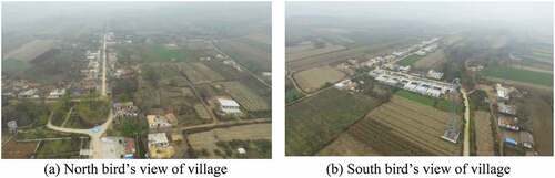
Figure 3. Present situation of Tao Qu Yuan Village. (a) North bird’s view of village. (b) South bird’s view of village.
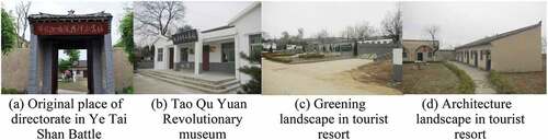
Tao Qu Yuan village is high in north and low in south, and the landscape is the typical gully region of the Loess Plateau. The village owns very good views with gully and rivers surrounding it. This village has the laudatory title of “revolutionary resort”, which is good for developing tourism industry. Three million has been invested for planning and rebuilding this area into a scenic spot, not only the old locust tree square, revolutionary museum, some sculptures were built and the original living rooms by the famous revolutionist, Deng Xiaoping, Xi Zhongxun and Yang Shangkun, also be rebuilt. What is more, observation deck, Ye Tai Shan Battle Museum, parking site and round mountain road and other infrastructure were also built, shown in .
Figure 4. Present situations on revolutionary tourist spot in Tao Qu Yuan village. (a) Original place of directorate in Ye Tai Shan Battle. (b) Tao Qu Yuan Revolutionary museum. (c) Greening landscape in tourist resort. (d) Architecture landscape in tourist resort.
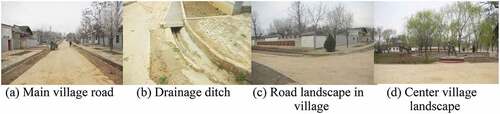
Most newly built houses are built on the original base. In order to fit the architectural style of tourist area, the facade is all redecorated. The main road owns good green belts and the drainage system is relatively good, .
Figure 5. Present situation of infrastructure in Tao Qu Yuan village. (a) Main village road. (b) Drainage ditch. (c) Road landscape in village. (d) Center village landscape.
3.3. Analysis of space distribution of ecological carrying capacity
3.3.1. Analysis of population developing scale in future
shows cultivable land carrying capacity in the current time and 2025, which are also shown in . Tao Qu Yuan village is a small-scale village with 168 families and 508 villagers. According to the cultivable land carrying capacity, 275 more people can be supported (Zhang et al. Citation2020, 3317).
Figure 6. Cultivable land carrying capacity of the villages in current time and 2025.
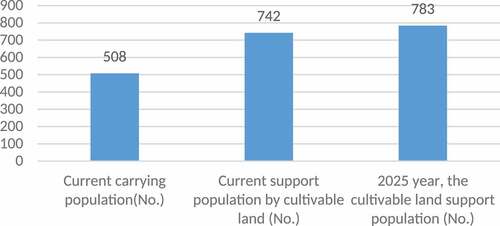
Table 3. Current cultivable land areas and the supporting population in research areas.
3.3.2. Division of suitable construction land by grid computing
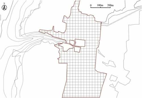
Before drawing the water and infrastructure distribution map, cultivable land, areas that cannot be used as construction place, and those suitable construction places, all should be figured out. According to “The management of construction land and basic cultivable land distribution map in Qin He town” and “Main planning map for different land usage in Qin He Town” in 2006–2022, combining with the site investigation, the construction place and the present village construction map can be drawn as , and the division of suitable construction land by grid computing is shown in .
Figure 7. Present construction situation and suitable construction land in Tao Qu Yuan village.
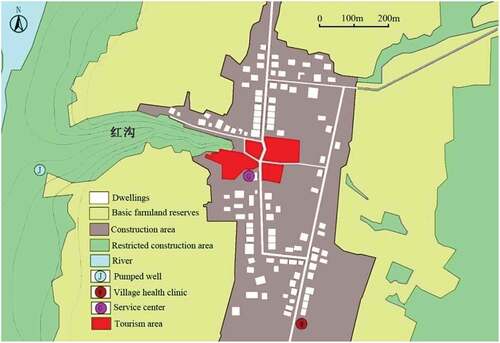
Figure 8. Division of suitable construction land.
3.3.3. Drawing the distribution map for water resource carrying capacity
Gully regions of the Loess Plateau are the most water-deficient areas in China. Most of the lands in the gully slope and tableland area are non-irrigated land, totally dependent on natural precipitation (Jun et al. Citation2010, 93–100). The natural resource development degree is considerably lower than the national bottom level, and the water supply from artificial wells is very limited, making it even more difficult to supply water for human living in some villages (Shi and Shao Citation2000, 9–20). Thus, in this area, analysis of the natural rain and underground water is not enough for the calculation of water resource carrying capacity.
The present water carrying capacity evaluation aims to check whether the existing water resources can meet the demand for the present population or an even larger population. The construction of artificial wells directly influences the amount of water supply.
Based on the site investigation of present water resource, we mainly focus on water supply infrastructure and the distance away from water resource (the distance has a direct relationship with future investment). Through field investigation of water resource, the water supply ability can be roughly graded as shown in .
Figure 9. Distribution map of water resource carrying capacity.
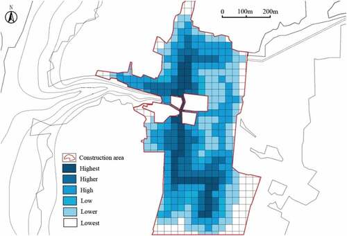
In this distribution map, the higher the water carrying capacity, the area color will be darker, which means the water supply facilities are better, the water pressure is higher and can support more population with less investment. The lower the water carrying capacity, the color of that area will be light, which means the water supply facilities are in shortage, and need much more investment to meet the water demand. In the future village planning, current water resource and the investment to improve are two important factors for planners to take into consideration.
3.3.4. Drawing the distribution map for infrastructure carrying capacity
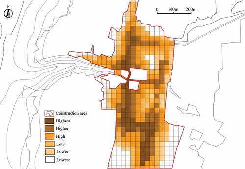
Rural infrastructure refers to the materials and technologies applied in rural production, living, and development, including economic infrastructure and social infrastructure, all of which are the developing conditions for rural economic and social development (Shenggen and Zhang Citation2004, 203–214). Infrastructure is the developmental basis for rural areas and also an important component in village planning, so it should be improved with the development of villages (Zhang Citation2007, 14–29).
When we do the infrastructure evaluation, the productivity, living style, ecological infrastructure and the distance between them, all of these should be researched. Through site investigation, the importance of each infrastructure to the area construction was investigated and the influence index was quantitatively evaluated. In the investigation on the infrastructure importance, six grades with the score from 0 to 5 are fixed, 936 pieces of questionnaire were distributed to the local residents, and 780 valid questionnaires were received. The total value for infrastructure importance is 100, and the results can show their influence index, .
Table 4. Statistics on the investigation of infrastructure importance and their influencing index.
Generally, infrastructures of transportation, electricity supply, small-scale industry and sanitary service have great influence. At present, there are no systematic evaluations for the ecological carrying capacity of infrastructure, in this case study, the infrastructure value can be obtained by multiplying the evaluation values of each infrastructure with their influence index, then these values are added together to get the comprehensive evaluation value. It can be divided into six grades according to the final evaluation values .
Figure 10. Distribution map of infrastructure carrying capacity.
3.3.5. Analysis of ecological carrying capacity distribution based on limiting factors
By field investigation, it is found that water resource and infrastructure own equally important position in village planning and the construction investment is almost the same, which can be proved by the 50% transparency of these two maps. Through the overlaying of water resource and infrastructure carrying capacity distribution maps in the suitable construction areas in Tao Qu Yuan village, the comprehensive ecological carrying capacity distribution map can be drawn .
Figure 11. Overlaying distribution map of water resource and infrastructure carrying capacity.
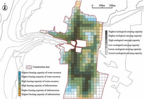
Combined with previous research, the overlaying distribution map of water resource and infrastructure is shown by different color lightness; the lower lightness means the ecological carrying capacity is higher. The color hue shows the main limitation factors for ecological carrying capacity. If the color tends to be blue it means the water resource carrying capacity is higher, and the infrastructure carrying capacity is lower. The color saturation can show the proportionality of ecological carrying capacity of this area, the lower the color saturation means the water resource and infrastructure carrying capacity is almost the same, the higher the saturation means there is great difference between them.
3.4. Suggestions on spatial planning of Tao Qu Yuan village
In order to guarantee the current residents’ living quality, the current ecological carrying capacity can support 275 people more. Village construction strategies should be made by the extension planning. Currently, the population has already near the threshold of current ecological carrying capacity, so it should improve the current ecological carrying capacity by the improvement of water resources and infrastructure, workforce and financial investment.
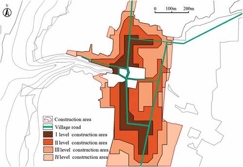
According to the overlaying distribution map, the suitable construction place can be roughly divided into four grades as shown in . Grade I area should be the priority developing place, and after this area comes to saturation, grade II area should be put into consideration, then grade III and IV.
Figure 12. Division of priority construction area in Tao Qu Yuan village.
If the extension area is small, the priority construction area can be fixed by the ecological carrying capacity distribution map. Based on the current water resource and infrastructure distribution map, the best extension method is to fully use current resource and avoid unnecessary investment.
If the extension is large, the current water and infrastructure facilities are hard to meet the demand of large numbers of new immigrants. Different from the small-scale extension, this kind of extension needs much more investments on current facilities. Areas with relatively high ecological carrying capacity can be chosen to improve the water facilities and other infrastructure to meet the requirement of village extension and guarantee human settlement quality. Thus, the distribution map of current resource is very necessary for classifying land where to construction and what degree to improve current facilities.
When large number of immigrants move in for once, certain areas should be selected to build more new water facilities and other infrastructure to meet the demand for productivity and living after the extension. For example, if 275 people (the limitation of new population growth) are immigrating for once, it means that 91 families will immigrate according to the average 3.02 people in one family in the current village. Such kind of immigration has already over two and half of the current family and large homestead is needed, it must have great influence on the current human settlement environment. There will be several problems for the original village. Firstly, the old and new buildings mix together make it in disorder, which is not only hard for keeping the original village characteristics, but also not good to improve the outlook of new countryside. Secondly, based on the original infrastructure, the large extension will make the water supply system hard to work normally even the overload work, all of these will decline human settlement environment.
In order to avoid these problems, area grading can be used as reference to save the social resource and make planning decision for future development. Centralized construction in the areas with high ecological carrying capacity not only saves resources, but also comes to be the public center for social activities and communication.
Fully use the local revolutionary tourism resource and build new countryside with special human settlement. At the same time, quality improvement of revolutionary tourism can also improve local residential living quality for its economic effects.
Finally, full use of the local revolutionary tourism resource and build new countryside with special human settlement, which can improve local residential living quality for its economic effects.
4. Discussion
Based on the ecological carrying capacity evaluation, drawing the overlaying distribution map on water resource and infrastructure can solve some current problems in village planning in gully regions of the Loess Plateau. Firstly, it can avoid unreasonable village combination and the unnecessary resource waste and construction investment. Secondly, it can avoid the common phenomenon of the same outlook of all villages caused by the lack of space distribution of villages’ ecological carrying capacity. Finally, through the analysis, the results can be used as a reference for the future construction and can solve the problem of backward infrastructure.
The current water resource and infrastructure are very complex, and there are no systematic indexes to calculate in an accurate way. The analysis in this paper is a combination of qualitative and quantitative research, its accuracy is insufficient. In order to better adopt the method in future village planning, a more complete, scientific evaluation system needs to be established to perform the symmetric quantity analysis. Besides this, this research field is still a gap in relative field, thus the analysis of ecological carrying capacity by limiting factors still has many shortages, which just do the rough evaluation on villages’ ecological carrying capacity and used as reference in villages human settlement planning within research areas. Thus, future research planning is shown as the following:
The infrastructure carrying capacity evaluation in this paper is a kind of qualitative research: the accuracy is not enough. In order to better adopt in the future village planning, it needs to establish a more complete, scientific evaluation system to do the symmetric quantity analysis.
Village planning based on the overlaying distribution map of limiting factors in ecological carrying capacity evaluation is just at the primary steps, and lack real case to prove this method. There must be some problems during the usage of this method in reality. It is hoped that this method can be improved and be perfect in some real village combination cases in gully regions in future.
The overlaying distribution map on limiting factors is mainly used in the process of village relocation and combination within small research areas, which is just a small part of new socialist countryside construction. It is hoped that this method also has its own important functions in the process of improving human settlement environment.
This research is actually supported by the National R&D Infrastructure and Facility Development Program of China and Science and technology research and development project of Shaanxi Province. During the field investigation and research object choice, local government took part in and gave lots of support. Although the spatial planning maps established by this research have not been realized by real village construction, the method of ecological carrying capacity analysis by limiting factors and the maps summarized by overlaying distribution maps supplied to local government as important reference for their village extension and combination planning. For improving local villagers’ living quality, this new method of village spatial planning can significantly reduce the unnecessary resource waste and construction investment. At the same time, the outlook of village can be adjusted according to the different ecological carrying capacity distribution, the living comfort can be improved.
5. Conclusion
The ecological environment in gully region of the Loess Plateau is fragile and its economic development falls behind the surrounding areas. Thus, it is very important to use the analysis of ecological carrying capacity to forecast and plan the future human settlement when the villages need to be combined. For the complexity and the suitability of the calculation of ecological carrying capacity, using limiting factors analysis may not be very accurate, but it can simplify the calculation process, and the results can be used as a rapid and efficient reference for the future human settlement environmental planning. This paper focuses on the gully regions of the Loess Plateau, basically using overlaying distribution map of limiting factors in ecological carrying capacity evaluation to do the research, and the results can be summarized into the following three parts:
Prove that limiting factor analysis has its feasibility and practicability in the analysis of ecological carrying capacity in gully regions of the Loess Plateau.
The limiting factors can be divided into two types. One is the unchangeable limiting factor, and the other is factors that can be improved according to its requirements. In this paper, three limiting factors are fixed: cultivable land, water resource and infrastructure. For the village combination, the cultivable land is used to fix the maximum immigration population. While the water resource and infrastructure are the two limiting factors in doing the spatial plan and fix the location for those new immigration population.
Through drawing the overlaying distribution map on limiting factors, the space distribution of ecological carrying capacity can be visualized. According to this distribution map, the suitability for construction and development can be divided into four grades, the area owns high ecological carrying capacity should be put in the priority developing position, which has significant influence on saving natural resource and social resource, and reduces the investment of constructing water infrastructure and other infrastructures. The areas with relatively low ecological carrying capacity can be used as construction areas following the priority areas. In this way, the village spatial planning in combination will be much more orderly.
Author contributions
Conceptualization, T.Z. and Q.H.; Data curation, T.Z., Q.H. and Y.L.; Formal analysis, T.Z.; Funding acquisition, D.Z.; Investigation, T.Z. and Q.H.; Methodology, T.Z. and Q.H.; Project administration, T.Z. and D.Z.; Resources, T.Z., Q.H. and D.Z.; Software, T.Z.; Supervision, D.Z., W.G. and H.F.; Writing – original draft, T.Z. and Q.H.; Writing – review & editing, T.Z. and Q.H. All authors have read and agreed to the published version of the manuscript.
Disclosure statement
No potential conflict of interest was reported by the authors.
Additional information
Funding
Notes on contributors
Tao Zhang
Tao Zhang was born in China in 1984. He got master degree in Xi’an Jiaotong University in 2011, and obtained the full scholarship from MEXT (Japanese ministry of Education, Culture, Sports, Science and Technology Scholarship) and got PhD in The University of Kitakyushu in 2016. Now he works in Innovation Institute for Sustainable Maritime Architecture Research and Technology, Qingdao University of Technology; also works in The University of Kitakyushu as special research fellow. His research is mainly about the Chinese rural planning, the architecture design in Chinese rural vitalization, ecological and sustainable development in rural areas. Since 2008, he took part in two national research projects on human settlement improvement in the Loess Plateau in China and has obtained large number of research results. During the study in Japan, he was mainly focus on the development history and the advanced design of Japanese vernacular dwellings. Currently, the combination of Japanese vernacular dwellings research and Chinese rural development is his research contents.
Qinian Hu
Qinian Hu is the member of Faculty of Environmental Engineering in The University of Kitakyushu. Her main research is about Japanese wooden house and Chinese rural environmental planning and construction. Through the research on the relationship between consumers’ attitudes, knowledge, housing purchase patterns, the Chinese timber frame houses developing situation, developing direction and methods have been research. Together with Tao Zhang, she also engaged in the research of traditional villages’ development in the Loess Plateau in China.
Dian Zhou
Dian Zhou is the dean and professor of the School of Human Settlements and Architecture Engineering in Xi’an Jiaotong University. His research is mainly on architectural design, living environment planning and design, ecosystem architecture design. He has co-edited a number of books, among them two are national architecture standard.
Weijun Gao
Weijun Gao is a professor in The University of Kitakyushu and professor in the Innovation Institute for Sustainable Maritime Architecture Research and Technology, Qingdao University of Technology. For a long time, he is engaged in urban energy planning, urban resource recycling and sustainable development, urban ecosystems and geographic information system, and he has obtained a large number of scientific research results. He has won the awards from the Architectural Society of Japan for twice. In 20001, he won the Design Award of the Architectural Society of Japan. As project leader, he has received 15 national scientific research grants and more than 20 other scientific research grants. In recent years, Professor Gao has focused on urban environment and building energy conservation, introduced urban environmental engineering into urban planning and architectural design, and solved environmental problems through interdisciplinary research.
Hiroatsu Fukuda
Hiroatsu Fukuda is a professor in The University of Kitakyushu and member of the Faculty of Environmental Engineering. He is also the chairman of the Japan Wood Ecological Recycling Research Committee, the chairman of the Environmental Design Operation Committee of the Architectural Society of Japan, the member of the Proceedings Committee of the Architectural Society of Japan, and the chairman of the Building Reuse Committee of the Asian Urban Architectural Society. His research is mainly about renewable buildings and wood utilization, environmental architectural design, and urban structural transformation methods in Japanese aging society. In the past five years, he published 4 papers in SCI international journals and Japanese architectural core journal, published more than 30 international conference papers.
References
- Ahnad, Y. J., and E. Lutz. 1989. “Environmental Accounting for Sustainable Development.” In The World Bank Symposium/The World Bank (Washington, D.C., USA), 118.
- APALi, D., C. Sun, and X. Zhang. 1998. “Modelling the Net Primary Productivity of the Natural Potential Vegetation in China.” Acta Botanica Sinica 40: 560–566.
- Cai, Y. L., F. U. Ze-Qiang, and E. F. Dai. 2002. “The Minimum Area per Capita of Cultivated Land and Its Implication for the Optimization of Land Resource Allocation.” Acta Geographica Sinica 57: 127–134.
- Cao, X. M., and R. Q. Zhou. 2008. “The Spatial Features and Leading Measures of Village System in Small Watershed in Loess Plateau Gully Region—a Case Study on Chunhua County Shaanxi Province.” Human Geography 5: 015.
- Cernea, M. M. 2003. “For A New Economics of Resettlement: A Sociological Critique of the Compensation Principle.” International Social Science Journal 55 (175): 37–45. doi:10.1111/1468-2451.5501004.
- Chen, B. M., and X. P. Zhou. 2007. “Explanation of Current Land Use Condition Classification for National Standard of the People’s Republic of China.” Journal of Natural Resources 22: 994–1003.
- Chun Hua County Annals. 2015. Local Chronicles Compilation Committee of Shanxi Province. Xian: Shanxi people’s Publishing House.
- Doxiadis, C. A. 1970. “Ekistics, the Science of Human Settlements.” Science 170 (3956): 393–404. doi:10.1126/science.170.3956.393.
- Ester, V. D. V. 2010. “Books: Our Ecological Footprint: Reducing Human Impact on the Earth.” Journal of Industrial Ecology 3: 185–187.
- Gao, L., and H. Y. Zhang. 2007. “Progress in Research of Ecological Carrying Capacity.” Chinese Journal of Population, Resources and Environment 17: 19–26.
- Gu, K. K. 2012. “Concepts and Assessment Methods of Ecological Carrying Capacity.” Ecology and Environmental Sciences 21: 389–396.
- Hu, W., C. C. Feng, and C. Chen. 2006. “The Study on System Optimization of Rural Human Settlements.” Urban Studies 6: 11–17.
- Jia, K. J., et al. 2020. “Spatial Optimization of National Land by ‘Double Evaluation’.” China Land Sciences 34 (5): 43–51.
- Jun, F., S. Mingan, W. Quanjiu, S. B. Jones, K. Reichardt, C. Xiangrong, and F. Xiaoli. 2010. “Toward Sustainable Soil and Water Resources Use in China’s Highly Erodible semi-arid Loess Plateau.” Geoderma 155 (1–2): 93–100. doi:10.1016/j.geoderma.2009.11.027.
- Li, Y., G. H. Zhao, and J. Zhou. 2011. “Establishment of Evaluation Index System of Ecological Carrying Capacity in Changping District Pusalu Village.” Procedia Environmental Sciences 11: 899–905. doi:10.1016/j.proenv.2011.12.138.
- Liao, H. X., Y. L. Ji, and S. L. Peng. 2016. “Resource and Environment Carrying Capacity and Sustainable Development.” Ecology and Environmental Sciences 25: 1253–1258.
- Liu, H., and L. D. Dong. 2006. “Mitigating Solutions under Environmental Pressure Urbanization Model of Typical Ecological Matrixes in Region of Human Loess Plateau.” Time+Architecture 4: 52–55.
- Liu, D., Z. Feng, Y. Yang, and Z. You. 2011. “Spatial Patterns of Ecological Carrying Capacity supply-demand Balance in China at County Level.” Journal of Geographical Sciences 21 (5): 833–844. doi:10.1007/s11442-011-0883-0.
- Liu, Y. Y., and D. Zhou. 2014. “Review on the Living Environment Planning Based on the Ecological Carrying Capacity Evaluation.” Huazhong Archit 3: 22–25.
- Liu, H. L., S. Pei-Ji, B. Yang, L. Hai-Meng, and W. Wei. 2015. “Hierarchical Scale Structure’s Evolution of Urban System Based on Ecological Carrying Capacity in Loess Plateau Region: A Case of Qing Yang City.” Arid Land Geography 38: 173–181.
- Liu, Y., J. Li, and Y. Yang. 2018. “Strategic Adjustment of Land Use Policy under the Economic Transformation.” Land Use Policy 74: 5–14. doi:10.1016/j.landusepol.2017.07.005.
- Long, H., J. Zou, J. Pykett, and Y. Li. 2011. “Analysis of Rural Transformation Development in China since the Turn of the New Millennium.” Applied Geography 31 (3): 1094–1105. doi:10.1016/j.apgeog.2011.02.006.
- Ma, Z. Y., Y. D. Xu, and J. J. Fan. 2003. “The Distribution Utilization and Sustainable Development of Water Resource in Shaanxi, China.” Northwestern Geology 36: 96–100.
- Mao, L., G. W. Li, and C. Z. Xu. 2010. “Study on Village Ecological Infrastructure.” Urbanism and Architecture 5: 120–122.
- Maos, J. O., and I. Prion. 1988. “The Spatial Organization of Rural Services: An Operational Model for Regional Development Planning.” Applied Geography 8 (1): 65–79. doi:10.1016/0143-6228(88)90006-9.
- Meier, R. L. 1978. “Urban Carrying Capacity and Steady State Considerations in Planning for the Mekong Valley Region.” Urban Ecology 3 (1): 1–27. doi:10.1016/0304-4009(78)90028-1.
- Morvaridi, B. 2004. “Resettlement, Rights to Development, and the Ilisu Dam, Turkey.” Development and Change 35 (4): 719–741. doi:10.1111/j.0012-155X.2004.00377.x.
- Schmidt–Soltau, K. 2003. “Conservation–related Resettlement in Central Africa: Environmental and Social Risks.” Development and Change 34.3 (3): 525–551. doi:10.1111/1467-7660.00317.
- Shaanxi Province Bureau of Statistics. 2014. Shaanxi Province City County Historical Statistical Data Compilation. Beijing, China: China Statistics Press.
- Shenggen, F. A. N., and X. Zhang. 2004. “Infrastructure and Regional Economic Development in Rural China.” China Economic Review 15 (2): 203–214. doi:10.1016/j.chieco.2004.03.001.
- Shi, H., and M. Shao. 2000. “Soil and Water Loss from the Loess Plateau in China.” Journal of Arid Environments 45 (1): 9–20. doi:10.1006/jare.1999.0618.
- Shi, N. H. 2001. History and Geography of the Loess Plateau. Henan Province, China: Yellow River Water Conservancy Press.
- Springer, J. 2009. “Addressing the Social Impacts of Conservation: Lessons from Experience and Future Directions.” Conservation and Society 7 (1): 26–29. doi:10.4103/0972-4923.54794.
- Tian, M. R., J. X. Gao, B. Zhang, and Q. Qiao. 2007. “Study on Assessment Index System of Ecological Community.” Research of Environmental Sciences 20 (3): 87–92.
- United Nations (UN). 1972 Report of the United Nations Conference on the Human Environment . The United Nations Conference on the Human Environment (The Stockholm Conference). Stockholm, Sweden, June 5–16. Accessed 15 October 2020. https://www.un.org/en/conferences/environment/stockholm1972
- United Nations (UN). 1976 United Nations Environment Programme Report . The United Nations Conference on Human Settlements (Habitat I). Vancouver, BC, Canada, 31 May–11 June. Accessed 15 October 2020. http://habitat1.org
- United Nations (UN). 1996 Pre-Conference UN Report and Preparatory Documents . The Second United Nations Conference on Human Settlements (Habitat II). Istanbul, Turkey, June 3–14. Accessed 15 October 2020. http://habitat2.org/
- United Nations (UN). 2016 Pre-Conference UN Reports and Preparatory Documents . The United Nations Conference on Housing and Sustainable Urban Development (Habitat III). Quito, Ecuador, October 17–20. Accessed 15 October 2020. https://habitat3.org/
- Wackernagel, M., L. Onisto, P. Bello, A. C. Linares, I. S. L. Falfán, J. M. García, A. I. S. Guerrero, and G. Mgs. 1999. “National Natural Capital Accounting with the Ecological Footprint Concept.” Ecological Economics 29 (3): 375–390. doi:10.1016/S0921-8009(98)90063-5.
- Wang, J., T. Sun, L. I. Peijun, and L. I. Fayun. 2005. “Research Progress on Environmental Carrying Capacity.” Chinese Journal of Applied Ecology 16: 768.
- Wang, Y. S., and D. Q. Zhang. 2010. “Study on the Ecological Construction of Towns in North Slope of Mount.” Qinlin in Xi’an: A Case of Zhouzhi Country. Huazhong Architecture 12: 126–130.
- Wei, W. Y. 2019. “Research on the Protection of Traditional Villages in Shaanxi Province.” Ph.D. Thesis, Northwest University.
- Xiong, Y., and Y. M. Li. 2010. “Application of State Space Method to Provincial Development Priority Zoning A Case Study of Human Province.” Journal of Ecology and Rural Environment 26: 109–113.
- Yu, H. X., R. Q. Zhou, and L. A. Liu. 2005. “Ecological Approach to Human Settlement Planning in Small Watershed Gully Areas on the Loess plateau—with the Example of Zaozigou Small Watershed in North Shaanxi.” Journal of Xian University of Architecture & Technology 2: 189–193.
- Yu, H. X., Q. Y. Guo, and X. B. Xie. 2006. “Construction of Coordinating Units in Urban System of Loess Plateau Gully Areas.” Journal of Architecture and Civil Engineering 23 (2): 76–80.
- Yu, H. X., and X. B. Xie. 2006. “Ecology Approach of Coordinating Development of Urban System of Loess Plateau Gully Areas.” Journal of Architecture and Civil Engineering 23 (4): 84–89.
- Yu, H. X. 2007. “A Study of Ecologic Theory and Plan-Designing Methods for Human Habitat in Gully Regions on Loess Plateau.” Ph.D. Thesis, Xi’an University of Architecture and Technology. 22:9.
- Yu, C. L., and R. Q. Zhou. 2008. “Research on the Suitable Evaluation Method of the Human Settlements Environment in Small Basin Based on Grid Data.” Huazhong Architecture 26 (1): 4–7.
- Zhang, T. Z. 1993. Outline of Loess Plateau. Beijing: Chinese Environmental and Scientific press.
- Zhang, X. S., and G. S. Zhou. 1995. “Exploration on the Model of Natural Vegetation as First Productivity.” Journal of Plant Ecology 19. 193–200 .
- Zhang, M. Y. 2007. “Research on the Relationship between Rural Infrastructure and New Socialist Rural Areas.” Hui Agricultural Science 12: 14–29.
- Zhang, T., B. Ding, Q. Hu, Y. Liu, D. Zhou, W. Gao, and H. Fukuda. 2020. “Research on Regional System Planning Method of Rural Habitat in Gully Regions of the Loess Plateau, under the Background of Rural Vitalization Strategy in China.” Sustainability 12 (8): 3317. doi:10.3390/su12083317.