
ABSTRACT
The value of the red heritage is usually reflected in the specific historical environment and the relevant narration among many heritages due to their joint participation in the historical. It is necessary to explore the model of heritage protection that organizes the scattered red heritage through historical events and integrates the whole area resources. The concept of ”red landscape” is proposed to integrate the red heritage and its historical environment. Taking the red landscape of Hong 'an as the research object, puts forward the steps of the spatial structure of the red landscape based on the historical narrative: Firstly, starting with the clue of “The campaign of Huang 'an”, a key historical event in the history of Hong 'an, we identify the red landscape related to the campaign to form a preliminary analysis framework. Then, three types of cultural resources were selected by analytic hierarchy process (AHP),forming a spatial structure with red landscape as the core and embedding of near-domain resources. The study shows that it is feasible to use historical events to comb red landscapes to obtain a spatial structure, which can be used as the basic framework for heritage protection, tourism development in the future.
1. Introduction
1.1. Background and significance of red landscape
In the history of modern China, the period from the beginning of the twentieth century to the founding of new China (1919–1949) is of great significance. During this period, people of insight in China were the first to awaken from the ancient feudal system. Relying on advanced ideas to unite and lead the Chinese people, they waged a hard and lasting struggle against the backward feudal system, aggression, and colonialism, and thus left a large number of historical relics, such as sites, buildings, and memorial sites, known as the “red heritage” (Jianping and Shuangqing Citation2008). Due to the characteristics of large number, wide distribution, and diverse types, “red heritage” occupies an important position in modern Chinese heritage.
In the past, limited by the concept of conservation, technical means, funds, and administrative authority, the key problems faced by local authorities in protecting the red heritage are as follows: the focus is on the preservation of the heritage itself and the restoration of details, while the historical environment around the heritage is not considered enough (Wang, Ma, and Wang Citation2020; Hao, Zhang, and Wang Citation2019), and the natural landscape, cultural customs, products, and historical resources of the heritage site are also ignored (Tan Citation2019). The consequences are while protecting the heritage of ontology of the strengthened, but the legacy of history environment was “constructive destruction,” for example, there is a lack of meaningful spatial connection between the heritages (most of them are just the connection of tourist roads), and the construction of the former site of the war headquarters, which should be relatively hidden and simple, is too exposed and magnificent, which destroys the real historical context (Yang and Zhao Citation2020; Jokilehto Citation2014; ICOMOS Citation1964, Citation2005). In order to solve this kind of problem, an integrated protection strategy becomes the inevitable choice of local government.
In practice, local governments have made a lot of useful explorations in integrating heritage protection practices with multiple departments, such as cultural relics, planning, and housing construction. However, it needs to be further clarified whether heritage relevance in the overall conservation strategy is meaningful enough rather than just “forced patchwork” and whether it will weaken valuable individuals by strengthening unique structures. Therefore, the overall protection of the value of red heritage should focus on a specific structural theme and be placed in an appropriate historical environment to be fully reflected. Based on this, this paper puts forward the concept of “red landscape,” which takes “red heritage” as the core carrier and integrates architecture, history, culture, ecological environment, historical environment, site spirit, and other contents, and is a comprehensive form of heritage” (Yong and Dahai Citation2019). It is of great practical significance to use “red landscape” to plan the overall protection of red heritage:, on the one hand, it provides evidence of authenticity for contemporary people like the red heritage, to prove that the current peaceful environment was achieved by the previous generation through suffering and struggle, so as to enhance the patriotic enthusiasm of the people and strengthen the national identity (Ryan Citation2011; Park Citation2010); on the other hand, those historical relics excluded from the “key protection list,” such as dilapidated battlefield ruins and harsh natural environment, truly reflect the fierce struggle environment in history and are more educational for contemporary people (Anna Irimiás Citation2014; Guo et al. Citation2017); Third, the use of red landscape for patriotism education can drive the use of other resources around, thus appropriately promoting the income of local governments and residents.
1.2. The historical narrative of red landscape
As a monumental heritage landscape, red landscape itself has more distinctive thematic, narrative (Xu, Zhang, and Wang Citation2020), educational, and regionality, the connotation of collective memory through the material and non-material cultural heritage generations, and get back in the new context of modern construction, in order to provide contemporary community the opportunity to experience the past memories, to strengthen and promote collective, national, and national identity. The red landscape is a complete system composed of buildings, roads, landscapes, and other spatial forms, so its semantic expression should take space as the carrier (Assman Citation2008). However, it is necessary to integrate the historical fragments behind the scattered spaces in order to give these spaces internal logic (Hautamäki Citation2020; Zhang and Xu Citation2019). The red landscape with historical narrative proposed in this paper is to associate the landscape elements including the red heritage and its surrounding environment with relevant historical events, emphasizing the dialogue between heritage and environment as well as the inherent relevance between heritage due to their joint participation in historical events. Therefore, a spatial optimization method with environmental basis and an appropriate way of telling history are very important for the inheritance of red history (Packer, Ballantyne, and Uzzell Citation2019). Through sorting out and refining the “relevance of historical fragments” and conducting intuitive structural integration in space, the relevance space with historical narrative sense is created.
Based on this, this paper tries to propose a method to integrate and relate red landscapes by using “historical narrative.” The goal is to form a basic framework for the protection and utilization of red landscapes. This spatial framework is composed of a number of heritage lines. The red landscape on the lines has a certain historical logic, and these heritages also integrate other resources within a certain range.
2. Case introduction: red landscape in Hong ‘an County
2.1. General situation of Hong ‘an County
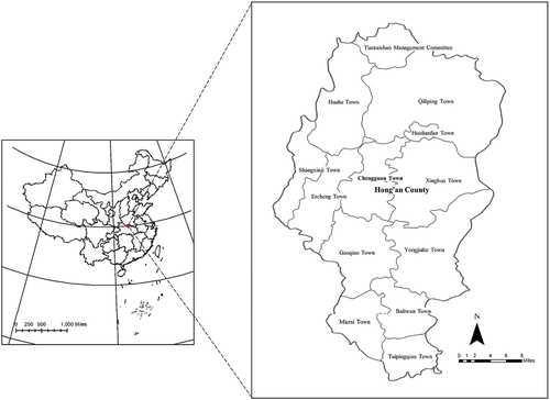
Located in the northeast of Hubei Province and in the south of the Dabie Mountains, Hong’an County (formerly Known as Huang‘an County) is between 114°23’-114°49‘EAST longitude and 30°56’-31°35” north latitude. It is at the junction of Hubei and Henan provinces and has a very important geographical location (). The total area of Hong‘an is about 1795 square kilometers, and the administrative areas include Chengguan Town, Qiliping Town, Huahe Town, Ercheng Town, Shangxinji Town, Gaoqiao Town, Miersi Town, Baliwan Town, Taipingqiao Town, Yongjiahe Town, Xinghua Town, Huolian-ban tea Field, Tiantai Mountain Management Committee, etc., totaling 12 towns and management committees and 396 villages. By the end of 2017, the county had 609,200 permanent residents.
Figure 1. The geographical location of Hong’an.
2.2. Red landscape and its distribution in Hong ‘an County
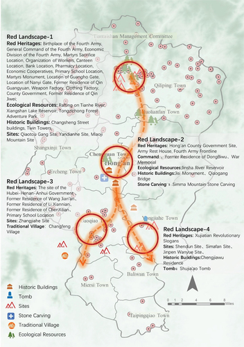
Hong’an based on this is a famous revolutionary area and the early political, economic, and cultural center of the Hubei-Henan-Anhui Base Area. Here were the birth of China’s famous “Red Army Fourth Front Army” and “28th Army,” Li Xiannian, Dong Biwu, two state presidents, and 223 founding generals, so it is known as the “Hometown of Generals.” Hong‘an County has a large number of red landscapes: a total of 218 red heritage sites are included in the list of Immovable Cultural Relics of Hong‘an County, including all levels of state, province, city, and county (). The main types are old site buildings and former residences of celebrities, as well as some tombs, battle sites, and stone carvings () (Dunxue and Bin et al. Citation2018). The local department in charge of cultural relics in Hong‘an has done a lot of effective work on the protection of the red landscape, including sorting out the historical information of the red heritage sites, regularly updating the status of conservation and maintenance, and tracking the use of conservation funds. Based on this, the most representative 42 red landscapes were investigated and interviewed for three times, and the important materials of red landscapes were basically mastered.
Figure 2. Distribution map of red landscapes in Hong’an County.
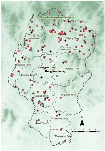
Figure 3. Typical red landscapes in Hong ‘an County.

2.3. Realistic problems of red landscapes in Hong ‘an County
2.3.1. The neglect of “secondary heritages” in the existing red heritage evaluation system leads to the rupture of the historical narrative chain
For a long time, the protection and utilization of red heritage has been considered as the natural responsibility of the cultural heritage department. Therefore, in the local governments represented by Hong ‘an, where the boundaries of financial power and administrative power are clearly divided, and under their respective jurisdictions, a set of heritage protection modes based on the criteria of “hierarchical evaluation and benefit priority” has been formed. That is, the red heritage with high visibility, low development cost, and high expected benefits should be selected as the priority level for protection, so as to achieve higher input return ratio, higher marginal benefits, and better economic and social benefits. This model did save a lot of valuable red heritage that was on the verge of destruction in the era of relatively underfunded and backward technology. But at the same time, one of the consequences is that the red heritage with low visibility and high protection costs (such as transportation costs and property rights recovery costs caused by remote locations) is increasingly ruined due to insufficient protection and attention, while the red heritage with high protection level generates surplus of funds. The red heritage in Hong‘an County is mostly distributed in the suburbs and villages, which is especially obvious ().
Figure 4. The relationship between the location, protection level and preservation status of red landscapes.
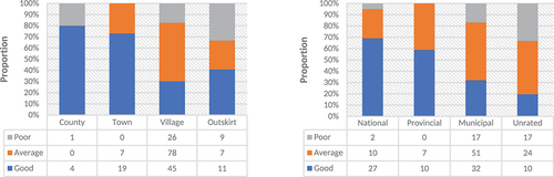
Red landscapes are produced in a unique geographical environment and historical background, and their spatial distribution reflects the strong characteristics of concealment and dispersion. Most of the time, it does not have the conditions of centralized protection. However, the value of the red landscape is often reflected in the group rather than the single, and there is usually a strong historical correlation between distant heritage points, which happens to be an important embodiment of the vitality of heritage (Stokes Citation2020). Therefore, the value of the red landscape must be fully presented in the overall narrative. Once a heritage is missing, the whole historical narrative chain will be destroyed. For example, the red heritage of “Clear Water Pond Meeting site of Hong‘an County” located in a remote mountainous area has low spatial accessibility and poor preservation status. However, this meeting is of great historical significance, so the site also has great protection value. Another example is the battlefield of some important battles, where there are no real structures left, and the form is only farmland, hillside, wasteland, and stone tablets, which is far from the identification standard of “red heritage,” but it is of great significance to understand the process of the whole campaign. The true course of historical events cannot be fully understood if such red landscapes are ignored.
2.3.2. The lack of environmental elements of red heritage results in the failure to make full use of near-domain resources
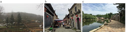
The natural environment and landscape form in red landscapes play a very important role in understanding the narrative of red heritage. It is mainly reflected in the following aspects: first, the characteristics of red heritage determine that it is particularly vulnerable to natural or man-made damage. The narrative of historical processes is vulnerable to rupture once irreversible damage has occurred, but its landscape form and natural texture generally will not change significantly. The conservation method based on “red landscape” can bring these environmental elements into the scope of protection and control to restore the historical context of red heritage as realistically as possible. For example, there are scattered battlefield sites and sacrificial sites of unknown martyrs in Places like Zhoujiachong, Hong‘an County. The war remains have been lost to human cultivation and construction activities, but when people see the mountains and rivers where the heroes fought, they can still appreciate the intensity of the campaign ().
Figure 5. (a) site of the Pooping Ridge Massacre in Zhoujiachong Village, Tiantai Mountain, (b) Changsheng Street revolutionary site community, Qiliping Town, (c) Zhujialou Village in Huajiahe Town.
Second, the value of the red landscape is usually complex and diverse. It not only has red cultural symbols during the war but also has a variety of values, such as architecture, history, and art. As a kind of local resource, these values can assist in strengthening the diversification of the utilization forms of the red heritage. For example, “Tiantai Mountain” in the north of Hong‘an County is a famous local scenic spot with excellent ecological resources. It is only 4.6 km away from the red heritage community in Qiliping Town in space, but there is no relevant utilization mechanism. As a result, the flow of people attracted by the red heritage cannot be smoothly introduced into the natural scenic spots to increase economic benefits, and the infrastructure and public service facilities of the natural scenic spots cannot be shared by the red heritage. The relative independence between the two is accompanied by the drawbacks of repeated investment and resource waste for local governments ().
Third, the coordinated conservation of red landscape and near-domain resources can complement each other. For example, “Doushan Village” and “Zhujialou Village” in Hong‘an County are scattered with a number of relatively low preservation levels of red heritage, but under the condition of relatively low investment, it has a good protection effect. The reason is that both villages are listed as “Chinese Traditional Village Protection List,” which not only protects the village landscape but also indirectly protects the overall environment of the red heritage ().
Therefore, it is urgent to break the development paradigm of “Benefit-First” and “Point-Protection” in the red landscape and pay more attention to the overall protection of environmental elements of the red landscape and the integrity of historical narration of the red landscape. With the progress of protection concepts and the improvement of the protection mechanism, integrity protection becomes the consensus and land department, planning department, hair change, natural resources, and many other functions, departments have joined red landscape protection, to explore both historical relevance, heritage sites, and near domain resources systematic overall value of new protection methods.
3. Methodology: analysis framework of red landscape based on historical narrative
3.1. The formation principle and construction process of red landscape system
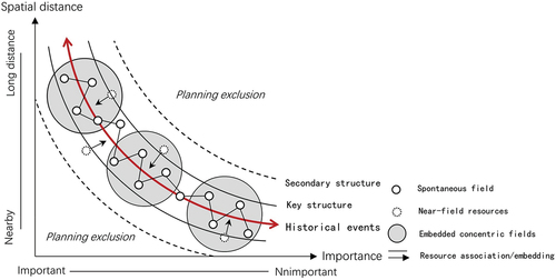
The red landscape is a landscape system composed of multiple elements and presented at multiple levels. First of all, the red landscape not only includes the red heritage in general meaning but also includes the compound value of the red heritage and the resource value of the surrounding environment, so it is a comprehensive space composed of multiple elements. Second, a large number of red landscapes are spatially related through the narrative logic of historical events, forming a structured and multi-level red landscape system in a larger scope. Based on this, this paper summarizes the construction process of red landscape system into three levels.
In the absence of intervention, the red heritage is scattered in towns or villages in points, and each heritage site (architecture, tombstone, ruins, and other types) and its surrounding historical environment, natural environment, and cultural environment together constitute a comprehensive heritage form, which is called “self-generated initial space” in this paper. This is the smallest level of the red landscape system, and the basic scale unit is usually the building or group of buildings. Then, through sorting out the revolutionary historical information of the sites of heritage, the key historical events are screened and extracted, and the heritage points represented by the events are spatially correlated according to the time series of historical events and the clues left, formed a large-scale spatial structure, which is called “narrative space correlation structure” in this paper. This is the second level of the red landscape system. Furthermore, centering on the representative red landscape, the paper sorts out and evaluates the near-area red heritage, natural resources, historical and cultural resources, selects and evaluates the heritage through its relevance to the historical narrative structure, and integrates it into the relevant structure to form an overall “spatial narrative structure of red landscape” ().
Figure 6. The spatial narrative structure of the red landscape system.
3.2. Steps of spatial combing based on historical events
The three construction processes of the red landscape narrative structure mentioned above are not formed spontaneously, and the red landscape usually presents a scattered distribution state in the state without intervention. However, if we want to integrate from “self-generated initial space” to “spatial narrative structure of red landscape,” we need to sort out the existing spatial distribution form of heritage. The spatial combing method of red landscape based on historical events can be divided into the following six steps ().
Table 1. Spatial combing method based on historical events.
This method of spatial integration is universally applicable to the spatial structure of red heritage. On the one hand, it ensures that the final spatial structure always follows the spatial sequence of the occurrence and development of key historical events; on the other hand, it integrates other related heritages and resources into the same structure as the basic framework of the red landscape. After the sixth step “path optimization” is completed in practice, the development process of historical events can be put into the spatial path for verification.
(1) Sorting out the historical context
The historical period of the location of the red heritage is divided, and the most important period is selected, which determines the unique position of this place in “the war situation of China at that time” and “the whole Chinese history.” The most intuitive basis for selection is the amount or level of red heritage left over from the period. Furthermore, it sorted out the important historical events that took place in the region during this period, and selected the most representative historical events as “key historical events.” The importance of historical events can be judged by the following criteria: they caused a turning point in the situation, represented the climax of the situation, determined the direction of the development of the situation, made a significant contribution, and were widely accepted by the public.
(2) Events extraction and association structure
According to the “key historical event” selected in the first step, the historical background and occurrence process of the event are deeply understood, and the red heritage points directly related to the event are selected from all existing heritage points. By taking advantage of the sequence of events and the spatial location of the heritage, time connection and space counterpoint are carried out in the current situation map to form the “narrative correlation space structure” of red landscape. This step provides an initial framework for spatial association.
(3) Construction of heritage evaluation model
Firstly, taking the red heritage related to key historical events as the center, a certain radius of space is set as the boundary of the red landscape, and the red heritage and surrounding resources within the boundary constitute the object of the evaluation of the red landscape. The radius of space range is not a fixed universal value but is dynamically adjusted in practice with terrain conditions, path accessibility, and the development level of traffic facilities. Second, the Analytic Hierarchy Process (AHP) is a classical quantitative research method that breaks down the influencing factors related to the goal layer by layer and provides a basis for the final decision by comparing the importance of various influencing factors layer by layer. The characteristics of multi-element and multi-level red landscape system determine the applicability of AHP in this study, so as to analyze and determine the impact factors of evaluation and build a multi-level weight evaluation system. Third, AHP is used to determine the weight value of each index, so as to build a multi-level heritage evaluation model.
(4) Factor evaluation and identification
First, the evaluation criteria for each impact factor were determined, and the elements within the scope of the red landscape were quantitatively scored and averaged. Secondly, the evaluation model of the third step is used to calculate the weight index of red landscape elements, so as to obtain the final score of each red landscape. Some heritage sites with the highest comprehensive scores were selected as the associated elements of the red landscape structure.
(5) Embedding of resources
Identify ecological resources, historical and cultural resources with unique value within the boundaries of the red landscape, and form the “spatial narrative structure of red landscape” together with the red heritage points identified in the fourth step.
(6) Path optimization
Based on the above evaluation results, the spatial route carrier, transportation infrastructure, street landscape environment, and important spatial nodes within and between the red landscape are systematically sorted and designed.
4. Construction of red landscape narrative space in Hong ‘an County
4.1. Sorting out the historical context of revolution
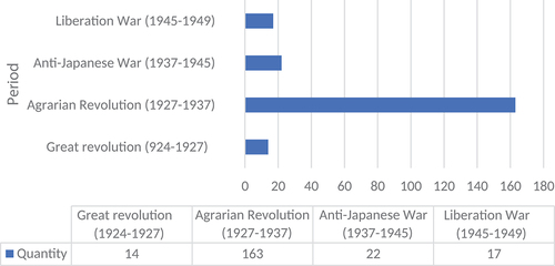
As the central city of the Hubei-Henan-Anhui Base Area, Hong‘an County has a large time span of its red heritage, covering the Great Revolution, Agrarian Revolution, War of Resistance against Japanese Aggression and War of Liberation. The number of red heritages left in each period is 14, 163, 22, and 17, respectively. The number of heritage points in the Agrarian Revolution period far exceeds that in other periods, indicating that the Agrarian Revolution has the deepest impact on Hong‘an County and can best reflect the overall heritage value of the region (). This paper combs the important revolutionary events in the history of Hong‘an, and selects the campaign of Huang ‘an, a representative campaign in the Agrarian Revolution period, as a key historical clue.
Figure 7. Red landscape quantity statistics in different periods in Hong‘an County.
The campaign was won by a few, disrupted the overall plan of the enemy “encircle and suppress,” had a very positive impact on the situation and promoted the Hubei-Henan-Anhui Base Area to reach the heyday of development. Huang‘an county was renamed “Hong‘an County” because of the victory in this campaign (Liming Citation2014). The military strategy adopted in the campaign has become an important innovation of modern military theory.
4.2. Events extraction and association structure
“The campaign of Huang “an” was one of the four famous campaigns launched by the Red Fourth Front Army in response to the third “encirclement and suppression” of the base areas by the Kuomintang after its establishment. It was also the first campaign after our army was reorganized and ended in victory. Xu Qianqian, general commander of the Red Fourth Front Army, and Chen Changhao, political commissar, adopted the strategy of “besiege the city and attack reinforcements.” The task was divided into three steps: the first step is to attack the enemy stronghold outside the city of Huang‘an and cut off the connection between the city and the outside. The second step is to intensify the siege of Huang‘an city and attack the enemy forces that may reinforce it; The third step is to take down the garrison of Huang’an County.
“The campaign of Huang “an” lasted 43 days and was launched from the establishment of the Red Fourth Front Army in Qiliping Town in the north. The main operational routes were Qiliping – East Wangjia – County – Xiaxu – Dazhao Jia, Gaoqiao Town, and Cattle mountain. The campaign is shown in .
Figure 8. Three stages of the campaign of Huang‘an: November 1931, December 1931 and December 1931.
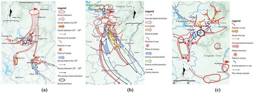
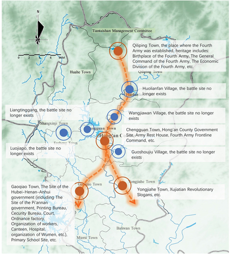
Due to the randomness of the site selection of battlefield and headquarters during the war, and the marching of troops does not always follow the determined route, the distribution of red landscape is relatively scattered, which leads to the fact that there is no protection and development system with “The campaign of Huang “an” as the theme in Hong‘an County. The first step of the study was to sort out all the red heritage sites in the county, screen out the heritage sites related to “The campaign of Huang‘an,” and match the time and content of these eight heritage sites on the current status map. The historical sequence, campaign sites, the location of military strategy sites, and relevant people and their activities were studied, so as to draw a rough marching route as the main associated structure of the red landscape ().
Figure 9. Narrative structure of directly related points in the campaign of Huang ‘an.
4.3. Construct heritage evaluation model
Red landscape narrative system based on historical narratives needs to organize the space with historical events, so certain conditions need to be set to screen the red heritage and related resources. In order to avoid the subjectivity of selection, we need to introduce a quantitative method of hierarchical analysis to construct the evaluation standard model. In order to avoid all the elements involved in evaluation, which can lead to unnecessary workload, the research firstly defined the evaluation of the object:
Centering on the heritage points directly related to the Campaign screened in the previous step, the boundary of the red landscape is delimited with reference to the distance standard mentioned in the “15-min living circle” planning (around the residential community, 15-min walking distance (about 1–2 km) is taken as the service radius of supporting urban public facilities). The realistic possibility of an association between red heritage within the scope is guaranteed. As the object of heritage evaluation, the red heritage points within the boundary not only ensure the larger coverage of the red landscape but also avoid the reduction of the accessibility of the red heritage space caused by the distance too far.
According to the AHP, the influencing factors of the evaluation model should be determined first, that is, what types of resource elements should be selected and how strong the association between heritages is to be included in the red landscape system. The narrative construction of red landscape needs to pay attention to the two main characteristics, namely “Diversity” and “Relevance,” and applies them to the analysis of the influencing factors of heritage evaluation. The corresponding two basic thinking points are “Landscape Richness” and “Landscape Correlation.” The former includes “Heritage Value” and “Heritage Resource Value,” and the latter includes “Landscape Element Density” and “Landscape Element Accessibility”.
The historical information, current preservation degree, heritage type, and value diversity of the red heritage within the scope are sorted out as the impact factors of “Heritage Ontological Value.” The ecological value, historical and cultural value, and intangible cultural heritage of the sites of heritage are sorted out as the impact factors of “Heritage Resource Value.” The above two forms the evaluation basis of “Landscape Richness.” The density of red landscape elements was evaluated according to the intensity of the red heritage and the distance between the heritage and resources. The accessibility of red landscape elements is evaluated according to their location conditions and road conditions, which together constitute the evaluation basis of landscape correlation degree.
The above evaluation contents constitute a three-level evaluation system (). It should be noted that the evaluation system should be open and dynamic. The content of impact factors may increase or decrease with the change of evaluation objects and evaluation purposes, but in general, the change of non-important impact factors will not have a subversive effect on the final results.
Table 2. Three-tier evaluation system.
Experts in the field of heritage protection are invited to form an expert committee. After comprehensive discussion and comparison, the importance of impact factors at each level is compared to build a comparison matrix of evaluation factors. Generally, the higher the abundance of elements per unit area, the stronger the potential correlation. In the red landscape evaluation system, the richness weight of heritage elements should be higher than the correlation degree of heritage elements so the weight score of the impact factors of the first level is obtained in the table ().
Table 3. The importance comparison matrix of the first-level evaluation factors.
In the second level, the value obtained by the red heritage due to its participation in historical events and revolutionary war should be in the first place, and the weight of its influence factor is higher than the compound value of other aspects of the heritage, which is determined by the theme of the protection of the red heritage. The more dense the red heritage distribution, the more accessible it will be within walking distance. Therefore, the density of the heritage should be given a higher weight in landscape correlation ().
Table 4. The importance comparison matrix of the second-tier evaluation factors.
At the third level, the weight of the four influencing factors of heritage historical information, preservation degree, value richness, and type diversity are compared, respectively, and it is believed that in the landscape system constituted by key historical events, the importance of historical information carried by heritage should be given a higher weight. Among the factors of resource diversity, the contribution of green ecological value and historical and cultural value to landscape richness is higher than that of intangible cultural heritage. The intensity factor of heritage and the importance of distance between heritage and other resources should give way to the intensity of red heritage. Among landscape accessibility factors, location conditions have a higher impact on the accessibility of red heritage than route patency, because more modes of transportation can be selected as long as the attractiveness of red heritage is large enough ().
Table 5. The importance comparison matrix of the third-tier evaluation factors.
In order to calculate the weight score of each red heritage point in a more detailed way, the weight score of the third-layer evaluation factor is listed separately ().
Table 6. Summary of the calculation of the weights of the third-level evaluation factors.
4.4. Factor evaluation and identification
The fourth step is to score the red heritage and near-domain resources according to the above evaluation model. The rating system is made up of 100 points, and experts in urban planning and heritage protection are invited to evaluate the value of the red landscape. In order to avoid the confusion caused by too many evaluation factors, the influence degree of impact factors is comprehensively reflected in four score segments: 80–100, 60–80, 40–60, and below 40. According to the final weight value of each impact factor in , the value score of the red heritage is weighted (the calculation process is omitted), and then the final value score of each red heritage is obtained (). According to the ranking of the evaluation score, different protection levels can be further divided, and classified discussion can be carried out according to the characteristics and values of the red heritage of different levels, which can make the protection measures more targeted.
Table 7. Red landscape and resource value evaluation scale.
Under the restriction of the space capacity of the red landscape structure, the red heritage with higher evaluation grade can be included into the overall structure of the red landscape. Of course, some low-rated red heritage sites do not mean that they lack conservation value in themselves, because the evaluation model is based on the value criteria of specific historical events, which has been fully considered in the weight development of impact factors and expert ratings.
4.5. Embedding of resources
According to the above calculation, the red landscape is sorted according to the score from high to low, and different protection and utilization strategies can be adopted for different score ranges. In the red landscape structure based on historical narrative logic, priority should be given to the red heritage with a high score embedded in the relational structure as the embodiment of the comprehensive value of the red landscape.
Red heritage points with more than 70 points should be selected as the final red heritage points to be associated with, together with the 8 heritage points directly related to key historical events in the second step; In addition, other green ecological resources and historical and cultural resources with unique values are distributed within the boundary of the red landscape, which together with the identified red heritage form the “spatial narrative structure of red landscape” and are embedded in the associated structure of the red landscape ().
Figure 10. Spatial narrative structure of red landscape in Hong ‘an County.
4.6. Path optimization
Based on the above evaluation results, the spatial route carriers, transportation infrastructure, street landscape environment, and important spatial nodes within and between the red landscape are systematically sorted and designed to form a red landscape narrative structure with smooth plane closure, clear hierarchy, and clear narrative logic.
5. Conclusion
Based on the clue of “key historical events,” this paper analyzes the multi-dimensional landscape elements and their interaction with the red heritage in Hong‘an County, Hubei Province. The main conclusions are as follows:
First, the historical background and current characteristics of the red landscape determine that its value needs to be presented in the overall structure, including the overall structure between the red heritage and the surrounding natural environment, the overall structure between the red heritage, and the overall structure between the red heritage and other resources. Therefore, the traditional mode of “Point-Protection” needs to be broken through, and the historical narrative of heritage space needs to be realized through the effective spatial association of red landscape and its environment.
Second, the steps of spatial sorting based on historical narrative are proposed: firstly, starting with the clue of the campaign of Huang‘an, a key historical event in the war history of Hong‘an County, the red landscape directly related to the campaign is identified and extracted to form a preliminary analysis framework in space. Then, with these landscape points as the center, an evaluation model is constructed to select the red heritage indirectly related to the campaign and other important heritage to be included in the analysis framework. Furthermore, other historical and ecological landscape resources in the red landscape are incorporated into the framework, thus forming a holistic narrative spatial structure framework with the red landscape as the main content, key historical events as the relevant clues, and integrating into the important resources in the near domain.
Third, a set of scoring standard systems based on three levels of impact factors is proposed to evaluate the importance of red landscape in grades, avoiding the subjectivity of artificial evaluation to the greatest extent, so as to screen out several targets most associated with key historical events from numerous red heritages.
Fourthly, based on the above spatial sorting steps, the red landscape of Hong ‘an is sorted out in space, and a “spatial narrative structure of red landscape” based on “The campaign of Huang “an” is finally established. Through this narrative space structure, the exhibition of revolutionary history education can enhance the spatial continuity and historical narrative of the red heritage, and make it more interesting and vivid. In the tourism development of local government, narrative space structure can also be used as a reference for tourism route selection. In the protection planning of revolutionary heritage, narrative space structure can be used as a reference for route selection of historical landscape corridors. In this way, the scattered red landscape can be spatially associated by providing specific narrative logic as the basis for the formulation of different conservation strategies.
Disclosure statement
No potential conflict of interest was reported by the author(s).
Additional information
Funding
References
- Anna Irimiás. 2014. ”The Great War Heritage Site Management in Trentino, Northern Italy.” 9 (4): 317–331. doi:10.1080/1743873X.2014.908886
- Assman, A. 2008. “Transformations Between History and Memory.” Social Research: An International Quarterly 75 (1): 49–72. doi:10.1353/sor.2008.0038.
- Dunxue, C., D. Bin, et al. 2018. Red Mark – Revolutionary Relics and Memorial Buildings in Hong ‘An County [M]. Beijing: China Cultural and History Press, August
- Guo, X., L. Yao, Z. Li, and X. Guo. 2017. “The Evolution and Development Trend of the War Heritage Presentation.” Journal of Western Human Settlements Environment 32 (2): 57–62. doi:10.13791/j.cnki.hsfwest.20170210.
- Hao, H. Z., W. K. Zhang, and J. Wang. 2019. “Research on the Combination Mode and Protection and Utilization of the Red Cultural Heritage Community—taking Northern Shaanxi as an Example.” City Building 16 (22): 31–38.
- Hautamäki, L. 2020. “Heritage of the Finnish Civil War Monuments in Tampere.” Landscape Research 45 (6): 742–757. doi:10.1080/01426397.2020.1749580.
- ICOMOS. 1964. “Venice Charter: International Charter for the Conservation and Restoration of Monuments and Sites. In Second International Congress of Architects and Technicians of Historic Monuments.” Accessed 24 April 2018. https://www.icomos.org/charters/venice_e.pdf
- ICOMOS. 2005. “Xi’an Declaration on the Conservation of the Setting of Heritage Structures, Sites and Areas.” Adopted in Xi’an, China by the 15th General Assembly of ICOMOS on 21 October 2005. Final version - 22.10.2005.
- Jianping, L., and L. Shuangqing. 2008. “New Construction in Rural Areas the Legal Protection of the Cultural Heritage of the Red Economic Analysis [J].” Economic Geography 28 (6): 1049–1052. doi:10.15957/j.cnki.jjdl.2008.06.030.
- Jokilehto, J. 2014. “What is Modern Conservation? –Some Thoughts About the Evolution of Modern Conservation Policies.” Journal of Western Human Settlements Environment 29 (1): 16–20. doi:10.13791/j.cnki.hsfwest.2014.01.004.
- Liming, M., ed. 2014. Starting a Fire: An Overview of the Revolutionary Base Areas in China [M]. China Development Press, March (revised 2015 March).
- Packer, J., R. Ballantyne, and D. Uzzell. 2019. “Interpreting War Heritage: Impacts of Anzac Museum and Battlefield Visits on Australians’ Understanding of National Identity.” Annals of Tourism Research 76: 105–116. doi:10.1016/j.annals.2019.03.012.
- Park, H. 2010. ”Heritage Tourism: Emotional Journeys into Nationhood.” Annals of Tourism Research 37 (1): 116–135. ( 2008).
- Ryan, C. 2011. “Battlefield Tourism: History, Place and Interpretation [M]. Oxford: Elsevier, 2007; R. Dunkley, N. Morgan, S. Westwood. Visiting the Trenches: Exploring Meanings and Motivations in Battlefield Tourism [J].” Tourism Management 32: 860–868.
- Stokes, A. 2020. “War Tourism: Second World War France from Defeat and Occupation to the Creation of Heritage.” European Review of History: Revue Europeenne d’histoire 27 (4): 573–575. doi:10.1080/13507486.2020.1715043.
- Tan, L. D. 2019. Research on Display and Utilization of Qiliping Revolutionary Site in Hong’an. Huazhong University of Science and Technology.
- Wang, X. D., J. X. Ma, and B. Wang. 2020. “Investigation and Protection of the Old Revolutionary Buildings in Huatuo Village.” Architecture and Culture 5: 259–260.
- Xu, Y. F., W. K. Zhang, and J. Wang. 2020. “Research on the Protection and Utilization of the Old Revolutionary Buildings——A Case Study of the Old Site of the Underground Liaison Station of the CPC in Qingdao.” Art and Design 2 (7): 75–77.
- Yang, Y., and Y. Zhao. 2020. “A Study on the Overall Protection and Utilization of Decentralized Revolutionary Sites from the Perspective of Symbiosis Theory: Taking the Sites of the Jinchaji Border Region Government and Military Command as an Example.” Journal of Baoding University 33 (4): 122–129.
- Yong, Z., and X. Dahai. 2019. ”Creative Design Strategy of Red Landscape Planning from the Perspective of “Field” – a Case Study of Yimeng Red Landscape[j].” Shandong Social Sciences, no. 1: 127–133. doi:10.14112/j.cnki.37-1053/c.2019.01.021.
- Zhang, Y., and D. H. Xu. 2019. “The Creative Design Strategy of Red Landscape Planning from the Perspective of “Field”—taking Yimeng Red Landscape as an Example.” Shandong Social Sciences 1: 127–133. doi:10.14112/j.cnki.37-1053/c.2019.01.021.