
 ?Mathematical formulae have been encoded as MathML and are displayed in this HTML version using MathJax in order to improve their display. Uncheck the box to turn MathJax off. This feature requires Javascript. Click on a formula to zoom.
ABSTRACT
The dynamic change in land use can reflect the change in the ecological environment and social economy. Zhangjiajie is the famous mountain tourist city in China having a dual core central structure constituting the urban central area and Wulingyuan Scenic Area (referred to as DCC). This study is based on the land use data of Zhangjiajie in 2000, 2010, and 2020. It analyzed the dynamic change in the pattern of land use, its cause and effects using the method of human-computer interaction for remote sensing image interpretation. The study revealed: (1) the growth of construction land is the maximum, while cultivated land and grassland are mostly transformed into construction and forest land. (2) The reasons why Zhangjiajie with limited cultivated, and idle industrial land was mainly transformed into tourism construction land, especially the townships around DCC. (3) The development of townships around DCC should build industrial belts for coordinated development. This study attempts to analyze the development dilemma and outlet of Zhangjiajie’s DCC on its surrounding 12 townships using the results of land use change aiming to realize the integrated development of DCC and township area, to provide practical experience for green development of township industry around mega-tourist attraction.
GRAPHICAL ABSTRACT
1. Introduction
Land use is a long-term or cyclical operation of land by humans, and it has certain economic and social purposes (Shi et al. Citation2000; Ju et al. Citation2020). Land use change is the closest interaction between nature and humans (Zhang, Zhao, and Wang Citation2012) and can reflect ecological and socio-economic changes (Deng et al. Citation2009; Dang et al. Citation2021; Fetai, Grigillo, and Lisec Citation2022; Iacopino et al. Citation2022). As one of the important industries in urban and rural, the study of the relationship between tourism and land use has received early attention from academics and has gradually intensified (Ma and Jin Citation2014). In 1930, McMurry first raised the issue of the relationship between tourism and land use in “The use of land for recreation” (McMurry Citation1930). Subsequently, scholars from different countries have conducted a series of studies on land use/cover change (LUCC), space development and utilization patterns in tourist cities, and have proposed various types of land use models for recreational activities and tourist resorts (Hu and Lu Citation2009; Greer and Wall Citation1979; Hammes Citation1994; Liu et al. Citation2014; Xie, Chandra, and Gu Citation2013; Xi et al. Citation2016). In particular, land use models that focus on tourism and recreation functions (Gunn Citation1988; Weaner Citation1993) have had a profound impact on studies related to tourism and land use in Chinese tourism academia. Chen (Citation2010), Wang and Liu (Citation2009), Wu (Citation2001), Yang Jun et al. (Citation2014), Ma and Jin (Citation2014), Wu et al. (Citation2015), Xi, Wang, and Kong et al. (Citation2016), Zhu, Xie, Xiong (Citation2017), and Dong et al. (Citation2021) studied the relationship between land use change and tourism development at different spatial scales, such as Jiangsu Province, Sanya City, Zhangjiajie City, Dalian City, Yangshuo County, and Zhouzhuang Town. They found that land use changes were driven by tourism development in the region, including rapid expansion of land for tourism construction, rapid restructuring of agriculture, reduction of arable land resources, and abrupt growth and decentralized layout of construction land area.
Zhangjiajie is located in the hinterland of Wuling Mountains, and is the core of the ecological and cultural tourism circle in western Hunan. It is the main tourist distribution center in Hunan Province and the border areas of Hunan, Hubei, Chongqing, and Guizhou. It is also one of the most typical mountain tourism cities in China (Hunan Provincial People’s Government Citation2012). Zhangjiajie has a history of more than 2000 years. It was earlier called “Dayong.” In 1988, Wulingyuan Scenic Area was listed as a national tourist attraction, and the tourism industry developed rapidly. The development of tourism in Zhangjiajie can be divided into three stages:
(1) The 1990s-2010 was the construction of tourist attraction stage. In 1994, “Dayong” was renamed Zhangjiajie; in 1996, the municipal government proposed the “tourism-driven strategy,” and the first tourist train in Hunan Province, “No. Zhangjiajie (Zhangjiajie to Guangzhou 26/25)” was launched. In 1998, Zhangjiajie was awarded China’s excellent tourism city and the city’s civilized tourist attraction. In 2007, Wulingyuan Scenic Area was selected as the first AAAAA tourist attractions in China. Zhangjiajie has become a famous mountain tourist city in China.
(2) 2011–2015 was the stage of accelerated urban construction and urban tourism. The Hehua Airport was upgraded to an international airport in 2011, making Zhangjiajie an important air gateway in northwest Hunan. In 2012, the urbanization rate increased from 37.2% to 41.1%, and the built-up area of the city expanded by one-thirds. In 2013, Zhangjiajie was honored as the national pilot city of comprehensive tourism reform, the most influential city in China overseas, a member city of World Tourism Cities Federation, a world observatory of sustainable tourism development, and the national model city of “double support.” In 2015, Zhangjiajie became a pilot city for new urbanization in Hunan Province.
(3) In 2016, Zhangjiajie began to explore the trinity strategy of synergistic development of the city, tourist attraction, and countryside driven by the twin wheels of the city and tourist attraction in the context of ecological civilization. By 2019, Zhangjiajie had received 79.123 million domestic tourists, 1.37 million inbound tourists and total tourism revenue of 90.56 billion yuan (Zhangjiajie Municipal People’s government, Citation2020). In 2020, owing to COVID-19, the number of visitors in Zhangjiajie declined sharply. However, with the gradual relaxation of the COVID-19 travel restrictions, Zhangjiajie’s tourism industry will recover. At this stage, Zhangjiajie’s urban built-up area is expanding, and the city and tourism development are facing new opportunities while also encountering old problems, highlighting different degrees of restrictions. Poverty and weak development of the majority of township areas are responsible for the vigorous development of Zhangjiajie and tourist attractions and the expansion of land use. The vast township areas are the development hinterland of Zhangjiajie’s DCC which also contribute toward poverty alleviation and rural revitalization in Zhangjiajie. They are the basis for the coordinated development of the central urban area, Cili County, and Sangzhi County. Against the background of building a moderately prosperous society, benchmarking and improving the quality of tourism, based on the goal of Zhangjiajie to build a world-class tourist destination, a national ecological civilization construction demonstration area, a national special type of regional revitalization demonstration area and Wuling Mountain area as new highlands of reform and opening up (Zhangjiajie Municipal People’s government Citation2021), is important. It is particularly necessary for the overall quality improvement, upgrade and development of various districts, counties, and towns in their various aspects such as industry, space, and facility construction.
The purpose of analyzing land use change is to discover potential and meaningful regularities from the seemingly disordered distribution of land use elements and to determine the mechanisms that generate and control spatial patterns (Chen et al. Citation2008), in order to further analyze the development and evolution process of three kinds of spaces: urban, tourist attractions, and rural, which is conducive to optimizing the spatial patterns of mega-tourist attractions and their surrounding urban and rural areas and improving land use efficiency. It is also of practical significance to deepen the land use/cover change (LUCC) theoretical system to guide the development of tourism cities and industries. Cities and tourist attractions are highly populated areas, especially a typical tourist city such as Zhangjiajie, which has a super large tourist attraction that receives tens of millions of tourists every year. Almost all kinds of land use changes can find the direct or indirect impact of tourism (Zhang Citation2007). The huge demand for construction land in cities and tourist attractions has generated the push force of the rapid expansion of urban construction land and tourism facility land to its surrounding townships, which indicates the transformation of township agricultural and natural landscape land to urban and tourist attraction construction land to a certain extent (Chen Citation2010; Wang and Liu Citation2009; Tan et al. Citation2014; Bai, Shi, and Pan Citation2022). Therefore, the authors try to analyze the spatial crowding effect of Zhangjiajie’s DCC on its surrounding townships, in order to discuss the development dilemma and way out of townships, and realize the integrated development of the central city – mega-tourist attraction – township area. The aim is to provide practical experience and reference for the green development of the industry in the townships around the mega-tourist attraction, and to provide new ideas for the planning of this type of township system.
2. Methodology
2.1. Study area
Zhangjiajie is located in the hinterland of Wuling mountain area in the northwest of Hunan Province. The terrain is mainly hilly and mountainous, with complex geographical structures and karst landform. The climate type of the city is subtropical monsoon humid climate, with an annual average temperature of 17°C. The urban area of Zhangjiajie includes two districts and two counties, seven sub-districts, 32 towns, 47 villages, and 15 ethnic villages, with a total area of 9533.87 km2. Since 2000, in response to the national policy of western development, the construction of new urbanization in Zhangjiajie has developed rapidly. In 2020, the urbanization rate had reached 50.5%, and the land use pattern had changed significantly.
2.2. Theoretical basis
2.2.1. (1) LUCC
LUCC refers to Land Use/Cover Change, which objectively records the transformation process of the earth’s surface layer by human activities and reproduces the spatial and temporal dynamics of the earth’s surface landscape, and is an effective way to reveal the mechanism of interaction between human activities and the natural environment (Global Land Project (GLP) Citation2005; He et al. Citation2021). LUCC research has been conducted for over 30 years since the 1990s, and scholars from different countries have built a large number of LUCC research models in different fields based on different perspectives and spatial scales. The strategies proposed by these studies on territorial and industrial development, and climate adaptation are strategically important for the sustainable development of resources, environment, and socioeconomics (Herrick et al. Citation2013; Jin et al. Citation2013; J. Y. Liu, Citation1996; Liu et al. Citation2010; Kuang et al. Citation2013). In the tourism academic community, scholars generally agree that tourism development is a driving factor for LUCC (Zuo Citation2005). Particularly since the late 20th century, owing to China’s rapid urbanization and industrialization, tourism as an industrial form needs to be subordinated to the overall arrangement of urban and rural land use. However, as a driving factor of urban and rural development, tourism will also influence land use. Therefore, the relationship between LUCC and tourism development is a two-way interaction (Ma and Jin Citation2014).
2.2.2. (2) Industry clusters and industrial belts
“Clustering” and “agglomeration development” are inevitable laws for many industries (C. K. Liu, Citation1996; Marshall Citation1965), and they bring “1 + 1 > 2” benefits of agglomeration. The formation of tourism industry clusters or industrial zones is a spatial and territorial agglomeration of tourism, associated, and auxiliary enterprises and related institutions, around advantageous tourism resources or tourism destinations with superior location conditions (Xu Citation2013), which is a phenomenon and a way of development. The phenomenon of evident tourism industry clusters in areas with developed tourism and a long history of tourism development are conducive to the sustainable development of tourism destinations and the sustained growth of the tourism economy (Braun Citation2005). From another perspective, tourism industry clusters are a regional tourism development strategy that can promote regional tourism cohesion and the harmonious coexistence of inter-regional tourism industries.
2.2.3. (3) Symbiosis theory
The concept of symbiosis was first introduced by the German mycologist Anton de Bary in 1879 (Anton de Bary Citation1879). Over the past 100 years, the symbiosis phenomenon and theoretical research have gradually penetrated and extended from the field of biology to many fields of sociology and management, and have made significant progress and development (Yuan Citation1998). Tourism as a highly relevant and comprehensive industry involves traditional primary, secondary, and tertiary industry sectors. It is one of the focus points of urban-rural industrial symbiosis, mainly in the exchange and sharing between urban and rural areas of industry factors such as land, market, labor, capital, information, and technology. In the process of exchange and sharing between urban and rural tourism industries, the development of tourism products, the exchange of visitor sources, and the flow of talents and capital provide the possibility of symbiosis between them. Simultaneously, the existence of land differential rent has led to the emergence of the recreational belt around the Metropolis (Wu Citation2001). The symbiotic development of urban and rural tourism industry is conducive to their integration and industrial transfer. It enables the countryside to absorb the spillover influence of urban tourism, thus revitalizing idle land in the countryside, strengthening infrastructure construction, improving cultural industry investment, and promoting rural industrial development while, simultaneously expanding the channels for the superior elements of agricultural products to flow into the city and enhance the two-way flow of urban-rural multiple elements (Ning & Zhang, Citation2020; Chen, Liu, and Li Citation2019; Li et al. Citation2017).
2.3. Data and preprocessing
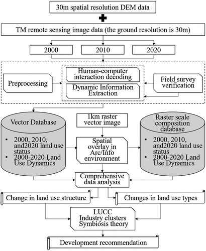
This study adopts the Resource and Environment Science and Data Center, Institute of Geographic Sciences and Natural Resources Research, Chinese Academy of Science (IGSNRR, CAS) (http://www.resdc.cn/) 30 m spatial resolution DEM data provided in the TM remote sensing image data in 2000, 2010, and 2020 (the ground resolution is 30 m). The DEM data is used as a reference, and the geometric accuracy correction, data fusion, image alignment, and RGB false color synthesis are performed on the remote sensing image data in ENVI 5.1 platform to obtain the best visual interpretation of the remote sensing image, and thereafter, the remote sensing image is cropped according to the administrative boundary zoning vector map of Zhangjiajie to build a database of land use changes in Zhangjiajie for the three periods mentioned above. Zhangjiajie is a typical mountainous tourism city, and its land for tourism development is mainly based on woodland, grassland, and water. This study is based on China’s “Current land use classification (GB21010-2017)” (), with reference to the primary classification of the Land Use/Land Cover Classification System of the Chinese Academy of Sciences (). Considering the characteristics of remote sensing image interpretation, and the actual situation of Zhangjiajie, the land classification was regrouped before image analysis. To reduce the meaningless workload, this study combined the two criteria, merged woodland and orchard land, and merged urban and rural, industrial and mining, residential, transportation, and administrative land into construction land. Finally, six types of land cover were formed: cultivated land, woodland, grassland, water area, construction land, and unused land.
Table 1. Current land use classification.
Table 2. Land Use/Land Cover Classification System of the Chinese Academy of Sciences.
2.4. Methods
The TM digital images of 2000, 2010, and 2020 were decoded using a human-computer interaction fast extraction method of land use change remote sensing information based on the 3-phase Zhangjiajie land use change database (Liu et al. Citation2014). Simultaneously, the classification results were manually visually interpreted and corrected with the aid of topographic maps, AMAP (Gaode map), the Zhangjiajie Urban Master Plan (2007–2030), and the Zhangjiajie Territorial Spatial Master Plan (2020–2035). ArcGIS10.2 was used to implement the analysis of land use dynamic change, spatial overlay, and transformation. To ensure the quality of interpretation and consistency of the acquired data, quality checks need to be performed for each period (Zhang et al., Citation2012). In this study, two field surveys were conducted to verify the accuracy of land use data in Zhangjiajie, and the field surveys covered approximately 33% of the city area. Altogether, 100 GPS points were collected to verify the accuracy of land use data in 2020, of which 87 indicated correct interpretation with an accuracy of 87%. The accuracy of land use data in 2000 and 2010 was verified with the help of relevant information and relevant plans, and 80 verification points were selected respectively, with an accuracy of 86.25% and 90%.
Land use classification 1 km raster percentage component data is an effective way to fuse spatial data for regional scale land use change analysis (Geist and Lambin Citation2001; Liu et al. Citation2001, Citation2009). The land use dynamic map was vector raster divided into 1 km units on ArcGIS (). The percentage of area occupied by each land use dynamic change type was recorded in each 1 km raster, and the dynamic change area of each land type within each raster and the conversion area between types were obtained. Thereafter, the land use change calculation method and the spatial superposition and transposition analysis methods were used to calculate the land use change in Zhangjiajie.
(1) Single land use type dynamics calculation. The dynamic rate of a single land use type expresses the change in the quantity of a certain land use type within a certain time frame in a study area, the formula is:
Where, K is the dynamic rate of a certain land use type during the study period; are the area of a certain land use type at the beginning and end of the study period, respectively; T is the time period of a certain land use type change, and when the time period of T is set to year, the value of K is the annual change rate of a certain land use type in the study area (Wang and Bao Citation1999; Dong et al. Citation2021).
(2) Integrated land use dynamic calculation. The integrated land use dynamic can quantitatively describe the rate of regional land use change (Chen, Tong, and Guo Citation1998; Liu et al. Citation2002; Ma and Jin Citation2014). The model is:
Where, is the annual rate of land use change in the study area,
is the area of land use type
at the initial time of monitoring in the study area,
is the absolute value of the area of type
land use type converted to non-type
land use type during the monitoring period in the study area, and
is the length of the monitoring period.
(3) Spatial superposition and transposition analysis. In ArcGIS10.2 by analyzing the spatial superposition and transposition of the land use type map of any two phases, the land use transfer matrix of any two phases in Zhangjiajie can be obtained. Its theoretical model is:
Where, is the transfer matrix of quantitative relationship after mutual transformation of land use types,
are any phase II land use map. This model is mainly used to reveal the types of land use changes and their spatial distribution changes (Zhu et al., Citation2017).
3. Results
3.1. Change of basic structure of land use and its spatial distribution
Through the interpretation of three remote sensing images of Zhangjiajie in 2000, 2010, and 2020, the spatial distribution map of the overall land use pattern of Zhangjiajie in recent 20 years () was obtained. It is found that the land use types of Zhangjiajie are mainly forest land, cultivated land and grassland, indicating that the basic land use structure of Zhangjiajie is mainly forestry, agriculture, and animal husbandry production, which is more in accordance with the natural and geographical conditions of Zhangjiajie and the characteristics of economic and social development.
Figure 2. Land use type of Zhangjiajie from 2000 to 2020.
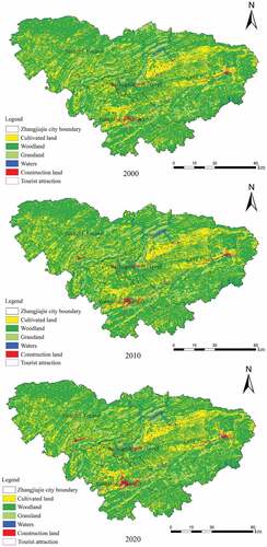
In terms of spatial distribution, cultivated land is mainly concentrated in the central area of Cili County and the Yongding District, having plains, basins with low altitude, and mountainous and hilly areas with small overall fluctuation; woodland and grassland are mainly distributed in the northern mountainous area of Sangzhi County, Wulingyuan Scenic Area in the middle, Tianmen Mountain tourist attraction in the south, and the eastern area of Cili County with Wulei mountain tourist attraction as the core; construction land is mainly distributed in the central urban areas of Yongding District, Wulingyuan District, Sangzhi County and Cili County, and other scattered areas. The water system comprises Lishui river and Loushui river. The two water systems meet in Cili County, and the Jiangya reservoir has been built in Cili County.
In terms of area () forest land is the largest. In 2000, the area of Zhangjiajie was 9653 km2, including 615,186.72 ha of forest land and 225,936.27 ha of cultivated land. By 2020, the area was 9533.87 km2 (Zhangjiajie Territorial Spatial Master Plan (2020–2035)), including 615,843.45 ha of forest land and 225,715.23 ha of cultivated land. The area of forest land increased by 656.73 ha and the area of cultivated land decreased by 221.04 ha. The area of construction land and grassland has changed significantly. The area of construction land has doubled from 3802.23 ha in 2000 to 8333.37 ha in 2020. The grassland area decreased from 99,291.87 ha in 2000 to 93,188.43 ha in 2020. From 2000 to 2020, the water area expanded from 9475.38 ha to 10,592.10 ha.
Table 3. Land use types of Zhangjiajie from 2000 to 2020 (ha).
3.2. Changes in land use dynamic rate
In terms of time series, the overall rate of land use change in Zhangjiajie during 2000–2010 is faster than that in 2010–2020. The absolute values of land use change for all types of land use in Zhangjiajie during 2000–2010 and 2010–2020 are 9.92 km2/a and 5.12 km2/a, respectively, and the combined land use dynamic rate is 0.0519% and 0.0268% (). It indicates that the urbanization process of Zhangjiajie was fast and the overall development degree was high during 2000–2010. Wulingyuan Scenic Area was selected as the first AAAAA tourist attraction in China in 2007, which drove the construction of leisure tourism infrastructure, and continuous improvement of supporting tourist scenic spots, leisure and entertainment facilities, high-end hotels, diversified B&Bs, and other service facilities. The 2010–2020 land use change in Zhangjiajie slowed down in absolute value and land use dynamic rate. In 2015, Zhangjiajie was included in the pilot list of new urbanization in Hunan Province, focusing on a new way of urbanization development that is more intensive, intelligent, green, and low-carbon. In terms of tourism development, in 2013, the municipal government proposed the strategy of “improving Zhangjiajie and creating an upgraded version,” focusing more on upgrading of existing projects and facilities rather than expanding construction. In general, during the two decades of urbanization and tourism development in Zhangjiajie, construction land is the type of land use with the fastest growth and the largest change in area.
Table 4. Changes in dynamic rate of land use types.
3.3. Changes in land use types
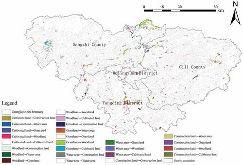
Based on the perspective of land use type change, in general, the land use transformation of Zhangjiajie from 2000 to 2020 is evident (), with a large transformation area, which mainly occurs in the middle of Yongding District, the west of Sangzhi County, the junction between the northeast of Sangzhi County and Hubei Province, and the junction between the east of Sangzhi County and Cili County. As the main urban area of Zhangjiajie, Yongding District has converted more grassland and forest land into construction land in the past 20 years. The change of land types in the western area of Sangzhi County has changed from grassland to forest land, and forest land to cultivated land. At the junction of Sangzhi County and Hubei province in the northeast and Cili County in the east, a large area of grassland is transformed into forest land and forest land into cultivated land.
Figure 3. Spatial distribution of land uses changes in Zhangjiajie from 2000 to 2020.
3.4. Changes in spatial of blue and green
The data on land use change in Zhangjiajie from 2000 to 2020 were processed and analyzed (), and considering woodland and grassland as green space and water area as blue space, the change of blue-green space in Zhangjiajie was derived (). From 2000 to 2010, the area of blue-green space in Zhangjiajie decreased by 3317.58 ha, of which the water area increased by 1075.77 ha and the green area decreased by 4393.35 ha. From 2010 to 2020, the blue-green space indicated a decreasing trend, with a total area of 1012.41 ha, of which the water area increased by 40.95 ha and the green area decreased by 1053.36 ha. With the development of urbanization, people’s demand for land has changed from cultivated land to construction land. With the development of economy, people’s use of land resources is increasing gradually. Owing to the complex landform of Zhangjiajie, the transformation of construction land mostly comes from the increase in grassland development, to meet the land required for the process of urbanization. From 2000 to 2020, the grassland area decreased by 6103.44 ha. However, from 2000 to 2020, the area of forest land increased by 656.73 ha, and the area of water body increased gradually owing to the guidance of national policies such as returning farmland to lakes. From 2000 to 2020, the water area increased by 1116.72 ha.
Figure 4. Spatial change of blue and green in Zhangjiajie.
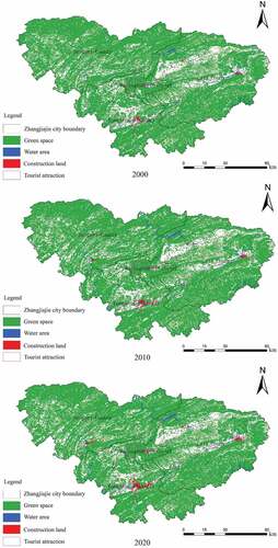
Table 5. Changes in spatial of blue and green (ha).
Overall, from 2000 to 2020, the area of blue-green space in Zhangjiajie decreased by 4329.99 ha and the area of construction land increased by 4531.14 ha. The proportion of urban blue-green space has increased from 75.75% in 2000 to 75.29% in 2020. Compared with the developing areas of the city, Zhangjiajie has expanded its building area more than two times in 20 years, however, its urban blue-green space ratio has only decreased by 0.45%, and its ecology has been maintained, with no major changes in ecological land macroscopically.
4. Discussion and recommendation
4.1. Urban-tourist attraction-township land use changes process
Zhangjiajie is a typical mountain tourism city. Zhangjiajie Wulingyuan Core Tourist Attraction refers to Wulingyuan Scenic Area, which comprises the Zhangjiajie National Forest Park, Suoxiyu Nature Reserve, Tianzishan Nature Reserve, and Yangjiajie Tourist Attraction (Cheng et al. Citation2013), which cover an area of 369 km2, with more than 3,000 strange mountains and peaks Among them, there are 243 with altitudes above 1,000 meters (Xia Citation2006), with an average annual tourist reception of more than five million people (Department of resource development, Ministry of Culture and Tourism of the People’s Republic of China Citation2020). Since 1996 the Zhangjiajie Municipal Government proposed the “Tourism Driven Strategy” and the first tourist train “Zhangjiajie” in Hunan province was launched. Up to now, the core tourist attraction of Wulingyuan in Zhangjiajie has 5 golden signboards including world natural heritage, a world geological park, a national forest park, a 5A-level tourist attraction, landscape, and famous scenery.
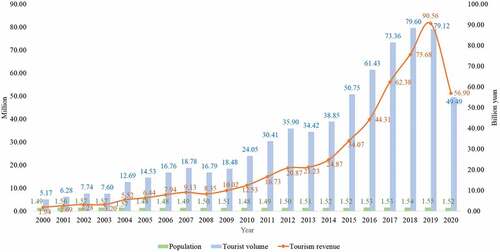
The changes of land use structure, spatial distribution, dynamics rate, types and blue-green space in Zhangjiajie from 2000–2020 indicate that the construction land in urban area grew faster during the 20-year period, especially in Yongding district, the downtown area, and Wulingyuan district, where the core tourist attractions are located, doubling the amount of construction land growth. Comparing the data on population, tourism revenue, and tourist volume in Zhangjiajie from 2000 to 2020 (), combined with other scholars’ studies on the relationship between land use changes and the tourism industry (Zhou and Sun Citation2014; Sun and An Citation2014; Du and Sun Citation2015; Shi et al. Citation2015), it is evident that the development of tourism and land use changes indicate a high degree of synchronization in time. It is worth noting that in 2020, Zhangjiajie recorded a huge decline in tourism revenue and tourist volume owing to the impact of the COVID-19 pandemic, however, the data of 2019 can still be referred to.
Figure 5. Changes of population and tourism income in Zhangjiajie from 2000 to 2020.
Based on the perspective of industrial development, the land use of cities, tourist attractions and towns in Zhangjiajie mainly presents three change processes and trends. (1) As Zhangjiajie is located in a mountainous area with limited cultivated land and little comparative advantage in developing agriculture, the demand for agricultural land is reduced, and the reduced cultivated land is mainly transformed into tourism land with high utilization rate and forest land in response to the policy of returning farmland to forest (Zhu et al., Citation2017).
(2) Zhangjiajie is a city built for tourism. It is also the first demonstration area of national ecological civilization. It has high requirements for ecological and environmental protection. It has a small industrial scale. In recent years, it has eliminated backward industrial production capacity and cleared idle factories. After market circulation, most of the industrial land has been transformed into tourist land. (3) Zhangjiajie is an internationally renowned tourist destination city. The annual number of tourists has reached record high figures, tourism investment and tourism income have continued to grow, the demand for tourism construction land has continued to increase, and the high comprehensive benefits of tourism land have accelerated the transformation of agricultural land and industrial land, especially the towns around the DCC, to tourism construction land. The core attraction of Zhangjiajie tourism is mountain sightseeing and leisure tourism. Its development cannot be separated from the support of agriculture. Under the triple action of tourism development demand, the restrictive requirements of the state regarding the amount of cultivated land and ecological security requirements, the total amount of transformation from township agricultural land to construction land and forest land in urban areas and tourist attractions can be controlled accordingly.
4.2. Development dilemma of townships around the DCC
In the more than 20 years of the vigorous development of the core tourist attraction of Wulingyuan, Zhangjiajie has also achieved positive and fruitful results in its urban social and economic development (Ma and He Citation2016). However, with the rapid development and increasing influence of the tourism industry in the DCC, the external traffic of the DCC has been continuously improved, and foreign tourists have been arriving at a quick pace, though they divert gradually. Consequently, problems such as insufficient supply of road traffic in urban scenery, overloaded entrance and exit capacity of tourist attractions in municipal districts, and shortage of land supply are becoming more evident and prominent. However, the development of the townships around the DCC is seriously insufficient, the industry is not systematic, and it is unable to support the tourism development of the supporting DCC. The proportion of people who go out to work is relatively high, the infrastructure such as transportation is backward, and the capacity of ticket stations of tourist attractions is not balanced. The development has fallen into the embarrassing situation of “the places that are close to popular landscape are not becoming popular” and “darkness under the light.”
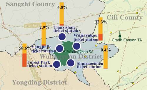
(1) The bottlenecks of internal traffic supply in the era of “Double High.” In the “double-high” era of high-speed railway and highway, the traffic pattern of Zhangjiajie is gradually taking its shape (Wang and Xu Citation2018). There are four expressways and four high-speed railways passing through the industrial belt around the city and the tourist attraction. It is the most convenient area in Zhangjiajie. Among them, there are five entrances and exits for the expressway and two stations for the high-speed railway. However, currently the five ticket stations of the Wulingyuan Scenic Area are not uniform in terms of passenger flow distribution (). Evaluating 2016 data as an example, the passenger flow at the south entrance of the National Forest Park near the urban area and the entrance of Wujiayukou on Jundiping Sub-district, where the Wulingyuan District Government is located accounts for 91.9% of the total passenger flow, and the significant difference in passenger flow distribution has led to the poor accessibility of tourist attractions. The quick arrival of the outside world brought about by the “double height” has exacerbated the real contradiction of “tourism can’t get in the tourist attraction and tourism can’t get out of tourist attractions” tourist attractions and city, and the transportation facilities such as parking lot are seriously insufficient.
Figure 6. Proportion of tourists at the five ticket stations of tourist attraction.
(2) The bottleneck of township development under the diversified growth of consumer demand. With the upgrade in consumption demand becoming the new normal of our country’s economy, the strong growth in consumption demand is manifested in three aspects: ① with the increase in urbanization rate, population growth has brought about the improvement of overall consumption level and capacity; ② the localization demand of the external population led by tourism has increased, and the per capita tourism consumption capacity has increased, which has multiplied local consumption benefits; ③ the type of tourism activities has changed from a single sightseeing type to a complex type such as leisure and vacation, and this would bring diversification in consumer demand. During the “Thirteenth Five-Year Plan” period, the number of tourists and tourism revenue in Zhangjiajie continued to increase. In 2019, the number of tourists exceeded 79.123 million, and the total tourism revenue was 90.560 billion yuan, with an increase of 20.09% and 28.38% respectively (Zhangjiajie Municipal People’s Government, Citation2020). It ranks first among the same type of tourist cities nationally. However, in stark contrast to the vigorous development of DCC, the endogenous drive of bonus area which is the towns and towns around the city and tourist attractions is insufficient.
(3) The bottleneck of mountain land uses under the improvement of urbanization level. In 2019, the urbanization rate of Zhangjiajie was 50.5%, far lower than the national urbanization rate of 60% and the urbanization rate of Hunan Province of 57.22% in the same period. There is still scope for improvement in the level of urbanization. With the continuous growth of the tourism economy, the demand for land is gradually increasing. With the increasing demand for land, the pressure on land supply in Zhangjiajie is prominent. From the perspective of natural conditions, mountains in Zhangjiajie account for 76% of the total area, and more than 40% of the total area is prohibited development area, and the available land is limited. Whereas, various types of protected areas account for 7.4% of the total area (Zhangjiajie former Bureau of Land and Resources Citation2015), the land ecological environment in some areas has deteriorated, and the situation of cultivated land protection is serious. In addition, the land use is inefficient and extensive, and there is an urgent need to change the land use model and management method (Zhu et al., 2017a; Zhu et al., 2017b; Ma and Jin Citation2014).
(4) Green development tasks under the national ecological civilization construction. Maintaining national ecological security is the historical mission of Zhangjiajie. The requirements of the main ecological function area for the biological diversity and soil and water conservation ecological function area of Wuling Mountains are “expanding the scope of natural forest protection, consolidating the achievements of returning farmland to forest, and restoring vegetation and biodiversity” (Hunan Provincial People’s Government Citation2018). The requirements of the ecological civilization pilot demonstration area for the Wuling Mountain area are to “explore the property rights and control system of natural resources assets, explore the evaluation and assessment system for leading cadres, and explore innovate the regional linkage mechanism.” Simultaneously, promoting green development is Zhangjiajie’s own need. It is affected by the natural environmental such as topography and landforms, environment policy of national ecological pattern, and cultural conditions such as historical development. Green development is required in all aspects such as industry, ecology, energy, facilities, and architecture.
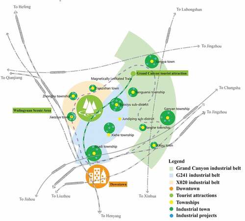
4.3. Analysis of the development of townships around the DCC
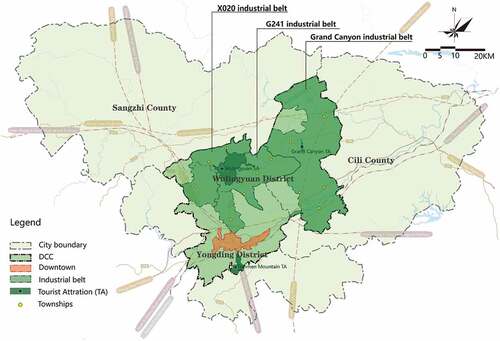
There are 12 small townships around DCC. Based on the theories of industry clusters and symbiosis, from the perspective of system development, the 12 townships can be divided into three industrial belts based on the main traffic axes (). These are the industrial belts in the scenic area around the Grand Canyon, along the 241 National Road (G241), and along the 020 county road (X020). The total planned area is about 1110 km2. Among them, the industrial belt around the Grand Canyon tourist attraction refers to the area with Luci-Zhangxin expressway as the axis, including three townships, two towns and 92 villages, including Yanghe township, Ganyan township, Sanguansi township, Xikou town and Jiangya town, with an area of about 594 km2. The industrial belt along G241 refers to the area with G241 as the axis, including two townships, two sub-districts and 34 villages such as Shadi township, Xiehe township, Jundiping sub-district and Suoxiyu sub-district, with an area of about 258 km2. The industrial belt along X020 refers to the area with X020 as the axis, including one township, two towns and 42 villages such as Jiaoziya town, Tianzishan town and Zhonghu township, with an area of about 258 km2.
Figure 7. Location diagram of three industrial belt.
In view of the development dilemma, the development focus of the three industrial belts should be on multi-perspective analysis, multi-relationship deconstruction, and multi-path coordination.
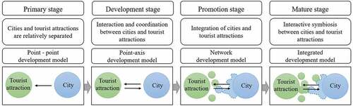
(1) Multi-perspective analysis: The first perspective is the overall development of regional industries based on dislocation. The common feature of the industrial belts around the Grand Canyon Scenic Area, along the G241, and the X020 is their unique location around the city and tourist attractions. Based on the perspective of dislocated regional industry overall planning, to build characteristic industrial townships and explore the integrated development model of cities, tourist attractions and townships. The second is the perspective of “tourism plus” industrial integration. With the background of global tourism, it is relying on the acceleration of the development momentum of the tourism industry in the entire region, building an industrial chain with “tourism plus” as the core, that becomes an important part of the industrial chain in Zhangjiajie. It is promoting the industrial structure and further optimization of industrial belt that will form a certain demonstration role in the adjustment of the industrial structure and the optimized development of the industry in the underdeveloped areas in the central region. The third is the new urbanization perspective of industrial town integration. Relying on the core tourist attraction and central urban area of Wulingyuan, taking the new urbanization construction as an opportunity, and based on the new urbanization perspective of the integration of industries and towns, to explore the development and construction of the surrounding towns around the super-large tourist attraction in terms of industrial development, urban construction, employment promotion, and facility construction, and together, it would provide a new spatial development model for the same type of regions in China ().
Figure 8. Development stage model of cities and tourist attractions.
(2) Multi-relationship deconstruction: Based on the development predicament of Zhangjiajie’s DCC and its surrounding townships, three relationships which should focus on the green development of the industrial belt around the city and tourist attractions: ① the spatial functional relationship among the city, the tourist attractions, and the township. Under the goal of “international tourism destination,” the functional positioning and development direction and priority of cities, tourist attractions, and townships should focus on quality improvement, quality assurance, and capacity expansion. ② The industrial differences among three industrial belts. Although the three industrial belts are geographically close, there are differences in location, transportation, resources, and basic industries. The development positioning between the different industrial belts should be well handled, alongside the corresponding resource allocation, space intensification, industrial cooperation, and basic supporting facilities. ③ The synergistic relationship between tourism industry and the green industry. Green industry could refer to the industrial production process which is based on environmental protection considerations, with the help of science and technology, to save resources and reduce pollution with green production mechanisms. Therefore, the green industry includes the tourism industry, however, is not limited to it. The relationship between tourism industries such as tourism travel, accommodation, catering, shopping, entertainment, and comprehensive services and green industries such as agriculture, forestry, culture, sport, and education should be well handled.
(3) Multi-pathway collaboration: ① Integration strategy of the three functional spaces among city, tourist attractions, and township. With the overall goal of building Zhangjiajie’s “international tourism destination,” the tourist attraction emphasizes “quality preservation,” the city emphasizes “quality improvement,” and the township emphasizes “expansion,” to promote the co-construction of production, living, and ecological “three lives,” and to realize urban, tourist attractions, and township integration (Tang, Liu, and Ma Citation2017; Ma and Liu Citation2018). ② “Tourism plus” regional industrial integration strategy. Through the means of “tourism plus” and “plus tourism,” the integration of regional green industries will be realized. ③ The integration strategy of characteristic small-town clusters around Wulingyuan Scenic Area. Considering Wulingyuan Scenic Area as the core, coordinating the development of small towns around the city (Wang and Yu Citation2012), forming characteristic small-town clusters with reasonable layout, clear positioning, division of labor and cooperation, high agglomeration efficiency, large radiation effect, and strong industrial complementarity, and accelerating the speed of new urbanization construction of Zhangjiajie. ④Integration strategy of urban and rural public services and tourism public services. Based on the need for host and guest services, the integration of urban and rural social and tourism public services will be sought in terms of transportation, information consulting, security, logistics, and convenience services, and administrative management.
4.4. Development path of townships around the DCC
4.4.1. Differentiated industrial system
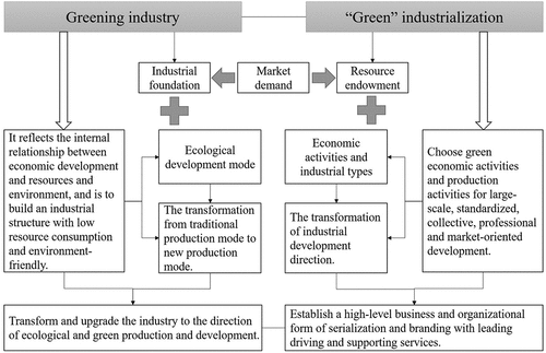
Greening industry is a production method for structural, technological, and management level improvement of ecological efficiency improvement in the process of industrial development (Zhong Citation2015). “Green” industrialization is the transformation of ecological and environmental resources into industries that can generate economic benefits (Qi Citation2016). The plan is to adopt the concept of industrial greening and green industrialization (), rooted in the industrial foundation, resource endowment, market demand, and other conditions of the 12 townships around the city and tourist attractions, and generates the “One Belt, One Industry, Special Zone” as the leading tourism industry idea, with the themes of “Focus on Health,” “Focus on Culture,” and “Focus on Village,” focusing on industrial agglomeration.
Figure 9. Generation of greening industry and “green” industrialization concept system.
First, industrial system along the G241 Industrial Belt. The industrial belt is the core area of double radiation between Zhangjiajie urban area and Wulingyuan scenic area. It is the geometric center of Zhangjiajie city area. G241 and maglev lines pass through the industrial belt. The Shadi Station of the Guizhou-Zhangzhou-Changzhou High-speed Railway is located in this industrial belt, and its location has the characteristics of “accompanying the city with the scenery” and the superiority of the location that makes the industrial belt, the gateway to the core tourist attraction of Wulingyuan, with many performing arts and cultural activities (Huang et al. Citation2018). The lesser the land with more population the land has the characteristics of “half city, half township, half scenery.” The industrial belt has the dual advantages of markets and resources, which are reflected in the market advantage, brought by the location in the urban and landscape radiation circles and the cultural resources advantage formed by the accumulation of intangible cultural heritage. The intangible cultural heritage of the industrial belt is profound, and the cultural performance industry is booming. At present, there are eight performing arts theaters in operation in the city, six of which are concentrated along the G241 Industrial Belt. However, the industrial belt has problems such as shortage of construction land, short existing leading industrial chain and a single structure.
Against the background of high-speed rail and maglev “two high and one line” traffic environment improvement, the urban space “connects with the south and expands to the north,” and the towns along the G241 line have the conditions for opportunistic development. Comprehensively consider the internal and external development environment of the industrial belt, tap resource potential, strengthen ecological protection, rely on the industrial belt’s solid cultural industry foundation, give full play to the industrial belt’s “city-connected scenery” and “maglev high-speed rail” location and transportation advantages, promote the integration of culture and related industries such as agriculture, industry, commerce, logistics, education, taking the construction of cultural self-confidence as an opportunity, vigorously develop cultural performances as the leading, tourism, modern agriculture as the foundation, and modern service industry as the support, and build a “Focus on Culture” as the theme. It is a green industry cluster integrating transportation distribution, cultural performances, science and education training, creative agriculture, processing, and circulation of specialty commodities, and will build the industrial belt along G241 into an “important tourism distribution center in Wulingyuan Scenic Area and a leading area for performing arts and cultural tourism.” Adopt measures such as “circling the city – undertaking urban functions to extend to the north,” “circling the scenery – accelerating the upgrading of tourism services,” “circling the city – reserving environmental landscape space,” “circling the town – accelerating the layout of new industries,” to build a major basic industry, two major industries. The “1 + 2 + 3” industrial system of two key industries and three supporting industries (), and the related paths of various industries are proposed.
Table 6. The industrial system of G241 Belt.
Second, industrial system of the industrial belt in the scenic area around the Grand Canyon. The tourism industry in this industrial belt, led by Zhangjiajie Grand Canyon Scenic Area, is developing rapidly, and most of the high A-level tourist attractions are concentrated in the central and northern regions. It presents the development status of “popular in the middle and less popular at both ends.” The location has the basic characteristics of “away from the city and away from the tourist attractions,” and plays an important role in connecting the middle and the east of the city. The industrial belt around the Grand Canyon Tourist attraction has the advantages of three major resource combinations of canyons, selenium soil, and hot springs, the advantages of abundant land, sufficient land for construction (), and comprehensive transportation advantages such as maglev construction. However, there are four 4A-level tourist attractions in this industrial belt, including Zhangjiajie Grand Canyon, Loujiang Rafting, Longwang Cave, and Jiangya Hot Spring Resort. Except for Zhangjiajie Grand Canyon, other tourist attractions are insufficient to attract tourists (Yin and Lu Citation2018). In 2019, the tourism revenue of the Grand Canyon Tourist attraction was about 290 million yuan, and the number of tourists received 1.7621 million person-times, accounting a low percentage for the city’s 90.56 billion yuan of tourism revenue and 79.123 million in total tourism reception. The number of visitors is far lower than the corresponding indicators of the Grand Canyon. The tourist attractions are insufficient to attract tourists, and it is difficult to form large-scale tourism consumption. It is mainly reflected in the insufficient development of tourism products, and there remains a large gap in catering, accommodation, entertainment, shopping opportunities. The driving force for other industries and the radiation driving for surrounding townships is not strong. All townships are agricultural towns and have useful tourism resources; however, they have not yet been transformed into the advantages of tourism industry development. Insufficient integration between industries, primitive and single agricultural development, low scale, intensification, and specialization of development, insufficient market transformation of agricultural products, especially insufficient integration with the needs of local tourism development, make it difficult to meet the needs of tourism development for local agricultural products. The development of planting and breeding areas and tourist attractions is relatively independent, the driving effect of tourist attractions on the development of surrounding industries has not yet appeared, and the development trend of mutual promotion between industries has not yet formed.
Table 7. Land use indicators of townships in industrial belt around the Grand Canyon in 2020.
Give full play to the advantages of resource combination, land reserve and comprehensive transportation in the industrial belt, relying on well-known tourist attractions such as the Grand Canyon, combined with the resource conditions and development foundation of each township in the industrial belt, grasp the national development strategy of “Healthy China,” and make it clear that health preservation first, and the development idea horizontal integration and vertical extension, focusing on the development main line of upgrading the stock and focusing on the increment and innovation, establishes the development of green and healthy industries, and taps the industrial development potential of the eastern area around the Grand Canyon. Around the theme of “Focus on Health,” an industrial system based on selenium-enriched organic agriculture, focusing on traditional Chinese medicine health care, fitness health care, ecological health care, industry system of trade logistics, financial insurance, and life services as supporting to realize the upgrading transformation of the regional image, development concept and development method of the industrial belt ().
Table 8. The industrial system of the Grand Canyon belt.
Third, industrial system of the industrial belt in the scenic area around the X020. The industrial belt is located in the north of the urban area and in the west of Wulingyuan Scenic Area. The overall landform is “two mountains and one valley,” with hills, mountains, and other landforms as the main landforms, and there are many mountains and streams in the territory. Three relative advantages at a certain scale: two major tourist attractions adjacent to Tianzi Mountain and Yangjiajie, is the western gateway area of Wulingyuan Scenic Area; high-quality rice and high-quality vegetables and fruit are prominent; the tourism service industry represented by homestays. Simultaneously, there are problems such as insufficient traffic capacity, insufficient accessibility, single agricultural structure, and low added value. It is manifested in the fact that only provincial highway S228 is connected to the urban area; poor connection with the other two ticket stations of the tourist attraction, and no connection with the other two industrial belts; the entire agricultural industry chain system has not yet been established, the integration with the secondary and tertiary industries such as tourism, processing and logistics is insufficient, the value of mountain agriculture has not yet emerged, and the incidence of rural poverty is relatively high. However, against the background of high-speed rail and its station construction, the country’s strong support for the development of the rural accommodation industry and the strong driving effect of the diversion and dredging of super-large tourist attractions on the surrounding development, the industrial belt will play an important role in the tourist diversion of Wulingyuan Scenic Area. Based on the natural ecological environment of “Wuling Taoyuan” in the industrial belt, the advantages of tourism resources that complement each other’s nature and culture, the industrial advantages represented by mountain agriculture and rural accommodation, and rooted in the cultural background of the original villages of the industrial belt, give full play to the mountain agriculture and homestays of the industrial belt. Industrial advantages strengthen the industrial belt’s functions such as leisure agriculture, mountain vacation, tourism reception services, agricultural product processing and logistics, and build the industrial belt into a green industrial belt with the theme of “Focus on Village,” with exquisite agriculture, boutique homestay industry, logistics and other functions. It is a green development belt of rural tourism that focuses on the development of “agriculture and tourism integration.” Adopting guidelines such as “integrated development of homestays, small farmers, and culture,” “developing stock, economical and intensive land use,” “stepped development according to local conditions and minimal ecological disturbance,” “upgrading and upgrading, and high-quality development based on an international perspective.” The “1 + 1 + 2” industrial development system is based on “mountain planting and breeding industry,” “mountain leisure and vacation industry” as the focus, and “tourism supporting service industry and agricultural product logistics and distribution industry” as the supporting “Focus on Village” industry system ().
Table 9. The industrial system of X020 Belt.
4.4.2. Conception of city-tourist attractions-township green traffic rings
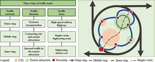
Aiming at the development predicament of towns and towns around the DCC, with the goal of breaking through bottlenecks and traffic first, some functions of the current urban center and high A-level tourist attractions should be relieved, and taken over by the surrounding towns. Consequently, around the central urban area and the Wulingyuan Scenic Area, an all-weather, panoramic and sustainable “sightseeing-type ordinary railway train and property development” will be built in series with 12 townships (), to ease the pressure on the ecological capacity of Wulingyuan Scenic Area, tourism services, transportation distribution, to form three-dimensional tourism, and enhance network effects and scale benefits. In addition, relying on the construction of maglev high-speed traffic, a secondary transfer station will be built along the maglev line to connect tourists carried by the maglev high-speed rail to various characteristic tourist attractions and tourist areas (). The functional configuration of the connection station mainly includes tourism bus parking lot and tourist service station.
Figure 10. Zhangjiajie transportation vision.
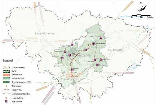
Figure 11. Conceptual diagram of comprehensive transportation.
4.4.3. “Dual-core driver” spatial structure and layout
The overall spatial layout of Zhangjiajie industrial belt around city and tourist attraction is multi-ring with two cores and three belts with multiple towns (). “Multi-ring traction,” that is, relying on high-speed railways, expressways, maglev trains, and sightseeing trains to build a traffic development ring around the city and surrounding scenery in the central area of the city, forming a large pattern of regional tourism traffic; dual-core driving strategy, that is relying on the central urban area and the core tourist attraction of Wulingyuan, implement the dual-core driving strategy; “Three Belts Synergy,” namely the “Focus on Health” industrial belt around the Grand Canyon Scenic Area, the G241 “Focus on Culture” industrial belt, and the X020 “Focus on Village” industrial belt form three industrial lines around the city, the east, the middle and the west; “multi-town support” surrounds the center of the city, with surrounding Xikou Town, Yanghe Township, Ganyan Township, Sanguansi Township, Jiangya Town, Shadi Township, Xiehe Township, Jundiping Sub-district, Suoxiyu Sub-district, Jiaoziya Town, Zhonghu Township, Tianzishan Town and other 12 townships and sub-districts being the key development targets, forming a small town development system that surrounds the city, surrounds the tourist attractions, divides labor, and cooperates.
Figure 12. Conceptual model of spatial structure of township industrial belt around DCC.
5. Conclusion
This study analyzes the dynamic changes of land use and its causes and impacts based on the data of land use changes in Zhangjiajie for three periods of 2000, 2010, and 2020. The study revealed:
(1) The land use pattern of Zhangjiajie has changed greatly during 2000–2020, with forest land, grassland and arable land still accounting for the most types of land; the largest increase in construction land; the maximum conversion of arable land and grassland into construction and forest land; and an overall decrease in blue-green space, with the proportion dropping from 75.75% in 2000 to 75.29% in 2020, which still exceeds the requirement of 70% of blue and green space in many important cities such as Xiong’an and Tianjin. This indicates that Zhangjiajie’s ecological environment is maintained relatively well, and no changes in the macro pattern are found.
(2) Zhangjiajie’s land use change and tourism development indicate a high degree of synchronization in time. There are three reasons: First, Zhangjiajie is located in a mountainous area, with limited cultivated land and reduced demand for agricultural land. The reduced cultivated land is mainly transformed into tourism construction land with high utilization rate and forest land in response to the policy of returning farmland to forest. Second, owing to the requirements of ecological protection, the industrial scale of Zhangjiajie is limited, and idle industrial land is transformed into tourism construction land. Third, highly comprehensive benefits of tourism construction land have accelerated the transformation of agricultural land and industrial land – especially the townships around DCC – to tourism construction land. It indicates that the fundamental driver of urban development and land use change in Zhangjiajie, a city with mega scenic spots, is the spillover effect of the tourism industry.
(3) Although the townships around DCC have beautiful landscape, their development is hindered by the topography and landscape restrictions, and the spatial crowding of urban and tourist attraction development. Based on the theory of industrial clusters and symbiosis, it is suggested that the towns around DCC should be developed in combination according to their location and resource advantages. Adopting the differentiated industrial system and discarding the economic development model to develop tourism-related service industries, undertaking the overflow of benefits from cities and tourist attraction, and building the symbiotic development of central city – mega scenic spots – township areas as one. The development dilemma of the townships around Zhangjiajie DCC reveals that the booming development of urban tourism and scenic tourism limits the development of the surrounding townships, resulting in a prominent dual structure. Isolated large-scale tourism development in cities and tourist attraction may lead to development saturation and experience the same development bottleneck. Therefore, dividing the townships around DCC into industrial belts and connecting them through comprehensive transportation networks to form a symbiotic downtown-tourist attraction-township industry is the logical path to break through the development bottleneck.
However, there remain certain limitations to this study. Discussing the development of townships around the super tourist attraction through the representation of land use change also has certain limitations and lacks more data support, including township industry indicators, population outflow indicators and so on. The development of the industrial system in townships also needs the support of policy mechanisms, including the government-led establishment of a cross-sector, cross-industry and cross-regional township industrial development system and the integration of various plans. In addition, all relevant departments should actively cooperate in accordance with the division of functions and build a variety of platforms for the public to participate in the entire process, which are elements that can be further explored in the future.
Acknowledgments
This research also received support from green development planning project of 3 industrial belts of Zhangjiajie.
Disclosure statement
No potential conflict of interest was reported by the author(s).
Data availability statement
The raw/processed data required to reproduce these findings cannot be shared at this time as the data also forms part of an ongoing study. https://www.resdc.cn
Additional information
Funding
Notes on contributors
Ting Wang
Ting Wang is an Assistant Professor at the School of Architecture and Urban Planning, Beijing University of Civil Engineering and Architecture. Her research interests include urban planning, planning and governance of urban and rural tourism space, tourism ecological planning and design
Jiawen He
Jiawen He is a graduate student at the School of Design, The University of Melbourne
References
- Bai, R., Y. Shi, and Y. Pan. 2022. “Land-Use Classifying and Identification of the Production-Living-Ecological Space of Island Villages—A Case Study of Islands in the Western Sea Area of Guangdong Province.” Land 11 (5): 705. doi:10.3390/land11050705.
- Bary, A. D. 1879. Die Erscheinung der Symbiose. Strasbourg: Privately printed.
- Braun, P. (2005). “Creating Value to Tourism Products through Tourism Networks and Clusters: Uncovering Destination Value Chains.” Conference Global Tourism Growth: A Challenge for SMEs, 2005 OECD & Korea, Gwangju, Korea, 1–11.
- Chen, Z. G. 2010. “A Study on Mechanisms of the Interactions between Land Use Change and Tourism Development: A case of Yangshuo County.” Guangxi Resources Science 32 (10): 1980–1986.
- Cheng, C., Y. Xiao, Z. Y. Ouyang, and E. M. Rao. 2013. “Natural Landscape Valuation of Wulingyuan Scenic Area in Zhangjiajie City.” Acta Ecologica Sinica 33 (3): 0771–0779. doi:10.5846/stxb201203270418.
- Chen, Y. F., Y. Liu, and Y. R. Li. 2019. “Agricultural Development Status and Industrial Prosperity Path under the Background of Rural Revitalization in China.” Geographical Research 38 (3): 632–642.
- Chen, L. D., Y. Liu, Y. H. Lv X. M. Liu, and B. J. Fu. 2008. “Landscape Pattern Analysis in Landscape Ecology: Current, Challenges and Future.” Acta Ecologica Sinica 28 (11): 5521–5531. DOI:10.1016/S1872-2032(09)60011-1.
- Chen, S. P., Q. X. Tong, and H. D. Guo. 1998. Mechanism of Remote Sensing Information. Beijing: Science Press.
- Dang, A. T., L. Kumar, M. Reid, and H. Nguyen. 2021. “Remote Sensing Approach for Monitoring Coastal Wetland in the Mekong Delta, Vietnam: Change Trends and Their Driving Forces.” Remote Sens 13 (17): 3359. doi:10.3390/rs13173359.
- Deng, J. S., K. Y. Wang, Y. Hong, and J. G. Qi. 2009. “Spatio-temporal Dynamics and Evolution of Land Use Change and Landscape Pattern in Response to Rapid Urbanization.” Landscape and Urban Planning 92 (1): 187–198. doi:10.1016/j.landurbplan.2009.05.001.
- Department of resource development, Ministry of Culture and Tourism of the People’s Republic of China. (2020). Development report of China’s tourist attractions (2019). Beijing: China Tourism Press.
- Dong, X. B., D. C. Zhuang, Y. F. Liu, Y. L. Wang, Y. Y. Zou, and J. Fan. 2021. “Study on Land Use Change and blue-green Space Evolution in Zhangjiajie under the Background of Urban Expansion.” Rural Economy and Science 32 (18): 1–4.
- Du, M. N., and G. N. Sun. 2015. “Statistical Analysis on 30 Years Interaction of International “Trade, Transportation and Tourism”.” Human Geography 2: 155–160.
- Fetai, B., D. Grigillo, and A. Lisec. 2022. “Revising Cadastral Data on Land Boundaries Using Deep Learning in Image-Based Mapping.” ISPRS International Journal of Geo-Information 11 (5): 298. doi:10.3390/ijgi11050298.
- Geist, H. J., and E. F. Lambin (2001). “What Drives Tropical Deforestation? A meta-analysis of Proximate and Underlying Causes of Deforestation Based on Subnational Case Study Evidence (=LUCC Report Series; 4).” LUIC International Project Office, Louvain-la-Neuve, 116.
- Global Land Project (GLP). 2005. Science Plan and Implementation Strategy. Stockholm: IGBP Secretariat.
- Greer, T., and G. Wall. 1979. “Recreational Hinterlands: A Theoretical and Empirical Analysis.” In Recreational Land Use in Southern Ontario, edited by G. Wall, 227–245. Waterloo: Department of Geography Publication Series, University of Waterloo.
- Gunn, C. A. 1988. “Vacationscape:DesigningTourists Regions.” In Austin: University of Texas, 110–150. Austin, TX: Bureau of Business Research, The University of Texas at Austin.
- Hammes, D. L. 1994. “Resort Development Impact on Labor and Land Market.” Annals of Tourism Research 21 (5): 729–744. doi:10.1016/0160-7383(94)90080-9.
- Herrick, J. E., K. C. Urama, J. W. Karl, J. Boos, M.-V.-V. Johnson, K. D. Shepherd, J. Hempel, et al. 2013. “The Global land-potential Knowledge System (Landpks): Supporting evidence-based, site-specific Land Use and Management through Cloud Computing, Mobile Applications, and Crowdsourcing.” Journal of Soil and Water Conservation 68 (1): 5–12. DOI:10.2489/jswc.68.1.5A.
- He, C. Y., J. X. Zhang, Z. F. Liu, and Q. X. Huang. 2021. “Characteristics and Progress of Land use/cover Change Research during 1990-2018.” Acta Geographica Sinica 76 (11): 2730–2748.
- Huang, W., F. Meng, Z. M. Zhu, and L. F. Zheng. 2018. “An Empirical Study on the Endogenous Driving Force of Tourism Performing Industry: Taking Zhangjiajie as an Example.” Tourism Tribune 33 (6): 87–98.
- Hu, Q. H., and L. Lu. 2009. “The Progress and Inspiration of Tourism Land Research.” Economic Geography 29 (2): 313–319.
- Hunan Provincial People’s Government. (2012). “The Overall Plan for Tourism Development of Western Hunan Eco Cultural Tourism Circle Passed the Expert Review.” http://www.hunan.gov.cn/hnyw/bmdt/201212/t201 21210_4799819.htm.
- Hunan Provincial People’s Government. (2018). “Notice of Hunan Provincial People’s Government on Printing and Distributing the Red Line of Ecological Protection in Hunan Province.” http://fgw.hunan.gov.cn/gw/tslm_77952/stjs/201807/t2018 0726_5061048.html
- Iacopino, S., C. Piazzi, J. Opio, D. K. Muhwezi, E. Ferrari, F. Caporale, and T. Sitzia. 2022. “Tourist Agroforestry Landscape from the Perception of Local Communities: A Case Study of Rwenzori, Uganda.” Land 11 (5): 650. doi:10.3390/land11050650.
- Jin, S. M., L. M. Yang, P. Danielson, C. Homerd, J. Fryd, and G. Xiana. 2013. “A Comprehensive Change Detection Method for Updating the National Land Cover Database to Circa 2011.” Remote Sensing of Environment 132: 159–175. doi:10.1016/j.rse.2013.01.012.
- Ju, H. R., L. J. Zuo, Z. X. Zhang, X. L. Zhao, X. Wang, Q. K. Wen, F. Liu, et al. 2020. “Methods Research on Describing the Spatial Pattern of Land Use Types in China.” Acta Geographica Sinica 75 (1): 143–159.
- Kuang, W. H., J. Y. Liu, Z. X. Zhang, D. S. Lu, and B. Xiang. 2013. “Spatiotemporal Dynamics of Impervious Surface Areas across China during the Early 21st Century.” Chinese Science Bulletin 14:1–11.
- Liu, C. K. 1996. “Discussion of the Overall Benefits of Urban Agglomeration.” City Urban Problems 2: 9–12.
- Liu, J. Y. 1996. Macro-scale Survey and Dynamic Study of Natural Resources and Environment of China by Remote Sensing. Beijing: China Science and Technology Press.
- Liu, J. Y., W. H. Kuang, Z. X. Zhang, X. L. Xu, Y. W. Qin, J. Ning, W. C. Zhou, et al. 2014. “Spatiotemporal Characteristics, Patterns and Causes of Land Use Characteristics, Patterns and Causes of Land Use Changes in China since the Late 1980s.” Acta Geographica Sinica 69 (1): 3–14.
- Liu, J. Y., M. L. Liu, D. F. Zhuang, Z. X. Zhang, and X. Z. Deng. 2002. “Study on Spatial Pattern of land-use Change in China during 1995-2000.” Science in China: Series D 46 (4): 373–384.
- Liu, M. L., X. M. Tang, J. Y. Liu, and D. F. Zhang. 2001. “Research on Scaling Effect Based on L Km Grid Cell Data.” Journal of Remote Sensing 5 (3): 183–189.
- Liu, J. Y., C. X. Zhang, X. L. Xu, W. H. Kuang, M. C. Zhou, S. W. Zhang, R. D. Li, et al. 2009. “Spatial Patterns and Driving Forces of Land Use Change in China in the Early 21st Century.” Acta Geographica Sinica 64 (12): 1411–1420.
- Liu, J. Y., Z. X. Zhang, X. L. Xu, W. Kuang, W. Zhou, S. Zhang, R. Li, et al. 2010. “Spatial Patterns and Driving Forces of Land Use Change in China during the Early 21st Century.” Journal of Geographical Sciences 20 (4): 483–494. DOI:10.1007/s11442-010-0483-4.
- Li, Z., X. L. Zhang, Y. Chen, and H. B. Li. 2017. “Research on Rural Rejuvenation in China Based on urban-rural Interaction.” Economic Geography 37 (6): 144–150.
- Ma, X. F., and Y. Y. He. 2016. “Spatio-temporal Evolution Characteristics and Mechanism of Tourism Industry Generation of Zhangjiajie City.” Scientia Geographica Sinica 36 (12): 1894–1902.
- Ma, X. L., and Y. L. Jin. 2014. “Study on Counteractive Mechanism between Urban Land Use Change and Tourism Development.” Tourism Tribune 29 (4): 87–96.
- Ma, X. F., and Y. L. Liu. 2018. “Urbanization Response to Tourism and Analysis of Its Influencing Mechanism Based on Three Factors in Zhangjiajie.” Scientia Geographica Sinica 38 (8): 1346–1356.
- Marshall, G. C. 1965. “Translated by Chen Liang, B.” In Economic Theory (Chinese Version), 279–284. Beijing: Commercial Press.
- McMurry, K. C. 1930. “The Use of Land for Recreation.” Annals of the Association of American Geographers 20 (1): 7–20. doi:10.1080/00045603009356913.
- Ning, Z. Z., and Q. Zhang. 2020. “Urban and Rural Element Mobility and Allocation Optimization Under the Background of Rural Priority Development.” Geographical Research 39 (10): 2201–2213.
- Qi, Q. L. 2016. “Sidelights of China County Green Development (Xianju) Forum – In-depth Discussion on the New Concept, New Direction and New Path of County Green Development.” CHINA ECOLOGICAL CIVILIZATION 5: 8–12.
- Shi, P. J., P. Gong, X. B. Li, J. Chen, Y. Qi, and Y. Z. Pan. 2000. Research Method and Practice of Land Use/Land Cover. Beijing: Science Press.
- Shi, Z. Y., B. H. Zhou, J. H. Shen, and L. Zhu. 2015. “Interactions between Inbound Tourism from Nine Asian Countries and Import and Export Trade.” Resources Science 9: 1871–1879.
- Sun, G. N., and J. M. An. 2014. “An Analysis of the Interaction Relation of Tourist and Trade between Mongolia and Inner Mongolia of China.” Journal of Arid Land Resources and Environment 8: 189–195.
- Tang, H., Y. J. Liu, and X. F. Ma. 2017. “Effect Evaluation of Coordinated Development between Tourism Industry and New urbanization–a Case Study of Zhangjiajie.” Economic Geography 38 (8): 1346–1356.
- Tan, X. L., Y. Y. Zhong, J. N. Duan, and H. C. Cao. 2014. “The Change and Driving Forces of Rural Residential Area under the back-ground of Rapid Urbanization: A Case Study of the Changsha-Zhuzhou-Xiangtan Urban Agglomeration.” Scientia Geographica Sinica 34 (3): 309–315.
- Wang, X. L., and Y. H. Bao. 1999. “Study on the Methods of Land Use Dynamic Change Research.” Progress In Geography 18 (1): 81–87.
- Wang, J. Y., and Y. S. Liu. 2009. “Land Use and Land Cover Change and Its Driving Forces in Sanya.” Journal of Natural Resources 24 (8): 1458–1466.
- Wang, Z. F., and S. Xu. 2018. “Influence and Evaluation of Different Traffic Modes on Tourism Efficiency: Taking Zhangjiajie as an Example.” Scientia Geographica Sinica 38 (7): 1148–1155.
- Wang, Z. F., and H. Yu. 2012. “Study on Coupling Development between Development of Tourism Industry and small-town Construction in Zhangjiajie City.” Economic Geography 32 (7): 165–171.
- Weaner, D. B. 1993. “Model of Urban Tourism for Small Caribbean Islands.” Geographical Review 83 (20): 134–140. doi:10.2307/215251.
- Wu, B. H. 2001. “A Study on Recreational Belt around Metropolis (Rebam): Shanghai Case.” Scientia Geographica Sinica 21 (4): 354–359.
- Wu, L. M., Z. F. Huang, F. D. Cao, and W. Zhou. 2015. “Land Use Pattern Evolution and Its Driving Mechanism of an Ancient Town Under the Background of Tourism Urbanization: A Case Study of Zhouzhuang.” Geographical Research 34 (3): 587–598.
- Xia, Z. C. 2006. Research on Development History of Modern Tourism in Zhangjiajie. Changsha: Hunan Normal University Press.
- Xie, P. F., V. Chandra, and K. Gu. 2013. “Morphological Changes of Coastal Tourism: A Case Study of Denarau Island, Fiji.” Tourism Management Perspectives 5: 75–83. doi:10.1016/j.tmp.2012.09.002.
- Xi, J. C., X. G. Wang, Q. Q. Kong, and S. K. Wang. 2016. “From a Traditional Rural Village to the Modern Coastal Resort: Land Use Change in the past 20 Years in Jinshitan and Its Policy Implication.” Human Geography 1:130–139.
- Xu, X. X. 2013. “An Overview of the Theory of Rural Tourism Industry Clusters in China.” Economic Research Guide 18 (20): 264–265.
- Yang, J., Y. C. Li, J. C. Xi, Q. S. Ge, Y. Zhang, and Z. D. Ma. 2014. “The Coastal Tourist Town's Land Use Spatial Pattern Evolution and Driving Forces Under the Background of Tourism Urbanization—a Case Study of Dalian Jinshitan National Tourist Holiday Resort.” Journal of Natural Resources 10: 1721–1733.
- Yin, H. G., and R. Y. Lu. 2018. “On Optimization of Spatial Structure of Zhangjiajie Tourist Attraction in Sontext of all-for-one Tourism.” Journal of South-Central University for Nationalities (Humanities and Social Sciences) 38 (5): 68–72.
- Yuan, C. Q. 1998. Symbiosis Theory – Also on China’s Small Economy. Beijing: Economic Science Press.
- Zhang, Y. F. 2007. Study on the Impacts of Development of Tourism Resources on Land Utilization: Acase of Nanyue County of Hengyang City in Hunan Province. Changsha: Hunan Normal University.
- Zhangjiajie former Bureau of Land and Resources. (2015). “Bulletin on the Main Data Results of the Second Land Survey in Zhangjiajie” http://www.zjj.gov.cn/c37/20160420/i24401.html
- Zhangjiajie Municipal People’s government. (2020). “Zhangjiajie 2019 National Economic and Social Developments Statistical Bulletin.” http://www.zjj.gov.cn/c89/20200604/i554462.html
- Zhangjiajie Municipal People’s government. (2021). “Suggestions on Formulating the Fourteenth “Five Year Plan” for Zhangjiajie’s National Economic and Social Development and the long-term Goals for the Year 2035.” Zhangjiajie daily, January 7, edition 001. http://www.zjj.gov.cn/c32/20210415/i604718.html
- Zhang, Z. X., X. L. Zhao, and X. Wang. 2012. Remote Sensing Monitoring of Land Use in China. Beijing: StarMap Press.
- Zhong, M. C. 2015. “Theoretical Interpretation of the Connotation of Green Industry and Its Development Misunderstanding.” Journal of China University of Geosciences Social Sciences Edition 15 (3): 1–8.
- Zhou, L., and G. N. Sun. 2014. “The Interaction Analysis between Inbound and Outbound Tourism of Japan, Korea and China in the past 20 Years.” Journal of Arid Land Resources and Environment 1: 175–182.
- Zhu, D. G., B. G. Xie, and P. Xiong. 2017. “Spatial-temporal Evolution of land-use Pattern Changes in Zhangjiajie City Based on three-dimensional Landscape Pattern Indices.” Economic Geography 37 (8): 168–175.
- Zuo, B. 2005. “Study on the Tourism Driving Force of Land Use Change.” Journal of Yunnan University of Finance and Economics 21 (5): 106–111.