
ABSTRACT
Marine protected areas (MPAs) are a conservation tool designed to adequately manage and protect marine resources threatened by human activity by addressing both biological and socioeconomic needs. The Irish Sea is a busy waterway under the jurisdiction of six entities (Northern Ireland, the Republic of Ireland, the Isle of Man, Scotland, England, and Wales). Within this body of water there are almost 200 conservation designations across 111 MPA sites, with many sites having multiple designations (national, EU, and international). Data is lacking on the effectiveness of these protected areas in reaching their conservation objectives due to sites being inadequately monitored. The race to meet the 10% marine protected area target set by the Conservation on Biological Diversity, however, may be compromising effective planning. Do multiple designations ensure better protection of the marine environment, or is the Irish Sea home to paper parks, offering little protection? Metadata compiled from the World Database on Protected Areas and conservation reports from MPA managers were used to investigate this question. The results show a positive correlation between the number of designations of a site and the existence of a publicly available management plan. The presence of a management plan was also linked to whether or not site assessments were conducted by the relevant authorities, and sites having multiple designations was weakly correlated with favourable assessment outcomes. The results of this study highlight the need to better understand the requirements of national, regional and international-level conservation designations and how they interact with each other.
Introduction
Marine life is facing increasingly serious threats due to human activity (Halpern et al. Citation2008; Claudet Citation2011; Fraschetti et al. Citation2011; Long et al. Citation2015). Marine protected areas (MPAs) are designed for the conservation of marine life in the face of exploitation and other threats related to human activity. Their effectiveness varies, however, and may be attributed to different factors, such as age or size (Edgar et al. Citation2014). MPAs are designated at the national, regional, and international level to achieve a set of established conservation objectives. This paper argues that multiple designations may contribute to the effectiveness of MPAs in reaching their biophysical goals.
Human activity directly affects marine life through overfishing, coastal pollution, the introduction of invasive alien species, and habitat destruction, with estimates stating that over 60% of global fishery stocks have already collapsed or are overexploited, and an additional one-third are fully exploited (Halpern et al. Citation2008; Fraschetti et al. Citation2011; Nils et al. Citation2014). Greenhouse gases released from the burning of fossil fuels have caused a rise in ocean temperatures and acidification, resulting in coral bleaching, migration of species, biodiversity loss, and rising sea levels (Sanderson et al. Citation2002; Walther et al. Citation2002; Cardinale et al. Citation2012). A wide array of methods is currently applied to manage and protect marine resources, such as ocean zoning, regulating the harvest of species, enforcing catch limits, and establishing MPAs (Levine et al. Citation2015). However, MPAs are increasingly being used for multiple goals, such as sustainable fisheries and economic development (Christie and Pollnac Citation2011). There is no single definition of an MPA, and its role depends on its objectives; for example, some MPAs serve as fisheries reserves, or boxes, which are subjected to seasonal closures, buffer zones, or gear restrictions (WWF Citation2005; Claudet Citation2011). MPAs can be considered ‘statutory,’ meaning they are legally designated by governments, or ‘voluntary’ for those managed by stakeholders and NGOs (WWF Citation2005; Rodríguez-Rodríguez et al. Citation2015a).
The main priority for any MPA is the conservation and protection of natural resources (Pomeroy et al. Citation2005; Claudet Citation2011). This involves the restoration of damaged or overexploited areas deemed crucial to the survival of one or more species. An MPA may also serve to improve the relationship between humans and their environment through the sustainable exploitation of resources (Pomeroy et al. Citation2005; Claudet Citation2011). In other words, they must ensure long-term conservation of species and habitats while also considering ecological, political, economic, and social outcomes. While an MPA’s success can be measured in terms of its contribution to fisheries (Ban et al. Citation2017), fishers tend to oppose the establishment of MPAs (Leleu et al. Citation2012; Morgan Citation2013; Gallacher et al. Citation2016). Potential benefits may nevertheless include an increase in the abundance and biomass of species within the MPA (Abesamis and Russ Citation2005; Fraschetti et al. Citation2011; Leleu et al. Citation2012; Soler et al. Citation2015; Gallacher et al. Citation2016). Indeed, the marine and coastal environment provides various ecosystem services: provisioning services, such as seafood and medicines; regulating services, providing flood protection and carbon sequestration; supporting services, such as nutrient cycling; and cultural services, such as water sports and tourism (Lopes and Videira Citation2013; Potts et al. Citation2014).
Protecting the marine environment and the ecosystem services it provides is necessary for human survival (Costanza et al. Citation2014), but an area does not mysteriously become protected just because it has been designated as an MPA. Its establishment and management should not be taken lightly (Jameson et al. Citation2002). Many MPAs have reportedly had low levels of success, largely due to mismanagement and lack of funding and a race to designate that has resulted in the creation of ‘paper parks’ (Halpern Citation2014). These parks exist in principle without their regulations being enforced; they are protected areas on paper only (Halpern Citation2014). The failure of many MPAs may be attributed to a lack of foresight (Halpern Citation2014). Before deciding to establish an MPA, ecological and socioeconomic factors must be considered to ensure it is successful and sustainable (Nikitine et al. Citation2018). When properly managed, MPAs are a favourable conservation tool. An MPA is considered successful when it can not only maintain or replenish the loss of biomass of a species, but also generate enough revenue from tourism, government funds, and private donations, to be effectively managed and remain fully operational (Jameson et al. Citation2002; Pomeroy et al. Citation2005).
Designation of MPAs was low until 2000 (MPAs made up less than 0.1% of the oceans for most of the 20th century) but has since increased by more than 10 million km2, roughly the size of Canada (OECD Citation2016; Sala et al. Citation2018). The rise in designated sites may be attributed to the ambitious goal set out by the Convention on Biological Diversity (CBD) to achieve a global MPA target of 10% by 2020 (CBD Citation2010; Costello and Ballantine Citation2015; Orlikowska et al. Citation2016). In 2010, the Strategic Plan for Biodiversity 2011–2020 and the Aichi Biodiversity targets were adopted, calling for stronger environmental protection worldwide by setting conservation objectives like the aforementioned target (CBD Citation2010). Aichi Target 11 aims to protect biodiversity and ecosystem services ‘through effectively and equitably managed, ecologically representative and well-connected systems of protected areas and other effective area-based conservation measures’ (CBD Citation2017). However, the CBD does not specify how much protection MPAs must have (Costello and Ballantine Citation2015; O’Leary et al. Citation2016). Similarly, there has been very little progress in determining whether protected areas of any kind (marine or terrestrial) are managed equitably (Schreckenberg et al. Citation2016; UNEP-WCMC, IUCN and NGS Citation2018). Since 2010, the global area of MPAs has doubled, from 2.4% to 5.7% (CBD Citation2017). These figures, however, group together three separate stages of establishing a protected area: announcement of intent to create an MPA; legal designation; and implementation (Sala et al. Citation2018). A more accurate tally of implemented MPAs by the Marine Conservation Institute’s MPAtlas placed this number at 4.8% in October 2019, with 2.2% considered ‘highly protected in no-take marine reserves’ (MCI Citation2019).
There is growing concern that the increase in MPA designations is creating an illusion of marine conservation, as there is a lack of new data to adequately evaluate the ecological effectiveness of MPAs (Edgar Citation2011; Costello and Ballantine Citation2015; Klein et al. Citation2015; Gill et al. Citation2017). It is important to note that the majority of MPAs (94%) allow fishing, and are thus not considered no-take zones, while the proportion of marine reserves (no-take zones) amongst global MPAs is decreasing (Costello and Ballantine Citation2015). Much as there are numerous definitions for MPAs (Briggs et al. Citation2018), the definition of a marine reserve varies from country to country. A marine reserve in Kenya is considered a multiple-use protected area, while in Tanzania the same term applies strictly to fully protected, no-take areas (Wells et al. Citation2016). In the United Kingdom, there are only three statutory Marine Nature Reserves (MNRs) – Lundy Marine Nature Reserve in the Bristol Channel, Skomer Marine Nature Reserve in Pembrokeshire, and Strangford Lough in County Down – and one non-statutory voluntary MNR, located at St. Abbs in Berwickshire, of which only Lundy Island is a no-take zone (UK MPA Centre Citation2007). The designation of these MNRs may indicate an increase in marine regulations but does not necessarily correlate with improved biodiversity conservation (Costello and Ballantine Citation2015).
While many MPAs around the world were established with biodiversity conservation as the primary goal, whether this has been successful remains largely untested (Edgar Citation2011). There is scepticism regarding the success of MPAs and studies were conducted to assess just how effective these conservation zones are (Edgar Citation2011; Rodríguez-Rodríguez et al. Citation2015a, Citation2015b; Álvarez-Fernández et al. Citation2017; Gill et al. Citation2017; Amengual and Alvarez-Berastegui Citation2018). A study by Rodríguez-Rodríguez et al. (Citation2015b) on the management effort of 153 MPAs in the English Channel found that most MPAs received a medium-level of protection. The effectiveness of the designating body had an impact on the level of protection of MPAs: for example, Ramsar sites were found to have low levels of protection, while the French Réserves Naturelles enjoyed high levels of protection (Rodríguez-Rodríguez et al. Citation2015b). A study conducted by Álvarez-Fernandez et al. (Citation2017) on the management performance of MPAs in the Northeast Atlantic found that only 153 of the 550 MPAs had management plans, with a mere 66 being actively managed. Many MPAs lack the resources to meet the requirements for effective and equitable management; in essence, they are underfunded and understaffed (Gill et al. Citation2017; Amengual and Alvarez-Berastegui Citation2018).
Edgar et al. (Citation2014) argue that the most effective MPAs have five key factors in common. These are known as the ‘NEOLI’ (No-take, Enforced, Old, Large, Isolated) features, and successful MPAs present at least four of these five factors. ‘Enforced’ refers to the implementation of rules and regulations which MPA users must abide by to ensure the protection of a site’s species and habitats (Edgar et al. Citation2014). A successful MPA must have an effective implemented management plan, otherwise it is simply a paper park (Agardy et al. Citation2011; Edgar et al. Citation2014; Álvarez-Fernández et al. Citation2017). Staff and budget were also found to be major predictors of conservation impact: MPAs with enough capable staff had 2.9 times greater ecological effects than those without (Gill et al. Citation2017). While there is no standard format for management plans, successful plans involve stakeholders and favour adaptive management (Klein et al. Citation2015; Álvarez-Fernández et al. Citation2017; Gill et al. Citation2017). To improve protected area management and evaluate their success, protected area management effectiveness (PAME) assessments are conducted (Leverington et al. Citation2010). These evaluations increase accountability, help protected area managers to communicate with the public, and assist in resource prioritisation (Ehler Citation2003; Leverington et al. Citation2010). Data is lacking on management effectiveness worldwide. This is particularly true in the marine environment, where only 16% of countries meet the global target of having assessed at least 60% of their protected areas and 43% had undertaken no assessments as of July 2018 (UNEP-WCMC, IUCN and NGS Citation2018).
Using the number of designations as an indicator of MPA effectiveness is a relatively new approach. While studies have argued over the effectiveness of certain designations or criteria (Blicharska et al. Citation2016; Moser et al. Citation2016; Orlikowska et al. Citation2016; Hausner et al. Citation2017), the literature is lacking in attempts to draw a correlation between the number of designations and effective management. Multiple designations may increase the resilience to threats and reinforce protection, promote sustainable development, engage local communities in conservation, create partnerships and attract more research and increase public education and awareness on conservation issues (UNEP-WCMC, IUCN and NGS Citation2018). This study assesses the effectiveness of MPAs in the Irish Sea through their number of designations and reported management outcomes. The Irish Sea was selected because it is a busy waterway under the jurisdiction of six government entities, boasting over 100 MPA sites. Data on the environmental status of the Irish Sea is lacking. The EU Marine Strategy Framework Directive (2008/56/EC) mandates that Member States achieve Good Environmental Status (GES) in estuarine, coastal, and marine environments (EC Citation2008). However, the UK Department for Environment, Food, and Rural Affairs (DEFRA)’s Marine Strategy Part One (Citation2019) found that GES has not been achieved or is uncertain for most criteria in the Celtic Seas (which includes the Irish Sea). If the UK and Ireland want to meet GES, more work needs to be done to ensure that each country’s MPAs are being effectively managed and achieving their conservation objectives. This study takes a closer look at the effectiveness of Irish Sea MPAs in meeting their conservation goals in relation to their designations. We hypothesise that there is a positive correlation between the number (and type) of designations for a given site, the existence of a management plan, and reported achievement of conservation objectives. In other words, this paper explores whether multiple designations ensure better protection of the marine environment, or if the Irish Sea is home to a suite of paper parks.
MPA designations
Sites hosting important ecological features, such as key species or habitats, are designated as protected areas to ensure conservation. A designation is defined as ‘the legal name under which the different countries designate protected areas, grounded in law, for managing sites according to their objectives’ (Álvarez-Fernández et al. Citation2017). There are several different types of designation, depending on the reason for designation (Álvarez-Fernández et al. Citation2017). Designations may differ in their requirements, objectives, and institutional settings (Álvarez-Fernández et al. Citation2017). They may exist at the national level, such as French Réserves Naturelles; at the regional level, part of the OSPAR network of North-East Atlantic MPAs; and at the international level, which includes the Ramsar Wetlands of International Importance.
Designations from international conventions or treaties are transposed into national legislations, as is the case with the European Union’s Natura 2000 network (Blicharska et al. Citation2016; Álvarez-Fernández et al. Citation2017). The Habitats Directive (92/43/EEC), whose aim is to ‘contribute towards ensuring biodiversity through the conservation of natural habitats and of wild fauna and flora in the European territory of the Member States’ (CEC Citation1992), established an ecological network of Special Areas of Conservation (SACs) entitled Natura 2000. The Birds Directive (79/409/EEC) relates to ‘the conservation of all species of naturally occurring birds in the wild state in the [EU and] covers the protection, management and control of these species and lays down rules for their exploitation’ (EC Citation2009). These Special Protection Areas (SPAs) are also included in the Natura 2000 network. Natura 2000 is different from previous European conservation systems because it goes beyond preventing the destruction of wildlife and focuses on finding a sustainable equilibrium between humans and nature (Blicharska et al. Citation2016). Gaps remain, however, in research regarding socioeconomic realities as they apply to MPAs and Natura 2000 sites in general (Klein et al. Citation2015; Blicharska et al. Citation2016; Orlikowska et al. Citation2016; Gill et al. Citation2017). There is less research conducted on marine sites than terrestrial sites, with seabirds being the least investigated within the Natura 2000 network (Orlikowska et al. Citation2016). Large-scale conservation in Europe is challenging due to the varying socioeconomic, political, and ecological systems of the continent’s different countries (Orlikowska et al. Citation2016). A comparative study by Moser et al. (Citation2016) on the EU Habitats Directive and the IUCN Red List assessments of species conservation found substantial discrepancies between the two, with the Red List being overall more pessimistic than the Habitats Directive with regards to conservation status. In Spain, for example, species considered Endangered and Critically Endangered by the IUCN were assessed by the EU as Favourable (Moser et al. Citation2016). Between EU member states, definitions of conservation status can differ widely (Moser et al. Citation2016). For example, Red Lists in the UK only cover Great Britain, with Northern Ireland being included in Ireland’s assessments (Moser et al. Citation2016).
Study site: the Irish Sea
The Irish Sea () separates the islands of Great Britain and Ireland and has coasts on the Republic of Ireland, Northern Ireland, Scotland, England, Wales, and the Isle of Man, making its political boundaries complex (O’Higgins et al. Citation2019). Under international law, the UK, the Republic of Ireland, and the Isle of Man claim territorial seas to 12 nm from the baseline, but their Exclusive Economic Zones (EEZ) can extend beyond their territorial seas, to 200 nm (O’Higgins et al. Citation2019). Formal maritime boundaries in such places as Carlingford Lough (separating the Republic of Ireland from Northern Ireland) have never been agreed upon (O’Higgins et al. Citation2019). There are a few possible geographical definitions of the Irish Sea’s boundaries, with the International Hydrographic Organisation (Citation2019) setting the northern limits of the Irish Sea at the southern point of the Mull of Galloway (54°38’N) in Scotland and Ballyquintin Point (54°20’N) in Ireland. Belfast Lough is included in the scope of this study due to the heavy traffic that passes through Belfast Harbour, and it is included in OSPAR’s geographical definition of the Irish Sea (O’Higgins et al. Citation2019). The southern boundary, located in St. George’s Channel, joins St. David’s Head (51°54’N, 5°19’W) in Wales to Carnsore Point (52°10’N, 6°22’W) in Ireland (IHO Citation2019).
Figure 1. Boundaries of the Irish Sea as applied in this study.
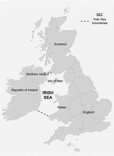
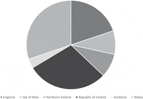
Figure 2. Number of Irish Sea MPAs, by country.
The Irish Sea covers an area of approximately 58,000 km2 and, while relatively shallow, has a maximum depth of 315 m in Beauforts Dyke in the North Channel (JNCC, Citation2004). Its geology and geographical location result in a rich biodiversity, distributed across the Irish Sea’s estuaries, cliffs, salt marshes, sand dunes, seabed and open sea. Species include sharks, harbour porpoises, spider crabs, dolphins, seals, sea bass, and various species of birds. Some species of birds, such as the arctic skua and the herring gull, are designated Red List species under the UK Birds of Conservation Concern review (The Wildlife Trusts Citation2017). In coastal habitats, species contribute to ecosystem functions through their biomass, and coastal degradation could result in the loss of dominant species, having a severe effect on coastal and marine ecosystem services (Lockwood and Maslo Citation2014). Threats to the Irish Sea’s coastal and marine ecosystems include fishing, terrestrial runoff, invasive species, oil spills, and climate change (JNCC Citation2004; Lockwood and Maslo Citation2014). The Irish Sea sees considerable traffic, as 80% of Ireland’s exports and imports pass through its ports, which handle about 7.6 megatonnes of trade annually with Great Britain (JNCC Citation2004; Aughey and Oakland Citation2013). Ferry services, cruise ships, and private vessels transport over 6 million people each year, the busiest port being Liverpool (Aughey and Oakland Citation2013).
The total human population residing within 10 km of the Irish Sea’s coastline is estimated at 6 million people, with its transport, commercial, and recreational activities employing upwards of 1.5 million people (JNCC Citation2004). Adequate conservation policies are required to protect the Irish Sea and the livelihoods that depend on it. MPAs may be considered the most effective tool against overexploitation, but there needs to be a balance between biological conservation and socioeconomic sustainability (Jameson et al. Citation2002; Pomeroy et al. Citation2005; Agardy et al. Citation2011). According to the World Database on Protected Areas (WDPA) and the Marine Conservation Institute’s MPAtlas, which both provide interactive and detailed maps of all MPAs worldwide, the Irish Sea boasts 198 designations across 112 MPA sites. These MPAs vary in their designations, from the national Sites of Special Scientific Interest (SSSIs) in the UK to the pan-European Natura 2000 network. These designations determine the status of conservation of each site ().
Table 1. Different types of protected area designations in the Irish Sea.
Designation and management of Irish Sea MPAs
Each country with a coastline on the Irish Sea has MPAs, with Wales and the Republic of Ireland designating the most sites (). The majority of MPAs in the Irish Sea are designated under the EU Birds and Habitats Directives. The implementation of the Birds and Habitats Directives when designating MPAs varies between countries. In the Republic of Ireland, MPAs are specifically designated for the protection of habitats and species in a way that some authors argue is more reactive than in the UK, with environmental protection generally implemented in response to current threats rather than to prevent future ones (Hynes et al. Citation2014; O’Higgins et al. Citation2019). The regulatory functions for activities within marine sites in the Republic of Ireland lie with the Aquaculture and Foreshore division of the Department of Aquaculture, Food and the Marine (DAFM) and the Department of Housing, Planning and Local Government, with the National Parks and Wildlife Service (NPWS), part of the Department of Culture, Heritage and the Gaeltacht, acting as a statutory consultant in relation to these regulatory activities. In the UK, environmental protection may be considered more proactive (O’Higgins et al. Citation2019). The UK’s marine environment is managed by an array of national and international legislation. MPAs result from the implementation of the 2009 Marine and Coastal Access Act (the Marine Act) in England and Wales, the 2010 Marine Act in Scotland, and the 2013 Marine Act in Northern Ireland. These Acts changed the framework for the management and protection of marine activities and resources, and each devolved administration is responsible for creating a protected area network in their own waters (Hawkins et al. Citation2016). In England, the management of MPAs falls under the responsibility of the Marine Management Organisation (MMO) and/or the local Inshore Fisheries and Conservation Authority (IFCA). Natural England is the non-departmental public body responsible for ensuring the protection of England’s marine environment and provides conservation advice to stakeholders and regulators. In Wales, marine management falls under the responsibility of Natural Resources Wales (NRW). Marine Scotland is responsible for the integrated management of MPAs in Scotland, while Northern Ireland’s Department of Agriculture, Environment and Rural Affairs (DAERA) sets out its marine management plans. The Isle of Man Government’s Department of Environment, Food and Agriculture is responsible for its MNRs.
Methods & materials
MPAs for this study were identified from data compiled by the UNEP and IUCN World Database on Protected Areas (WDPA). Considered ‘the most comprehensive global database on terrestrial and marine protected areas’ (IUCN Citation2017), it serves as a reference guide for protected area managers, policy makers, and conservationists. The WDPA (Citation2019) includes an MPA dataset, which was used to select Irish Sea sites for this study. A site is considered to be in the Irish Sea if it is located within the Irish Sea boundaries, outlined above. The list of sites was then cross-referenced with data from the Marine Conservation Institute’s MPAtlas, an ‘accurate and widely accepted tally of all MPAs’ (MCI Citation2019). This cross-referencing of data ensured that all Irish Sea MPAs were accounted for. Both the WDPA and MPAtlas provide general information on each site, including designation type, year of designation, area, governance type, and IUCN category.
Analyses of WDPA and MPAtlas datasheets found gaps in available data for many sites. This study aimed to identify and fill in these gaps, using publicly available data from management and advisory bodies. For each MPA designation, a list of conservation objectives, a management plan, and an environmental assessment were required for a site to be considered adequately managed. Conservation objectives are usually established during the designation phase of a protected area and specify ‘the overall target for the species and/or habitat types for which a site is designated in order for it to contribute to maintaining or reaching favourable conservation status’ (EC Citation2012). In addition to biophysical objectives, management plans were also analysed for any mention of socioeconomic factors such as whether stakeholders were involved in the governance and management of the site. In order to compile a more complete datasheet of Irish Sea MPAs, the appropriate authorities were contacted to provide missing information. Each organisation was asked whether the last online report was the most recent management document available for the specific site, whether more recent management plans were available offline or in preparation, and whether an ecological assessment had been conducted for key/target species (with a request for the findings, if yes).
Existing reports of environmental assessments conducted by the relevant authorities were used to determine the ecological effectiveness of Irish Sea MPAs. Across all Irish Sea sites, these assessments typically list the condition of each key species or habitats as ‘favourable’ or ‘unfavourable’. There may be further category levels to these two conditions. For example, a population decline in the range 1.0–24.9% in the Republic of Ireland is listed as ‘intermediate (unfavourable)’, while in England and Scotland, evaluators may rank an unfavourable condition as ‘unfavourable recovering,’ ‘no change,’ ‘declining,’ or ‘destroyed.’ For the purpose of this study, assessments were listed as either favourable (50% overall favourable condition and above) or unfavourable (49.9% and below). Assessments listed as ‘unfavourable (recovering condition)’ were considered unfavourable because the population has not yet fully recovered. The same consideration was applied to ratings of ‘unfavourable (no change),’ as key features are either not being conserved or are being lost (Natural England Citation2019). A site where target species or habitats had more ‘favourable’ features than ‘unfavourable’ ones was considered in overall favourable condition.
The NEOLI features were applied to Irish Sea MPAs to determine whether they could be used to explain why some Irish Sea MPAs are more effective than others. These were assessed in line with definitions by Edgar et al. (Citation2014): No-take (determined from the WDPA, MPAtlas, and management plans), Enforced (determined here by the existence of a management plan), Old (>10 years), Large (>100 km2), and Isolated (defined here as being removed from human activities).
Chi-square tests were performed to ascertain whether or not the relationships between two variables were significant (the different relationships include: the number of designations and the existence of a publicly available management plan; the number of designations and whether or not site assessments were conducted by the managing authorities; the number of designations and favourable assessment outcomes; and the number of sites with Natura 2000/OSPAR designations and the existence of management plans and monitoring). The p-values were all found to be p < 0.1. The Pearson correlation coefficient was used to measure the strength of any linear, bivariate associations. These statistical models helped illustrate the relationship between the number of designations an MPA has and whether or not it has a management plan and is monitored.
Results
A total of 112 MPAs were identified in the Irish Sea, distributed between England (23), Isle of Man (10), Northern Ireland (10), Republic of Ireland (34), Scotland (4) and Wales (35). Four sites are located in two countries: the North Channel (Northern Ireland and Scotland), Upper Solway Flats and Marshes (England and Scotland), Solway Firth (England and Scotland), and the Dee Estuary/Aber Dyfrdwy (England and Wales). Between them, these sites had 198 designations, 61 publicly available management plans and 49 available assessments of conservation outcomes.
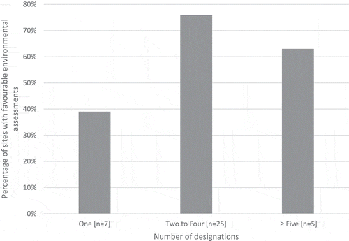
An analysis of the 198 designations () across the sites revealed a positive correlation (r = 0.6571; p < 0.01) between the number of designations of a site and the existence of a publicly available management plan (). Sites with a single designation were less likely to have a management plan: 39% of single-designation sites had management plans. The presence of a management plan was also linked to whether or not site assessments were conducted by the relevant authorities (r = 0.5924; p < 0.01). Having multiple designations is weakly correlated with favourable assessment outcomes (r = 0.3694; p < 0.01) (). Overall, 76% of sites with two or more designations were found to have management plans and 76% of these sites were found to be in overall favourable condition when assessed (66% of sites had available assessment results). In contrast, of the just 27% of single-designation sites which had been assessed, only 39% were considered in favourable condition.
Table 2. Number of sites with available conservation objectives, management plans, and environmental assessments, grouped by the number of designations a site has.
Figure 3. Relationship between the number of MPA designations and the existence of a publicly available management plan.
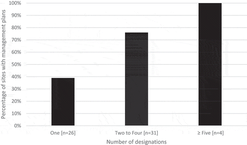
Figure 4. Relationship between the number of MPA designations and favourable environmental assessment results.
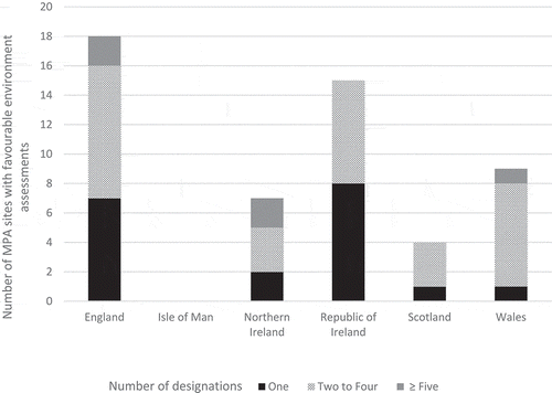
In a country-by-country analysis ( and ), only two management plans were found for the 22 single-designation sites in the Republic of Ireland and two were found for its 12 multiple-designation sites (). However, almost all sites had conservation objectives and 15 had been assessed: 13% in favourable condition for single-designation sites and 50% for multiple-designation sites. The UK () has management plans for most of its sites, although a third of single-designation sites lack management plans and only 31% have been assessed. The majority (96%) of UK sites with two to four designations (28 sites) had management plans and had been assessed (71%), while the four sites with five or more designations were all found to have management plans and been evaluated. Broken down by individual country within the UK, two of Northern Ireland’s three single-designation sites had management plans and had been assessed, with one of these sites being considered in favourable condition. Northern Ireland’s seven multiple-designation sites all had management plans, with 71% being evaluated and 83% of these were considered in favourable condition. All four Scottish sites had management plans, and all had been evaluated, with all but one site considered in overall favourable condition. In Wales, 20 out of its 24 single-designation sites were found to have management plans, but only one site had been assessed and was found to be in favourable condition. Of the multiple-designation sites (11 sites), all had management plans and eight had been assessed, with the majority (80%) considered in overall favourable condition. In England, only two of the nine single-designation MPAs had management plans, but seven sites had been evaluated, with 57% of sites being considered overall favourable. In England’s multiple-designation sites (14 sites), 13 management plans were found and 11 had been assessed, with 88% of sites considered in overall favourable condition. On the Isle of Man (), only Ramsey Bay had an individual management plan, but no assessment was found.
Table 3. REPUBLIC OF IRELAND: Number of sites with available conservation objectives, management plans, and environmental assessments, grouped by the number of designations a site has.
Table 4. UNITED KINGDOM: Number of sites with available conservation objectives, management plans, and environmental assessments, grouped by the number of designations a site has.
Table 5. ISLE OF MAN: Number of sites with available conservation objectives, management plans, and environmental assessments, grouped by the number of designations a site has.
Figure 5. Relationship between the number of MPA designations and the existence of a publicly available management plan, by country.
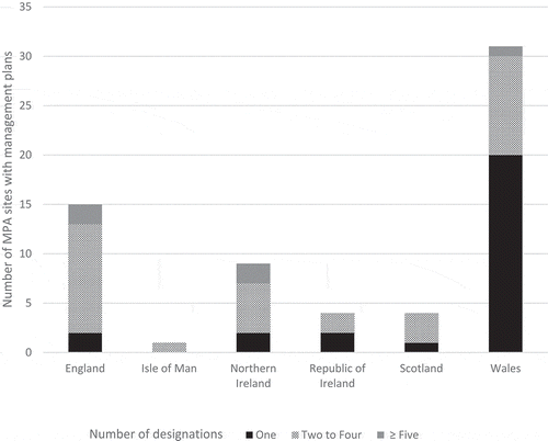
Figure 6. Relationship between the number of MPA designations and favourable environmental assessment results, by country.
Applying the NEOLI factors to Irish Sea MPAs revealed that none of the sites could fulfil the minimum of four out of five criteria suggested for successful MPAs. None of the Irish Sea MPAs are no-take, despite some being designated marine reserves, which are generally no-take zones and prohibit any form of extraction from the site (e.g. fishing). Irish Sea MPAs range in size from 0.23 km2 (Coedydd Afon Menai) to 7,376 km2 (West Wales Marine/Gorllewin Cymru Forol). A total of 25 sites are greater than 100 km2, with 14 of them having multiple designations. Of these large sites, 19 have management plans and 86% were considered in favourable condition. The Irish Sea being a busy waterway and, because it lacks no-take zones, its MPAs are not isolated. Most sites (65%) have a coastal component and even offshore sites are subjected to anthropogenic pressures. The Irish Sea Front SPA, 180 km2 in area and located halfway between Anglesey in Wales and County Down in Northern Ireland, is under pressure from fishing activity, shipping, and energy generation.
Most sites were first designated in the mid- to late-90s (the majority in 1996 and 1999); subsequent designations occurred in the last 10 years (2010, 2018). Sites are designated before a management plan is developed, so some of the newer sites may be in the process of implementing management plans over the next few years.
There is a weak positive correlation between whether a site is part of the Natura 2000 and/or OSPAR networks and the existence of management plans and monitoring (r = 0.2731; r = 0.4693; p < 0.01). Most Irish Sea MPAs became part of the ecologically coherent OSPAR network of MPAs during the last decade. Where assessments had been done, it was determined that 63% of sites were in favourable condition since the OSPAR designation. Of the thirty-two designated sites, thirty of them have management plans while twenty-five have been assessed (78%). This is close to OSPAR’s overall findings: in 2016, 60% of OSPAR sites were at least partially monitored and 77% had partially or fully documented management plans (OSPAR Citation2016).
In relation to socioeconomic issues, only 45 of the 112 sites (or 74 of 198 designations) mentioned in their management plans or conservation objectives how an MPA would affect surrounding communities and users and/or provided advice on how to manage any issues that may arise between stakeholders. For most other sites, reports simply described how anthropogenic pressures (e.g. fishing, land use, horse-riding, SCUBA diving, dog-walking, etc.) affected target species or habitats.
Discussion
The results of this study show that multiple designations appear to have a positive effect on the biological conservation outcomes of MPAs, but many sites are missing management plans and/or have not been assessed. These sites could be considered paper parks. Both Natura 2000 and OSPAR designations are legally-binding (OSPAR Citation2003; EC 2017), which may explain why these types of sites have more management plans than sites with only national designations. Sites/Areas of Special Scientific Interest (SSSIs or ASSIs) in the UK have no legal requirement for a management plan to be in place. These SSSIs may also be managed as part of a framework for a site’s designation under the Birds and Habitats Directives. For example, the management plan for Anglesey Terns/Morwenoliaid Ynys Môn SPA (previously known as Ynys Feurig, Cemlyn Bay and The Skerries SPA, in Anglesey, Wales) is applicable to Cemlyn Bay SAC, Ynys Feurig SSSI, The Skerries SSSI, and Cemlyn Bay SSSI. Sites that are part of the Ramsar Convention for Wetlands have usually been designated under the EU Birds and Habitats Directives, such as North Bull Island (County Dublin, Republic of Ireland) or Morecambe Bay (Lancashire, England).
The Birds and Habitats Directives require that conservation objectives and measures be set to determine the type of management necessary ‘to ensure that the species and habitat types they protect are maintained, or restored, to a favourable conservation status throughout their natural range within the EU’ (EC Citation2014). Management plans are not obligatory, but are recommended, which may explain why 96% of all sites have set conservation objectives, but only 54% have prepared management plans. Reports should be produced every six years for the European Commission to monitor the progress made at each site, but whether these reports contain ecological assessments remains unclear. When assessing the condition of most Irish Sea sites, it was difficult to ascertain whether an additional designation has had a positive effect on the ecological condition of an MPA because, in most cases, there is no baseline data against which to compare the current state of an MPA.
The proportion of sites with management plans in the Irish Sea overall is brought down by the lack of management plans in the Republic of Ireland and on the Isle of Man. According to the NPWS, part of Ireland’s Department of Culture, Heritage and the Gaeltacht, no conservation management plans are being developed for Natura 2000 marine sites. Instead, city councils may opt to prepare a management plan for their MPAs: Dublin City Council developed North Bull Island’s management plan, while Fingal County Council prepared a management plan for Ireland’s Eye. The main regulatory functions for activities within marine sites fall under the authority of the Aquaculture and Foreshore division of the Department of Aquaculture, Food and the Marine and the Department of Housing, Planning and Local Government. Most of the Isle of Man’s MNRs were designated in late 2018 and management plans are being developed. The Manx government’s Department of Environment, Food and Agriculture has established a stakeholder group to develop considerations for the management of these sites in addition to the current conservation objectives.
This study found that only 43% of sites have had any kind of assessment, even though effective management of MPAs requires not only the existence of management plans but also regular assessments to determine if conservation objectives have been met (Pomeroy et al. Citation2005; Cook et al. Citation2010). Addison et al. (Citation2015) even suggest that evaluations should be conducted annually instead of the current norm of every 5–10 years. This lack of assessments in the Irish Sea confirms findings from Australia (Cook et al. Citation2010) where 60% of practitioners were found to rely on experience rather than assessments to support their management decisions. While managers’ judgements of on-ground conditions can be highly accurate and their judgements should not be disregarded as they provide valuable qualitative data (Cook et al. Citation2014), differences in interpretation by managers of what can be described as ‘good’ conditions may compromise this accuracy and make the reproducibility of assessments difficult (Addison et al. Citation2015).
To support sustainable development objectives, the integration of social sciences and ecological research should be a priority for successful biological conservation (Dearing et al. Citation2012), but researchers tend to divide systems into ‘natural’ and ‘human’ components and study them separately (Redman et al. Citation2004; Ostrom Citation2009; Ban et al. Citation2013). Interactions between both ecological and social factors need to be studied to be able to identify the opportunities and barriers facing effective conservation policy implementation (Guerrero and Wilson Citation2017). Ecosystems, such as those protected by MPAs, provide a wide array of services that are necessary for human survival, in terms of health, emotional wellness, or economics (MEA Citation2005; Costanza et al. Citation2014). This study found that less than half of all Irish Sea MPAs considered socioeconomic issues in their conservation objectives or management plans. Yet most Irish Sea MPAs are part of the Natura 2000 network and should therefore be managed so as ‘not to exclude socioeconomic activities […] but rather to find ways for these to operate in a way that also safeguards and supports the valuable species and habitats present, and maintains the overall health of natural ecosystems for the benefit of society as a whole’ (EC Citation2014). This echoes Aichi Target 11’s aim of ensuring equitable management of protected areas. However, MPA networks, particularly in England, focus more on biodiversity conservation and the protection of rare or threatened species than on protecting ecosystem services, but Potts et al. (Citation2014) argue that emphasis should be placed on biodiversity, functioning and resilience, rather than simply focus on a few key features. Indeed, MPAs provide other benefits than simply biodiversity conservation, which should be taken into consideration when one assesses the overall effectiveness of MPAs, due not only to their contribution to ecosystem health but to human well-being as well (Bennett and Dearden Citation2014; Jobstvogt et al. Citation2014; Rees et al. Citation2015). Wales and Scotland have taken a more holistic and sustainable approach to conservation, with the Welsh government proposing an increase in protection of existing MPAs to focus on the protection of biodiversity, functioning, and resilience, and the Scottish government promoting the delivery and functioning of ecosystem services within the context of nature conservation and sustainable development (Potts et al. Citation2014).
The results of this study are limited by the accessibility to management plans and site assessments, if they exist at all. Even where long-term biological monitoring exists, Addison et al. (Citation2015) find that it is frequently not used by protected area managers. This seems to be because it is difficult for many site managers to access relevant information to support their decisions (Pullin and Knight Citation2005; Addison et al. Citation2015, Citation2017). The complex governance of MPAs in the Irish Sea – with many different authorities often overseeing a single site – can make access to information difficult. When looking into several English MPAs where data was missing, there was confusion between the various authorities that oversee governance of the marine environment in England: the MMO, the local IFCA, and Natural England. When Natural England was contacted regarding missing data for English MPAs, they suggested we contact the MMO, who referred us to the IFCA, who in turn explained that the missing data could be found by contacting Natural England. In the Republic of Ireland, three different departments govern MPAs, with county councils also playing a role in their management. This can make effective management difficult. While multiple designations can potentially make MPAs more sustainable by improving the resilience of protected areas to external pressures, increasing public awareness, and reinforcing or creating conservation partnerships, they can make the management of a protected area challenging when different national authorities oversee one area (Schaaf and Clamote Rodrigues Citation2016).
Conclusion
The NEOLI features being insufficient to determine the effectiveness of MPAs in busy waterways, looking at multiple designations may be an alternative approach. The results of this study show that the more designations a site has, the more likely it is to be effectively managed (i.e. have an existing management plan and present favourable conservation outcomes). Single-designation sites tended to lack a clear management plan and, where site assessments existed, were generally in unfavourable condition. This is perhaps because SSSIs in the UK are not legally-binding and SACs and SPAs under the EU Birds and Habitats Directives do not require a management plan. More research is needed to really understand why having multiple designations is linked to improved conservation outcomes. Do sites with multiple designations benefit from better human and financial resources, leading to more effective management, or is the reverse true, namely that better managed sites are more likely to obtain multiple designations?
Although MPAs are only successful if they achieve their biological conservation goals while also protecting socioeconomic interests (Pomeroy et al. Citation2005; Claudet Citation2011), this study found that few sites had management plans or conservation objectives that addressed their socioeconomic impacts. It is possible that MPA managers do engage with local stakeholders more than is captured in available management plans and predominantly biological assessments. Qualitative research with MPA managers could help to explore this issue further.
The fact that multiple designations appear to be beneficial highlights the wider importance of understanding the requirements of national, regional and international-level conservation designations and how they interact with each other. This is of particular relevance in the current debate about Brexit. Since the first Environmental Programme of the early 1970s, the EU has had one of the most comprehensive and influential set of environmental policies in the world, and the UK has been a key player in the formation of these policies since it joined the European Economic Community on 1 January 1973 (Boyes and Elliott Citation2016). If the UK leaves the EU, but decides to stay within the internal market through European Economic Area (EEA) membership by joining the European Free Trade Association (EFTA), ‘the UK would be expected to adopt the full body of EU laws, but without the power and opportunity to influence EU-decision making’ (Boyes and Elliott Citation2016). The Habitats and Birds Directives are not included in the EEA Agreement. If the UK decides to completely remove itself from all European agreements, it will nevertheless remain a signatory to international agreements, such as the OSPAR Convention and the Convention on Biological Diversity and will continue to have to meet those commitments. Given that the OSPAR requirements are similar to the EU’s, this may ensure continued regional cooperation for marine protection (O’Higgins et al. Citation2019). All EU regulations currently protecting the environment, such as the Natura 2000 network, would likely be repealed once Brexit is delivered, and would need to be reintegrated back into the UK legal system (Kirkham and Shepherd Citation2016). This can make the future uncertain for UK MPAs. The outcomes of this study show that not all Irish Sea MPAs are paper parks and that the more designations a site has, the less likely it is to be a paper park. Designations such as the Birds and Habitats Directives play a role in the ecological effectiveness of MPAs, suggesting that these policies should remain in force to ensure successful marine conservation in the Irish Sea.
Acknowledgments
This work was supported by the Economic and Social Research Council [ES/P000703/1]. The authors would like to thank, in no particular order, the Department of Culture, Heritage and the Gaeltacht (Republic of Ireland); the Department of Environment, Food and Agriculture (Isle of Man); Natural Resources Wales; the Cheshire, the Greater Manchester, Merseyside & Lancashire Area Team of Natural England; the Marine Management Organisation (MMO); the North Western Inshore Fisheries and Conservation Authority (England); Fingal County Council (Republic of Ireland); and the Royal Society for the Protection of Birds (UK) for their help in filling in the missing data.
Disclosure statement
No potential conflict of interest was reported by the authors.
Additional information
Funding
References
- Abesamis RA, Russ GR. 2005. Density‐dependent spillover from a marine reserve: long-term evidence. Ecol Appl. 15(5):1798–1812.
- Addison PFE, Flander LB, Cook CN. 2015. Are we missing the boat? Current uses of long-term biological monitoring data in the evaluation and management of marine protected areas. J Environ Manage. 149:148–156.
- Addison PFE, Flander LB, Cook CN. 2017. Towards quantitative condition assessment of biodiversity outcomes: insights from Australian marine protected areas. J Environ Manage. 198:183–191.
- Álvarez-Fernández I, Fernández N, Sánchez-Carneroc N, Freire J. 2017. The management performance of marine protected areas in the North-east Atlantic Ocean. Mar Policy. 76:159–168.
- Agardy T, Notarbartolo Di Sciara G, Christie P. 2011. Mind the gap: addressing the shortcomings of marine protected areas through large scale marine spatial planning. Mar Policy. 35:226–232.
- Amengual J, Alvarez-Berastegui D. 2018. A critical evaluation of the aichi biodiversity target 11 and the mediterranean MPA network, two years ahead of its deadline. Biol Conserv. 225:187–196.
- Aughey A, Oakland J. 2013. Irish civilisation: an introduction. Oxford (UK): Routledge.
- Ban NC, Davies TE, Aguilera SE, Brooks C, Cox M, Epstein G, Evans L, Maxwell SM, Nenadovich M. 2017. Social and ecological effectiveness of large marine protected areas. Global Environ Chang. 43:82–91.
- Ban NC, Mills M, Tam J, Hicks CC, Klain S, Stoeckl N, McKinnon M, Levine J, Pressey R, Satterfield T, et al. 2013. A social-ecological approach to conservation planning: embedding social considerations. Front Ecol Environ. 11(4):194–202.
- Bennett NJ, Dearden P. 2014. From measuring outcomes to providing inputs: governance, management, and local development for more effective marine protected areas. Mar Policy. 50:96–110.
- Blicharska M, Roberge JM, Grodzinska-Jurczak M. 2016. Contribution of social science to large scale biodiversity conservation: A review of research about the Natura 2000 network. Biol Conserv. 199:110–122.
- Boyes SJ, Elliott M. 2016. Brexit: the marine governance horrendogram just got more horrendous! Mar Pollut Bull. 111(1):41–44.
- Briggs J, Baez SK, Dawson T, Golder B, O’Leary BC, Petit J, Roberts CM, Rogers A, Villagomez A 2018. Recommendations to IUCN to improve marine protected area classification and reporting. The Pew Charitable Trusts. [accessed 2019 Oct 8]. http://www.pewtrusts.org/~/media/assets/2018/02/cp_how_much_of_the_ocean_is_really_protected.pdf.
- Cardinale BJ, Duffy E, Gonzales A, Hooper DU, Perrings C, Venail P, Narwani A, Mace GM, Tilman D, Wardle DA, et al. 2012. Biodiversity loss and its impact on humanity. Nature. 486(7401):59–67.
- [CBD] Convention on Biological Diversity. 2010. Decision Adopted by the Conference of the Parties to the Convention on Biological Diversity at its Tenth Meeting. [accessed 2019 Jan 25]. https://www.cbd.int/doc/decisions/cop-10/cop-10-dec-02-en.pdf.
- [CBD] Convention on Biological Diversity. 2017. Background note in the form of questions and answers “Global marine protected area target of 10% to be achieved by 2020”. [accessed 2019 Jan 25]. https://www.cbd.int/pa/UN-Ocean-Conference/faq-en.pdf.
- [CEC] Council of European Communities. 1992. Council directive 92/43/EEC of 21 May 1992 on the conservation of natural habitats and of wild fauna and flora. [accessed 2019 Aug 16]. https://eur-lex.europa.eu/legal-content/EN/TXT/HTML/?uri=CELEX:31992L0043&from=en.
- Christie P, Pollnac R. 2011. SOCIO-ECONOMY – social dynamics of scaling-up marine protected area declarations and management. In: Claudet J, editor. Marine protected areas: a multidisciplinary approach. Cambridge (UK): Cambridge University Press (Ecology, Biodiversity and Conservation); p. 121–140.
- Claudet J. 2011. Introduction. In: Claudet J, editor. Marine protected areas: a multidisciplinary approach. Cambridge (UK): Cambridge University Press (Ecology, Biodiversity and Conservation); p. 1–8.
- Cook CN, Carter RW, Hockings M. 2014. Measuring the accuracy of management effectiveness evaluations of protected areas. J Environ Manage. 139:164–171.
- Cook CN, Hockings M, Carter RW. 2010. Conservation in the dark? The information used to support management decisions. Front Ecol Environ. 8(4):181–186.
- Costanza R, Groot R, Sutton P, Van der Ploeg S, Anderson S, Kubiszewski I, Farber S, Turner R. 2014. Changes in the global value of ecosystem services. Global Environ Chang. 26:152–158.
- Costello MJ, Ballantine B. 2015. Biodiversity conservation should focus on no-take marine reserves – 94% of marine protected areas allow fishing. Trends Ecol Evol. 30(9):507–509.
- Dearing JA, Bullock S, Costanza R, Dawson TP, Edwards ME, Poppy GM, Smith GM. 2012. Navigating the perfect storm: research strategies for socio-ecological systems in a rapidly evolving world. Environ Manage. 49:767–775.
- [DEFRA] Department for Environmental, Food, and Rural Affairs. 2019. Marine strategy part one: UK updated assessment and good environmental status. [accessed 2019 Sept 24]. https://consult.defra.gov.uk/marine/updated-uk-marine-strategy-part-one/supporting_documents/UKmarinestrategypart1consultdocumentfinal.pdf.
- [EC] European Commission. 2008. Directive 2008/56/EC of the European parliament and of the European council of 17 June 2008 establishing a framework for community action in the field of marine environmental policy (marine strategy framework directive). [accessed 2019 Sept 24]. https://eur-lex.europa.eu/legal-content/EN/TXT/HTML/?uri=CELEX:32008L0056&from=EN.
- [EC] European Commission. 2009. Directive 2009/147/EC of the European parliament and of the European council of 30 November 2009 on the conservation of wild birds. [accessed 2019 Aug 16]. https://eur-lex.europa.eu/legal-content/EN/TXT/HTML/?uri=CELEX:32009L0147&from=EN.
- [EC] European Commission. 2012. Commission note on setting conservation objectives for natura 2000 sites. [accessed 2019 Oct 16]. https://ec.europa.eu/environment/nature/natura2000/management/docs/commission_note/commission_note2_EN.pdf.
- [EC] European Commission. 2014. The EU birds and habitats directives. [accessed 2019 Aug 11]. https://ec.europa.eu/environment/nature/info/pubs/docs/brochures/nat2000/en.pdf.
- [EC] European Commission. 2019. Natura 2000. [accessed 2019 Aug 16]. https://ec.europa.eu/environment/nature/natura2000/index_en.htm. [IHO] International Hydrographic Organisation. 1953. Limits of oceans and seas. [accessed 2017 Oct 13]. http://www.iho.int/iho_pubs/standard/S-23/S-23_Ed3_1953_EN.pdf.
- Edgar GJ. 2011. Does the global network of marine protected areas provide an adequate safety net for marine biodiversity? Aquat Conserv. 21:313–316.
- Edgar GJ, Stuart-Smith RD, Willis TJ, Kininmonth S, Baker SC, Banks S, Barrett NS, Becerro MA, Bernard ATF, Berkhout J, et al. 2014. Global conservation outcomes depend on marine protected areas with five key features. Nature. 506:216–220.
- Ehler CN. 2003. Indicators to measure governance performance in integrated coastal management. Ocean Coast Manage. 46:335–345.
- Fraschetti S, Claudet J, Grorud-Colvert K. 2011. MANAGEMENT – transitioning from single-sector management to ecosystem-based management: what can marine protected areas offer? In: Claudet J, editor. Marine protected areas: a multidisciplinary approach. Cambridge (UK): Cambridge University Press (Ecology, Biodiversity and Conservation); p. 11–34.
- Gallacher J, Simmonds N, Fellowes H, Brown N, Gill N, Clark W, Biggs C, Rodwell LD. 2016. Evaluating the success of a marine protected area: A systematic review approach. J Environ Manage. 183:280–293.
- Gill D, Mascia MB, Ahmadia GN, Glew L, Lester SE, Barnes M, Craigie I, Darling ES, Free CM, Geldmann J, et al. 2017. Capacity shortfalls hinder the performance of marine protected areas globally. Nature. 543(7647):665–669.
- Guerrero AM, Wilson KA. 2017. Using a social–ecological framework to inform the implementation of conservation plans. Conserv Biol. 31(2):290–301.
- Halpern BS. 2014. Making marine protected areas work. Nature. 506(7487):167–168.
- Halpern BS, Walbridge S, Selkoe KA, Kappel CV, Micheli F, D’Agrosa C, Bruno JF, Casey KS, Ebert C, Fox HE, et al. 2008. A global map of human impact on marine ecosystems. Science. 319(5865):948–952.
- Hausner VH, Engen S, Bludd EK, Yoccoz NG. 2017. Policy indicators for use in impact evaluations of protected area networks. Ecol Indic. 75:192–202.
- Hawkins JP, O’Leary BC, Bassett N, Peters H, Rakowski S, Reeve G, Roberts CM. 2016. Public awareness and attitudes towards marine protection in the United Kingdom. Mar Pollut Bull. 111:231–236.
- Hynes S, Norton D, Corless R. 2014. Investigating societal attitudes towards the marine environment of Ireland Stephen. Mar Policy. 47:57–65.
- [IUCN] International Union for Conservation of Nature. 2017. World database on protected areas (WDPA). [accessed 2019 Aug 16]. https://www.iucn.org/theme/protected-areas/our-work/quality-and-effectiveness/world-database-protected-areas-wdpa.
- Jameson SC, Tupper MH, Ridley JM. 2002. The three screen doors: can marine “protected” areas be effective? Mar Pollut Bull. 44:1177–1183.
- [JNCC] Joint Nature Conservation Committee. 2004. The Irish Sea pilot. [accessed 2017 Aug 18]. http://jncc.defra.gov.uk/pdf/irishseapilot_all.pdf.
- [JNCC] Joint Nature Conservation Committee. 2010. Different types of marine protected area. [accessed 2017 Aug 22]. http://jncc.defra.gov.uk/pdf/MPAsInfoDoc_v2_2.pdf.
- Jobstvogt N, Watson V, Kenter JO. 2014. Looking below the surface: the cultural ecosystem service values of UK marine protected areas (MPAs). Ecosyst Serv. 10:97–110.
- Kirkham K, Shepherd P. 2016. Natura 2000 post brexit in the UK — challenges and opportunities? Habitat Reg Assess J. 7:16–19.
- Klein CJ, Brown CJ, Halpern BS, Segan DB, McGowan J, Watson JEM. 2015. Shortfalls in the global protected area network at representing marine biodiversity. Sci Rep. 5:1–7.
- Leleu K, Alban F, Pelletier D, Charbonnel E, Letourneur Y, Boudouresque CF. 2012. Fishers’ perceptions as indicators of the performance of marine protected areas (MPAs). Mar Policy. 36:414–422.
- Leverington F, Lemos Costa K, Pavese H, Lisle A, Hockings M. 2010. A global analysis of protected area management effectiveness. Environ Manage. 46:685–698.
- Levine AS, Richmond L, Lopez-Carr D. 2015. Marine resource management: culture, livelihoods, and governance. Appl Geog. 59:56–59.
- Lockwood JL, Maslo B. 2014. The conservation of coastal biodiversity. In: Lockwood JL, Maslo B, editors. Coastal conservation. Cambridge (UK): Cambridge University Press; p. 1–12.
- Long RD, Charles A, Stephenson RL. 2015. Key principles of marine ecosystem-based management. Mar Policy. 57:53–60.
- Lopes R, Videira N. 2013. Valuing marine and coastal ecosystem services: an integrated participatory framework. Ocean Coast Manage. 84:153–162.
- [MCI] Marine Conservation Institute. 2019. MPAtlas: atlas of marine protection. [accessed 2019 Aug 16]. http://www.mpatlas.org/.
- [MEA] Millennium Ecosystem Assessment. 2005. Ecosystems and human well-being: synthesis. [accessed 2019 Jul 3]. https://www.millenniumassessment.org/documents/document.356.aspx.pdf.
- Morgan R. 2013. Exploring how fishermen respond to the challenges facing the fishing industry: a study of diversification and multiple-job holding in the English channel fishery [dissertation]. Portsmouth (UK): University of Portsmouth.
- [NPWS] National Parks & Wildlife Service. 2018. Marine habitats. [accessed 2018 Oct 11]. https://www.npws.ie/marine/marine-habitats.
- Moser D, Ellmauer T, Evans D, Zulka KP, Adam M, Dullinger S, Essl F. 2016. Weak agreement between the species conservation status assessments of the European habitats directive and red lists. Biol Conserv. 198:1–8.
- Natural England. 2019. SSSI glossary. [accessed 2018 Oct 28]. https://designatedsites.naturalengland.org.uk/SSSIGlossary.aspx.
- Nikitine J, Wilson M, Dawson TP. 2018. Developing a framework for the efficient design and management of large scale marine protected areas. Mar Policy. 94:196–203.
- Nils LJ, Dey AD, Maslo B. 2014. Overexploitation of marine species and its consequences for terrestrial biodiversity along coasts. In: Maslo B, Lockwood JL, editors. Coastal conservation. Cambridge (UK): Cambridge University Press; p. 347–367.
- O’Higgins T, O’Higgins L, O’Hagan AM, Onwona Ansong J. 2019. Challenges and opportunities for ecosystem-based management and marine spatial planning in the Irish Sea. In: Zaucha J, Gee K, editors. Marine spatial planning: past, present, future. Basingstoke (UK): Palgrave Macmillan; p. 48–70.
- O’Leary B, Winther-Janson M, Bainbridge J, Aitken J, Hawkins JP, Roberts CM. 2016. Effective coverage targets for ocean protection. Conserv Lett. 9(6):398–404.
- [OECD] Organisation for Economic Co-operation and Development. 2016. Marine protected areas: economics, management and effective policy mixes – policy highlights. [accessed 2019 Aug 16]. https://www.oecd.org/env/marine-protected-areas-9789264276208-en.htm.
- Orlikowska E, Roberge J, Blicharska M, Mikusiński G. 2016. Gaps in ecological research on the world’s largest internationally coordinated network of protected areas: a review of natura 2000. Biol Conserv. 200:216–227.
- OSPAR Commission. 2003. OSPAR recommendation 2003/3 on a network of marine protected areas. [accessed 2018 Oct 11]. http://www.ospar.org/documents?d=32867.
- OSPAR Commission. 2016. Summary status of the OSPAR network of marine protected areas (2016). [accessed 2019 Sept 3]. https://oap.ospar.org/en/ospar-assessments/intermediate-assessment-2017/biodiversity-status/marine-protected-areas/.
- Ostrom E. 2009. A general framework for analyzing sustainability of social-ecological systems. Science. 325:419–422.
- Pomeroy RS, Watson LM, Parks JE, Cid GA. 2005. How is your MPA doing? A methodology for evaluating the management effectiveness of marine protected areas. Ocean Coast Manage. 48:485–502.
- Potts T, Burdon D, Jackson E, Atkins J, Saunders J, Hastings E, Langmead O. 2014. Do marine protected areas deliver flows of ecosystem services to support human welfare? Mar Policy. 44:139–148.
- Pullin AS, Knight TM. 2005. Assessing conservation management’s evidence base: A survey of management-plan compilers in the United Kingdom and Australia. Conserv Biol. 19(6):1989–1996.
- Ramsar. 2014. The ramsar sites. [accessed 2017 Aug 3]. http://www.ramsar.org/sites-countries/the-ramsar-sites.
- Redman CL, Grove JM, Kuby LH. 2004. Integrating social science into the long-term ecological research (LTER) network: social dimensions of ecological change and ecological dimensions of social change. Ecosystems. 7:161–171.
- Rees SE, Mangi SC, Hattam C, Gall SC, Rodwell LD, Peckett FJ, Attrill MJ. 2015. The socio-economic effects of a marine protected area on the ecosystem service of leisure and recreation. Mar Policy. 62:144–152.
- Rodríguez-Rodríguez D, Rees S, Mannaerts G, Sciberras M, Pirie C, Black G, Aulert C, Sheehan EV, Carrier S, Attrill MJ. 2015a. Status of the marine protected area network across the English channel (La Manche): cross-country similarities and differences in MPA designation, management and monitoring. Mar Policy. 51:536.
- Rodríguez-Rodríguez D, Sciberras M, Foster NL, Attrill MJ. 2015b. Status of management effort in 153 marine protected areas across the English channel. Mar Pollut Bull. 94:168–175.
- Sala E, Lubchenco L, Grorud-Colvert K, Novelli C, Roberts C, Sumaila UR. 2018. Assessing real progress towards effective ocean protection. Mar Policy. 91:11–13.
- Sanderson EW, Jaiteh M, Levy MA, Redford KH, Wannebo AV, Woolmer G. 2002. The human footprint and the last of the wild. Bioscience. 52:891–904.
- Schaaf T, Clamote Rodrigues D. 2016. Managing MIDAs: harmonising the management of multi- internationally designated areas: ramsar sites, world heritage sites, biosphere reserves and UNESCO global geoparks. Gland (Switzerland): IUCN; p. xvi- 140.
- Schreckenberg K, Franks P, Martin A, Lang B. 2016. Unpacking equity for protected area conservation. Parks. 22(2):11–26.
- Soler G, Edgar GJ, Russell Thomson R, Kininmonth S, Campbell SJ, Dawson TP, Barrett N, Bernard A, Galvan D, Willis T, et al. 2015. Reef fishes at all trophic levels respond positively to effective marine protected areas. PLoS One. 10(10):1–12.
- The Wildlife Trusts. 2017. The Irish Sea - species A to Z. [accessed 2017 Oct 10]. http://www.irishsea.org/wildlife/species-a-z.
- UK MPA Centre. 2007. A history of marine protected areas in the UK. [accessed 2018 Oct 12] http://www.ukmpas.org/documents/history_topic_note.pdf.
- UNEP-WCMC, IUCN and NGS. 2018. Protected Planet Report 2018. Cambridge UK; Gland (Switzerland; and Washington, D.C., USA): UNEP-WCMC, IUCN and NGS.
- [UNESCO] United Nations Educational, Scientific and Cultural Organisation. 2017. Biosphere reserves – learning sites for sustainable development. [accessed 2017 Aug 3]. http://www.unesco.org/new/en/natural-sciences/environment/ecological-sciences/biosphere-reserves/.
- Walther GR, Post E, Convey P, Menzel A, Parmesan C, Beebee TJC, Fromentin JM, Hoegh-Guldberg O, Bairlein F. 2002. Ecological responses to recent climate change. Nature. 416:389–395.
- [WDPA] World Database on Protected Areas. 2019. Protected planet. [accessed 2019 Jan 17]. https://www.protectedplanet.net/.
- Wells S, Carleton Ray G, Gjdrde KM, White AT, Muthiga N, Bezaury Creel JE, Causey BD, McCormick-Ray J, Salm R, Gubbay S, et al. 2016. Building the future of MPAs – lessons from history. Aquat Conserv. 26(2):101–125.
- [WWF] World Wildlife Fund. 2005. An overview of marine protected areas in the UK. [accessed 2018 Oct 12]. http://assets.wwf.org.uk/downloads/ma_overviewukmpa.pdf.