
Abstract
A decision support tool aiming to facilitate discussion and transparency in land-use planning processes has been developed. It includes process steps initiating with an analysis of the current situation, identification of relevant actions and sustainability analysis steps. The sustainability was subdivided into human health and environment, resources, and social and economic impacts. The main difference between this risk analysis tool and others is the allowance of comparisons of present risks and consequences of measures early in the process. It also includes assessments from short- and long-term perspectives, such as taking into account climate change. It combines classic risk analysis with life-cycle assessment procedure. It has been developed and tested in co-operation with municipalities. The tests show that the tool is applicable and can be relevant in the planning process. It offers an iterative discussion framework that is systematic, condensed and yet a simplistic way of describing consequences. The criticism is that it is regarded as time demanding, but this can be managed by preparatory work.
Introduction
Sustainability describes the ability to go on for a long time (Hansson Citation2010). It is regarded as a crucial part of physical planning (Dempsey et al. Citation2011). The most common definition of a sustainable development is a development that meets present needs while still allowing for future generations to fulfil their needs (Brundtland Citation1987). It involves social, economic and environmental dimensions. Sustainable living areas need to provide a good quality of living and environmental quality (Dempsey et al. Citation2012), both in present time and in the future. To meet demands for a change towards a sustainable society measures have been taken. Examples on global and European levels are directives and agreements (EC Citation1907/Citation2006, UN-ECE Citation1991, Citation2000/Citation60/EC, UNFCC Citation2009). Measures have also been taken on national levels. For example in Sweden national environmental quality objectives have been set (Miljömålsrådet Citation2008). The implementation of environmental objectives and to incorporate sustainability considerations in general in the spatial planning decision process has, however, been problematic both in Sweden and internationally (Johansson Citation2008). A contributing factor is that there is no consensus on how to define, or achieve, a sustainable development (Pacione Citation2003, Chiesura Citation2004, Fahy and Ó Cinnéide Citation2008, Dempsey et al. Citation2011). Instead economic aspects are often in focus (Pacione Citation2003, Chiesura Citation2004, Fahy and Ó Cinnéide Citation2008, Keirstead and Leach Citation2008).
As a consequence, solutions that are most optimal over a long time and/or from a sustainability perspective are often not implemented (Roth Citation2005, Johansson Citation2008, Glaas et al. Citation2010).
A holistic sustainability assessment should preferably include economic, environmental and social aspects on different impact levels ranging from the material or site-specific level to the system level via the local semi-regional or the so-called narrow life-cycle level (Roth and Eklund Citation2003). An important question in such an analysis is how different aspects and different levels should be assessed and valued (Hansson Citation2010, Edvardsson Björnberg and Hansson Citation2011). Often at the local level, for example in local flood risk management, large efforts are made on local-scale risk assessment while social and larger-scale environmental impacts are regarded as abstract, hard to estimate in relation to the impacts and therefore often omitted (Johansson Citation2008, Glaas et al. Citation2010). On the contrary, on the international and national political agenda, sustainability is usually assessed using tools developed for those purposes, e.g. carbon foot print analyses (PAS Citation2050 Citation2008), life-cycle assessment (LCA) (ISO 14040 Citation2006) and integrated assessments such as the Regional Air Pollution Information and Simulations (RAINS) and the Greenhouse gas and Air pollution Interaction and Synergies models (GAINS) (IIASA Citation2012). There is at present a development to include also site-specific and local aspects in those methods. To apply such methods is, however, a time-consuming exercise and even for large investments the integration of environmental aspects in the decision progress can be problematic (Johansson Citation2008, Suer et al. Citation2009).
Land-use changes, such as physical climate-change adaption measures or contaminated land remediation, may encompass large-scale, costly, long-lasting investments that may increase the risk of maladaptation and they require assessment of long-time impacts and potential risks through their life time (Birkmann Citation2006, Schuster and Highland Citation2006, Barnett and O'Neill Citation2010). For example an erosion-preventive measure may cause erosion elsewhere, and a measure to reduce climate-change-induced risks may contribute to increased emissions of greenhouse gases, thereby counteracting the cause, and disproportionately increase burdens for already vulnerable people or high economic, social or environmental costs (Barnett and O'Neill Citation2010).
In spatial planning and among engineers and scientists in general there are methods that can be used for site-specific/local-level risk assessments. The risk (or vulnerability) is here regarded as the hazard probability multiplied by its consequences, i.e. the probability of a certain event times the consequences of that event (Brooks Citation2003, Füssel and Klein Citation2006). A classic systematic risk–hazard approach contains the following analytical steps: risk identification, risk assessment, risk valuation, suggestion of measures, choice and implementation of measures, and control and monitoring of measures. Nevertheless in general in such vulnerability analysis, the first two steps – risk identification and risk assessment – are the major concerns (Brooks Citation2003, Füssel and Klein Citation2006, European Commission Citation2009). For sustainable decisions the analysis should also include an analysis of suggested strategies or risk-reducing measures analysis, long-time horizons and negative (costs) and positive (benefit) impacts of alternative strategies covering more aspects than the site-specific risk. Previous national investigations, SOU Citation2007:Citation60 and SKL (Citation2011) show that 90% of the Swedish municipalities request decision support tools to be used for such analysis. The work presented here was based on the idea to develop such a tool that encourages an interactive and iterative process that also is applicable in the normal work procedure. The paper presents the tool and the basis behind it, the categorisation development as well as the subsequent testing and case study-based development.
The decision process support tool
The aim of the decision process support tool development was to provide a checklist and a methodology that promotes discussions in order to facilitate the identification and compilation of potential climate-change measures or land-use strategies, such as exploitation and remediation activities and their consequences. The tool was further developed to be used as a discussion basis, to show weak points, knowledge gaps and uncertainties, and to visualise trends. In addition, it should contribute to a more transparent decision process and increase the traceability of the reasoning behind the decisions taken.
The aim is further to include environmental perspectives from local and regional perspectives up to global scale and to identify and illuminate social and economic impacts of potential land-use strategies or climate-change adaptation measures,thereby contributing to the evaluation of which is the most sustainable strategy including economic, environmental and social aspects from short- and long-term perspectives.
In order to make the tool applicable, the tool must follow existing decision processes such as those used in spatial planning and other processes similar to the climate-change adaptation process such as risk and vulnerability analyses. The goal therefore was to adapt to a structure that follows a classic vulnerability analysis, i.e. to include the following steps (Brooks Citation2003, Füssel and Klein Citation2006): risk identification; risk assessment; risk valuation and suggestion of measures. The result of such an analysis should then be the basis for choice and implementation of measures and consequently include further steps than in the currently most common risk and vulnerability analyses (Brooks Citation2003, Füssel and Klein Citation2006, European Commission Citation2009).
The goal is that the tool will be used to induce experts and civil servants to make estimates in order to (a) develop insight into the consequences and sustainability of the alternative measures, (b) make the background to the estimate structured and encourage transparency, (c) find important but weak points that need to be further assessed to find a robust decision basis and (d) provide a decision basis covering the sustainability aspects as defined by UN (Brundtland Citation1987), also taking into account the long-term perspective.
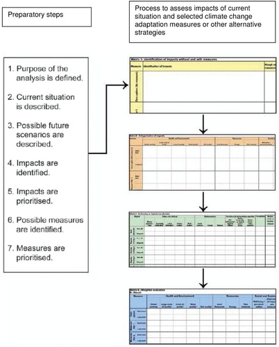
The resulting process tool developed is a step-wise method which aims to support an iterative procedure as it repeats the risk/consequence comparison in an iterative manner during the full process until the final step (proposal for decision) has been reached. The different steps are described below.
Preparatory steps – goal definition and problem/risk/hazard identification
As mentioned above, the first step in a risk analysis is the problem/risk/hazard identification. The identification can be based on previous events or other experience, related events presented in media (or by other means) or a brainstorming activity. For climate-change adaptation purposes a combination of previous experience and other information sources combined with brainstorming activities to identify potential problems is a relevant starting point (Jonsson et al. Citation2011, van Oostrom et al. Citation2011). An important point is to make use of available experience and information preferably at a physical meeting including experts and other stakeholders covering as many as possible of different stakeholder and sustainability perspectives.
The step includes a description of the current situation, potential future scenarios and potential pros and cons today and in the future.
The second preparatory step is to value the risk. As a first step, one can focus on describing the risk and whether it is large, small or insignificant. It is important to take into account both current conditions and potential future scenarios. In case the risk is found not to be acceptable, the next step is to identify potential measures (physical and organisatoric) to reduce the risk. Recently lists of potential measures to manage flood-related risks have been compiled (e.g. Manojlovic and Pasche Citation2008, Pasche Citation2009, Bergman et al. Citation2011 and Water WikiFootnote1). The risk may also be found acceptable, but yet, measures or strategies that may provide benefits can be identified.
The result of this preparatory step constitutes the basis for the subsequent analysis and includes
identification of the impacts of the current situation
identification of potential measures and strategies that may reduce the risk or provide other benefits
decision on the most relevant measures/strategies (physical and organisatoric) for further assessment
updating/specifying the target with the selected measures and the aim of the analysis
Impact identification
The main task of the next step of the process constitutes an important part of a life-cycle inventory, i.e. to identify the economic, environmental, social and other impacts of the proposed measures. The aim with this step is to use the identified impacts (positive and negative including costs) from the preparatory step as a basis for the subsequent assessment. The step is included to encourage the understanding of the subsequent assessment of the selected measures/strategies. It includes a qualitative description of the identified impacts. It is in this step where any need of additional data, calculations or other information is first revealed.
Impact categorisation – merging identified impacts into impact categories
The process continues with an active process to merge the identified impacts into impact categories/indicators that together reflect sustainability. The aim with this step is to facilitate the understanding among the tools participants, and potential additional stakeholders, on how the identified impacts can be assessed by impact indicators. The impacts, which were stated in a broad manner in the previous step, will now be systematically described for all categories, from a local to a global scale and with a life-cycle perspective. The description is qualitative and is devised from short- and long-term perspectives. A need for additional data, calculations or other information appears also in this part of the process.
Impact categories
To assess sustainability as defined by the UN (Brundtland Citation1987) social, environmental and economic perspectives shall be included in the assessment. The goal is to cover relevant impacts with indicators that overlap as little as possible and are independent of each other. Only a limited number of impacts can be included without tiring the users, which would be counterproductive. The impacts considered were based on available LCA methodology, methods for cost benefit analysis and stakeholder views on social aspects. The impact categories were divided into three groups:
Health and environment
Resources
Social and economy
The social and economy category includes well-being/welfare, direct costs and socio-economic aspects as those aspects are recommended to be discussed explicitly at an early stage in risk analyses and any decision processes (IPCC Citation2001, Brooks Citation2003, Füssel and Klein Citation2006, Jonsson et al. Citation2012). In addition the aim was to include the long-term sustainability perspective (Hansson Citation2010), thereby adding the category “flexibility”.
All categories can, when appropriate, be related to the system''s ability to provide ecosystem services. Ecosystem services can be defined as an ecosystem's ability to provide functions (goods and services) to humanity (Fisher et al. Citation2009) or, in other words, the contributions that ecosystems make to human well-being (Haines-Young and Potschin Citation2013). The ecosystem services are divided into four broad categories (MA Citation2005, Haines-Young and Potschin Citation2013): provisioning, such as the production of food and water; regulating, such as the control of climate and disease; supporting, such as nutrient cycles and crop pollination; and cultural, such as spiritual and recreational benefits. For example, increased vegetation, or rain gardens, may contribute to the ability to provide ecosystem services such as regulation of water, air (deposition and filtration), carbon sequestration and impact the biotic environment possibly by increasing the gene pool. Here the impact indicators are wider than only providing well-being from the ecosystem to humans, and the impacts are regarded from both short- and long-term perspectives. Current utilisation of ecosystem services may for example reduce their availability from a long-term perspective. The long-term impacts depend on the speed of utilisation (Volchko et al. Citation2013). There are also impacts that may not be directly related to ecosystem services. For example strategies that cause emissions to air, soil and water may impact the ability to provide ecosystem services but they will also impact other aspects such as health and well-being.
In total 12 sub-impact indicators were selected based on the national environmental objectives and LCA categorisation:
Global warming (release of greenhouse gases, land use or land-changes that contributes to, or reduces, the global warming by for example changes in carbon sequestration).
Large-scale air quality (excluding global warming) including air emissions that contribute to eutrophication, acidification, tropospheric ozone, bioaccumulative air emissions, long-distance transport of particles.
Local air quality (odour, particulates, toxic gases, impacts caused by local design such as vegetation (increased filtration and deposition) and building design creating exposure barriers).
Water quality (drinking water quality, biodiversity, positive and negative impacts on the ecosystems and its services such as water regulation and provision of fish, marine and limnological properties of high conservation value, eutrophication through leakage).
Soil quality (pollution load, biodiversity, positive and negative impacts on the ecosystems and its services such as pollutant filtration and adsorption/absorption and impacts on terrestrial objects of high conservation value).
Land resources (use of land, housing).
Energy (energy consumption).
Raw materials (raw material acquisition).
Well-being/ perceived welfare.
Direct costs (costs for possible impacts and costs for measures).
Socio-economic aspects (infrastructure, cultural, accessibility, business activity, jobs, recreation).
Flexibility (how flexible and adaptive the measures are for possible changed circumstances).
Assessing the impacts
As the aim is to compare the sustainability of different strategies or climate-change adaptation measures in relation to each other, the next step of the process is a quantitative assessment. To be useful among civil servants a simple quantitative grading is useful and colours representing the grading are very informative as output information (F. Björcman, personal communication, 16 June 2009, J. Mannheimer, personal communication, 16 June 2009, Bardos et al. Citation2011). The assessment therefore is represented as a simple grading. Despite being simple as such, the grading can be done based on advanced simulations, but it also allows to be done by expert judgements or as a first step and the views by the other stakeholders involved in the process. The scale selected consists of five grades: two negative (−2, −1), two positive (+1, +2) and one negligible (0) for all categories. In this part of the process the need for more advanced or detailed data or other information may become apparent. If this is the case, the process can be continued or restarted after the missing information has been achieved.
Weighting
Among all the stakeholders and/or decision-makers individual impact categories may be regarded as more or less important than others. Therefore the process tool allows that the individual impact categories can be increased or reduced in weight compared to the others.
The resulting process
The resulting process tool includes the following steps:
Preparatory steps
○ risk identification (current situation today and under future scenarios)
○ compiling available information
○ identification of potential adaptation measures and strategies
Qualitative identification and assessment of risks and potential benefits (current situation and adaptation measures and strategies)
Categorisation and qualitative description of impacts (health, environment, social, economic and others)
Grading of the impacts for each measure and impact category
Figure 1. The resulting process as a decision process support tool (from Andersson-Sköld et al. Citation2011).
The working process
The aim of the process is to facilitate an interactive process. For the most successful result, the process should be iterative, transparent, interactive and participatory (IPCC Citation2001, Ahlhorn Citation2009, Glaas et al. Citation2010, Bardos et al. Citation2011, van Oostrom et al. Citation2011). The detail level can be increased through the working process and depend on available information and demands. Transparency and identification of further information needs are important parts in this iterative process, so that documentation of which bases the assessment is based on (including references, contacts and assumptions) is important (as well as disagreements among experts and why) (Andersson-Sköld et al. Citation2006, Glaas et al. Citation2010, van Oostrom et al. Citation2011).
The first physical meeting is an important starting point for this process. Such an approach is co-productive (Lemos and Morehouse Citation2005), meaning that knowledge is produced through collaboration (Jonsson et al. Citation2012) and facilitating or promoting more transparent decision-making (Nowotny et al. Citation2001, Sarewitz and Pielke Jr. Citation2007, Stirling Citation2008).
Case studies – testing the process tool applicability
The tool development described above has been tested based on practical case study applications involving civil servants in four municipalities, i.e. Arvika municipality, Gothenburg city and Lidköping municipality in Sweden, and Melhus municipality in Norway. The selection of test municipalities is based on cooperation in ongoing projects: within the framework of the Interreg IVB project Strategic Alliance for integrated Water Management Actions (SAWA) civil servants in Lidköping municipality (Sweden), Norwegian Water Resources and Energy Directorate (NVE) and Melhus municipality (Norway) have been involved. Within the framework of the Interreg project climate proof areas (CPA), civil servants from Arvika have been involved, and the tool has further been tested in Gothenburg municipality within the framework of the Formas funded project “Enhancing cities capacity to manage climate change” (Jonsson et al. Citation2012). Here the process of applying the tool, and not the results of the assessments, is presented. The results of the individual assessments from the test cases were finalised in agreement among the participants and are documented in detail in the compiled report by Andersson-Sköld (Citation2012) and consequently not presented here.
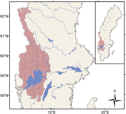
All the Swedish municipals are located by water courses of the Göta River catchment area as shown in . In the catchment area, today there are already events of flooding, and according to climate-change scenarios the risks (probability and extent) will increase during the next decades (Lawrence et al. Citation2011, Olsson et al. Citation2011). Climate change is expected to profoundly influence the hydrology of Norway, Sweden and northern Europe. The annual precipitation is expected to increase by 5–24% by 2100 compared to the conditions for a reference period 1961–1990 (Andréasson et al. Citation2004, Olsson et al. Citation2011). The river runoff is in general expected to be higher in winter, followed by a less-pronounced snowmelt peak and lower summer flows (Olsson et al. Citation2011). Additional consequences of climate change are that rising sea water levels and the changes in precipitation and snow melting patterns likely will lead to impacts such as flooding, slope instability, erosion and soil pollutant mobility, especially in the south-west parts of the country (SOU Citation2007:Citation60, Andersson-Sköld et al. Citation2008). Coastal areas are already exposed to such climate risks. Existing settlements, agricultural areas, industrial localisations and transport routes in the area increase vulnerability further (SOU Citation2007:Citation60). In all case studies, the impact of flooding due to current risks and increased water levels and/or increased precipitation due to climate change has been taken into concern.
Figure 2. Lake Vänern and the Swedish parts of the Göta River catchment area (modified from Lawrence et al. Citation2011).
Lidköping
The case study area Lidköping municipality is located by the shore line of Lake Vänern (see ). Vänern is the largest lake in Sweden and the third largest lake in Europe. Through the centre of Lidköping runs the river Lidan. Previous studies by the municipality have shown that the river Lidan does not pose any threats of flooding of the city centre, neither today nor according to climate-change scenarios of the area (Hogdin et al. Citation2010). The major potential threat due to climate change are consequences of flooding due to water-level changes in the Lake Vänern (Hogdin et al. Citation2010).
The test application of the tool in Lidköping was based on information provided by a previous questionnaire to civil servants in the municipality focusing on the municipal's different departments views, experiences and expectations of potential vulnerability due to potential flooding today and in a changing climate. The questionnaire was made by Lidköping municipality as part of the SAWA project (parts of the results from the questionnaire are presented in Hogdin et al. Citation2010). The test application of the tool was performed by the research team and the senior security strategist in Lidköping municipality on two occasions in 2010.
Gothenburg city
Gothenburg is situated by the west coast of Sweden and the Göta River flows through the city, exposing it to high water flows in the river. The city has a history of flooding due to its exposed location. It harbours vehicle manufacturing, local and regional government, and a growing tourist and visitor sector. Gothenburg encompasses dense settlements, several industrial sites and main transport routes. In a national context, Gothenburg is increasingly seen as a spearhead in working with local responses to climate variation and change (see Glaas et al. Citation2010). For example Gothenburg was one of the first municipalities in 2004 to mandate departments and agencies to assess future impacts of extreme weather events in the light of climate change (Jonsson et al. Citation2012). In 2004 the “Extreme weather group” which comprises officials from municipal departments, companies and national agencies was assigned to assess the potential impacts of extreme weather events, and consequently climate change.
Despite that Gothenburg is seen as a spearhead, is strong in resources and personnel, and works proactive with adaptation to climate change, the civil servants find the need for more information, tools to implement the national environmental objectives and to assess a more holistic picture in the planning process and climate-change adaptation work (Glaas et al. Citation2010). The tool was applied on two occasions in a similar way as the Lidköping case in co-operation with the general planner and head of the Gothenburg Extreme Weather Group. The tool was applied on the case study area Gullbergsvass. The area is located in the centre of Gothenburg by the Göta River. The application involves the renewal of an inner-city area to serve as the transport and communication hub for the city and region (in the comprehensive plan adopted on 26 February 2009, the area is identified as a future development area).
Arvika
The municipality of Arvika with 13,766 inhabitants,Footnote2 situated in Värmland County of Sweden, was in the Swedish Commission on Climate and Vulnerability (SOU Citation2007:Citation60), pointed out as one of the worst affected areas in Sweden with respect to increase in intensive rainfall and extreme flows due to expected climate change. This will pose a challenge for the city of Arvika as the current capacity of the storm water drainage system is insufficient even for today's climate. Arvika has in the past experienced high water levels in lake Glafsfjorden, with critical consequences for the economy, environment and delivery of services (e.g. evacuation of people, damaged property, reduced industrial production, poor sewage treatment, closed railway and roads). Predictions indicate that this kind of event will be more severe and more frequent in the future (SOU Citation2007:Citation60, Lawrence et al. Citation2011, Olsson et al. Citation2011).
The aim of the tool application activity in Arvika was the same as the municipalities' aim within the Interreg IVB CPA project, i.e. to
Analyse the impact of climate change from a local perspective
Identify the consequences for infrastructure and capacity to deliver basic services
Identify and evaluate realistic adaptation alternatives
The application test activity in Arvika was done in spring 2011. The process involved one physical meeting and two additional telephone meetings combined with e-mail communication. The test was done in co-operation with two Investigation Engineers and the Chief Technology Officer. After the physical meeting, the results of the activity were updated by information from the recent environmental risk assessment of the barrier (Vectura 30 June Citation2010).
Melhus
The municipality of Melhus is located in Sør-Trøndelag county, Norway, and includes the valley of the Gaula River as it flows northwards towards its mouth at the Gaulosen, an arm of the Trondheimsfjord. Gaula River arises from in the midlands in the centre of Norway which is a mountainous area that stores huge amounts of water as snow. During summers with a lot of precipitation and low temperatures the snow cover does not melt; thereby huge capacities of water are still stored. In case of warm autumn the stored water may melt and the available water will run down the river and because of the steep river sides the water level rises very fast (SAWA Citation2010).
NVE and Melhus municipality are SAWA partners cooperating in developing a flood risk management plan to provide examples and experience that can be used for the implementation of the flood directive in Norway. The plan includes actions to reduce the flooding and/or the consequences of flooding.
The tool application test in Melhus was done in summer 2011 in co-operation with NVE (one researcher and one division engineer) and four civil servants from departments representing risk management, water management and spatial planning in Melhus municipality.
In Andersson-Sköld (Citation2012) details on the assessment of the individual alternatives, and from each of the decision support tool steps, are provided for Arvika, Lidköping and Melhus. Below are presented the results, not of the assessments of different climate-change adaptation measures or land-use strategies, but of the experiences of applying the tool.
Results of tool application on climate-change adaptation
The use of the tool in all case studies included a brainstorming activity. The aim was to summarise the consequences of the current situation in the event of flooding, identify potential measures that could be taken to reduce the negative consequences (and/or the probability of the event) and to identify consequences (pros and cons) of the suggested measures.
In Lidköping the information regarding the situation (today and in a future climate) was provided by the municipality. Examples of consequences of the current situation in the event of flooding included flooded buildings, reduced or stopped activities of important objects such as the water and sewage system, telecom, heating plant, waste disposal plant, rail, roads and streets, cultural and natural values, due to direct consequences or due to power cuts and secondary natural accidents such as landslides. During the meeting both physical and non-physical measures were suggested. Among the physical measures suggested were to investigate reserve power in the municipal waste water treatment plant, embankment of the sewage plant and to make a dike with garbage and plastic at the combined heating and waste disposal plant. Initially all measures mentioned were physical, while by the end of the meeting also risk investigations and risk mapping were presented as well as activities to increase the awareness including information, education and communication with land owners. Some of the suggested measures were at once regarded as too expensive and complicated for further considerations. These included moving the sewage treatment plant and the heating/waste disposal plant to higher locations. For all suggested measures the pros and cons were identified and the brainstorm results were summarised. During this first meeting also the first attempts to start describing and assessing the impacts of the alternatives were initiated. This step was thereafter done by the research team and at the second meeting the qualitative descriptions and the assessments were updated and finally agreed upon. The tool was found to encourage the discussion and was useful in identifying measures and their consequences.
Also the Gothenburg tool application test showed that the use of the tool encourages discussion, and that the systematic view of sustainability increased awareness of the holistic perspective. In the Gothenburg test the process was done by involving the civil servant in all steps of the process. The process was found to be time consuming on going through all aspects and alternatives. This was accepted when involving only one person, but may be regarded as too time consuming in a large group. Therefore, the suggestion was to start describing the impact categories and to make an assessment for only one measure, as done in Lidköping, on the first occasion. The impact categorisation description and assessment of the other measures/remaining strategy alternatives are suggested to be prepared in advance on a discussion basis at a subsequent meeting. The results can thereafter be discussed and updated during the second event. Also in the Gothenburg test, initially physical measures were suggested and discussed, but as in Lidköping, the discussion when applying the tool directed attention towards institutional adaptation measures as a complement. The main identified negative impacts of the institutional measures were that they were time consuming (municipal officials have very limited available time), may lie outside the mandate of local administrators (e.g. may require national political decisions) and may require organisational changes.
In the Arvika case, the test of the tool was done late in an ongoing risk analysis and planning process and therefore most of the impacts were based on previous and ongoing investigations. The results from the investigations could be included in the matrix. The use of the tool therefore was that the completed matrixes summarised those results and could visualise the impacts of the different alternatives by the colours symbolising the grading. This is, of course, relevant, but the full aim of the tool, i.e. to identify climate-change adaption measures (or other land-use actions such as soil remediation), and their consequences, early in an iterative process was not possible to test any further. Also in this case, however, the process resulted in suggestion of non-physical measures. The main identified negative impacts of the institutional measures, like the Gothenburg case, were that they were time consuming, may lie outside the mandate of local administrators and may require organisational changes.
At Melhus the meeting was initiated by a presentation of potential measures by the researcher at NVE (Dr Bent C Braskerud). The whole group worked through the full process for the reference alternative (doing nothing) and on two measures, i.e. disconnection of water drains and rain gardens. As a result of the process the group was very positive on rain gardens as a risk mitigation measure. The question arose if this was because the idea had been thoroughly worked on and also presented before, or because it is a very good measure, and if the attitude would change as more alternative measures were assessed.
The experience of the procedure was that there is a need to have the explanations of the headings handy during the working process. Some of the headings would gain from being changed. For example, water quality could be clarified further as ecological status and not only chemical quality as this fits into the requirements of the water frame directive and better covers the content of the impact category. The tool has been updated accordingly (as presented in ). Through the discussion it also became apparent that to what extent the goal of the strategy in general can be reached should be included. Thereby the category “target achievement” was added.
Table 1. Impact indicators resulting from the case study-based test application of the decision process tool.
In the spatial planning process on climate-change adaptation measures or for other land-use strategies, the category soil quality was not affected. The impacts related to soil instead were covered under the term land use and under emissions to air and water. The two scales of air-related impacts were difficult to describe and assess individually and therefore it was found that they better be combined as one category. This had not been mentioned among the stakeholders in the other tests, but realised among the research group through the course of the test occasions. The resulting update of the impact categories/indicators are presented in . The tool, as described in the guide by Andersson-Sköld et al. (Citation2011), will for applications on climate-change adaptation and other land-use strategies be updated accordingly.
The activity was said to help in creating awareness on how one can include new measures in the spatial planning and execution. It was also said to contribute to a change in attitude on how to manage a risk (in this case surface water/storm water). The tool and its implementation were further discussed. For example the civil servants discussed how, and for what, they can/should use the tool and what is generic and what is site specific. Aspects that are generic (i.e. similar pros and cons despite where the measure is done) were suggested to be pre-prepared, so there is no waste of time in the discussion process. When going through all aspects of all potential measures, the process was found to be very time demanding and pre-prepared information would be helpful. A suggestion was to make the assessment in advance, while local adaption can be made locally even if the categorisation description and assessment documents are pre-filled. As an alternative, or as a complement, a local expert group could go through a gross-list of physical and organisational measures and pick out the most interesting for the area.
There is a demand for fact sheets on relevant measures including information in general together with information on the impacts on the different categories (global warming, ecological status, etc.). An initial fact sheet has been compiled in parallel as mentioned above (Bergman et al. Citation2011).
The tool was found good and useful. The resulting outputs are also useful as they can be shown to politicians, and to collect documentation on what civil servants in the municipality have emphasised regarding suggestions and recommendations. The discussion also resulted in new suggestions such as to have a technical/special day on flood issues for politicians in Melhus municipality.
General findings from the test cases
In all test cases the short- and long-term perspectives were discussed and assessed in all steps of the process. How to define the time perspectives was also part of the discussion. During the test occasions there was no need to make any weighting of the different aspects in relation to each other, i.e. all aspects were assigned the same value and the last part of the process, the weighting, was therefore omitted.
In general the process and the included steps, as performed in accordance with the suggested procedure, were found interesting but time consuming. The tool was found to be applicable and it was mentioned among the participants as a new way of incorporating civil servants and experts in evaluating alternative risk-reducing measures. The discussions were also mentioned to create awareness. The method was said to encourage a structured discussion as well as documentation of the discussion. One aim of the tool was to identify knowledge gaps. From the discussions, the need for further information and knowledge was identified and documented.
As a result of the discussions throughout the process, new suggestions of measures were formulated. This indicates that it is important to involve the discussion participants in all steps in the process. It would, however, also be relevant to speed up the process as it was found to be time consuming. The process would gain from some preparatory work in advance and/or in between the meetings. For example some of the assessments could be made in between meetings.
Discussion and conclusions
The aim was to develop a tool that encourages discussion, interactivity and at the same time includes an assessment of environmental, social and economic aspects that can be used in the spatial planning process, for climate-change adaptation strategies and for other municipal management and land-use decisions, such as potential soil remediation strategies. The tool was developed to be used as a discussion basis, to show weak points, knowledge gaps and uncertainties, and to visualise trends. As a result of the process, impacts of different alternatives can be elucidated from different perspectives, thereby increasing knowledge and awareness. The method has been shown to be applicable in accordance with the aims. It offers an iterative and systematic discussion framework. All impacts are assessed from short- and long-term perspectives and the impact indicator flexibility offers also an indication of sustainability related to the time perspective.
The tool offers the ability to include several aspects in the decision process. Civil servants in technical sectors often omit environmental aspects. Socio-economic valuation may be accounted for, but relatively unconsciously, and neither systematically, transparently nor by involving stakeholders (Glaas et al. Citation2010). To assess all the various impacts considered, experts from several fields should be involved in the process. The tool process presented here aims to encourage such stakeholder involvement. It can be done through the iterative part of the process, by either involving requested experts directly into the process or incorporating results from additional assessments and analyses.
The tool has been applied in test cases on potential climate-change adaptation measures. It was found to be useful and comprehensive regarding the aspects it aimed to cover. The assessments were based on available information from published risk assessments, and experience and knowledge of the civil servants involved in the test processes. The grading used in the case studies showed trends and revealed uncertainties where further investigations would be useful. The simplicity of the tool encourages an iterative process in which new information and knowledge can be included, and the results updated and uncertainties reduced successively. Each stage in the process produces an interim finding or output. The aim is to proceed through the stages to arrive at a suggestion of the sustainability of selected measures or strategies, which can be used as a guide in the decision-making process. Such a discussion will both contribute to increase the awareness among the participantsand ensure that all sustainability aspects (including environmental impacts) are more systematically included than in the current spatial planning process.
Here the tool was applied once in the decision processes in Arvika, Gothenburg, Lidköping and Melhus. The tool is aimed to be an interactive decision support. The final result of applying the tool through a full decision process has not yet been tested. On one occasion, however, the method has been shown to offer a structured and more holistic approach, which is especially useful as a sorting filter early in a planning or decision process. The framework is a checklist taking into account impacts on short and long terms, as well as wider sustainability aspects, i.e. impacts on health and environment, resources, social and economic impacts. Especially the step in which the sustainability aspects are described verbally (by written text) is novel, and has been found to encourage the awareness of the wider impacts of potential solutions. This process has also been found to be conducive to taking a higher variety of actions/measures into consideration than without applying the tool. The reason is that several experts have been discussing several sustainability impacts together, and through the process the awareness of other potential solutions arises. The tool does not provide all potential strategies/measures that could be applied to obtain the wanted outcome, but the process and the discussion contribute to identify new solutions.
The process does not necessarily provide higher transparency than found today in general, but the simplistic way of filling the templates provided in the guideFootnote3 offers a base to encourage increased transparency.
As with all planning and decision-making processes, the outcome of the results is based on the participants in the process. The tool does not offer a method to decide on who shall be involved in the process. The stakeholders involved depend on what is to be assessed. Therefore it is important to define the group of stakeholders to be involved in the process at an early stage, i.e. before the first brainstorm meeting, and if needed expand it throughout the process in order to reduce the bias as the knowledge and interests vary among different experts and other stakeholders. This is in accord with recommendations recently published for wider application of gentle remediation options (Cundy et al. Citation2013). As with all decision support tools, there is a concern that non-experts may apply the tool inappropriately. We therefore recommend that use of the tool should involve professionals to encompass a wide range of professional and lay opinions.
The main disadvantage is that the application is time demanding. This can be reduced by preparatory work for each utilisation but also by development of generic information that can speed up the discussion process. Another barrier to implementation is the idea of such a systematic procedure as a complement to, or even in, the everyday processes. The tool will not be used unless the advantages become apparent in combination with the acceptance of the idea to include such systematic assessment in the agenda of the normal risk analyses and spatial planning processes.
Acknowledgements
The tests of the tool have been done in co-operation with experts and civil servants from NVE and the municipalities of Melhus, Arvika and Lidköping and the City of Gothenburg.
Additional information
Funding
Notes
1 http://iwawaterwiki.org/xwiki/bin/view/Main/;http://iwawaterwiki.org/xwiki/bin/view/Organizations/SAWA (Strategic Alliance for Water Management Actions).
2 In 2010 (http://population-of.com/en/Sweden/22/Arvika/, 29 February 2012).
References
- Ahlhorn, F., 2009. Long term perspective in Coastal Zone Development, multifunctional coastal protection zones, Universität Oldenbrug. Berlin: Springer Verlag. ISBN 978-642-01774-2.
- Andersson-Sköld, Y., 2012. Collocation of experiences with SGI matrix based decision support tool (MDST) within SAWA. Statens geotekniska institut, SGI. Linköping: Varia 627, 17.
- Andersson-Sköld, Y., Norrman, J., and Kockum, K., 2006. Survey of risk assessment methodologies for sustainable remediation. VALDOR (Values in Decisions On Risk), Stockholm, Sweden, 135–142.
- Andersson-Sköld, Y., et al., 2007. Coal tar-containing asphalt – resource of hazardous waste? Journal of Industrial Ecology, 11, 99–116. doi: 10.1162/jiec.2007.1106
- Andersson-Sköld, Y., et al., 2008. Climate change in Sweden – geotechnical and contaminated land consequences. WSEAS – international conference on environmental and geological science, Malta, 52–57.
- Andersson-Sköld, Y., et al., 2011. Matrix decision support tool for evaluation of environmental, social and economic aspects of land use. Statens geotekniska institut, SGI. Linköping: Varia 613, 17.
- Andréasson, J., et al., 2004. Hydrological change – climate change impact simulations for Sweden. Ambio, 33, 4–5. doi: 10.1579/0044-7447-33.4.228
- Bardos, R.P., et al., 2011. Crop-based systems for sustainable risk-based land management for economically marginal damaged land. Remediation Journal, Autumn, 11–33. doi: 10.1002/rem.20297
- Barnett, J. and O'Neill, S., 2010. Editorial: maladaptation. Global Environmental Change, 20, p211–213. doi: 10.1016/j.gloenvcha.2009.11.004
- Bergman, R., et al., 2011. Åtgärdsförslag vid ett förändrat klimat i Sverige – förändrad nederbörd och vattenståndsnivåer [Measures to manage climate change in Sweden – altered rainfall and sea levels]. SAWA report and Swedish Geotechnical Institute, Varia 618, Linköping.
- Birkmann, J., 2006. Measuring vulnerability to promote disaster-resilient societies: conceptual frameworks and definitions. In: J. Birkman, eds. Measuring vulnerability to natural hazards: towards disaster resilient societies. Tokyo: United Nations University Press, 9–53.
- Brooks, N., 2003. Vulnerability, risk and adaptation: a conceptual framework. Working paper 38, Tyndall Centre for Climate Change Research and Centre for Social and Economic Research on the Global Environment (CSERGE).
- Brundtland, G.H., 1987. Our common future. Nairobi: United Nations Environment Programme.
- Chiesura, A., 2004. The role of urban parks for the sustainable city. Landscape and Urban Planning, 68 (1), 129–138. doi: 10.1016/j.landurbplan.2003.08.003
- Cundy, A.B., et al., 2013. Developing principles of sustainability and stakeholder engagement for “gentle” remediation approaches: the European context. Journal of Environmental Management, 129, 283–291. doi: 10.1016/j.jenvman.2013.07.032
- Dempsey, N., et al., 2011. The social dimension of sustainable development: defining urban social sustainability. Sustainable Development, 19 (5), 289–300. doi: 10.1002/sd.417
- Dempsey, N., Brown, C., and Bramley, G., 2012. The key to sustainable urban development in UK cities? The influence of density on social sustainability. Progress in Planning, 77 (3), 89–141. doi: 10.1016/j.progress.2012.01.001
- Diamond, M.L., et al., 1999. Life-cycle framework for assessment of site remediation options: method and generic survey. Environmental Toxicology and Chemistry, 18, 788–800. doi: 10.1002/etc.5620180427
- Directive 2000/60/EC of the European Parliament and of the Council establishing a framework for the community action in the field of water policy (the EU Water Framework Directive).
- Directive EC 1907/2006 of the European Community Regulation on chemicals and their safe use (REACH).
- Edvardsson Björnberg, K. and Hansson, S.O., 2011. Five areas of value judgement in local adaptation to climate change. Local Government Studies, 37 (6), 671–687. doi: 10.1080/03003930.2011.623159
- European Commission, 2009. White paper: adapting to climate change: towards a European framework for action. COM 2009 147/4 final. Brussels: EC.
- Fahy, F. and Ó Cinnéide, M., 2008. Developing and testing an operational framework for assessing quality of life. Environmental Impact Assessment Review, 28 (6), 366–379. doi: 10.1016/j.eiar.2007.10.002
- Fisher, B., Turner, K.R., and Morling, P., 2009. Defining and classifying ecosystem services for decision making. Ecological Economics, 68, 643–653. doi: 10.1016/j.ecolecon.2008.09.014
- Füssel, H.M. and Klein, R.J.T., 2006. Climate change vulnerability assessments: an evolution of conceptual thinking. Climate Change, 75, 301–329. doi: 10.1007/s10584-006-0329-3
- Glaas, E., et al., 2010. Managing climate change vulnerabilities: formal institutions and knowledge use as determinants of adaptive capacity at the local level in Sweden. Local Environment, 15 (6), 525–539. doi: 10.1080/13549839.2010.487525
- Haines-Young, R. and Potschin, M.m., 2013. Common International Classification of Ecosystem Services (CICES): consultation on Version 4, August–December 2012. EEA Framework Contract No EEA/IEA/09/003. Available form www.cices.eu or www.nottingham.ac.uk/cem [Accessed 23 May 2014].
- Hansson, S., 2010. Technology and the notion of sustainability. Technology in Society, 32, 274–279. doi: 10.1016/j.techsoc.2010.10.003
- Hogdin, S., et al., 2010. Flood and risk mapping according to the flood directive Scenarios in Lidköping and Karlstad. Länsstyrelsen i Västra Götalands län [County administration of Västra Götaland], Report number: 2010:69. Available from: www.lansstyrelsen.se/vastragotaland/Sv/Publikationer [Accessed 23 May 2014].
- IIASA, 2012. Atmospheric Pollution and economic Development program (APD). Available from: http://www.iiasa.ac.at/web/home/research/researchPrograms/GAINS.en.html [Accessed 23 May 2014].
- IPCC, 2001. The scientific bases, working group I. Intergovernmental Panel on Climate Change. Available from: http://www.ipcc.ch/ [Accessed 1 February 2012].
- IPCC, 2007a. Climate Change 2007: Synthesis report – summary for policymakers. Intergovernmental Panel on Climate Change. Available from: http://www.ipcc.ch/ [Accessed 1 February 2012].
- IPCC, 2007b. Climate Change 2007: impacts, adaptation and vulnerability working group ii contribution to the Intergovernmental Panel on Climate Change fourth assessment report, summary for policymakers. Intergovernmental Panel on Climate Change. Available from: http://www.ipcc.ch/ [Accessed 1 February 2012].
- ISO 14040, 2006. Environmental management –life cycle assessment –principles and framework.
- Johansson, M., 2008. Barriers and bridges – communicative conditions in the Swedish environmental objective performance (in Swedish). Linköping Studies in Arts and Science, Dissertation No. 469. (PhD). Linköping University, Linköping.
- Jonsson, A., et al., 2011. Verktygslåda för klimatanpassningsprocesser. Från sårbarhetsbedömning till sårbarhetshantering [Toolbox for climate adaptation processes: from vulnerability assessment to vulnerability management]. CSPR Report 2011:1 (in Swedish).
- Jonsson, A., et al., 2012. Cities' capacity to manage climate vulnerability: experiences from participatory vulnerability assessments in the lower Göta Älv Catchment, Sweden. Local Environment: The International Journal of Justice and Sustainability, 17 (6–7), 735–750.
- Keirstead, J. and Leach, M., 2008. Bridging the gaps between theory and practice: a service niche approach to urban sustainability indicators. Sustainable Development, 16 (5), 329–340. doi: 10.1002/sd.349
- Lawrence, D., et al., 2011. Climate change impacts and uncertainties in flood risk management: examples from the North Sea Region. A report of working group 1 – adaptive flood risk management SAWA Interreg IVB Project, Norwegian Water Resources and Energy Directorate, Report Number 05–2012.
- Lemos, M.C. and Morehouse, B.J., 2005. The co-production of science and policy in integrated assessments. Global Environmental Change, 15, 57–68. doi: 10.1016/j.gloenvcha.2004.09.004
- Manojlovic, N. and Pasche, E., 2008. Integration of resiliency measures into flood risk management concepts of communities. Hamburg: TUHH (Technical University of Hamburg-Harburg), WIT, eLibrary. Available from: http://library.witpress.com/pages/PaperInfo.asp?PaperID=19304 [Accessed 23 May 2014].
- Miljömålsrådet, 2008. Miljömålen i korthet … och en sammanfattning av miljömålsrådets utvärdering. Bromma: Miljömålsrådet.
- Millennium Ecosystem Assessment (MA), 2005. Ecosystems and human well-being: synthesis. Washington, DC: Island Press, 155.
- Nowotny, H., Scott, P., and Gibbons, M., 2001. Re-thinking science: knowledge and the public in an age of uncertainty. Cambridgec: Polity Press.
- Olsson, J., et al., 2011. Using an ensemble of climate projections for simulating recent and ear-future hydrological change to Lake Vänern in Sweden. Tellus, 63A, 126–137. doi: 10.1111/j.1600-0870.2010.00476.x
- van Oostrom, N., et al., 2011. Adaptation toolkit for the North Sea Region in a changing climate [online]. CPA final report Work Package 4, 81 pp. Available from: http://www.newsletter.climateproofareas.com/reports/end%20products/CPA-WP4-endreport_web.pdf [Accessed 26 May 2014].
- Pacione, M., 2003. Urban environmental quality and human wellbeing – a social geographical perspective. Landscape and Urban Planning, 65 (1–2), 19–30. doi: 10.1016/S0169-2046(02)00234-7
- PAS 2050, 2008. Specification for the assessment of the life cycle greenhouse gas emissions of goods and services. Publicly Available Specification, October 2008, BSI.
- Pasche, E., 2009. Concept for a transnational strategy in developing a flood risk management plan. Hamburg: TUHH, Wasserbau; Interreg IVb, SAWA.
- Roth, L., 2005. Reuse of construction materials, environmental performance and assessment methodology. Linköping Studies in Science and Technology, Dissertation No. 928. Linköping University, Linköping.
- Roth, L. and Eklund, M., 2003. Environmental evaluation of reuse of by-products as road construction materials in Sweden. Waste Management, 23, 107–116. doi: 10.1016/S0956-053X(02)00052-1
- Sarewitz, D. and Pielke, Jr., A., 2007. The neglected heart of science policy: reconciling supply of and demand for science. Environmental Science and Policy, 10, 5–16. doi: 10.1016/j.envsci.2006.10.001
- SAWA, 2010. Municipality of Melhus, Norway. Proceedings of the SAWA-mid-term conference, 25–27 May 2010, Gothenburg, 62–63. Available from: http://lsbg.hamburg.de/contentblob/2312158/data/sawa-conference-gothenburg.pdf [Accessed 23 May 2014].
- Schuster, R.L. and Highland, L.M., 2006. The third Hans Cloos Lecture. Urban landslides: socioeconomic impacts and overview of mitigative strategies. Bulletin of Engineering Geology and the Environment, 66, 1–27. doi: 10.1007/s10064-006-0080-z
- SKL, 2011. Kommunernas arbete med klimatanpassning [The municipalites work on climate adaptation, in Swedish], Report Series SKL granskar, Sveriges kommuner och landsting, December 2011. Available from: http://www.skl.se/vi_arbetar_med/tillvaxt_och_samhallsbyggnad/plan/klimatanpassning/sa-arbetar-kommunerna [Accessed 01 February 2012].
- SOU 2007:60 (Swedish Government Commission Report), 2007. Sweden facing climate change: threats and opportunities. The Commission on Climate and Vulnerability, Swedish Government Official Reports. Stockholm: Edita, 679.
- Stirling, A., 2008. “Opening up” and “closing down”: power, participation and pluralism in the social appraisal of technology. Science, Technology, & Human Values, 33, 262–294. doi: 10.1177/0162243907311265
- Suer, P. and Andersson-Sköld, Y., 2011. Biofuel or excavation? – Life cycle assessment (LCA) of soil remediation options. Biomass and Energy, 35 (2), 969–981. doi: 10.1016/j.biombioe.2010.11.022
- Suer, P., Andersson-Sköld, Y., and Andersson, J., 2009. Local gain, global loss – the environmental cost of action. In: A. Singh, R.C. Kuhad, and O.P. Ward, eds. Advances in applied bioremediation, soil biology 17. Berlin: Springer-Verlag, 21–34.
- UN-ECE, 1991. Protocol of the 1979 convention on long-range transboundary air pollution concerning the control of emissions of volatile organic compound or their transboundary fluxes. ECE(EB.AIR/30), United Nations Economic Commission for Europe.
- UNFCC, 2009. Kyoto protocol to the United Nations framework convention on climate change. Available from: http://unfccc.int/essential_background/kyoto_protocol/items/1678.php [Accessed 1 February 2012].
- Vectura, 2010. MKB (Miljökonsekvensbeskrivning) avseende vattenhantering för översvämningshantering i Arvika [EIA (environmental impact assessment) associated application for water activities regarding flood protection of Arvika town], 30 June 2010.
- Volchko, Y., et al., 2013. Incorporating the soil function concept into sustainability appraisal of remediation alternatives. Journal of Environmental Management, 129, 367–376. doi: 10.1016/j.jenvman.2013.07.025
- Zah, R., et al., 2007. Life cycle assessment of energy products: environmental assessment of biofuels. Swiss Federal Institute of Materials Science and Technology Research (EMPA). Available from: www.bioenergywiki.net/images/8/80/Empa_Bioenergie_ExecSumm_engl.pdf [Accessed 1 February 2012].