
 ?Mathematical formulae have been encoded as MathML and are displayed in this HTML version using MathJax in order to improve their display. Uncheck the box to turn MathJax off. This feature requires Javascript. Click on a formula to zoom.
Abstract
Fuzziness is an inherent property of geographical phenomena and the processes of data acquisition, processing, and analysis often introduce uncertainty. Existing methods predominantly use fuzzy set (FS) theory to capture the fuzziness of geographical phenomena as fuzzy spatial objects. However, this approach has a conceptual confusion regarding fuzziness, uncertainty, and vagueness, and the membership degree is expressed using accurate values that ignore uncertainty. Furthermore, FS-based methods lack a vague temporal descriptor. Herein, a vague-spatiotemporal-object model based on the interval type-2 FS theory is proposed to express the vagueness of spatiotemporal objects. To verify the feasibility and superiority of the proposed method, the fuzzy and vague clustering algorithm was used to classify the vegetation cover types on Poyang Lake Plain, China. Furthermore, the classification accuracy was validated via field investigations, and its ability to identify the wet season of the area was verified via the annual vague water area changes of Poyang Lake. The results indicate that, compared with the spatial object model based on FSs, the proposed method increases the ability to measure membership error and express spatiotemporal vagueness.
Introduction
Spatiotemporal objects are special geographic objects that contain both spatial and temporal characteristics and exist in the real world in a vague form (Fisher Citation2000). The vagueness of spatiotemporal objects is composed of objective boundary fuzziness and uncertainty caused by human factors (Pfoser and Tryfona Citation2001). Fuzziness is not affected by human cognition and is an inherent attribute of geographical spatiotemporal objects (Smith and Varzi Citation2000), whereas uncertainty depends on human beings and may change with the level of human cognition.
Modern Geographic Information Systems (GIS) tend to simplify geographic information into precise data for processing, which reduces the difficulty of calculation and analysis and promotes the development of GIS to a certain extent. However, the disadvantages arising from this simplification have become increasingly evident with the increasing demand for GIS applications (Guo et al. Citation2019). The expression and processing of vague geographical objects determine the accuracy of GIS in the expression and analysis of geographical entities or phenomena (Griffith et al. Citation2015), which represent a basic component and key problem in the field of geographic information science (Cross and Firat Citation2000).
The fuzzy set (FS) and its extension theory provide an effective tool for the conceptualization and modeling of fuzzy spatial objects (Burrough and Frank Citation1996). Research on this topic has led to substantial progress in the field (see Section Related work for more details); however, some problems persist: (1) There is no unified standard for understanding the concepts of fuzziness, uncertainty, and vagueness of spatiotemporal objects. (2) Most of the existing fuzzy spatial object models ignore the uncertainty of fuzzy spatial objects and cannot measure the membership degree error. (3) Current research pays less attention to the vague time feature.
To address these problems, this study redefines the concepts of fuzziness, uncertainty, and vagueness to ensure that they are unified and eliminate confusion. Based on these redefined concepts, the vague spatiotemporal objects model combined with the Interval Type-2 FS (IT2 FS) is established. The vague spatiotemporal objects model based on IT2 FS, considering the membership error, can describe and express the temporal features. Furthermore, the superiority and practicability of the proposed model in rationality and expression compared with the previous model are verified. This approach provides a theoretical basis and an effective tool to describe and realize dynamic geographical phenomena in GIS.
Related work
Fuzzy set theory and its extension
Zadeh (Citation1965) proposed FS based on set theory to describe the fuzziness that exists in the real world. Several scholars have introduced FS into GIS to solve the vagueness problem that widely exists in the geographical space (Burrough Citation1989, Liu et al. Citation2019). However, the membership degree error occurs because of the application of various methods by different users in different situations. Therefore, researchers have questioned the FS theory because it uses accurate values to represent the membership degree but cannot measure the membership degree error (Guo and Cui Citation2012).
Zadeh (Citation1975) proposed the concept of a higher-order fuzzy set (HFS) to address this problem, where the primary memberships are still FS and the secondary memberships describe the uncertainty of these primary memberships. Various researchers have summarized the development and application of HFS and compared them with FS (Castro et al. Citation2007, John and Coupland Citation2007), whereas others believe that it is more objective to study vague spatiotemporal objects using HFS (Fisher et al. Citation2007, Guo and Cui Citation2012). Although HFS can measure the membership error of FS, it is still in the theoretical stage because of the computational complexity involved.
Liang and Mendel (Citation2000) proposed IT2 FS, which divided the membership functions of HFS into upper membership functions (UMFs) and lower membership functions (LMFs). As a special type of HFS, IT2 FS can measure the membership error of FS and substantially reduce the complexity of HFS (Hwang and Rhee Citation2007).
Vague spatiotemporal objects model based on FS and their extension theory
Studies have used the FS and its extension theory to express the fuzziness of spatiotemporal objects. However, they predominantly focus on the description and expression of the fuzziness of spatial objects (Zhan Citation1998, Schneider Citation1999, Tang Citation2004, Dilo Citation2006). The description and expression of the fuzziness of a time feature are the most difficult aspects in the study of geographical spatiotemporal objects. Although some achievements have been made in relevant research (Pfoser and Tryfona Citation2001, Sözer et al. Citation2008, Chen Citation2009), various issues remain. The models mentioned above are based on FS and cannot measure the membership error. While some studies have attempted to use HFS to solve this problem (Zhu and Du Citation2006, Adesah et al. Citation2017), the research progress in this area has remained slow, owing to the complex calculations involved. IT2 FS is widely utilized to study higher-order fuzzy geographical phenomena (Jifa and Tiejun Citation2014b, Guo et al. Citation2018, Yang et al. Citation2019). It is easier to calculate than HFS and compensates for the inability of FS to measure the membership error. However, IT2 FS ignores the vagueness expression of the temporal feature.
The studies cited above have conceptual confusion in their understanding of fuzziness, uncertainty, and vagueness, which leads to further disputes and these concepts first need to be unified to eliminate the confusion.
Fuzziness, uncertainty, and vagueness of geographical spatiotemporal objects
Fuzziness of geographical spatiotemporal objects
Fuzziness refers to the nature of objective existence in the real world and does not change with human cognitive abilities and time. A fuzzy boundary in fuzzy geographic information space (Schneider Citation1999) can be divided into three types, Types 1–3, as illustrated in .
Figure 1. The three types of fuzzy boundaries in .
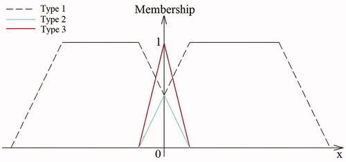
Type 1: The fuzzy boundary is a part of the fuzzy spatiotemporal objects and its membership degree ranges from 0 to 1. This type of fuzzy boundary can express the fuzziness of spatiotemporal objects in location, attribute, or time, such as the boundaries of dunes or lakes changing with time.
Type 2: The fuzzy boundary belongs to two or more fuzzy spatiotemporal objects with different membership degrees. The sum of all membership degrees is equal to 1 and is the transition from one geographical feature to another, e.g. the transition zone between a grassland and a desert.
Type 3: A fuzzy boundary is used to distinguish fuzzy spatiotemporal objects from others. Here, a fuzzy boundary exists independent of any type of fuzzy spatiotemporal object. An example is the change process of the positional relationship between a moving vehicle and a road.
Uncertainty in geographical spatiotemporal objects
Uncertainty denotes the inability to accurately assess the fuzzy degree of spatiotemporal objects when people collect, store, manage, calculate, analyze, and describe them because of the limitations of cognition as well as scientific and technological developments (Griffith et al. Citation2015). For example, the accuracy and time required for separate individuals to complete the same task can widely differ because a user’s knowledge reserve cannot determine the real state of things. There are three sources of uncertainty for fuzzy spatiotemporal objects: cognitive uncertainty, defining uncertainty, and measurement error.
Cognitive uncertainty: The human knowledge reserve is insufficient to determine the actual state of geographical objects, or there are inconsistencies in the descriptions of objective components caused by the differences in ability and experience.
Defining uncertainty: Several terms have exact meanings, however, the meaning of several other words is not clear, such as ‘deep-sea’ and ‘warm’. These words describe the general characteristics of a phenomenon; they have a clear connotation and cover most of a phenomenon, but they have no clear boundaries to describe them.
Measurement error: Every physical quantity has an objective size, which is referred to as the actual value of the physical quantity. The measurement result is affected by the specific person, environment, instrument, and method, and therefore deviates from the true value, which is a phenomenon known as measurement error.
Vagueness of geographical spatiotemporal objects
Vagueness is an uncertain expression of fuzziness. Fuzzy spatiotemporal objects with uncertainty are called vague spatiotemporal objects, as shown in .
Figure 2. Classification frame of vague spatiotemporal objects.
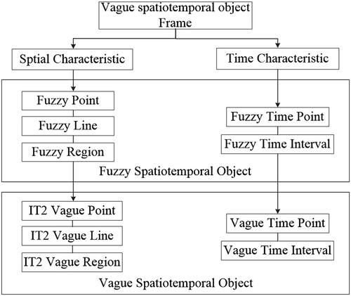
Spatiotemporal objects include both spatial and temporal fuzziness. Currently, GIS divides spatial objects into points, lines, and regions, which are extended to fuzzy points, fuzzy lines, and fuzzy regions (i.e. the fuzzy spatial objects model), respectively, to express the objective fuzziness of spatial object location features and attribute features. A timing feature refers to a phenomenon or object that changes with time and it can be divided into time points and time intervals.
Vague spatiotemporal objects are fuzzy spatiotemporal objects with uncertainty. The spatial characteristics of fuzzy spatiotemporal objects can be extended to vague points, lines, and regions, representing the spatial characteristics of vague spatiotemporal objects. A fuzzy time feature can be extended to vague time points and time intervals to represent time feature vagueness.
Expressions of vague spatiotemporal objects
Expressions of vague spatial objects
Vague point objects
A vague point contains vagueness for locations or attributes in vague geographic information space but it can only be determined within a certain range, as shown in . Here, n vague points can together form a group of vague points, as shown in and the membership μ of a vague point is expressed by EquationEquation (1)
(1)
(1) :
(1)
(1)
where
and
represent the UMF and LMF of the vague point, and
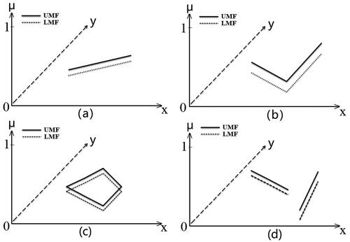
Vague line objects
A vague line is a type of linear entity whose location or attribute in has vagueness. The membership degree of any point on a vague line can only be determined within a certain range, expressed as
which includes a straight line, discount, loop, and multi-line (). The membership μ of
is expressed by EquationEquation (2)
(2)
(2) :
Figure 3. (a) Interval type-2 vague point and (b) multi-interval type-2 vague points.
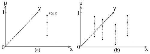
Figure 4. (a) Vague lines, (b) vague broken lines, (c) vague loop lines, and (d) multiple-vague lines.
where represents a point on
in
and
represent the UMF and LMF of the
respectively; and
Vague region objects
In the membership degree of the vague region is
where
and
represent the UMF and LMF, respectively,
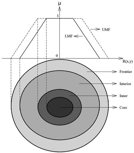
Jifa and Tiejun (Citation2014a) intuitively divided the vague region into the core, inner, interior, frontier, and outer regions (). The membership degree of the core region is one, and it gradually decreases from the core to the outer region.
Figure 5. Structure of an interval type-2 fuzzy region.
Expression of vague temporal objects
In if
is the vague time of dynamic geographical phenomena, then the membership degree of
is
where,
and
represent the UMF and LMF, respectively.
As shown in , vague time is represented by a time axis that is divided into vague start/end inner boundary, central boundary, outer boundary, outer region, and definite experience time, which can be expressed as
and
respectively.
Figure 6. Interval type-2 fuzzy membership function of time.
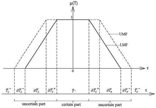
The range of membership degrees μ of
and
is
where
The relationship between
and
can be divided into the following four types:
When
the vague time interval is simplified into a fuzzy time point, and the starting time of dynamic geographical phenomena is fuzzy.
When
When
Experimental study
This section considers the farmland cover types and the water area change of Poyang Lake Plain, China, as examples to illustrate the application and superiority of the proposed method in a GIS.
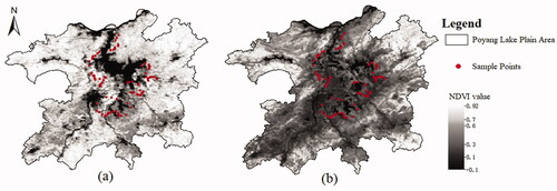
Poyang Lake is the largest freshwater lake in China and is located in northern Jiangxi Province, on the south bank of the middle and lower reaches of the Yangtze River. Its geographical location is 28°22′–29°45′ N, 115°47′–116°45′ E and typically experiences its wet season from April to September and its dry season is from October to March. The vegetation cover types in the study area were classified according to the research results of Yin et al. (Citation2013): forest land [normalized difference vegetation index (NDVI) > 0.7], grassland (0.6 < NDVI < 0.7), farmland (0.3 < NDVI < 0.6), non-vegetated (0.1 < NDVI < 0.3), and water body (NDVI < 0.1). As shown in , the volume of the lake significantly varies throughout the year, with showing the NDVI in July 2013 where the lake was characterized by high water, with rapid vegetation growth. shows the NDVI in December 2013, with the decrease in precipitation in winter, there was a rapid reduction in the water area and vegetation coverage.
Figure 7. Normalized difference vegetation index (NDVI) of Poyang Lake Plain in (a) July 2003 and (b) December 2003.
In this study, the fuzzy C-means clustering (FCM) and interval type-2 fuzzy C-means clustering (IT2FCM) algorithms were used to complete the fuzzy and vague classification of vegetation cover types. The superiority of the proposed model can be demonstrated by comparing the accuracy of fuzzy and vague points. Using the water area of Poyang Lake in 2013, the wet season can be determined by verifying the practicability of the proposed model.
Datasets
Remote-sensing data
The remote-sensing data used in this study were the SPOT-VGT maximum value composite NDVI dataset released by the Flemish Institute of Technology in Belgium. This includes the spectral reflectance of four bands synthesized every 10 d with a spatial resolution of 1 km. The dataset was pre-processed before use, including geometric correction, atmospheric correction, and cloud removal.
Field survey data
Through field investigation, 117 points were selected as sample sites, with 93 of them being farmland ().
Data processing
FCM is used to construct fuzzy representations of fuzzy geographical phenomena. The vegetation cover types were divided into ‘water body’, ‘non-vegetated’, ‘Farmland’, and ‘woodland’ (Tang Citation2004). The fuzzy parameter was set to 2, which is an experience value, and the iteration stop threshold was 0.001.
IT2FCM (Hwang and Rhee Citation2007) was used for the vague classification of spatiotemporal data. The number of categories was set to 4, fuzzy parameters were set to 1.3 and 2.5, respectively, and the termination standard value was <0.001.
Farmland classification accuracy comparison
Fuzzy points
shows the membership grade of each point pixel to the water body, non-vegetated, rice field, and woodland vegetation cover types. Sampling point A was used to explain the membership of pixels to each vegetation cover type in detail. As shown in , point A was most likely to belong to the farmland and the fuzzy line was not expressed separately because it was composed of several continuous fuzzy points.
Figure 8. Results of fuzzy classification of Poyang Lake Plain on August 10.
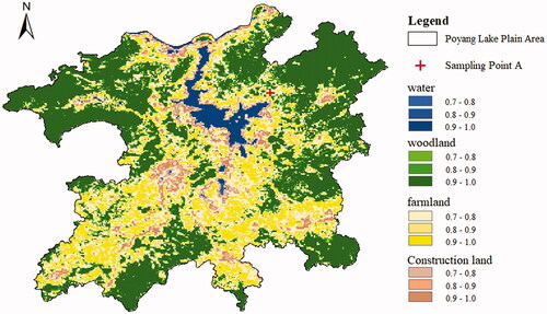
Table 1. Fuzzy membership degree of point A to each land use type.
Vague points
show the UMF and LMF of each pixel within the four vegetation categories. Sampling point B in was used to explain the membership of the pixels to each vegetation cover type in detail. As shown in , point B was most likely located within farmland. Vague lines are not expressed separately here because they are composed of several continuous vague points in a vague space.
Figure 9. Results of vague classification of Poyang Lake Plain on August 10. (a) Upper membership grade and (b) lower membership grade.
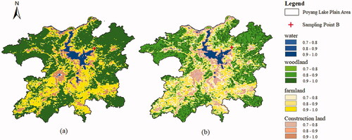
Table 2. Upper and lower membership function of point B to each vegetation cover type.
Verification of the farmland classification accuracy
To verify the practicability and superiority of the proposed model, it was compared with the traditional FS-based model shown in . Initially, 117 points with a membership degree of one for farmland were selected in the traditional model and 93 of them were verified as accurate through field investigations. The classification accuracy of the traditional model was 79.49%. Compared with the proposed model, it was found that among the 117 points, the average values of UMF and LMF >0.9, 0.8, 0.7, and 0.6 were 81, 114, 116, and 117, respectively, of which 79, 90, 92, and 93 were determined as farmland; the classification accuracy was 97.53, 78.95, 79.31, and 79.49%, respectively.
Table 3. Classification accuracy of fuzzy and vague farmland.
The classification according to the traditional model and that of the proposed model were satisfactory, but the traditional model uses an accurate value, which cannot measure the membership error. The proposed method can express the vagueness of the results.
Distinguishing the wet season
Vague water regions
The water body was taken as an example to express the membership of the vague region. As shown in , the vague water area of Poyang Lake, composed of water, fuzzy water, and non-water, varies greatly between July and December. show the LMF and UMF of Poyang Lake in July and December; the attributes of each part are shown in .
Figure 10. Classification results of vague region objects (water body). (a) the LMF of Poyang Lake in July, (b) the UMF of Poyang Lake in December, (c) the LMF of Poyang Lake in December, (d) the UMF of Poyang Lake in December.
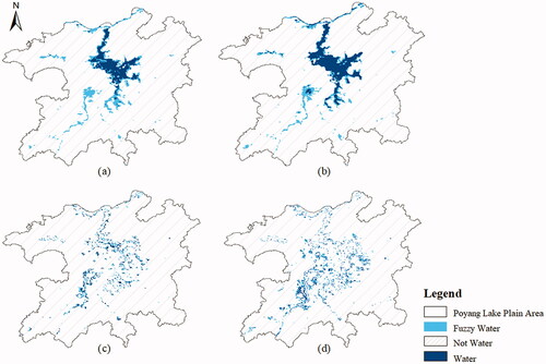
Table 4. Attributes difference of the vague water region.
Distinguishing the wet season
shows the vague area change of Poyang Lake in 2013 and the membership degree of each month in the wet season. It can be seen that the vague water areas of Poyang Lake are composed of minimum water area, minimum fuzzy water area, maximum water area, and maximum fuzzy water area. The water area changes significantly throughout the year. Whereas the vague start time of the wet season is in April (0.2 < LMF and UMF <0.8), the actual wet season is from May to August (0.8 ≤ LMF and UMF ≤ 1), and the vague end time of the wet season is from September to October (UMF > 0.8), which is consistent with objective facts (Wan et al. Citation2017).
Figure 11. Lake area change and membership degree of wet season.
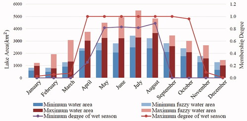
The beginning and end of the lake wet season is not a sudden change, but a gradual process. The proposed model is expressed vaguely, and can objectively show its change law for any geographic information with gradient attribute or vague value.
Conclusions
In this study, we unified the concepts of fuzziness, uncertainty, and vagueness, thereby eliminating the confusion in their concepts such that they are consistent with objective facts. Subsequently, on this basis, the IT2 FS was used to express vague spatiotemporal objects. To verify the superiority of the proposed model, its classification accuracy of farmland cover types was compared to that of the traditional model based on fuzzy and vague points. Furthermore, identifying the wet season based on the annual vague water area change of Poyang Lake, China, shows the practicability of the proposed model. The results show that the proposed method is more suitable to express geographic spatiotemporal information with gradual change or membership error (i.e. vague spatiotemporal information), which lays a foundation for GIS to describe, express, and query dynamic spatiotemporal geographic phenomena more objectively.
During the past 10 years, several studies have focused on the topological relations of fuzzy spatial objects and provided valuable results. Future research should focus on the description and expression of the relationships between vague spatiotemporal objects based on improving the proposed vague spatiotemporal object model.
Author contributions
Yue Yin formulated the overarching research goals, collected data, conducted the experiment, and wrote the manuscript. Yehua Sheng directed all the work and was responsible for the quality audit of the manuscript. Yufeng He contributed to the concept of the current research and provided experimental ideas. Jiarui Qin formatted the manuscript and corrected any errors observed.
Disclosure statement
All authors declare that there are no conflicts of interest.
Data and codes availability statement
The data and codes that support the findings of this study are openly available on ‘figshare’ at https://doi.org/10.6084/m9.figshare.19299524.
Additional information
Funding
Notes on contributors
Yue Yin
Yue Yin is currently pursuing her Ph.D. at Nanjing Normal University, Nanjing, China. Her research interests include fuzzy spatiotemporal object modeling, fuzzy topology, and land-use change.
Yehua Sheng
Yehua Sheng is the current professor and the Ph.D. supervisor in Nanjing normal University, Nanjing, China, and the deputy director in GIS proficiency test expert committee of China and the member and deputy director of natural resources monitoring discipline of Jiangsu society of surveying and mapping, China. He is mainly engaged in research and teaching in the field of geographic information science.
Yufeng He
Yufeng He is currently pursuing his Ph.D. at Nanjing Normal University, Nanjing, China. His research interests include fuzzy spatiotemporal object modeling, fuzzy topology, and land-use change.
Jiarui Qin
Jiarui Qin is pursuing her Ph.D. in GIS from Nanjing Normal University, Nanjing, China. Her current research topic is urban and regional economics.
References
- Adesah, R.S., et al., 2017. Type-2 fuzzy curve model. Journal of Physics. Conference series, 890, 12088.
- Burrough, P. and Frank, A., 1996. On the relation between spatial concepts and geographic objects. In: Geographic objects with indeterminate boundaries. London: Taylor & Francis.
- Burrough, P.A., 1989. Fuzzy mathematical methods for soil survey and land evaluation. Journal of Soil Science, 40 (3), 477–492.
- Castro, J.R., et al., 2007. Hybrid learning algorithm for interval type-2 fuzzy neural networks. In: 2007 IEEE International Conference on Granular Computing (GRC 2007). IEEE, 157.
- Chen, J., 2009. Fuzzy theory based spatiotemporal data model and algorithm solution. Geomatics & Spatial Information Technology, 32, 114–116.
- Cross, V. and Firat, A., 2000. Fuzzy objects for geographical information systems. Fuzzy Sets Systems, 113, 19–36.
- Dilo, A., 2006. Representation of and reasoning with vagueness in spatial information: a system for handling vague objects. Enschede: University of Twente.
- Fisher, P., 2000. Sorites paradox and vague geographies. Fuzzy Sets and Systems, 113 (1), 7–18.
- Fisher, P., Cheng, T., and Wood, J., 2007. Higher order vagueness in geographical information: empirical geographical population of type N fuzzy sets. Geoinformatica, 11 (3), 311–330.
- Griffith, D.A., Wong, D.W., and Chun, Y., 2015. Uncertainty-related research issues in spatial analysis. Uncertainty Modelling and Quality Control for Spatial Data, 1–11.doi:https://doi.org/10.1201/b19160-3.
- Guo, J. and Cui, W., 2012. Modeling and metrics of higher order fuzzy geographical phenomena. Acta Geodaetica et Cartographica Sinica, 41, 139–146.
- Guo, J., 2014. Geometric properties of interval type-II fuzzy regions. Journal of Intelligent and Fuzzy Systems, 26, 563–575.
- Guo, J., Shao, X., and Mo, X., 2018. Qualitative topological relations between interval type‐2 fuzzy spatial objects. Transactions in GIS, 22 (6), 15961631.
- Guo, J., Wang, Z., and Duan, Y., 2019. A fuzzy semantic spatial partitioning model of regions and applications in understanding remote sensing data. Journal of Intelligent & Fuzzy Systems, 36 (1), 689–707.
- Guo, J.F. and Cui, T.J., 2012. Discussion on type-I fuzzy boundary and research on boundary definition of high order fuzzy region. TELKOMNIKA Indonesian Journal of Electrical Engineering, 10 (6), 1207–1213.
- Hwang, C. and Rhee, F.C.H., 2007. Uncertain fuzzy clustering: interval type-2 fuzzy approach to C-means. IEEE Transactions on Fuzzy Systems, 15 (1), 107–120.
- Jifa, G. and Tiejun, C., 2014a. Geometric properties of interval type-II fuzzy regions. Journal of Intelligent & Fuzzy Systems, 26 (2), 563–575.
- Jifa, G. and Tiejun, C., 2014b. Topological relation analysis between high-order fuzzy regions based on fuzzy logic. Journal of Intelligent & Fuzzy Systems, 26, 2057–2071.
- John, R. and Coupland, S., 2007. Type‐2 fuzzy logic: a historical view. IEEE Computational Intelligence Magazine, 2 (1), 57–62.
- Liang, Q. and Mendel J.M., 2000. Interval type-2 fuzzy logic systems: theory and design. IEEE Transactions on Fuzzy Systems, 8 (5), 535–550.
- Liu, Y., Yuan, Y., and Gao, S., 2019. Modeling the vagueness of areal geographic objects: a categorization system. ISPRS International Journal of Geo-Information, 8, 306.
- Pfoser, D. and Tryfona, N., 2001. Capturing fuzziness and uncertainty of spatiotemporal objects. Advances in Databases and Information Systems, 2151, 112–126.
- Schneider, M., 1999. Uncertainty management for spatial data in databases: fuzzy spatial data types. LNCS, 1651, 330–351.
- Smith, B. and Varzi, A.C., 2000. Fiat and bona fide boundaries. Philosophy and Phenomenological Research, 401–420.
- Sözer, A., et al., 2008. Modeling and querying fuzzy spatiotemporal databases. Information Sciences, 178 (19), 3665–3682.
- Tang, X., 2004. Spatial object modeling in fuzzy topological spaces with applications to land cover change. Enschede: University of Twente.
- Wan, S., Lan, Z., and Liu Y., 2017. The response of wetland vegetation cover to hydrological regime change in Poyang Lake during the wet season based on NDVI index. Journal of Nanchang University (Natural Science), 41 (4), 341–348.
- Yang, X., Lam, H., and Wu, L., 2019. Membership-dependent stability conditions for type-1 and interval type-2 T–S fuzzy systems. Fuzzy Sets and Systems, 356, 44–62.
- Yin, S., et al., 2013. Temporal and spatial change of vegetation cover in Jiangxi Province based on NDVI. Journal of Central China Normal University (Natural Science Edition), 47, 129–135.
- Zadeh, L., 1965. Fuzzy sets. Information and Control, 8, 338–353.
- Zadeh, L.A., 1975. The concept of a linguistic variable and its application to approximate reasoning—I. Information Sciences, 8 (3), 199–249.
- Zhan, F.B., 1998. Approximate analysis of binary topological relations between geographic regions with indeterminate boundaries. Soft Computing, 2 (2), 28–34.
- Zhu, Z. and Du, G., 2006. Modelling spatial vagueness based on type-2 fuzzy set. Journal of Zhejiang University Science A 7, 250–256.