
ABSTRACT
During evacuation, individual navigation behavior is often dictated by the legibility of evacuation signs and the environmental setting itself. People tend to follow previously-used and known routes (to retrace) rather than follow evacuation signage. This has proven undesirable, even fatal, in emergencies and such behavior calls for a better understanding of the influencing factors. This contribution consists of a virtual reality experiment in which 72 participants evacuated from a hotel building in which the spatial configurations were altered. The tendency to retrace diminished when the evacuation route led through a wider, straight corridor, suggesting that the building’s spatial configuration has an important influence on retracing and should be more carefully considered in the design of buildings in and agent-based simulations.
1. Introduction
Indoor wayfinding is a crucial topic in the discussion of emergency scenarios and hazards in buildings. Human wayfinding skills in indoor environments, influenced by their understanding of indoor environments (Golledge, Citation1999; Maguire et al., Citation1998), can have a significant effect on the effectiveness of evacuation from a building, and consequently, on the probability evacuee survival (Cao, Lin & Li, Citation2019).
Evacuation, the act of moving from a dangerous place to a designated assembly point, is generally considered a specific type of wayfinding behavior, known as aided way finding (Wiener, Büchner & Hölscher, Citation2009). It involves knowledge of available evacuation signage and of the building evacuation plan. Evacuation signage has been found to play an important role in evacuation scenarios, providing a clear guide, potentially decreasing vital decision-making times in the course of an emergency (Xie, Filippidis, Galea, Blackshields & Lawrence, Citation2011). However, previous studies have also revealed that evacuation plans and signage are often overlooked, or even ignored, especially when the occupant is familiar with the environment (Johnson, Citation2005; Proulx, Citation2001; Xie et al., Citation2011). This may indicate that wayfinding in emergency scenarios does not always take advantage of the wayfinding aids.
If a person does not follow evacuation signage, wayfinding may be classified as a path search (Wiener et al., Citation2009) to a specific destination (usually the previously-used entrance) which does not necessarily correspond to an assembly point designated in the evacuation scenario. The use of a retracing strategy (i.e. a person recalling and using the route along which they entered) has been found to prevail in wayfinding through unfamiliar buildings (Johnson, Citation2005; Kurkjian, Ebbert & Farragher, Citation2003; Proulx, Citation2001), especially where people are not acquainted with the building layout and make use of only the information acquired on their way in. Unfortunately, retracing behavior can result in a variety of problems, among them, occupants ignoring nearer evacuation exits (Proulx, Citation2001), or overwhelming corridor capacity and creating congested bottlenecks, a situation that can exacerbate life-threatening circumstances (Kurkjian et al., Citation2003). From this perspective, retracing is generally considered undesirable behavior in emergency scenarios.
In real situations, people often follow other routes than those suggested by the evacuation route or exit (Wood, Citation1972). The choice of a specific exit is affected not only by its proximity and availability, but also by factors such as spatial openness, visibility, familiarity, and the number of people moving toward it (Haghani & Sarvi, Citation2016; Sime, Citation1983). Although actions taken and decisions made during an evacuation may seem irrational, the widely-accepted notion that evacuation behavior is irrational or panicked is strongly disputed (Proulx, Citation2001; Quarantelli, Citation2000). The decisions of evacuees are based on the information and options available at the time, which are usually limited and ambiguous. For example, when an evacuation is announced, occupants may possess limited information about the severity of the situation and fail to evacuate immediately, remaining committed to their ongoing tasks (Geyer et al., Citation1988; Johnson, Citation2005; Proulx, Citation2001; Proulx & Fahy, Citation1997; Proulx & Sime, Citation1991). Decisions are made according to the perceived situation prevailing, the presence of additional visible cues (e.g., fire, smoke) (Cornwell, Citation2003), previous experiences, and the actions of other occupants. All these factors introduce uncertainty. From this perspective, decision-making during an evacuation is deeply rooted in the structure of the environment. A proper design of the building could discourage potential hesitation or uncertainty resulting from, for example, retracing tendencies.
Building design was mentioned by Proulx (Citation2001) as one of the main factors influencing human evacuation behavior, and the only one that is open to potential control and modification. Altering a building’s spatial configuration is possible (or economically viable) only during the design process or in a simulation. The use of digital processing technologies and Building Information Modeling (BIM) in the construction industry has come to constitute a new source of data for virtual 3D environments and virtual reality (VR). VR presentation of spatial data allows variation in real-world scenarios without the need for physical visits or the actual construction of such spaces (Paradis et al., Citation2019). These technologies enable the exploration of human cognition and behavior in the context of realistic but well-controlled experimental designs (Fuad, Citation2019; Juřík, Šafárová & Šašinka, Citation2019; Loomis, Blascovich & Beall, Citation1999). Virtual reality has been verified as a viable approach to the study of evacuation behavior (e.g., Cao et al., Citation2019; Kinateder et al., Citation2014; Smith & Ericson, Citation2009). Information about human cognition and evacuation behavior acquired from virtual reality studies is widely applied in suggestions involving the design, adjustment, and customization of buildings (and other structures and vessels).
Decision-making strategies used in navigation have also been analyzed and identified using the space-syntax method. The original approach taken by Hillier, Leaman, Stansall and Bedford (Citation1976) rested upon the idea that the spatial configuration of the constructed environment informs us as to how space is being experienced, explored and apprehended. Historically, the main contribution of space syntax theory was to emphasize that human cognition perceives relations in space more topologically than metrically (Penn, Citation2003). Even in cases of everyday (non-emergency) wayfinding, it has been observed that people do not tend to follow the “shortest path” (Hillier & Iida, Citation2005) but rather seek the “least angle” (Dalton, Citation2003; Golledge, Citation1995; Hillier & Iida, Citation2005) or “fewest turns” (Duckham & Kulik, Citation2003). If uncertain, people also tend to choose routes with a “straight initial segment” (Bailenson, Shum & Uttal, Citation2000) or will “follow their noses” (Meilinger, Frankenstein & Bülthoff, Citation2014). However, Montello (Citation2007) and Ratti (Citation2004) argue that there is wide evidence that people are sensitive to the metric properties of spatial layouts.
It has been confirmed that visibility, as determined by the environment’s spatial configuration, plays the greatest role in the navigation process (Hölscher & Brösamle, Citation2007; Nenci & Troffa, Citation2006). Patterns of visibility in the environment may be described, for example, using isovist analysis (Benedikt, Citation1979). This depicts spatial properties by collapsing the space visible from a single observation point into 2D abstractions, i.e., polygons. In the studies of navigation behavior, partial isovists with restricted visual angle (e.g. 120° instead of 360°) were used (Dalton, Citation2003; Meilinger, Franz & Bülthoff, Citation2012). It has been demonstrated that isovists may directly predict navigation behavior (Franz & Wiener, Citation2005; Meilinger et al., Citation2012), and that they correlate with perception of complex decision points (De Cock et al., Citation2020) and with human comprehension of enclosed spaces (Dosen & Ostwald, Citation2016). The size and shape of isovists even have subconscious effects on our everyday choices, such as choosing a table in a restaurant, where to wait to be recognized by a friend in a public space, which street to go down to avoid being mugged, or even which side of the bed to sleep on (Benedikt & McElhinney, Citation2019). Hölscher, Meilinger, Vrachliotis, Brösamle and Knuaff (Citation2005) and Li and Klippel (Citation2014, Citation2016) confirmed significant differences in navigation between experienced users and first-time visitors that correlated with visibility metrics.
The space-syntax theory, as a system with the capacity to quantify all building spatial configurations, provides a convenient means of generalizing certain evidence of human behavior without consideration of the effects of the specific layout of a given construction. Such generalized findings, linked up with spatial characteristics, may be incorporated into building designs to determine safe evacuation routes by, for example, adjusting agent goals and input parameters in agent-based evacuation models. Implementation of space-syntax theory in agent-based models has been proposed, for instance, by Penn and Turner (Citation2002).
The primary focus of the present study lay upon whether noticing evacuation aids and the width and direction of corridors influenced people’s choices as to whether to to return the same way they came in (to retrace), or to follow a designated and illustrated (signed) evacuation route. Retracing as an evacuation strategy has been shown to prevail in scenarios in which occupants are unfamiliar with the building (Johnson, Citation2005; Kurkjian et al., Citation2003; Proulx, Citation2001). However, it interferes with those occupants who do follow established evacuation routes that would lead them to a safe and appropriate assembly point. We hypothesized that participants who saw and comprehended the evacuation plan and evacuation signs would follow them, rather than applying a retracing strategy. However, it has become evident, in real evacuations, that people do not tend to follow evacuation signs (Wood, Citation1972) and that the choice of evacuation route is influenced by other factors, such as the configuration of the given construction (Proulx, Citation2001). The present study therefore, varied the spatial configuration (width and direction of the initial corridor segment) of a virtual hotel building and recorded the differences in human behavior during an evacuation. It was assumed that if a person faces two corridors, superficially similar but of different widths, they will choose the wider corridor, even if the other one is more familiar. Wider corridors provide greater visual area, a metric that positively correlates with the feeling of openness, or exposure (Dosen & Ostwald, Citation2016). Wider corridors also raise the probability of noticing and observing evacuation signs or plans. It was also assumed that this tendency would be still greater if the wider corridor led straight ahead, according to the concepts of “least angle” (Dalton, Citation2003; Golledge, Citation1995; Hillier & Iida, Citation2005), “fewest turns” (Duckham & Kulik, Citation2003), “straight initial segment” (Bailenson et al., Citation2000) or “follow their noses” (Meilinger et al., Citation2014) strategies. Four environment variants were designed, with different spatial configurations of the initial decision points, the places at which the participants decided on their choice of evacuation route(s).
The study was conducted in an original virtual geographic environment with a high level of experimental control and an appropriate level of ecological validity. The environment was further customized by using interactive elements (Ugwitz, Šašinková, Šašinka, Stachoň & Juřík, Citation2021) that helped to engage participants in the study’s evacuation scenario by following a story-based game approach (similar to Smith & Ericson, Citation2009). Virtual reality offers several benefits over studies conducted in real environments: these include noninvasive control over the experimental scenario, automated logging of participants’ positions, and interaction data that enables effective post-processing and analysis. The movement and interaction data collected from VR were further supplemented with data from self-report questionnaires.
2. Materials and methods
2.1. Participants
A total of 81 participants enrolled in the study. Nine of them experienced distressing motion sickness which prevented them completing the experiment, and were excluded. Data from 72 participants (F = 42, M = 30) aged 19 to 35 years (M = 22.18, MD = 21.00, SD = 2.96) were further analyzed. The research sample consisted of healthy young adults recruited from Masaryk University, most of them studying psychology (64%) or other humanities (14%), recruited via social media. Around 18% of participants had a technical background (civil engineering, informatics) and 4% were geography students or graduates. The participants were divided into four experimental groups with appropriate mixes of sex, age, and education, in order to maintain balanced samples. Before the experiment was run, participants were asked about any visual impairments and other possible medical limitations and informed that they could withdraw from the experiment at any time. The study was approved by the Masaryk University Ethics committee under research project identification reference TL02000103.
2.2. Apparatus
2.2.1. VR setting
The VR setup consisted of an HTC Vive Pro VR headset, keyboard and mouse. Optimization of the hardware and scene ensured a seamless VR experience. A PC equipped with an Intel i7 8700 K CPU and Nvidia GTX1070 GPU rendered the scene at 90 frames per second. The virtual environment was modeled and launched in a Unity graphic engine. A custom Unity logger script and the Toggle Toolkit (Ugwitz et al., Citation2021) were used to log the participants’ positions and interaction activity throughout the experiment at a sampling rate of 250 msec. Raw data were stored in CSV files, facilitating subsequent processing across the various platforms. Data was analyzed and visualized using the R-3.6.0 (R Core Team, Citation2017) and PostgreSQL 10.0 databases with PostGIS extension. Supplementary map visualization was created in QGIS 3.10.
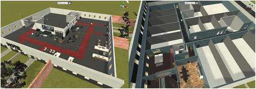
The virtual environment consisted of the interior and exterior of a simple hotel building (inspired by a real hotel). The ground floor lay within open space. An L-shaped foyer with staircases led to the first floor (). The first floor consisted of an L-shaped hallway connected to multiple hotel rooms (); room 212 was the only one accessible (with its door wide open). A story-based game approach was taken, including tasks that engaged the participants and prevented them from freely exploring the hotel interior. It was therefore possible to ensure that all the participants experienced the same conditions before evacuation, enabling them to form an initial mental representation of the building but excluding any environment familiarity factor that might have had a significant effect on navigation performance and decision-making (Hölscher et al., Citation2005; Li & Klippel, Citation2014, Citation2016).
Figure 1. Ground floor (left) and first floor (right) of the experimental environment.
Four environment variants were created, which differed in corridor width (visible area) and direction of the initial corridor segment before room 212. The direction (within the corridor) in which the participants approached the room was also changed. This provided four decision-making conditions at the initial decision point on the evacuation route (see ):
the participant entered room 212 via awidecorridor
evacuation signs indicated a narrow, straight-leading corridor (NS variant)
evacuation signs indicated a narrow right-leadingcorridor (NR variant)
the participant entered room 212 via a narrowcorridor
evacuation signs indicated a wide,straight-leading corridor (WS variant)
evacuation signs indicated a wideright-leading corridor (WR variant)
Figure 2. Point isovist analysis (McElhinney, Citation2018) of the four experimental conditions. The isovists were set in the direction of the corridors (decision-making options), which met at a right angle. The blue isovist always points to the wider corridor, the red to the narrower, and the purple shows where they overlap.

Since the majority of decisions about junctions have been found to remain consistent regardless of whether it was a right-hand or left-hand path choice (Emo, Citation2014), such variants where the evacuation signs would mark left-leading corridors, were omitted.
The decision point was a T-junction, approached by all participants during the evacuation phase from the door exiting room 212. At this point, they could exit either via a familiar corridor, used on the way up, or via a second corridor marked with evacuation signs. Both corridors were of equal length (27 m), which ensured equivalent evacuation routes in terms of distance and evacuation time. The differences in the spatial configuration of the decision points are quantified in using partial isovists calculated in Isovist 2.4 software (McElhinney, Citation2018). The sweep of the isovist was set to 110°, since this is the field of view available in the HTC Vive Pro headset.
2.2.2. Questionnaire
The questionnaire was presented online and was designed to assess the participants’ subjective observations and decisions made during the VR simulation. It was created through Google Forms and consisted of four sections: telepresence (questions 4–7 adapted from Kim & Biocca, Citation2006), orientation abilities, observation and usage of the evacuation plan and signage, and personal data. Participants answered single-choice questions and questions graded on a seven-point Likert scale.
2.3. Experimental design
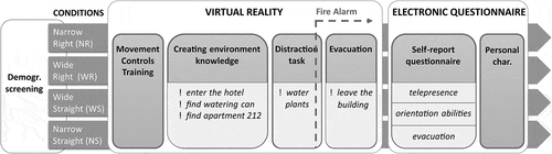
Two tools were deployed to collect the data concerning participants’ evacuation behavior: (a) original Toggle Toolkit (Ugwitz et al., Citation2021) with a Unity logger script to record the participants’ positions and interaction data, and (b) a retrospective, electronic self-report questionnaire exploring the participants’ experiences of the evacuation. A between-subjects experimental design, containing four environmental conditions, was applied. The first factor investigated was the environmental variant, which had four conditions (narrow-right, narrow-straight, wide-right, wide-straight). These were created and presented in virtual reality. The second factor was the level of compliance with the official (statutory) evacuation plan for individual evacuation, i.e., the extent to which participants noticed, considered and employed information provided by the evacuation plan. This was measured by means of a Likert scale (levels 1–7), in which 1 represented following the evacuation plan exclusively and 7 represented utterly ignoring it. The third factor reflected the self-reported ease of VR movement control, which has been identified as an important determinant of participant performance (Ugwitz et al., Citation2019); it has been established that this corresponds with gender and previous gaming experience; women tend to spend significantly more time on VR tasks than men (slower pace and more time spent exploring environments) and report more difficulties with movement controls (this may be associated with (lack of) previous gaming experience. (Ugwitz et al., Citation2019). Thus, the reported ease of VR movement controls was used as a performance predictor, since it represents a better explanatory variable than gaming experience or gender alone.
The experimental task measured the choice of retracing strategy, which was defined as using the same route to leave the building from room 212 as that taken to reach it. Since only two possible options were given for evacuation (the other was to choose the route marked with evacuation signs), the retracing strategy was coded either 1 (retracing used) or 0 (retracing not used) and derived from the logged position of the participant in the VR environment through the Unity logger script. Several other metrics were derived and served as supplementary measurements: time spent on the experimental task (total time from entry to the hotel building to exit) and total exit time (time needed to leave the hotel after activation of the fire alarm). The choice of door used to exit the building was also recorded. Previous evidence suggests that, in emergency situations, many people do not choose the nearest closed doors but rather those which are already open, regardless of their proximity (Haghani & Sarvi, Citation2016; Sime, Citation1983). Participants were also asked about their gaming experience (i.e. previous experience in playing computer games) and whether and when they took note of the evacuation signage in the building (upon entry to the building, for navigation to the room, or upon leaving the building, or not at all).
2.4. Procedure
Participants were invited to the experiment via social media. On arrival at the unit (Masaryk University, Faculty of Arts campus), participants signed informed consent forms and provided basic demographic information, including potential visual impairments or health limitations. They were informed that they could withdraw from the experiment at any time. They were introduced to the spatial navigation experiment in the virtual building. Participants were deliberately blinded to the real purpose of the experiment, i.e. an evacuation, to ensure that the scenario that was as realistic as possible. The entire experiment was fully computerized and the procedure did not differ between experimental groups. After calibration of the VR device, participants were given a short training session to familiarize them with the movement controls. They were then instructed to follow the text instructions sequentially presented in the virtual scene, which led them through the experimental task. After the VR simulation, all participants completed a questionnaire that investigated their subjective observations and decisions throughout the evacuation. A schematic diagram of the experiment’s procedure appears in .
Figure 3. Schematic diagram of the experimental procedure.
2.4.1. Task description
A sample video recording of the VR environment walkthrough is available at https://youtu.be/OUszEO5a5sg. When participants entered the virtual environment, they were positioned outside the hotel building. They were instructed to enter the hotel, then pick up a blue watering-can located near the staircase inside. This engaged the participants interactively with objects within VR. They were then instructed to find room 212, located on the first floor of the building. A clear evacuation plan was visible on the opposite wall upon entry to the room; however, participants were not prompted to study it in any particular manner. Once within the room, participants were instructed to water three withered plants located there. This task was designed as a distraction to engage participants before a fire alarm went off. This was activated precisely three seconds after the participant had watered any two (of the three) withered plants in the hotel room. The alarm consisted of an audible signal and the text instruction “leave the building”.
As participants exited the hotel room, they were required to choose an exit route from the hotel. The crucial decision point was positioned just outside room 212. A T-junction offered a familiar corridor, previously used by participants to reach the room, while the second, unfamiliar corridor was marked with evacuation signs. Both corridors led to a staircase, were of similar superficial appearance and met at a right angle (90 degrees). The spatial configuration of the junction was adjusted to represent the environmental conditions tested (). Upon reaching the ground floor, participants faced two similar exit doors (second decision point). The nearer door was closed (participants had previously used this door to enter the building); the other door, which participants had not previously used, was positioned farther away but was open. Once a door had been chosen, participants exited the building and the display faded to black with an announcement that the simulation had ended.
3. Results
3.1. Retracing suppression
The retracing data were analyzed by means of generalized linear models (GLM). Retracing behavior was the dependent variable (binomial; 1 = retracing, 0 = no retracing). Spatial configuration was included as a fixed factor with four conditions (the environmental variants). Noticing the evacuation plan and the use of its information in the evacuation process was also monitored and included as the second factor – adoption of the evacuation plan (measured on a Likert scale), see . A further important factor in this VR-based experiment design was the level of ease in the use of the movement controls. This was measured according to a Likert scale and adopted as a possible predictor of participant behavior. These three factors were incorporated into a generalized linear model executed by means of R-3.6.0 (R Core Team, Citation2017), lme4 (Bates, Mächler, Bolker & Walker, Citation2015) and lmerTest (Kuznetsova, Brockhoff & Christensen, Citation2017) packages. We obtained p-values by applying the Satterthwaite approximation for degrees of freedom. A generalized linear model for the retracing tendency indicated an adequate goodness of fit (Hosmer–Lemeshow Test: χ2(8, N = 72) = 6.56, p = .585) and disclosed significant effects that showed that the wide, straight corridor conditions suppressed the retracing strategy (β = – 2.13, z = – 1.97, p = .048; 95% CI [–4.55, – 0.20]) ass well as the wide right corridor (β = – 2.16, z = – 1.98, p = .048; 95% CI [–4.59, – 0.21]). The self-reported factor of observation and active use of the information provided in the evacuation plan was also found to suppress the retracing tendency significantly (β = 0.57, z = 3.73, p < .001; 95% CI [0.29, 0.90]). This suggests that participants who observed and studied the evacuation plan retraced significantly less frequently. Although 40.28% of participants explicitly stated that they saw the evacuation plan (NS 36.84%; NR 35.29%; WS 38.88%; WR 50.00%), most of them did not use the information provided to evacuate (M = 5.51, MIN = 1 (strongly agree), MAX = 7 (strongly disagree), SD = 2.33), see .
Figure 4. Predicted retracing values for each environmental variant according to observation of the evacuation plan and ease of use of the VR movement controls.
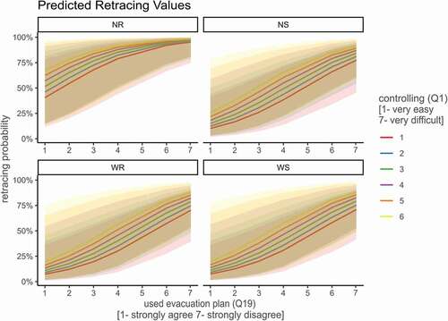
Figure 5. Predicted retracing values in terms of noticing evacuation signs.
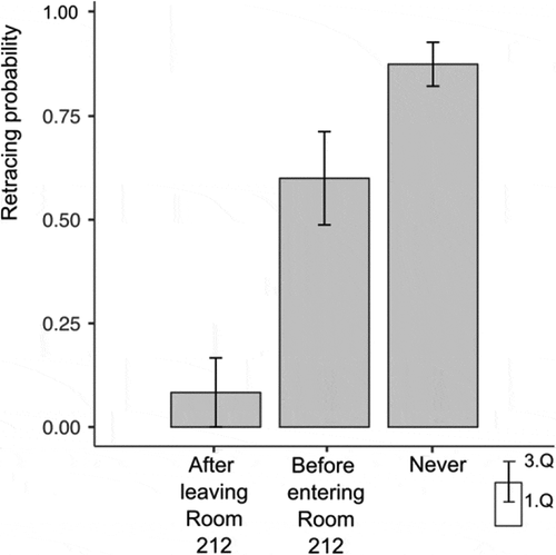
Figure 6. Visualization of ground floor exit door choice: retracing participants (left), participants following evacuation signs (right).
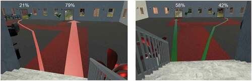
Figure 7. Visualization of the choice of evacuation route and waiting points, aggregated according to the environmental variants.
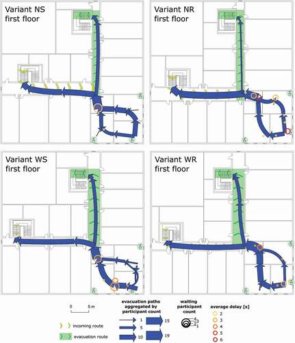
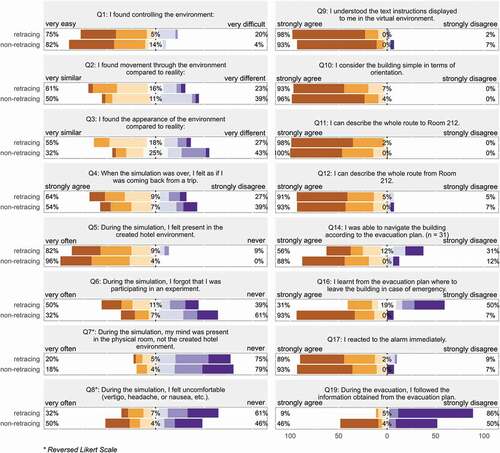
Figure 8. Summary of participant responses to the electronic questionnaire, aggregated according to their choice of evacuation route.
shows that the probability of choosing a retracing strategy was higher when evacuation signs marked the narrow right corridor, especially on the part of people who did not consider using the evacuation plan. A visualization of the aggregated paths traversed by participants on the first floor appears in .
The self-reported ease of use of the VR movement controls incorporated into the generalized linear model correlated with the total time spent on the experimental task (rs = 0.62, p < .001), exit time (rs = 0.513, p < .001), gaming experience and gender (rs = 0.45, p < .001) and completing the task (watering the third plant in the room) (rs = 0.29, p = .013).
3.2. Evacuation signage
According to variance analysis (Welch’s ANOVA), observation of the evacuation signage in the building significantly affected the choice of retracing strategy (F(2) = 31.5, p < .001; η2 = 0.369). Post-hoc tests were further used to disclose specific significant differences between individual factor levels. Specifically, participants who noticed the signs after leaving the room were significantly more likely to follow the evacuation route, and hence did not retrace as frequently as participants who only saw the statutory evacuation signage immediately upon entering the building (t(2) = – 3.69, p = .002), see . Participants who did not see the signage at all retraced significantly more frequently than people who observed it in the course of evacuation (t(2) = – 8.02, p < .001). No differences were found between the participants who noticed the signage immediately upon entering the building and participants who did not see it at all.
Frequency analysis of noticing evacuation signage revealed that the evacuating participants noticed signage significantly more frequently in the wide corridors than the narrow corridors (χ2(2, N = 72) = 6.43, p = .040) ().
Table 1. Frequencies of noticing evacuation signage in wide and narrow corridors
3.3. Exit doors
The data indicates that whether a door is open also plays a major role in choosing an exit from the building. Not relying on proximity alone, 27.78% of people used the open doors, which were apparently farther away, to exit the hotel building. The precise numbers of people exiting the building through each door appear in . In the self-report questionnaire, 55.56% of participants stated that they chose an exit door largely on the basis of proximity, 20.83% because the door was open, and 15.28% because of perceived ease in controlling VR movement.
4. Discussion
This study addressed retracing as an undesirable route choice strategy in the course of an evacuation process. A virtual simulation tool was deployed to explore whether the retracing strategy could be suppressed by the specific spatial configuration of the building. In particular, the effects of noticing the evacuation signs and evacuation plan upon retracing were noted. The authors predicted that evacuees would retrace less often if the marked evacuation corridor was straight, or wide, or a combination of both. It was also anticipated that noticing the evacuation signage would encourage any tendency on the part of the participants to follow the route marked.
Analysis of the data gathered revealed several significant effects with respect to the choice of evacuation strategy. Linear modeling showed that the spatial configuration of the building (i.e. manipulated experimental variants), had a significant effect on the choice of retracing strategy, where both the width and direction of the corridor were identified as important factors. The retracing strategy was most frequently employed in the building variant that marked the evacuation route as a narrow corridor to the right. Narrow right-angled corridors, as expected, immediately discouraged people from selecting them as evacuation routes. These findings correspond with existing studies (Bailenson et al., Citation2000; Meilinger et al., Citation2014). When the evacuation corridor was wide, the tendency to apply a retracing strategy decreased significantly (p = .048). This suggests that the particular spatial configuration of the building played an important role in the evacuation process. Greater corridor width introduced a larger visual area in a specific direction. Previous research has shown a positive correlation between larger visual area and the feeling of openness or exposure (Dosen & Ostwald, Citation2016). Assuming that people intuitively search for larger areas in which they are less likely to collide with objects or other evacuees, selecting a wider corridor constitutes a natural option for effective evacuation. Wider corridors are generally connected to the central areas of buildings and are more integrated, and are therefore more frequently used by first-time visitors (Hölscher et al., Citation2005; Li & Klippel, Citation2014, Citation2016). Participants who reported that they noticed and observed the evacuation plan also applied a retracing strategy significantly fewer times. This indicates that knowledge of the evacuation plan superseded spontaneous choice and led participants to follow the evacuation route. The results support the hypothesis that visual accessibility and wide, straight evacuation routes, together with observation of the evacuation plan, generally suppressed the participant tendencies to retrace incoming routes during evacuation.
Participants who noticed the evacuation signage in the building acted in significantly different fashions to those adopted by people who did not see the signs at all. As anticipated, participants failing to see the evacuation signs exited by the same way they entered the building significantly more frequently than participants who noticed and observed them during their evacuation. This suggests that once people had noticed the evacuation signage, they tended to use it. However, no significant differences were found between participants who saw the signage before entering the room and participants who did not notice it at all. This highlights an interesting aspect of the human tendency to prioritize currently-accessible information detected in the environment. People who noticed the signage only as they entered the room acted in a similar manner to those who did not see it at all. They may have downplayed the significance of evacuation signage information acquired before the evacuation in the light of environmental cues they acquired later. Wide corridors thus appeared to encourage the evacuees to use them, all the more so since they provided immediate and direct views of the evacuation signage. Frequency analysis supported this finding () and suggests that wide corridors are more suitable as evacuation routes. None of the mentioned parameters, however, completely eliminated participant choice to retrace incoming routes. It is highly probable that, regardless of idealized building layout, retracing behavior may still manifest during evacuation scenarios. We therefore consider it necessary that these probabilistic uncertainties in human decision-making and behavior be taken into account, for example, in the agent-based evacuation simulations that are used in the evacuation modeling that determines the maximum safe capacity of a building. Whatever the application, the findings of the present study indicate strongly that a building layout or an evacuation route that includes wider corridors with as few turns as possible can prevent the use of the retracing strategies that constitute undesirable behavior in emergency scenarios.
Self-reported ease of use of the VR movement controls was also explored in the generalized linear model. This factor correlated significantly with the total time spent on the experimental task and the time spent exiting the building, as well as with the gaming experience and sex of the participant. These results confirm gender differences already observed elsewhere, in which women have been shown to be slower, and report more problems, with VR movement controls (Ugwitz et al., Citation2019). However, these trends were probably more associated with greater gaming experience among males than with sex alone. Gaming experience may assist efficiency of movement within an artificial, game-like environment and may well have resulted in the observed differences in response times related to sex. Based on this observation, we recommend that future research conducted by means of VR environments should always consider the factor of UI control. It appears to have a significant impact on the overall performance of participants.
The way the participants herein chose to exit the hotel building seems to correspond with other studies (Haghani & Sarvi, Citation2016; Sime, Citation1983). Regardless of proximity, almost one-third of participants used the more distant, yet open, door to exit. This indicates that an open exit door can be a decision-making factor during an evacuation process, which once more emphasizes the significance of visual cues that are immediately observable in the environment.
The present study has its limitations. The number of participants was affected by experimental drop-out during the VR simulation. The self-report questionnaire used to collect information about participants’ experiences during the evacuation was retrospective, which may have resulted in information loss and/or bias. Nevertheless, the questionnaire was used because a conscious, think-aloud commentary on participant decisions and strategies during evacuation would affect strategies and potentially change the character of the entire experience. Future research should consider embedded VR eye-tracking (as in the techniques discussed by Juřík et al., Citation2019), which would permit objective measurement of participant sensorimotor activity. However, the experiment described herein confirmed that VR environments can offer valuable information about human behavior in evacuation scenarios.
Future research should focus on the demographic analysis of participants, development of UI, and virtual environments tailored to the needs of more complex spatial configurations. Interconnecting BIM, AI, eye-tracking and other emerging technologies would facilitate the creation of more precise parameters for recommendations related to building design or agent-based evacuation simulations (Penn & Turner, Citation2002). The opportunities to deploy eye-tracking, machine learning and brain-imaging/interfacing point to a “smart” future in which algorithms and computer models may add value to human work in evaluating, predicting, and proposing improvements in VR environments (Zhang, Hu, Che, Lin & Fang, Citation2018). Certain first steps in this novel approach were deliberately undertaken even in this relatively low-tech study. By using BIM data, implementing a continuous data logger, processing the data statistically and computing space-syntax metrics, the study herein provides an original insight into the viability of its experimental approach, the use of complex virtual environments and future directions for research in the field.
5. Conclusion
In the present study, a VR environment was used to explore factors that affected the choice of evacuation route in an emergency evacuation scenario. Retracing (i.e., choosing the same route to leave a building as the one used to enter it), was highlighted primary focus. The width and direction of corridors, together with noticing and observation of displayed evacuation plans were revealed as significant predictors in the choice of an evacuation route. Noticing evacuation signage was also found to have a strong effect on the choice of evacuation route, provided that it was seen during the evacuation phase, and not on the way to the room. Several gender-based differences in behavioral strategy during the emergency scenario were also identified, largely associated with control of movement within the VR environment.
Overall, the results presented in this investigation are consistent with previous studies that addressed real evacuations, and they support the viability of using virtual reality as a tool in the analysis of evacuation behavior. Additionally, virtual reality offers a number of advantages over more traditional studies conducted in real environments. Suggested future work could potentially engage modern complementary technologies, such as eye-tracking to record human sensorimotor activity.
Declarations of interest
None of the authors has any conflict of interest to declare.
Acknowledgments
The research was supported by the infrastructure Gray Lab, CEPCOS (Centre for Experimental Psychology and Cognitive Sciences), Masaryk University, Brno, Czech Republic. We would like to extend our thanks to the HUME Lab–Experimental Humanities Laboratory, Masaryk University, for providing us with the necessary machine time and equipment. Tony Long (Carsphairn, Scotland) helped work up the English.
Additional information
Funding
References
- Bailenson, J. N., Shum, M. S., & Uttal, D. H. (2000). The initial segment strategy: A heuristic for route selection. Memory & Cognition, 28(2), 306–318. doi:10.3758/bf03213808
- Bates, D., Mächler, M., Bolker, B., & Walker, S. (2015). Fitting linear mixed-effects models using lme4. Journal of Statistical Software, 67(1), 1–48. doi:10.18637/jss.v067.i01
- Benedikt, M. L. (1979). To take hold of space: Isovists and isovist fields. Environment and Planning. B, Planning & Design, 6(1), 47–65. doi:10.1068/b060047
- Benedikt, M. L., & McElhinney, S. (2019). Isovists and the metrics of architectural space. Conference: ACSA 2019: BLACK BOX: Articulating Architecture’s Core in the Post-Digital EraAt March 27-30, 2019. Pittsburgh.
- Cao, L., Lin, J., & Li, N. (2019). A virtual reality based study of indoor fire evacuation after active or passive spatial exploration. Computers in Human Behavior, 90, 37–45. doi:10.1016/j.chb.2018.08.041
- Cornwell, B. (2003). Bonded fatalities: Relational and ecological dimensions of a fire evacuation. The Sociological Quarterly, 44(4), 617–638. doi:10.1111/j.1533-8525.2003.tb00528.x
- Dalton, R. C. (2003). The secret is to follow your nose. Environment and Behavior, 35(1), 107–131. doi:10.1177/0013916502238867
- De Cock, L., Ooms, K., Van De Weghe, N., Vanhaeren, N., Pauwels, P., & De Maeyer, P. (2020). Identifying what constitutes complexity perception of decision points during indoor route guidance. International Journal of Geographical Information Science, 1–19. doi:10.1080/13658816.2020.1719109
- Dosen, A. S., & Ostwald, M. J. (2016). Lived space and geometric space: Comparing people’s perceptions of spatial enclosure and exposure with metric room properties and isovist measures. Architectural Science Review, 60(1), 62–77. doi:10.1080/00038628.2016.1235545
- Duckham, M., & Kulik, L. (2003). “Simplest” paths: Automated route selection for navigation. In International Conference on Spatial Information Theory, 169–185. Springer, Berlin, Heidelberg.
- Emo, B. (2014). Seeing the axial line: Evidence from wayfinding experiments. Behavioral Sciences, 4(3), 167–180. doi:10.3390/bs4030167
- Franz, G., & Wiener, J. M. (2005). Exploring isovist-based correlates of spatial behavior and experience. In A. Van Nes (Ed.), Space Syntax 5th International Symposium (pp. 503–517). Techne Press.
- Fuad, M. (2019, December 17). XR interaction toolkit preview package is here. Unity Technologies Blog. https://blogs.unity3d.com/2019/12/17/xr-interaction-toolkit-preview-package-is-here/
- Geyer, T., Bellamy, L. J., Max-Lino, R., Harrison, P. I., Bahrami, Z., & Modha, B. (1988). An evaluation of the effectiveness of the components of informative fire warning systems. In J. D. Sime (Ed.), Safety in the built environment (pp. 36–47). E. & F.N. Spon.
- Golledge, R. G. (1995). Path selection and route preference in human navigation: A progress report. Lecture Notes in Computer Science Spatial Information Theory A Theoretical Basis for GIS, 207–222. doi:10.1007/3-540-60392-1_14
- Golledge, R. G. (1999). Wayfinding behavior: Cognitive mapping and other spatial processes. Baltimore: Johns Hopkins Univ. Press.
- Haghani, M., & Sarvi, M. (2016). Human exit choice in crowded built environments: Investigating underlying behavioural differences between normal egress and emergency evacuations. Fire Safety Journal, 85, 1–9. doi:10.1016/j.firesaf.2016.07.003
- Hillier, B., & Iida, S. (2005). Network and psychological effects in urban movement. Spatial Information Theory Lecture Notes in Computer Science, 475–490. doi:10.1007/11556114_30
- Hillier, B., Leaman, A., Stansall, P., & Bedford, M. (1976). Space syntax. Environment and Planning. B, Planning & Design, 3(2), 147–185. doi:10.1068/b030147
- Hölscher, C., & Brösamle, M. (2007). Capturing indoor wayfinding strategies and differences in spatial knowledge with space syntax. 6th international space syntax symposium, Istanbul.
- Hölscher, C., Meilinger, T., Vrachliotis, G., Brösamle, M., & Knuaff, M. (2005). Finding the way inside: Linking architectural design analysis and cognitive processes. In C. Freksa, M. Knauff, B. Krieg-Brüchner, B. Nebel, & T. Barkowsky (Eds.), Spatial Cognition IV – Reasoning, action, interaction (pp. 103–121). Berlin: Springer-Verlag.
- Johnson, C. (2005). Lessons from the evacuation of the world trade centre, 9/11 2001 for the development of computer-based simulations. Cognition, Technology & Work, 7(4), 214–240. doi:10.1007/s10111-005-0009-5
- Juřík, V., Šafárová, K., & Šašinka, Č. (2019). Embodied cognition significance for the ecologically valid psychological research in virtual reality. In E. Maierová, L. Viktorová, M. Dolejš, & T. Dominik (Eds.), PhD existence 2019: Body and mind (pp. 374–382). Portál.
- Kim, T., & Biocca, F. (2006). Telepresence via television: Two dimensions of telepresence may have different connections to memory and persuasion. Journal of Computer-Mediated Communication, 3(2). doi:10.1111/j.1083-6101.1997.tb00073.x
- Kinateder, M., Ronchi, E., Nilsson, D., Kobes, M., Müller, M., Pauli, P., & Mühlberger, A. (2014). Virtual reality for fire evacuation research. In Proceedings of the 2014 Federated Conference on Computer Science and Information Systems, FedCSIS 2014, 313–321.doi:10.15439/2014f94
- Kurkjian, S., Ebbert, S., & Farragher, T. (2003, September 6). Behind the Rhode Island nightclub fire: Series of errors sealed crowd’s fate. The Boston Globe. http://archive.boston.com/news/packages/nightclub_fire/Series_of_errors_sealed_crowd_s_fate.shtml
- Kuznetsova, A., Brockhoff, P. B., & Christensen, R. H. B. (2017). lmerTest package: Tests in linear mixed effects models. Journal of Statistical Software, 82(13). doi:10.18637/jss.v082.i13
- Li, R., & Klippel, A. (2014). Wayfinding behaviors in complex buildings. Environment and Behavior, 46(6), 745–767. doi:10.1177/0013916514550243
- Li, R., & Klippel, A. (2016). Wayfinding behaviors in complex buildings: The impact of environmental legibility and familiarity. Environment and Behavior, 48(3), 482–510. doi:10.1177/0013916514550243
- Loomis, J. M., Blascovich, J. J., & Beall, A. C. (1999). Immersive virtual environment technology as a basic research tool in psychology. Behavior Research Methods, Instruments and Computers, 31(4), 557–564. doi:10.3758/bf03200735
- Maguire, E. A., Burgess, N., Donnett, J. G., Frackowiak, R. S., Frith, C. D., & O’Keefe, J. (1998). Knowing where and getting there: A human navigation network. Science, 280(5365), 921–924. doi:10.3758/bf03200735
- McElhinney, S. (2018). Isovist_2.2: A basic user guide. Isovist.org. https://isovists.org/user_guide/
- Meilinger, T., Frankenstein, J., & Bülthoff, H. H. (2014). When in doubt follow your nose—A wayfinding strategy. Frontiers in Psychology, 5, 1363. doi:10.3389/fpsyg.2014.01363
- Meilinger, T., Franz, G., & Bülthoff, H. H. (2012). From isovists via mental representations to behavior: First steps toward closing the causal chain. Environment and Planning. B, Planning & Design, 39(1), 48–62. doi:10.1068/b34048t
- Montello, D. R. (2007). The contribution of space syntax to a comprehensive theory of environmental psychology. Istanbul: 6 International Space Syntax Proceedings, IV, 1–12.
- Nenci, A. M., & Troffa, R. (2006). Space syntax in a wayfinding task. Cognitive Processing, 7(S1), 70–71. doi:10.1007/s10339-006-0071-9
- Paradis, M. A., Nicolas, T., Gaugne, R., Barreau, J. B., Auger, R., & Gouranton, V. (2019). making virtual archeology great again (without scientific compromise). ISPRS - International Archives of the Photogrammetry, Remote Sensing and Spatial Information Sciences, XLII-2/W15, XLII-2/W15, 879–886. doi:10.5194/isprs-archives-XLII-2-W15-879-2019
- Penn, A. (2003). Space syntax and spatial cognition: Or why the axial line? Environment and Behavior, 35(1), 30–65. doi:10.1177/0013916502238864
- Penn, A., & Turner, A. 2002. Space syntax based agent simulation. M. Schreckenberg & S. D. Sharma eds. Pedestrian and Evacuation Dynamics, pp. 99–114. Springer-Verlag.
- Proulx, G. (2001). Occupant behaviour and evacuation. In Proceedings of the 9th International Fire Protection Symposium, Munich, May 25-26, 2001, 219–232.
- Proulx, G., & Fahy, R. (1997). The time delay to start evacuation: Review of five case studies. Fire Safety Science, 5, 783–794. doi:10.3801/iafss.fss.5-783
- Proulx, G., & Sime, J. D. (1991). To prevent’ panic in an underground emergency: Why not tell people the truth? Fire Safety Science, 3, 843–852. https://doi:10.3801/IAFSS.FSS.3-843
- Quarantelli, E. L. (2000). The sociology of panic. Disaster Research Center.
- R Core Team (2017). R: A language and environment for statistical computing. R Foundation for Statistical Computing. https://www.R-project.org/
- Ratti, C. (2004). Space syntax: Some inconsistencies. Environment and Planning. B, Planning & Design, 31(4), 487–499. doi:10.1068/b3019
- Sime, J. D. (1983). Affiliative behaviour during escape to building exits. Journal of Environmental Psychology, 3(1), 21–41. doi:10.1016/s0272-4944(83)80019-x
- Smith, S., & Ericson, E. (2009). Using immersive game-based virtual reality to teach fire-safety skills to children. Virtual Reality, 13(2), 87–99. doi:10.1007/s10055-009-0113-6
- Ugwitz, P., Juřík, V., Herman, L., Stachoň, Z., Kubíček, P., & Šašinka, Č. (2019). Spatial analysis of navigation in virtual geographic environments. Applied Sciences, 9(9), 1873. doi:10.3390/app9091873
- Ugwitz, P., Šašinková, A., Šašinka, Č., Stachoň, Z., & Juřík, V. (2021). Toggle toolkit: A tool for conducting experiments in unity virtual environments. Behavior Research Methods. doi:10.3758/s13428-020-01510-4
- Wiener, J. M., Büchner, S. J., & Hölscher, C. (2009). Taxonomy of human wayfinding tasks: A knowledge-based approach. Spatial Cognition and Computation, 9(2), 152–165. doi:10.1080/13875860902906496
- Wood, P. G. (1972). The behaviour of people in fires. Fire Research Notes, 953.
- Xie, H., Filippidis, L., Galea, E. R., Blackshields, D., & Lawrence, P. J. (2011). Experimental analysis of the effectiveness of emergency signage and its implementation in evacuation simulation. Fire and Materials, 36(5–6), 367–382. doi:10.1002/fam.1095
- Zhang, F., Hu, M., Che, W., Lin, H., & Fang, C. (2018). Framework for virtual cognitive experiment in virtual geographic environments. ISPRS International Journal of Geo-Information, 7(1), 36. doi:10.3390/ijgi7010036