Abstract
This paper reviews a century of geographical contributions at the University of Glasgow to the development of glacial geomorphology. Significant advances were made from the 1960s, when geographers and topographic scientists began to combine geomorphic and survey expertise in accurately charting spatial and temporal changes in Icelandic glacier snouts and proglacial landforms, providing modern analogues for process-form models (the first glacial landsystems model) and a methodological avenue for quantification. Subsequent expeditions and research projects, involving a range of Glasgow academics, doctoral students and undergraduates, often in collaboration with researchers based elsewhere, have led to numerous conceptual and methodological refinements – and on occasion significant recasting – of this pioneering work. A detailed review is provided of these many contributions, seeking to elaborate their significance against a wider horizon of inquiry into glaciated landscapes, past and present.
Introduction
Glacial geomorphology became a core research theme at Glasgow in the 1960s following the appointment of R.J. Price fresh from his overseas research in North America. British glacial geomorphology at this time was undergoing a revolution, spearheaded by J. Brian Sissons at Edinburgh (see Ballantyne & Gray, Citation1984 for a review) and influenced by the conceptual advances forged by the Scandinavian researchers such as Mannerfelt, Hjulström, Hoppe and Östrem based upon their experiences of modern analogues. In North America also, glacial geomorphologists were advancing their knowledge of process-form relationships using observations around modern glacier snouts and utilizing the expanding collection of aerial photographs of ancient and freshly deglaciated terrains (see Evans Citation2008 for historical review). Glacial geomorphological research in Britain had long suffered from a dearth of modern analogue studies, but this was about to change and Price's experience in North America was to ensure that he figured prominently in the quest for modern analogues (Price, Citation1964, Citation1965, Citation1966). Consequently, the Geography Department at Glasgow was to play an important role in that new emphasis, a role for which it was well endowed when glacial geomorphology and topographic science were brought together.
In 1990, my own appointment at Glasgow as Rob Price's successor gave me the opportunity to re-invigorate the application of modern analogues to palaeoglaciology. My background was uncannily similar, having completed a MSc and PhD in glacierized terrains in northern Canada and therefore versed in the North American tradition of glacial landform and sediment mapping. The significance of becoming a glacial geomorphologist in Glasgow was not lost on me, because it was here in 1840, at the meeting of the British Association, that Agassiz delivered one of his paradigm shifting presentations on the glaciation of northern Europe. This was followed by the first glacial field trip in Britain (Davies, Citation1969; Cunningham, Citation1990), specifically to the Highlands, after which William Buckland and then Charles Lyell were persuaded that ancient glaciers had impacted upon the British Isles. This was achieved by recourse to modern analogues; Agassiz had the perfect analogue for the Parallel Roads of Glen Roy in the shape of the glacial lake shorelines of the Marjeelensee in Switzerland.
This paper provides a personal overview of the history of study of glaciers and glaciation at the University of Glasgow, delivered initially by Geologists but subsequently through the Geography Department. I have adopted a thematic approach but one that also provides a chronological perspective, allowing us to appreciate the contribution of Glasgow to historical developments in glacial research. Hence, the paper tracks the establishment of glacial geomorphology with the appointment of Price in the 1960s and then reviews the alliance of geomorphology and topographic science that culminated in the BreiÐamerkurjökull project. This leads us on to the subject of research expeditions, the most recent of which have resulted in the extension of the BreiÐamerkurjökull record and the production of numerous glacier foreland maps. The 1990s and early 2000s are then viewed as an era of glacial landsystems expansion and refinement, when glacial geomorphology and sedimentology, conducted around modern glacier margins, provided modern analogues for palaeoglaciological reconstruction. This is demonstrated with reference to work on the Loch Lomond Readvance and the British-Irish Ice Sheet, themes that have their foundations in earlier work by Glasgow researchers. More recent contributions, such as process glaciology and cosmogenic nuclide dating of glacial landscape evolution are then reviewed before an annex paper presents maps dating to 1945, 1965 and 1998 of the Icelandic glacier Fjallsjökull. This new contribution combines the previously unpublished mapping of two separate generations of glacial researchers and marks the celebration of a century of Glasgow Geography; it is a tribute to the unique flavour of glacial research that emerged from the alliance of topographic survey and glacial geomorphology at Glasgow.
Early Contributions and the Research on Alaskan Glacier Forelands
The earliest glacial contributions from the University of Glasgow emerged from the Geology Department, specifically from J.W. Gregory, who delivered a variety of regional assessments of glacial features (e.g. Gregory, Citation1907, 1911–1912, Citation1913a, Citation1914, Citation1915a & b, Citation1922, Citation1926a, Citation1928; Renwick & Gregory, Citation1909) as well as some wider conceptual offerings that were both ambitious and in no small part controversial (e.g. Gregory, Citation1912a & b, Citation1913b, Citation1926b). For example, Gregory's (Citation1926b) offering on aeolian drumlin formation based upon the observation that wind-stressed trees were similarly orientated was somewhat far-fetched and certainly logically flawed (see Evans Citation2008 for discussion), but his impressive compendium on The Nature and Origin of Fiords (Gregory, Citation1913b) was far-sighted in that it highlighted the role of geological structure in the production of mega-scale glacial erosion forms, a concept that we continue to discover is significant in the evolution of glaciated landscapes (cf. Gregory, Citation1912b). Gregory also seems to have been influential in the differentiation of eskers and kames in Britain, whereby his 1912(a) paper adopted emerging European views that the term esker be applied to ice-walled tunnel deposits. More prescient was Gregory's early collaborative work on modern glacier margins in Svalbard before he came to Glasgow. British contributions to knowledge on contemporary glacier margins were sparse, but Garwood and Gregory (Citation1898), in explaining the process of debris entrainment and deposition and proglacial thrusting by an advancing sub-polar glacier, provided probably the earliest description of what is now known as the apron entrainment process (cf. Evans, Citation1989). This early example of modern process-form analogue was to later become the hallmark of Glasgow glacial geomorphology.
The earliest links between Geography and cold regions research were manifest in the activities of geologist Alexander Stevens who, after working with Gregory became a lecturer in, and then in 1947 Chair of, the Geography Department. Stevens took part in Shackleton's famous Imperial Antarctic Expedition of 1914–17 as chief scientist (see obituary by Fairhurst, Citation1966). After Stevens had been rescued and returned from the Shackleton expedition, he served with the Royal Engineers as a surveyor for the last two years of the First World War.
The first Glasgow Geography Department contribution to glacial geomorphology was delivered by Jane Soons in a PhD that featured early applications of Mannerfelt's principles of glacial meltwater erosion (see Evans, Citation2004, Citation2008 for a review) to the interpretation of the drainage evolution of the Ochil Hills (Soons, Citation1958a & b, Citation1960). This was a paradigm, often referred to as the ‘Scandinavian School’, that was reflected in the predominant glacial research directions in the UK in the early 1960s, and it was in deglacial meltwater signatures that Price undertook his PhD research (Price, Citation1961) under the supervision of the prime mover in this arena, Sissons at Edinburgh from 1958–61; Price was in fact Sissons' first postgraduate student.
After appointments as Assistant Professor at the University of Oklahoma from 1961–2 and then the University of Oregon from 1962–63, Price was appointed as the first glacial geomorphologist at Glasgow in 1963. His experience with modern glacier snouts was afforded by his appointment by R.P. Goldthwait as Research Director for the Ohio State Institute of Polar Studies 1962 field season in Glacier Bay. It was at this time that Price became acquainted with Roy Welch (a graduate student at Oklahoma) through his appointment as field assistant. Price and Welch together undertook studies of changes in proglacial landforms (Price, Citation1964, Citation1965; Welch Citation1964), an area of research that was developed once Price had moved to Glasgow. The Alaska work, specifically on the foreland of the Casement Glacier, clearly influenced the direction of later Glasgow-based research in Iceland. It made use of ground photographs and observations from 1907 and then aerial photographs from the 1940s and 1963 to compile maps of changing glacier margins and evolving glacial landforms, particularly the prominent esker networks which Price had meticulously mapped by plane table methods.
The Emergence of the Glacial Geomorphology and Surveying Alliance
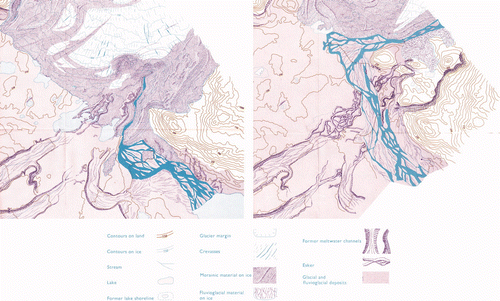
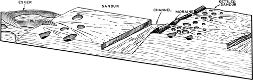
The invaluable alliance of accurate surveying techniques and aerial photograph interpretation in glacial geomorphological research was ably demonstrated when Price introduced his Casement Glacier work to Gordon Petrie, his new colleague at Glasgow. The result was the application of photogrammetry to the problem of quantification of landform evolution, communicated in papers by Petrie and Price (Citation1966) and Price (Citation1966), the former having been presented at an international symposium on glacier mapping in Canada in 1965 and accompanied by Glasgow's first glacier foreland maps of the Casement Glacier based upon 1948 and 1963 aerial photography (). Still significant to this day are the observations that the melt-out of glacier ice had gradually lowered eskers and associated glacifluvial outwash onto the substrate (Supp. Figure S1)1, demonstrating that large areas of the glacier snout had been buried by outwash during recession and that eskers had been emplaced englacially, not subglacially as had been traditionally assumed. This significant contribution to glacial geomorphology was the foundation for the next seminal stage of research on glacier forelands at Glasgow, one that was to fully engage the rich vein of expertise in Topographic Science and take ground survey to a much higher level of precision.
Figure 1. Extracts from the 1948 (left) and 1963 (right) maps of the Casement Glacier foreland, showing the development of the esker network from debris-covered glacier ice and the drastic changes in the proglacial drainage channels (from Petrie & Price Citation1966). A high quality version of this map is available online at: http:///www.informaworld.com/RSGJ
The BreiÐamerkurjökull Project 1964–67
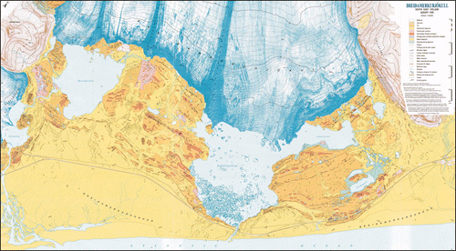
BreiÐamerkurjökull, the largest piedmont lobe of the southeastern margin of Vatnajökull, Iceland, is not only the most mapped glacial foreland in the world, but has also been the target of many ground-breaking glacial research projects over the last thirty years, including the seminal subglacial deformation experiments of G.S. Boulton and co-workers (e.g. Boulton & Hindmarsh, Citation1987; Benn, Citation1995; Boulton et al., 2001; see Evans & Twigg, Citation2002 for a review). The glacier and its emerging proglacial geomorphology have thereby provided glacial researchers with an historical record of cryospheric responses to climate change. The first accurate survey was a 1:100,000 scale map by the Danish General Staff in 1903, and a later map for 1951 was produced by the University of Durham. After their successes in Alaska, Price and Petrie selected BreiÐamerkurjökull for intensive survey for two important reasons (Price, Citation1968): (1) the glacier foreland contained a wealth of glacial landforms suitable for geomorphological research (e.g. Okko, Citation1955); and (2) the glacier had been photographed with a survey camera in 1945 by the US Army in the production of a series of 1:250,000 and 1:50,000 scale maps of Iceland. Some later aerial photography was also available for 1960/61 and 1964, but it was Price and Petrie's intention to obtain new photographs and thereby facilitate assessments of glaciological and geomorphological changes.
The majority of the research output from the BreiÐamerkurjökull project was reported in two University of Glasgow PhD theses written by Roy Welch (Citation1967) and Phil Howarth (Citation1968), based on the west and east halves of the foreland respectively. Subsequent publications from these theses and from other output by the research team contributed significantly to the development of process-form models in glacial research (Clayton & Moran, Citation1974). For BreiÐamerkurjökull specifically it resulted in the production of a sequence of maps charting snout recession since the Little Ice Age maximum. A composite map comprising the west half of the glacier in 1937 and the east half in 1931 was reproduced by Price and Howarth (Citation1970) based upon published evidence. They also reproduced maps for 1960/61 and 1964 based upon the available aerial photographs. It was the new mapping based on 1965 aerial photography, however, that became the instantly recognizable signature of the Glasgow glacial research programme, because it combined geomorphic and survey expertise to chart accurately the evolution of a glacier snout and its emerging foreland, and it was produced using the most advanced photogrammetric and cartographic expertise of the time.
Securing aerial photography in the summer of 1965 was the result of a fortuitous coincidence. The Icelandic Roads Department were considering the construction of a road bridge over the Jokulsa, the short but deep and swift river that joins the proglacial lake Jokulsarlon to the sea, and this required new aerial photography. The new photography was financed by the Icelandic Roads Department, Landmælingar Islands and the Glasgow Geography Department, and the opportunity was taken to experiment with different types of film including panchromatic, colour, false colour and infra red (Welch, Citation1966, Citation1968). Additionally, Petrie and Welch negotiated with Hunting Surveys for the loan of a Wild RC5a aerial camera. The ground survey control was established with a thoroughness that became the hallmark of the Glasgow Topographic Science team. From two base camps, one at the old Durham (Newcastle) University BreiÐa Hut (Lister, Citation1953) in the west and one below the Brennholda Alda moraine in the east (Supp. Figure S2), the survey team precisely located 50 ground control points that would be visible on the aerial photographs. Marked by cloth targets, the control points were marked for posterity by steel pins and in some cases by rock cairns. In the days before GPS, the ground control system was established by triangulation using the few points of known altitude in the area.
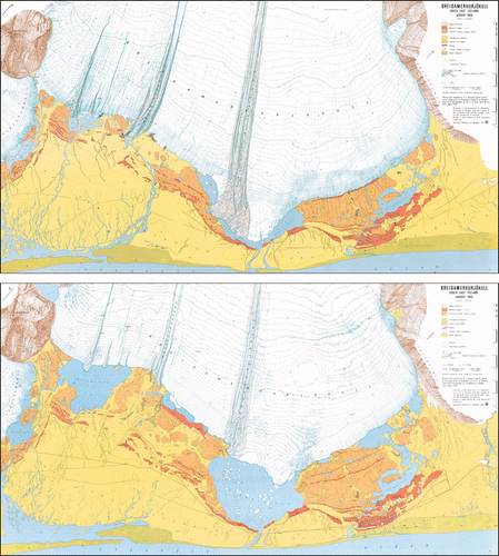
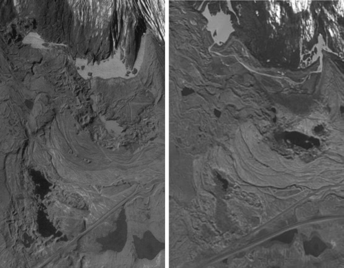
The meticulous and painstaking photogrammetry and mapping by Welch (Citation1967) and Howarth (Citation1968) delivered a 1965 map of the glacier snout and its foreland at a scale of 1:15,000. Howarth and Welch (Citation1969 a & b) then produced 1:30,000 colour maps of the snout and foreland for 1965 and 1945, the latter based on the US Army Air Force (USAAF) photography (). The neighbouring glacier Fjallsjökull and its foreland appear partially on the various maps of BreiÐamerkurjökull. Separate 1945 and 1965 maps of Fjallsjökull were produced at the same time as the BreiÐamerkurjökull maps but never published (see Annex). At the disposal of Welch and Howarth during the preparation of the BreiÐamerkurjökull maps was the considerable expertise of a strong Topographic Science team, including Petrie, John Keates OBE and Barry Methley.
Figure 2. Thumbnail style reproductions of the BreiÐamerkurjökull 1945 (upper) and 1965 (lower) maps originally produced at 1:30,000 scale (Howarth & Welch Citation1969a, b). A high quality version of this map is available online at: http:///www.informaworld.com/RSGJ
As surveying and cartographic exercises, the BreiÐamerkurjökull maps were significant contributions in their own right. Additionally they provided the opportunity to study spatial and temporal changes in both the glacier snout and the proglacial landforms, contributing valuable modern analogues to the process-form models that were being increasingly employed in Quaternary palaeoglaciological reconstructions. This was summarized by Welch and Howarth (Citation1968) with illustrations of changes in eskers, kame and kettle topography, ice-dammed lakes and coastal features from 1945–1965. Particularly instructive were the morphological changes taking place in the esker networks on the BreiÐamerkurjökull foreland (cf. Howarth, Citation1971; Price, Citation1982; Supp. Figure S3), where simple ridges were being lowered over time and complex anabranched systems began emerging from initially flat ice-contact fans. This demonstrated that large parts of the BreiÐamerkurjökull eskers were not subglacial, as conventional wisdom would dictate, but rather were englacial. The continued evolution of the BreiÐamerkurjökull eskers would be later elucidated after another 20 years of landscape development by Evans and Twigg (Citation2002; see below).
Further evidence of the evolution of glacifluvial features on an historical timescale at BreiÐamerkurjökull was provided through comparison of the various maps produced between 1904 and 1965 (Price & Howarth, Citation1970). The trends were very instructive, as they demonstrated a change in drainage pattern from an early phase of proglacial outwash fans carrying meltwater directly away from the snout to a system that drained ice margin-parallel and decanted into a series of proglacial lakes (Howarth & Price, Citation1969), a sequence of events that bore striking resemblance to changes at the Casement Glacier charted by Price (Citation1964) and Petrie and Price (Citation1966). This later phase of drainage was topographically constrained by the ice-contact slopes of the early outwash fans, which formed significant barriers to proglacial drainage once the snout had receded from them around 1945. During this later phase of drainage large parts of the receding snout were buried by prograding outwash, leading to an increase in kame and kettle topography. The impacts of one catastrophic depositional event were recorded in time slices in the aerial photography, when an ice-dammed lake on the west side of the snout dumped large quantities of glacifluvial sediment over glacier ice; the geomorphic signatures of this event were surveyed with unprecedented accuracy by the Glasgow research team (Price, Citation1971).
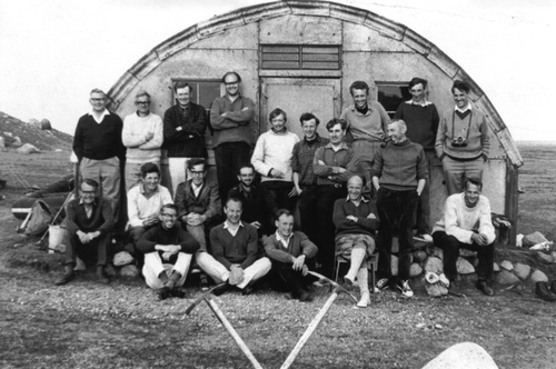
The accomplishments of the BreiÐamerkurjökull project were celebrated in the summer of 1968 when R.J. Price organized the first overseas field meeting of the Quaternary Field Study Group (later the Quaternary Research Association; ). The substantial field guide (Price & Howarth, Citation1968) produced for this meeting was a compilation of some of the most significant research findings and was designed to communicate the value of modern analogues to an audience whose regular business was Quaternary reconstructions.
Figure 3. The participants of the Quaternary Field Study Group (latterly QRA) at the Breida Hut during the 1968 field meeting. Back row standing on benches, from left to right: L. Penny, W. Thorns, R.J. Rice, R. Johnson, G. Saunders, A. Orchard, E. Brooks. Middle row from left to right: K. Clayton, T. Finch, G.F. Mitchell, R.J. Price, (seated), D. Mottershead, P. Howarth, P. Triccas and unnamed (standing). Front row from left to right: C. Embleton, E.A. Francis, J.G. Smart, D. Peacock, J. Thornes
The establishment of the ground survey control network at BreiÐamerkurjökull and the compilation of the map sequence of the snout and foreland are lasting legacies, because they form the foundation of an ongoing long term monitoring project. Glacial geomorphology had also been provided with a methodological avenue for quantification (Price, Citation1980, Citation1982). The bi-products of the BreiÐamerkurjökull project were the studies of glacial landforms in their pristine state. For example, in addition to the charting of landform development using aerial photographs of different age, site-specific work led to seminal work on annual push moraines (Price, Citation1970; Boulton, Citation1986) and the first glacial landsystems model, specifically for active temperate glaciers (Price, Citation1969). A compilation of the knowledge gleaned from modern glacier margins in Alaska and Iceland was published in the Department of Geography's first glacial textbook by Price (Citation1973), entitled Glacial and Fluvioglacial Landforms. Price (Citation1983) later went on to apply his modern analogues to reconstructions of Quaternary glaciation in Scotland in his book Scotland's Environment During the Last 30,000 Years.
After the completion of the BreiÐamerkerjökull and Fjallsjökull maps, throughout the late 1960s and the 1970s, Petrie went on to carry out a series of glacier mapping projects in the Swiss Alps (Supp. Figure S4). Over a period of years, the mapping of the Brenay (Citation1968), Ottema (1968), Trient (1971), Alpetli (1973), Kanderfirn (1973), Tsidjiore Nouve (1977) and Arolla (1977) glaciers was carried out in close cooperation with Dr. Hans Rothlisberger of the Swiss Glacier Commission based at the Federal Technical University (ETH) in Zurich and, in the case of the last two of these Swiss glaciers, with the Geography Department at the University of Southampton. Unusual at the time was the behaviour of these glaciers in that they were advancing, not retreating like all the other glaciers in the region. Rothlisberger arranged and financed the use of the Pilatus Porter aircraft of the Swiss Landestopographie to take aerial photographs with a Wild metric camera once ground survey control points had been triangulated and marked. The stereo-plotting and the cartographic work were undertaken during the winter in Glasgow and coloured maps were then duly delivered to Rothlisberger.
A further cooperation with Gunnar Østrem of the Norges Vassdragsvesen during the same period also saw the successful completion of the mapping of the outlet glaciers from the Jostedalsbre ice-sheet in the Briksdal Valley in West Norway in 1969 by Petrie and of Smorstabreen on the Jotunheimen plateau in 1975 by Methley. This was undertaken with the collaboration of the photogrammetrists at Norges Geografisk Oppmaling, some of whom had been fellow post-graduate students of Petrie (including his Norwegian wife) at ITC in Delft in the Netherlands. The mapping of the Norwegian glaciers was logistically a very much tougher proposition than the projects in Iceland and Switzerland with large mapping targets and poor weather conditions for aerial photography. As a result, only a single map was produced in each case rather than the sequences produced in Iceland and Switzerland.
The Research Expeditions
In the late 1950s and early 1960s glacier research expeditions were organized by physical geographer Cyril Halstead, specifically to the mountain icefields of Vindheimajökull in Iceland and Jotenheimen in Norway. The participation of undergraduate and postgraduate students in departmental research on glacial geomorphology was initiated in penny numbers during the BreiÐamerkurjökull project and then expanded during the later Swiss mapping projects. The sequential maps of the Swiss glaciers were accomplished by Gordon Petrie and the whole Topographic Science Honours class, with the assistance of volunteers from the Level Two class. The Honours students spent three-and-half weeks at the glacier snout being surveyed that year as part of their final year mapping project. Equipment was transported by lorry from Glasgow and a tented base camp was established, from which ground control points were triangulated and marked for aerial photography.
Having been involved in providing access for undergraduates to research expeditions in North America, albeit in small numbers as field assistants, I arrived in Glasgow in 1990 keen to deliver research-led teaching through expeditions. Expeditions to Iceland became a regular feature but groups also visited Svalbard, the Himalaya, Norway and the Canadian Rockies. Over the years this inevitably resulted in the development of young researchers who later went on to do postgraduate degrees and in some cases the joint publication of good field data. highlights the expedition locations, dates and student numbers over the period 1991–2004 (; Supp. Figure S5), after which I moved to Durham. Each expedition delivered numerous dissertations on glacial themes, including glacier-climate relationships, glacial geomorphology, relative age dating and vegetation succession, glacier hydrology, paraglacial processes and forms and glacial sedimentology. Staff research output during these expeditions is highlighted in following sections, but it is worth noting here that joint staff-student publications also accrued from these endeavours on topics such as relative age dating of glacial landforms (Evans et al., Citation1994; Citation1999a), glacial sedimentology (Evans et al., Citation1999b) and process glaciology (Swift et al., Citation2006). In 1998 the expeditions became joint university affairs, as the surveying expertise of Dave Twigg and his students from Loughborough University was combined with glacial specialist skills from Glasgow, allowing the map making tradition to be resurrected.
Table 1 . Glasgow Geography Research Expeditions 1991–2004
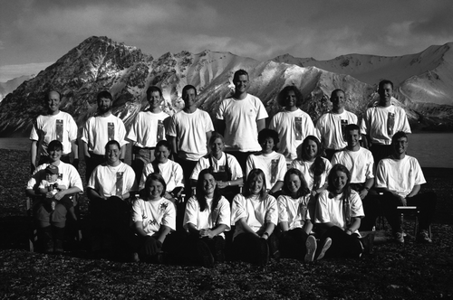
Figure 4. Team photograph of expedition to St Jonsfjorden, Svalbard in 1996
A special expedition was jointly run by the Glasgow department in December 2002–January 2003 as part of the centenary celebrations of the accomplishments of William Speirs Bruce and his Scotia Expedition to the sub-Antarctic islands. During this expedition my glacial expertise was combined with the coastal interests of Jim Hansom to contribute to the reconstruction of the glacial history of the central east coast of South Georgia (see Bentley et al., Citation2007). Similar glacial and sea level studies had been previously conducted in North Norway (Evans et al., Citation2002) and Svalbard (Evans & Rea, Citation2005).
BreiÐamerkurjökull Revisited (1998)
Aerial photographs of BreiÐamerkurjökull taken in 1980 were used by Price (Citation1982) to produce a small scale map of the glacier and its foreland in order to demonstrate the pattern of snout recession. Additionally, a new 1:30,000 colour version featuring the more detailed geomorphology was started but never completed, and it was not until 1998 that BreiÐamerkurjökull was mapped again in detail. The year 1998 was a significant one for Glasgow glacial research in that the department's second glacial textbook, Glaciers and Glaciation, was published (Benn & Evans, Citation1998) and BreiÐamerkurjökull was once again the target of a survey and mapping project. A substantial team of 26 descended on the BreiÐa Hut that summer to undertake glacial geomorphological research and to set out survey markers for new aerial photographs to be flown by Landmælingar Islands. The surveying this time was undertaken by Twigg, from the Civil and Building Engineering Department at Loughborough University (Supp. Figure S6), because he had previous experience in mapping in glaciated terrain. A total of 54 ground control markers were surveyed relative to a known station in the Icelandic GPS network using Leica single-frequency GPS receivers, an altogether speedier procedure to that in 1965 thanks to technological advances. A fitting tribute to the efforts of the 1965 survey team was the fact that every survey marker but one on the glacier foreland was re-located, the missing marker having been eroded by the sea. The 1998 map (Evans & Twigg, Citation2000; ) was produced at a scale of 1:30,000 and designed for ease of comparison with the 1945 and 1965 maps. The three maps were published together with an exhaustive treatment of the glacier recession history, glacial geomorphology and glacial sedimentology by Evans and Twigg (Citation2002) in an effort to update and refine Price's (1969) landsystem model (see below).
Figure 5. Thumbnail style reproduction of the BreiÐamerkurjökull 1998 map originally produced at 1:30,000 scale (Evans & Twigg Citation2000). A high quality version of this map is available online at: http:///www.informaworld.com/RSGJ
The 1998 survey facilitated the documentation of another stage of landform evolution 20 years on from the work of Welch and Howarth (Citation1968). For example, the BreiÐamerkurjökull eskers, that in 1965 were clearly being lowered over time and getting more complex, had by 1998 emerged from the chaotically downwasting surfaces of ice-cored outwash (Evans & Twigg, Citation2002). They had developed into a ‘fan-shaped’ pattern of ridges emanating from a single large ridge at the apex of the ‘fan’ (Supp. Figure S7). Although Evans and Twigg (Citation2002) used this evidence to question the existence of a stable subglacial drainage network, Boulton et al. (Citation2007a & b) later proposed that the esker patterns record the locations of sediment-filled supraglacial channels that had developed on the outer toe of the glacier snout beyond the main stream portal, a concept that it would be interesting now to independently assess using the Casement Glacier. Another 20 years of melting will inevitably reveal the final landform product, allowing glacial geomorphologists to appreciate the complex pathways of morphological change around active temperate glacier snouts.
If every research environment has an icon, then the BreiÐamerkurjökull maps must be Glasgow's glacial geomorphology icon (Leading Edge, Citation2001). They inextricably link the research of several generations of glacial geomorphologist and geodesist through a common scientific value, the appreciation of modern analogues and their role in palaeoglaciological reconstruction.
Glacial Landsystems
A benchmark paper in glacial geomorphology was that of Price (Citation1969), for no less a reason than it compiled the results of the BreiÐamerkurjökull project in the first glacial landsystems paper (Evans, Citation2004). Although the landsystems concept had been around for some time, it was not used widely in glaciated terrain until the 1980's (see Evans, Citation2003a, for a review), and hence the term ‘landsystem’ is not used by Price (Citation1969). A landsystem is a terrain that can be differentiated by recurrent patterns in both surface forms and underlying sediments and then classified according to the processes responsible for its genesis. This linkage of process and form had been identified for lowland glaciation, especially in North America, and was summarized in Clayton and Moran's (Citation1974) seminal work. Nevertheless, Price's paper conveyed a process-form model that expanded and effectively validated the ergodic approach through direct measurement and mapping of glacial processes (). It therefore constitutes the first modern glacial landsystem analogue, one that is pertinent to active temperate glaciers. The later subglacial experiments carried out by Boulton and co-workers at BreiÐamerkurjökull allowed us to expand the process-form relationships in the landsystem model to include the formation of tills and streamlined bedforms such as flutings and drumlins (cf. Boulton, Citation1987; Evans & Twigg, Citation2002; Supp. Figure S8) and to link sub-marginal till deformation with push moraine formation (cf. Price, Citation1970; Sharp, Citation1984; Evans & Hiemstra, Citation2005).
Figure 6. Price's (Citation1969) original block diagram portraying the juxtaposition of landforms typical of deposition around the margins of temperate lowland glaciers and based on the BreiÐamerkurjökull surveys
The refinement of the BreiÐamerkurjökull active temperate glacial landsystem was part of a broader mission at Glasgow to identify a range of landsystems for glaciated terrain, expanding the scheme initially published by Eyles (Citation1983). Stemming from this, the Glacial Landsystems Working Group (GLWG; affectionately known as ‘Glug’) was founded in Glasgow in 1998, a special issue of Sedimentary Geology was dedicated to ice-marginal landsystems in 2002 (Evans & Russell, Citation2002), and an edited book called Glacial Landsystems (Evans, Citation2003a) constituted the third glacial geomorphology textbook to emerge from the department. In the spirit of the BreiÐamerkurjökull project, the landsystems research theme was founded in modern analogues, and stemmed from earlier research in the Canadian High Arctic where palaeoglaciological reconstructions were guided by the landsystems of adjacent glacierized catchments (Evans, Citation1990a & b; Ó Cofaigh et al., Citation1999, 2003; England et al., Citation2000, 2004). Modern analogues were subsequently identified for plateau icefields (Rea et al., Citation1998; Rea & Evans, Citation2003), sub-polar glacier margins (Ó Cofaigh et al., 1999, 2003), sub-polar ice sheet margins (Dyke & Evans, Citation2003), debris-charged glaciers (Spedding & Evans, Citation2002; Swift et al., Citation2006) and surging glaciers (Evans & Rea, Citation1999, 2003). These models were then applied to palaeoglaciological reconstructions in a variety of settings ranging from ice sheet beds (Evans, Citation1996, Citation2000a; Evans et al., Citation1999c) to mountain icefields (Evans, Citation1999; Evans et al., Citation2002; see next section). In the Glasgow tradition, the modern analogues were captured in map form, a procedure that was routine after the 1998 BreiÐamerkurjökull project, and resulted in the production of maps for Þorisjökull (Evans & Twigg, Citation2004; Evans et al., Citation2006a), Bruarjökull (Evans et al., 2007a, b) and Tungnaarjökull (Evans et al., Citation2006b; Supp. Figure S9). The lengthy procedures involved in the surveying, photogrammetry and cartography mean that maps for Tungnafellsjökull, Kvíárjökull and Satujökull are still being prepared as this paper goes to press. When completed, they will constitute not only the widest range of modern glacial landsystems analogues for any region, but also a dense network of ongoing cryospheric monitoring projects for future generations of glacial geomorphologists.
Significant conceptual advances in glacial geomorphology are now routinely played out on the forelands of the Icelandic glaciers through the meticulous surveying, monitoring and measurement of process and form (e.g. Kruger, Citation1993, Citation1994, 1995, 1996; Kjær & Kruger, 2001; Russell et al., Citation2001; Kjær et al., Citation2003, 2004, 2006; Schomacker et al., Citation2006; Carrivick, Citation2007; Schomacker & Kjær, 2007; Burke et al., Citation2008). In order to secure meaningful data on the evolution of glacial features and to assemble modern landsystems analogues every researcher must be prepared to contemplate the long haul, often accepting that the most representative conceptual model will likely be completed by another generation. With this in mind it is easy to appreciate the contribution made by Glasgow geography to understanding glacial process and form relationships.
The Loch Lomond Readvance
Although Glasgow connections with the Loch Lomond Readvance go back to Gregory (Renwick & Gregory, Citation1909; Gregory, Citation1928), the glacial geomorphology of the Loch Lomond Readvance later became almost entirely the preserve of the Edinburgh school under Sissons. Nevertheless, the seminal work on this event in its type area around the south Loch Lomond basin was undertaken by Jim Rose in the early 1970s at Glasgow as part of his PhD research under the supervision of Rob Price. The output from this research emerged in press gradually, with the most significant publications for many years being in field guides (Jardine, Citation1980; Rose, Citation1981). The significance of Rose's work cannot be over-emphasized, however, as it was widely regarded as a benchmark contribution to the Quaternary of the British Isles (Rose et al., Citation1988; Rose, Citation1989a). The details of Rose's meticulous geomorphic mapping and stratigraphic logging were eventually to be published in more substantive form in later guides after he had left Glasgow but in collaboration with the glacial researchers of the post-Price era (Evans, Citation2003b; Evans & Rose, Citation2003). Mapping again was the primary driver behind Rose's research, with some important conceptual offerings on subglacial bedforms emerging from his work in the Glasgow region (Rose, Citation1987, Citation1989b; Rose & Letzer, Citation1975, Citation1977; Rose & Smith, Citation2008).
The application of modern glacial landsystems analogues was central to the PhD research of Derek McDougall (1998), who mapped the glacial geomorphology of the central English Lake District and dared to challenge the alpine style of Loch Lomond Stadial glaciation proposed for the area by Sissons (Citation1980). An important conceptual issue here was the development of plateau icefields during glaciation; it rapidly became clear that the Lake District valley head moraines were best explained as the products of outlet glaciers that descended from surrounding plateaux (Supp. Figure S10). This was entirely consistent with the glaciological parameters and geomorphic signatures of modern plateau icefields at higher latitudes (Rea et al., Citation1998; McDougall, Citation2001; Rea & Evans, Citation2003).
In a return to the mapping and survey tradition of the department, Stuart Wilson applied photogrammetry and cartography to his PhD research on the Loch Lomond Readvance landforms at a variety of sites in the Scottish Highlands, including the south Loch Lomond basin (Wilson, Citation2005; Evans & Wilson, Citation2006a & b). Wilson, or ‘Beardy’ as he became endearingly known, is in every sense a legend of the Glasgow glacial tradition. Having taken voluntary redundancy from Strathclyde Buses where he had signed up as an apprentice at 16, the Ballieston man embarked on an undergraduate Geography degree at the age of 28. He then attained an MSc in Geomatics in the department before enrolling as a PhD student, all the time self-funding his education. He participated in no less than eight of the departmental research expeditions, collecting thousands of clast fabric and shape measurements along the way! It is indeed fitting that he is one of the students collecting a clast fabric on the cover of the book A Practical Guide to the Study of Glacial Sediments (Evans & Benn, Citation2004). Wilson's work was significant in that it clearly demonstrated overprinting or palimpsest signatures in the Loch Lomond Readvance landform record, a concept that had been identified initially by Jim Rose (Wilson & Evans, Citation2000).
The British and Irish Ice Sheet
In addition to the predominant emphasis on modern glacier margins, the Glasgow department has contributed to assessments of glacial geomorphology in the region and further afield. Following the lead of the Scandinavian glacial researchers, British geomorphologists in the 1960's focussed their scrutiny on the ubiquitous meltwater channels of upland areas, particularly those in Scotland. Brian Sissons at Edinburgh spearheaded this research theme in his early career (e.g. Sissons, Citation1958a,b,c, Citation1960, Citation1961a,b, Citation1963), and supervised Price for a PhD on this topic, from which Price made his own contributions on glacial meltwater channels (Price, Citation1960, 1963). Sissons and Price were therefore at the forefront of a significant conceptual breakthrough in British glacial geomorphology, demonstrating that glacial meltwater can drain subglacially, marginally and proglacially to cut meltwater channels (see Price, Citation1973 for comprehensive review of this subject); consequently an abandoned channel in a glaciated terrain should not be routinely mapped as a glacial lake overspill channel, as had been the tradition in Britain (see Evans, Citation2008, for a review).
Following on from the BreiÐamerkurjökull project, McLellan (Citation1969) applied some of the departments' considerable knowledge of glacifluvial landform development to the problem of the Carstairs ‘kames’, a landform suite that had previously been scrutinized by Gregory more than 50 years before McLellan's study (Gregory, Citation1912, Citation1913a, 1915a&b). Although Gregory had argued an ice-marginal genesis, it had become clear that the ‘kames’ in fact represented a complex esker network at the suture zone between Highland and Southern Uplands ice within the British-Irish Ice Sheet. McLellan went on to develop a more applied angle to his glacial geomorphology in the area of aggregate assessment. Other regional assessments of glaciation were the subjects of PhD theses by Gemmell (Citation1971) on the Isle of Arran, Holden (Citation1977) on central Ayrshire and May (Citation1981) on Nithsdale and Annandale. Later work on the Bedshiel esker and associated landforms (Evans et al., Citation2006c) demonstrated that modern analogues such as those on the BreiÐamerkurjökull foreland continued to be applied to ancient settings. Collaboration between the glacial geomorphologists and the Topographic Scientists on UK based case studies was manifest also in the production of two geomorphology maps, one for the Isle of Arran, based upon Gemmell's (Citation1971) work, and one for the Isle of Rhum for the Nature Conservancy Council (NCC), for which the landform mapping was undertaken by BreiÐamerkurjökull participant Roy Ryder.
The dawn of the twenty-first century heralded a new era in glacial geomorphology, with the increasingly sophisticated forms of remotely sensed data being utilized in the mapping of glacial landforms over larger areas, indeed whole ice sheet beds. This allowed the landsystems approach to be broadened to ice sheet scale, and a PhD thesis by Keith Salt delivered the first regional map of cross-cutting subglacial bedforms in Britain (Salt, Citation2001; Salt & Evans, Citation2004). At the same time Stephen Thomson tackled the glacial depositional environments and landforms of Holderness, elucidating the nature of subglacial and ice-sheet marginal sedimentation and refining earlier ideas (Evans et al. Citation1995) on subglacial drainage networks and their associations with deforming bed tills and ice-marginal subaqueous landforms (Evans et al., Citation2001; Thomson & Evans, Citation2001; Thomson, Citation2003). The departmental expertise in glacial sedimentology (see below) was instrumental in collaborative efforts to refine the marginal reconstructions of the British and Irish Ice Sheet in the Irish Sea Basin (Ó Cofaigh & Evans, 2001a & b; Evans & Ó Cofaigh, Citation2003; Hiemstra et al., Citation2006). This was to develop into an altogether more monumental task in the form of the ‘BRITICE Project’, an attempt to compile the first glacial map of Britain and to shock the UK glacial community into action and rectify our patchy and unsystematic glacial geomorphology maps (Clark et al., Citation2004; Evans et al., Citation2005; see http://www.shef.ac.uk/geography/staff/clark_chris/britice.html). Previously published maps and interpretations of glacial landforms could now be scrutinized independently by using digital terrain models (Supp. Figure S11), the more systematic use of which was to revolutionize palaeoglaciological reconstruction.
Glacial Sediments
Glacial sedimentology had largely passed by British geography departments until the late 1980s, when researchers with overseas expertise began to infiltrate the system. Until that time glacial deposits had been treated largely as stratigraphic entities and tills were usually classified very liberally with minimal reflection on modern process. Till sedimentology was an ongoing research theme at Glasgow after the initial Holderness work of Evans et al., (1995), which was an extension of stratigraphic investigations into the tills of western Canada (Evans & Campbell, Citation1995; Evans, Citation1996, Citation2000a). Stratigraphic exposures in Scotland were central to developments in subglacial till nomenclature and structural properties (Benn & Evans, Citation1993, Citation1996; Evans et al., Citation1998; Phillips et al., Citation2002; Supp. Figure S12a,). Such advances in till sedimentology were tempered by parallel studies of glacial sediments around modern ice margins (Evans, Citation2000b; Evans & Twigg, Citation2002; Supp. Figure S12b), and this research avenue was injected with energy and wider perspectives with the arrival of John Hiemstra as a Marie Curie Postdoctoral Fellow in 2002. Hiemstra's expertise in structural geology and microscopic analysis of glacial sediments helped forge a synergy between geomorphic and sedimentological perspectives at Glasgow, resulting in significant contributions to our understanding of subglacial depositional processes and ice-marginal landform production in modern and ancient settings (Evans & Hiemstra, Citation2005; Hiemstra et al., Citation2005, 2006; Ó Cofaigh et al., 2005; Evans et al., Citation2006d; Supp. Figure S13). In fact, it gave a comfortable sense of closure to be able to revisit the push moraines of Price's (Citation1970) seminal work and to elaborate further on moraine genesis after the mid-1990s readvance of Fjallsjökull had constructed new landforms for us.
Process Glaciology
The arrival of Pete Nienow in 1997 expanded the glacial research at Glasgow to include process glaciology, developing specifically the areas of glacier hydrology and glacier motion (Bates et al., Citation2003; Hubbard et al., Citation2003; Mair et al., Citation2001, 2002, 2003; Willis et al., Citation2003; Goodsell et al., Citation2005; Nienow et al., Citation1998, Citation2005; Campbell, Citation2006; Campbell et al., Citation2006), with a strong emphasis on collaborative experiments on the temperate Haut Glacier d'Arolla in Switzerland and the polythermal John Evans Glacier on Ellesmere Island in the Canadian Arctic. One of Nienow's collaborators in this productive research team was Douglas Mair, who had cut his glaciological teeth as an undergraduate on the first Iceland expedition to Kvíárjökull in 1992.
In addition to pure glaciology, Nienow's research team investigated debris transport pathways through glacial systems, thereby forging links with the fluvial research interests of Trevor Hoey (Swift et al., Citation2002, 2005a & b). The interests of Darrel Swift extended beyond his PhD research on suspended sediment transport in subglacial drainage systems at the Haut Glacier d'Arolla (Swift, Citation2002) to an holistic appreciation of debris entrainment and transport pathways, resulting in his development of some of the Icelandic research in the department on the debris-charged glacier snout of Kvíárjökull (Spedding & Evans, Citation2002; Swift et al., Citation2006). Collaboration with Canadian researchers allowed Rob Bingham to investigate the less well understood subglacial drainage pathways and associated flow patterns of polythermal glaciers for his PhD (Bingham, Citation2003; Bingham et al., Citation2003, Citation2005, 2006, 2008; Copland et al., Citation2003a), a research link that had been forged earlier by Nienow with his former PhD supervisor, Martin Sharp at the University of Alberta (Sharp et al., Citation2002; Boon et al., Citation2003; Copland et al., Citation2003b).
Recent Developments
After the departure of Nienow in 2003 and then me in 2004, the appointment of Derek Fabel took glacial research along an altogether new pathway, one that integrated glacial landscape evolution with the growing departmental emphasis on the use of cosmogenic nuclide dating. This is playing a central role in the wider understanding of glacial erosion rates and concepts of landscape preservation beneath ice sheets (Harbor et al., Citation2006; Stroeven et al., Citation2006; Li et al., Citation2008). It is also beginning to deliver a more complete chronology of glaciation in both the immediate region (Golledge et al., Citation2007; Bradwell et al., Citation2008) and in ancient and modern glaciated terrains overseas (Fabel et al., Citation2006; Fink et al., Citation2006). The mapping tradition has moved on but the Glasgow legacy, because it invested in long-term monitoring, will endure.
Conclusion
The Geography Department at Glasgow was founded around the surveying tradition, specifically with the appointment of Sir Henry Lyons, formerly the Surveyor-General of the Survey of Egypt, as the first head of Geography in 1909. It is fitting therefore that 100 years later we celebrate a contribution to geographical research that was unique because of its meticulous surveying base. The alliance of topographic survey and glacial geomorphology at Glasgow was a catalyst for the development of modern analogues in process-form models and glacial landsystems, a contribution benchmarked by Price's Citation1969 paper on the foreland of BreiÐamerkurjökull and extended by more recent surveying by Evans and Twigg (Citation2002). In a historical sense, the glacial geomorphological output at Glasgow was out-paced by the prolific Edinburgh school centred on Sissons, but Glasgow had a very distinct and priceless flavour in that its conceptual feet were firmly based in the development of modern analogues. Behind the papers on more specific glacial problems, such as push moraines (Price, Citation1970; Evans & Hiemstra, Citation2005), glacifluvial landforms (Price, Citation1960, Citation1963, 1965, 1971, 1973; Petrie & Price, Citation1966), debris transport pathways (Spedding & Evans, Citation2002; Swift et al., Citation2006) and subglacial processes and deposits (Benn & Evans, Citation1996; Evans & Twigg, Citation2002; Swift et al., Citation2002; Evans & Hiemstra, Citation2005) lies a firm foundation in the mapping tradition, another distinct Glasgow flavour. The combination of glacial process-form analysis and topographic survey ensured that local details were always placed in their wider temporal and spatial context. This, after all, is what Geography is all about.
ANNEX
Maps of the Snout and Proglacial Landforms of Fjallsjökull, Iceland (1945, 1965, 1998)
DAVID J. A. EVANS∗, MIKE SHAND∗∗ & GORDON PETRIE∗∗
∗Department of Geography, University of Durham, Durham, UK∗∗Geographical and Earth Sciences, University of Glasgow, Glasgow, UK
Introduction
In celebration of the contributions of the Geography Department at Glasgow to glacial geomorphology, we have taken this opportunity to publish for the first time maps of the snout of Fjallsjökull and its foreland from 1945 and 1965 (). Although these maps were compiled by the Glasgow team in the late 1960s, they were never taken further than colour proofs. We have digitally enhanced the originals and updated the legends for the 1945 and 1965 maps for publication in this issue of SGJ alongside a sketch map of the glacier snout and its geomorphology based upon 1998 aerial photography () in order to: (a) make this valuable archive accessible to a wider audience; and (b) to illustrate the importance of continued research on the evolving glacial landsystems on modern glacier forelands.
Figure A1. Maps of Fjallsjökull and its foreland in 1945 and 1965. The maps will be made available for downloading from the Glasgow departmental website (http://www.ges.gla.ac.uk) at 1:30,000 scale on A2 size paper (both maps side by side) or A3 size paper (single maps). A high quality version of this map is available online at: http:///www.informaworld.com/RSGJ
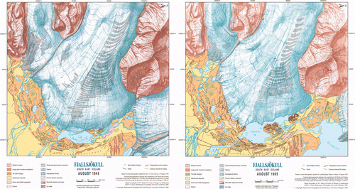
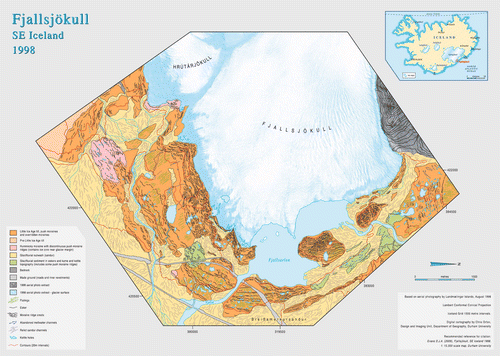
Figure A2. Map of Fjallsjökull and its foreland in 1998 mapped at 1:15,000 scale based upon uncorrected aerial photographs and using index contours from the earlier maps. Journal printed versions are thumbnail style prints of electronic version that will be made available for downloading from the Glasgow departmental website (http://www.ges.gla.ac.uk), which will be printed on A2 size paper to attain 1:15,000. A high quality version of this map is available online at: http:///www.informaworld.com/RSGJ
Mapping Fjallsjökull in 1965
The Iceland glacier mapping at Glasgow was inspired by the work Richard Finsterwalder who had the foresight to write in his classic paper from 1954 that ‘photogrammetric mapping is of fundamental value for certain types of glacier research, more particularly for the observation and estimation of the phenomena of glacier retreat’. At that time, most of the mapping of glaciers and their associated land forms was carried out by terrestrial (ground) photogrammetric methods using a photo-theodolite. This comprised a lightweight calibrated camera for the acquisition of the photographs and a theodolite to measure the network of control points needed to relate the photographs to the ground coordinate system. Specially built stereo-plotting instruments (Stereoautographs) were then used to construct the glacier maps from this material obtained in the field. Such methods were (and still are) applicable to those glaciers that occupy steep-sided alpine valleys, where the appropriate photographs could be taken from high viewpoints overlooking the glaciers. Indeed, using these methods, a large number of glacier surveys were undertaken in the Alps by glaciologists and surveyors from Germany, Austria and Switzerland, who then extended their mapping activities to the valley glaciers of the Himalayas, the Pamirs and the Andes.
However, these methods were not suitable for the mapping of ice caps, ice fields and glaciers of large lateral extent. Aerial photogrammetric methods were an appropriate solution, but, as Finsterwalder wrote, ‘Glacier survey from the air tends to be difficult. Since weather conditions in glacier regions are mostly bad, it is not easy to obtain the necessary ground control and to mark the points so that they can be reliably identified in the photographs … High precision cameras and stereo-plotting instruments are necessary to obtain the required accuracy.’ (Finsterwalder, Citation1954, p. 306)
Starting in 1960, a number of photogrammetrists in academic institutions became involved in glacier mapping based on the use of aerial photogrammetric methods. Many of them, such as Konecny, Dorrer, Faig (all based at the University of New Brunswick in Canada), Hothmer and Rudiger Finsterwalder (at the Technical University of Munich), were Finsterwalder's graduates. Another group, including Case and Forrest, emerged at Ohio State University, working under the guidance of Professor Brandenberger, a Swiss photogrammetrist, in co-operation with the Byrd Polar Research Center (BPRC) that had been founded at Ohio State in 1960. Glasgow University's Department of Geography, in which Gordon Petrie, John Keates and Barry Methley had all been involved professionally in surveying and mapping prior to joining the academic staff, formed part of this new development. Their first involvement was in August 1960 to assist a group from Cambridge University's Department of Geography which was undertaking surveys of the Gornergletscher in Switzerland. In 1961 and 1962, the Department then carried out mapping at Vindheimajökull (Iceland) and a glacier at Jotenheimen (Norway) on its own account. These initial efforts gave poor results due to the lack of suitable ground control points. This was caused partly through bad weather and partly by the inexperience of the physical geographers involved in the establishment of the ground control points. It was obvious too that using existing (mostly old) aerial photography taken with cameras with large geometric distortions and very poor illumination along the edges and in the corners of photographs was not suitable for the generation of the very accurate maps needed for mass balance and other studies and analyses being carried out for these glaciers.
The situation improved greatly when the next project involving the mapping of Casement Glacier, located at sea level in Alaska, was undertaken in the Department to underpin the work being carried out there by Rob Price, a glacial geomorphologist who had just joined the Department in 1963. Again difficulties were encountered with the lack of ground control points, but these were overcome through some technical tricks. A great step forward in this survey was the availability of new aerial photography covering the glacier together with a set of older photographs from 1948. The resulting maps were published and showed the enormous recession and down-wastage that had taken place during the 15 year period between the two sets of photographs (Petrie & Price, Citation1966; see above).
After a visit by Petrie and Price to inspect various Icelandic glaciers in June 1964, BreiÐamerkurjökull and Fjallsjökull were selected on the advice of Dr. Thorarinsson of the Icelandic Museum of Natural History. Thorarinsson knew from his own observations on the ground that a very rapid retreat of these glaciers had been taking place, leaving behind a large complex of moraines, eskers and other glacial depositional features. Since the snout of BreiÐamerkurjökull was 15 km wide, it presented a significant mapping challenge compared with narrow alpine valley glaciers. Consequently extensive preparations were made so that the mapping could be undertaken to the highest standards of accuracy and completeness. A field party spent 10 weeks in the area in the summer of 1965 undertaking a full ground control survey. Classical triangulation methods using theodolites were employed, since electronic distance measurement (EDM) instruments had only just been introduced and were unavailable in the Department at that time; GPS was the stuff of science fiction!
On completion of the extensive ground survey, the aerial photography was then acquired using the very latest Wild RC5a camera with its high quality, distortion-free lens which had been hired from Hunting Surveys. In this respect, the head of the company, Peter Mott, had been involved in glacier surveys in Greenland and the Karakorum before World War II and he also led the huge aerial survey project that undertook the mapping of Graham Land in the Antarctic Peninsula (Mott, Citation1986). So he was very interested in and very supportive of the Icelandic mapping project. The Wild camera was installed in an Icelandic coastguard aircraft and, in spite of very bad weather conditions, it was used to acquire panchromatic photography at 1:27,000 scale and colour and false colour photography at 1:16,000 scale in August 1965. Earlier aerial photography taken in 1945 by the US Air Force was also acquired through Landmælingar Islands, the Icelandic national mapping organization, which had also arranged the use of the coastguard aircraft.
On completion of the 1:15,000 scale base maps and the publication of the full colour 1:30,000 scale maps of BreiÐamerkurjökull for both 1945 and 1965, attention then turned to Fjallsjökull, although its eastern margin was included on the BreiÐamerkurjökull maps. The stereo-plotting of the glacier surface was undertaken by Roy Welch (later Professor at the University of Georgia) just prior to his return to the US in 1967, having completed his Ph.D. degree on BreiÐamerkurjökull. He paid special attention to the measurement of the crevasse patterns and the ogives (Forbes bands) that were such a prominent feature of the glacier surface of Fjallsjökull. The remainder of the stereo-plotting and the compilation of the maps at 1:15,000 scale for both 1945 and 1965 were carried out by Stephen Santa, then one of the Department's technical staff. The work was greatly facilitated by the Department's purchase of a Galileo Stereosimplex stereo-plotting instrument with its large Z (height) range that was especially suited to the mapping of high mountainous terrain.
The cartographic design of the final coloured maps at the scale of 1:30,000 for both BreiÐamerkurjökull and Fjallsjökull was carried out by John Keates, who also produced the beautiful hill shading drawings. The subsequent production of the final colour maps of Fjallsjökull using scribing, masking and photo-lettering techniques was carried out by Santa, Ian Connochie and Alan Kelly, who were members of the technical staff at that time, while the final photographic and colour proofing operations were carried by Ian Gerrard, who later became the Department's Chief Technician. The final maps for Fjallsjökull from 1945 and 1965 are presented here () as examples of the Department's glacier mapping activities. These maps have been reproduced in digital form from the original cartographic materials. As the original colour proofs were intended specifically to highlight the changes in glacier extent over time, the glacial geomorphology was highly generalized. Therefore, the glacial landforms on the 1945 and 1965 maps have been extracted from the new mapping based on the 1998 aerial photography.
Mapping Fjallsjökull in 1998
The 1998 map () was compiled directly from two non-rectified aerial photographs in order to avoid the lengthy photogrammetric procedure that is necessary to produce an orthophotograph. Because half of the snout and foreland area was already included on the 1998 BreiÐamerkurjökull map, the production of an orthophotograph and DEM for one extra aerial photograph was unnecessarily labour-intensive. Existing contours were used from the BreiÐamerkurjökull 1998 map for the eastern half and from the 1965 map for the western half of the Fjallsjökull foreland respectively. The latter was possible because the glacier margin occupied almost exactly the same position in 1998 and 1965; differences in the size of kettle holes between these two years are below the resolution of the contour interval. Distortion inherent in the use of non-rectified aerial photographs was kept to a minimum by the use of the central portions of the images for mapping. The glacier surface is represented by a mask compiled directly from the aerial photographs.
Unlike the 1945 and 1965 maps, which were compiled specifically to convey changes in glacier cover rather than landforms and sediments, the 1998 map depicts all aspects of the glacial geomorphology. Because the glacier snout had readvanced during the mid-1990s it stands at almost exactly the same position along most of its land-based margin in the 1998 and 1965 photographs. Consequently the landform and sediment mapping from the 1998 photography conveys much of the geomorphic detail that was evident on the earlier photographs, with the obvious exceptions of the localized impacts of developing kame and kettle topography and shifting outwash tracts.
The Fjallsjökull Glacial Landsystem
The eastern part of the Fjallsjökull foreland, because it was included in the BreiÐamerkurjökull maps, is integral to the active temperate glacial landsystem model presented by Evans and Twigg (Citation2002) and Evans (Citation2003). The glacial landforms all lie inside the ‘Little Ice Age’ limit, the abandonment of which has been traditionally dated to the end of the nineteenth or beginning of the twentieth centuries (Gordon & Sharp, Citation1982; Evans et al., Citation1999a) but could extend as far back in time as the late eighteenth century (Bradwell, Citation2004). Dominant landform elements in this landsystem include: (a) recessional push moraines, with their characteristic saw-tooth or crenulated plan forms (Supp. Figure S14); (b) overridden moraines, which are visible as fluted low amplitude arcuate ridges superimposed by recessional push moraines (Supp. Figure S15); (c) inset arcs of flutings whose crests lie at right angles to the push moraines at which they terminate; d) sandar, which occur either as proglacial outwash fans beyond the ‘Little Ice Age’ maximum limit or as moraine-parallel ribbon sandur; e) localized kame and kettle topography (). Additionally, there are rare pockets of hummocky moraine, which contain some discontinuous linear ridges (Supp. Figure S16), some eskers in the former suture zone between the two glaciers and an area of weakly fluted, low amplitude hummocky terrain with shallow kettle holes located at the northern end of the former suture zone (Supp. Figure S17).
Figure A3. Aerial photograph extracts (left = 1965; right = 1998) of kame and kettle topography on the southern part of the Fjallsjökull foreland, showing the localized nature of the predominantly large kettle holes and the occurrence of push moraine ridges on either side. These observations suggest that the holes represent the melt-out of snout ice buried by glacial outwash which has been bulldozed by active glacier recession. The trend and elevated positions of the abandoned proglacial outwash tracts clearly show that the glacier snout occupied the depressions during outwash progradation
Although localized, the development of the kame and kettle topography at Fjallsjökull clearly demonstrates that such landforms should not be used as indicators of glacier stagnation. This is illustrated by , which shows the localized nature and predominantly large size of the kettle holes and the occurrence of push moraine ridges on either side of the depressions. Also evident are the relatively elevated positions of the abandoned proglacial outwash tracts which bend around the southern margins of the depressions. These observations suggest that the holes represent the melt-out of snout ice buried by glacial outwash which has been contemporaneously bulldozed by active glacier recession.
Examination of aerial photographs shows that the hummocky moraine derives from the melt-out of the former medial moraine between Hrutajökull and Fjallsjökull and that the linear ridges become more fragmented over time (Supp. Figure S16). Additionally the linear ridges continue into push moraines on the adjacent fluted till surfaces, indicating that they too originated as push moraines but, because most of their debris was supplied supraglacially, contained ice cores and therefore have been fragmented by differential melting. Unlike BreiÐamerkurjökull, where the medial moraines are represented only by linear boulder spreads, the former medial moraines of Fjallsjökull/Hrutajökull contain more debris and therefore have retained the linearity produced by ice-marginal pushing. This constitutes a suitable analogue for many linear hummocky moraine spreads in the Loch Lomond Readvance landforms of the Scottish Highlands (Benn, Citation1992).
The area of fluted hummocks (Supp. Figure S17) at the northeastern corner of the snout can only be interpreted as a glacially overridden spread of kame and kettle topography. The materials are gravelly and no medial moraine is visible on the 1945 aerial photographs or depicted on earlier maps. Moreover, the area is part of a corridor of glacifluvial sediments and esker ridges, indicating that englacial and subglacial drainage concentrated on the suture zone between the two glaciers during recent ice recession (Evans & Twigg, Citation2002), and therefore it is most likely that such a drainage pattern would have existed during earlier periods of ice recession. A valley also lies directly upslope on the margins of the mountain Rakartindur, a likely location for ice-marginal lake damming and therefore a potential source of meltwater; the ice-dammed lake on the east face of Rakartindur that catastrophically drained to produce the pitted sandur reported by Price (Citation1971) would also drain towards this suture zone during periods of more extensive ice. Because flutings run across the water-filled pits it is likely that the hummocky terrain still contains glacier ice and that till was streamlined before substantial pitting had taken place.
Together with the fluted arcuate ridges, interpreted as overridden push moraines, the fluted hummocks demonstrate that glacial landforms can survive overriding. This is a modern analogue for some ancient hummocky terrain, where in situ interglacial organic deposits lying beneath the most recent till carapace demonstrate that it represents a glacially overridden supraglacial landform assemblage (e.g. Lagerback, Citation1988). Similar stratigraphic evidence has been uncovered at Fjallsjökull by Rose et al. (Citation1997). They report a sequence of non-glacial sediments and peat, deposited during the mid-Holocene and then glacitectonized during the Little Ice Age advance. The architecture of the sediments and peat reveal that a substantial moraine ridge existed in the area prior to the most recent Little Ice Age advance. This buried moraine forms the southern boundary of the overdeepening in which Fjallsarlon has developed over time (Supp. Figure S18).
Conclusions
Temporal controls on process-form relationships in glacial geomorphology have always been problematic, due to the accessibility of glacier beds and the long periods of time over which landforms evolve. Repeat aerial photography and accurate photogrammetric survey clearly alleviates much of this, but very few glacier snouts have been subject to such repeated survey. The large body of knowledge on active, temperate glacier snouts and their geomorphic signatures is due in no small measure to the mapping of the Icelandic glacier forelands (Price, Citation1969; Evans, Citation2003a). Fjallsjökull is an important glacier in this respect in that it underwent a significant readvance in the mid-1990s, constructing a complex sequence of push moraines that have facilitated the in-depth study of moraine and subglacial till genesis (cf. Price, Citation1970; Evans & Hiemstra, Citation2005). The maps presented here for 1945, 1965 and 1998 capture that glacier snout activity and allow us to assess the observations on moraine formation in the context of a whole landsystem. Significant also is the development of kame and kettle topography in association with active recession, warning against the use of such landforms as indicators of glacier stagnation. Additionally, the evolution and preservation potential of linear hummocky moraine, a contentious issue in modern glacial research (see Evans, 2009, for a review), is documented in time slices on the aerial photography. Finally, overridden moraines, manifest in fluted hummocky terrain, low amplitude arcuate ridges and the large moraine complex that forms the southern boundary of the Fjallsjökull overdeepening, are common features in Icelandic glacier forelands and their presence demonstrates that significant elements of our glacial landform legacy are palimpsests of older events.
Note
1Figures labelled ‘supp. Figure Sx’ have not been published in this article but are available online as supplementary material at http:///www.informaworld.com/RSGJ.
rsgj_a_436609_sup_12303143.pdf
Download PDF (7.7 MB)rsgj_a_436609_sup_12303494.pdf
Download PDF (1.7 MB)rsgj_a_436609_sup_12303113.pdf
Download PDF (2.4 MB)rsgj_a_436609_sup_12303139.pdf
Download PDF (214.5 KB)rsgj_a_436609_sup_12303125.pdf
Download PDF (6.3 MB)Acknowledgements
Thanks to all who have provided information for this paper and to Chris Philo for giving DJAE the opportunity to write it for SGJ. As it is a personal view of glacial geomorphology at Glasgow I (DJAE), apologise for any inaccuracies or mis-representations that may have crept in despite my best efforts to trawl the archives and seek input from those involved. Thanks to Rob Price for providing some wonderful photographs from the BreiÐa project. Gordon Petrie and Rob Price provided a wealth of fascinating detail on the logistics and science behind the glacier research at Glasgow, and I am sorry that space restrictions prevent me from including everything, much as I would have liked to. First-class technical assistance has been provided at Glasgow over the years, but special mention should be made of Ian Gerrard, Yvonne Finlayson and Les Hill. The cartography for the 1998 Fjallsjökull map was undertaken by Chris Orton in Geography at the University of Durham. Financial assistance was repeatedly provided by the Carnegie Trust, the Royal Scottish Geographical Society and the University of Glasgow Court via the Exploration Society. Thanks to Simon Carr and Richard Waller who, as referees, provided encouraging and sage comments. Best wishes to all who have participated in glacial research at Glasgow, from undergraduate to staff too numerous to mention, and thanks for the memories as well as the science. My expedition members still use the 1994 whiskey tumblers!
Related Research Data
References1) Involving Glasgow-based researchers
- Bates , P. , Siegert , M. , Lee , V. , Hubbard , B. and Nienow , P. W. 2003 . Numerical simulation of three dimensional velocity fields in pressurised and non-pressurised Nye channels . Annals of Glaciology , 37 : 281 – 285 .
- Benn , D. I. and Evans , D. J. A. 1993 . Glacimarine deltaic deposition and proglacial tectonics: the Loch Don Sand Moraine, Isle of Mull . Journal of Quaternary Science , 8 : 279 – 291 .
- Benn , D. I. and Evans , D. J. A. 1996 . The interpretation and classification of subglacially deformed materials . Quaternary Science Reviews , 15 : 23 – 52 .
- Benn , D. I. and Evans , D. J. A. 1998 . Glaciers and Glaciation , London : Arnold .
- Bentley , M. J. , Evans , D. J. A. , Fogwill , C. J. , Hansom , J. D. , Sugden , D. E. and Kubik , P. W. 2007 . Glacial geomorphology and chronology of deglaciation, South Georgia, sub-Antarctic . Quaternary Science Reviews , 26 : 644 – 677 .
- Bingham , R. 2003 . Hydrology and Dynamics of a High Arctic Polythermal Glacier , University of Glasgow . Unpublished PhD Thesis
- Bingham , R. , Hubbard , A. , Nienow , P. and Sharp , M. 2008 . An investigation into the mechanisms controlling seasonal speed-up events at a High Arctic glacier . Journal of Geophysical Research, Earth Surface , 113 : F02006 doi: 10.1029/2007JF000832
- Bingham , R. , Nienow , P. W. and Sharp , M. 2003 . Intra-annual and intra-seasonal flow dynamics of a High Arctic polythermal valley glacier . Annals of Glaciology , 37 : 181 – 188 .
- Bingham , R. , Nienow , P. W. , Sharp , M. and Boon , S. 2005 . Subglacial drainage processes at a High Arctic polythermal valley glacier . Journal of Glaciology , 51 : 15 – 24 .
- Bingham , R. , Nienow , P. , Sharp , M. and Boon , S. 2006 . Propagation of high-velocity events in the ablation zone of a High Arctic polythermal glacier: relation to seasonal changes in subglacial drainage system structure . Earth Surface Processes and Landforms , : 1463 – 1479 .
- Boon , S. , Sharp , M. and Nienow , P. W. 2003 . Impact of an extreme melt event on the runoff and hydrology of a high Arctic glacier . Hydrological Processes , 17 : 1051 – 1072 .
- Bradwell , T. , Fabel , D. , Stoker , M. , Mathers , H. , McHargue , L. and Howe , J. 2008 . Ice caps existed throughout the Lateglacial Interstadial in northern Scotland . Journal of Quaternary Science , 23 : 401 – 407 .
- Campbell , F. 2006 . The Impact of Snowpack Hydrology on Ice Dynamics , University of Glasgow . Unpublished PhD Thesis
- Campbell , F. , Nienow , P. and Purves , R. 2006 . Role of the supraglacial snowpack in mediating meltwater delivery to the glacier system as inferred from dye tracer investigations . Hydrological Processes , 20 : 969 – 985 .
- Clark , C. D. , Evans , D. J. A. , Khatwa , A. , Bradwell , T. , Jordan , C. J. , Marsh , S. H. , Mitchell , W. A. and Bateman , M. D. 2004 . Map and GIS database of glacial landforms and features related to the last British Ice Sheet . Boreas , 33 : 359 – 375 .
- Copland , L. , Sharp , M. and Nienow , P. W. 2003b . Links between short-term velocity variations and the subglacial hydrology of a polythermal glacier . Journal of Glaciology , 49 : 337 – 348 .
- Copland , L. , Sharp , M. , Nienow , P. W. and Bingham , R. 2003a . The distribution of basal motion beneath a High Arctic polythermal glacier . Journal of Glaciology , 49 : 407 – 414 .
- Dyke , A. S. and Evans , D. J. A. 2003 . “ Ice-marginal terrestrial landsystems: northern Laurentide and Innuitian ice sheet margins ” . In Glacial Landsystems , Edited by: Evans , D. J. A. 143 – 165 . London : Arnold .
- England , J. , Atkinson , N. , Dyke , A. S. , Evans , D. J. A. and Zreda , M. 2004 . Late Wisconsinan buildup and wastage of the Innuitian Ice Sheet across southern Ellesmere Island, Nunavut . Canadian Journal of Earth Sciences , 41 : 39 – 61 .
- England , J. , Smith , I. R. and Evans , D. J. A. 2000 . The last glaciation of east-central Ellesmere Island, Nunavut: ice dynamics, deglacial chronology and sea level change . Canadian Journal of Earth Sciences , 37 : 1355 – 1371 .
- Evans , D. J. A. 1989 . Apron entrainment at the margins of sub-polar glaciers, NW Ellesmere Island, Canadian high arctic . Journal of Glaciology , 35 : 317 – 324 .
- Evans , D. J. A. 1990a . The effect of glacier morphology on surficial geology and glacial stratigraphy in a high arctic mountainous terrain . Zeitschrift fur Geomorphologie , : 48 – 503 .
- Evans , D. J. A. 1990b . The last glaciation and relative sea level history of NW Ellesmere Island, Canadian high arctic . Journal of Quaternary Science , 5 : 67 – 82 .
- Evans , D. J. A. 1996 . A possible origin for a mega-fluting complex on the southern Alberta prairies, Canada . Zeitschrift fur Geomorphologie , : 125 – 148 . Supp.Bd.106
- Evans , D. J. A. 1999 . Glacial debris transport and moraine deposition: a case study of the Jardalen cirque complex, Sogn-og-Fjordane, western Norway . Zeitschrift fur Geomorphologie , 43 : 203 – 234 .
- Evans , D. J. A. 2000a . Quaternary geology and geomorphology of the Dinosaur Provincial Park area and surrounding plains, Alberta, Canada: the identification of former glacial lobes, drainage diversions and meltwater flood tracks . Quaternary Science Reviews , 19 : 931 – 958 .
- Evans , D. J. A. 2000b . A gravel outwash/deformation till continuum, Skalafellsjökull, Iceland . Geografiska Annaler , 82A : 499 – 512 .
- Evans D. J. A. 2003a Glacial Landsystems London Arnold
- Evans D. J. A. 2003b The Quaternary of the Western Highland Boundary – Field Guide London Quaternary Research Association
- Evans D. J. A. 2004 Geomorphology: Critical Concepts in Geography. Volume IV: Glacial Geomorphology London Routledge
- Evans , D. J. A. 2008 . “ Glacial depositional processes and forms ” . In The History of the Study of Landforms: Volume 4 – Quaternary and Recent Processes and Forms (1890–1965) and the Mid-Century Revolutions , Edited by: Burt , T. P. , Chorley , R. J. , Brunsden , D. , Cox , N. J. and Goudie , A. S. 495 – 619 . London : Geological Society .
- Evans D. J. A. Benn D. I. 2004 A Practical Guide to the Study of Glacial Sediments London Arnold
- Evans , D. J. A. and Campbell , I. A. 1995 . Quaternary stratigraphy of the buried valleys of the lower Red Deer River, Alberta, Canada . Journal of Quaternary Science , 10 : 123 – 148 .
- Evans , D. J. A. and Hiemstra , J. F. 2005 . Till deposition by glacier submarginal, incremental thickening . Earth Surface Processes and Landforms , 30 : 1633 – 1662 .
- Evans , D. J. A. and Ó Cofaigh , C. 2003 . Depositional evidence for marginal oscillations of the Irish Sea ice stream in southeast Ireland during the last glaciations . Boreas , 32 : 76 – 101 .
- Evans , D. J. A. and Rea , B. R. 1999 . Geomorphology and sedimentology of surging glaciers: a land-systems approach . Annals of Glaciology , 28 : 75 – 82 .
- Evans , D. J. A. and Rea , B. R. 2003 . “ Surging glacier landsystem ” . In Glacial Landsystems , Edited by: Evans D. J. A. , D. J. A. 259 – 288 . London : Arnold .
- Evans , D. J. A. and Rea , B. R. 2005 . Late Weichselian deglaciation and sea level history of St. Jonsfjorden, Spitsbergen: a contribution to ice sheet reconstruction . Scottish Geographical Journal , 121 : 175 – 202 .
- Evans , D. J. A. and Rose , J. 2003 . Classic Landforms of the Loch Lomond Area , Sheffield : Geographical Association .
- Evans , D. J. A. and Russell , A. J. 2002 . Modern and ancient ice-marginal landsystems . Sedimentary Geology , 149 : 1 – 3 .
- Evans , D. J. A. and Twigg , D. R. 2000 . BreiÐamerkurjökull 1998 , University of Glasgow and Loughborough University . 1:30,000 Scale Map
- Evans , D. J. A. and Twigg , D. R. 2002 . The active temperate glacial landsystem: a model based on BreiÐamerkurjökull and Fjallsjökull, Iceland . Quaternary Science Reviews , 21 : 2143 – 2177 .
- Evans , D. J. A. and Twigg , D. R. 2004 . Þorisjökull: Surficial Geology and Geomorphology of a Plateau Icefield , University of Glasgow and Loughborough University . 1:25,000 scale map poster
- Evans , D. J. A. and Wilson , S. B. 2006a . A temporary exposure through the Loch Lomond Readvance end moraine/ice-contact delta complex near Drymen, Stirlingshire . Scottish Geographical Journal , 122 : 344 – 351 .
- Evans , D. J. A. and Wilson , S. B. 2006b . Scottish Landform Example 39: The Lake of Menteith glacitectonic hill-hole pair . Scottish Geographical Journal , 122 : 352 – 364 .
- Evans , D. J. A. , Archer , S. and Wilson , D. J. H. 1999a . A comparison of the lichenometric and Schmidt hammer dating techniques based on data from the proglacial areas of some Icelandic glaciers . Quaternary Science Reviews , 18 : 13 – 41 .
- Evans , D. J. A. , Butcher , C. and Kirthisingha , A. V. 1994 . Neoglaciation and an early Little Ice Age in western Norway: evidence from the Sandane area . The Holocene , 4 : 278 – 289 .
- Evans , D. J. A. , Clark , C. D. and Mitchell , W. A. 2005 . The last British Ice Sheet: a review of the evidence utilized in the compilation of the Glacial Map of Britain . Earth Science Reviews , 70 : 253 – 312 .
- Evans , D. J. A. , Lemmen , D. S. and Rea , B. R. 1999c . Glacial landsystems of the southwest Laurentide Ice Sheet: modern Icelandic analogues . Journal of Quaternary Science , 14 : 673 – 691 .
- Evans , D. J. A. , Owen , L. A. and Roberts , D. H. 1995 . Stratigraphy and sedimentology of Devensian (Dimlington Stadial) deposits, East Yorkshire, England . Journal of Quaternary Science , 10 : 241 – 265 .
- Evans , D. J. A. , Phillips , E. R. , Hiemstra , J. F. and Auton , C. A. 2006d . Subglacial till: formation, sedimentary characteristics and classification . Earth Science Reviews , 78 : 115 – 176 .
- Evans , D. J. A. , Rea , B. R. and Benn , D. I. 1998 . Subglacial deformation and bedrock plucking in areas of hard bedrock . Glacial Geology and Geomorphology , rp04/1998. Available at: http://ggg.qub.ac.uk/ggg/papers/full/1998/rp041998/rp04.html
- Evans , D. J. A. , Rea , B. R. , Hansom , J. D. and Whalley , W. B. 2002 . Geomorphology and style of plateau icefield deglaciation in fjord terrains: the example of Troms-Finnmark, north Norway . Journal of Quaternary Science , 17 : 221 – 239 .
- Evans , D. J. A. , Salt , K. E. and Allen , C. S. 1999b . Glacitectonized lake sediments, Barrier Lake, Kananaskis Country, Canadian Rocky Mountains . Canadian Journal of Earth Sciences , 36 : 395 – 407 .
- Evans , D. J. A. , Thomson , S. A. and Clark , C. D. 2001 . “ The glacial history of East Yorkshire ” . In The Quaternary of East Yorkshire and North Lincolnshire, Field Guide , Edited by: Bateman , M. D. , Buckland , P. C. , Frederick , C. D. and Whitehouse , N. J. 1 – 12 . London : Quaternary Research Association .
- Evans , D. J. A. , Twigg , D. R. and Rea , B. R. 2006b . Surging glacier landsystem of Tungnaárjökull, Iceland , Durham University . 1:25,000 scale map poster
- Evans , D. J. A. , Twigg , D. R. and Shand , M. 2006 . Surficial geology and geomorphology of the Þorisjökull plateau icefield, west-central Iceland . Journal of Maps , : 17 – 29 .
- Evans , D. J. A. , Twigg , D. R. , Rea , B. R. and Shand , M. 2007 . Surficial geology and geomorphology of the Brúarjökull surging glacier landsystem . Journal of Maps , : 349 – 367 .
- Evans , D. J. A. , Twigg , D. R. , Rea , B. R. and Shand , M. 2007b . Bruarjökull: surficial geology and geomorphology of the surging glacier landsystem , Universities of Glasgow, Durham, Loughborough and Aberdeen . 1:30,000 scale map poster
- Evans , D. J. A. , Wilson , S. B. and McGregor , D. F. M. 2006c . Scottish Landform Example 37: ‘The Kaims’ of Bedshiel . Scottish Geographical Journal , 122 : 76 – 83 .
- Fabel , D. , Fink , D. , Fredin , O. , Harbor , J. , Land , M. and Stroeven , A. P. 2006 . Cosmogenic exposure ages from relict lateral moraines overridden by the Fennoscandian ice sheet in northern Sweden . Quaternary Research , 65 : 136 – 146 .
- Fink , D. , McKelvey , B. , Hambrey , M. J. , Fabel , D. and Brown , R. 2006 . Pleistocene deglaciation chronology of the Amery Oasis and Radok Lake, northern Prince Charles Mountains, Antarctica . Earth and Planetary Science Letters , 243 : 229 – 243 .
- Garwood , E. J. and Gregory , J. W. 1898 . Contributions to the glacial geology of Spitsbergen . Quarterly Journal of the Geological Society, London , 54 : 197 – 227 .
- Gemmell , A. M. D. 1971 . The Glaciation of the Island of Arran , University of Glasgow . Unpublished PhD thesis…
- Golledge , N. R. , Fabel , D. , Everest , J. D. , Freeman , S. and Binnie , S. 2007 . First cosmogenic 10 Be age constraint of the timing of Younger Dryas glaciation and ice cap thickness, western Scottish Highlands . Journal of Quaternary Science , 22 : 785 – 791 .
- Goodsell , B. , Hambrey , M. J. , Glasser , N. F. , Nienow , P. W. and Mair , D. 2005 . The structural glaciology of a temperate valley glacier: Haut Glacier d'Arolla, Valais, Switzerland . Arctic, Alpine and Antarctic Research , 37 : 218 – 232 .
- Gregory , J. W. 1907 . A glaciated rock surface at Lugton, North Ayrshire . Transactions of the Geological Society of Glasgow , 13 : 10 – 18 .
- Gregory , J. W. 1911–1912 . The Polmont kame and on the classification of Scottish Kames . Transactions of the Geological Society of Glasgow , 14 : 199 – 218 .
- Gregory , J. W. 1912a . The relations of eskers and kames . Geographical Journal , 40 : 169 – 75 .
- Gregory , J. W. 1912b . Fiords in relation to earth movements . Nature , 89 : 179 – 183 .
- Gregory , J. W. 1913a . The Polmont kame and on the classification of Scottish Kames . Transactions of the Geological Society of Glasgow , 14 : 199 – 218 .
- Gregory , J. W. 1913b . The Nature and Origin of Fiords , London : John Murray .
- Gregory , J. W. 1914 . Corries, with special reference to those of the Campsie Fells . Transactions of the Geological Society of Glasgow , 15 : 84 – 98 .
- Gregory , J. W. 1915a . The kames of Carstairs . Scottish Geographical Magazine , 31 : 465 – 76 .
- Gregory , J. W. 1915b . The geology of the Glasgow district. XI. The kames of Carstairs . Proceedings of the Geologists Association , 26 : 187 – 88 .
- Gregory , J. W. 1922 . The English ‘Eskers’– their structure and distribution . Geological Magazine , 59 : 25 – 44 .
- Gregory , J. W. 1926a . The Scottish kames and their evidence on the glaciation of Scotland . Transcations of the Royal Society of Edinburgh , 54 : 395 – 432 .
- Gregory , J. W. 1926b . Scottish drumlins . Transactions of the Royal Society of Edinburgh , 54 : 433 – 40 .
- Gregory , J. W. 1928 . The geology of Loch Lomond . Transactions of the Geological Society of Glasgow , 18 : 301 – 23 .
- Harbor , J. , Stroeven , A. P. , Fabel , D. , Clarhäll , A. , Kleman , J. , Li , Y. , Elmore , D. and Fink , D. 2006 . Cosmogenic nuclide evidence for minimal erosion across two subglacial sliding boundaries of the late glacial Fennoscandian Ice sheet . Geomorphology , 75 : 90 – 99 .
- Hiemstra , J. F. , Evans , D. J. A. , Scourse , J. D. , McCarroll , D. , Furze , M. F. A. and Rhodes , E. 2006 . New evidence for a grounded Irish Sea glaciation of the Isles of Scilly, UK . Quaternary Science Reviews , 25 : 299 – 309 .
- Hiemstra , J. F. , Rijsdijk , K. F. , Evans , D. J. A. and van der Meer , J. J. M. 2005 . Integrated micro- and macro-scale sediment analyses of Last Glacial Maximum Irish Sea diamicts from Abermawr and Traeth-y-Mwnt, Wales, UK . Journal of Quaternary Science , 34 : 61 – 74 .
- Holden , W. G. 1977 . The glaciation of central Ayrshire , University of Glasgow . Unpublished PhD thesis…
- Howarth , P. J. 1968 . Geomorphological and Glaciological Studies, Eastern BreiÐamerkurjökull, Iceland , University of Glasgow . Unpublished Ph.D. Thesis…
- Howarth , P. J. 1971 . Investigations of two eskers at eastern BreiÐamerkurjökull, Iceland . Arctic and Alpine Research , 3 : 305 – 318 .
- Howarth , P. J. and Price , R. J. 1969 . The proglacial lakes of BreiÐamerkurjökull and Fjallsjökull, Iceland . Geographical Journal , 35 : 573 – 581 .
- Howarth , P. J. and Welch , R. 1969a . BreiÐamerkurjökull, South-east Iceland, August 1945 , University of Glasgow . 1:30,000 scale map
- Howarth , P. J. and Welch , R. 1969b . BreiÐamerkurjökull, South-east Iceland, August 1965 , University of Glasgow . 1:30,000 scale map
- Hubbard , B. , Hubbard , A. , Mader , H. , Tison , J-L. , Grust , K. and Nienow , P. W. 2003 . Spatial variability in the water content and rheology of temperate glaciers: Glacier de Tsanfleuron, Switzerland . Annals of Glaciology , 37 : 1 – 6 .
- Jardine , W. G. 1980 . Glasgow Region Field Guide , Glasgow : Quaternary Research Association .
- Leading Edge (University of Glasgow) . 2001 . Glacier maps chart climate change . Leading Edge, University of Glasgow , 7 : 2 – 3 .
- Li , Y. , Fabel , D. , Stroeven , A. P. and Harbor , J. 2008 . Unraveling complex exposure-burial histories of bedrock surfaces under ice sheets by integrating cosmogenic nuclide concentrations with climate proxy records . Geomorphology , 99 : 139 – 149 .
- Mair , D. , Nienow , P. W. , Sharp , M. , Wohlleben , T. and Willis , I. 2002 . Influence of subglacial drainage system evolution on glacier surface motion: Haut Glacier d'Arolla, Switzerland . Journal of Geophysical Research , 107 ( B8 ) doi:10.1029/2001JB000514
- Mair , D. , Nienow , P. W. , Willis , I. and Sharp , M. 2001 . Spatial patterns of glacier dynamics during a high velocity event: Haut Glacier d'Arolla, Switzerland . Journal of Glaciology , 47 : 9 – 20 .
- Mair , D. , Willis , I. , Hubbard , B. , Fischer , U. F. , Nienow , P. W. and Hubbard , A. 2003 . Hydrological controls on patterns of surface, internal and basal motion during three ‘spring events’: Haut Glacier d'Arolla, Switzerland . Journal of Glaciology , 49 : 555 – 567 .
- May , J. A. 1981 . The Glaciation and Deglaciation of Upper Nithsdale and Annandale , University of Glasgow . Unpublished PhD thesis…
- McDougall , D. A. 1998 . Loch Lomond Stadial Plateau Icefields in the Lake District, Northwest England , University of Glasgow . Unpublished PhD thesis
- McDougall , D. A. 2001 . The geomorphological impact of Loch Lomond (Younger Dryas) Stadial plateau icefields in the central Lake District, northwest England . Journal of Quaternary Science , 16 : 531 – 543 .
- McLellan , A. G. 1969 . The last glaciation and deglaciation of central Lanarkshire . Scottish Journal of Geology , 5 : 248 – 268 .
- Nienow , P. W. , Hubbard , A. , Hubbard , B. , Chandler , D. , Mair , D. , Sharp , M. and Willis , I. 2005 . Hydrological controls on diurnal ice flow variability in valley glaciers . Journal of Geophysical Research , 110 : F04002 doi: 10.1029/2003 JF000112
- Nienow , P. , Sharp , M. and Willis , I. 1998 . Seasonal changes in the morphology of the subglacial drainage system, Haut Glacier d'Arolla, Switzerland . Earth Surface Processes and Landforms , 23 : 825 – 843 .
- Ó Cofaigh , C. , Dowdeswell , J. A. , Allen , C. S. , Hiemstra , J. F. , Pudsey , C. J. , Evans , J. and Evans , D. J. A. 2005 . Flow dynamics and till genesis associated with a marine-based Antarctic palaeo-ice stream . Quaternary Science Reviews , 24 : 709 – 740 .
- Ó Cofaigh , C. and Evans , D. J. A. 2001a . Deforming bed conditions associated with a major ice stream of the last British ice sheet . Geology , 29 : 795 – 798 .
- Ó Cofaigh , C. and Evans , D. J. A. 2001b . Sedimentary evidence for deforming bed conditions associated with a grounded Irish Sea glacier, southern Ireland . Journal of Quaternary Science , 16 : 435 – 454 .
- Ó Cofaigh , C. , Evans , D. J. A. and England , J. 2003 . “ Ice-marginal terrestrial landsystems: sub-polar glacier margins of the Canadian and Greenland high arctic ” . In Glacial Landsystems , Edited by: Evans , D. J. A. 44 – 64 . London : Arnold .
- Ó Cofaigh , C. , Lemmen , D. S. , Evans , D. J. A. and Bednarski , J. 1999 . Glacial landform-sediment assemblages in the Canadian high arctic and their implications for late Quaternary glaciations . Annals of Glaciology , 28 : 195 – 201 .
- Petrie , G. and Price , R. J. 1966 . Photogrammetric measurements of the ice wastage and morphological changes near the Casement Glacier, Alaska . Canadian Journal of Earth Sciences , 3 : 827 – 840 .
- Phillips , E. R. , Evans , D. J. A. and Auton , C. A . 2002 . Polyphase deformation at an oscillating ice margin following the Loch Lomond Readvance, central Scotland, UK . Sedimentary Geology , 149 : 157 – 182 .
- Price , R. J. 1960 . Glacial meltwater channels in the upper Tweed drainage basin . Geographical Journal , 126 : 485 – 489 .
- Price , R. J. 1961 . The Deglaciation of the Upper Tweed Basin , University of Edinburgh . Unpublished PhD thesis
- Price , R. J. 1963 . A glacial meltwater drainage system in Peebleshire, Scotland . Scottish Geographical Magazine , 79 : 133 – 141 .
- Price , R. J. 1964 . Landforms Produced by the Wastage of the Casement Glacier, Southeast Alaska , Ohio State University . Institute of Polar Studies, Report 9
- Price , R. J. 1965 . The changing proglacial environment of the Casement Glacier, Glacier Bay, Alaska . Transactions of the Institute of British Geographers , 36 : 107 – 16 .
- Price , R. J. 1966 . Eskers near the Casement Glacier, Alaska . Geografiska Annaler , 48 : 111 – 125 .
- Price , R. J. 1968 . The University of Glasgow BreiÐamerkurjökull Project (1964–67) . Jökull , 18 : 389 – 394 .
- Price , R. J. 1969 . Moraines, sandar, kames and eskers near BreiÐamerkurjökull, Iceland . Transactions of the Institute of British Geographers , 46 : 17 – 43 .
- Price , R. J. 1970 . Moraines at Fjallsjökull, Iceland . Arctic and Alpine Research , 2 : 27 – 42 .
- Price , R. J. 1971 . The development and destruction of a sandur, BreiÐamerkurjökull, Iceland . Arctic and Alpine Research , 3 : 225 – 237 .
- Price , R. J. 1973 . Glacial and Fluvioglacial Landforms , London : Longman .
- Price , R. J. 1980 . “ Rates of geomorphological changes in proglacial areas ” . In Timescales in Geomorphology , Edited by: Cullingford , R. A. , Davidson , D. A. and Lewin , J. 79 – 93 . Chichester : Wiley .
- Price , R. J. 1982 . Changes in the proglacial area of BreiÐamerkurjökull, southeastern Iceland: 1890–1980 . Jökull , 32 : 29 – 35 .
- Price , R. J. 1983 . Scotland's Environment During the Last 30,000 Years , Edinburgh : Scottish Academic Press .
- Price , R. J. and Howarth , P. J. 1968 . Glacial environments in south-east Iceland (with particular reference to BreiÐamerkurjökull) – A Field Guide , Glasgow : Quaternary Field Study Group .
- Price , R. J. and Howarth , P. J. 1970 . The evolution of the drainage system (1904–1965) in front of BreiÐamerkurjökull, Iceland . Jökull , 20 : 27 – 37 .
- Rea , B. R. and Evans , D. J. A. 2003 . “ Plateau icefield landsystems ” . In Glacial Landsystems , Edited by: Evans , D. J. A. 407 – 431 . London : Arnold .
- Rea , B. R. , Whalley , W. B. , Evans , D. J. A. , Gordon , J. E. and McDougall , D. A. 1998 . Plateau icefields: geomorphology and dynamics . Quaternary Proceedings , 6 : 35 – 54 .
- Renwick , J. and Gregory , J. W. 1909 . The Loch Lomond moraines . Transactions of the Geological Society of Glasgow , 13 : 45 – 55 .
- Rose , J. 1981 . Field guide to the Quaternary geology of the southern part of the Loch Lomond basin . Proceedings of the Geological Society of Glasgow , 122/123 : 12 – 28 .
- Rose , J. 1987 . “ Drumlins as part of a glacier bedform continuum ” . In Drumlin Symposium , Edited by: Menzies , J. and Rose , J. 103 – 116 . Rotterdam : Balkema .
- Rose , J. 1989a . “ Stadial type sections in the British Quaternary ” . In Quaternary Type Sections: Imagination or Reality? , Edited by: Rose , J. and Schlüchter , C. 45 – 67 . Rotterdam : Balkema .
- Rose , J. 1989b . Glacier stress patterns and sediment transfer associated with the formation of superimposed flutes . Sedimentary Geology , 62 : 151 – 176 .
- Rose , J. and Letzer , J. M. 1975 . Drumlin measurements: a test of the reliability of data derived from 1:25,000 scale topographic maps . Geological Magazine , 112 : 361 – 371 .
- Rose , J. and Letzer , J. M. 1977 . Superimposed drumlins . Journal of Glaciology , 18 : 471 – 480 .
- Rose , J. and Smith , M. J. 2008 . Glacial geomorphological maps of the Glasgow region, western central Scotland . Journal of Maps , : 399 – 416 .
- Rose , J. , Lowe , J. J. and Switsur , R. 1988 . A radiocarbon date on plant detritus beneath till from the type area of the Loch Lomond Readvance . Scottish Journal of Geology , 24 : 113 – 124 .
- Salt , K. E. 2001 . Palaeo ice sheet dynamics and depositional settings of the Late Devensian Ice sheet in South West Scotland , University of Glasgow . Unpublished Ph.D. thesis…
- Salt , K. E. and Evans , D. J. A. 2004 . Scottish Landform Example 32: Superimposed subglacially streamlined landforms of southwest Scotland . Scottish Geographical Journal , 120 : 133 – 147 .
- Sharp , M. , Skidmore , M. and Nienow , P. W. 2002 . The chemistry of a high Arctic supraglacial snow cover . Journal of Glaciology , 48 : 149 – 158 .
- Soons , J. M. 1958a . The geomorphology of the Ochil Hills , University of Glasgow . Unpublished PhD thesis
- Soons , J. M. 1958b . Landscape evolution in the Ochil Hills . Scottish Geographical Magazine , 74 : 86 – 97 .
- Soons , J. M. 1960 . Glacial retreat stages in Kinross-shire . Scottish Geographical Magazine , 76 : 46 – 57 .
- Spedding , N. and Evans , D. J. A. 2002 . Sediments and landforms at Kvíárjökull, south-east Iceland: a reappraisal of the glaciated valley landsystem . Sedimentary Geology , 149 : 21 – 42 .
- Stroeven , A. P. , Harbor , J. , Fabel , D. , Kleman , J. , Hättestrand , C. , Elmore , D. and Fink , D. 2006 . “ Characteristic cosmogenic nuclide concentrations in relict surfaces of formerly glaciated regions ” . In Glacier science and environmental change , Edited by: Knight , P. G. 447 – 449 . Oxford : Blackwell .
- Swift , D. A. 2002 . The provenance of suspended sediment from subglacial drainage systems , University of Glasgow . Unpublished PhD Thesis
- Swift , D. A. , Evans , D. J. A. and Fallick , A. E. 2006 . Transverse englacial debris-rich ice bands at Kvíárjökull, southeast Iceland . Quaternary Science Reviews , 25 : 1708 – 1718 .
- Swift , D. A. , Nienow , P. W. and Hoey , T. B. 2005a . Basal sediment evacuation by subglacial meltwater: suspended sediment transport from Haut Glacier d'Arolla, Switzerland . Earth Surface Processes and Landforms , 30 : 867 – 883 .
- Swift , D. A. , Nienow , P. W. , Hoey , T. B. and Mair , D. W. F. 2005b . Seasonal evolution of runoff from Haut Glacier d'Arolla, Switzerland and implications for glacial geomorphic processes . Journal of Hydrology , 309 : 133 – 148 .
- Swift , D. A. , Nienow , P. W. , Spedding , N. and Hoey , T. 2002 . Geomorphic implications of subglacial drainage configuration: rates of suspended sediment evacuation controlled by seasonal drainage system evolution . Sedimentary Geology , 149 : 5 – 19 .
- Thomson , S. A. 2003 . Reconstruction of the Dimlington Stadial glaciation of Holderness, East Yorkshire, England , University of Glasgow . Unpublished PhD Thesis
- Thomson , S. A. and Evans , D. J. A. 2001 . “ Gembling ” . In The Quaternary of East Yorkshire and North Lincolnshire, Field Guide , Edited by: Bateman , M. D. M.D. , Buckland , P. C. , Frederick , C. D. and Whitehouse , N. J. 73 – 81 . London : Quaternary Research Association .
- Welch , R. 1964 . The form and origin of landforms produced during the wastage of Casement Glacier, Alaska , University of Oklahoma . Unpublished MA Thesis
- Welch , R. 1966 . A comparison of aerial films in the study of the BreiÐamerkur glacier area, Iceland . The Photogrammetric Record , 5 : 289 – 306 .
- Welch , R. 1967 . The Application of Aerial Photography to the Study of a Glacial Area. BreiÐamerkur, Iceland , University of Glasgow . Unpublished Ph.D. Thesis…
- Welch , R. 1968 . “ Color aerial photography applied to the study of a glacial area ” . In Manual of Color Aerial Photography , Edited by: Smith , J. T. 400 – 401 . Falls Church, VA: American Society of Photogrammetry and Remote Sensing .
- Welch , R. and Howarth , P. J. 1968 . Photogrammetric measurements of glacial landforms . Photogrammetric Record , 6 : 75 – 96 .
- Willis , I. , Mair , D. , Hubbard , B. , Nienow , P. W. , Fischer , U. F. and Hubbard , A. 2003 . Seasonal variations in ice deformation and basal motion, Haut Glacier d'Arolla, Switzerland . Annals of Glaciology , 36 : 157 – 167 .
- Wilson , S. B. 2005 . Morphological Analysis and Mapping of Loch Lomond Stadial Moraines using Digital Photogrammetry and Geographical Information Systems , University of Glasgow . Unpublished PhD thesis…
- Wilson , S. B. and Evans , D. J. A. 2000 . Scottish landform example - 24: Coire a' Cheud-chnoic, the ‘hummocky moraine’ of Glen Torridon . Scottish Geographical Journal , 116 : 149 – 158 .
- 2) General
- Ballantyne , C. K. and Gray , J. M. 1984 . The Quaternary geomorphology of Scotland: the research contribution of J. B. Sissons . Quaternary Science Reviews , 3 : 259 – 89 .
- Benn , D. I. 1992 . The genesis and significance of ‘hummocky moraine’: evidence from the Isle of Skye, Scotland . Quaternary Science Reviews , 11 : 781 – 799 .
- Benn , D. I. 1995 . Fabric signature of subglacial till deformation, BreiÐamerkurjökull, Iceland . Sedimentology , 42 : 735 – 747 .
- Boulton , G. S. 1986 . Push moraines and glacier contact fans in marine and terrestrial Environments . Sedimentology , 33 : 677 – 698 .
- Boulton , G. S. 1987 . “ A theory of drumlin formation by subglacial sediment deformation ” . In Drumlin Symposium , Edited by: Menzies , J. and Rose , J. 25 – 80 . Rotterdam : Balkema .
- Boulton , G. S. and Hindmarsh , R. C. A. 1987 . Sediment deformation beneath glaciers: rheology and sedimentological consequences . Journal of Geophysical Research , 92 : 9059 – 9082 .
- Boulton , G. S. , Dobbie , K. E. and Zatsepin , S. 2001 . Sediment deformation beneath glaciers and its coupling to the subglacial hydraulic system . Quaternary International , 86 : 3 – 28 .
- Boulton , G. S. , Lunn , R. , Vidstrand , P. and Zatsepin , S. 2007a . Subglacial drainage by groundwater-channel coupling, and the origin of esker systems: Part I – glaciological observations . Quaternary Science Reviews , 26 : 1067 – 1090 .
- Boulton , G. S. , Lunn , R. , Vidstrand , P. and Zatsepin , S. 2007b . Subglacial drainage by groundwater-channel coupling, and the origin of esker systems: Part II – theory and simulation of a modern system . Quaternary Science Reviews , 26 : 1091 – 1105 .
- Bradwell , T. 2004 . Lichenometric dating in southeast Iceland: the size-frequency approach . Geografiska Annaler , 86A : 31 – 41 .
- Burke , M. J. , Woodward , J. , Russell , A. J. , Fleisher , P. J. and Bailey , P. K. 2008 . Controls on the sedimentary architecture of a single event englacial esker: SkeiÐarárjökull, Iceland . Quaternary Science Reviews , 27 : 1829 – 1847 .
- Carrivick , J. L. 2007 . Modelling coupled hydraulics and sediment transport of a high-magnitude flood and associated landscape change . Annals of Glaciology , 45 : 143 – 154 .
- Clayton , L. and Moran , S. L. 1974 . “ A glacial process–form model ” . In Glacial Geomorphology , Edited by: Coates , D. R. 89 – 119 . Binghamton : State University of New York .
- Cunningham , F. 1990 . James David Forbes: Pioneer Scottish Glaciologist , Edinburgh : Scottish Academic Press .
- Davies , G. L. 1969 . The Earth in Decay , London : MacDonald Technical and Scientific .
- Eyles , N. 1983 . Glacial Geology , Oxford : Pergamon .
- Fairhurst , H. 1966 . Alexander Stevens . Scottish Geographical Magazine , 82 : 58
- Finsterwalder , R. 1954 . Photogrammetry and glacier research with special reference to glacier retreat in the Eastern Alps . Journal of Glaciology , 2 : 306 – 315 .
- Gordon , J. E. and Sharp , M. 1982 . Lichenometry in dating recent glacial landforms and deposits, southeast Iceland . Boreas , 12 : 191 – 200 .
- Kjær , K. H. and Krüger , J. 2001 . The final phase of dead ice moraine development: processes and sediment architecture, Kotlujökull, Iceland . Sedimentology , 48 : 935 – 952 .
- Kjær , K. H. , Krüger , J. and van der Meer , J. J. M. 2003 . What causes till thickness to change over distance? Answers from Myrdalsjökull, Iceland . Quaternary Science Reviews , 22 : 1687 – 1700 .
- Kjær , K. H. , Larsen , E. , van der Meer , J. J. M. , Ingólfsson , Ó. , Krüger , J. , Benediktsson , Í.Ö. , Knudsen , C. G. and Schomacker , A. 2006 . Subglacial decoupling at the sediment/bedrock interface: a new mechanism for rapid flowing ice . Quaternary Science Reviews , 25 : 2704 – 2712 .
- Kjær , K. H. , Sultan , L. , Krueger , J. and Schomacker , A. 2004 . Architecture and sedimentation of outwash fans in front of the Myrdalsjökull ice cap, Iceland . Sedimentary Geology , 172 : 139 – 163 .
- Kruger , J. 1993 . Moraine ridge formation along a stationary ice front in Iceland . Boreas , 22 : 101 – 109 .
- Kruger , J. 1994 . Glacial processes, sediments, landforms and stratigraphy in the terminus region of Myrdalsjökull, Iceland . Folia Geographica Danica , 21 : 1 – 233 .
- Kruger , J. 1995 . Origin, chronology and climatological significance of annual-moraine ridges at Myrdalsjökull, Iceland . The Holocene , 5 : 420 – 427 .
- Kruger , J. 1996 . Moraine ridges formed from subglacial frozen-on sediment slabs and their differentiation from push moraines . Boreas , 25 : 57 – 63 .
- Lagerback , R. 1988 . The Veiki moraines in northern Sweden: widespread evidence of an Early Weichselian deglaciation . Boreas , 17 : 469 – 486 .
- Lister , H. 1953 . Report on glaciology at BreiÐamerkurjökull 1951 . Jökull , 3 : 23 – 31 .
- Mott , P. 1986 . Wings Over Ice: The Falkland Islands and Dependencies Aerial Survey Expedition , Exeter : Wheaton & Company .
- Okko , V. 1955 . Glacial drift in Iceland: its origin and morphology . Bulletin de la Commission Geologique de Finlande , 170 : 1 – 133 .
- Rose , J. , Whiteman , C. A. , Lee , J. , Branch , N. P. , Harkness , D. D. and Walden , J. 1997 . Mid- and late-Holocene vegetation, surface weathering and glaciation, Fjallsjökull, southeast Iceland . The Holocene , 7 : 457 – 471 .
- Russell , A. J. , Knight , P. G. and van Dijk , T. A. G. P. 2001 . Glacier surging as a control on the development of proglacial, fluvial landforms and deposits, SkeiÐarársandur, Iceland . Global and Planetary Change , 28 : 163 – 174 .
- Schomacker , A. and Kjaer , K. H. 2007 . Origin and de-icing of multiple generations of ice-cored moraines at Brúarjökull, Iceland . Boreas , 36 : 411 – 425 .
- Schomacker , A. , Krüger , J. and Kjær , K. H. 2006 . Ice-cored drumlins at the surge-type glacier Brúarjökull, Iceland: a transitional state landform . Journal of Quaternary Science , 21 : 85 – 93 .
- Sharp , M. 1984 . Annual moraine ridges at Skalafellsjökull, Southeast Iceland . Journal of Glaciology , 30 : 82 – 93 .
- Sissons , J. B. 1958a . Supposed ice-dammed lakes in Britain, with particular reference to the Eddleston Valley, southern Scotland . Geografisker Annaler , 40 : 159 – 187 .
- Sissons , J. B. 1958b . The deglaciation of part of East Lothian . Transactions of the Institute of British Geographers , 25 : 59 – 77 .
- Sissons , J. B. 1958c . Subglacial stream erosion in southern Northumberland . Scottish Geographical Magazine , 74 : 164 – 174 .
- Sissons , J. B. 1960 . Some aspects of glacial drainage channels in Britain (1) . Scottish Geographical Magazine , 76 : 131 – 146 .
- Sissons , J. B. 1961a . Some aspects of glacial drainage channels in Britain (2) . Scottish Geographical Magazine , 77 : 15 – 36 .
- Sissons , J. B. 1961b . A subglacial drainage system by the Tinto Hills, Lanarkshire . Transactions of the Edinburgh Geological Society , 18 : 175 – 193 .
- Sissons , J. B. 1963 . The glacial drainage system around Carlops, Peebleshire . Transactions of the Institute of British Geographers , 32 : 95 – 111 .
- Sissons , J. B. 1980 . The Loch Lomond Advance in the Lake District, northern England . Transactions of the Royal Society of Edinburgh, Earth Sciences , 71 : 13 – 27 .