
ABSTRACT
The question of whether culturally-grounded stories (myths and legends) have any value in understanding past environmental changes is uncertain. Focused on stories that plausibly recall movements of the land-sea interface in Scotland in postglacial times, this paper summarises details of 11 stories that refer to submergence and 7 stories that refer to emergence.
Most submergence stories are confined to the Outer Hebrides and include those recalling when it was possible to walk between places that are now islands. Emergence stories come from around the Scottish coast and include some from the Inner Hebrides. The agreement in direction of movement (submergence or emergence) with models of postglacial landscape change is almost perfect.
By comparing submergence/emergence magnitudes to histories of relative sea-level change from glacial-isostatic adjustment models, it is possible to estimate ages for all the submergence stories to at least 2107-8695 years BP and all the emergence stories to 674-7120 years BP. Land-uplift rates calculated from emergence stories agree with those from palaeo-shoreline analysis.
As is becoming increasingly clear for other places to which ancient culturally-grounded stories about environmental change refer, these Scottish stories likely represent residues of millennia-old observations of coastal change. This study should encourage further investigations of ancient Scottish narratives.
1. Introduction
Folk traditions about fabulous beings and the catastrophic changes they are claimed to have rendered in landscapes have commonly been dismissed by scientists as fictions. Such ‘myths’ or ‘legends’ have typically been viewed as cultural inventions that contain no information of significance to an understanding of history, especially pre-written history. Over the last few decades, such judgements have increasingly been shown to be incorrect in particular instances (Nance, Citation2021; Piccardi & Masse, Citation2007; Vansina, Citation1985) and there is a strengthening case for regarding ‘traditional knowledge’, of the kind which once sustained pre-literate (oral) societies, as comparable in breadth and time span to modern science-based understandings of the natural world (Katerere, Citation2020; Nunn, Citation2018; Kelly, Citation2015).
There are growing numbers of studies of ‘ancient stories’ about catastrophic events that plausibly recall pre-literate people’s observations of real events, subsequently encoded into oral traditions and preserved – typically with considerable embellishment and re-working – for often thousands of years (Barber & Barber, Citation2004; Vitaliano, Citation1973). Examples include volcanic eruptions, like details of the terminal eruption of Mt Mazama about 7600 years ago which formed modern Crater Lake (Oregon, USA) that were well-known among Klamath (Native American) peoples about 200 years ago, and the Gugu Badhun people’s stories about the last eruption at Kinrara (Queensland, Australia) that took place about 7000 years ago and recall how ‘the watercourses caught fire’ when they became filled with lava (Cohen et al., Citation2017; Egan et al., Citation2015; Deur, Citation2002). There are also examples of stories thousands of years old recalling ancient meteorite falls (Hamacher & Norris, Citation2009; Masse, Citation2007) and even times when entire oceanic islands foundered and collapsed (Nunn, Citation2009). Not only do these stories validate science-derived chronologies of such events, but culturally-grounded (‘traditional’) stories of these kinds also have the potential to humanise the past, adding detail about the nature and impacts of catastrophic events that would otherwise be almost impossible to adduce.
Such stories also recall coastal submergenceFootnote1 and can be interpreted as recalling times after the last ice age when relative sea level rose rapidly and flooded many coasts, causing memorable landscape and ecosystem changes as well as enduring impacts on people’s livelihoods (Nunn, Citation2020). Australia provides compelling examples, both because of its almost unbroken cultural continuity for perhaps 70,000 years and because postglacial sea-level rise ceased here about 6000–7000 years ago. The former creates a context that appears optimal for the preservation of memories through the inter-generational oral communication of knowledge; the latter allows the calculation of minimum ages for stories recalling postglacial sea-level rise (Nunn & Reid, Citation2016).
While generally more fragmented, comparable ‘submergence stories’ are known from many parts of northwest Europe, especially from areas where there has been a long continuity of Celtic cultures as well as those where postglacial coastal submergence endured longest (Nunn & Cook, Citation2022; Duck, Citation2011; Cracknell, Citation2005; Angus, Citation1997). The point about cultural continuity is key, for such stories tend to disappear where there has been (repeated) cultural syncretism, perhaps a result of human migration driven by conflict or climate change (Kavil, Citation2021; Park et al., Citation2019; Carto et al., Citation2009; Huang et al., Citation2003). The point about the long duration of postglacial sea-level rise is also critical, because many parts of northwest Europe (unlike most of the world’s coastline) have continued to be submerged over the past few millennia as a result of glacial-isostatic adjustment (GIA), which explains the relative movements of land and sea in/near formerly ice-covered areas (Shennan et al., Citation2018; Gehrels, Citation2010).
This paper reviews key stories about coastal submergence in Scotland but also looks at stories which plausibly recall net coastal emergence (a combination of sea-level change and GIA) within the postglacial period. The degree to which the essence of these stories is consistent (or not) with science-derived models of postglacial coastal change is regarded as a key test of the authenticity of ancient stories as cultural memories. If stories about coastal submergence are found in places that have emerged in recent millennia, then those stories (and others like them) are unlikely to represent authentic memories. If on the other hand, stories recalling emergence are found only in places where emergence has occurred, then these stories are likely, as was concluded for more than 20 such stories from Australia, to be authentic memories of postglacial coastal changes (Nunn, Citation2018; Nunn & Reid, Citation2016). Not only does this have implications for the interpretation of such ‘myths and legends’ but also for understanding how scientists might better interrogate these.
2. Context
Along most of the world’s coastline, the end of the last ice age around 18,000 years BP was followed by coastal submergence, typically of around 125-130 m, resulting from the melting of land ice and the addition of the meltwater produced to the ocean, a process that ended around 6000–7000 years BP (Fox-Kemper et al., Citation2021). The situation was different in areas covered by ice during the Last Glaciation (last ice age) and the ‘near-field’ areas adjoining them. In the former, the effects of postglacial sea-level rise were lessened, sometimes even reversed, because of the comparatively rapid rise of the land. In near-field areas, especially where lithospheric bulges formed during glaciation collapsed in its aftermath as a result of GIA, the land subsided, causing submergence to persist well beyond the mid-Holocene and even to amplify modern rates of sea-level rise (Smith et al., Citation2020; Smith et al., Citation2019; Selby & Smith, Citation2016).
Most of Scotland was covered by ice during the Last Glaciation (Ballantyne & Small, Citation2019). Although there were ice readvances during the Younger Dryas (Loch Lomond stade, ∼12,900-11,700 years BP), ice melt was essentially complete by about 14,700 years BP since which time most formerly ice-covered land has risen.Footnote2 The global ocean surface also rose an average of about 125-130 m in the aftermath of the last ice age, largely a result of the melting of land ice and the addition of the water produced by this process to the oceans. Along the coasts of Scotland, the postglacial record of relative sea-level change in different places is the outcome of sea-level and land-level changes. Following the end of the Last Glacial Maximum (about 18,000 BP), most formerly ice-covered sites experienced comparatively rapid coastal emergence for several thousand years before emergence rates started to decline and, typically during the early Holocene (∼11,000-7000 years BP), were outpaced by sea-level rise. After about 6000 BP, when sea-level rise attributable predominantly to land-ice melt largely ceased, land uplift again dominated, resulting in coastal emergence, a process continuing today.
The current pattern of vertical movements in Scotland is shown in A. In general, uplift is faster in places where ice was thicker although the pattern shown has varied since ice melt. Of particular interest to this study is the zero isobase, separating areas of land subsidence from those of uplift. That this line passes through the Outer Hebrides and Orkney points to the expectation of finding ‘submergence stories’ on one side and ‘emergence stories’ on the other, a proposition that is tested in Section 6.1.
Figure 1. A: Current rates of land uplift (mm/year) in Scotland (after Bradley et al., Citation2011). B: Locations of case study sites and the Great Glen Fault (after Le Breton et al., Citation2013).
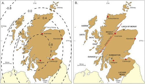
Locations of stories that plausibly represent memories of postglacial coastal submergence or emergence are shown in B. Submergence stories come from the Outer Hebrides and the Beauly and Inner Moray Firth near Inverness. The Outer Hebrides group includes sites in Lewis and Harris (the Long Island) and the Uists (North Uist, Benbecula, and nearby smaller islands). Locations of stories plausibly recalling postglacial emergence include places on islands of the Inner Hebrides (Eigg and Skye) and on the mainland adjoining Solway Firth and the Clyde Estuary as well as the Argyll lowlands northwest of Glasgow and the Laich of Moray east of Inverness.
Only stories that are recorded in more than one source and are defendable as culturally-grounded (rather than recently-invented) are included in the database; in this study, stories about St Kilda and Lismore islands are excluded from analysis even though they contain some compelling details. Excluded too are stories about giant beings striding across ocean gaps on (now-vanished) stepping stones; such stories may represent memories of times when sea level was lower and people were able to walk along these routes (Nunn et al., Citation2021) and include for Scotland crossings between Arran and Kintyre and between Mull/Staffa and Ireland by the giant Fionn MacCumhaill. Also excluded are stories with insufficient detail, such as the Shetland Islands where ‘there are numerous local traditions that submergence has continued during historic times’ (Finlay, Citation1931, p. 673) but none that could be firmly identified; and the story that the Hebridean islands of Barra and Tiree were once so close that a buarach (cow-shackle) might be tossed across the gap (Campbell, Citation1890, p. 192). Misleading etymology that was avoided includes the name Oldshore given to what might conceivably be emerged shorelines northwest of Kinlochbervie; Oldshore is actually the anglicisation of Allt-siar, the western burn/stream (Macrae, Citation1921).
3. Methods
This study utilises ancient/traditional stories from Scotland that include details about coastal change which can be interpreted as either recalling submergence (the loss of coastal fringes linked to rising ocean-water levels) or emergence (the extension of coastal fringes linked to lowered ocean-water levels. Following recent research of a similar kind in Australia and elsewhere (Nunn, Citation2018; Nunn & Reid, Citation2016), these stories can be analysed to identify the nature of the coastline they apparently recall and its level above or below the present coastline. The ages of submerged coastlines can be determined by comparing their levels to points on local-area sea-level curves (which show changes in sea level within the postglacial period) and these ages can then be used as minimum ages for the duration of the particular story and the observations (by pre-literate people) on which they are assumed to be based. The ages of emerged coastlines can be determined in a similar way.
For most of the time they existed, the stories that comprise the data for this study are all assumed to have been communicated orally, typically being translated from Gaelic and becoming written down in English by dedicated chroniclers in the nineteenth century; good examples include John Campbell’s four-volume Popular Tales of the West Highlands, published in 1860-1862, and the various well-informed contributors to The New Statistical Account of Scotland, published in 15 volumes 1834-1845. In all cases, efforts were made to identify and examine the earliest transcriptions of stories, especially as many of these were greatly altered for transcription to much larger literate audiences in the twentieth century.
Section 4 gives details of 11 Scottish stories that may plausibly represent memories of postglacial submergence. Section 5 outlines seven groups of Scottish stories that may represent memories of postglacial emergence. Section 6 evaluates the connection between stories of coastal change and models of postglacial coastal change. In Section 7, by applying methods of age determination of stories used in comparable studies, ages are estimated for each group of stories. The implications of this study are discussed in Section 8.
4. Stories of coastal submergence
Eleven stories that are each considered to be likely recollections of coastal/land submergence are recounted below; one from St Kilda is adjudged implausible.Footnote3
4.1. Outer Hebrides: Taransay and Harris
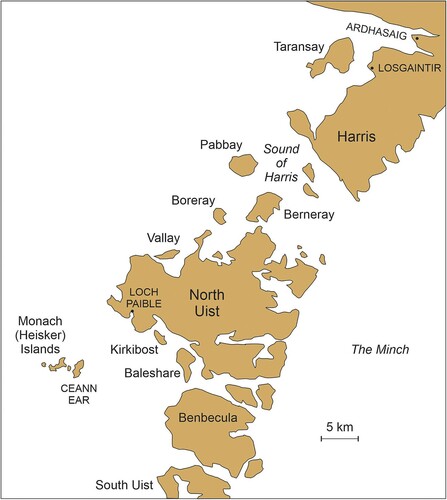
There are several traditions from the Outer Hebrides that may recall times when the sea level was lower and what are now separate islands were joined.Footnote4 One story of submergence from Harris refers to a former land connection between this island and smaller Taransay (Tarransey), now a 2-km wide ocean gap (). Around the year 1800, a story was told by an elderly man named John Maclennan, resident of Taransay, that recalled when.
‘a tongue of land from the island of Tarransey almost joined the mainland [on Harris] of Losgcinntir [Losgaintir] (Lusk’s Headland). This tongue was so broad that it took the Tarransey tenants nearly a week to plough it, and so long that Maclennan and his boy companions used to try who could best throw a stone from the point of it, across the ford, to Losgcinntir. This ford, then probably about a hundred yards wide, and one fathom deep, is now a strait one mile and a half in breadth and six fathoms in depth’ (Carmichael, Citation1886, p. 464).
Figure 2. The geography of part of the Outer Hebrides showing places mentioned in the text.
4.2. Outer Hebrides: the Uists and Benbecula
Throughout the Uists and Benbecula Island, the observed arrangement of lochs/lakes from ‘oceanic’ through a series of transitory stages to ‘fully landlocked’ demonstrates these islands’ history of submergence; or ‘subsidence’ as appeared the case to Jehu and Craig (Citation1926:, p. 473) who were writing before it was widely known that there had been fluctuations of global sea level in the past. A range of coastal-geomorphological evidence led Ritchie (Citation1966) to conclude ‘that the Uists have been submerged by a post-glacial rise in sea-level’ (p 86) while evidence of buried, often undersea, peats throughout these islands comprised evidence for ‘a probable submergence of at least 4–5 m since 8800 BP’ (Ritchie, Citation1985, p. 174). Recent research on the lochs of South Uist shows these were larger and consequently more navigable during medieval times (Angus, Citation2020, Citation2018), consistent with their subsequent submergence and/or drainage for agriculture.
4.2.a. The Monach (Heisker) islands
The five habitable islands of the Monach group (also known as Heisker or h’Eisgeir) were once quite densely populated, more than 18 families living on ‘Ceann Ear in a very small village which is provided with a missionary and and school-mistress, also with a post-office served by weekly mails from Bayhead in North Uist’ (Beveridge, Citation1911, p. 69). As today, all the larger Monach islands were then connected at ‘half tide’ but it has also been suggested that this island group was once joined to both North Uist and Benbecula islands, 8-14 km distant (). This suggestion rests in part of the derivation of the name Heisker from the Gaelic Aoi-sgeir, meaning ‘isthmus-skerry’Footnote5;
‘The isthmus was called Aoi, as similar places are still called. But, partly through the gradual subsidence of the land, and partly owing to the gradual dislodgment of the friable sand forming the isthmus, the isthmus by degrees gave way to fords, and the fords broadened into a strait four and a half miles wide and four fathoms deep. Tradition still mentions the names of those who crossed these fords last, and the names of persons drowned in crossing’ (Carmichael, Citation1884, p. 464).Footnote6
‘the people of the time tried to preserve the land, and prevent the encroachments of the sea, by constructing embankments, but the Atlantic broke down these embankments and, rushing in, filled the lakes behind, and joined the Minch [separating North Uist from Benbecula] on the other side’ (Carmichael, Citation1886, p. 466).
‘Intelligent crofters informed the writer of having seen fragments of iron bolts sunk into certain low-water rocks in the Atlantic between Benbecula and h’Eisgeir [Heisker/Monach]. These rocks lie at a distance of some miles from the land on either side, and are believed to have been the sites of embankments … It is interesting and curious to find various submerged sites over the now wide and open sea still called by their place-names, as Sgeir a Chloidhean (‘the barrier rock’, the site of a flood gate), Ceardach Ruadh (‘the red smithy’) and others’ (p 466-7).
4.2.b. Baleshare and Kirkibost
Baleshare Island lies near the coast of North Uist across from the Monach Islands. The island’s name means ‘east village’ and there may once have been a ‘west village’, now lost to the sea (Beveridge, Citation1911); there are stories about ‘the walls of ruined cottages … underwater off the western shore’ (James & Duffy, Citation2003, p. 43). More recently, local residents estimated they had experienced 20 m of shoreline recession along the Atlantic coast of Baleshare (Johnson, Citation2005).
Kirkibost Island lies a little north of Baleshare and in 1845 it was reported that, ‘being exposed to the western gales, a great part of it was literally blown away, and the sea now occupied fields which formerly produced fine crops of bear or barley’ (McRae, Citation1845, p. 163); by 1911, it was noted that Kirkibost ‘seems to have suffered greatly from encroachments by the ocean’ (Beveridge, Citation1911, p. 82).
4.2.c. Berneray and Pabbay
Pabbay Island was visited in 1697 by Martin, who noted that the western end of Pabbay was named ‘the wooden harbour’ (Mol a’ Mhaide MhoirFootnote8) because ‘the sands at low water discover several trees that have formerly grown there. Sir Norman MacLeod told me that he had seen a tree out there, which was afterwards made into a harrow’ (Martin, Citation1753, pp. 122–123).Footnote9 Similar evidence was reported by geologists Jehu and Craig (Citation1926) but is also apparent from place names. In two small bays on the north shore of Vallay Island, for example, at low tide ‘the roots and branches of trees may usually be found embedded within a layer of peat’ (Beveridge, Citation1911, p. 6); one of the bays is named Bàgh nan Craobagh or ‘bay of small trees’ (Elton, Citation1938, p. 283), plausibly a recollection of a time when it was dry land and wooded.
In 1935, the ecologist Charles Elton undertook extensive research on the islands off North Uist, combining his observations with stories told him by local residents. One such story, ‘told me personally by three different men’, was of a ‘an interesting and deeply grounded tradition among the people of Pabbay and Berneray … that in former times the two islands were only separated by a very narrow channel, so that people could shout across and be heard, or even throw things across’ (Citation1938:, p. 287).Footnote10 Elton considered that this story might be based on recollections of submergence of what is now a 3.5-km ocean gap.
In addition, the people of Boreray once grazed sheep on a now-vanished island (Eilean nan Uan) but this was ‘washed away’ and is now marked by the shoal named Oitir nan Uan (Beveridge, Citation1911, p. 52), probably today’s McIver Rocks.
Geological evidence for submergence was also deduced from the presence of peat layers exposed beneath the beaches of adjoining islands, for example across the Sound of Harris (between North Uist and Harris – Beveridge, Citation1911, p. 8) and in several places off the coast of North Uist, from which it was inferred ‘that the land must largely have extended its bounds beyond the present limits’ (MacRae, Citation1845, p. 168).Footnote11
4.3. Beauly Firth and Inner Moray Firth
One of the earliest accounts of Inverness and its surrounds notes ‘a curious tradition’ stating ‘that most part of the space, now an arm of the sea, extending from Fort-George to Beauly, was once dry land, through which the River Ness and Farar flowed, uniting their currents at the present estuary of the Ness’ (Suter, Citation1887, p. 3). In support of this, Suter noted the presence of ‘sepulchral cairns’ under the water surface of the Beauly Firth ().
Figure 3. The geography of Beauly Firth and Inner Moray Firth showing the surface expression of the Great Glen Fault (after Le Breton et al., Citation2013).
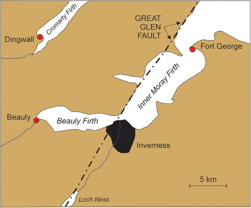
One of these may have been the ‘Black Cairn’, stated in 1875 to lie in the centre of Beauly Loch (Firth) and ‘now only visible at low tide’ (Maclagan, Citation1875, p. 89).
‘Tradition says that as late as 1745 the place was an island … The country people aver that all the land has subsided, the houses at Fort-George having sunk several feet since they were built. The fact of this crannogFootnote12 being now in the centre of Beauly Loch, the salt sea sweeping over it except at low tide, is proof enough of extensive change … Near the mouth of the river Ness, at high-water mark, are remains of a once large cairn, called ‘Carn-aire’ or ‘Cairn of the Sea’, and due west from it are [an]other three, at considerable distances apart’ (Maclagan, Citation1875, p. 89).
4.4. Synthesis of submergence data
In this section, the amount of vertical submergence implicit in each of the 11 submergence stories is identified, a necessary prerequisite to their attribution and minimum-age determination. Yet it is difficult to estimate submergence magnitudes precisely because of unknown changes in the amount of superficial sediment cover on the sea floor at particular times as well as information about palaeotidal ranges. Another source of uncertainty comes from changes in land level subsequent to the times people are said to have crossed these ocean gaps. Yet with these caveats in mind, it is possible to estimate minimum depths (relative to present mean sea level) at which each story could have been true ().
Table 1. Minimum depths calculated for stories of submergence. All data from Admiralty Bathymetry Data Service.
The depths of water gaps in Harris and the Uists can be redaily determined although, owing to the small magnitudes involved, the potential for error is greater. For example, if the minimum depth of the ocean gap between Berneray and Pabbay was 2 m rather than the estimated 5 m, then the story might be much younger than it is calculated to be.
The Beauly and Inner Moray Firths are surprisingly shallow, which lends credibility to the story that they were submerged within historical memory, but the contrast with nearby emerged areas suggests this submergence may be localized (see Section 6.2). This example also poses another source of error, namely whether stories about when a place was ‘dry land’ actually refer to its entirety or just part. In the case of the Beauly and Inner Moray, this is uncertain – like other elements of ancient oral stories, details about slight submergence may become aggrandized through time to major submergence – but obviously make a difference to the minimum depth and age estimates.
5. Stories of coastal emergence
Seven stories considered likely to be recollections of coastal emergence are recounted below; stories from Lismore are adjudged implausible.Footnote13 Locations are shown in B.
5.1. Solway Firth: Lochar Moss
In the early nineteenth century, stories of a witch named the Gyre Carline (sometimes named McNeven or NicnevenFootnote14) abounded in that part of the southern Scottish Lowlands forming the north side of Solway Firth (). A ‘celebrated personage … near akin to Satan himself’, the Gyre Carline was said to preside over the Hallowmass RadesFootnote15 and was described as ‘wearing a long gray mantle, and carrying a wand, which … could convert water into rocks, and sea into solid land’ (Cromek, Citation1810, p. 292). One instance in which the Gyre Carline is said to have been provoked refers to Lochar Moss, which formerly extended from the hill/village of Locharbriggs to the Solway Firth, and ‘was once, according to tradition, an arm of the sea, and a goodly anchorage for shipping’ (Cromek, Citation1810, p. 292).
Figure 4. Changing landscapes of the Solway Firth. A: Modern geography of the Solway Firth showing location (box) of B and C. B: Coastline 6000 years BP (after Morrison, Citation1991). C: Modern situation showing the distribution of ‘raised mires’ including Lochar Moss (after Bragg et al., Citation1984).
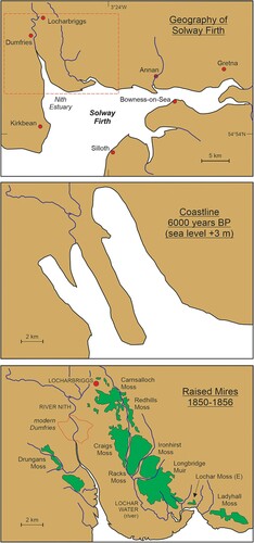
The story goes that large waves sweeping up the Lochar Moss drowned several horses belonging to the Gyre Carline who, infuriated and ‘baring her withered arm, she stretched over the sea her rod of power, and turned its high waves into a quagmire' (Cromek, Citation1810, p. 293). In his 1826 compilation of The Popular Rhymes of Scotland, Robert Chambers recorded a widely-known couplet of the time referring to Lochar Moss –
First a wudd [wood], and syne [then] a sea;
Now a moss [marsh], and aye [forever] will be.
In the 1803 Gazetteer of Scotland, referring to Lochar Moss, it is stated that ‘a stratum of sea sand is found at certain depths, with anchors, pieces of vessels, &c. which prove it has formerly been navigated’ (Anonymous, Citation1803: no page number). Cromek (Citation1810) notes that ‘boats, keels, and other remains of shipping’ have been dug up from the marsh (Lochar Moss). Similar information is given by Wood (Citation1911:, p. 8) and others.
Rather than something possibly based on their ancestors’ observations of natural change, one writer argued that local people living near Lochar Moss ‘observed stratigraphy which expressed the interaction there between land- and sea-levels: a forest had been drowned, and buried in marine clay with sea-shells; then when the mud-flats eventually emerged above sea-level, they were colonised by a peat bog’ (Morrison, Citation1991, p. 11). But it seems more likely that people, who unquestionably occupied this area at the time it was an ocean inlet, witnessed its gradual change into a ‘peat bog’ and kept their memories of this transformative event alive through the tale of the Gyre Carline and parallel folk traditions, such as that expressed in the popular early nineteenth-century couplet (above).
5.2. Inner Hebrides: Eigg and Skye
When draining a marsh (moss) at Laig on the island of Eigg, pieces of a Norse longship were found; ‘it used to be said that the whole flat was formerly a lake which the Norsemen used as a winter harbour for their galleys; while a gap in the ridges of shingle, probably an old water-channel, was pointed out as the canal by which they drew them to the lake’ (MacPherson, Citation1878, pp. 595–596). Today there is a 10-metre difference between sea level and the original harbour level (Martin & Martin, Citation2018).
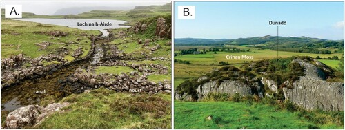
And in a more recent example, there is a partly blocked canal linking the sea with a lake (loch) on the Rubh’ an Dùnain peninsula on the Isle of Skye (Martin & Martin, Citation2018). Loch na h-Àirde is an unusually shallow (<1.5 m deep) freshwater lake joined to the sea by a canal dating from Norse times (A). Today at high tide, sea water can flow into the lake and it is inferred that the canal was designed deliberately to allow Norse boats to be floated between the lake and the sea on the high tide. Yet, as Martin and Martin (Citation2018) acknowledge,Footnote16 this preliminary interpretation may actually be too simplistic. A more nuanced one would incorporate the effects of emergence of an estimated 50 cm during the period of Norse canal usage AD 800-1200.Footnote17 For example, at the start of this period, it may well have been possible for boats to be floated into the lake but later this might have become harder because of canal shallowing, resulting in a need for portaging to get boats into the lake and/or the construction of nousts (boathouses) off the lower part of the canal to accommodate those (deeper-draft) boats that could not reach the lake. The conspicuous rock lip which exists at the entrance to the canal today may be a contemporary expression of land emergence since AD 800.
Figure 5. A: The ‘Norse canal’ and a noust (boathouse) at Loch na h-Àirde (Skye, Inner Hebrides) (photo with permission of Tom Gardner). B: Dunadd (Argyll), the site of a once ocean-encircled hillfort, looking northwards (photo: Wikimedia Commons, Geograph Project).
At the north end of the island of Skye is the landlocked bed of an ancient lake (lochFootnote18) named St Columba’s Loch or Loch-Chaluim-Chille that once formed a coastal bay, as suggested by the ‘well-marked sea-beach existing on the coast and running around the loch’ (Jolly, Citation1875, p. 552). While it now lies around 7-15 m above sea level, the likelihood that it was connected to the sea during an earlier period of human occupation of the region is suggested by the discovery in lake-floor sediments of the remains of several boats that would appear, from extant descriptions, to have been the kind that would have been ocean-going rather than lake-going (Jolly, Citation1875). It is probable that, as for Loch na h-Àirde (above), these boats were once regularly kept here – a safe harbour – when not needed for travel between islands. After the land emerged and the lake-sea passage became impassable, the boats were stranded within the lake, their remains gradually incorporated into lake sediments. This scenario is consistent with the 1763 discovery of a logboat at Loch-Chaluim-Chille, about 1 km from the sea and some 15 m above its level; this boat was ‘deeply imbedded in the bottom of the lake’ and fastened to its ends were five iron rings that appeared ‘of almost incredible thickness’ to the excavators who reworked them into agricultural tools (Mowat, Citation1996; Jolly, Citation1875).Footnote19
5.3. Dunadd and Dumbarton Rock
It seems clear that the ancient forts (dun) at Dunadd and Dumbarton Rock were both established when their elevated rocky sites were islands surrounded by the ocean. Since then the land emerged, transforming the landscape and reducing the natural defensive attributes of these forts (Lathe & Smith, Citation2015).
Dunadd is a conspicuous outcrop of metamorphic rock rising 55 m above the peat flats of Crinan Moss (B) that was first occupied and fortified around 300 BC and saw a succession of later occupations until at least the eighth century AD (Lane & Campbell, Citation2000). Today Dunadd is some 4 km from the coast and 2 km from the navigable tidal reaches of the River Add, making it an unlikely site for a fort and adding to the likelihood that the area has emerged within the past 2300 years or so. Modelling of land uplift, supported by radiocarbon ages from Crinan Moss sediments, suggest Dunadd emerged from the sea between AD 460-770. Given this and the attendant loss of Dunadd’s key defensive attribute, it is perhaps no surprise that it was besieged in AD 683 and taken by the Picts in AD 736 (Lathe & Smith, Citation2015).
Dumbarton Rock is similarly situated, a volcanic plug rising 73 m above the modern Clyde estuary, the site of the fifth-century AD fort of Dùn Breatainn (Fortress of the Britons) that was seized by the Norse in AD 870 (Alcock, Citation1976). That this latter event was made easier by the emergence of the land around the Rock, meaning it could be approached in foot rather than just by boat, appears probable. Historical records suggest that around AD 1420, these flats were all dry at low tide (Lathe & Smith, Citation2015).
5.4. The Laich of Moray
The elongate area of lowland named the Laich of Moray lies just inland of the cliffed coast forming part of the southern shore of the Moray Firth (see C). This lowland was formerly an ocean inlet named Loch Spynie. Some time between approximately AD 1460 and AD 1580, when the earliest maps of the area were made, the connection between Loch Spynie and the ocean closed, paving the way for the area’s drainage and creation of the fertile Laich of Moray (Stratigos, Citation2020).Footnote20
Figure 6. Changing landscapes of the Burghead-Lossiemouth area, northeast Scotland. A: Plausible reconstruction of the coastline of the area when sea level was 5-10 m lower, possibly around the time of early Norse arrival. B: Medieval geography showing Loch Spynie (after Stratigos, Citation2020, Citation2018). C: Modern geography showing the Laich of Moray and major towns.
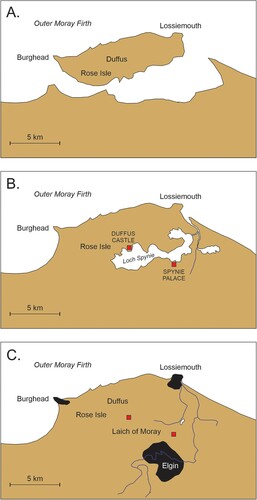
There are written records, based on oral traditions, of how Loch Spynie was used when it was connected to the ocean. For example, when the Norse established themselves at Burghead in AD 884, their ships anchored within Loch Spynie; this was then ‘an inlet of the sea extending to Rose Isle which, being then a forest, the invaders built vessels at, and compelled the inhabitants to assist them in their labours’ (Young, Citation1871, p. 5).Footnote21 It has also been suggested that as early as AD 884 the Norse were able, perhaps through the cutting of a canal, to sail all the way around the Burghead-Lossiemouth island (A).Footnote22 By medieval times (B), when the first maps and detailed written descriptions of the area were made, any direct connection with Burghead had closed and there existed Loch Spynie, draining west to a point south of modern Lossiemouth. The modern geography of the area is shown in C.
5.5. Synthesis of emergence data
It is more difficult to estimate accurate submergence magnitudes from ancient stories than to calculate precise emergence magnitudes because the sources of potential error are fewer and lesser in degree. Yet clearly assumptions have to be made about the amount of sediment cover a particular surface had when it was undersea compared to today when it is above-sea. With this in mind, emergence magnitudes and associated caveats are given in for each of the stories recounted earlier in Section 5.
Table 2. Vertical elevations calculated for stories of emergence. Data from Ordnance Survey MasterMap.
Most stories involve emergence magnitudes of 0.5-15 m which are not conspicuously misaligned with other estimates of postglacial emergence in Scotland (Smith et al., Citation2006; Firth & Stewart, Citation2000).
6. Matching ancient stories to coastal change: testing their authenticity
To test whether or not the spatial distribution of submergence and emergence stories matches the behaviour of the land surface within the postglacial period, the empirical approach developed by Smith et al. (Citation2006) is used. This involved measuring the current elevations of emerged postglacial shorelines across Scotland, specifically the heights of the reconstructed Wigtown and Blairdrummond shorelines ().
Figure 7. Trend surfaces (after Smith et al., Citation2020) showing the approximate elevations (m) of (A) the Blairdrummond Shoreline (5800-4500 years BP) and (B) the Wigtown Shoreline (3700-1520 years BP). Gaussian quadratic trend surface models are based on Smith et al. (Citation2019, Citation2012). Red place names represent locations of submergence stories; blue place names represent those of emergence stories.
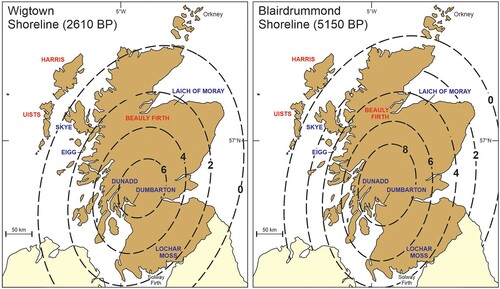
The maps in show the trend surfaces of the Wigtown and Blairdrummond shorelines, dating to around 2610 and 5150 BP respectively, and the locations of the 11 submergence stories and seven emergence stories.
6.1. Matching signs of vertical movement
With the exception of the Beauly and Inner Moray Firths story, all submergence stories fall outside the areas of emergence represented by the Wigtown and Blairdrummond shorelines, suggesting that they are geographically aligned with areas of submergence during the ∼5000 years of land-level changes represented by these shorelines. On account of its anomalous sign, the case study of the Beauly and Inner Moray Firths is discussed separately in Section 6.2.
The alignment of submergence stories with places that have experienced submergence () within the second half of the Holocene period is remarkable. It demonstrates the likelihood that these stories are all genuine memories – representing eyewitness accounts – of land becoming submerged. This deduction is also supported by the converse, namely both an absence of submergence stories from areas that have emerged and an absence of emergence stories from areas that have been submerged. Critics may propose that the alignment is a result of cherrypicking but the data is available for anyone to discover and interrogate.
The alignment of emergence stories with places that have risen within the past 5000 years or so is perfect for both the Wigtown and Blairdrummond shorelines (), again adding weight to the proposition that all these stories are authentic recollections of coastal change, founded on people’s observations of land emergence, that endured in largely oral contexts for at least five millennia.
6.2. The Beauly and Inner Moray firths: evidence for localized submergence?
The story about submergence of the Beauly Firth and Inner Moray Firth (see Section 4.3) opposes that for emergence of adjacent areas, particularly the Laich of Moray (Section 5.5) and the evidence from the upper end of Cromarty Firth (location shown in ) where the thirteenth-century harbour at Dingwall is now 2 km inland from the shore.Footnote23 While it could conceivably echo this area’s earlier history of submergenceFootnote24, the Beauly-Inner Moray anomaly might also be explained by tectonic subsidence associated with movement along the Great Glen Fault which, despite being an ancient feature along which strike-slip faulting ceased to be effectively accommodated in the late Tertiary, may have exhibited signs of minor activity within postglacial times (Piccardi, Citation2014; Stewart et al., Citation2001) that help explain folk traditions of the Loch Ness Monster as well as sightings of ‘mythical beasts’ in comparable geotectonic contexts. In support of this possibility, it is noted that the nearby Highland Boundary Fault, also an ancient feature, has also experienced recent minor activity (Ottemöller & Thomas, Citation2007).
There are two key factors to consider. First is that glacio-isostatic readjustment (GIA) can trigger the reactivation of ancient faults, something that can persist in situations where faults are appropriately aligned with the new stress regimes; the Kinloch Hourn Fault exemplifies the situation (Stewart et al., Citation1999).Footnote25 Second is that, while many envisage the GIA process as being manifested by (slow) regional crustal deformation, there is growing evidence that in places it was also accommodated by block uplift and subsidence; the situation at two sites in western Scotland and in various parts of (glaciated) northwest Ireland provide compelling examples (Ballantyne et al., Citation2013; Stoker & Bradwell, Citation2009; Smith et al., Citation2009). With this in mind, it is possible that postglacial subsidence of a few metres in the Beauly Firth and Inner Moray Firth may have occurred as a result of postglacial subsidence/slumping along the Great Glen Fault that runs along their northwest sides (see ) and explains the stories of submergence recounted in Section 4.3. Alternatively it may simply be that this narrative is incorrect – and that there is therefore perfect agreement between the ancient stories database and the distribution of coastal submergence or emergence within the past few millennia.
7. Story ages
Ages can be estimated for ‘ancient stories’ of the kinds described above, typically using radiometric dates for contemporaneous phenomena. This is least controversial with catastrophic volcanic events, such as the terminal eruptions of Mt Mazama (USA) and Santorini (Greece) 7600 and 1620 cal BP respectively (Egan et al., Citation2015; Friedrich et al., Citation2006), but has also been used to estimate ages for stories about meteorite impacts and coastal land loss attributable to postglacial sea-level rise (Nunn & Reid, Citation2016; Hamacher & Norris, Citation2009).
In the latter case, ‘submergence stories’ from Australia (where the ocean surface reached present sea level about 7000 BP) were analysed to identify the most recent time (shallowest depth) at which they would have been valid. This depth was then compared to the postglacial sea-level curve and a minimum age for the story estimated (Nunn, Citation2018; Nunn & Reid, Citation2016). The same approach is used to determine minimum ages for submergence stories from Scotland. A comparable approach is used to determine ages for ‘emergence stories’ from Scotland.
For both submergence and emergence stories, ages are estimated from the site-specific outputs of relative sea-level (RSL) change from two contrasting GIA models as shown in . The ‘Bradley2017’ model (Shennan et al., Citation2018) has a higher grid resolution than earlier iterations while the ‘Kuchar2012’ (Kuchar et al., Citation2012) model has a slightly different quantitative basis. shows ages for each site calculated from both curves.
Figure 8. Reconstructions of postglacial relative sea-level change histories for the case-study sites. Note that vertical and horizontal axes vary. In all, the solid (blue) lines refer to the Bradley2017 curve and the dashed (red) lines refer to the Kuchar2012 curve (in Shennan et al., Citation2018). Graph A derives from the ‘Hebrides’ curves (#7 in of Shennan et al., Citation2018) and includes sea-level reconstructions (dotted lines) for two points 80 km west of South Uist (Lambeck, Citation1995). Graph B derives from the Skye curves (#8 in Shennan et al., Citation2018); Graph C from the Moray Firth curves (#5); Graph D from the NE Scotland curves (#13); Graph E from the Knapdale curves (#54); Graph F from the Clyde curves (#20); and Graph G from the NE Solway Firth curves (#28).
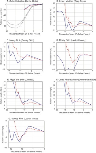
Minimum ages for all submergence stories are all Holocene in age, ranging from 2107–8695 years BP (A), well within the time range of similar submergence stories from Australia and elsewhere (Nunn & Cook, Citation2022; Nunn, Citation2018).
Ages for emergence stories are also all Holocene, ranging from 674–7120 years BP. In the case of Dunadd, this approach produces similar ages to historical estimates; an estimated age of 2824 BP (or 874 BC) compared to that for the earliest fort of circa 300 BC (Lathe & Smith, Citation2015) may suggest, not unreasonably, that stories of the area’s emergence predated fort construction by perhaps some six centuries. At Dumbarton Rock, the earliest-known fort was constructed in the fifth century AD but it is likely that the (undoubtedly memorable) emergence of this steep-sided volcanic plug from the Clyde River estuary was a common topic for oral traditions in the area far earlier, perhaps originating around 916 BC (2866 BP) as suggested by the analysis in .
Table 3. Age estimates for submergence and emergence stories calculated from relative sea-level outputs of GIA models ().
Table 4. Emergence rates from narrative and geological sources compared. All emergence rates in m/1000 yr.
This approach clearly overestimates the period of Norse use of canals within the Inner Hebrides (Eigg and Skye) and the possible Norse use of an extended Loch Spynie (as in A) but perhaps also signals the likely existence of stories/traditions referring to pre-Norse uses of these sites that became incorporated into stories about their more recent histories. This is a radical suggestionFootnote26 but one that is strengthened by the conclusion of David Nance, writing about stories of the celestial foundation of the Calanais Stones (Isle of Lewis) that ‘the study strongly suggests that oral history records celestial events and can persist over long periods through language transitions’ (Citation2021:, p. 22).
It is worth noting that there is a cultural historical geography to such stories in that, having moved across time and space, they acquired elements that have become the basis for uncertainty, whether these involve fabulous beings or links to places to which stories were carried (by migrants) rather than those where the observations on which they are based were made.
Another test of the alignment between estimates of land emergence from narrative sources and scientific reconstruction is one that compares land-uplift rates. For Scotland, the most meaningful science-based analogue to (empirically-derived) narrative-based estimates of land uplift is the (empirically-derived) reconstruction of ancient shorelines, namely the Wigtown and Blairdrummond Shorelines mapped by Smith et al. (Citation2006) and illustrated in .
8. Conclusion
Modern humans occupied central and northeast Scotland as early as 14,500 BP, spreading around most of its fringes, including the Hebrides, within the next two millennia (Hardy et al., Citation2021; Ballin, Citation2017). It is clear that people witnessed land submergence and emergence during the late Pleistocene and Holocene and it is plausible to suppose that their observations would have become encoded, as elsewhere, into enduring oral traditions passed on across many generations. This study argues that, as elsewhere, some such oral traditions survived until today, largely through oral means but becoming written down typically within the past 200–300 years. Although this proposition has parallels in Australia, this is the first time it has been systematically suggested for Scotland, so it is worth discussing some common objections before reiterating the key arguments in its favour.
Many literate people greatly underestimate both the breadth, volume and longevity of knowledge acquired, stored and communicated in oral (pre-literate) contexts because they uncritically measure the cognitive abilities of people in such contexts by their own literate situations. Yet literate people have no need to remember huge amounts of information because they can read it (or ‘look it up’) and therefore find it difficult to believe that their pre-literate ancestors would have been any different, something referred to as ‘the arrogance of literacy’ (Nunn, Citation2018). Empirical evidence in support of the counter argument is well documented (e.g. Sugiyama et al., Citation2020; Lilomaiava-Doktor, Citation2020) and it has been further argued that a full appreciation of oral knowledges is key not just to properly understanding human pasts but also to the optimal management of human futures (Lam et al., Citation2020; Katerere, Citation2020; Yunkaporta, Citation2019; Kelly, Citation2015).
This study analysed 11 groups of submergence stories and seven groups of emergence stories, each of which is considered likely to have originated as long-standing oral traditions among people of the area to which the stories refer. Analysis shows that – with one exception – all stories correctly match the sign of actual movement of the land-sea interface, which supports the idea they represent memories of empirical observations of this movement.
Using various methods, ages were estimated for each group of stories, most submergence stories dating to 2107–8695 BP and most emergence stories to 674–7120 BP. These ranges align well with age estimates for comparable narratives in Australia and elsewhere, including those about the Henbury meteorite falls (4200 BP – central Australian desert), the separation of the Wellesley Islands from the mainland (7450 BP – northeast Australia), the Osceola Mudflow from Mt Rainier (5600 BP – northwest USA), and the memorable eruptions of Kinrara volcano (∼7000 BP – northern Australia) and Mt Mazama in Oregon (7600 BP – western USA) (sources in Nunn, Citation2018). To this list can be added the construction and purposeful alignment with Venus of the Calanais Stones on the Isle of Lewis 3627 BP (Nance, Citation2021).
It is hoped that this work will encourage more widespread and systematic interrogation of ancient traditions in Scotland and elsewhere. One question of particular interest to which a more complete compilation and analysis of stories would be germane is that concerning the shifting ‘hinge line’ in western Scotland between areas of postglacial emergence and submergence; it is possible that Hebridean traditions have the potential to refine model outputs. Another place where such research might illuminate postglacial changes in the land-sea interface would be the Orkney and Shetland island groups where there are vast repositories of oral traditions.
Acknowledgements
Sincere thanks to Dr Robert Hay, Archivist of the Lismore Historical Society, for his help with understanding Eirebol traditions and to Dr Michael Stratigos (University of York) for information regarding the history of Loch Spynie. For various insights and clarifications, the author is also grateful to Professor David E. Smith (University of Oxford), Dr Natasha Barlow (University of Leeds), Professor Colin Ballantyne (University of St Andrews) and Dr Tom Gardner (Historic Environment Scotland). As a result of detailed comments by two anonymous referees, the first draft of this paper was markedly improved - Mòran taing airson do chuideachadh.
Disclosure statement
No potential conflict of interest was reported by the author(s).
Correction Statement
This article has been corrected with minor changes. These changes do not impact the academic content of the article.
Notes
1 In this study, submergence refers to relative sea-level rise while emergence refers to relative sea-level fall; neither term implies any particular cause. In contrast, the term subsidence is used to refer to a sinking of land (relative to the Earth’s centre) and uplift refers to its elevation.
2 The last time that Scotland was covered with an ice sheet was during the Dimlington Stade, approximately 31,000-14,700 years BP. At its fullest extent, this ice sheet merged with the Fennoscandian ice sheet to the east in the North Sea Basin and, to the west, extended across the Atlantic continental shelf (Ballantyne & Small, Citation2019).
3 The earliest written account of the island and people of outlying St Kilda Island was in the year 1697 by Martin (Citation1753) and included a tradition of a female warrior who once lived above West Bay and “was much addicted to Hunting, and that in her Days all the Space betwixt this Island and that of Harries [Harris], was one continued Tract of Dry Land” across which when hunting deer she would loose her greyhounds “making their Course towards the opposite Isles” (p 15). A comparable story is known from the island of Harris, 90 km east of St Kilda, where, “according to local tradition, land is said at one time to have linked St Kilda with the Long Island [Harris-Lewis] … the hunting-ground of a former Princess of Harris” (Jehu & Craig, Citation1926, p. 474).
4 A global review of this was published recently (Nunn & Cook, Citation2022).
5 Skerry is a Scottish word for a rocky island too small to be habitable by people. The other name for Heisker is Monach, from eilean nam manach or ‘island of the monks’, a reference to the monastery that once existed there.
6 Carmichael also speculated that Iona Island was once joined to neighbouring Mull Island, given that the probable etymology of Iona is from Aoi Chalum Chille (Isle of Columba of the Churches); “perhaps there was less subsidence of land, but that a sandy isthmus connected Iona with the opposite shore of Mull must be evident to any person who examines the place at low water” (Carmichael, Citation1884, pp. 464–5).
7 The historical drying-up of Loch Paible (Phaibeil) was caused by both its intentional draining in the 18th century and the breaching of its beach-dune barrier (Dig Mhór) by a ‘high tide’, likely amplified by coastal submergence.
8 Gaelic name reported by Elton (Citation1938:, p. 284) and translated as ‘bay with large trees (or timber)’.
9 A comparable observation was made off western Pabbay some hundred years later; “where the sea ebbs out in spring tides to a great distance, there are visible, at the very lowest ebb, large trunks of trees; the roots of which, spread out widely and variously, are fixed in black moss, which might be dug for peat to a great depth” (Sinclair, Citation1794, Volume 10: 373-374).
10 A comparable story is that the distance between Pabbay and Boreray islands was formerly so small that “a wife could throw her washboard across the channel between them” (Haswell-Smith, Citation2004, p. 271).
11 MacRae continued; “This is still less doubtful from the fact that, several miles from the shore, moss is taken up on the flakes of anchors, where, covered by the sea, it could never have grown” (p 168).
12 A crannog is a word used for both an artificial island, usually within a lake, or a dwelling upon it. It is possible that Maclagan here uses ‘crannog’ to simply mean submerged island, given its diagnostic structure was obscured.
13 On the elongate island of Lismore (Lios Mòr) in fault-controlled Loch Linnhe, close to Coeffin (Caifean) Castle, there are two separate flat-topped summits, the Greater Eirebal and the Lesser Eirebal that must once “have formed two islands, flat and green on the top” (Campbell, Citation1885, p. 330). Support for this lies in the deconstruction of the name Eirebol, proposed by Henderson (Citation1910:, p. 65) to derive from the Norse eyrr-bol (beach-stead), eyrr being island, bol referring to new land. Campbell (Citation1885) refers to traditions that the Eirebols were used as burial grounds, perhaps in this case as that of the Princess Bheothail who cried in her grave until her remains were disinterred and returned to her home in Scandinavia. Dr Robert Hay of the Lismore Historical Society suggests the Eirebols may have been islands as recently as AD 1000 (Personal Communication, May 2021).
14 The female patronymic ‘Nic’ means ‘daughter of’ in Scottish Gaelic (Simpson, Citation1995).
15 Wild horseback hunts ‘when out the hellish legion sallied’ (Robert Burns, 1790 poem, Tam o’ Shanter).
16 “This observation may require modification if evidence of past sea-level change becomes available” (p 147).
17 Emergence data from (8) in Shennan et al. (Citation2018); Norse settlement ages from Sharples (Citation2016).
18 In the past, the Scottish term ‘loch’ was applied to both freshwater lakes and to (elongate) ocean inlets.
19 Later discoveries of boats here in 1874-5, described by Jolly, were of ‘canoes’, hollowed-out from tree trunks and probably for conveying people across the lake when there was water within it. But the 1763 discovery, according to an informant with intimate knowledge of it, was of a Currach-fiodha; as Jolly points out (p 554), a currach is a boat made from ‘wattled work and hide or skins, anciently used’ but fiodha is wood. Thus this boat was a logboat of the kind used (and sometimes harboured in inland lochs) by the Norse settlers of the Hebrides.
20 This age range refines the estimate of Stratigos (Citation2020) with the evidence from baronial regulation of ocean fisheries around AD 1451 that Loch Spynie was still connected to the sea in this year, when the mouth was ‘closing up gradually’ (Young, Citation1871, pp. 6–7). As the latter notes, “when the lake became shallower, and unfitted for navigation, it would become an object to the Bishops, its then almost sole proprietors, to exclude the sea entirely, reduce its waters, and attempt to gain land by drainage” (p 8).
21 The palaeogeographic evolution of this area is not fully understood.
22 “It is not unlikely that the inlet of the sea [south of Rose Isle] existed at the time of the Danish [Norse] invasion, and if so, the forming of a trench across the Isthmus, and introducing salt water into the ditch, so as to make Burghead an island, would have been a comparatively easy matter. The coast is so changed here, even within the last 150 years, that it is now difficult to form an opinion of what its early appearance must have been” (Young, Citation1867, p. 21).
23 The medieval burgh of Dingwall was established in AD 1226 but its harbour and shorefront became increasingly distant from the sea in Cromarty Firth (Macrae, Citation1923).
24 Approximately 7000-11,000 years BP – see Figure 8C.
25 Movement along this fault may have triggered the 12th November 2018 Loch Quioch landslide (tinyurl.com/dfhfprdd) that cut off power to 17,000 people in the West Highlands of Scotland.
26 The suggestion may be radical in this context but it is not novel. For example, the medievalist Rachel Bromwich, writing about Welsh stories of submerged lands, concluded that “it is to representatives drawn from among the famous legendary heroes of the sixth century, the period assigned to the beginning of their national traditions, that medieval cyfarwyddiaid [storytellers] attached the legends of the [earlier] great inundations” (Citation1950:, p. 241).
References
- Alcock, L. (1976). A multi-disciplinary chronology for Alt Clut, Castle Roack, Dumbarton. Proceedings of the Society of Antiquaries of Scotland, 6, 103–113.
- Angus, S. (1997). The Shaping of the Islands - The Outer Hebrides. Cambridge.
- Angus, S. (2018). The aquatic context of Caisteal Ormacleit, South Uist, Outer Hebrides. Proceedings of the Society of Antiquaries of Scotland, 147, 243–259. https://doi.org/10.9750/PSAS.147.1246
- Angus, S. (2020). Clanranald’s inland Uist waterway. Proceedings of the Society of Antiquaries of Scotland, 149, 7–24. https://doi.org/10.9750/PSAS.149.1274
- Anonymous. (1803). The Gazetteer of Scotland. Ray.
- Ballantyne, C. K., & Small, D. (2019). The last Scottish ice sheet. Earth and Environmental Science Transactions of the Royal Society of Edinburgh, 110(1-2), 93–131. https://doi.org/10.1017/S1755691018000038
- Ballantyne, C. K., Wilson, P., Schnabel, C., & Xu, S. (2013). Lateglacial rock slope failures in north-west Ireland: Age, causes and implications. Journal of Quaternary Science, 28(8), 789–802. https://doi.org/10.1002/jqs.2675
- Ballin, T. B. (2017). Rising waters and processes of diversification and unification in material culture: The flooding of Doggerland and its effect on north-west European prehistoric populations between ca. 13 000 and 1500 cal BC. Journal of Quaternary Science, 32(2), 329–339. https://doi.org/10.1002/jqs.2834
- Barber, E. W., & Barber, P. T. (2004). When They Severed Earth From Sky: How The Human Mind Shapes Myth. Princeton University Press.
- Beveridge, E. (1911). North Uist, Its Archaeology and Topography. William Brown.
- Bradley, S. L., Milne, G. A., Shennan, I., & Edwards, R. (2011). An improved glacial isostatic adjustment model for the British isles. Journal of Quaternary Science, 26(5), 541–552. https://doi.org/10.1002/jqs.1481
- Bragg, O. M., Lindsay, R. A., & Robertson, H. (1984). A historical survey of lowland raised mires. Nature Conservancy Council.
- Bromwich, R. (1950). Cantre'r Gwaelod and Ker-Is. In C. Fox, & B. Dickens (Eds.), The Early Cultures of North-West Europe (pp. 217–241). Cambridge University Press.
- Campbell, A. (1885). Records of Argyll: Legends, Traditions, and Recollections of Argyll Highlanders. Blackwood.
- Campbell, J. F. (1890). Popular Tales of the West Highlands. Gardner.
- Carmichael, A. (1884). Grazing and agrestic customs of the Outer Hebrides (Appendix A (XCIX)). In H. Majesty's Commissioners of Inquiry (Ed.), Report into the Condition of the Crofters and Cottars in the Highlands and Islands of Scotland (pp. 451–482). Neill.
- Carmichael, A. (1886). The place-names of Iona. Scottish Geographical Magazine, 2(8), 461–474. https://doi.org/10.1080/14702548608554496
- Carto, S. L., Weaver, A. J., Hetherington, R., Lam, Y., & Wiebe, E. C. (2009). Out of Africa and into an ice age: On the role of global climate change in the late Pleistocene migration of early modern humans out of Africa. Journal of Human Evolution, 56(2), 139–151. https://doi.org/10.1016/j.jhevol.2008.09.004
- Chambers, R. (1826). The Popular Rhymes of Scotland. Hunter.
- Cohen, B. E., Mark, D. F., Fallon, S. J., & Stephenson, P. J. (2017). Holocene-Neogene volcanism in northeastern Australia: Chronology and eruption history. Quaternary Geochronology, 39, 79–91. https://doi.org/10.1016/j.quageo.2017.01.003
- Cracknell, B. E. (2005). Outrageous Waves: Global Warming and Coastal Change in Britain through Two Thousand Years. Phillimore.
- Cromek, R. H. (1810). Remains of Nithsdale and Galloway Song: with historical and traditional notices relative to the manners and customs of the peasantry. Cadell and Davies.
- Deur, D. (2002). A most sacred place: The significance of Crater Lake among the Indians of southern Oregon. Oregon Historical Quarterly, 103(1), 18–49.
- Duck, R. (2011). This Shrinking Land: Climate Change and Britain's Coast. Dundee University Press.
- Egan, J., Staff, R., & Blackford, J. (2015). A high-precision age estimate of the Holocene Plinian eruption of Mount Mazama, Oregon, USA. The Holocene, 25(7), 1054–1067. https://doi.org/10.1177/0959683615576230
- Elton, C. (1938). Notes on the ecological and natural history of Pabbay, and other islands in the Sound of Harris, Outer Hebrides. The Journal of Ecology, 26(2), 275–297. https://doi.org/10.2307/2256248
- Finlay, T. M. (1931). XXVII.—The Old Red Sandstone of Shetland. Part II. North-western area. Transactions of the Royal Society of Edinburgh, 56(3), 671–694. https://doi.org/10.1017/S0080456800016537
- Firth, C. R., & Stewart, I. S. (2000). Postglacial tectonics of the Scottish glacio-isostatic uplift centre. Quaternary Science Reviews, 19(14-15), 1469–1493. https://doi.org/10.1016/S0277-3791(00)00074-3
- Fox-Kemper, B., Hewitt, H. T., Xiao, C., Aðalgeirsdóttir, G., Drijfhout, S. S., Edwards, T. L., Golledge, N. R., Hemer, M., Kopp, R. E., Krinner, G., Mix, A., Notz, D., Nowicki, S., Nurhati, I. S., Ruiz, L., Sallée, J.-B., Slangen, A. B. A., & Yu, Y. (2021). Ocean, cryosphere and sea level change. In V. Masson-Delmotte, P. Zhai, A. Pirani, S. L. Connors, C. Péan, S. Berger, N. Caud, Y. Chen, L. Goldfarb, M. I. Gomis, M. Huang, K. Leitzell, E. Lonnoy, J. B. R. Matthews, T. K. Maycock, T. Waterfield, O. Yelekçi, R. Yu, & B. Zhou (Eds.), Climate Change 2021: The Physical Science Basis. Contribution of Working Group I to the Sixth Assessment Report of the Intergovernmental Panel on Climate Change (pp. 1211–1362). Cambridge University Press.
- Friedrich, W. L., Kromer, B., Friedrich, M., Heinemeier, J., Pfeiffer, T., & Talamo, S. (2006). Santorini eruption radiocarbon dated to 1627-1600 B.C. Science, 312(5773), 548–548. https://doi.org/10.1126/science.1125087
- Gehrels, W. R. (2010). Late Holocene land- and sea-level changes in the British isles: Implications for future sea-level predictions. Quaternary Science Reviews, 29(13-14), 1648–1660. https://doi.org/10.1016/j.quascirev.2009.09.015
- Hamacher, D. W., & Norris, R. P. (2009). Australian Aboriginal geomythology: Eyewitness accounts of cosmic impacts? Archaeoastronomy, 22, 60–93.
- Hardy, K., Ballin, T., & Bicket, A. (2021). Rapidly changing worlds. Finding the earliest human occupations on Scotland's north-west coastline. Quaternary International, 584, 106–115. https://doi.org/10.1016/j.quaint.2020.10.060
- Haswell-Smith, H. (2004). The Scottish Islands: A comprehensive guide to every Scottish island. Canongate Books.
- Henderson, G. (1910). The Norse Influence on Celtic Scotland. Maclehose.
- Huang, C. C., Zhao, S., Pang, J., Zhou, Q., Chen, S., Li, P., Mao, L., & Ding, M. (2003). Climatic aridity and the relocations of the Zhou culture in the Southern Loess Plateau of China. Climatic Change, 61(3), 361–378. https://doi.org/10.1023/B:CLIM.0000004550.82862.72
- James, H. F., & Duffy, A. (2003). Excavations at Baleshare. In J. Barber (Ed.), Bronze Age Farms and Iron Age Farm Mounds of the Outer Hebrides (pp. 43–71). Society of Antiquaries of Scotland.
- Jehu, T. J., & Craig, R. M. (1926). X.—Geology of the Outer Hebrides. Part III.—North Uist and Benbecula. Transactions of the Royal Society of Edinburgh, 54(2), 467–489. https://doi.org/10.1017/S0080456800027678
- Johnson, M. (2005). Coastal zone assessment survey: North Uist. SCAPE Trust for Historic Scotland.
- Jolly, W. (1875). St Columba’s Loch, in Skye, and its ancient canoes. Proceedings of the Society of Antiquaries of Scotland, 11, 551–561.
- Katerere, D. R. (2020). Traditional and Indigenous Knowledge for the Modern Era: A natural and applied science perspective. CRC Press.
- Kavil, S. P. (2021). Climate change and the migration of a pastoralist people c. 3500 cal. Years BP inferred from palaeofire and lipid biomarker records in the montane Western Ghats, India. Environmental Archaeology.
- Kelly, L. (2015). Knowledge and Power in Prehistoric Societies: Orality, memory and the transmission of culture. Cambridge University Press.
- Kuchar, J., Milne, G., Hubbard, A., Patton, H., Bradley, S., Shennan, I., & Edwards, R. (2012). Evaluation of a numerical model of the British-Irish ice sheet using relative sea-level data: Implications for the interpretation of trimline observations. Journal of Quaternary Science, 27(6), 597–605. https://doi.org/10.1002/jqs.2552
- Lam, D. P. M., Hinz, E., Lang, D. J., Tengo, M., von Wehrden, H., & Martin-Lopez, B. (2020). Indigenous and local knowledge in sustainability transformations research: A literature review. Ecology and Society, 25(1), 3. https://doi.org/10.5751/es-11305-250103
- Lambeck, K. (1995). Glacial isostasy and water depths in the late Devensian and Holocene on the Scottish shelf west of the Outer Hebrides. Journal of Quaternary Science, 10(1), 83–86. https://doi.org/10.1002/jqs.3390100109
- Lane, A., & Campbell, E. (2000). Dunadd: An Early Dalriadic Capital. Oxbow Books.
- Lathe, R., & Smith, D. (2015). Holocene relative sea-level changes in western Scotland: The early insular situation of Dun Add (Kintyre) and Dumbarton Rock (Strathclyde). The Heroic Age: A Journal of Early Medieval Northwestern Europe, 16, 1–12.
- Le Breton, E., Cobbold, P. R., & Zanella, A. (2013). Cenozoic reactivation of the Great Glen Fault, Scotland: Additional evidence and possible causes. Journal of the Geological Society, 170(3), 403–415. https://doi.org/10.1144/jgs2012-067
- Lilomaiava-Doktor, S. (2020). Oral traditions, cultural significance of storytelling, and Samoan understandings of place or fanua. Native American and Indigenous Studies, 7(1), 121–151. https://doi.org/10.5749/natiindistudj.7.1.0121
- Maclagan, C. (1875). The hill forts, stone circles and other structural remains of ancient Scotland. Edmonston & Douglas.
- MacPherson, N. (1878). Notes on antiquities from the Island of Eigg. Proceedings of the Society of Antiquities of Scotland, 12, 577–597.
- Macrae, A. (1921). Kinlochbervie. Highland Christian Literature Society.
- MacRae, F. (1845). Parish of North Uist. In J. Sinclair (Ed.), The New Statistical Account of Scotland (pp. 159–181). Blackwood and Sons.
- Macrae, N. (1923). The romance of a royal burgh: Dingwall's story of a thousand years. North Star.
- Martin, C., & Martin, P. (2018). Rubh’ an Dùnain: A multi-period maritime landscape on the isle of Skye, Inner Hebrides, Scotland. International Journal of Nautical Archaeology, 47(1), 140–158. https://doi.org/10.1111/1095-9270.12267
- Martin, M. (1753). A Voyage to St Kilda. 4th ed. Browne and Davis.
- Masse, W. B. (2007). The archaeology and anthropology of Quaternary period cosmic impact. In P. T. Bobrowsky, & H. Rickman (Eds.), Comet/Asteroid Impacts and Human Society (pp. 25–70). Springer.
- Morrison, I. A. (1991). Galloway: Locality and landscape evolution. Scottish Society for Northern Studies, 28, 1–16.
- Mowat, R. J. C. (1996). The Logboats of Scotland, with notes on related artefact types, Oxbow Monograph Series. Oxbow Books.
- Nance, D. A. (2021). A Calanais myth and an alignment of the east stone-row with both the rising of the Pleiades and crossovers of Venus at sunrise on the summer solstices. Scottish Geographical Journal, 137(1-4), 41–66. https://doi.org/10.1080/14702541.2021.1905871
- Nunn, P. D. (2009). Vanished Islands and Hidden Continents of the Pacific. University of Hawai'i Press.
- Nunn, P. D. (2018). The Edge of Memory: Ancient stories, oral tradition and the post-glacial world. Bloomsbury.
- Nunn, P. D. (2020). In anticipation of extirpation: how ancient peoples rationalized and responded to postglacial sea-level rise ... and why it matters. Environmental Humanities, 12(1), 113–131. https://doi.org/10.1215/22011919-8142231
- Nunn, P. D., & Cook, M. (2022). Island tales: Culturally-filtered narratives about island creation through land submergence incorporate millennia-old memories of postglacial sea-level rise. World Archaeology.
- Nunn, P. D., Creach, A., Gehrels, R., Bradley, S. L., Armit, I., Stéphan, P., Sturt, F., & Baltzer, A. (2021). Observations of postglacial sea-level rise in northwest European traditions. Geoarchaeology, 37(4), 577–593. https://doi.org/10.1002/gea.21898
- Nunn, P. D., & Reid, N. J. (2016). Aboriginal memories of inundation of the Australian coast dating from more than 7000 years ago. Australian Geographer, 47(1), 11–47. https://doi.org/10.1080/00049182.2015.1077539
- Ottemöller, L., & Thomas, C. W. (2007). Highland boundary fault zone: Tectonic implications of the Aberfoyle earthquake sequence of 2003. Tectonophysics, 430(1-4), 83–95. https://doi.org/10.1016/j.tecto.2006.11.002
- Park, J., Byrne, R., & Böhnel, H. (2019). Late Holocene climate change in central Mexico and the decline of Teotihuacan. Annals of the American Association of Geographers, 109(1), 104–120. https://doi.org/10.1080/24694452.2018.1488577
- Piccardi, L. (2014). Post-glacial activity and earthquakes of the Great Glen Fault (Scotland). Memorie Descrittive Della Carta Geologica D'Italia, 96, 431–446.
- Piccardi, L., & Masse, W. B. (2007). Myth and Geology. Geological Society of London.
- Ritchie, W. (1966). The post-glacial rise in sea-level and coastal changes in the Uists. Transactions of the Institute of British Geographers, 39(39), 79–86. https://doi.org/10.2307/621677
- Ritchie, W. (1985). Inter-tidal and sub-tidal organic deposits and sea level changes in the Uists, Outer Hebrides. Scottish Journal of Geology, 21(2), 161–176. https://doi.org/10.1144/sjg21020161
- Selby, K. A., & Smith, D. E. (2016). Holocene relative sea-level change on the Isle of Skye, Inner Hebrides, Scotland. Scottish Geographical Journal, 132(1), 42–65. https://doi.org/10.1080/14702541.2015.1051102
- Sharples, N. (2016). The Viking occupation of the Hebrides: Evidence from the excavations at Bornais, South Uist. In J. Barrett, & S.-J. Gibbon (Eds.), Maritime Societies of the Viking and Medieval World (pp. 237–258). Maney.
- Shennan, I., Bradley, S. L., & Edwards, R. (2018). Relative sea-level changes and crustal movements in Britain and Ireland since the Last Glacial Maximum. Quaternary Science Reviews, 188, 143–159. https://doi.org/10.1016/j.quascirev.2018.03.031
- Simpson, J. (1995). “The weird sisters wandering”: burlesque witchery in Montgomerie's flyting. Folklore, 106(1-2), 9–20. https://doi.org/10.1080/0015587X.1995.9715888
- Sinclair, J. (1794). The Statistical Account of Scotland. William Creech.
- Smith, D. E., Barlow, N. L. M., Bradley, S. L., Firth, C. R., Hall, A. M., Jordan, J. T., & Long, D. (2019). Quaternary sea level change in Scotland. Earth and Environmental Science Transactions of the Royal Society of Edinburgh, 110(1-2), 219–256. https://doi.org/10.1017/S1755691017000469
- Smith, D. E., Fretwell, P. T., Cullingford, R. A., & Firth, C. R. (2006). Towards improved empirical isobase models of Holocene land uplift for mainland Scotland, UK. Philosophical Transactions of the Royal Society A: Mathematical, Physical and Engineering Sciences, 364(1841), 949–972. https://doi.org/10.1098/rsta.2006.1748
- Smith, D. E., Hunt, N., Firth, C. R., Jordan, J. T., Fretwell, P. T., Harman, M., Murdy, J., Orford, J. D., & Burnside, N. G. (2012). Patterns of Holocene relative sea level change in the north of Britain and Ireland. Quaternary Science Reviews, 54, 58–76. https://doi.org/10.1016/j.quascirev.2012.02.007
- Smith, D. E., Stewart, I. S., Harrison, S., & Firth, C. R. (2009). Late Quaternary neotectonics and mass movement in south east Raasay, Inner Hebrides, Scotland. Proceedings of the Geologists' Association, 120(2-3), 145–154. https://doi.org/10.1016/j.pgeola.2009.08.006
- Smith, D. E., Tipping, R. M., Jordan, J. T., & Blackett, M. (2020). Holocene coastal change at Luce Bay, south west Scotland. Journal of Quaternary Science, 35(6), 743–759. https://doi.org/10.1002/jqs.3227
- Stewart, M., Strachan, R. A., & Holdsworth, R. E. (1999). Structure and early kinematic history of the Great Glen Fault zone, Scotland. Tectonics, 18(2), 326–342. https://doi.org/10.1029/1998TC900033
- Stewart, I. S., Firth, C. R., Rust, D. J., Collins, P. E. F., & Firth, J. A. (2001). Postglacial fault movement and palaeoseismicity in western Scotland: A reappraisal of the Kinloch Hourn Fault, Kintail. Journal of Seismology, 5(3), 307–328. https://doi.org/10.1023/a:1011467307511
- Stoker, M., & Bradwell, T. (2009). Neotectonic deformation in a Scottish fjord, Loch Broom, NW Scotland. Scottish Journal of Geology, 45(2), 107–116. https://doi.org/10.1144/0036-9276/01-393
- Stratigos, M. J. (2018). Loch drainage and improvement in Scotland. Landscape History, 39(2), 71–89. https://doi.org/10.1080/01433768.2018.1534459
- Stratigos, M. J. (2020). A model of coastal wetland palaeogeography and archaeological narratives: Loch Spynie, northern Scotland. Journal of Wetland Archaeology, 20(1-2), 43–58. https://doi.org/10.1080/14732971.2021.1930775
- Sugiyama, M. S., Mendoza, M., & Quiroz, I. (2020). Ethnobotanical knowledge encoded in Weenhayek oral tradition. Journal of Ethnobiology, 40(1), 39–55. https://doi.org/10.2993/0278-0771-40.1.39
- Suter, J. (1887). Memorabilia of inverness (republished from Inverness Courier 1822). Inverness: Donald MacDonald.
- Vansina, J. (1985). Oral Traditions as History. University of Wisconsin Press.
- Vitaliano, D. (1973). Legends of the Earth: Their Geologic Origins. Indiana University Press.
- Wood, J. M. (1911). Witchcraft and Superstitious Record in the south-western district of Scotland. Maxwell.
- Young, R. (1867). Notes on Burghead, ancient and modern. Jeans.
- Young, R. (1871). The Parish of Spynie, in the County of Elgin: An account of its civil and ecclesiastical state, from the earliest recorded period to the present time. Black.
- Yunkaporta, T. (2019). Sand Talk: How Indigenous Thinking Can Save The World. Text Publishing.