
ABSTRACT
Watermills have been an essential source of mechanical power for over two millennia. Their careful siting often took into account local hydrology, topography, and economic demand, attesting to the important place they held in premodern and early modern societies. This paper highlights the significance of Paul Bishop's work on mills over the last 20 years, which revealed that numerous historical watermills along Scottish rivers were closely located near overly steep stretches of river to maximize waterpower and minimize cost. Termed ‘knickpoints’, many of these steep erosional features formed thousands of years ago during and after melting of the British–Irish Ice Sheet. Post-glacial isostatic rebound caused rivers to erode into bedrock at rates set by river catchment size and sediment availability. Although bedrock knickpoints along the Scottish coast are relatively stable over human timescales (<103 years), knickpoints generated by milling in England have been invoked as potential hazards due to their potential to migrate over similar timescales. Bishop's observations on the colocation of knickpoints and watermills encouraged a more comprehensive investigation of the relationship between natural and human systems over the last 250 years and invited re-evaluation of prevailing narratives for the history of water technology and patterns of water-powered industrialization in Britain.
Introduction
Paul Bishop was a scientist with a passion for history. His contagious enthusiasm was not only shared with those who were close to him but across the wider community through formal academic research, local history articles, informal talks, public art, and even tartan.Footnote1 His background in geomorphology encouraged an appreciation of the power of place: landscapes and rivers shaped where and how people worked with and lived alongside them. Although Bishop was far from alone in recognizing how the spatial ‘fabric’ of physical geography affected natural resource use (see for instance Butlin, Citation1982; Gregory, Citation1982; Ogden, Citation1927; Shaw, Citation1984; Turner, Citation1958), he was among the first to apply an understanding of Earth surface processes over deep time to historical industrial patterns. Most obvious in this regard was his work pinpointing why, where, and how steepened reaches of rivers – knickpoints – were associated with the location of watermills. In this article of the special issue, we present a chronological transect through Bishop’s research on fluvial geomorphology and milling, focusing on the connections he drew between bedrock rivers and the siting of water-powered industry in Britain.
Bedrocks rivers and knickpoint formation
Bedrock rivers are erosional by nature and play an important role in landscape evolution. They create relief and help set the boundary conditions for hillslopes, catchment denudation and sediment flux in response to changes in climate and tectonics (Howard et al., Citation1994; Sklar & Dietrich, Citation1998; Whipple & Tucker, Citation1999). They serve as conveyor belts of information through a landscape, with an erosional wave moving up and a cascade of sediment sent down (Wohl & Merritt, Citation2001). When bedrock rivers are in equilibrium (i.e. their rate of erosion and sediment flux together is balanced by topographic uplift such that there is no change in topographic form through time), graded river profile shapes are broadly concave-up and can be described by a power-law relationship between local channel gradient and upstream drainage area (Flint, Citation1974; Hack, Citation1957). Following a significant perturbation to the landscape, such as base level fall, climatic change or tectonic uplift, bedrock river profiles encode perturbations in their shapes, including the formation and migration of river knickpoints (; Bishop et al., Citation2005; Roe et al., Citation2002; Whipple, Citation2004).
Figure 1. Anomalous river geometries in long profiles (top) and slope-area diagrams (bottom). Modified after Neely et al. (Citation2017), Haviv et al. (Citation2010), Bishop et al. (Citation2005). Gray shaded areas indicate steepened river reaches. Abbreviations: KZ – knickzone; KP – knickpoint.
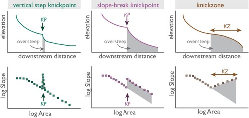
Knickpoints are steepened reaches of river, ranging from kilometre-scale slope breaks to discrete, stepwise vertical breaks in slope, i.e. waterfalls (DiBiase et al., Citation2010; Goldrick & Bishop, Citation2007; Haviv et al., Citation2010). In some cases, successive accumulation of knickpoints develop wide convex regions termed ‘knickzones’ (e.g. Castillo et al., Citation2013; Jansen et al., Citation2010). These types of steepened zones reflect localized river channel incision as the river adjusts to new conditions reset by the perturbation. Migration of the knickpoint results in a new erosional capacity that is translated upstream through the river network over time, thereby setting how fast adjacent hillslopes erode and how quickly sediments are transferred downstream to the ocean.
Controls on knickpoint formation in Scottish rivers
Bishop was well-versed in the evolution of bedrock rivers and knickpoints before his arrival in Scotland to join the University of Glasgow in 1998. His work in eastern Australia set standards for the long profile analysis of river geomorphology (Bishop et al., Citation1985; Bishop & Brown, Citation1992; Goldrick & Bishop, Citation1995; van der Beek & Bishop, Citation2003) and created a foundation from which to write his next research chapter on bedrock rivers in Scotland. Upon viewing steep bedrock streams carving through the abandoned coastal and marine terraces at 30–25 m above modern mean sea-level in eastern Scotland, Bishop quickly recognized there were knickpoints to investigate.
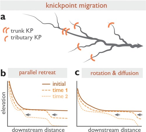
In a study of 15 coastal bedrock rivers (catchment size: 1–128 km2) steeply cutting through raised shorelines, Bishop et al. (Citation2005) identified a series of knickpoints and their distributions upstream. These uplifted shorelines and associated glacial outwash terraces upstream were widely agreed to have formed at 14–12.5 ka, after the Last Glacial Maximum (∼29 ka) during a period where rates of glacial isostatic rebound and eustatic sea level rise were similar, and subsequently elevated by continued glacial isostatic rebound and relative sea-level fall (Cullingford & Smith, Citation1980; Smith et al., Citation2000). Utilizing field work and analyzing river profiles using Ordnance Survey (OS) topographic maps, Bishop et al. (Citation2005) highlighted that catchment discharge (or its surrogate, catchment drainage area) provided first-order control on the distance that any knickpoint propagated upstream ().
Figure 2. Knickpoint migration and evolution. (A) Example of knickpoint migration in map view, where rate of upstream knickpoint propagation is correlated to A, the upstream drainage area (where area ≈ discharge). Long profile views of knickpoint migration and evolution over time, following classical stream-power-law predictions: (B) maintenance of knickpoint form by parallel retreat and (C) knickpoint retreat with rotation and diffusion of knickpoint form (Howard et al., Citation1994; Whipple & Tucker, Citation1999). Modified from Bishop et al. (Citation2005); Castillo et al. (Citation2013); Howard et al. (Citation1994).
A later study of 14 small coastal streams on Jura explored similar propagating knickpoints initiated by deglacial and post-glacial base-level fall (Castillo et al., Citation2013). Again, close correlation between distance of knickpoint propagation and catchment area emphasized strong control of river discharge on knickpoint recession rates, with much lesser control by lithology and structure on knickpoint recession and overall river profile morphology. Yet small catchments (<4 km2) on Jura hosted convex river-long profiles rather than concave profiles. The small catchment area fundamentally limits the available stream power, suggesting that knickpoints are unable to continue to propagate fully upstream as contributing catchment area declines (i.e. Crosby & Whipple, Citation2006; Whipple & Tucker, Citation1999).
Exploration of rivers (10–820 km2) draining to Loch Linnhe demonstrated strong control by lithology on knickpoint recession and morphology (Jansen et al., Citation2010). Knickpoints that developed in resistant rocks such as quartzite were suggested to absorb part to all of propagating signals (i.e. knickpoints) moving upstream. Quartzite ‘barriers’ found to be closer to the river mouth (<2 km) required pronounced increases in total stream power, suggesting that by stalling signals of ongoing base-level fall, strong bedrock barriers could ‘amplify’ knickpoints over time, while also buffering the upstream catchment from exhibiting an erosional response. By conducting cosmogenic radionuclide dating on uplifted terraces associated with propagating knickpoints, Jansen et al. (Citation2011) concluded that knickpoints triggered by deglacial base-level fall were quickly established and rapidly propagated upstream in the immediate aftermath of deglaciation. This rapid knickpoint migration was facilitated by provision of ample sediment ‘tools’ shortly after deglaciation, when there was a ready supply of paraglacial sediment to facilitate accelerated fluvial erosion and incision (Korup & Schlunegger, Citation2007; Schaller et al., Citation2005; Valla et al., Citation2010). Subsequent depletion of ‘tools’ then limited incision (Church & Ryder, Citation1972; Sklar & Dietrich, Citation2001), such that rates of knickpoint retreat slowed down (Jansen et al., Citation2011).
On the siting of watermills
Watermills today can evoke feelings of the idyllic and pastoral (think, for example, of John Constable’s The Hay Wain (Citation1821)Footnote2, consistently voted as one of the British public’s favorite paintings) and yet watermills also gave rise to industry and the factories of the Industrial Revolution. For over two millennia, water from rivers provided mechanical power by way of mills equipped with waterwheels (Curwen, Citation1944; Lucas, Citation2006; Reynolds, Citation1983, Citation2006; Stowers, Citation1955; Wikander, Citation2000). Watermills were used for a wide range of industrial activities: the grinding of cereal grains, the sawing of timber, weaving of cloth, processing of metals and gunpowder, and the powering of bellows for blast furnaces (Lucas, Citation2005; Reynolds, Citation1983). The processing of materials for footwear, clothing, food, accommodation, and tools were all inextricably linked to milling, such that watermills have been familiar features along British waterways for a significant portion of human history (i.e. Curwen, Citation1944; Hodgen, Citation1939; Holt, Citation1988; Langdon, Citation2004; Wilson, Citation2002). In essence, ‘[w]ater mills were the most powerful, costly and elaborate machines employed by pre-modern societies in peacetime’ (Hammer, Citation2008, p. 320).
Identifying a suitable site for a watermill therefore merited ample consideration by any millwright. Power needs, water availability and regularity, existing infrastructure and topography all contributed to mill site selection. If water supply was generally sufficient, site selection depended on the technology employed (i.e. type of waterwheel) and the topography of the mill site. Watermills convert energy from flowing water by directed introduction of water to radial blades (vanes, paddles) or buckets on a mill wheel. Waterwheel types are defined by the overall orientation of the wheel, where water is introduced to the wheel relative to the wheel axle, and the wheel’s direction of turn ().
Figure 3. (A – D) Types of vertical waterwheel, modified after Shaw (Citation1984). All wheels, except the overshot wheel (C), rotate anticlockwise. In the overshot (C) and pitchback (D) wheels, a launder delivers water to top of the wheel.
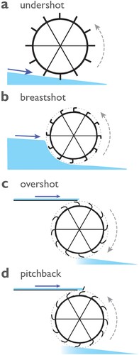
Horizontal-wheeled watermills have vertical axes of rotation and vertical-wheeled watermills rotate around a horizontal axle. Among vertical waterwheels, an undershot wheel is one where a jet of water is delivered by a channel (or lade) below the horizon of the axle to the bottom of the wheel. Breastshot and overshot wheels require water delivered part-way up or above the axle and to the top of the wheel, respectively. Pitchback wheels, a type of overshot wheel, utilize the same top-of-wheel water delivery but rotate in the opposite direction.
Undershot wheels are impulse-driven wheels, where wheel rotation is driven by the velocity of the water striking the blades. Overshot wheels, equipped with buckets rather than vanes or paddles, utilize the weight of the water filling the buckets consecutively to drive wheel rotation. Fast-flowing streams with minimal change in elevation between water entry to the wheel and water exit from the wheel (overall, termed head or fall) are ideal for undershot wheels. Overshot wheels make best use of higher head and slower velocities to fill buckets. Breastshot wheels allow the most flexibility; their intermediate design accommodates sites with moderate head and, perhaps most crucially, variability in flow.
Until the mid-eighteenth century, virtually none of the wheels were designed according to scientific principles and subsequently suffered from low efficiencies in converting energy from running water to mechanical energy (c.f., Capecchi, Citation2013; Müller & Kauppert, Citation2004; Smeaton, Citation1759). Nonetheless, overshot wheel designs offered the most power potential of any type of vertical-wheeled mill. The utilization of the gravitational potential energy of water (combined weight of water and height difference via the head) meant that this wheel type could reach energy efficiencies of up to 70–80%. Undershot wheels were the least efficient. By taking advantage of only the comparatively meagre kinetic energy of flowing water slapping the paddles, efficiencies were usually no greater than 40% (e.g. Kanefsky, Citation1979; Reynolds, Citation1983).
Water was delivered to the wheel through a channel or trough. Many different names – including lade, lead, leat, launder, head race, mill race, goit – refer to these channels (see Bishop, Citation2021; Oliver, Citation2013). Similarly, the channel directing water away from the bottom of the wheel is commonly termed the ‘tail race’. Undershot wheels were generally cheaper and easier to build and maintain. Minimal infrastructure was needed to direct water at sufficient velocity to the bottom of the waterwheel. The nature of overshot wheels, however, required more extensive infrastructure to ensure water was delivered to the top of the wheel and at an optimum velocity. Commonly the elevation of the water level was achieved by building a reservoir or millpond upstream of the mill and maintaining as much as possible of the elevated water height along the mill lade before delivery directly to the water wheel. Alternatively, if the mill was located on a steep stream or not far downstream from a step in the river profile (knickpoint), a mill could exploit the channel gradient and operate on ‘run of the river’ flow ().
Figure 4. Schematic diagrams of river long profile, mill dam, lade and wheel for a (A) low gradient stream and (B) a stream with a knickpoint. Note that the lower gradient stream requires a larger dam and a longer lade to deliver the water to the top of the waterwheel. Modified from Bishop and Muñoz-Salinas (Citation2013).
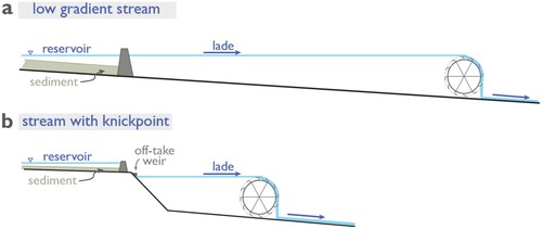
A low weir (or ‘caul’ in Scots), either partly or fully built across a river, could divert water from the river to the lade which then shortly delivered elevated water to the wheel. By exploiting steep rivers with abrupt changes in gradient, the cost of a mill constructed on a knickpoint rather than a lowland mill was less, because no large dams, high dam walls, or long lades were required (Bishop & Muñoz-Salinas, Citation2013).
British watermills as hazards?
By attenuating river flow and influencing the cascade of sediment delivered downstream, artificial dams and barriers influence river connectivity and therefore their long-term stability and morphology (Wohl et al., Citation2017). Sediments build up behind dams and are scoured from their base. From the medieval period and throughout the early modern period and Industrial Revolution, the total number and density of watermills increased on many English and Scottish rivers (Bishop & Muñoz-Salinas, Citation2013; Reynolds, Citation1983; Shaw, Citation1984; Wilson, Citation2002). With the increasing use of waterpower, mill impoundments and river modification also increased; with the demise of traditional waterpower towards the end of the nineteenth century, many watermills closed and their structures fell into disrepair (Reynolds, Citation2006). Obsolete mill dams were no longer dredged and dam walls were not repaired. It is those remnant impoundment structures that Downward and Skinner (Citation2005) constituted a hazard worthy of consideration in their work on England’s ‘working rivers’.
Downward and Skinner (Citation2005) investigated three English rivers in varying states of industrial dereliction. All had documented milling since at least Domesday (1086 CE) and in all cases rivers were clearly altered by historical lades, weirs, and/or dams. While two of the cases indicated management or maintenance of the artificial state of the river, the third was entirely unmanaged. After failure of at least one old mill structure and the creation of an alluvial knickpoint in 2002, the river began to self-regulate. The knickpoint rapidly migrated upstream and induced riverbank destabilization and a pulse of sediment moving downstream. Although this example was relatively harmless to property and life, it served as a cautionary tale. Given that the natural state of British rivers pre-dates most detailed documentary records and even in their altered state rivers are unpredictable, Downward and Skinner (Citation2005) recommended rapid risk assessment of ‘working rivers’ in Britain.
Bishop and Jansen (Citation2005), building from their work in E and NW Scotland, commented on the work of Downward and Skinner (Citation2005) and the implications for Scotland. Firstly, Bishop and Jansen (Citation2005) pointed out that not all mills required elaborate infrastructure (i.e. dams) if topography allowed. It is here that Bishop first published his observations that (i) many of the watermills in the lower reaches of Scottish rivers are found downstream of bedrock knickpoints and (ii) as such, this allowed these watermills to be operated on a ‘run-of-the-river’ arrangement that required minimal damming, if any. The overly steepened lower reaches provided excellent mill sites for growing communities along the coasts. Dams, if required, were much smaller and trapped significantly less sediment than either their English or eastern US counterparts (c.f., Bishop et al., Citation2010; Downward & Skinner, Citation2005; Pizzuto & O'Neal, Citation2009; Walter & Merritts, Citation2008).
Secondly, bedrock rivers were less likely to generate the hazards envisaged by Downward and Skinner (Citation2005). While Scottish bedrock knickpoints are geologically transient features, some are effectively stalled in place over geological timescales (>104 yr; Jansen et al., Citation2010). While there are those that may be able to propagate freely and rapidly upstream over shorter timescales (103–104 yr; Bishop et al., Citation2005; Castillo et al., Citation2013), their rates of propagation can be incremental such that retreat may only occur under very particular conditions (Jansen et al., Citation2011). In both scenarios, bedrock knickpoints are stable over human timescales (<103 yr), if not far longer. The fluvial dynamics of bedrock rivers versus alluvial rivers, and the construction of infrastructure upon them, was an essential difference.
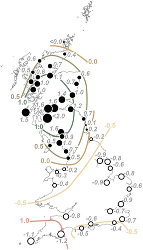
The last and perhaps pivotal point is the differential Quaternary history giving rise to river shape. The British–Irish Ice Sheet covered much of Britain during the Quaternary period (Clark et al., Citation2004; Evans et al., Citation2005). Regions covered by the ice sheet were depressed downward by the load of the ice. After deglaciation, unloading of the ice in northern Britain allowed Earth’s crust to rebound and rise relative to sea-levels (; Lambeck, Citation1995; Shennan & Horton, Citation2002; Stockamp et al., Citation2015). Conversely, unglaciated southern Britain was flexed downward following deglaciation. To compensate for unloading of the crust in the north, the rigidity of Earth’s crust induced subsidence in the south – producing a lever-arm or see-saw effect between an uplifting north and subsiding south (Lambeck, Citation1995). Subsidence and thick postglacial sedimentation characterize many English alluvial rivers (e.g. Downward & Skinner, Citation2005), whereas rebound and bedrock incision by rivers is noted in the north (Bishop et al., Citation2005; Castillo et al., Citation2013; Jansen et al., Citation2010; Jansen et al., Citation2011).
Figure 5. Relative land-/sea-level changes (mm yr−1) since 4000 cal yr BP. Positive values indicate relative land uplift and sea-level fall (Scotland) and relative land subsidence and sea-level rise (southern England). Modified from Shennan and Horton (Citation2002). Contours are drawn after data.
Bringing together fluvial geomorphology and watermills
The realization that watermill sites were often coincident with knickpoints, combined with an understanding of the differential uplift history of Britain, inspired the integration of three of Bishop’s passions: history, geomorphology, and cartography. Bishop and Muñoz-Salinas (Citation2013) combined digital topographic data and mill locations gathered from the National Library of Scotland (NLS) GB1900 Gazetteer in the first of a series of studies aiming to identify where mills were placed on drainage networks. Analysis of the GB1900 Gazetteer, a crowdsourced project transcribing 2.2 million place names from the 2nd edition OS six-inch to the mile maps of England, Scotland, and Wales (1888–1914), revealed 1682 ‘mill’, ‘milton’, and ‘mill’ locations. Two study locations in NE Scotland and SE England were chosen for further geomorphological analysis. From a dataset of approximately half of all GB1900 mill locations, Bishop and Muñoz-Salinas (Citation2013) identified that almost all mills in both study locations were sited within 10 km of river channel heads (∼2.5 km2 threshold drainage area) and on steep, moderately-sized rivers. North-eastern Scottish mills were sited along steeper rivers, and as such, combined with the greater overall precipitation and runoff in Scotland, likely required smaller and/or fewer mill dams than English mills. This suggested that Scottish mill dams were likely to have lower sediment trapping efficiencies, lending support to earlier work that argued Scottish mill dams constituted less of a hazard than their English counterparts (Bishop & Jansen, Citation2005).
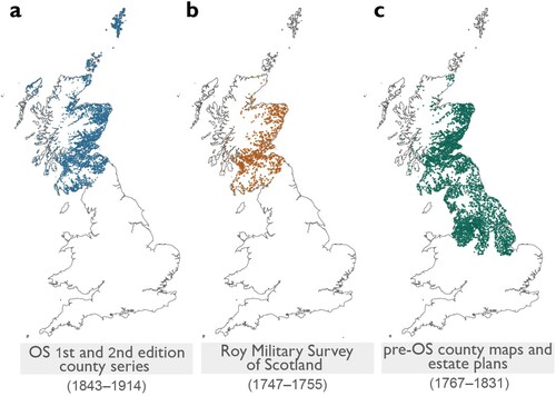
The Scottish Water Mills Project followed this work. Iara Nave Calton, a University of Glasgow PhD student co-supervised by Bishop, developed and published the interactive ‘Scottish water mills’ database hosted by the National Library of Scotland (NLS) and jointly funded by the Arts and Humanities Research Council.Footnote3 Through her work with the NLS (A), she extended the cartographic database of Scottish mills beyond the GB1900 Gazetteer to include the 1st edition OS six-inch to the mile (1843–1882) and 2nd edition OS 25-inch to the mile (1892–1914) county series maps.
Figure 6. Over 20,000 observations of mills in Scotland and northern England from historic maps held by the National Library of Scotland digital archive. (A) Mill locations from Ordnance Survey (OS) 1st and 2nd edition county series maps of Scotland (1843–1914) and HES database as part of the Scottish Water Mills Project; (B) Mill locations queried from the Roy Gazetteer of the Roy Miliary Survey of Scotland (1747–1755); and (C) Mill locations from pre-OS county maps and estate plans (1767–1831) for Scotland and select counties of northern England. Mapping in (B) and (C) is ongoing and part of the ‘Away from the Water’ project (T. Jonell, pers. comm.).
Calton further collated mill records with Historic Environment Scotland’s National Record of the Historic Environment (‘Canmore’) database. To-date, this is arguably the most detailed cartographic record of historic mills for the UK, featuring more than 9,795 georeferenced and classified mills, mill dams, and lades. Her work set a precedent for GIS mapping of all British pre-OS watermills, which is being pursued in an ongoing research project, awarded to Bishop and Adam Lucas (University of Wollongong). This project is discussed in more depth below.
From watermills in Milngavie to beyond
Alongside the Scottish Water Mills Project, Bishop explored Scottish milling and cartography through a series of short papers, often using his backyard to ground-truth concepts (Bishop, Citation2011a, Citation2011b, Citation2017, Citation2019, Citation2021, Citation2022; Bishop & James, Citation2019; James & Bishop, Citation2018). Baldernock Mill near Milngavie, whose watermill site was occupied from at least 1532, served as a centrepiece for Bishop. He explored multiple generations of waterwheels based on power needs (Bishop, Citation2019), dam failure (Bishop et al., Citation2010), early nineteenth century Scottish lint (flax) milling by way of two archaeological surveys funded by the Society of Antiquaries Scotland (Bishop & James, Citation2019; James & Bishop, Citation2018), and collapse of the corn milling industry following repeal of the Corn Laws in 1815 (Bishop, Citation2011a). Exploration involved assessing the accuracy of archival sources, including the New Statistical Account and the OS Books of Reference (Bishop, Citation2017) and how mills and their infrastructure were depicted in OS maps (Bishop, Citation2021, Citation2022). Bishop noted the power of OS maps to inform on regional water milling technology and on ‘the ways which the Scottish situation exploited Scotland’s particular river geomorphology and hydrology’ (Bishop, Citation2021, p. 34).
Bishop’s background in the history and topography of milling lent itself naturally to investigation of other inland waterways – canals and reservoirs. If the waterwheel was the ‘heart’ of the early Industrial Revolution, canals were its arteries. Like watermills, canals conveyed water, but for controlled, fast and efficient means of cross-country transport rather than sustained power. And, like watermills early canals were vulnerable to water shortages (Bishop, Citation2020; Harvey-Fishenden et al., Citation2019). Leakage and overflow were continual problems in early canals and maintaining a constant level of water was difficult. Canal infrastructure, although similar to that of mills, was of an entirely different magnitude. Rather than one or two mill ponds upstream, a canal required an interconnected network of reservoirs across the landscape, which guaranteed water inflow to the canal from uplands to the sea. The largest water reservoirs in Britain were not built for industrial or domestic use but for canals (Brown, Citation2009; Harvey-Fishenden & Macdonald, Citation2021; Lindsay, Citation1968).
Stretching ∼53 km from Glasgow to Edinburgh, the Forth and Clyde Canal drew on nine reservoirs along its length. The five current reservoirs that supply water for the canal have detailed records, yet much less was known about four smaller reservoirs that were also once part of the canal system. Bishop explored these four ‘forgotten’ reservoirs using archival research and fieldwork, including through the production of new hydrographic surveys as part of the THEN/NOW public art project (Bishop, Citation2020; Donald et al., Citation2020).Footnote4 He elucidated the complex network of engineering required for maintaining water supply not only to the Forth and Clyde Canal but the ‘extensive hidden infrastructure distinct from but connected to the canal’ (Bishop, Citation2020, p. 141) essential to the local milling industry.
Scottish and southern Italian horizontal mills
Bishop's interest in rivers, history, and milling was not confined to Scotland: it flowed naturally across borders and extended far and wide. His novel approach and combination of methodologies permitted re-examination of prevailing narratives in earth science, history, or both. In many histories of watermills, horizontal waterwheels are given short shrift despite a rich history (see Lucas, Citation2006; Squatriti, Citation2002). Examples from the British Isles are often cursorily treated (Gauldie, Citation1981; Shaw, Citation1984), assumed to be less sophisticated than vertical wheels, or simply described as ‘primitive’ (Reynolds, Citation1983, p. 14). In a collaboration led by Maria Carmela Grano, Bishop explored horizontal waterwheel application as a ‘stand-alone technology that operated alongside and parallel to the vertical waterwheel’ (Barceló, Citation2004) and as a technology best suited to the needs of a miller given the resources at hand (Grano et al., Citation2016; Grano & Bishop, Citation2017). Combining the natural laboratory of the Basilicata landscape and the historical survey of mills via the 1895 Carta Idrografica del Regno d’Italia (Hydrographic Map of the Italian Kingdom), Grano et al. (Citation2016) analyzed over 800 Arubah or “drop-tower” style horizontal-wheeled mills through fieldwork and GIS geomorphological analysis. They found that horizontal mills were finely engineered to the steep gradients and fast-flowing streams of the mountainous Basilicata; with mill lades clearly built to suit stream gradient and water towers designed to take optimal advantage of knickpoints and fall. With the use of this technology, horizontal wheels were preferentially built on and harnessed energy from fifth and sixth order streams flowing at elevations of 300–1000 meters. Unlike certain types of vertical waterwheels, the Basilicata horizontal-wheeled mills could accommodate wide variability in stream flow, occurring in both dry summers and springtime floods (e.g. Grano et al., Citation2016). The supposedly primitive horizontal-wheeled mill was anything but. Rather, it was a carefully engineered technology in tune with demand and the natural resources at hand (Grano & Bishop, Citation2017).
Watermills and the industrial revolution: ‘Away from the water’
In 2021, Bishop and Lucas commenced the project ‘‘Away from the Water’: the first energy transition, British textiles 1770–1890’ funded by the Leverhulme Trust. They first began a collaborative project in 2016 initially exploring the micro-hydropower potential of the United Kingdom by combining geomorphological research with mapping of extant historical mill infrastructure. Further intrigued by some of the arguments put forth in Andreas Malm’s Fossil Capital: The Rise of Steam Power and the Roots of Global Warming (2016), they instead set out to design an alternative research project to empirically test some of the key problems and hypotheses outlined by Malm. The question of how much waterpower was available and remained unused during the British Industrial Revolution was a key focus for Malm (Citation2016); his research underscored that conventional narratives for the ‘end of the Age of Water Power’ in late eighteenth and nineteenth Scotland and England required a transdisciplinary lens to unpack the dynamic forces driving the shift away from waterpower to coal-based steam power during the Industrial Revolution (c.f., Baines, Citation1835; Chapman, Citation1971; Crafts & Wolf, Citation2014; Gordon, Citation1983; Jones et al., Citation2023; Kane, Citation1845; Kelly et al., Citation2023; Pomeranz, Citation2000; Shaw, Citation1984; Von Tunzelmann, Citation1978; Wilkinson, Citation1973; Wrigley, Citation1988). The Leverhulme project that evolved from those discussions draws from the fields of economic history, the history of technology, and geomorphology. Its five-member team (2021–2024)Footnote5 employs a range of methodologies: archival inquiry; secondary literature surveys; site-specific case studies; field work; quantitative geomorphology; and hydrological analysis. To analyze the geomorphological settings and distribution of watermills in Scotland and northern England, an extended mill census covering the pre-OS period (c. 1760–1840) is being integrated with findings from the Scottish Water Mills Project. Pre-OS historical maps, including the 1747–1755 Roy Military Survey of Scotland (NLS Roy Gazetteer)Footnote6, and georeferenced 18–19th county and estate maps are being targeted for the pre-OS mill census ((B,C)). The mill datasets, when combined with historical datasets for rainfall, river, and reservoir gauging, will serve as a powerful physical complement to social, economic, and technological narratives for the Industrial Revolution. To-date, the project has compiled a large amount of geomorphologic, cartographic, and documentary evidence to complement past scholarly work that emphasizes the persistence of waterpower and its contributions to the British Industrial Revolution.
Conclusion
Paul Bishop’s extensive exploration of rivers and landscapes, from Australia to Scotland, was driven by his insatiable curiosity and huge knowledge of geological and historical topics. Inspired by the knickpoint and mill in his own backyard, Bishop examined the long-lasting legacy effects of physical geography on human history: ancient rivers eroded into their bedrock and modified post-glacial landscapes, creating ideal locations for water-powered mills and local industries to later flourish. Bishop’s approach broke down disciplinary barriers between geomorphology, geography, and history to encourage a more holistic investigation of the complex and dynamic interactions between natural and human systems over the last 250 years. His research unearthed pivotal connections between river knickpoints and watermills, which permitted him to challenge prevailing misconceptions about water technology and patterns of water-powered industrialization in Britain. Bishop’s work was wide-ranging in its breadth but simple in its approach, serving as a strong foundation from which to build. Paul Bishop, like the rivers and landscapes he explored, carved a legacy to follow.
Acknowledgements
As a friend, mentor, and colleague, PB was warm, generous, incisive, and always overflowing with enthusiasm. He is sorely missed. We thank Editor Chris Philo for the invitation to contribute to this special issue. All authors also thank Chris Fleet of the NLS Map Library for his continuing support and help.
Disclosure statement
No potential conflict of interest was reported by the author(s).
Data availability statement
Historical mill data from 1843–1914 mentioned in this work are available through the National Library of Scotland ‘Scottish Water Mills Project’ website (https://maps.nls.uk/projects/mills/index.html). Data from 1747–1831 are derived from maps held in the public domain: through the collaborative Roy Gazetteer project between the National Library of Scotland and British Library (https://maps.nls.uk/roy/) and from county maps held by the National Library of Scotland (https://maps.nls.uk/counties/), the Digital Archive at McMaster University Library (http://digitalarchive.mcmaster.ca/), and the Yale University Library (https://library.yale.edu/). Data associated with the ‘Away from the Water’ project are available upon request from the corresponding author.
Additional information
Funding
Notes
1 The colours of the Baldernock tartan, registered March 2020, are inspired by those on William Roy’s Military Survey of Scotland (1747–1755) maps; https://www.baldernock.org.uk/tartan
3 Read more on the ‘Scottish Water Mills Project’, including the methodology at https://maps.nls.uk/projects/mills/
4 Read more on THEN/NOW at http://www.then-now.org/
5 More information about the project can be found here: https://www.gla.ac.uk/research/az/awayfromthewater/
6 In 2022, over 180 volunteers transcribed >30,000 names from the Roy Military Survey of Scotland to form the Roy Gazetteer database. See https://maps.nls.uk/roy/gazetteer/ for further details.
References
- Baines, E. (1835). History of the cotton manufacture in Great Britain. Cambridge University Press.
- Barceló, M. (2004). The missing water–mill: A question of technological diffusion in the High Middle Ages. In M. Barceló & F. Sigaut (Eds.), The making of feudal agricultures? (pp. 255–314). Brill. https://doi.org/10.1163/9789047404033_008
- Bishop, P. (2011a). The water mills of baldernock parish. History Scotland, 39–43.
- Bishop, P. (2011b). Whin millstones in Baldernock, western Central Belt. Vernacular Building, 34, 43–54.
- Bishop, P. (2017). Useful local history sources 4: Ordnance Survey Books of Reference. Scottish Local History, 96, 39–43.
- Bishop, P. (2019). A rural water mill in Baldernock, East Dunbartonshire. Vernacular Building, 42, 77–96.
- Bishop, P. (2020). Reservoirs for the Forth and Clyde canal. In M. Donald (Ed.), THEN/NOW (pp. 139–158). British Library Cataloguing in Publication Data.
- Bishop, P. (2021). OS mapping of water mills. Sheetlines, 120.
- Bishop, P. (2022). OS 25-inch mapping of threshing mills in Scotland. Sheetlines, 123, 7–25. https://s3.eu-west-2.amazonaws.com/sheetlines-articles/Issue123page7.pdf
- Bishop, P., & Brown, R. (1992). Denudational isostatic rebound of intraplate highlands: the Lachlan River valley, Australia. Earth Surface Processes and Landforms, 17(4), 345–360. https://doi.org/10.1002/esp.3290170405
- Bishop, P., Hoey, T. B., Jansen, J. D., & Artza, I. L. (2005). Knickpoint recession rate and catchment area: the case of uplifted rivers in Eastern Scotland. Earth Surface Processes and Landforms, 30(6), 767–778. https://doi.org/10.1002/esp.1191
- Bishop, P., & James, H. (2019). Baldernock Lint Mill. C. C. Ltd.
- Bishop, P., & Jansen, J. D. (2005). The geomorphological setting of some of Scotland’s east coast freshwater mills: a comment on Downward and Skinner (2005) ‘Working rivers: the geomorphological legacy … ’. Area, 37(4), 443–445. https://doi.org/10.1111/j.1475-4762.2005.00642.x
- Bishop, P., & Muñoz-Salinas, E. (2013). Tectonics, geomorphology and water mill location in Scotland, and the potential impacts of mill dam failure. Applied Geography, 42, 195–205. https://doi.org/10.1016/j.apgeog.2013.04.010
- Bishop, P., Muñoz-Salinas, E., MacKenzie, A. B., Pulford, I., & McKibbin, J. (2010). The character, volume and implications of sediment impounded in mill dams in Scotland: the case of the Baldernock Mill dam in East Dunbartonshire. Earth and Environmental Science Transactions of the Royal Society of Edinburgh, 101(2), 97–110. https://doi.org/10.1017/S1755691010009205
- Bishop, P., Young, R., & McDougall, I. (1985). Stream profile change and longterm landscape evolution: Early Miocene and modern rivers of the east Australian highland crest, central New South Wales, Australia. The Journal of Geology, 93(4), 455–474. https://doi.org/10.1086/628966
- Brown, D. H. (2009). Scottish canal reservoirs–a historical perspective. Part 1: Lowlands. Dams and Reservoirs, 19(3), https://doi.org/10.1680/dare.2009
- Butlin, R. A. (1982). The transformation of rural England, c. 1580-1800: a study in historical geography. Oxford University Press.
- Capecchi, D. (2013). Over and undershot waterwheels in the 18th century. Science-technology controversy. Advances in Historical Studies, 02(03), 131–139. https://doi.org/10.4236/ahs.2013.23017
- Castillo, M., Bishop, P., & Jansen, J. D. (2013). Knickpoint retreat and transient bedrock channel morphology triggered by base-level fall in small bedrock river catchments: The case of the Isle of Jura, Scotland. Geomorphology, 180-181, 1–9. https://doi.org/10.1016/j.geomorph.2012.08.023
- Chapman, S. D. (1971). The cost of power in the industrial revolution in Britain: The case of the textile industry. Midland History, 1(2), 1–24. https://doi.org/10.1179/mdh.1971.1.2.1
- Church, M., & Ryder, J. M. (1972). Paraglacial sedimentation: a consideration of fluvial processes conditioned by glaciation. Geological Society of America Bulletin, 180-181(10), 3059–3072. https://doi.org/10.1130/0016-7606(1972)83[3059:PSACOF]2.0.CO;2
- Clark, C. D., Evans, D. J., Khatwa, A., Bradwell, T., Jordan, C. J., Marsh, S. H., Mitchell, W. A., & Bateman, M. D. (2004). Map and GIS database of glacial landforms and features related to the last British Ice Sheet. Boreas, 33(4), 359–375. https://doi.org/10.1080/03009480410001983
- Constable, J. (1821). The Hay Wain [oil on canvas]. The National Gallery.
- Crafts, N., & Wolf, N. (2014). The location of the UK cotton textiles industry in 1838: a quantitative analysis. The Journal of Economic History, 74(4), 1103–1139. https://doi.org/10.1017/S0022050714000874
- Crosby, B. T., & Whipple, K. X. (2006). Knickpoint initiation and distribution within fluvial networks: 236 waterfalls in the Waipaoa River, North Island, New Zealand. Geomorphology, 82(1-2), 16–38. https://doi.org/10.1016/j.geomorph.2005.08.023
- Cullingford, R. A., & Smith, D. E. (1980). Late devensian raised shorelines in angus and kincardineshire, Scotland. Boreas, 9(1), 21–38. https://doi.org/10.1111/j.1502-3885.1980.tb01022.x
- Curwen, E. C. (1944). The problem of early water-mills. Antiquity, 18(71), 130–146. https://doi.org/10.1017/S0003598X00018482
- DiBiase, R. A., Whipple, K. X., Heimsath, A. M., & Ouimet, W. B. (2010). Landscape form and millennial erosion rates in the San Gabriel Mountains, CA. Earth and Planetary Science Letters, 289(1-2), 134–144. https://doi.org/10.1016/j.epsl.2009.10.036
- Donald, M., Millar, N., & McGuire, N. (2020). THEN/NOW.
- Downward, S., & Skinner, K. (2005). Working rivers: the geomorphological legacy of English freshwater mills. Area, 37(2), 138–147. https://doi.org/10.1111/j.1475-4762.2005.00616.x
- Evans, D. J., Clark, C. D., & Mitchell, W. A. (2005). The last British ice sheet: A review of the evidence utilised in the compilation of the glacial Map of Britain. Earth-Science Reviews, 70(3-4), 253–312. https://doi.org/10.1016/j.earscirev.2005.01.001
- Flint, J.-J. (1974). Stream gradient as a function of order, magnitude, and discharge. Water Resources Research, 10(5), 969–973. https://doi.org/10.1029/WR010i005p00969
- Gauldie, E. (1981). The Scottish Country Miller 1700-1900: A history of water-powered meal milling in Scotland. John Donald Publishers Ltd.
- Goldrick, G., & Bishop, P. (1995). Differentiating the roles of lithology and uplift in the steepening of bedrock river long profiles: an example from southeastern Australia. The Journal of Geology, 103(2), 227–231. https://doi.org/10.1086/629738
- Goldrick, G., & Bishop, P. (2007). Regional analysis of bedrock stream long profiles: evaluation of Hack's SL form, and formulation and assessment of an alternative (the DS form). Earth Surface Processes and Landforms, 32(5), 649–671. https://doi.org/10.1002/esp.1413
- Gordon, R. B. (1983). Cost and use of water power during industrialization in New England and Great Britain: a geological interpretation. The Economic History Review, 36(2), 240–259. https://doi.org/10.2307/2595922
- Grano, M. C., & Bishop, P. (2017). Barceló's ‘Missing Water Mills’ and Scottish and southern Italian horizontal mills. Vernacular Building, 40, 109–122.
- Grano, M. C., Del Monte, M., Lazzari, M., & Bishop, P. (2016). Fluvial dynamics and watermill location in Basilicata (southern Italy). Geografia Fisica e Dinamica Quaternaria, 39, 149–160. https://doi.org/10.4461/GFDQ2016.39.14
- Gregory, D. (1982). Regional transformation and industrial revolution: a geography of the Yorkshire woollen industry. Springer.
- Hack, J. T. (1957). Studies of longitudinal stream profiles in Virginia and Maryland (Vol. 294). US Government Printing Office.
- http://www.jstor.org/stable/20742566, C. I. (2008). “A suitable place for putting up a mill.” Water power landscapes and structures in Carolingian Bavaria. VSWG: Vierteljahrschrift Für Sozial- Und Wirtschaftsgeschichte, 95(3), 319–334. http://www.jstor.org/stable/20742566
- Harvey-Fishenden, A., & Macdonald, N. (2021). The development of early reservoirs to supply water to arterial canals in England and Wales. Landscape History, 42(2), 79–98. https://doi.org/10.1080/01433768.2021.1999016
- Harvey-Fishenden, A., Macdonald, N., & Bowen, J. P. (2019). Dry weather fears of Britain’s early ‘industrial’ canal network. Regional Environmental Change, 19(8), 2325–2337. https://doi.org/10.1007/s10113-019-01524-5
- Haviv, I., Enzel, Y., Whipple, K., Zilberman, E., Matmon, A., Stone, J., & Fifield, K. (2010). Evolution of vertical knickpoints (waterfalls) with resistant caprock: Insights from numerical modeling. Journal of Geophysical Research: Earth Surface, 115, F03028. https://doi.org/10.1029/2008JF001187
- Hodgen, M. T. (1939). Domesday water mills. Antiquity, 13(51), 261–279. https://doi.org/10.1017/S0003598X00014514
- Holt, R. (1988). The mills of medieval England. Wiley-Blackwell.
- Howard, A. D., Dietrich, W. E., & Seidl, M. A. (1994). Modeling fluvial erosion on regional to continental scales. Journal of Geophysical Research: Solid Earth, 99(B7), 13971–13986. https://doi.org/10.1029/94JB00744
- James, H., & Bishop, P. (2018). Baldernock mill. C. C. Ltd.
- Jansen, J. D., Codilean, A. T., Bishop, P., & Hoey, T. B. (2010). Scale dependence of lithological control on topography: Bedrock channel geometry and catchment morphometry in western Scotland. The Journal of Geology, 118(3), 223–246. https://doi.org/10.1086/651273
- Jansen, J. D., Fabel, D., Bishop, P., Xu, S., Schnabel, C., & Codilean, A. T. (2011). Does decreasing paraglacial sediment supply slow knickpoint retreat? Geology, 39(6), 543–546. https://doi.org/10.1130/G32018.1
- Jones, P., Jonell, T. N., Hurst, M. D., Lucas, A. R., & Naylor, S. (2023). Location, location, location: reassessing W.H.K. Turner’s legacy for industrial geography in Scotland and beyond. Scottish Geographical Journal, 1–14. https://doi.org/10.1080/14702541.2023.2178666
- Kane, R. (1845). The industrial resources of Ireland (No. 34074). Hodges and Smith.
- Kanefsky, J. W. (1979). The diffusion of power technology in British Industry, 1760-1870. University of Exeter, unpub. PhD thesis.
- Kelly, M., Mokyr, J., & Ó Gráda, C. (2023). The mechanics of the industrial revolution. Journal of Political Economy, 131(1), 59–94. https://doi.org/10.1086/720890
- Korup, O., & Schlunegger, F. (2007). Bedrock landsliding, river incision, and transience of geomorphic hillslope-channel coupling: Evidence from inner gorges in the Swiss Alps. Journal of Geophysical Research: Earth Surface, 112, F03027. https://doi.org/10.1029/2006JF000710
- Lambeck, K. (1995). Late Devensian and Holocene shorelines of the British Isles and North Sea from models of glacio-hydro-isostatic rebound. Journal of the Geological Society, 152(3), 437–448. https://doi.org/10.1144/gsjgs.152.3.0437
- Langdon, J. (2004). Mills in the medieval economy: England 1300-1540. OUP Oxford.
- Lindsay, J. O. (1968). The canals of Scotland (Vol. 8). AM Kelley.
- Lucas, A. (2006). Wind, water, work: ancient and medieval milling technology. Brill.
- Lucas, A. R. (2005). Industrial milling in the ancient and medieval worlds: A survey of the evidence for an industrial revolution in medieval Europe. Technology and Culture, 46(1), 1–30. https://doi.org/10.1353/tech.2005.0026
- Malm, A. (2016). Fossil capital: The rise of steam power and the roots of global warming. Verso.
- Müller, G., & Kauppert, K. (2004). Performance characteristics of water wheels. Journal of Hydraulic Research, 42(5), 451–460. https://doi.org/10.1080/00221686.2004.9641215
- Neely, A. B., Bookhagen, B., & Burbank, D. W. (2017). An automated knickzone selection algorithm (KZ-Picker) to analyze transient landscapes: Calibration and validation. Journal of Geophysical Research: Earth Surface, 122(6), 1236–1261. https://doi.org/10.1002/2017JF004250
- Ogden, H. W. (1927). 50—the geographical basis of the lancashire cotton industry. Journal of the Textile Institute Transactions, 18(11), T573–T594. https://doi.org/10.1080/19447022708661440
- Oliver, R. R. (2013). Ordnance Survey Maps: a concise guide for historians (3 ed.). Charles Close Society.
- Pizzuto, J., & O'Neal, M. (2009). Increased mid-twentieth century riverbank erosion rates related to the demise of mill dams, South River, Virginia. Geology, 37(1), 19–22. https://doi.org/10.1130/G25207A.1
- Pomeranz, K. (2000). The great divergence: Europe, China and the making of the modern world economy. Princeton University Press.
- Reynolds, T. S. (1983). Stronger than a hundred men: a history of the vertical water wheel. Johns Hopkins University Press.
- Reynolds, T. S. (2006). The phoenix and its demons: Waterpower in the past millennium. Transactions of the Newcomen Society, 76(2), 153–174. https://doi.org/10.1179/037201806X119787
- Roe, G. H., Montgomery, D. R., & Hallet, B. (2002). Effects of orographic precipitation variations on the concavity of steady-state river profiles. Geology, 30(2), 143–146. https://doi.org/10.1130/0091-7613(2002)030<0143:EOOPVO>2.0.CO;2
- Schaller, M., Hovius, N., Willett, S. D., Ivy-Ochs, S., Synal, H. A., & Chen, M. C. (2005). Fluvial bedrock incision in the active mountain belt of Taiwan from in situ-produced cosmogenic nuclides. Earth Surface Processes and Landforms, 30(8), 955–971. https://doi.org/10.1002/esp.1256
- Shaw, J. (1984). Water power in Scotland, 1550-1870. John Donald.
- Shennan, I., & Horton, B. (2002). Holocene land-and sea-level changes in Great Britain. Journal of Quaternary Science, 17(5-6), 511–526. https://doi.org/10.1002/jqs.710
- Sklar, L., & Dietrich, W. E. (1998). River longitudinal profiles and bedrock incision models: Stream power and the influence of sediment supply. Geophysical Monograph-American Geophysical Union, 107, 237–260.
- Sklar, L. S., & Dietrich, W. E. (2001). Sediment and rock strength controls on river incision into bedrock. Geology, 29(12), 1087–1090. https://doi.org/10.1130/0091-7613(2001)029<1087:SARSCO>2.0.CO;2
- Smeaton, J. (1759). XVIII. An experimental enquiry concerning the natural powers of water and wind to turn mills, and other machines, depending on a circular motion. Philosophical Transactions of the Royal Society of London, 51, 100–174.
- Smith, D. E., Cullingford, R. A., & Firth, C. R. (2000). Patterns of isostatic land uplift during the Holocene: evidence from mainland Scotland. The Holocene, 10(4), 489–501. https://doi.org/10.1191/095968300676735907
- Squatriti, P. (2002). Water and society in early medieval Italy, AD 400-1000. Cambridge University Press.
- Stockamp, J., Bishop, P., Li, Z., Petrie, E. J., Hansom, J., & Rennie, A. (2015). State-of-the-art in studies of glacial isostatic adjustment for the British Isles: a literature review. Earth and Environmental Science Transactions of the Royal Society of Edinburgh, 106(3), 145–170. https://doi.org/10.1017/S1755691016000074
- Stowers, A. (1955). Observations on the history of water power: Presidential address. Transactions of the Newcomen Society, 30(1), 239–256. https://doi.org/10.1179/tns.1955.016
- Turner, W. H. K. (1958). The significance of water power in industrial location: Some Perthshire examples. Scottish Geographical Magazine, 74(2), 98–115. https://doi.org/10.1080/00369225808735713
- Valla, P. G., van Der Beek, P. A., & Lague, D. (2010). Fluvial incision into bedrock: Insights from morphometric analysis and numerical modeling of gorges incising glacial hanging valleys (Western Alps, France). Journal of Geophysical Research: Earth Surface, 115, F02010. https://doi.org/10.1029/2008JF001079
- van der Beek, P., & Bishop, P. (2003). Cenozoic river profile development in the Upper Lachlan catchment (SE Australia) as a test of quantitative fluvial incision models. Journal of Geophysical Research: Solid Earth, 108(B6), 2309. https://doi.org/10.1029/2002JB002125
- Von Tunzelmann, G. N. (1978). Steam power and British industrialization to 1860. Clarendon Press.
- Walter, R. C., & Merritts, D. J. (2008). Natural streams and the legacy of water-powered mills. Science, 319(5861), 299–304. https://doi.org/10.1126/science.1151716
- Whipple, K. X. (2004). Bedrock rivers and the geomorphology of active orogens. Annual Review of Earth and Planetary Sciences, 32(1), 151–185. https://doi.org/10.1146/annurev.earth.32.101802.120356
- Whipple, K. X., & Tucker, G. E. (1999). Dynamics of the stream-power river incision model: Implications for height limits of mountain ranges, landscape response timescales, and research needs. Journal of Geophysical Research: Solid Earth, 104(B8), 17661–17674. https://doi.org/10.1029/1999JB900120
- Wikander, Ö. (2000). Handbook of ancient water technology. Brill.
- Wilkinson, R. (1973). Poverty and progress: An ecological model of economic development. Methuen.
- Wilson, A. (2002). Machines, power and the ancient economy. Journal of Roman Studies, 92, 1–32. https://doi.org/10.2307/3184857
- Wohl, E. E., & Merritt, D. M. (2001). Bedrock channel morphology. Geological Society of America Bulletin, 113(9), 1205–1212. https://doi.org/10.1130/0016-7606(2001)113<1205:BCM>2.0.CO;2
- Wohl, E., Magilligan, F. J., & Rathburn, S. L. (2017). Introduction to the special issue: Connectivity in Geomorphology (Vol. 277, pp. 1–5). Elsevier. https://doi.org/10.1016/j.geomorph.2016.11.005.
- Wrigley, E. A. (1988). Continuity, chance and change. Cambridge University Press.