
ABSTRACT
Radiocarbon ages for samples of organic material within and overlying the highest Holocene floodplain and fan terraces in Glen Feshie and Glen Tromie imply sediment aggradation after ∼4.3 cal ka and probably incision after ∼3.7 cal ka, and in the Edendon Valley aggradation after ∼2.8 cal ka, with incision after ∼2.7 cal ka. The timing of sediment aggradation at all three sites postdates the onset of pine forest decline (∼4.8 cal ka) at nearby high-level sites, and coincides with wet periods characterised by high water tables. This coincidence in timing suggests that forest decline may have caused upstream extension of the tributary network, headwater incision and flashier flood responses, and that increased rainfall enhanced sediment discharge from headwater tributaries, with consequent sediment accumulation downstream on low-gradient fans and floodplains. More speculatively, exhaustion of readily entrained sediment from headwater areas may have stimulated subsequent floodplain and fan incision. Our results show that the highest Holocene terrace (the Main Holocene Terrace) is a diachronous feature, even in valleys emanating from the same upland source area, and support the conclusions of simulation models that predict marked increases in sediment discharge when deforestation is succeeded by an episode of increased rainfall.
1. Introduction
Within broad straths in the central and eastern Grampian Highlands of Scotland, the active floodplain is commonly flanked by sequences of river terraces that extend up to about 40 m above the valley floor. The uppermost terraces in some valleys are locally pitted with kettle holes, indicating that they represent either kame terraces deposited along former glacier margins during the retreat of the last ice sheet (∼16.5–14.5 ka; Ballantyne & Small, Citation2019) or remnants of former proglacial outwash (sandur) surfaces of similar age that were subsequently incised by the parent rivers (e.g. Auton, Citation1990; Young, Citation1978). Most outwash terraces are largely or entirely underlain by glacifluvial sands and gravels, implying that an initial phase of glacifluvial sediment aggradation preceded net incision and terrace formation (Aitken, Citation1998; Robertson-Rintoul, Citation1986). Adjacent to the uppermost terrace in many straths are lower and younger high-level terraces supporting traces of braided palaeochannels. These are often >10 m above the active floodplain, and generally attributed to Lateglacial fluvial incision of glacifluvial valley fills (e.g. Maizels, Citation1983a, Citation1983b; Robertson-Rintoul, Citation1986), though corroborative dating evidence is limited. Where large tributary streams join trunk valleys, the upper surfaces of large abandoned alluvial fans are graded to the uppermost terrace but have been incised by their parent streams to form fan terraces that are graded to successively lower terraces in the trunk valley sequence.
Low-level terraces (<5 m above the active floodplain) are also widespread in alluvial reaches of trunk valleys in the Scottish Highlands, and often extend up tributary valleys where they form low fan terraces nested within Lateglacial fans. The limited dating evidence for these low floodplain terraces and adjacent low-level fan terraces suggests that these are of Holocene age (Ballantyne & Whittington, Citation1999; Reid et al., Citation2003; Robertson-Rintoul, Citation1986) and represent episodes of floodplain and fan aggradation then incision (Ballantyne, Citation2008, Citation2019), though the causes of such behaviour have remained speculative.
Modelling simulations based on catchments draining steep uplands in northern England have shown that large increases in sediment discharge occur during periods of increased rainfall (and thus flood runoff) and also after widespread reduction in forest cover (Coulthard et al., Citation2000, Citation2002, Citation2005; Coulthard & Macklin, Citation2001; Coulthard & Van De Wiel, Citation2017). The same simulations have also shown, however, that a particularly large (order-of-magnitude) increase is sediment discharge occurs when extensive deforestation precedes periods of enhanced rainfall, because the loss of dense woodland cover causes upstream extension of the tributary network, headwater incision and flashier flood responses to rainstorms, potentially leading to alluvial fan and floodplain aggradation downstream. Sediment aggradation is particularly likely on the floodplains and low-gradient tributary fans of piedmont rivers where there is an abrupt downstream reduction in channel gradient (Coulthard et al., Citation2002; Coulthard & Macklin, Citation2001).
Here we employ a suite of radiocarbon ages to test the validity of this model for rivers draining the Gaick Plateau and Cairngorm Mountains in the central Grampian Highlands, an area for which the timing of forest decline has been established through pollen analyses of upland blanket peat deposits. We focus on the age of the uppermost Holocene terrace (hereafter referred to as the Main Holocene Terrace (MHT); Ballantyne, Citation2008), though some valleys exhibit one or more lower (and younger) floodplain or fan terraces (Robertson-Rintoul, Citation1986; Young, Citation1976). Uncalibrated radiocarbon ages are cited as 14C a BP; calibrated ages as ‘cal ka’ referenced to AD 2000 (b2k: before AD 2000) and rounded to one decimal. All radiocarbon ages were calibrated using the IntCal20 calibration curve (Reimer et al., Citation2020) and OxCal version 4.4 (Bronk Ramsey, Citation2009). In the text, calibrated age ranges for individual radiocarbon dates represent ±2σ (95.4% probability). The radiocarbon ages reported here were used to constrain the timing of the aggradation and incision of the MHT in three valleys in the central Grampian Highlands.
2. Field sites: Glen Feshie, Glen Tromie and the Edendon Valley
Glen Feshie, Glen Tromie and the Edendon Valley are glacial troughs drained by rivers with their sources on the western Gaick Plateau, an undulating upland palaeosurface lying mainly between 700 and 900 m, though the River Feshie is also fed by tributaries from the western Cairngorm Mountains (). The Feshie drains a catchment of 235 km2 and flows northward into the River Spey; its active floodplain and associated braided channel network have been the topics of research into recent channel pattern change and sediment transfer (Werritty, Citation2021, and references therein). The terrace sequence in Glen Feshie was surveyed by Young (Citation1976), who identified five groups, all of which support braided palaeochannels. The upper three groups of terraces begin in the central section of the glen, 25–40 m above the active floodplain, and decline in altitude northwards towards a bedrock constriction near the mouth of the glen; the highest and oldest terrace fragments are locally kettled, confirming a glacifluvial origin. The lowermost two groups of terraces he identified are present intermittently throughout the length of the valley, less than 5 m above the active floodplain. Robertson-Rintoul (Citation1986) mapped the Feshie terraces along a 10 km reach and assigned these to five groups on the basis of soil-stratigraphic evidence. On the basis of assumed deglaciation ages, she inferred that the high terrace fragments (Groups I and II) formed at ∼13.0 14C ka BP and ∼10 14C ka BP (∼15.6 cal ka and ∼11.6 cal ka). The three low-level terraces (Groups III–V) she interpreted as representing the level of the former floodplain at ∼3600, ∼1000 and ∼80 a BP, the age of the lowest and youngest terrace being constrained by historical evidence. The age of the uppermost low-level terrace (MHT) in upper Glen Feshie was supported by a radiocarbon age of 3620 ± 50 14C a BP (4.1–3.8 cal ka; sample GF-1 in ) obtained for charcoal fragments within an organic soil horizon ∼90 cm below the terrace surface in an exposure cut by a tributary stream, the Allt Lorgaidh, close to its confluence with the River Feshie.
Figure 1. Location of the sampling sites for radiocarbon dating of sub-terrace and supra-terrace organic material. Also shown are the locations of the high-level (∼500 m) blanket peat pollen sampling sites of Binney (Citation1997; pollen site 1) and Paterson (Citation2011; pollen site 2).
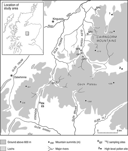
Table 1. Radiocarbon ages relating to the Main Holocene Terrace, central Grampians.
Additional radiocarbon ages obtained by Brazier & Ballantyne (Citation1989) relate to Late Holocene debris cones on the west bank of the River Feshie, 1.4 km upstream of the Feshie–Lorgaidh confluence. For in situ roots within a soil overlying a low terrace and buried by debris-flow deposits they obtained a radiocarbon age of 270 ± 50 14C a BP (cal AD 1476–1950), consistent within dating error with the lowest and youngest (∼80 a BP) terrace mapped by Robertson-Rintoul (Citation1986) at this location. Radiocarbon ages of 2090 ± 50 and 2020 ± 50 14C a BP (2.3–1.9 and 2.2–1.9 cal ka) were also obtained from the base and top, respectively, of an organic soil overlying and buried by debris-flow deposits at the foot of the debris cones a short distance farther upstream. Although this buried soil is unrelated to the terrace sequence, it occurs only ∼0.3–0.5 m above the present river channel, suggesting that at ∼2.3–1.9 ka the floodplain upstream from the Feshie-Lorgaidh confluence lay close to its present level.
The Glen Tromie trough lies 7–10 km west of Glen Feshie () and the River Tromie also drains northwards into the River Spey. The Edendon Valley is the southwards continuation of Glen Tromie and is drained to the south by Edendon Water, a tributary of the River Garry. Both valleys support low-level river terraces, the uppermost of which is equivalent to the MHT in Glen Feshie, but the full terrace sequence in these valleys has not been surveyed.
3. Radiocarbon ages relating to the main Holocene terrace
Samples for radiocarbon dating were collected by removing overlying deposits so that the upper surface of the material to be dated was exposed. Samples were extracted using a spatula or trowel, wrapped in aluminium foil then placed in airtight polythene bags. summarises the radiocarbon ages obtained for samples of organic material recovered from below the surface of the MHT in Glen Feshie, Glen Tromie and the Edendon Valley. These ages constrain the timing of an episode of floodplain or fan aggradation that terminated when the parent rivers subsequently incised their floodplains. For the Edendon Valley and upper Glen Feshie, additional ages were obtained (samples ES-1, EN-2 and GF-3) from the base of peat overlying, or organic soil developed on, the MHT surface. These ages constrain the timing of the subsequent incision of the MHT.
3.1. The Edendon valley samples
In the upper Edendon Valley, a small Late Holocene alluvial fan overlies a low-level terrace, 2.1 m above the active floodplain, and lateral migration of the Edendon Water has exposed a remarkably complete section across the fan and the underlying terrace. The detailed stratigraphy of this site is illustrated in Ballantyne and Whittington (Citation1999). The age of the terrace is closely constrained by the age of a peat layer buried by alluvial gravels, 29 cm below the terrace surface (EN-1, ∼2.8 cal ka), and those of two samples from the base of the peat overlying the terrace (ES-1 and EN-2, ∼2.7–2.2 cal ka and ∼2.8–2.4 cal ka). Collectively, these ages imply that floodplain aggradation probably ceased between ∼2.8 cal ka and ∼2.4 cal ka and was thereafter succeeded by net floodplain incision.
3.2. Upper Glen Feshie (samples GF-1, GF-2 and GF-3)
In upper Glen Feshie, the MHT on the floor of the main valley can be traced up the tributary valley of the Allt Lorgaidh, where it forms the uppermost Holocene surface of a large, relict, low-gradient alluvial fan, the Allt Lorgaidh fan (). Samples GF-1 and GF-2 consisted of charcoal fragments, 2–3 cm in size, extracted from the organic-rich A horizons of podzols buried under 95 and 45 cm, respectively, of fluvial sands and gravels (). Sample GF-1 was obtained from a riverbank exposure near the distal end of the fan near the confluence of the Allt Lorgaidh with the River Feshie, and sample GF-2 from an exposure at the margin of the MHT above the active floodplain of the Feshie, 300 m north of GF-1. The two samples produced overlapping ages of ∼4.1–3.8 cal ka (GF-1) and ∼4.0–3.6 cal ka (GF-2), implying that aggradation of fluvial sediments at the Feshie-Lorgaidh confluence culminated after ∼4.0–3.8 cal ka.
Figure 2. Oblique view of upper Glen Feshie, viewed from the south, showing the sampling locations of samples GF-1, GF-2 and GF-3. GF-3 (56.9976°N, 3.9046°W) is approximately 1.2 km upvalley from GF-1. MHT: Main Holocene Terrace (Google EarthTM image).
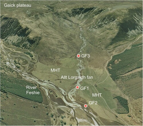
Figure 3. Sections showing the stratigraphic context of the Glen Feshie and Glen Tromie samples; note the differences in vertical scale. The stratigraphy of the Edendon Valley sampling sites is illustrated in Ballantyne and Whittington (Citation1999).
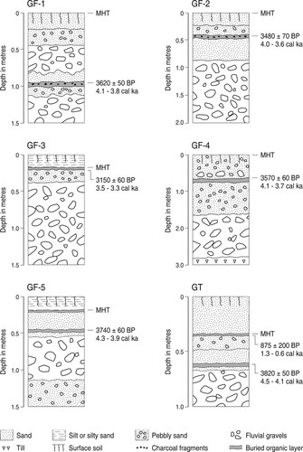
Sample GF-3 was obtained from a riverbank exposure 1.2 km farther up the Allt Lorgaidh fan () and was extracted from the top of the humic A horizon of a podzol buried under 17 cm of silty sand (). This organic horizon can be traced laterally to the surface of the MHT, and the overlying silty sands are interpreted as representing overbank deposition that occurred locally near the fan apex after formation of the MHT. The section abuts a lower terrace about a metre below the level of the MHT. The age obtained for sample GF-3 (∼3.5–3.3 cal ka) is therefore minimal for subsequent fan-head entrenchment, suggesting that the age of the MHT in the upper Glen Feshie lies between ∼4.0–3.8 cal ka and ∼3.5–3.3 cal ka, with the caveat that evidence of incision at one dated site need not necessarily imply synchronous incision farther downstream (Richards, Citation2002). As noted above, the radiocarbon ages obtained for a buried soil ∼0.3–0.5 m above the present channel 1.4 km upstream from the Feshie–Lorgaidh confluence (Brazier & Ballantyne, Citation1989) suggest that the floodplain in upper Glen Feshie lay close to its present level at 2.3–1.9 cal ka, consistent with floodplain incision after ∼3.5–3.3 cal ka.
3.3. Glen Feshie tributary fan samples (GF-4 and GF-5)
Sample GF-4 was obtained from a riverbank exposure in the MHT on an east-bank tributary fan, the Allt Fhearnagan fan, 5.2 km north of the Feshie-Lorgaidh confluence (). The sample was extracted from the top of the uppermost organic (A) horizon of a soil buried under 73 cm of fluvial sands and gravels () and yielded an age of ∼4.1–3.7 cal ka, similar to those of samples GF-1 and GF-2, and implying that Holocene sediment aggradation at this site probably also peaked after ∼4.0 cal ka.
Sample GF-5 was extracted from an exposure in the highest Holocene terrace on the Allt a’ Mharcaidh fan in the northern part of the Feshie catchment, 13 km north of the Feshie-Lorgaidh confluence (). The sample was extracted from the top of a 5 cm thick humic A horizon, underlain by fluvial gravels and overlain by 27cm of coarse sand in which an immature podzol has developed at the MHT surface. The terrace surface at this exposure is overlain by 17 cm of silt representing overbank deposition subsequent to the formation of the terrace-surface podzol. Sample GF-5 yielded a calibrated age of ∼4.3–3.9 cal ka that overlaps the calibrated age range of samples GF-1, GF-2 and GF-4.
3.4. The Glen Tromie samples
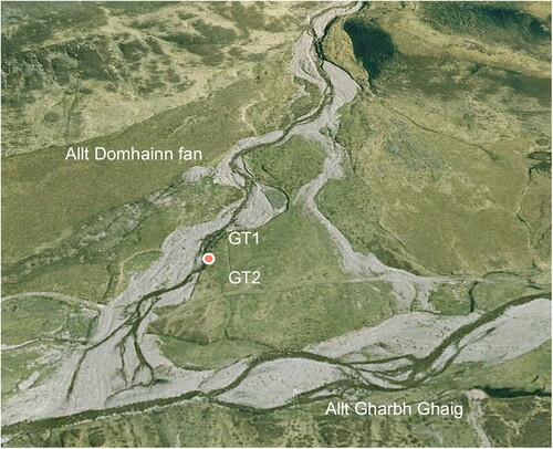
The MHT in upper Glen Tromie merges with that of an alluvial fan deposited by the Allt Domhainn, which drains into the Allt Gharbh Ghaig, an east-bank tributary of the River Tromie (). A riverbank section in the fan revealed two organic layers, both representing the humic horizons of buried soils, separated by 25 cm of sand and pebbly sand (). The lower organic horizon, which overlies coarse fluvial gravels, lies ∼1.3 m above the present channel and yielded a calibrated age range of ∼4.5–4.1 cal ka (sample GT-2), slightly older than those of the upper Glen Feshie sub-terrace samples (GF-1, GF-2 and GF-4). The upper organic horizon comprises the humic A or possibly bH horizon of a buried podzol and yielded an age (sample GT-1) of 1.3–0.6 cal ka. This upper organic horizon represents the former surface of the MHT farther down the fan, but at the exposed section is overlain by 34 cm of sandy overbank flood deposits.
Figure 4. Oblique view of the Allt Domhainn Fan (56.9925°N, 4.0269°W) viewed from the southwest in 2005, showing the location of the site from where samples GT-1 and GT2 were obtained. The distance from the apex of the fan to its toe is 350 m. The toe of the fan is partly truncated by the Allt Gharbh Ghaig, a tributary of the River Tromie (Google EarthTM image).
3.5. Interpretation
All of the sub-terrace radiocarbon ages reported above indicate that the MHT in the Edendon Valley, Glen Feshie and upper Glen Tromie represent Late Holocene fluvial sediment aggradation that culminated a few metres above the adjacent active floodplains or, in the case of the fan terraces, above the present river channel. The depth (≤ 95 cm) of the organic horizons from which the samples for radiocarbon dating were obtained, however, implies that sediment aggradation above previous floodplain or fan surfaces to the level of the MHT was limited. In the Edendon Valley the culmination of aggradation occurred at ∼2.8–2.5 cal ka, and in upper Glen Feshie it probably occurred between ∼4.0–3.8 cal ka and ∼3.5–3.2 cal ka. The latter age range is consistent with Robertson-Rintoul’s (Citation1986) inferred age for this terrace, and also with the calibrated age ranges of the sub-terrace samples GF-4 (∼4.1–3.7 cal ka), GF-5 (∼4.3–3.9 cal ka) and GT-2 (∼4.5–4.1 cal ka), all of which are minimal for the culmination of sediment aggradation to the level of the MHT. Given that all sub-terrace samples were retrieved from depths of ≤ 95 cm below terrace surfaces, it is likely that sediment accumulation terminated soon after burial of the of the dated organic material, suggesting that the MHT in upper Glen Feshie (samples GF-1, GF-2 and GF-4) represent near-synchronous floodplain and fan aggradation after ∼4.0–3.8 cal ka, but that the level of the MHT on the Allt a’ Mharcaidh fan (sample GF-5) and the Allt Domhainn fan in Glen Tromie (sample GT-2) could either be synchronous with the upper Feshie MHT or slightly older. The younger ages marking the culmination of the MHT in the Edendon Valley, however, imply that the MHT is a diachronous landform, even in valleys emanating from the same upland source areas. Our chronological evidence nonetheless demonstrates that after ∼4.5 cal ka the various dated floodplains and tributary fans in the Edendon-Feshie-Tromie systems experienced net aggradation followed by net incision.
Low Holocene terraces are present in broad straths and low-gradient tributary fans in many parts of the Scottish Highlands but additional dating evidence is limited to three radiocarbon ages (4000 ± 45, 3925 ± 45 and 4045 ± 45 14C a BP) reported by Reid et al. (Citation2003) for samples from the base of peat overlying a low floodplain terrace in Glen Licht (NW Highlands). These dates suggest that the low terrace at this site represents the level of the floodplain at ∼4.6–4.3 cal ka, but there is no evidence to confirm that sediment aggradation preceded terrace formation; these dates are, however, maximal for subsequent floodplain incision at this site.
4. Holocene environmental change in the central Grampian Highlands
4.1. Evidence of pine forest decline in headwater areas
The evidence provided by radiocarbon-dated pine stumps and pollen assemblages suggests that Scots Pine (Pinus sylvestris) was present in the region by ∼8.3 cal ka (Birks, Citation1970; Birks & Mathewes, Citation1978; O’Sullivan, Citation1976) and subsequently replaced birch (Betula pubescens) as the dominant tree species. By ∼7.8 cal ka, pine formed dense, closed-canopy woodland up to ∼700 m OD, with evidence of more localised pine colonisation at higher altitudes (Binney, Citation1997; Dubois & Ferguson, Citation1985). The pine forest probably achieved its maximum extent in the Cairngorms and adjacent areas between ∼7.8 and ∼5.7 cal ka (Pratt, Citation2006).
Pine stumps at 480–710 m altitude in in the Cairngorms have returned radiocarbon ages of ages of ∼5.5–3.6 cal ka, suggesting that this period was generally one of pine decline on high ground associated with fragmentation of the forest canopy and lowering of the treeline (Dubois & Ferguson, Citation1985). More locally, a high-level (510 m OD) site in upper Glen Geldie, 5 km from the headwaters of the River Feshie, has yielded evidence of progressive reduction in pine pollen and extension of dwarf shrubs (particularly Calluna vulgaris) after ∼4.8 cal ka. This evidence was interpreted by Paterson (Citation2011) as evidence of canopy fragmentation and development of increasingly open woodland, culminating in complete disappearance of trees by ∼2.8 cal ka or earlier. Similarly, at a high-level (500 m OD) site in Glen Einich (8 km east of Glen Feshie), Binney (Citation1997) detected a decline in pine pollen after ∼4.7 cal ka following a local shift to wetter conditions; by 4.3–4.0 cal ka, Calluna heath predominated, with complete or near-complete disappearance of woodland at this site.
At the upper Edendon Valley site (450 m OD) trees are now absent and the present vegetation cover is dominated by Calluna heath and herbaceous species. Pine stumps are, however, abundant in valley-side peat, suggesting that pine forest once dominated the local vegetation cover. Pollen analyses of both the sub-terrace peat (∼2.8 cal ka) and overlying terrace peat (∼2.7–2.4 cal ka) at this site revealed that both contained limited amounts of pine pollen (< 20% of total land pollen), and greater representation of grasses and sedges (Ballantyne & Whittington, Citation1999). This evidence suggests that fragmentation of the pine forest occurred prior to the episode of floodplain aggradation and incision now represented by the MHT in the Edendon Valley.
Collectively, the evidence outlined above suggests that widespread pine decline and lowering of the closed-canopy treeline occurred both near Glen Feshie and in the Edendon Valley prior to the period of floodplain and fan aggradation in these valleys, with associated replacement of woodland by dwarf shrubs, grasses and/or sedges in headwater areas above (and possibly below) 450–500 m OD. The causes of pine decline are debatable. Although there is some evidence of anthropogenic woodland clearance on low ground at Loch Garten (∼20 km NE of upper Glen Feshie) by ∼4.0 cal ka (O’Sullivan, Citation1974), it is more likely that on higher ground the reduction in forest cover after ∼4.8 cal ka was due to increasing wetness and spread of ombotrophic blanket peat that inhibited pine regeneration (Binney, Citation1997; Birks, Citation1975; Paterson, Citation2011). It is also possible that decline in woodland cover may have been accelerated by volcanic acid loading from the Hekla-4 eruption on Iceland in 4.26 cal ka (Blackford et al., Citation1992; Pratt, Citation2006); an exceptionally high concentration of tephra shards relating to this eruption occurs within peat deposits at Mallachie Moss, ∼10 km NE of Glen Feshie (Langdon, Citation1999).
4.2. Periods of wetter or cooler climate
Studies based on macrofossils, peat humification and testate amoebae assemblages at bogs and mires in Scotland have identified several Holocene periods of wetter and/or cooler conditions associated with water-table rise (Anderson, Citation1998; Charman, Citation2010; Langdon et al., Citation2003), but at present there is no evidence that Early and Middle Holocene periods of enhanced wetness were associated with floodplain or fan aggradation prior to the beginning of the Late Holocene at ∼4.2 cal ka. For the Late Holocene, Anderson et al. (Citation1998) detected a sustained increase in wetness from ∼3.9 to ∼3.5 cal ka in the NW Highlands, Langdon and Barber (Citation2005) identified marked increases in wetness in northern Scotland centred around ∼4.0, ∼3.6 and ∼2.7 cal ka, and Charman et al. (Citation2006) proposed Scotland-wide periods of increased wetness at ∼3.6 and 2.8–2.7 cal ka. All authors, however, note that there is some regional asynchrony in the timing of some wet shifts and dry shifts.
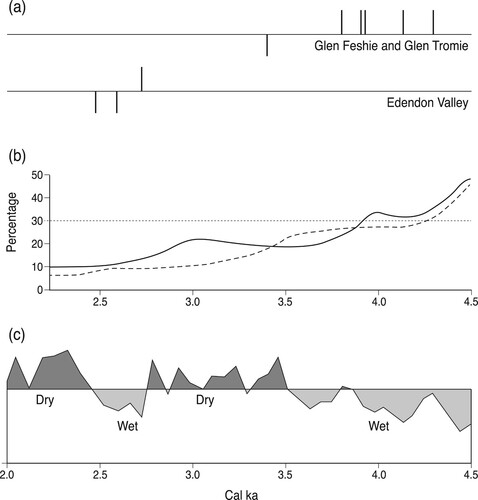
For the central Grampians and Cairngorms, a detailed record of phases of wetter and drier climate is available for Mallachie Moss in Abernethy Forest, 10 km NE of lower Glen Feshie (Langdon, Citation1999; Langdon & Barber, Citation2005). At this site, the combined evidence provided by peat humification, testate amoebae assemblages and plant macrofossils indicates generally wet conditions and high water tables from ∼4.8 cal ka to ∼3.6 cal ka, interrupted by briefer drier phases and succeeded by more generally drier conditions from ∼3.5 to ∼2.9 cal ka, then by renewed wet conditions that culminated at ∼–2.7 cal ka (). The wetter conditions from ∼4.8 to ∼3.6 cal ka provide support for the premise that coeval reduction in pine cover is attributable to spread of blanket peat that inhibited pine regeneration.
Figure 5. Environmental changes in the study area, 4.5–2.0 cal ka. (a) Maximal ages for floodplain and fan aggradation (upticks) and incision (downticks) as represented by the sub-terrace and supra-terrace radiocarbon ages obtained in Glen Feshie and Glen Tromie (top) and the Edendon Valley (bottom). The ticks represents the median calibrated radiocarbon age. (b) The trajectory of decline in pine woodland cover as represented by Pinus sylvestris pollen as a percentage of total land pollen; 30% approximates the point at which only isolated stands of pine occurred at the pollen sites. Curve 1 (dashed line) is for 500 m in Glen Einich, based on data in Binney (Citation1997); curve 2 is for 510 m at Geldie Lodge, based on data in Paterson (Citation2011). (c) Standardised records of periods of increased wetness (below the line) and dryness (above the line) at Mallachie Moss (Langdon & Barber, Citation2005).
5. Discussion
As illustrates, the timing of floodplain and fan aggradation at Glen Feshie, Glen Tromie and the Edendon Valley coincides with wetter periods, when water tables were high, potentially promoting an increase in the magnitude and frequency of extreme runoff events. There is no evidence in any of these valleys, however, for floodplain or fan aggradation during wetter periods earlier in the Holocene. We interpret this apparent anomaly in terms of progressive canopy fragmentation and loss of tree cover in headwater and tributary catchments, which appears to have culminated in the western Cairngorms with complete or near-complete pine woodland decline on ground at or above 500 m by ∼4.3–4.0 cal ka (Binney, Citation1997). A plausible scenario is that canopy loss triggered accelerated erosion of tributary catchments during extreme storm events, causing a pronounced increase in sediment discharge, and consequent aggradation of the upper Glen Feshie floodplain and its adjacent low-gradient tributary fans as envisaged by Richards (Citation2002, p. 153). In upper Glen Feshie this occurred within the period ∼4.1–3.7 cal ka to ∼3.5–3.2 cal ka, and possibly slightly earlier in the case of the Allt a’ Mharcaidh fan and the Allt Domhainn fan. We acknowledge, however that the links between the environmental changes outlined above and stream response were probably complex (Richards, Citation2002). Within the interval from ∼4.1 to ∼3.2 cal ka the various sub-catchments are unlikely to have responded uniformly to particular storm events (particularly short-duration localised storm events) because of differences in location, area, topography and channel slope. Extensive woodland decline and increased wetness may have increased susceptibility to increased flashiness of stream response and increased sediment discharge from tributary catchments, but do not imply a synchronous catchment-wide response to particular storm events.
As noted above, floodplain aggradation in the upper Edendon Valley culminated much later, at ∼2.8–2.5 cal ka, during a later period of wet conditions (). Floodplain aggradation at this site also occurred after fragmentation of pine cover, but here the timing of pine decline is undated. It is possible that the earlier period of prolonged wetness evident in the Mallachie Moss data had more limited effect on this this south-draining catchment, or that that fragmentation of the forest cover was later or slower, thus delaying accelerated erosion of tributary catchments feeding Edendon Water. Neither interpretation can be substantiated on present evidence.
Although periods of enhanced wetness have been identified at various sites in Scotland and elsewhere in the British Isles during the Early and Middle Holocene (Anderson, Citation1998; Anderson et al., Citation1998; Charman, Citation2010; Charman et al., Citation2006; Langdon & Barber, Citation2005), there is no morphological, stratigraphic or dating evidence to suggest that these produced episodes of floodplain or fan aggradation in the upper Edendon Valley, Glen Feshie or Glen Tromie. The dating evidence for floodplain and fan aggradation outlined above therefore suggests that progressive loss of tree cover in headwater sites above 450–500 m in the Cairngorms and adjacent areas after ∼4.7 cal ka was critical in increasing runoff response in tributary catchments, and their susceptibility to sediment entrainment during extreme rainstorms.
The coincidence of timing of the episodes of Late Holocene floodplain and fan aggradation with periods of enhanced wetness that occurred after forest decline in headwater catchments provides independent support for the simulation models of Coulthard et al. (Citation2000, Citation2002, Citation2005), Coulthard and Macklin (Citation2001) and Coulthard and Van De Wiel (Citation2017). As outlined in the introduction, these models predict a major increase in sediment discharge when woodland loss is followed by a period of increased precipitation. This general model suggests that in the Central Grampians, a marked increase in sediment discharge fed sediment aggradation on low-gradient floodplains and fans downstream, to the level now represented by the MHT. Such models also suggest that aggradation of floodplain or fan surfaces due to enhanced erosion of upstream source areas during wet periods following woodland loss may be succeeded by net incision, possibly due to exhaustion of readily entrained sediment in tributary valleys (Coulthard & Macklin, Citation2001), thus providing a possible explanation for the subsequent abandonment and entrenchment of the MHT by the parent rivers and their tributaries. Given the limited dating evidence for the timing of terrace incision, however, it cannot be assumed that this occurred synchronously, even within upper Glen Feshie and its tributary valleys.
6. Conclusions
Radiocarbon dates obtained from organic material within floodplain and fan terraces in three valleys that drain the Gaick Plateau imply that the highest Holocene terrace (Main Holocene Terrace, MHT) in these valleys represents an episode of floodplain and fan aggradation after ∼4.1–3.7 cal ka in upper Glen Feshie, ∼4.3–4.0 cal ka at a tributary fan in lower Glen Feshie, and ∼4.5–4.1 cal ka at a tributary fan in neighbouring Glen Tromie. The culmination of sediment aggradation in the upper Edendon Valley occurred later, after ∼2.8 cal ka. Radiocarbon ages obtained from peat or organic soils immediately overlying the MHT suggest abandonment and incision of this terrace by ∼3.5–3.3 cal ka in upper Glen Feshie and ∼2.7–2.4 cal ka in the Edendon Valley. The MHT is therefore a diachronous Late Holocene feature that differs in age even in valleys emanating from the same high ground.
Floodplain and fan aggradation at all sites followed extensive reduction of pine forest cover after ∼4.8 cal ka at nearby high-level sites, culminating at one site in complete or near-complete disappearance of woodland by ∼4.3–4.0 cal ka, but may have been later in the upper Edendon catchment. Floodplain and fan aggradation to the level of the MHT also coincided with generally wet periods characterised by high water tables and enhanced flood runoff at ∼4.8–3.6 cal ka (in Glen Feshie and Glen Tromie) and ∼2.8–2.5 cal ka (in the Edendon Valley).
From these coincidences in timing, we infer: (i) that reduction and eventual disappearance of forest cover in the upper parts of the three catchments triggered upstream extension of the tributary network, headwater incision and flashier flood responses to rainstorms during episodes of enhanced wetness; (ii) that that such changes resulted (though not necessarily simultaneously) in a marked increase in sediment discharge from headwaters; and (iii) that consequent deposition of sediment on the low-gradient floodplains and tributary fans resulted in Late Holocene sediment aggradation to the level of the MHT. More speculatively, subsequent floodplain and fan incision leading to formation of the MHT may have been due to exhaustion of readily entrained sediment in tributary valleys, with consequent resetting of alluvial systems to lower topographic levels. Our findings provide independent support for simulation models that a marked increase is sediment discharge occurs when extensive loss of forest cover precedes or occurs during periods of enhanced rainfall.
Acknowledgements
Graeme Sandeman (University of St Andrews) is thanked for drafting the figures. Two anonymous reviewers and the Associate Editor, Dr Martin Hurst, provided helpful comments that improved the content of this paper.
Disclosure statement
No potential conflict of interest was reported by the author(s).
References
- Aitken, J. F. (1998). Sedimentology of Late Devensian glaciofluvial outwash in the Don valley, Grampian region. Scottish Journal of Geology, 34(2), 97–117. https://doi.org/10.1144/sjg34020097
- Anderson, D. E. (1998). A reconstruction of Holocene climatic changes from peat bogs in north-west Scotland. Boreas, 27(3), 208–224. https://doi.org/10.1111/j.1502-3885.1998.tb00880.x
- Anderson, D. E., Binney, H. A., & Smith, M. A. (1998). Evidence for abrupt climatic change in northern Scotland between 3900 and 3500 calendar years BP. The Holocene, 8(1), 97–103. https://doi.org/10.1191/095968398669507604
- Auton, C. A. (1990). The middle Findhorn valley. In C. A. Auton, C. R. Firth, & J. W. Merritt (Eds.), Beauly to Nairn: Field Guide (pp. 74–96). Quaternary Research Association.
- Ballantyne, C. K. (2008). After the Ice: Holocene geomorphic activity in the Scottish highlands. Scottish Geographical Journal, 124(1), 8–52. https://doi.org/10.1080/14702540802300167
- Ballantyne, C. K. (2019). After the ice: Lateglacial and Holocene landforms and landscape evolution in Scotland. Earth and Environmental Science Transactions of the Royal Society of Edinburgh, 110(1-2), 133–171. https://doi.org/10.1017/S175569101800004X
- Ballantyne, C. K., & Small, D. (2019). The last Scottish Ice Sheet. Earth and Environmental Science Transactions of the Royal Society of Edinburgh, 110(1-2), 93–131. https://doi.org/10.1017/S1755691018000038
- Ballantyne, C. K., & Whittington, G. W. (1999). Late Holocene floodplain incision and alluvial fan formation in the central Grampian Highlands, Scotland: Chronology, environment and implications. Journal of Quaternary Science, 14(7), 651–671. https://doi.org/10.1002/(SICI)1099-1417(199912)14:7<651::AID-JQS469>3.0.CO;2-1
- Binney, H. A. (1997). Holocene environmental change in the Scottish Highlands: Multi-proxy evidence from blanket peats. PhD thesis, London Guildhall University, 342 pp.
- Birks, H. H. (1970). Studies in the vegetational history of Scotland: I. A pollen diagram from Abernethy Forest, Inverness-shire. The Journal of Ecology, 58(3), 827–846. https://doi.org/10.2307/2258536
- Birks, H. H. (1975). Studies in the vegetational history of Scotland IV. Pine stumps in Scottish blanket peats. Philosophical Transactions of the Royal Society of London. B, Biological Sciences, B270, 181–226. https://doi.org/10.1098/rstb.1975.0007
- Birks, H. H., & Mathewes, R. W. (1978). Studies in the vegetational history of Scotland. V. Late Devensian and Early Flandrian pollen and macrofossil stratigraphy at Abernethy Forest, Inverness-shire. New Phytologist, 80(2), 455–484. https://doi.org/10.1111/j.1469-8137.1978.tb01579.x
- Blackford, J. J., Edwards, K. J., Dugmore, A. J., Cook, G. T., & Buckland, P. C. (1992). Icelandic volcanic ash and the mid- Holocene Scots pine (Pinus sylvestris) pollen decline in northern Scotland. The Holocene, 2(3), 260–265. https://doi.org/10.1177/095968369200200308
- Brazier, V., & Ballantyne, C. K. (1989). Late Holocene debris cone evolution in Glen Feshie, western Cairngorm Mountains, Scotland. Transactions of the Royal Society of Edinburgh: Earth Sciences, 80(1), 17–24. https://doi.org/10.1017/S0263593300012244
- Bronk Ramsey, C. (2009). Bayesian analysis of radiocarbon dates. Radiocarbon, 51(1), 337–360. https://doi.org/10.1017/S0033822200033865
- Charman, D. J. (2010). Centennial climate variability in the British Isles during the mid-late Holocene. Quaternary Science Reviews, 29(13-14), 1539–1554. https://doi.org/10.1016/j.quascirev.2009.02.017
- Charman, D. J., Blundell, A., Chiverrell, R., Henson, D., & Langdon, P. G. (2006). Compilation of non-annually resolved Holocene proxy climate records: Stacked Holocene peatland palaeo-water table reconstructions from northern Britain. Quaternary Science Reviews, 25(3-4), 336–350. https://doi.org/10.1016/j.quascirev.2005.05.005
- Coulthard, T. J., Kirkby, M. J., & Macklin, M. G. (2000). Modelling geomorphic response to environmental change in an upland catchment. Hydrological Processes, 14(11-12), 2031–2045. https://doi.org/10.1002/1099-1085(20000815/30)14:11/12<2031::AID-HYP53>3.0.CO;2-G
- Coulthard, T. J., Lewin, J., & Macklin, M. G. (2005). Modelling differential catchment response to environmental change. Geomorphology, 69(1-4), 222–241. https://doi.org/10.1016/j.geomorph.2005.01.008
- Coulthard, T. J., & Macklin, M. G. (2001). How sensitive are river systems to climate and land-use changes? A model-based evaluation. Journal of Quaternary Science, 16(4), 347–351. https://doi.org/10.1002/jqs.604
- Coulthard, T. J., Macklin, M. G., & Kirkby, M. J. (2002). A cellular model of Holocene upland river basin and alluvial fan evolution. Earth Surface Processes and Landforms, 27(3), 269–288. https://doi.org/10.1002/esp.318
- Coulthard, T. J., & Van De Wiel, M. J. (2017). Modelling long term basin scale sediment connectivity, driven by spatial land use changes. Geomorphology, 277, 265–281. https://doi.org/10.1016/j.geomorph.2016.05.027
- Dubois, A. D., & Ferguson, D. K. (1985). The climatic history of pine in the Cairngorms based on radiocarbon dates and stable isotope analysis, with an account of the events leading up to its colonization. Review of Palaeobotany and Palynology, 46(1-2), 55–80. https://doi.org/10.1016/0034-6667(85)90038-7
- Langdon, P. G. (1999). Reconstructing Holocene climate change in Scotland utilising peat stratigraphy and tephrochronology. [PhD thesis]. University of Southampton, 390 pp.
- Langdon, P. G., & Barber, K. E. (2005). The climate of Scotland over the last 5000 years inferred from multiproxy peatland records: Inter-site correlations and regional variability. Journal of Quaternary Science, 20(6), 549–566. https://doi.org/10.1002/jqs.934
- Langdon, P. G., Barber, K. E., & Hughes, P. D. M. (2003). A 7500-year peat-based palaeoclimatic reconstruction and evidence for an 1100-year cyclicity in bog surface wetness from Temple Hill Moss, Pentland Hills, southeast Scotland. Quaternary Science Reviews, 22(2-4), 259–274. https://doi.org/10.1016/S0277-3791(02)00093-8
- Maizels, J. K. (1983a). Channel changes, palaeohydrology and deglaciation: Evidence from some Lateglacial sandur deposits of northeast Scotland. Quaternary Studies in Poland, 4, 171–187.
- Maizels, J. K. (1983b). Modern and ancient fluvial systems. Special Publications of the International Association of Sedimentologists, 6, 251–266. https://doi.org/10.1002/9781444303773.ch20
- O’Sullivan, P. E. (1974). Radiocarbon-dating and prehistoric forest clearance on speyside (east-central Highlands of Scotland). Proceedings of the Prehistoric Society, 40, 206–208. https://doi.org/10.1017/S0079497X00011427
- O’Sullivan, P. E. (1976). Pollen analysis and radiocarbon dating of a core from Loch Pityoulish, eastern Highlands of Scotland. Journal of Biogeography, 3(3), 293–302. https://doi.org/10.2307/3038019
- Paterson, D. (2011). The holocene history of pinus sylvestris woodland in the Mar lodge estate. PhD thesis, University of Stirling, 346 pp.
- Pratt, S. (2006). Long-term landscape dynamics in a Caledonian pine forest [PhD thesis]. University of Edinburgh, 267 pp.
- Reid, E., Thomas, M. F., & Tipping, R. M. (2003). Holocene alluvial fan and fluvial activity in upper Glen Licht, Kintail. In R. M. Tipping (Ed.), The Quaternary of Glen Affric and Kintail: Field guide (pp. 157–164). Quaternary Research Association.
- Reimer, P. J., Austin, W. E., Bard, E., Bayliss, A., Blackwell, P. G., Ramsey, C. B., Butzin, M., Cheng, H., Edwards, R. L., Friedrich, M., & Grootes, P. M. (2020). The IntCal20 northern hemisphere radiocarbon age calibration curve (0–55 cal kBP). Radiocarbon, 62(4), 725–757. https://doi.org/10.1017/RDC.2020.41
- Richards, K. (2002). Drainage basin structure, sediment delivery and the response to environmental change. Geological Society, London, Special Publications, 191(1), 149–160. https://doi.org/10.1144/GSL.SP.2002.191.01.10
- Robertson-Rintoul, M. S. E. (1986). A quantitative soil-stratigraphic approach to the correlation and dating of post-glacial river terraces in Glen Feshie, western Cairngorms. Earth Surface Processes and Landforms, 11(6), 605–617. https://doi.org/10.1002/esp.3290110604
- Werritty, A. (2021). Fluvial landforms of Glen Feshie and the Spey drainage basin. In C. K. Ballantyne, & J. E. Gordon (Eds.), Landscapes and landforms of Scotland (pp. 349–358). Springer Nature. https://doi.org/10.1007/978-3-030-71246-4_19.
- Young, J. A. T. (1976). The terraces of Glen Feshie, Inverness-shire. Transactions of the Royal Society of Edinburgh, 69(22), 501–512. https://doi.org/10.1017/S0080456800015532
- Young, J. A. T. (1978). The landforms of upper Strathspey. Scottish Geographical Magazine, 94, 76–94. https://doi.org/10.1080/00369227808736394