
 ?Mathematical formulae have been encoded as MathML and are displayed in this HTML version using MathJax in order to improve their display. Uncheck the box to turn MathJax off. This feature requires Javascript. Click on a formula to zoom.
ABSTRACT
Surface heating is important in terms of the thermal effect of the Tibetan Plateau on atmospheric systems in Asia. The complex mountain terrain across the Tibetan Plateau introduces small-scale heterogeneity in the local atmosphere and land–air heat exchange that biases our understanding of the Tibetan thermal effect and misleads boundary-layer parameterization for numerical studies and predictions. It is therefore essentially important to evaluate heterogeneity in the Tibetan mountains. An observational experiment was conducted in a small region with a complex landscape in the eastern Himalayas from June 9 to July 9, 2013. This study analyzes the observations of three major land covers and discusses the observed heterogeneity of the local atmosphere and land–air heat exchange. A heterogeneity rate is defined to approximately quantify the heterogeneity observed in the atmospheric properties and land–air heat exchange. Obvious heterogeneity is found in the local atmosphere across the complex terrain of the Eastern Himalayas, which could introduce uncertainties up to 33.3 percent in our knowledge related to the local weather and climate. A large heterogeneity is revealed in the land–air heat exchange, which would bias our understanding of total surface heating in this region up to 16 percent and of heating properties up to 62 percent. Therefore, attention should be given to the uncertainties introduced by small-scale heterogeneity in any weather and climate studies across a complex terrain, such as the eastern Himalayas. In addition, the heterogeneity rate provided could be a useful measure to generally identify the uncertainties in our understanding of the local atmosphere and land–air heat exchange across a complex terrain.
Introduction
The Tibetan Plateau is one of the most important geographic features in the Northern Hemisphere, with an average elevation of more than 4,000 m and an area of approximately 2.3 × 10⁶ km2. The strong solar radiation on the elevated surface makes the plateau a heating source for the atmosphere, specifically the middle troposphere. Surface heating not only generates multiscale atmospheric motions on the plateau but also controls the synoptic and climate systems in Asia and impacts atmospheric circulations around the world (Ye and Gao Citation1979; Yanai, Li, and Song Citation1992; Zhou et al. Citation2008, Citation2009, Citation2011, Citation2012, Citation2013a, Citation2013b; Ma et al. Citation2013). Yanai, Li, and Song (Citation1992); He et al. (Citation1987); Wu and Zhang (Citation1998); and Wu et al. (Citation2012) revealed the impacts of Tibetan surface heating on the onset of the South Asian summer monsoon. Hsu and Liu (Citation2003) and Wang et al. (Citation2008) discovered the relationship between the heating source of the Tibetan Plateau and precipitation in East China. Huang (Citation1985) and Zhou et al. (Citation2009) showed the expanded impacts of Tibetan heating on atmospheric systems over the northern Atlantic region. Zou (Citation1996) and Zou and Gao (Citation1997) found the Tibetan ozone to be low and attributed it to ozone redistribution by Tibetan surface heating.
To understand surface heating across the Tibetan Plateau, Ye and Gao (Citation1980) investigated the land–air heat exchange based on the surface-air temperature contrast and evaporation at twenty-two weather stations, and noted that surface heating is much stronger across the plateau than across other low-altitude regions, especially in summer. In follow-up studies, improved measurements and techniques were applied to obtain near-surface turbulent heat transfer in different Tibetan regions. Gao et al. (Citation2000), Bian et al. (Citation2002), Zou et al. (Citation2009), and Li et al. (Citation1999) observed the land–air heat exchange at Nagqu (central Tibet), Qamdo (eastern Tibet), Mt. Everest (southern Tibet), and Gerze (western Tibet), respectively, in the same season—spring and early summer. They showed the total turbulent heat fluxes from the surface to the air in the range of 80.0–144.0 W/m2, with more sensible heat transfer in the range of 43.0–86.0 W/m2 and less latent heat transfer in the range of 28.0–59.0 W/m2. Zou et al. (Citation2012) measured the near-surface heat transfer in southeastern Tibet in early summer and found that the land–air heat transfer differed from the previous regions, with a total heat flux of 86.3 W/m2, a sensible heat flux of 22.9 W/m2, and a latent heat flux of 63.4 W/m2; that is, latent heat transfer dominates the land–air heat exchange with a Bowen ratio of 0.36 in this region. These measurements exhibit a large variability in the land–air heat exchange from region to region across the Tibetan Plateau, with an 80 percent difference in total heat transfer, a 275 percent difference in sensible heat transfer, and a 125 percent difference in latent heat transfer.
The Tibetan Plateau is covered by great mountain systems, such as the Himalayas, Gandies, Tanggula, and Kunlun. (Liao Citation1999). The land surface in these mountains is complex because of steep topography and diverse land covers, typically with an altitude gradient of thousands of meters and land covers of water, naked soil, grassland, forest, and snow appearing within 20 km. The dynamic and thermal processes across the complex land surface could generate heterogeneous local atmospheric systems in the Tibetan mountains (Egger et al. Citation2000; Hunt Citation1973; Hunt, Richards, and Brighton Citation1988; Ludecke and Kuhle Citation1991; Ma et al. Citation2013; Stull Citation1988; Taylor, Mason, and Bradley Citation1987; Zou et al. Citation2008, Citation2009). For instance, Bai et al. (Citation2007) demonstrated large differences in solar radiation and air temperatures between two observation sites at a distance of 13 km on the northern slope of Mt. Everest, and Zou et al. (Citation2008) found large wind differences between the two sites. Consequently, the land–air heat exchange in the Tibetan mountains could also have substantial small-scale heterogeneity driven by the surface and air conditions. The spatial scale of the heterogeneities in the local atmosphere and land–air heat exchange could be much smaller than the grids in most numerical models for weather and climate studies and predictions. This small-scale heterogeneity would cause great uncertainties in terms of understanding the local atmosphere and land–air heat exchange using one site observation in the Tibetan mountains. Therefore, former studies based on one site observation could not provide precise knowledge of the atmosphere and surface heating of the Tibetan Plateau. Furthermore, the subscale heterogeneity of the local atmosphere and land–air heat exchange could bias surface and boundary-layer parameterizations in numerical analyses and predictions. Thus, it is essentially important to investigate the heterogeneity in the local atmosphere and land–air heat exchange and estimate the degree of uncertainty brought by the heterogeneity across the complex surfaces of the Tibetan mountains.
The Eastern Himalayas and the Yarlung Tsangpo River in southwestern Tibet are a typical Tibetan mountainous region, with large altitude gradients and complex surfaces (Liao Citation1990). The land cover generally interweaves meadow, cropland, and forest in a very small area of 10 × 10 km2. Therefore, this region is considered an ideal experimental domain in which to study the heterogeneous land–air heat exchange in the Tibetan mountains. An observational campaign, Observation of Surface Exchange Processes (OSEP2013), was carried out by the Chinese Academy of Sciences in this region from June to July 2013. The campaign operated observation sites on three typical land surfaces and obtained high-quality data for the near-surface atmosphere and land–air heat exchange. Based on the OSEP2013 data, this study attempts to analyze the local atmosphere and land–air heat exchange on different land surfaces and discuss and quantify the heterogeneity in the atmosphere property and heat exchange in the Eastern Himalayas.
Observations and data
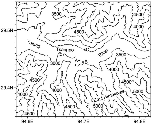
shows the topography of the OSEP2013 observational domain. In this region, the Eastern Himalayas elongates from west to east with a main ridge elevation of approximately 5,000 m, and the Yarlung Tsangpo River rushes eastward, north of the Eastern Himalayas, with a water surface elevation of approximately 2,920 m. The land surface in the river valley is mainly covered by meadow, with scattered Rosa multiflora thunb, cropland with irrigated hulless barley, and forests of Quercus spinosa, Pinus densata, Picea, and Abies on the slopes. Also, small portions of naked sandy soil and water surfaces are on the valley bottom. The observational campaign OSEP2013 was conducted in this valley in June and July 2013. Three observation sites were established on the meadow land (Site A; 29.449°N, 94.691°E, 2,973 m), cropland (Site B; 29.446°N, 94.698°E, 2,960 m), and short forest on the south-facing slope (Site C; 29.468°N, 94.701°E, 3,164 m). The meadow (Site A) had an average grass height of approximately 10 cm, the cropland (Site B) had an average hulless barley height of approximately 60 cm, and the slope (Site C) had an average Q. spinosa height of approximately 200 cm. The three sites were distributed with a relative distance of 756 m between Sites A and B, 2,319 m between Sites A and C, and 2,456 m between Sites B and C.
Figure 1. Topography (m) and observation sites: the meadow (Site A), cropland (Site B), and slope (Site C)
Global solar radiation and net radiation fluxes were measured by NR01 from HUKSEFLUX, and air temperature, water vapor density, and horizontal wind were measured by METPARK II from GILL at 1.5 m above the canopies at the three sites, with a sampling frequency of 1 min. The observed atmospheric properties were averaged every 10 min for the analysis. The soil temperature and water content were observed at a 2 cm depth by 109 L and CS616-L sensors, respectively, from CAMPELL, with 1 Hz sampling frequency and 10 min. average records. The turbulence heat fluxes were measured by an ultrasonic anemometer (Windmaster Pro from Gill) with sonic virtual temperature and CO2/H2O measurements (LI7500 from Li-Cor) at a sampling rate of 10 Hz, approximately 2.4 m above the canopies at the three sites. The calculations of vertical turbulent heat fluxes in this study were based on the conventional eddy-covariance technique, with a 30 min average and WPL correction (Brook Citation1978; Riehl, Greenhut, and Bean Citation1978; Stull Citation1988; Webb, Pearman, and Leuning Citation1980). All the observation instruments worked perfectly during the campaign, with only minimal data missing less than 0.5 percent in 10 Hz eddy measurements, and data quality control was carefully applied. All the diurnal variations and the relevant analysis in this study are based on the average from June 9 to July 9, 2013.
To quantify the heterogeneity of atmospheric properties and land–air heat exchanges, the heterogeneity rate is defined as the largest absolute percentage of the spatial bias to the spatial average of a concerned property in the investigation domain, as follows:
where HR denotes the heterogeneity rate, xi the atmospheric property at observation site i, and the average of the property at all sites. All the observation sites should be located on each of the typical and dominant land surfaces in the complicated terrain. Otherwise, the heterogeneity rate would be biased to a large degree. Although this heterogeneity rate is quite dependent on the domain and site selection, it could provide an approximate measure and reference, helping us understand the uncertainty or variability in the atmospheric properties and land–air heat exchange processes across a complex landscape.
The atmospheric conditions
In this section, the atmospheric circulation in South Asia and the local atmospheric conditions at the three observation sites are analyzed and discussed.
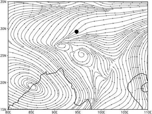
shows the average stream lines on 500 hPa in South Asia during OSEP2013. The South Asian summer monsoon (SASM) was established, and the Indian low was centered on the east coast of the Indian subcontinent, with small highs in its northeastern region (Ding Citation2007; Goswami et al. Citation2003; Webster et al. Citation1998; Zhou et al. Citation2015). The streams in the northeast of the Indian low brought warm and wet air in South Asia northwestward and the flows in the north of the small highs carried the air mass northeastward to the Eastern Himalayas. The atmospheric conditions in the observation domain were affected by SASM as a normal scenario in the Eastern Himalayas in early summer (Zou et al. Citation2009).
Figure 2. The stream lines on 500 hPa over South Asia during OSEP2013 from June 9 to July 9, with the observation domain denoted by a black dot
shows the solar shortwave and net radiation fluxes observed at the three sites. In (top), the global solar radiation flux has an average of 231 W/m2 and a maximum of 768 W/m2 at 11:30 at the meadow, an average of 237 W/m2 and a maximum of 793 W/m2 at 12:20 at the cropland, and an average of 240 W/m2 and a maximum of 812 W/m2 at 12:00 at the slope. The amounts of and diurnal variations in solar radiation observed at the three sites are very close to each other. However, the radiation measurements were horizontally taken at all sites. At the site on the south-facing slope, the solar radiation received should be higher than the other sites because of the higher actual solar elevation. The three-site average of solar radiation flux is calculated to be 236 W/m2, the largest bias in the average is found on the meadow at −5 W/m2, and the heterogeneity rate, as defined in the previous section, is obtained as 2.1 percent, indicating a uniform solar radiation input at the observation sites.
Figure 3. The diurnal variations in solar radiation (top) and net radiation (bottom) fluxes at the three observation sites, averaged from June 9 to July 9, 2013
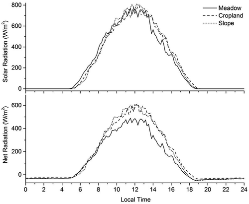
In (bottom), the net radiation flux has an average of 119 W/m2 and a maximum of 489 W/m2 at 11:30 at the meadow, an average of 158 W/m2 and a maximum of 612 W/m2 at 12:20 at the cropland, and an average of 153 W/m2 and a maximum of 610 W/m2 at 12:00 at the slope. The net radiation flux on the meadow is 23 percent lower than the average on the cropland and slope, indicating that less radiation energy is received by the meadow than the other areas because of the high reflection of the short grass on the meadow surface. Similar to the discussion on solar radiation, the net radiation received at the slope site should be higher than was measured. The three-site averaged net radiation flux is calculated as 143 W/m2, the largest bias is found on the meadow at −24 W/m2, and the heterogeneity rate of the net radiation is calculated as 17 percent. This result indicates more heterogeneity in the net radiation than in the solar radiation because of the stronger dependence of net radiation on surface reflectivity.
In addition, compared with the averaged solar and net radiation fluxes at 531.6 W m−2 and 131.6 W m−2, respectively, measured across the semiarid surface on the northern slope of Mt. Everest (the middle Himalayas) in June 2006 (Zou et al. Citation2008), the solar radiation is weaker in the Eastern Himalayas because of the lower elevation and higher moisture brought by the SASM circulation in this region (Zhou et al. Citation2015); however, the net radiation is larger because of the lower reflectivity on the vegetation surface.
provides the diurnal variations in the air and soil temperatures and air-water density during OSEP2013. In (top), the air temperature has an average of 17.1°C, a maximum of 23.1°C at 13:30, and a minimum of 12.3°C at 4:30 at the meadow; an average of 17.5°C, a maximum of 23.6°C at 13:50, and a minimum of 12.4°C at 5:00 at the cropland; and an average of 16.5°C, a maximum of 22.2°C at 12:20, and a minimum of 12.1°C at 4:50 at the slope. The air temperature has almost the same diurnal variations at the three sites and the lowest value at the slope because of the higher elevation. The three-site average temperature is calculated as 17.0°C, the largest bias is 0.5°C at the cropland and −0.5°C at the slope, and the heterogeneity rate is 2.9 percent. This result indicates a small spatial variability in air temperature at the three sites. Compared with the average air temperature of 7.2°C in the middle Himalayas in the same season (Zou et al. Citation2008), the air temperature is much higher in the Eastern Himalayas because of the lower elevation and the SASM impact in this region.
Figure 4. The diurnal variations in air temperature (top) and 2 cm soil temperature (middle) and water-vapor density (bottom) at the three observation sites, averaged from June 9 to July 9, 2013
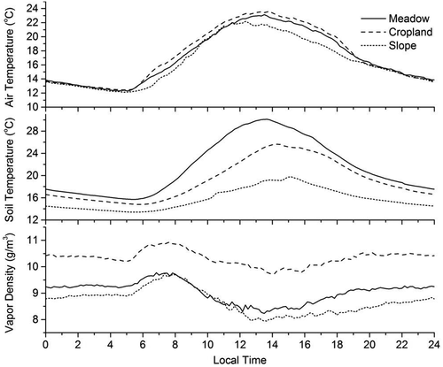
In (middle), the soil temperature at a 2 cm depth has an average temperature of 21.6°C, a maximum of 30.1°C at 13:40, and a minimum of 15.7°C at 5:20 at the meadow; an average of 17.5°C, a maximum of 26.1°C at 12:20, and a minimum of 10.9°C at 5:00 at the cropland; and an average of 15.8°C, a maximum of 19.2°C at 13:50, and a minimum of 13.4°C at 5:30 at the slope. The soil temperature obviously decreases with the canopy heights of the sites because of canopy shielding to solar radiation. The three-site averaged soil temperature is calculated as 18.3°C, the largest bias at the meadow is 3.3°C, and the heterogeneity rate is 18 percent. Therefore, the different canopy covers generate larger heterogeneity in the soil temperature distributions than the air temperature in the observation domain.
In (bottom), the water-vapor density has an average of 9.0 g/m3, a maximum of 9.8 g/m3 at 6:50, and a minimum of 8.2 g/m3 at 13:30 at the meadow; an average of 10.3 g/m3, a maximum of 10.9 g/m3 at 7:40, and a minimum of 9.7 g/m3 at 13:50 at the cropland; and an average of 8.9 g/m3, a maximum of 9.8 g/m3 at 7:20, and a minimum of 7.9 g/m3 at 13:40 on the slope. The water vapor has the same diurnal variations at the three sites, with high values in the morning and low values in the afternoon. The water-vapor density at the cropland is much higher than that at the meadow and slope sites because of the large surface evaporation and vegetation respiration under regular irrigation. The three-site averaged water-vapor density is 9.4 g/m3, the largest bias is at the cropland at 0.9 g/m3, and the heterogeneity rate of the water-vapor distribution is 9.6 percent. The water-vapor density observed in the Eastern Himalayas is much higher than the measurement of 3.0 g/m3 in the middle Himalayas (Zou et al. Citation2008) because of the geographic features and the SASM impact (Zhou et al. Citation2015).
shows the diurnal variation in the surface wind averaged during OSEP2013. In (top), the westerly component of the surface wind has an average speed of −1.6 m/s, a maximum of 0.9 m/s at 18:20, and a minimum of −2.3 m/s at 13:20 at the meadow; an average of −0.4 m/s, a maximum of 0.4 m/s at 18:50, and a minimum of −2.6 m/s at 13:40 at the cropland; and an average of −0.3 m/s, a maximum of 0.6 m/s at 8:30, and a minimum of −1.4 m/s at 13:20 at the slope. The diurnal variation has an easterly from the morning (approximately 10:00) to sunset (approximately 18:00) and a weak westerly, or calm wind, in the rest period. Because the westerly component is parallel to the valley, the previous diurnal variation shows a clear valley wind in the Yarlung Tsangpo Valley, as discussed previously by Xu et al. (Citation2014). The three-site averaged westerly speed is calculated as −0.8 m/s, the largest bias on the meadow is −0.8 m/s, and the heterogeneity rate in the westerly is 100 percent.
Figure 5. The diurnal variations in westerly (top) and southerly (middle) winds and overall wind speed (bottom) at the three observation sites, averaged from June 9 to July 9, 2013
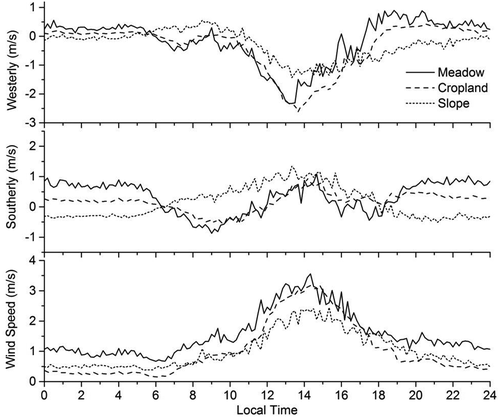
In (middle), the southerly component of surface wind has an average speed of 0.3 m/s, a maximum of 1.1 m/s at 14:40, and a minimum of −0.9 m/s at 9:00 at the meadow; an average of 0.2 m/s, a maximum of 1.0 m/s at 14:10, and a minimum of −0.6 m/s at 9:40 at the cropland; and an average of 0.1 m/s, a maximum of 1.3 m/s at 13:20, and a minimum of −0.5 m/s at 21:10 at the slope. The southerly component, perpendicular to the valley axis, is generally weak at the three sites because of the regulation of the topography. In addition, an upslope flow (southerly) in the afternoon can be found at the site on the south-facing slope. The three-site averaged southerly is 0.2 m/s, the absolute value of the largest bias at the meadow and slope is 0.1 m/s, and the heterogeneity rate of the southerly is 50 percent.
In (bottom), the wind speed has an average of 1.6 m/s, a maximum of 3.6 m/s at 14:20, and a minimum of 0.7 m/s at 6:00 at the meadow; an average of 1.0 m/s, a maximum of 3.2 m/s at 14:50, and a minimum of 0.2 m/s at 6:00 at the cropland; and an average of 1.0 m/s, a maximum of 2.4 m/s at 14:10, and a minimum of 0.4 m/s at 5:20 at the slope. The wind speed has similar diurnal variations, with maxima in the early afternoon and minima in the early morning. The three-site averaged wind speed is calculated as 1.2 m/s, the largest bias at the meadow is 0.3 m/s, and the heterogeneity rate is 33.3 percent. The heterogeneity rates for the wind components and overall speed indicate a large impact of topography on the wind distribution in the Eastern Himalayas.
Based on this analysis, summarizes the averages, maximum biases, and heterogeneities in the atmospheric parameters observed at the three sites. The biases and heterogeneities in the solar radiation and air temperature are small, indicating that ignoring the heterogeneity would not result in large errors in a general study in the Tibetan mountains. However, attention should be given to the fact that the larger the elevation gradient, the greater the heterogeneities in atmospheric temperature. The heterogeneity in the water-vapor density is close to 10 percent, implying an important impact from the soil moisture; that is, the water vapor over the irrigated cropland is twice as much as that over the other two land surfaces. The heterogeneities in the net radiation and soil temperature are close to 20 percent and are possibly impacted by canopy status, such as reflecting and shielding effects. The heterogeneity in the wind speed has a very large value of 33.3 percent, based on the local circulation in the complex topography. Therefore, in weather and climate studies attention should be given to the small-scale atmospheric heterogeneity in regions with complex topography and diverse land covers, such as southeastern Tibet. Otherwise, biases (up to 33.3 percent in wind speed) could be introduced in studies on atmospheric processes.
Table 1. Heterogeneity in the local atmospheric parameters in southeastern Tibet
The land–air heat exchange
In this section, the observed turbulent heat fluxes (the sensible, latent, and total heat fluxes) across the three different surfaces (meadow, cropland and slope) are analyzed and compared and the heterogeneity of the land–air heat exchange is quantified and discussed.
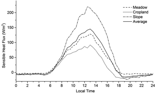
In , the turbulent sensible heat flux from the surface to the air has an average of 33.5 W/m2, a maximum of 128.4 W/m2 at 13:00, and a minimum of −6.3 W/m2 at 19:00 at the meadow; an average of 18.1 W/m2, a maximum of 92.0 W/m2 at 13:00, and a minimum of −20.0 W/m2 at 18:30 at the cropland; and an average of 55.8 W/m2, a maximum of 220.6 W/m2 at 12:30, and a minimum of −23.9 W/m2 at 19:30 at the slope. The land–air sensible heat transfer has similar diurnal variation, directed upward at daytime and downward at nighttime at all three sites. The land–air sensible heat transfer is strongest at the slope and weakest at the cropland. Because of the enhanced solar heating at day resulting from the larger incidence angle on the south-facing slope, the canopy surface temperature at the slope site could be higher than those at the meadow and cropland sites. The higher canopy surface temperature, together with the lower air temperature with the higher altitude, formulates the higher land–air temperature contrast and drives the higher sensible heat transfer at the slope site than at the other sites. The three-site averaged sensible heat flux is calculated as 35.8 W/m2, the largest bias at the slope is 20.0 W/m2, and the heterogeneity rate is 56 percent in the observational domain. This result indicates a large impact of the topography and land cover on the land–air sensible heat exchange in this region.
Figure 6. The diurnal variations in sensible heat fluxes at the three observation sites, averaged from June 9 to July 9, 2013
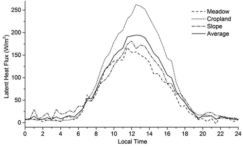
In , the turbulent latent heat flux has an average of 55.5 W/m2, a maximum of 167.0 W/m2 at 11:30, and a minimum of −2.2 W/m2 at 21:30 at the meadow; an average of 83.8 W/m2, a maximum of 262.3 W/m2 at 12:30, and a minimum of 4.0 W/m2 at 4:00 at the cropland; and an average of 64.7 W/m2, a maximum of 182.4 W/m2 at 12:00, and a minimum of 4.3 W/m2 at 3:00 at the slope. The latent heat transfer has a similar diurnal variation, directed upward at all times. The latent heat flux at the cropland is much higher than those at the meadow and slope because of the large water release by crop respiration and evaporation. The three-site averaged latent heat flux is 68.0 W/m2, the largest bias of 15.8 W/m2 is at the cropland, and the heterogeneity rate for latent heat exchange is 23 percent. This result indicates a great impact of land covers, especially vegetation, on the heterogeneity of land–air latent heat exchange.
Figure 7. The diurnal variations in latent heat fluxes at the three observation sites, averaged from June 9 to July 9, 2013
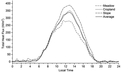
In the total turbulent heat flux has an average of 89.0 W/m2, a maximum of 285.3 W/m2 at 11:30, and a minimum of −7.2 W/m2 at 21:30 at the meadow; an average of 101.9 W/m2, a maximum of 350.5 W/m2 at 13:00, and a minimum of −2.3 W/m2 at 4:00 at the cropland; and an average of 120.5 W/m2, a maximum of 388.0 W/m2 at 13:00, and a minimum of −16.3 W/m2 at 19:30 at the slope. In summary, the total turbulent heat transfer is mainly directed from the surface to the air at all sites, and the total heat flux decreases from the slope sites to the cropland and meadow sites. This result is consistent with the net radiation received at those sites. The three-site averaged total heat flux is calculated as 103.8 W/m2, the largest bias at the slope is 16.7 W/m2, and the heterogeneity rate for total heat exchange is 16 percent, close to the rate for net radiation.
Figure 8. The diurnal variations in total heat fluxes at the three observation sites, averaged from June 9 to July 9, 2013
To identify the heterogeneity in the feature of the land–air heat exchange, the Bowen ratio is calculated by the division of the average sensible heat flux to the latent heat flux, as 0.60 at the meadow, 0.22 at the cropland, and 0.86 at the slope. The Bowen ratio is smaller than 1.0 at all the sites, indicating the domination of latent heat transfer in the land–air heat-exchange process. The three-site averaged Bowen ratio is obtained as 0.53, the largest bias is 0.33 at the slope, and the heterogeneity rate for the Bowen ratio is calculated as 62 percent, indicating the great impact of topography and land cover on the land–air heat exchange in the Eastern Himalayas.
In summary, the heterogeneities of the land–air heat transfers and Bowen ratio are listed in . Compared with , the heterogeneity of total heat exchange (16%) in the domain is close to that of the net radiation flux (17%) because the total heat exchange is mainly in balance with the energy income of the surface, the net radiation flux. In principle, the land–air heat exchange is driven by the contrast in physical properties between surface and air with the turbulent transfer ability, which is dependent on dynamic and thermal features, such as surface roughness and air stability. Therefore, the heat-transfer components, the sensible and latent transfers, and the related Bowen ratio show much larger heterogeneity than the total heat transfer. Furthermore, the temperature contrast-dependent sensible heat transfer has much larger heterogeneity than the water contrast-dependent latent heat transfer. The heterogeneity in the land–air heat exchange (), especially in the transfer components and Bowen ratio, is much higher than in the atmospheric conditions (). This great heterogeneity could introduce very large uncertainty, up to 62 percent, in our understanding of the land–air heat exchange in the complex surface of the Tibetan mountains.
Table 2. Heterogeneity in the land–air heat transfer in southeastern Tibet
Conclusions
Based on this analysis and discussion on heterogeneity in the atmospheric conditions and land–air heat exchange in the Eastern Himalayas, the following conclusions can be drawn:
Obvious heterogeneities in atmospheric conditions, including radiation, temperature, humidity, and wind, are detected in the Eastern Himalayan mountains, with large altitude gradients and diverse land covers. These heterogeneities would introduce large uncertainties of up to 33.3 percent into our knowledge of the local weather and climate in this mountain region.
The large heterogeneities in the land–air heat exchange, especially the heat-exchange components and Bowen ratio, are revealed in the Eastern Himalayas. These heterogeneities would bias our understanding of total surface heating up to 16 percent and of heating properties up to 62 percent in this region.
The large surface heterogeneity, including in topography and surface covers, is the driving force for the small-scale heterogeneity in the local atmosphere and land–air heat exchange. Therefore, attention should be given to the uncertainties introduced by the small-scale heterogeneity for any weather and climate studies on a complex terrain, such as the Eastern Himalayas.
The heterogeneity rate defined and applied in this study could be a useful measure to generally identify the uncertainties in our understanding of the local atmosphere and land–air heat exchange.
Disclosure statement
No potential conflict of interest was reported by the authors.
Additional information
Funding
References
- Bai, J., H. Zou, A. Li, S. Ma, J. Jia, P. Li, W. Wang, and C. Huo. 2007. The characteristics and analysis of solar radiation and atmosphere at the north slope of the Mount Zhumulangma. Plateau Meteorology 36 (6):1–12.
- Bian, L., Z. Gao, Q. Xu, L. Lu, and Y. Cheng. 2002. Measurements of turbulence transfer in the near-surface layer over the southeastern Tibetan Plateau. Boundary-Layer Meteorology 102:281–300. doi:https://doi.org/10.1023/A:1013177629245.
- Brook, R. R. 1978. The influence of water vapor fluctuations on turbulent fluxes. Boundary-Layer Meteorology 15:481–87. doi:https://doi.org/10.1007/BF00120609.
- Ding, Y. 2007. The variability of Asian summer monsoon. Journal of the Meteorological Society of Japan 85B:21–54. doi:https://doi.org/10.2151/jmsj.85B.21.
- Egger, J., S. Bajrachaya, U. Egger, R. Heinrich, J. Reuder, P. Shayka, H. Wendt, and V. Wirth. 2000. Diurnal winds in the Himalayan Kali Gandaki Valley. Part I: Observations. Monthly Weather Review 128:1106–22. doi:https://doi.org/10.1175/1520-0493(2000)128<1106:DWITHK>2.0.CO;2.
- Gao, Z., J. Wang, Y. Ma, J. Kim, T. Choi, H. Lee, J. Asanuma, and Z. Su. 2000. Calculation of near surface layer turbulent transport and analysis of surface thermal equilibrium features in Nagqu of Tibet. Physics and Chemistry of the Earth Part B 25 (2):135–39. doi:https://doi.org/10.1016/S1464-1909(99)00124-0.
- Goswami, B. N., R. S. AjayaMohan, P. K. Xavier, and D. Sengupta. 2003. Clustering of low pressure systems during the Indian summer monsoon by intraseasonal oscillations. Geophysical Research Letters 30 (8). doi: https://doi.org/10.1029/2002GL016734.
- He, H., J. McGinnis, Z. Song, and M. Yanai. 1987. Onset of the Asian summer monsoon in 1979 and the effect of the Tibetan Plateau. Monthly Weather Review 115:1966–95. doi:https://doi.org/10.1175/1520-0493.
- Hsu, -H.-H., and X. Liu. 2003. Relationship between the Tibetan Plateau heating and East Asian summer monsoon rainfall. Geophysical Research Letters 30 (20):2066. doi:https://doi.org/10.1029/2003GL017909.
- Huang, R. 1985. The dynamic effect of the Tibetan Plateau and the Rocky mountains on the formation of stationary planetary waves in the Northern Hemisphere in summer. Chinese Journal of Atmospheric Sciences 9 (3):243–50.
- Hunt, J. C. R. 1973. A theory of turbulent flow round two-dimensional bluff bodies. Journal of Fluid Mechanics 61:625–706. doi:https://doi.org/10.1017/S0022112073000893.
- Hunt, J. C. R., K. J. Richards, and W. M. Brighton. 1988. Stably stratified shear flow over low hills. Quarterly Journal of the Royal Meteorological Society 114:859–86. doi:https://doi.org/10.1002/(ISSN)1477-870X.
- Li, J., Z. Hong, W. Luo, A. Li, and Y. Zhao. 1999. A study of surface fluxes in Gerze area, Qinghai-Xizang Plateau. Chinese Journal of Atmospheric Sciences 23 (2):142–51.
- Liao, K. 1990. The Atlas of the Tibetan Plateau. Beijing: Science Press.
- Liao, K. 1999. National General Atlas of P. R. China sheet 5, scale 1:10,000,000. Beijing: SinoMaps Press.
- Ludecke, C., and M. Kuhle. 1991. Comparison of meteorological observations at Mt. Everest and K 2: Examples of the 1984 and 1986 expedition. Meteorology and Atmospheric Physics 47:55–60. doi:https://doi.org/10.1007/BF01025827.
- Ma, S. P., L. B. Zhou, H. Zou, M. Zhang, and P. Li. 2013. Role of snow/ice cover in the formation of local Himalayan circulation. Meteorology and Atmospheric Physics 120:45–51. doi:https://doi.org/10.1007/s00703-013-0236–x.
- Riehl, H., G. Greenhut, and B. R. Bean. 1978. Energy transfer in the tropical subcloud layer measured with DC-6 aircraft during GATE. Tellus 30:524–36. doi:https://doi.org/10.3402/tellusa.v30i6.10397.
- Stull, R. B. 1988. An introduction to boundary layer meteorology. Dordrecht, Netherlands: Kluwer Academic.
- Taylor, P. A., P. J. Mason, and E. F. Bradley. 1987. Boundary-layer flow over low hills (a review). Boundary-Layer Meteorology 39:107–32. doi:https://doi.org/10.1007/BF00121870.
- Wang, B., Q. Bao, B. Hoskins, G. Wu, and Y. Liu. 2008. Tibetan Plateau warming and precipitation changes in East Asia. Geophysical Research Letters 35:L14702. doi:https://doi.org/10.1029/2008GL034330.
- Webb, E. K., G. I. Pearman, and R. Leuning. 1980. Correction of flux measurements for density effects due to heat and water vapor transfer. Quarterly Journal of the Royal Meteorological Society 106:85–100. doi:https://doi.org/10.1002/qj.49710644707.
- Webster, P. J., V. O. Magaña, T. N. Palmer, J. Shukla, R. A. Tomas, M. Yanai, and T. Yasunari. 1998. Monsoons: Processes, predictability, and the prospects for prediction. Journal of Geophysical Research 103 (C7):14451–510. doi:https://doi.org/10.1029/97JC02719.
- Wu, G., Y. Liu, B. He, Q. Bao, A. Duan, and F. Jin. 2012. Thermal controls on the Asian summer monsoon. Nature Scientific Reports 2:404. doi:https://doi.org/10.1038/srep00404.
- Wu, G. X., and Y. S. Zhang. 1998. Tibetan Plateau forcing and the timing of the monsoon onset over South Asia and the South China Sea. Monthly Weather Review 126:913–27. doi:https://doi.org/10.1175/1520-0493(1998)126<0913:TPFATT>2.0.CO;2.
- Xu, H., H. Zou, P. Li, and B. Tan. 2014. Vertical structure and variation of wind field over Nyingchi airport Southeast Tibet. Plateau Meteorology 33 (2):355–66. doi:https://doi.org/10.7522/j.issn.1000-0534.2013.00009.
- Yanai, M., C. Li, and Z. Song. 1992. Seasonal heating of Tibetan Plateau and its effects on the evolution of the Asian summer monsoon. Journal of the Meteorological Society of Japan 70:319–51. doi:https://doi.org/10.2151/jmsj1965.70.1B_319.
- Ye, D., and D. Gao. 1980. The heating effect of Mt. Everest on the atmosphere in spring and summer. In The Reports of Scientific Expedition to Mt. Everest, 1975, Meteorology and Environment, ed. by the Chinese Academy of Sciences Comprehensive Scientific Expedition of Qinghai Tibet Plateau, 157–168. Beijing: Science Press.
- Ye, D., and Y. Gao. 1979. Meteorology of the Qinghai-Xizang Plateau. Beijing: Science Press
- Zhou, L., H. Zou, S. Ma, F. Li, J. Zhu, P. Li, and Y. Zhang. 2015. The observed impacts of South Asian summer monsoon on the local atmosphere and the near-surface turbulent heat exchange over the Southeast Tibet. Journal of Geophysical Research - D: Atmospheres 120 (22):11509–18. doi:https://doi.org/10.1002/2014JD022928.
- Zhou, L. B., H. Zou, S. Ma, and P. Li. 2008. Study on impact of the South Asian summer monsoon on the down-valley wind on the north slope of Mt. Everest. Geophysical Research Letters 35:L14811. doi:https://doi.org/10.1029/2008GL034151.
- Zhou, L. B., H. Zou, S. Ma, and P. Li. 2012. Observed impact of the South Asian summer monsoon on the local meteorology in the Himalayas. Acta Meteorologica Sinica 26 (2):205–15. doi:https://doi.org/10.1007/s13351-012-0206-0.
- Zhou, L. B., H. Zou, S. Ma, and P. Li. 2013b. The Tibetan ozone low and its long-term variation during 1979–2010. Acta Meteorologica Sinica 27 (1):75–86. doi:https://doi.org/10.1007/s13351-013-0108-9.
- Zhou, L. B., H. Zou, S. P. Ma, P. Li, J. H. Zhu, and C. P. Huo. 2011. Vertical air mass exchange driven by the local circulation on the northern slope of Mount Everest. Advances in Atmospheric Sciences 28 (1):217–22. doi:https://doi.org/10.1007/s00376-010-9231-z.
- Zhou, L. B., J. Zhu, H. Zou, S. Ma, P. Li, Y. Zhang, and C. Huo. 2013a. Atmospheric moisture distribution and transport over the Tibetan Plateau and the impacts of the South Asian summer monsoon. Acta Meteorologica Sinica 27 (6):819–31. doi:https://doi.org/10.1007/s13351-013-0603-z.
- Zhou, X., P. Zhao, L. Chen, and W. Li. 2009. Impacts of thermodynamic processes over the Tibetan Plateau on the Northern Hemispheric climate. Science in China Series D: Earth Sciences 52 (11):1679–93. doi:https://doi.org/10.1007/s11430-009-0194-9.
- Zou, H. 1996. Seasonal variation and trends of TOMS ozone over Tibet. Geophysical Research Letters 23 (9):1029–32. doi:https://doi.org/10.1029/96GL00767.
- Zou, H., L. B. Zhou, S. Ma, P. Li, W. Wang, A. Li, J. Jia, and D. Gao. 2008. Local wind system in the Rongbuk Valley on the northern slope of Mt. Everest. Geophysical Research Letters 35:L13813. doi:https://doi.org/10.1029/2008GL033466.
- Zou, H., P. Li, S. P. Ma, L. B. Zhou, and J. H. Zhu. 2012. The local atmosphere and the turbulent heat transfer in the eastern Himalayas. Advances in Atmospheric Sciences 29 (3):435–40. doi:https://doi.org/10.1007/s00376-011-0233-2.
- Zou, H., S. Ma, L. B. Zhou, P. Li, and A. Li. 2009. Measured turbulent heat transfer on the northern slope of Mt. Everest and its relation to the South Asian summer monsoon. Geophysical Research Letters 36:L09810. doi:https://doi.org/10.1029/2008GL036984.
- Zou, H., and Y. Gao. 1997. Vertical ozone profile over Tibet using SAGE I and II data. Advances in Atmospheric Sciences 14 (4):505–12. doi:https://doi.org/10.1007/s00376-997-0068-z.