
ABSTRACT
In high alpine environments, glacial shrinkage and permafrost warming due to climate change have significant consequences on mountaineering routes. Few research projects have studied the relationship between climate change and mountaineering; this study attempts to characterize and explain the evolution over the past 40 years of the routes described in The Mont Blanc Massif: The 100 Finest Routes, Gaston Rébuffat’s emblematic guidebook, published in 1973.The main elements studied were the geomorphic and cryospheric changes at work and their impacts on the itinerary’s climbing parameters, determining the manner and possibility for an itinerary to be climbed. Thirty-one interviews, and comparison with other guidebooks, led to the identification of 25 geomorphic and cryospheric changes related to climate change that are affecting mountaineering itineraries. On average, an itinerary has been affected by nine changes. Among the 95 itineraries studied, 93 have been affected by the effects of climate change – 26 of them have been greatly affected; and three no longer exist. Moreover, periods during which these itineraries can be climbed in good conditions in summer have tended to become less predictable and periods of optimal conditions have shifted toward spring and fall, because the itineraries have become more dangerous and technically more challenging.
Introduction
Climate change led to a temperature increase of 2°C in the Alps between the end of the nineteenth century and the beginning of the twenty-first (Auer et al. Citation2007), with a strong acceleration in warming since the 1990s (IPCC, Citation2014). In this context, and due to being very sensitive to climate variations, high alpine environments have undergone major change. The total surface area of alpine glaciers decreased by half between 1900 and 2012 (Huss Citation2012; Vincent et al. Citation2017), while rock faces experienced an increase in the frequency and volume of rockfall (Geertsema et al. Citation2006; Ravanel and Deline Citation2011; Ravanel et al. Citation2013, Citation2017). These changes raise the question of what the effects might be on recreational mountain activities, and especially on mountaineering. Mountaineers climbing during the summer months are undeniably noticing important changes to the environment to which they must adapt by modifying their techniques. Although awareness of this issue dates back to the 2000s, only a few studies have been conducted to confirm it—such as Behm, Raffeiner, and Schöner (Citation2006), Ritter, Fiebig, and Muhar (Citation2012), Bourdeau (Citation2014), Temme (Citation2015), and Mourey and Ravanel (Citation2017). As such, the evolution of mountaineering itineraries due to climate change remains poorly documented. This article aims to describe and explain the evolution—over nearly half a century—of mountaineering itineraries in the Mont Blanc massif (MBM), the birthplace of mountaineering and still a major mountaineering destination (Modica Citation2015).
However, it is impossible to document all mountaineering itineraries as several thousand have been climbed in the MBM. The 1975 Vallot guidebook—The Mont Blanc Massif, Aiguille Verte–Triolet–Dolent–Argentière–Trient (Devies and Menry Citation1975)—which lists the routes in each glacial basin with a detailed description, includes 747 itineraries. Hence, our study focuses on the itineraries in Gaston Rébuffat’s famous guidebook, The Mont Blanc Massif: The 100 Finest Routes. Using recent guidebooks and interviews, the itineraries described by Rébuffat in 1973 were compared with their current state. First, the geomorphic and cryospheric changes that have affected the area were identified; then, for each itinerary, the specific changes that have affected it were established and also the degree to which these changes have changed the climbing technical level and danger. The evolution of the manner in which mountaineers tackle these routes due to the effects of climate change will then be discussed, along with the consequences for the popularity of mountaineering.
Study site
The MBM the birthplace of mountaineering, which is being strongly affected by climate change
Mountaineering originally developed in the western Alps, and especially in the MBM, at the end of the eighteenth century (Hoibian Citation2008). Since then, it has evolved considerably through technical (Duez Citation2009), cultural and ideological changes (Hoibian and Defrance Citation2002; Bourdeau Citation2003). The “Golden Age” of mountaineering, whose 150th anniversary was celebrated in 2015, is considered to start in 1854 and end in 1865 with the first ascent of the Matterhorn (Switzerland). It was marked by a series of important first ascents, most notably those made by Edward Whymper and his guides in the MBM. In 2018 Chamonix (France) and Courmayeur (Italy) applied for mountaineering to be included on UNESCO’s Intangible Cultural Heritage Lists. Over the past 200 years, the evolution of mountaineering has been mainly due to socio-cultural reasons (Hoibian and Defrance Citation2002; Bourdeau Citation2003). However, the current changes to the high mountain environment due to climate change is challenging accepted mountaineering practices.
The MBM () is located in the north-western Alps between Switzerland, Italy and France, and covers 550 km2. About 30% of its surface is covered with ice (Gardent et al. Citation2014), with some 100 glaciers – including the Mer de Glace, the largest glacier in the French Alps, with an area of 30 km2. A dozen peaks exceed the altitude of 4,000 m a.s.l., including Mont Blanc, the highest summit of the Alps at 4,809 m a.s.l.
Figure 1. Location of the Mont Blanc massif, the itineraries studied and their level of evolution.
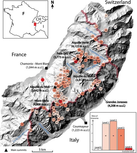
The MBM presents a cross-range asymmetry. Six of the largest glaciers of the massif are located on its north-western aspect, where slopes are gentler than on its very steep south-eastern aspect, which is characterized by small glaciers bounded by high subvertical rock walls. This asymmetry implies different climatic contexts. In Chamonix (1,044 m a.s.l.), the mean annual air temperature (MAAT) is +7.2°C, while in Courmayeur (1,223 m a.s.l.), it is 10.4°C. At the Aiguille du Midi (3,842 m a.s.l.), the MAAT is −8.2°C (reference period: 2008–2010, Météo-France data). In Chamonix, MAAT increased by 1.7°C between 1934 and 2009. It is important to note that this warming mainly affects winter temperatures (Durand et al. Citation2009); these increased by 2.8°C compared to summer temperature, which increased by 1.5°C (Météo-France data). Moreover, MAAT increased four times faster over the period 1970–2009 than during the period 1934–1970. The MAAT also increased at high elevations: above 4,000 m a.s.l., it increased by 1.4°C between 1990 and 2014 (Gilbert and Vincent Citation2013). Since 1990, the MBM has experienced seven summer heat waves (in 1994, 2003, 2006, 2009, 2015, 2017 and 2018). In France, summer 2018 was the second hottest summer since 1900 (2003 was hotter). In Chamonix, the average annual precipitation is 1,288 mm. In Courmayeur, it is 854 mm. At 3,500 m a.s.l., precipitation is three times higher than in the town of Chamonix (Vincent Citation2002). Since the end of the Little Ice Age (LIA), precipitation levels have experienced little change; however, there has been a clear decrease in snowfall days relative to total precipitation days (Serquet et al. Citation2011) and there is more frequent and intense melting (Klein et al. Citation2016). Consequently, in the Swiss Alps between 1,139 and 2,540 m a.s.l., snow cover duration shortened by 8.9 days/decades−1 during the period 1970–2015, with a snow season starting 12 days later and ending 26 days earlier than in 1970 (Klein et al. Citation2016). While these changes in snow cover are elevation dependent, and less pronounced at higher altitudes (Durand et al. Citation2009), snow quantity at high altitude is also decreasing.
With higher and faster warming at high altitudes than the global average (Beniston Citation2005; Auer et al. Citation2007), climate change is causing substantial change to high mountain environments. In the MBM, the glacial surface area decreased by 24% between the end the LIA and 2008 (Gardent et al. Citation2014), with a considerable increase in the acceleration of melting since the 1990s (Huss Citation2012; Vincent et al. Citation2017). Mean glacier mass balance in the European Alps was −0.31 ± 0.04 m w.e.a−1 during the period 1900–2011 and −1 m w.e.a−1 during the first decade of the 2000s (Huss Citation2012), which illustrates the acceleration of glacial shrinkage. In the MBM, the region-wide mean mass balance was −1.04 ± 0.23 m w.e.a−1 between 2003 and 2012; the Argentière glacier mean mass balance over the same period was −1.46 ± 0.4 m w.e.a−1 (Berthier et al. Citation2014). The loss of ice thickness is also significant. At 1,900 m a.s.l., between 1994 and 2013, the Argentière glacier (MBM, France) has lost 80 m of ice depth. On the Mer de Glace (MBM, France), the rate of glacial thickness loss increased from 1 m.a−1 (1979–1994) to more than 4 m.a−1 (2000–2008; Berthier and Vincent Citation2012). The Mer de Glace loss in thickness was up to 60 m at the front (1,500 m a.s.l.) during the period 1979–2003 (Berthier Citation2005). At the same time, glacier fronts retreated dramatically: 366 m between 1994 and 2007 for the Mer de Glace, with a particularly rapid period of shrinkage of 40 m/y between 1998 and 2005 (Vincent Citation2010). Glacial shrinkage affects high elevations (i.e., above the glacier equilibrium line altitude—ELA—separating the accumulation and ablation zones). Between the 1960s and 2008, the glacier surface areas on the French side of the MBM decreased by 16% at 2,200–2,600 m, 11% at 2,600–3,000 m, 6% at 3,000–3,500 m, and 3% at 3,500–4,000 m a.s.l. (Deline et al. Citation2012). For example, the surface of the Talèfre glacier lowered by 5–10 m between 3,000 and 3,500 m a.s.l. over the period 1979–2003 (Berthier Citation2005). At 3,613 m a.s.l., the Géant glacier surface lowered by 20 m between 1992 and 2012 (Ravanel et al. Citation2013).
Glacial shrinkage coincides with a rise of the ELA of 170 m between 1984 and 2010 in the western Alps (Rabatel et al. Citation2013). Also, combined with a decrease in winter snow accumulation, the snow cover on the glacier surfaces tends to decrease both in area and thickness. As a result, crevasses appear earlier in spring and areas of bare ice increase in summer. The decrease in snow cover on glaciers also results in an increase in the number of open crevasses, while snow bridges may be getting more fragile. The fragility of snow bridges is probably increasing as the average altitude of the 0°C isotherm has risen by 400 m since 1980 (Böhm et al. Citation2010) and the frost frequency has decreased (Pohl et al. Citation2019). The snow pack does not refreeze and consolidate, especially during the night. As such, snow bridges are probably weakening earlier in spring and during heat waves.
In some cases, glacier retreat leads to more frequent serac fall from the hanging fronts of warm and cold-based glaciers (Fischer et al. Citation2006). In the MBM, serac fall mainly occurs during the warmest periods of the year and, on a secular scale, during or at the end of the warmest periods (Deline et al. Citation2012).
Due to glacial shrinkage, paraglacial processes—defined by Ballantyne (Citation2002) as “the nonglacial earth-surface processes, sediment accumulations, landforms, landsystems and landscapes that are directly conditioned by glaciation and deglaciation”—are intensifying. A paraglacial period starts as a direct reaction to deglaciation and ends when all glacial sediments have been removed or stabilized (Church and Ryder Citation1972; Ballantyne Citation2002). In this study, paraglacial processes refer mainly to the erosion of moraines through rockfall and landslides (McColl Citation2012; Deline et al. Citation2015; Draebing and Eichel Citation2018; Eichel, Draebing, and Meyer Citation2018; Ravanel et al. Citation2018), illustrated by the gullying of the inner flank of lateral moraines due to very steep slopes, up to 80° (Lukas et al. Citation2012).
At the same time, permafrost—ground that remains permanently at or below 0°C for at least two consecutive years (Dobinski Citation2011)—tends to warm and degrade (Haeberli and Gruber Citation2009). Even if all rockfalls cannot be attributed to permafrost warming, as it is a natural erosion process in high mountain environments (Allen, Cox, and Owens Citation2011; Collins and Stock Citation2016; D’Amato et al. Citation2016), its degradation results in more frequent and voluminous slope instabilities (rockfalls, rock slides) (Harris, Davies, and Etzelmüller Citation2001; Harris et al. Citation2009; Ravanel and Deline Citation2011; Ravanel et al. Citation2013; Ravanel, Magnin, and Deline Citation2017). In the MBM, more than 850 rockfalls (V > 100 m3) occurred between 2007 and 2018 (Ravanel and Deline Citation2015). Permafrost is continuously present above 3,000 m a.s.l., on average, on north faces and above 3,600 m a.s.l. on south faces (Magnin et al. Citation2015).
The change in the high mountain environment raises the question of how mountaineering itineraries have been affected and what effect this has had on their popularity.
The MBM: The 100 Finest Routes by G. Rébuffat (Citation1973), as reference sample
G. Rébuffat’s guidebook—The Mont Blanc Massif: The 100 Finest Routes—has for several decades been a major source of information for mountaineers. It was the first guidebook to offer a selection of routes based on their quality, unlike guidebooks of the same period – such as the Vallot series – that usually drew up the most exhaustive list of all the routes of a region. This is why it quickly became popular for any mountaineer visiting the MBM. In addition, it arranges routes by increasing difficulty (from facile [easy] to extrêmement difficile [extremely difficult]) and/or commitment (the potential seriousness of a fall), and so can be used as a reference for progression. All types of routes are covered—rock, snow, ice and mixed (snow/ice and rock)—and they have been chosen from throughout the massif (), making it a relevant and representative selection of all mountaineering itineraries in the MBM. For each itinerary, an introductory text describes the itinerary, the first ascent, the elevation gains, the level of technical difficulty, the time required, the necessary equipment, the starting point and the route to follow.
Not all the itineraries presented by G. Rébuffat were taken into consideration in this study: itineraries 1 and 3–8 were ruled out because they are located outside the MBM (in the Aiguilles Rouges massif, Valais Alps and Aosta Valley). On the other hand, several itineraries are presented together in the guidebook, as they can by climbed the same day or on the same trip into the mountains; but these have been treated separately in this study. Itinerary 17 is an example: Rébuffat recommends combining the normal route on Mont Blanc du Tacul (4,248 m a.s.l.) with the Cosmiques ridge on the Aiguille du Midi (3,842 m a.s.l.) in a single day. Altogether, 95 itineraries were analyzed. In some cases, several descents are possible; only the most classic were chosen.
Methodology
Our study is structured according to two main data collection methodologies. First, semi-structured interviews were carried out with alpine guides, including instructors at the National School of Skiing and Mountaineering (ENSA), hut keepers, employees in charge of the management of the trails, first ascensionists and guidebook editors. In total, 31 people were interviewed. These people all have a good knowledge of mountaineering itineraries and 19 of them have been active in the MBM since the 1980s, but only four senior alpine guides who have frequented the range since the 1970s were interviewed. The two main questions were: (1) What are the ongoing long-term changes on the itineraries (since the 1970s)? and (2) How have these itineraries changed with regards to technical difficulty, objective dangers, and optimal periods for making an ascent? The interviewees were only asked to report long-term changes of the itineraries. Attribution of the climate-related changes was carried out by two researchers, both very familiar with the MBM, and their results were compared afterwards. In some cases, to confirm the information collected during the interviews, the descriptions of itineraries from Rébuffat’s guidebook were compared with those from recent guidebooks (Damilano Citation2005, Citation2006; Piola Citation2006; Laroche and Lelong Citation2010; Batoux Citation2012; Pusch, Dumler, and Burkhardt Citation2014).
Two sets of interviews were conducted in fall 2017. The first set led to the identification of the climate-related changes that have affected the itineraries (). Some of these have been the subject of scientific research, which has enabled us to confirm their existence and describe them more accurately. A second set of interviews was conducted in order to list the geomorphic and cryospheric changes affecting each of the 95 itineraries studied. At least 10 itineraries were considered per interview, which thus tended to be relatively long (up to 2–3 hours). The studied itineraries varied from one interview to another, depending on the memories of the interviewees. In the end, each of the 95 itineraries was studied during at least two different interviews. The database was formalized as a table, cross-referencing each of the 95 itineraries with the 25 geomorphic and cryospheric changes. This was completed during the interviews. The results are presented in . However, one of the limits of this method of data formalization is that the location and the intensity/characteristics of each of the changes identified were not recorded. Each itinerary was divided into three parts: (i) the approach, which begins in the valley or at the top of a cable car and ends either at the foot of the rock wall to be climbed or at the bergschrund; (ii) the route and its continuation to the summit; and (iii) the descent, which begins at the summit and ends in the valley or at the top of a lift.
Table 1. Climate-related geomorphic and cryospheric changes affecting mountaineering itineraries and their climbing parameters.
During this second set of interviews, a 5-level scale was developed to evaluate the evolution of the climbing parameters of each itinerary. The climbing parameters considered are: itinerary type (ice, snow, mixed or rock), technical difficulty, level of exposure to objective dangers, and any changes to the optimal period for making an ascent (i.e., when the number/intensity of the changes affecting it are the lowest).
Level 0. The itinerary and the parameters determining the way it is climbed have not changed.
Level 1. The itinerary and its climbing parameters have slightly evolved. Only a short section of the itinerary is affected by geomorphic and cryospheric changes, and this does not result in a significant increase in objective dangers and/or in technical difficulty.
Level 2. The itinerary and its climbing parameters have moderately evolved. The optimal periods for making an ascent have become rare/unpredictable in summer and shifted toward spring and sometimes fall. Objective dangers and technical difficulty are increasing and mountaineers therefore have to adapt their technique.
Level 3. The itinerary and its climbing parameters have greatly evolved. Generally, the itinerary can no longer be climbed in summer. Objective dangers and technical difficulty have greatly increased due to the number and intensity of the geomorphic changes affecting it. Mountaineers have had to fundamentally change the manner in which they climb the itinerary.
Level 4. The itinerary has completely disappeared. The itinerary can no longer be climbed.
The identification of the changes affecting a mountaineering itinerary varied greatly from one person to another depending on the climbing circumstances encountered during the ascent (i.e., the occurrence/absence and the intensity of the changes previously identified), the technical level and number of their clients and their personal perception. The changes identified were not always the same, nor assessed to the same degree. As an example, at the end of the summer season when the glacier surface is icy, any increase in steepness is more significant and easier to identify compared to the beginning of the season when the glacier surface is still covered with snow. Moreover, the interviewees tended to underestimate the number of changes affecting an itinerary. Indeed, it seems that individuals usually notice only the changes that are relevant when they are making an ascent, without necessarily taking into account the season and high mountain climate-related evolution. It was the interviewers’ role to encourage interviewees to identify only long-term changes rather than focusing on their last ascent. For this reason, a great number of interviews were conducted in order to validate the data collected.
Results
Geomorphic and cryospheric changes affecting mountaineering itineraries and the manner in which they are climbed
Twenty-five geomorphic and cryospheric changes were identified (). These result from glacial shrinkage, a reduction of ice-snow cover, changes in the structure of snow ridges, and permafrost warming. For each geomorphic change, its impact on the climbing parameters was identified (): increase in objective dangers, technical difficulty and commitment, lengthening of the itinerary and any increase in the effort required to climb it.
All the types of changes that have affected each route between the 1970s and today were listed. On average, an itinerary has been affected by nine geomorphic changes. The appearance of bedrock (85 itineraries affected), wider crevasses and bergschrunds (78) and steeper glaciers (73) are the three most commonly observed changes. They cause an increase in dangerousness and technical difficulty. The alpine guides interviewed all had to deal with thinner and weaker snow bridges, while crevasses that were never or rarely observed, now appear more often.
Finally, regarding the evolution scale used to evaluate changes to the itineraries studied from a mountaineering point of view (), 2 had not evolved (level 0), 30 had slightly evolved (level 1), 34 had moderately evolved (level 2), 26 had greatly evolved (level 3), and three had disappeared (level 4). Four examples are described below to better illustrate those evolutions and the implications for mountaineering. Moreover, there is a direct correlation between the number of geomorphic changes affecting an itinerary and its level of evolution. On average, for level 1, 7.4 changes were affecting the itineraries, 10 for level 2, 11.5 for level 3 and 12.5 for level 4. It is also important to note that during the summer of 2018, the evolution levels of three itineraries changed: from 1 to 3 (Cosmiques ridge—itinerary 17), 1 to 4 (Lépiney route—itinerary 37) and 1 to 2 (Rébuffat-Bacquet route—itinerary 55). The geomorphic changes responsible for those three evolutions have been identified thanks to a network of observers (mainly alpine guides and hut keepers) developed to study geomorphic changes in the MBM (Ravanel and Deline Citation2013).
Different patterns of evolution depending on the nature of the routes (rock, snow, ice or mixed)
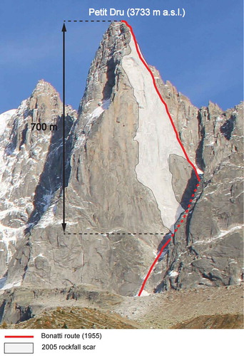
Disappearance of rock route because of massive rockfall: the example of the Petit Dru (3,733 m a.s.l) west face
The Bonatti route on the Petit Dru west face (itinerary 92) was an emblematic rock climb first ascended in 1955 by the well-known Italian mountaineer Walter Bonatti. However, most of the route disappeared after a 700 m-high pillar collapsed in 2005 (; Ravanel and Deline Citation2008). This route has a level 4 evolution.
Snow and mixed route which can no longer be climbed in summer because of ice/snow cover melting early: the example of the Whymper couloir on the Aiguille Verte (4,122 m a.s.l.)
Figure 2. The Petit Dru West face, October 2017. A major part of the route has disappeared because of a rock collapse in 2005 and a further rockfall in 2011 (292,000 m3).
The Whymper couloir (itinerary 41) is the original route used by Edward Whymper for the first ascent of the Aiguille Verte (4,122 m a.s.l.) in 1865. It is still a classic and emblematic route.
In 1973, Rébuffat classified this itinerary as a snow climb. Today, the ice/snow cover necessary for an ascent of the couloir has been very significantly reduced (). Indeed, it completely melts out early in summer and fractured bedrock appears. This creates circumstances where rock fall is frequent. In addition, the bergschrund at the bottom of the couloir becomes very wide and difficult to cross. Rockfall is observed frequently (oral communication, C. Lelièvre, keeper of the Couvercle hut) and a 22,000 m3 rockfall occurred on the right bank of the couloir in August 2015 (Ravanel, Magnin, and Deline Citation2017; ). These environmental changes have led to an increase in the technical difficulty and inherent danger of the route and it is now possible to climb it only very early in summer. The level of evolution applied to this itinerary is 3.
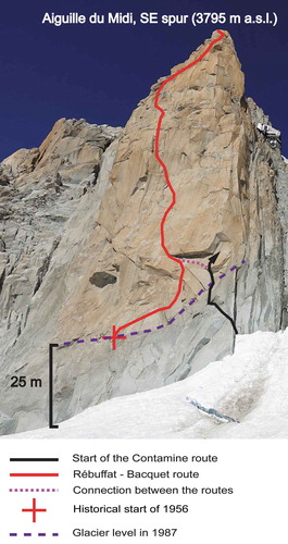
Rock routes whose approach has been affected: the examples of the Aiguille du Midi (3,842 m a.s.l.) south face and the Aiguille du Moine (3,412 m a.s.l.) east face
The Rébuffat-Bacquet route (itinerary 55), climbed in 1956 on the south face of the Aiguille du Midi, is a classic rock climb that sees a lot of traffic in summer. Apart from a small rockfall, it has not yet been directly affected by climate change, but the approach to the original starting-point of the route has become more difficult because of two main factors. First, the east ridge of the Aiguille du Midi that leads to the bottom of the face is becoming narrower. It is orientated west–east, meaning that melting is much more important on its south side than on its north side. This makes it steeper, and it tends to become icy earlier in summer. Crevasses also now appear. Secondly, because the Géant glacier at the foot of the face has lost over 25 m in depth over the past 30 years, the route’s historic starting-point is now difficult to reach (). Climbers now have to follow the start of the Contamine route, which is technically more difficult (graded F6b instead of F6a; see Hagenmuller, Marsigny, and Pallandre Citation2016) than any other pitches on the Rébuffat-Bacquet route. These environmental changes have led to an increase in the technical difficulty and commitment needed to reach the start of the route. The level of evolution applied to this itinerary is 2. Because the surface of the Géant glacier lowered greatly during the 2018 heat wave, the route was not accessible at the end of the summer period. A very difficult climbing section has appeared.
Figure 3. The Whymper couloir on the Aiguille Verte (4,122 m a.s.l.) south face. The route is marked in red. A: situation at the end of the 1960s (picture from the guidebook). B: situation at the end of August 2017 (photo C. Lelièvre). The ice/snow cover in the couloir has undergone a very significant reduction, which has exposed fractured bedrock, leading to frequent rockfalls (orange arrows). The orange star indicates the point where a 22,000 m3 rockfall released in 2015. The red triangles indicate similar features.
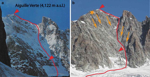
Figure 4. Aiguille du Midi south face, September 2018. The original start to the Rébuffat-Bacquet route (1956) is no longer accessible directly. The lower part of another route must be climbed to join it.
This situation is identical for the majority of rock routes but the increase in difficulty varies depending on the extent of the ice thickness loss and the nature of the terrain exposed. In some cases, the route may lose its intrinsic logic and aesthetics if sections of climbing appear which are much more difficult than the rest of the route. This is the case for the Labrunie-Contamine route (itinerary 51) on the Aiguille du Moine (3,412 m a.s.l.) east face. A 15 m-high section of F6c climbing is now exposed at the start of the route because of the lowered surface of the Talèfre glacier. The rest of the route is graded F6a maximum. This short, difficult section has made the route less attractive, and it is now climbed less frequently than before. The level of evolution applied to this itinerary is 2.
Rock route whose descent is more difficult and dangerous because of glacial shrinkage: the example of the Aiguille de l’M (2,844 m a.s.l.).
The Aiguille de l’M north ridge (itinerary 18) is a very popular rock route. The approach and the route are not affected by geomorphic or cryospheric changes, notably because of its relatively low altitude. However, the way down follows a south-facing couloir to reach the Nantillon Glacier, at 2,500 m a.s.l. Because of the lowering of the glacier surface, the couloir is becoming steeper and very exposed to rockfall coming from the lateral moraine of the glacier. In order to reduce the danger and the technical difficulty, abseils and ladders have been installed in the couloir. Therefore, the itinerary can be climbed all summer and the descent is now less technically difficult. The level of evolution applied to this itinerary is 1.
Discussion
The degree and type of evolution to an itinerary depends on the nature of the terrain
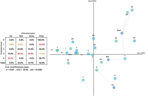
In general, snow, ice and mixed itineraries have been more affected by climate change, with a 2.4 average level of evolution, than rock routes with a 1.6 average level of evolution. This finding is confirmed by a Correspondence Factor Analysis (CFA; Volle Citation1997) linking the level of evolution of the itineraries with their type (rocky, snow, ice and mixed), difficulty, and orientation (). Itineraries undergoing level 3 evolution are mainly mixed and snow routes (46.2% and 26.9%, respectively) graded “assez difficile” (quite difficult) or “peu difficile” (not very difficult) and facing north-east. On the other hand, rock routes are statistically underrepresented (11.5%) in this level of evolution. The routes undergoing level 0, 1 and 2 evolutions are mostly rock routes (100%, 82.8% and 54.3%, respectively) for the highest level of difficulty (extrêmement difficile [extremely difficult] and très difficile [very difficult]). Variable aspects are represented. In the 0 level of evolution, ice routes are statistically underrepresented (0%). We can conclude that rock routes are less affected by the effects of climate change than snow, ice and mixed routes.
Figure 5. Cross-tabulation and graphical representation (CFA type) of the relationships between the level of evolution of a route for mountaineering purposes and its nature (rock, snow, ice and mixed), difficulty and aspect. The closer the circles are, the more meaningful their relations are. The statistically strongest relationships are underlined.
Not all the geomorphic changes identified in this work affect the itineraries in the same way. The approaches are mainly affected by wider crevasses and bergschrunds (53/95), paraglacial processes (41/95) and the appearance of new crevassed areas (27/95). The changes mainly affecting the routes are the appearance of smooth slabs or unstable bedrock (77/95) and all changes related to the disappearance of ice/snow cover and the evolution of snow ridges (52/95). Finally, the changes predominantly affecting the descents are a steepening of glaciated slopes (63/95), wider crevasses and bergschrunds (59/95), and paraglacial processes (41/95). There is also a correlation between some changes and the orientation of the routes. For 39 routes located on southern slopes, 23 are affected by processes due to permafrost degradation and 22 by the appearance of smooth slabs or fractured bedrock. On the other hand, changes in serac fall and the appearance of bare ice mainly affect north-facing routes. Other changes, such as the reduction in ice/snow cover, equally affect routes on southern and northern aspects.
Changes in the optimal season for making an ascent as a result of increased levels of difficulty, commitment and objective danger
It is difficult to measure the effects of one or several changes on the climbing parameters of an itinerary. In general, the identified changes imply an increase in technical difficulty, dangerousness and commitment of these itineraries in summer, but seasonality must be addressed.
The evolution of mountaineering itineraries is conditioned on two different time scales. The main time scale addressed in this study is climate related and covers the period from the 1970s to 2018. However, deterioration on mountaineering itineraries’ climbing parameters can be reduced or increased by seasonal factors. Changes are usually less impactful at the beginning of the summer season, when the winter snow pack has not yet completely melted out (even though snow pack in general is decreasing both in quantity and duration), and they increase at the end of the summer season or during heat waves (which are becoming more and more frequent and intense due to climate change) (IPCC [Field C.B., Barros V.R., Dokken D.J., Mach K.J., Mastrandrea M.D., Bilir T.E., Chatterjee M., Ebi K.L., Estrada Y.O., Genova R.C., et al.] Citation2014). Therefore, itineraries when in an optimal period for making an ascent—more and more commonly outside the summer period—are not necessarily any more difficult or dangerous than before. It is for this reason that good and stable periods for mountaineering tend to be more variable in summer and shift toward spring, fall (as temperatures start to drop and new snow falls occur) and even winter, especially for snow, ice and mixed routes. Depending on the nature of the itinerary, much more attention must be paid to the evolution of climbing parameters. According to the interviewees, the summer mountaineering season has shifted by three weeks toward spring compared with the 1980s. This finding confirms the work of Bourdeau (Citation2014) conducted in the Écrins massif.
An itinerary greatly affected by the effects of climate change effects may still be very popular
There is not necessarily a direct link between the level of change of an itinerary and its popularity. A notable example is the “normal” (classic) itinerary to the summit of Mont Blanc (itinerary 24). It has been greatly affected by climate change, with an increase in technical difficulty and especially in dangerousness. Rockfall is increasingly frequent in the Grand Couloir du Goûter and causes a significant number of accidents. Between 1990 and 2017, there were an average of 3.7 deaths and 8.5 injuries per summer on the crossing of the couloir and the climb to the Goûter ridge, mainly due to human error and rockfall (Mourey et al. Citation2018). In addition, large crevasses which are difficult to cross are appearing even at high altitude (above 4,000 m a.s.l.), while the summit ridge is becoming narrower. The descent described by Rébuffat is no longer used in summer, as it has become too crevassed. Even though the level of evolution applied to this itinerary is 3, it is still one of the busiest mountaineering itineraries in the world because of the prestige of climbing the highest summit in the Alps.
On the other hand, some itineraries that have only been slightly affected by climate change are much less popular than in the past. To explain this, other socio-economic factors and the evolution of mountaineering itself must be considered. Today, mountaineers tend to limit their risk-taking and their exposure to objective dangers such as rock and serac fall. Other itineraries are no longer popular because the approach is long and/or the in situ equipment is old (Bourdeau Citation2003). As an example, according to the alpine guides interviewed, the north face of the Aiguille de Bionnassay (4,052 m a.s.l.—itinerary 49) was a classic ascent during the 1980s. Today, it is no longer climbed in summer despite a relatively low level of evolution (2) because of the danger of serac fall. This danger was also present 40 years ago.
In some cases, the evolution of mountaineering itineraries due to the effects of climate change leads to them becoming less popular. This is the case for the traverse of the Dômes de Miage (3,673 m a.s.l. – itinerary 13), a very famous and beautiful snow climb. During the summer of 2015, a crevasse opened on the summit ridge, which itself had become narrower and icier. In addition, a rockfall occurred on the route, making it more technically difficult and exposing it to further rockfall. The ridgeline was no longer being traversed, with climbers choosing to descend by the ascent route. This made the itinerary less aesthetically pleasing and the number of people staying at the Conscrits hut (2,602 m a.s.l.), which gives access to the route, fell by 25% that summer. This situation occurred again in 2016 and 2017, with significant economic consequences for the hut keeper. The Couvercle hut (2,679 m a.s.l.) is facing the same situation, with climbing parameters on most routes deteriorating earlier in the summer season. According to the former two hut keepers, the steady decline in the number of overnight stays (35% over the last 15 years) has been accentuated by the evolution of the mountain itineraries, perhaps concurrently with socio-economic factors.
Is the aesthetic quality of high mountain areas deteriorating?
Climate change–related geomorphic and cryospheric changes result in significant changes to the landscape (Moreau Citation2010). The general drying of high mountain environments leads to the appearance of more and more rocky terrain while glacial surfaces are decreasing. As snow cover on glacier surfaces melts out faster and at higher altitudes, bare ice is appearing, and supraglacial debris cover is increasing (Deline Citation2005; Martin Citation2011) while rock falls form more continuous deposits. All the interviews carried out indicate that high mountain landscapes no longer conform to the classic representation of blue ice and “eternal snow” (Moreau Citation2010; Bourdeau et al., Citation2014). The motivation of some mountaineers to go into the high mountains is thus reduced. “I note that there is less interest to go on glaciers […] that are dirty, with a dull color; they are less attractive in a certain way” (oral comm. B. Pelissier, alpine guide, Oct. 2017).
Limits
Because Rébuffat’s guidebook dates from the 1970s, it does not present any steep, narrow ice climbs. These “concealed and narrow ice couloirs” (Jouty and Odier Citation1999) are seasonal (Faup Citation2003) and were largely developed in later years thanks to improvements in mountaineering equipment. According to the alpine guides interviewed, the formation of ice gullies is becoming increasingly less frequent and often the quality of the ice is lower. During the 2016 and 2017 winters, almost no such ice gullies formed in the MBM. It seems that the main factors explaining the disappearance of these routes are the lack of winter and spring snowfall and the more rapid melting of the ice/snow cover. This phenomenon seems to be very recent and due, to a large extent, to an increase in the frequency of winter warm spells since the beginning of the 2000s.
Another factor limiting our methodology must also be highlighted. Because some itineraries have the same approach and/or descent, some changes have been overrepresented. This is particularly the case for paraglacial processes that affect all the approaches and descents in the Mer de Glace basin (Mourey and Ravanel Citation2017). One way of limiting this bias would have been to consider only the routes themselves, and not the approaches and the descents; but this method would not have given an accurate representation of the difficulties that mountaineers are facing throughout the whole itinerary.
Moreover, it is not possible to objectively compare the grade of the itineraries between the 1970s and today, as the grading system (Cox and Fulsaas Citation2006), equipment and technical level have changed considerably.
Finally, because rock slope instabilities resulting from post-glacial decompression (Ballantyne Citation2002) are relatively uncommon in the MBM (Deline et al. Citation2012) and difficult to differentiate from the many rockfalls resulting from permafrost degradation, they have not been considered in this study.
Conclusion
The effects of climate change on high mountain environments has led to changes to mountaineering itineraries and their climbing parameters. In addition to previous studies, this one presents an exhaustive list of the 25 geomorphic and cryospheric changes related to climate change that can affect a mountaineering itinerary. On average, an itinerary in the MBM is affected by nine of these changes. Moreover, the impacts of each of these changes have been documented and quantified for the first time. The exposure of bedrock, widening of crevasses and bergschrunds and steepening of glaciated slopes are the main changes.
The impact of these changes on mountaineering has been quantified for 95 itineraries. Only two routes have not evolved, 30 have slightly evolved, 34 moderately evolved, 26 strongly evolved and three have disappeared. As a result, mountaineering itineraries tend to be more technically difficult and more dangerous. Optimal periods during the summer months have become rarer and more unpredictable. This result in the progressive reduction in the terrain available for mountaineers as the summer season progresses and good periods are now more likely to occur in spring, fall and even winter on some itineraries. The evolution of a mountaineering itinerary due to the effects of climate change may lead to an important decrease in its popularity, but socio-economic factors (changes in techniques, customers, etc.) must also be considered.
Climate change is expected to accelerate during the coming decades (IPCC [Field C.B., Barros V.R., Dokken D.J., Mach K.J., Mastrandrea M.D., Bilir T.E., Chatterjee M., Ebi K.L., Estrada Y.O., Genova R.C., et al.] Citation2014), and this would lead to ever-increasing changes to the highly sensitive high mountain environment. Changes to mountaineering itineraries as attested to in this article are expected to continue and increase. This perspective may have significant consequences for mountaineering and the ability of high mountain professionals, such as alpine guides and hut keepers, to adapt.
Acknowledgments
The authors thank the personnel of the ENSA library for making the library and all its resources available to us and Neil Brodie, professor at ENSA, for the English language editing. This study was funded by the EU ALOCTRA project AdaPT Mont Blanc. Finally, we gratefully thank the anonymous reviewers and the editor for their constructive comments on the manuscript.
Disclosure statement
No potential conflict of interest was reported by the authors.
References
- Allen, S., S. Cox, and I. Owens. 2011. Rock avalanches and other landslides in the central Southern Alps of New Zealand: A regional study considering possible climate change impacts. Landslides 8:33. doi:10.1007/s10346-010-0222-z.
- Auer, I., R. Böhm, A. Jurkovic, W. Lipa, A. Orlik, R. Potzmann, W. Schöner, M. Ungersböck, C. Matulla, K. Briffa, et al. 2007. HISTALP—Historical instrumental climatological surface time series of the Greater Alpine Region. International Journal of Climatology 27:17–46. doi:10.1002/(ISSN)1097-0088.
- Ballantyne, C. K. 2002. Paraglacial geomorphology. Quaternary Science Reviews 21:1935–2017. doi:10.1016/S0277-3791(02)00005-7.
- Batoux, P. 2012. Mont-Blanc: Les plus belles courses: Rocher, neige, glace et mixte, 215. Grenoble: Glénat.
- Behm, M., G. Raffeiner, and W. Schöner. 2006. Auswirkungen der Klima-und Gletscheränderung auf den Alpinismus, 99. Vienna: Umweltdachverband.
- Beniston, M. 2005. Mountain climates and climatic change: An overview of processes focusing on the European Alps. Pure and Applied Geophysics 162:1587–606. doi:10.1007/s00024-005-2684-9.
- Berthier, E. 2005. Dynamique et bilan de masse des glaciers de montagne (Alpes, Islande, Himalaya): contribution de l’imagerie satellitaire. PhD diss., Laboratoire d’étude en Géophysique et océanographie spatiales, Université de Toulouse, France, 251 p.
- Berthier, E., and C. Vincent. 2012. Relative contribution of surface mass balance and ice flux changes to the accelerated thinning of the Mer de Glace (Alps) over 1979–2008. Journal of Glaciology 58:501–512. doi:10.3189/2012JoG11J083.
- Berthier, E., C. Vincent, E. Magnússon, Á. Gunnlaugsson, P. Pitte, E. Le Meur, M. Masiokas, L. Ruiz, F. Pálsson, J. M. C. Belart, et al. 2014. Glacier topography and elevation changes derived from Pléiades sub-meter stereo images. The Cryosphere 8:2275–91. doi:10.5194/tc-8-2275-2014.
- Böhm, R., P. D. Jones, J. Hiebl, D. Frank, M. Brunetti, and M. Maugeri. 2010. The early instrumental warm-bias: A solution for long central European temperature series 1760–2007. Climatic Change 101 (1–2):41–67. doi:10.1007/s10584-009-9649-4.
- Bourdeau, P. 2003. Territoires du hors quotidien: Une géographie culturelle du rapport à l’ailleurs dans les sociétés urbaines contemporaines; le cas du tourisme sportif de montagne et de nature, 270. Grenoble: Habilitation à diriger des recherches, Université Joseph-Fourier.
- Bourdeau, P. 2014. Effets du changement climatique sur l’alpinisme et nouvelles interactions avec la gestion des espaces protégés en haute montagne. Le cas du Parc National des Écrins. Rapport de recherche. Association Observation des Dynamiques et du Développement Territorial, 38 p.
- Church, M., and J. M. Ryder. 1972. Paraglacial sedimentation: A consideration of fluvial processes conditioned by glaciation. Geological Society of America Bulletin 83:3059–3072.
- Collins, B., and G. Stock. 2016. Rockfall triggering by cyclic thermal stressing of exfoliation fractures. Nature Geoscience 9:395–400. doi:10.1038/ngeo2686.
- Collins, D. N. 2008. Climatic warming, glacier recession and runoff from Alpine basins after the little ice age maximum. Annals of Glaciology 48:119–24. doi:10.3189/172756408784700761.
- Cox, S., and K. Fulsaas. 2006. Mountaineering, The Freedom of the Hills, 553. Seattle: The Mountaineering Books.
- D’Amato, J., D. Hantz, A. Guerin, M. Jaboyedoff, L. Baillet, and A. Mariscal. 2016. Influence of meteorological factors on rockfall occurrence in a middle mountain limestone cliff. Natural Hazards and Earth System Sciences 16:719–35. doi:10.5194/nhess-16-719-2016.
- Damilano, F. 2005. Neige glace et mixte, le topo du massif du Mont Blanc T1: Du bassin du Trient au bassin du Géant, 284. Chamonix-Mont-Blanc: JMEditions.
- Damilano, F. 2006. Neige glace et mixte, le topo du massif du Mont Blanc T2: De l’Envers des Aiguilles au bassin de Tré-la-Tête, 348. Chamonix-Mont-Blanc: JMEditions.
- Delaloy, R. 2008. Parois glaciaires… parois rocheuses: L’évolution séculaire des grandes faces alpines. In Klimaverändergungen auf der Spur. Jaherstagung der Schweizerischen Gesellschaft, ed. C. Rothenbühler, 93–104. Samedan: Academia Engiadina.
- Deline, P. 2005. Change in surface debris cover on Mont Blanc massif glaciers after the ‘Little Ice Age’ termination. The Holocene 15:302–09. doi:10.1191/0959683605hl809rr.
- Deline, P. 2008. Les changements climatiques et la dynamique paraglaciaire dans le massif du Mont Blanc (Climatic changes and paraglacial dynamics in the Mont Blanc Massif). Bulletin de l'Association de Géographes Français 85:153–60. doi:10.3406/bagf.2008.2608.
- Deline, P., M. Gardent, F. Magnin, and L. Ravanel. 2012. The morphodynamics of the Mont Blanc massif in a changing cryosphere: A comprehensive review. Geografiska Annaler: Series A, Physical Geography 94:265–83. doi:10.1111/j.1468-0459.2012.00467.x.
- Deline, P., S. Gruber, R. Delaloye, L. Fischer, M. Geertsema, M. Giardino, A. Hasler, M. Kirkbride, M. Krautblatter, and F. Magnin. 2015. Ice loss and slope stability in high-mountain regions. In Snow and ice-related hazards, risks, and disasters, ed. Haeberli, W. Whiteman, C. and Shroder, J.F., et al., 521–61. Saint-Louis: Elsevier Science.
- Devies, L., and P. Menry. 1975. Guide vallot: La chaîne du Mont-Blanc, Aiguille Verte – Triolet – Dolent – Argentière – Trient, 493 p. 4e éd. ed. Paris: Arthaud.
- Dobinski, W. 2011. Permafrost. Earth Science Reviews 108:158–69. doi:10.1016/j.earscirev.2011.06.007.
- Draebing, D., and J. Eichel. 2018. Divergence, convergence, and path dependency of paraglacial adjustment of alpine lateral moraine slopes. Land Degradation and Development 29:1979–1999. doi: org/10.1002/ldr.2983
- Duez, J.-B. 2009. The climber’s tool. Techniques et culture. Revue semestrielle d’anthropologie des techniques, 52, 21p.
- Durand, Y., G. Giraud, M. Laternser, P. Etchevers, L. Mérindol, and B. Lesaffre. 2009. Reanalysis of 47 years of climate in the French Alps (1958–2005): Climatology and trends for snow cover. Journal of Applied Meteorology and Climatology 48:2487–512. doi:10.1175/2009JAMC1810.1.
- Eichel, J., D. Draebing, and N. Meyer. 2018. From active to stable: Paraglacial transition of Alpine lateral moraine slopes. Land Degradation & Development 29–11:4158–72. doi:10.1002/ldr.3140.
- Faillettaz, J., M. Funk, and C. Vincent. 2015. Avalanching glacier instabilities: Review on processes and early warning perspectives. Reviews of Geophysics 53:203–24. doi:10.1002/2014RG000466.
- Faup, H. 2003. Goulottes du massif du Mont Blanc. Géographie, fonctionnement et évolution glacio-morphologiques, 88. Univ. Paris VII.Paris, Mémoire DEA.
- Fischer, L., A. Kaab, C. Huggel, and J. Noetzlieology. 2006. Glacier retreat and permafrost degradation as controlling factors of slope instabilities in a high-mountain rock wall: The Monte Rosa east face. Natural Hazards and Earth System Sciences 6:761–772.
- Galibert, G. 1960. L’évolution actuelle des «faces nord» de la haute montagne alpine dans le massif de Zermatt. Revue géographique des Pyrénées et du Sud-Ouest. Sud-Ouest Européen 31 (2):133–63. doi:10.3406/rgpso.1960.4718.
- Gardent, M., A. Rabatel, J. P. Dedieu, and P. Deline. 2014. Multitemporal glacier inventory of the French Alps from the late 1960s to the late 2000s. Global and Planetary Change 120:24–37. doi:10.1016/j.gloplacha.2014.05.004.
- Geertsema, M., J. J. Clague, J. W. Schwab, and S. G. Evans. 2006. An overview of recent large catastrophic landslides in northern British Columbia, Canada. Engineering Geology 83 (1):120–43. doi:10.1016/j.enggeo.2005.06.028.
- Gilbert, A., and C. Vincent. 2013. Atmospheric temperature changes over the 20th century at very high elevations in the European Alps from englacial temperatures. Geophysical Research Letters 40–10:2102–08. doi:10.1002/grl.50401.
- Gruber, S., and W. Haeberli. 2007. Permafrost in steep bedrock slopes and its temperature-related destabilization following climate change. Journal of Geophysical Research 112:F02S18. doi:10.1029/2006JF000547.
- Haeberli, W., and S. Gruber. 2009. Global warming and mountain permafrost. In Permafrost Soils, ed. R. Margesin., Vol. 16, 205–18. Berlin Heidelberg, Springer.
- Hagenmuller, J. F., F. Marsigny, and F. Pallandre. 2016. L‘alpinisme - Des premiers pas aux grandes ascensions, 144. Grenoble: Glénat.
- Harris, C., L. U. Arenson, H. H. Christiansen, B. Etzelmüller, R. Frauenfelder, S. Gruber, W. Haeberli, C. Hauck, M. Hoelzle, O. Humlum, et al. 2009. Permafrost and climate in Europe: Monitoring and modelling thermal, geomorphological and geotechnical responses. Earth-Science Reviews 92:117–71. doi:10.1016/j.earscirev.2008.12.002.
- Harris, C., M. C. Davies, and B. Etzelmüller. 2001. The assessment of potential geotechnical hazards associated with mountain permafrost in a warming global climate. Permafrost and Periglacial Processes 12:145–56. doi:10.1002/ppp.376.
- Hoibian, O., and J. Defrance. 2002. Deux siècles d’alpinisme européens. Origines et mutations des activités de grimpe. L’Harmattan, Paris.
- Hoibian, O. 2008. L’alpinisme: déclin ou mutation. La lettre de l’OPMA n°23, Observatoire des pratiques de la montagne et de l’alpinisme.
- Huss, M. 2012. Extrapolating glacier mass balance to the mountain range scale: The European Alps 1900–2100. The Cryosphere 6:1117–56. doi:10.5194/tcd-6-1117-2012.
- IPCC [Field C.B., Barros V.R., Dokken D.J., Mach K.J., Mastrandrea M.D., Bilir T.E., Chatterjee M., Ebi K.L., Estrada Y.O., Genova R.C., et al.]. 2014. Climate change 2014: Impacts, adaptation and vulnerability. Part A: Global and Sectoral Aspects. Contribution of Working Group II to the Fifth Assessment Report of the Intergovernmental Panel on Climate Change, 169. Cambridge-New York: Cambridge University Press.
- Jouty, S., and H. Odier. 1999. Dictionnaire de la montagne, illustré, 720. Paris, Arthaud.
- Klein, G., Y. Vitasse, C. Rixen, C. Marty, and M. Rebetez. 2016. Shorter snow cover duration since 1970 in the Swiss Alps due to earlier snowmelt more than to later snow onset. Climatic Change 139:637–49. doi:10.1007/s10584-016-1806-y.
- Laroche, J. L., and F. Lelong. 2010. Sommets du Mont Blanc: Les plus belles courses de Facile à Difficile, 160. Grenoble: Glénat.
- Le Meur, E., and C. Vincent. 2006. Monitoring of the Taconnaz ice fall (French Alps) using measurements of mass balance, surface velocities and ice cliff position. Cold Regions Science and Technology 46:1–11. doi:10.1016/j.coldregions.2006.05.001.
- Lukas, S., A. Graf, S. Coray, and C. Schlüchter. 2012. Genesis, stability and preservation potential of large lateral moraines of Alpine valley glaciers – Toward a unifying based on Findelengletscher, Switzerland. Quaternary Science Reviews 38:27–48. doi:10.1016/j.quascirev.2012.01.022.
- Magnin, F., A. Brenning, X. Bodin, P. Deline, and L. Ravanel. 2015. Statistical modelling of rock wall permafrost distribution: Application to the Mont Blanc massif. Geomorphologie 21:145–62. doi:10.4000/geomorphologie.
- Margreth, S., J. Faillettaz, M. Funk, M. Vagliasindi, F. Diotri, and M. Broccolato. 2011. Safety concept for hazards caused by ice avalanches from the Whymper hanging glacier in the Mont Blanc Massif. Cold Regions Science and Technology 69:194–201. doi:10.1016/j.coldregions.2011.03.006.
- Martin, B., 2011. Analyse diachronique de la couverture détritique supraglaciaire de la Mer de Glace (massif du Mont Blanc) de 1939 à 2008. MS diss., Université de Savoie, France.
- Matsuoka, N. 2001. Direct observation of frost wedging in alpine bedrock. Earth Surface Processes and Landforms 26:601–14. doi:10.1002/(ISSN)1096-9837.
- Matsuoka, N., and H. Sakai. 1999. Rockfall activity from an alpine cliff during thawing periods. Geomorphology 28:309–28. doi:10.1016/S0169-555X(98)00116-0.
- McColl, S. T. 2012. Paraglacial rock-slope stability. Geomorphology 153–154:1–16. doi:10.1016/j.geomorph.2012.02.015.
- Miller, J., W. Immerzeel, and G. Rees. 2012. Climate change impacts on glacier hydrology and river discharge in the Hindu Kush – Himalayas. Mountain Research and Development 32 (4):461–67. doi:10.1659/MRD-JOURNAL-D-12-00027.1.
- Modica, G. 2015. 1865 L’âge d’or de l’alpinisme, 400. Guérin: Chamonix Mont Blanc.
- Moreau, M. 2010. Visual perception of changes in a high mountain landscape: The case of the retreat of the Évettes Glacier (Haute-Maurienne, northern French Alps). Géomorphologie 16 (2):165–74. doi:10.4000/geomorphologie.7901.
- Mortara, G., and M. Chiarle. 2005. Instability of recent moraines in the Italian Alps. Effects of natural processes and human intervention having environmental and hazard implications. Giornale Di Geologia Applicata 1:139–46.
- Mourey, J., and L. Ravanel. 2017. Evolution of access routes to high mountain refuges of the Mer de Glace basin (Mont Blanc massif, France) - An example of adapting to climate change effects in the Alpine high mountains. Journal of Alpine Research 105. doi:10.4000/rga.3780.
- Mourey, J., O. Moret, P. Descamps, and P. Bozon. 2018. Accidentology of the normal route up Mont Blanc between 1990 and 2017, 20. Grenoble, France: Fondation Petzl.
- Ogier, C., L. Ravanel, and E. Graff. 2017. Parcours glaciaires et ruptures de ponts de neige. Première connaissances issues de retours d’expérience. Neige Et Avalanches 158:4.
- Piola, M. 2006. Massif du Mont-Blanc, Envers des Aiguilles, 248. Genève: Michel Piola éditions.
- Pohl, B., D. Joly, J. Pergaud, J.-F. Buoncristiani, P. Soare, and A. Berger. 2019. Huge decrease of frost frequency in the Mont-Blanc Massif under climate change. Scientific Reports 9:4919. doi:10.1038/s41598-019-41398-5.
- Purdie, H., C. Gomez, and S. Espiner. 2015. Glacier recession and the changing rockfall hazard: Implications for glacier tourism. New Zealand Geographer 71–3:189–202.
- Pusch, W., H. Dumler, and W. P. Burkhardt. 2014. 4000 des Alpes. Les plus belles courses d‘alpinisme, 271. Grenoble: Glénat.
- Rabatel, A., A. Letréguilly, J. P. Dedieu, and N. Eckert. 2013. Changes in glacier equilibrium-line altitude in the western Alps from 1984 to 2010: Evaluation by remote sensing and modeling of the morpho-topographic and climate controls. The Cryosphere 7:1455–71.
- Ravanel, L., and C. Lambiel. 2013. Evolution récente de la moraine des Gentianes (2894 m, Valais, Suisse) un cas de réajustement paraglaciaire? Environnements Périglaciaires 18–19:8.
- Ravanel, L., F. Magnin, and P. Deline. 2017. Impacts of the 2003 and 2015 summer heatwaves on permafrost-affected rock-walls in the Mont Blanc massif. Science of the Total Environment 609:132–43.
- Ravanel, L., and P. Deline. 2008. La face ouest des drus (massif du Mont-Blanc): évolution de l’instabilité d’une paroi rocheuse dans la haute montagne alpine depuis la fin du petit age glaciaire. Géomorphologie 4:261–72.
- Ravanel, L., and P. Deline. 2011. Climate influence on rockfalls in high-Alpine steep rockwalls: The north side of the Aiguilles de Chamonix (Mont Blanc Massif) since the end of the “Little Ice Age”. The Holocene 21:357–65.
- Ravanel, L., and P. Deline. 2013. A network of observers in the Mont Blanc massif to study rockfalls in high alpine rockwalls, 151–58. Torino, Italy: Geografia Fisica e Dinamica Quaternaria, Comitato Glaciologico Italiano.
- Ravanel, L., and P. Deline. 2015. Rockfall hazard in the Mont Blanc massif increased by current atmospheric warming. Engineering Geology for Society and Territory 1:425–28.
- Ravanel, L., P. Deline, C. Lambiel, and C. Vincent. 2013. Instability of a high alpine rock ridge: The lower Arête des Cosmiques, Mont Blanc Massif, France. Geografiska Annaler: Series A, Physical Geography 95:51–66.
- Ravanel, L., P.-A. Duvillard, M. Jaboyedoff, and C. Lambiel. 2018. Recent evolution of an ice‐cored moraine at the Gentianes Pass, Valais Alps, Switzerland. Land Degradation & Development 29 (10):3693–708.
- Rebuffat, G. 1973. Le massif du Mont-Blanc – Les 100 plus belles courses, 238. Paris: Denoël.
- Ritter, F., M. Fiebig, and A. Muhar. 2012. Impacts of global warming on mountaineering: A classification of phenomena affecting the alpine trail network. Mountain Research and Development 32:4–15.
- Serquet, G., C. Marty, J.-P. Dulex, and M. Rebetez. 2011. Seasonal trends and temperature dependence of the snowfall/precipitation-day ratio in Switzerland. Geophysical Research Letters 38:L07703.
- Temme, A. J. A. M. 2015. Using climber’s guidebooks to assess rock fall patterns over large spatial and decadal temporal scales: An example from the Swiss Alps. Geografiska Annaler: Series A, Physical Geography 97 (4):793–807.
- Vincent, C. 2002. Influence of climate change on French glaciers mass balance over the 20th century. La Houille Blance, 8.
- Vincent, C. 2010. L’impact des changements climatiques sur les glaciers alpins. Thèse de Doctorat, University of Grenoble, 212p.
- Vincent, C., A. Fischer, C. Mayer, A. Bauder, S. P. Galos, M. Funk, E. Thibert, D. Six, L. Braun, and M. Huss. 2017. Common climatic signal from glaciers in the European Alps over the last 50 years: Common climatic signal in the Alps. Geophysical Research Letters 44:1376–83.
- Vincent, C., E. Thibert, M. Harter, A. Soruco, and A. Gilbert. 2015. Volume and frequency of ice avalanches from Taconnaz hanging glacier, French Alps. Annals of Glaciology 56 (70):17–25.
- Volle, M. 1997. Analyse des données. 4e ed. 323 p. Paris: Economica.