
ABSTRACT
The physical and geochemical characteristics of shallow ice cores drilled in the accumulation area (Western Cwm) of Khumbu Glacier in the Nepal Himalayas in 1980 were analyzed. The two ice cores from different elevations (cores 1 and 2 from 6,100 and 6,400 m a.s.l., respectively) showed distinct stratigraphy: Core 1 consisted of stratified firn layers with a few ice and dust layers, whereas core 2 consisted of unstratified refrozen ice with abundant debris. The mean oxygen-stable isotope was significantly lower in core 2 than in core 1, and the composition of major soluble ions also differed between the ice cores. The mineralogical characteristics of debris in core 2 were in accordance with the geology of the south face of Mt. Everest, indicating that it was supplied from above 7,000 m a.s.l. by avalanches. The distinct stratigraphy and geochemistry suggest that the snow accumulation process differed between the two drilling sites; snow was supplied by precipitation in core 1, whereas in core 2 it was supplied by avalanche with rock debris from the higher site of the south face of Mt. Everest. The two distinct snow accumulation processes are likely to characterize the mass balance and formation of debris covers of the lower ablation area of Khumbu Glacier.
Introduction
Khumbu Glacier is a large and typical valley glacier in the Himalayas, flowing from the top of Mt. Everest (Mt. Sagarmatha or Qomolangma, 8,848 m a.s.l.) down to 4,900 m a.s.l. over a distance of more than 15 km (). The glacier is in the Khumbu Valley of eastern Nepal and is well known to climbers because it is one of the major climbing routes to reach the summit of Mt. Everest (Roch Citation1954). This glacier has been closely studied during recent decades to understand the melting process of debris-covered glacial ice. Thick debris ranging from 0.1 to 2 m covers the glacier surface from the terminus (4,900 m a.s.l.) up to 5,200 m a.s.l. over 10 km of the ablation area (Nakawo et al. Citation1986). In the Himalayas, debris-covered glaciers account for 60 percent of the total glacial area; however, estimation of the melt rate of ice in the debris-covered area has shown high uncertainty because it is largely affected by the thickness and thermal conductivity of the debris layers and presence of supraglacial lakes (e.g., Nakawo and Young Citation1982; Sakai et al. Citation2000; Fujita and Sakai Citation2014). Furthermore, the debris-covered area has heterogeneous surface morphologies such as debris-covered cones, large hollows, ice cliffs, lakes, and streams, which also complicate the glacial melt (e.g., Iwata, Watanabe, and Fushimi Citation1980; Hambrey et al. Citation2008; Salerno et al. Citation2017; Gibson et al. Citation2018). Because Khumbu Glacier has a typical debris-covered area and is easy to access, several glaciological studies have been conducted at this location since the 1960s (e.g., Inoue and Yoshida Citation1980; Rowan et al. Citation2015; Gibson et al. Citation2018; Miles et al. Citation2019).
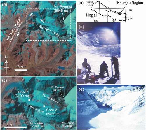
Figure 1. (a) Location map, (b), (c) satellite images, and (d), (e) photographs of the drilling site at the Western Cwm of the Khumbu Glacier in the Nepal Himalayas. The satellite images were acquired on 10 May 1999 by Landsat 5 TM. Locations of the drilling site of the ice cores on the glacier are shown. Photographs (d) and (e), which were taken during the expedition in 1980, show ice core drilling of core 1 and downward view of the glacier from the drilling site of core 2, respectively
Despite these studies on Khumbu Glacier, there is still a lack of information regarding its accumulation area. To understand the mass balance and formation process of the surface debris of the glacier, the accumulation process of snow and debris in the upper area of the glacier must be fully understood. Furthermore, the geochemistry of snow in the accumulation area may provide valuable information on local and global pollutants and atmospheric circulations of the upper troposphere (e.g., Kang et al. Citation2002, Citation2019; Hou et al. Citation2003; Kaspari et al. Citation2007). Because the accumulation area of the Khumbu Glacier is one of the main routes used to climb the summit of Mt. Everest, many climbers have walked through this area every year (Roch Citation1954). However, there have been only a few studies conducted in the accumulation area due to the severe conditions accompanying the fieldwork, including risks of high elevation (over 6,000 m a.s.l.), crevasses, and avalanches.
In 1980, two shallow ice cores were drilled on the Western Cwm of Khumbu Glacier. The Western Cwm is a snow plateau located in the accumulation area of the Khumbu Glacier at the elevation ranging from 6,000 to 7,000 m a.s.l. In addition to ice core drilling, direct sampling of aerosols was conducted at the same site and revealed the presence of abundant sulfate aerosol (Ono, Yamato, and Yoshida Citation1983). Most sulfate-containing aerosols were present in the form of hydrated sulfuric acid droplets rather than ammonium sulfate, which dominates in the lower troposphere, suggesting vertical stratification in the acidity of sulfate-containing aerosols in the troposphere. The ice cores were drilled originally to study such aerosols in the high-elevation area of the Himalayan region. However, they were found to contain abundant melt features and appeared to be unsuitable for study as aerosol records. Therefore, analysis of the ice cores was interrupted and the cores were stored in a cold room for more than thirty-six years. In 2016, we confirmed that the ice cores still remained in a frozen state in the cold room and decided to restart geochemical analyses of the ice cores to study accumulation processes of the Khumbu Glacier.
In this study, we describe the physical and chemical characteristics of two shallow cores drilled at different locations in the accumulation area of Khumbu Glacier in 1980. We analyze the mineralogical characteristics of the debris in the ice cores and discuss the spatial variability of the accumulation process of snow and debris on the glacier.
Study site and methods
The two ice cores were drilled with a hand augur in December 1980 at different elevations on the Western Cwm of the Khumbu Glacier in Nepal (27°58′51″ N, 86°53′36″ E, ) by members of the Japan Winter Everest Expedition. The expedition was led by a famous climber, Naomi Uemura, and was designed to conduct glaciological research as well as to reach the summit of Mt. Everest. Although the climb to the summit was not successful, two ice cores were successfully obtained in the Western Cwm. The Western Cwm is a flat snow plateau surrounded by high rock cliffs over 8,000 m a.s.l. including the south face of Mt. Everest and the north faces of Mts. Lhotse (8,516 m) and Nuptse (7,864 m). According to satellite observation, the velocity of glacier flow is in the range of 30 to 60 m year−1 in this area (Scherler, Leprince, and Strecker Citation2008).
Meteorological features in the area of Khumbu Valley are characterized by a typical summer monsoon climate (Bollasina, Bertolani, and Tartari Citation2002). A meteorological observation carried out at the Pyramid Meteorological Station (elevation: 5,050 m a.s.l.) nearby the Khumbu Glacier from 1994 to 1999 showed that nearly 90 percent of the annual precipitation occurs in the summer monsoon period (from June to October). Daily mean air temperature measured at the station is approximately 4°C and −10°C in summer and winter, respectively. Daily mean air temperature at the Western Cwm (at an elevation of 6,100 m) is estimated to be −1.8°C and −15.8°C in summer and winter, respectively, based on the lapse rate of air temperature (−0.0055°C m−1). Prevailing wind direction on the glacier is a valley wind coming from south–southwest throughout the year.
One of the ice cores was drilled at an elevation of 6,100 m a.s.l. down to 8.83 m below the surface (core 1). Another core was drilled at an elevation of 6,400 m a.s.l. down to 4.06 m below the surface (core 2). The diameter of the cores was 6 cm. The number of core pieces drilled was twenty-eight and seventeen for cores 1 and 2, respectively. All core pieces were wrapped in aluminum foil and then in plastic bags to avoid sublimation during transportation and storage. The ice cores were transported in a frozen state from the sites to the base camp and then moved to Kathmandu, the capital city of Nepal, by helicopter. The ice cores were stored in a freezer room in Kathmandu and were then transported to Japan as air cargo. The ice cores successfully arrived at the National Institute of Polar Research in Tokyo and have been stored in a cold room (−20°C). After being stored in the cold room for thirty-six years, the ice cores were transported to a cold laboratory at Chiba University in 2016 for geochemical analysis.
A visual stratigraphy of all core sections was recorded at the drilling site, and stratigraphy was recorded again in the cold laboratory at Chiba University to determine whether any deformation of the cores occurred during the long storage period. The stratigraphy recorded in this study was firn (layers consisting of granular snow grains), ice layers (transparent layers without snow grains), dust layers, and rock debris. We compared our records with those recorded after drilling and confirmed that there was no significant change in the stratigraphy between the two records, indicating that the ice cores were preserved without critical physical deformation during storage. In the cold room, all core pieces were weighed to determine their density. The density was calculated from the weight divided by the columnar volume of each core piece (6.0 cm in diameter). The density had an error of 10 percent or less due to the irregularities of the cross sections.
The core was then cut every 5 to 10 cm and used for analyses of oxygen- and hydrogen-stable isotopes, soluble ions, and pollen grains. We analyzed 125 and 40 samples for cores 1 and 2, respectively. Oxygen- and hydrogen-stable isotope ratios (δ18O and δD) were analyzed with a liquid water isotope analyzer (DLT-100, Los Gatos Research, California, USA) at Chiba University. The analytical precision of δ18O and δD measurements was 0.05 and 0.5 per mill, respectively. The soluble chemical ions, including five cations (Na+, NH4+, K+, Mg2+, and Ca2+) and three anions (Cl−, NO3−, and SO42−), were measured with ion chromatography (ICS1100, Thermo Fisher, MA, USA).
Pollen grain counting was conducted as described by Nakazawa et al. (Citation2005). A portion (10 mL) of the melted samples was filtered through a hydrophilic membrane filter with a pore size of 0.45 µm (JHWP01300, Millipore, Merck KGaA, Darmstadt, Germany). Then the pollen grains on the filter were counted under a fluorescence microscope (BH-51, Olympus, Tokyo, Japan). Because pollen grains have strong fluorescence under ultraviolet excitation, they can be easily counted using a microscope. To simplify the counting process and prevent pollen loss, the samples were not subjected to chemical treatment or centrifugation. Because of the limited volume of ice core samples available for the analysis, we counted only the major pollen grains in the samples.
The mineralogical composition of dust and debris in the ice cores was identified by powder X-ray diffraction analysis (XRD) using a Geigerflex RAD-2B (Rigaku, Tokyo, Japan) at Chiba University. Dust or debris samples were dried at 60°C and then powdered with agate mortar. The X-ray target was CuKα, the tube voltage was 40 kV, and the tube current was 25 mA. Scans were performed from 2° to 40° (2θ) at a rate of 2° (2θ) per minute.
Results
Stratigraphy and density of the ice cores and borehole temperature
The visual stratigraphy was distinctive between the two ice cores (). Core 1 consists mostly of firn layers (98 percent of the total core length) and a few ice layers (2 percent). There were four ice layers observed at depths of 4.17–4.22, 4.32, 4.62–4.66, and 6.53–6.58 m. Only one dust layer was observed at a depth of 7.27 m. In contrast, core 2 consisted mostly of refrozen ice layers (85 percent) and firn layers (15 percent). The firn layers, which were recorded as depth hoar after drilling, were observed only near the surface (0.00–0.40 m in depth). The core contained rock debris consisting of coarse stones and sands, which was not observed in core 1, at depths of 0.40–0.63, 1.16–1.23, and 3.38–3.97 m. The debris particles were mostly 0.10 to 2.0 mm in diameter, but particles larger than 1 cm were also observed. They showed various colors including black, white, transparent yellow, and green.
Figure 2. Selected photographs and physical properties of the two ice cores from the Western Cwm of Khumbu Glacier taken in a laboratory at Chiba University in 2016: (a) core 1: 4.19–4.43 m; (b) core 1: 7.58–7.88 m; (c) core 2: 0.39–0.64 m; (d) core 2: 1.63–1.73 m; (e) and (f) density, borehole temperature, and stratigraphy with snow grain size in firn layers for cores 1 and 2, respectively
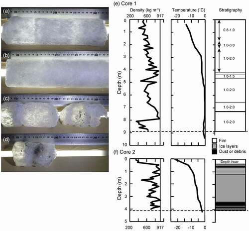
The mean densities for core 1 and core 2 were 637 and 738 kg m−3, respectively (). The density of core 1 generally increased with depth and showed the maximum value of 900 kg m−3 at a depth of 7.9 m. The density of core 2 largely increased at a depth of 0.45 m and fluctuated from 500 to 900 kg m−3.
The borehole temperature increased with depth in both drilling sites (). The temperature for core 1 was −14°C at the surface, which was the minimum in the profile. It increased to −3.0°C at 2.9 m and −0.5°C at 5.4 m and then stayed between −0.2°C and −0.7°C below 5.4 m. The borehole temperature for core 2 was generally lower than that for core 1, with −22.5°C at the surface, −14.5°C at 0.50 m, −10.5°C at 2.0 m, and −6.4°C at 4.2 m at the bottom of the borehole.
Stable isotope and chemical soluble ions
Oxygen- and hydrogen-stable isotopes of the ice cores showed no clear periodical fluctuation, but they partially changed in the profiles (, ). The oxygen isotope values (δ18O) ranged from −22.7 to −14.2 per mill for core 1 and from −24.0 to −18.2 per mill for core 2. Hydrogen-stable isotopes (δD) ranged from −170.2 to −90.4 per mill for core 1 and from −183.9 to −140.0 per mill for core 2. The mean isotope values were significantly higher for core 1 than for core 2 (δ18O: −18.5 vs. −21.4 per mill; δD: −134.7 vs. −163.3 per mill). There was a clear fluctuation in the oxygen-stable isotope ranging from −20 to −16 per mill in the upper part (0–4.5 m depth) of core 1. However, the fluctuation was not clear in the lower part (4.5–9.0 m) of the core. No periodical fluctuation was present in the stable isotopes of core 2.
Table 1. Oxygen-stable isotope and soluble ion concentrations in two ice cores from the Western Cwm of Khumbu Glacier. For comparison, the ice core data from the East Rongbuk Glacier (ERG, mean of the depth of 8.51–11.07 m corresponding to 1980–1975 AD, drilled in 1998) are shown (Hou et al. Citation2003)
Figure 3. Oxygen-stable isotope and major soluble ions for cores 1 and 2 on the Western Cwm of Khumbu Glacier
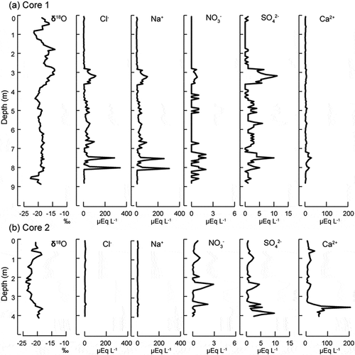
Analyses of major soluble ions showed that the ion concentrations were generally low, and the composition of the two cores was significantly different (, ). The major soluble ions in core 1 were Cl− and Na+, which accounted for 79 percent of the total ions. Their concentrations ranged from 0.99 to 339 µEq L−1 (mean = 27.6 µEq L−1) and from 0.30 to 304.46 µEq L−1 (mean = 25.8 µEq L−1) for Cl− and Na+, respectively. The mean concentrations of other ions in core 1 were all less than 5 µEq L−1. In contrast to core 1, the major soluble ion in core 2 was Ca2+, which accounted for 72 percent of the total ions analyzed. The concentration of Ca2+ in core 2 ranged from 3.6 to 205.1 µEq L−1 (mean = 25.9 µEq L−1). The mean concentrations of other ions in core 2 were below 4 µEq L−1.
The ion concentration profiles of both cores showed no clear periodical fluctuation, but an irregular pattern was observed in all ions (). Major peaks were observed at 3.2, 7.3, and 8.1 m for core 1 and 3.6 m for core 2.
Pollen grains
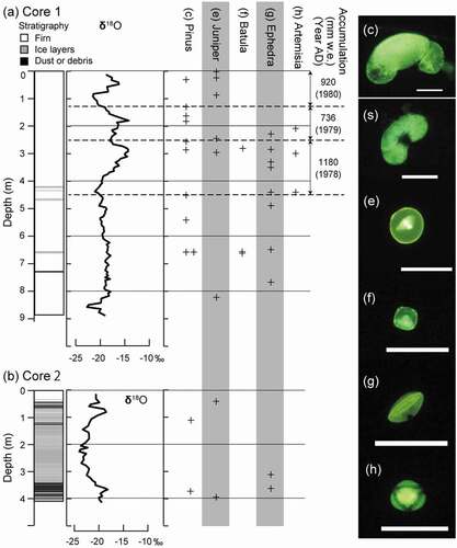
We found five major types of pollen grains in the ice cores, Pinus, Juniperus, Batula, Ephedra, and Artemisia (). The most abundant pollen type observed in the ice cores was Pinus. Pinus-type pollen includes various grain size ranging from 20 to 100 µm, suggesting multiple species in the samples. Because the number of pollen grains counted in samples was generally too small to represent the pollen grain concentration (less than three counts per 10 mL), the pollen grains present in each layer are shown (). Pinus, Juniperus, and Ephedra pollens were found in both cores 1 and 2, whereas Batula and Artemisia were found only in core 1. The appearance of pollen grains in the cores differed among the pollen types. The Pinus type most frequently appeared in core 1 and showed eight peaks. The peak at 6.5 m showed the highest pollen grain concentration (2.0 grains mL−1). The Pinus type tended to appear in the layers where the oxygen-stable isotope was higher. The number of layers (samples) showing Juniperus, Batula, Ephedra, and Artemisia pollen types in core 1 were six, two, eight, and three, respectively. There was no clear seasonality in the order of the appearance of pollen types in core 1.
Figure 4. Stratigraphy and profiles of oxygen-stable isotopes and pollen grains for (a) core 1 and (b) core 2 to determine annual layers. Due to lack of signal, those of only the upper 4 m of core 1 were determined. +Indicates the layer in which the pollen grains were found. Dashed line indicates the possible annual boundaries (spring). (c)–(f) Photographs of major pollen grains found in the ice cores observed with fluorescence microscopy: (c) Pinus (large type, likely Picea), (d) Pinus (small type), (e) Juniperus, (f) Batula, (g) Ephedra, and (h) Artemisia. Scale bar = 50 µm
Mineralogical analysis of dust and debris in ice cores
Dust and debris in the cores were of various sizes, shapes and colors of the mineral particles (). Specifically, debris in core 2 was generally large in size, and some of the debris exceeded 1 cm in diameter. The minerals were transparent, white, black, and pink.
Figure 5. XRD spectra and photographs of debris contained in the two ice cores of Khumbu Glacier: (a) core 1; (b) core 2; (c) and (d) debris contained in core 2. Scale bar = 0.5 mm
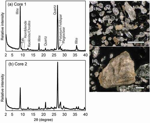
The XRD spectra of four dust or debris samples were analyzed, which were from 7.27 m in core 1 and from 0.40 to 0.63 m, 1.16 to 1.23 m, and 3.38 to 3.97 m in core 2. The spectra showed peaks of several silicate minerals and were generally similar among the dust/debris samples of cores 1 and 2 (). The observed peaks in the spectra were identified as illite (8.9°, 12.5°, 17.8°, and 35.9°), hornblende (10.5°), chlorite (12.5°, 18.5°), kaolinite (12.5°, 25.2°), quartz (26.7°, 21.0°, 39.7°), potassium feldspar (27.2°), and plagioclase (28.2°). Specifically, the peaks of illite and quartz were relatively intense, suggesting that these two minerals were abundant in the samples. A small peak of talc (9.5°) appeared only in core 1.
Discussion
Difference in the snow accumulation process at the two drilling sites
Despite the high elevation of the drilling sites (over 6,000 m a.s.l.), melt features were present in both cores and were particularly abundant in core 2. Although the borehole temperature was below −10°C near the surface, the temperature increased in the deeper part of the hole up to near 0°C. The low temperature near the surface is likely to reflect the air temperature during winter. The increase in temperature with depth suggests a warm temperature above the melting point during summer. The near-zero temperature at the bottom of borehole of core 1 (9.4 m deep) appears to be too high to indicate the annual mean temperature at the drilling site, which can be estimated as approximately −9°C based on the mean annual air temperature at 4,420 m a.s.l. (0.12°C in 1974 at the Lhajung Station of Khumbu Valley; Inoue Citation1976) and a lapse rate (−0.0055°C m−1). The high borehole temperature is probably caused by latent heat derived from refreezing of meltwater percolated to this layer.
The difference in stratigraphy between cores 1 and 2 suggests that the snow accumulation process differed at the two drilling sites. The stratigraphy of core 2 showed unstratified layers with abundant refrozen ice and rock debris, suggesting that the snow was mostly supplied by avalanche at this site. Because the debris in the ice core was too large to be supplied by wind, it was likely derived from the rock cliffs over the drilling site with avalanches. Ice layers in ice cores are usually regarded as refrozen ice of percolated meltwater from the snow surface produced by warm air temperature and their abundance is indicative of summertime air temperatures (e.g., Okamoto et al. Citation2011). However, despite the presence of abundant ice layers in core 2, there was only a small ice layer in core 1, which was drilled at a lower elevation site on the glacier. Because air temperature is usually warmer at the lower site, more ice layers would be expected in core 1. This inconsistency suggested that the ice layers in core 2 were not simply derived from the surface snowmelt produced by warm air mass but that they were likely derived from meltwater produced by the rock debris, which could absorb solar radiation and become warm enough to the melt snow around it. The topographic effect of the Western Cwm, surrounded by high rock cliffs, which reflect solar radiation and emit longwave radiation, may also enhance the snow melting at the site of core 2. When compared to core 2, the stratified layers of core 1 suggest that snow was mostly supplied by precipitation at the site.
The difference in the snow source between the two drilling sites was consistent with the topography and locations of the drilling sites in the Western Cwm. The drilling site of core 2 was located at the center of the Western Cwm and was close to the south face of Mt. Everest, which is a rock cliff over 8,000 m. Snow and rock debris of avalanches from the south face appear to accumulate in this area. In contrast, the site of core 1 was located downstream of the Western Cwm and away from the south face. There is also a vertical rock cliff at this site, but their height and area are much smaller than at the south face, and thus the core 1 site showed a lower frequency of avalanches.
The difference in the mean stable isotopes between the two ice cores also suggests that the source of snow was different between the two drilling sites. The difference in oxygen-stable isotopes between the sites (2.0 per mill) is too large to be explained by the effect of elevation on precipitation. Stable isotopes of precipitation usually change with altitude. According to Wen et al. (Citation2012), the oxygen-stable isotope of precipitation decreased by 0.15 to 0.17 per mill with an increase in elevation of 100 m in the southern Himalayan region. Based on this lapse rate of the isotope, the effect of elevation (300 m) on the isotope values of precipitation between the two drilling sites would be as much as 0.5 per mill, which is much smaller than the difference in mean isotope values between the two cores. The large difference in stable isotopes of the ice cores can be explained by the snow accumulation of avalanches. If the snow was supplied by an avalanche originating from a higher elevation site, its stable isotope value would be lower than that of precipitation at the site. Based on the lapse rate of stable isotopes with elevation (−0.15 to −0.17 per mill per 100 m), the difference in the mean stable isotopes of the two cores was equivalent to an difference in elevation of 1,100 to 1,300 m. Therefore, the snow at the drilling site of core 2 (6,400 m) was possibly supplied from an elevation of 7,500 to 7,700 m a.s.l. by avalanches.
The difference in chemical solutes between cores 1 and 2 was likely due to the postdepositional process. Na+ and Cl− were generally dominant for core 1 but Ca2+ was most dominant for core 2. Analyses of fresh snow samples collected from the north side of Mt. Everest between 5,600 and 7,100 m a.s.l. (Jenkins et al. Citation1987) showed that Ca2+ is the most abundant soluble ion in this area. However, because the cores consisted mostly of refrozen ice, the significant Ca2+ peaks were probably caused by leaching of the solutes from the rock debris contained in the ice core. As the stratigraphy of the abundant refrozen ice layers and debris contents in core 2 shows, chemical leaching was likely to occur. Thus, the difference in the chemical solutes between the two cores was likely caused by significant melt and debris content in core 2.
Geochemical characteristics of ice cores
After drilling the ice cores used in this study, deeper ice cores were drilled at a similar elevation on the East Rongbuk Glacier (ERG) located on the northern slope of Mt. Everest, approximately 8 km away from our study site. An 80.4-m ice core was drilled at 6,450 m in 1998 (Kang et al. Citation2002), and another 109-m ice core was drilled at 6,518 m in 2002 (Kaspari et al. Citation2007). The mean oxygen-stable isotope values in the period of 1980 to 1975 of the ERG core were −16.2 per mill (Hou et al. Citation2002, Citation2003), which is higher than those of core 1 (−18.5 per mill) and core 2 (−21.4 per mill) in this study (). The lower isotope values of the ice cores in this study relative to the ERG core may be due to the difference in the isotope fractionation process between northern and southern slopes of the mountain.
The characteristics of chemical solutes appear to have differed between the ice cores of the Western Cwm in this study and the ERG cores (). The presence of melt features suggests that the solutes in the ice cores of this study were removed by melt as shown in many studies (Hou and Qin Citation2002; Hou et al. Citation2002). However, the concentrations of Mg2+, Ca2+, and SO42− were comparable between the ice cores in this study and the ERG cores. Abundant Mg2+ and Ca2+ were probably caused by leaching of the solutes from the rock debris contained in the ice core. The presence of SO42− in the ice core suggests an abundant supply of sulfate aerosols in the high-elevation area, which is consistent with in situ aerosol collection at the Western Cwm (Ono, Yamato, and Yoshida Citation1983). The concentrations of Na+ and Cl− were also higher in the Western Cwm compared with those of the ERG. The higher Na+ and Cl− concentrations may have been due to a strong marine contribution by the monsoon circulation, which was suggested by previous studies in the southern slope of the Himalayas (Wake and Mayewski Citation1993; Marinoni et al. Citation2001). The Na+:Cl− ratio for core 1 was 0.93, which is close to the sea salt ratio (0.86), supporting the idea. The lower concentrations of NO3− and NH4+ in the Western Cwm are probably due to removal by melting.
Annual layers of ice cores
Because of the presence of melt features in both of the ice cores, it is difficult to determine the annual layers of the ice cores. In particular, core 2 mostly consisted of unstratified layers of refrozen ice, and thus the core is unable to be dated. In contrast, core 1 showed little melt features and three clear peaks of oxygen-stable isotopes above 4 m in depth, which probably corresponded to the annual layer boundaries, although no clear fluctuation remained below this depth. As oxygen-stable isotope of precipitation in the Khumbu region shows seasonal fluctuation with the winter maximum and summer minimum controlled by the amount of precipitation (Wushiki Citation1977) and has been used to determine the annual layers of the ice core from the ERG (Hou et al. Citation2003); the three clear peaks of oxygen-stable isotopes in core 1 are likely to corresponded to winter snow. The lack of fluctuation below the 4 m depth of the core is likely to result from meltwater percolation, which is consistent with the bore temperature of near 0°C below this depth.
Pollen grains have also been used to determine annual layers in mountain ice cores because they are abundantly dispersed in the atmosphere during certain seasons (e.g., Nakazawa et al. Citation2005; Takeuchi et al. Citation2019). However, the concentration of pollen grains in the cores analyzed in this study was generally lower than those of the other ice cores drilled in Asian high mountains, and thus the fluctuation in pollen grain concentration cannot be used in these cores. Despite the low concentration of pollen grains, the Pinus type pollen was most abundant and periodically appeared in core 1. The Pinus pollens were likely to be Pinus wallichiana, which is commonly distributed below an elevation of 3,600 m in the southern slope of Himalayas and usually produces pollens in spring (Garbarino et al. Citation2014); thus, they are possibly supplied to the Western Cwm from downstream of the Khumbu valley by the prevailing wind from the south. This pollen type appeared at the layers just above the higher peaks of stable isotopes (spring), which is consistent with the season of pollen dispersion of the species.
The annual accumulations obtained from the isotope and pollen signals in the upper part of core 1 were 0.92, 0.74, and 1.18 m of water equivalent (w.e.) for years 1980, 1979, and 1978 (). The annual accumulation from the ERG ice core drilled at 6,518 m a.s.l. was 0.52 m w.e. (Hou et al. Citation2003), which was lower than that obtained in this study. Miller, Leventhal, and Libby (Citation1965) showed that the annual accumulation rate was 1.7 m w.e. on average from 1954 to 1962 in the Western Cwm on the basis of analysis of the tritium content in ice samples collected from the 20-m-deep crevasse wall at 6,160 m a.s.l., which was almost twice the value obtained in this study. As the study suggests, the snow deposition is likely to be spatially heterogeneous in the Western Cwm due to accumulation by avalanche and wind deposition, and thus the accumulation rates obtained in this study are likely to show uncertainty and should be further evaluated.
Source of rock debris in the ice core
Mineralogical analyses of the debris in the ice core revealed that they were mainly derived from the south face of Mt. Everest over the Western Cwm. The rock cliff can be divided into three main geological units: the Mt. Jolmo Lungma Formation at the top of Mt. Everest, the North Col Formation in the middle part of the south face between 7,000 and 8,600 m a.s.l., and the Rongbuk Formation at the lower part of the cliff (e.g., Carosi et al. Citation1998). Each geological unit has different mineralogical compositions: the Mt. Jolmo Lungma Formation mostly consists of limestones, whereas the North Col Formation consists of biotite–chlorite phyllite, biotite–calcite metagreywackes, impure quartzite with crystalline limestone layers, and calc–silicate rocks. The Rongbuk Formation consists of biotite–muscovite gneiss, leucogranite, and migmatite (Carosi et al. Citation1998; Searle et al. Citation2003). The mineralogical compositions of the debris in core 2 revealed by the XRD analyses showed that they contained two major minerals of illite and quartz but no calcite. The result is accordance with that for the North Col Formation. Therefore, most of the debris contained in core 2 was likely derived from the middle part of the south face of Mt. Everest but not from the higher part above 8,600 m (i.e., Mt. Jolmo Lungma Formation).
The mineralogical composition of dust in core 1 was similar to the debris of core 2, but the peak of illite was weaker than that of core 2, thereby suggesting low contents of illite or mica in the dust of core 1. The drilling site of core 1 was distant from the south face of Mt. Everest but was surrounded by the rock cliffs of the Rongbuk Formation. Because the Rongbuk Formation contains less mica compared to the North Col Formation, the mineralogical composition of core 1 indicates that the dust is likely to be derived from the rock cliff of this Rongbuk Formation.
Supraglacial debris covering the ablation area of the Khumbu Glacier originated mostly from rock debris incorporated in glacial ice in the accumulation area (e.g., Hambrey et al. Citation2008). The mineralogical composition of the supraglacial debris could improve our understanding of the formation process of the supraglacial debris, glacier flow, and kinematic history of the glacier. Fushimi et al. (Citation1980) investigated the longitudinal zonal distributions of supraglacial debris on the ablation area of the Khumbu Glacier. They showed that schistose debris was mainly distributed on the right side of the ablation area, whereas granitic debris was on the left side. They presumed that both debris types originated mainly from the Western Cwm, and the schistose debris originated from the south face of Mt. Everest, corresponding to the North Col Formation; however, the granitic debris is from the north face of Mt. Nuptse, corresponding to the Rongbuk Formation. Casey, Kääb, and Benn (Citation2012) analyzed the mineralogical compositions of supraglacial debris on Khumbu Glacier analyzed using XRD. The study showed that mica, quartz, and feldspar are the most abundant in debris, and the composition varies spatially within the ablation area. This composition roughly consisted of the debris in core 2, supporting that the debris originated from the Western Cwm. Although their quantitative contribution to the debris cover is not clear yet, mineralogical information of the debris in the ice core would be useful in understanding the formation process of the debris cover of the glacier.
Conclusions
The physical and geochemical characteristics of two shallow ice cores drilled in the Western Cwm of Khumbu Glacier in 1980 were analyzed. Despite storage of the ice cores in a cold room for more than thirty-six years, no significant change in their stratigraphy was observed, which allowed us to restart the analyses. The results showed that the two ice cores (cores 1 and 2) drilled at different elevations had distinct characteristics. The visual stratigraphy of core 1 consisted mostly of firn layers, but core 2 consisted mostly of refrozen ice layers. The mean oxygen-stable isotope was significantly lower in core 2 than in core 1, and the composition of major soluble ions also differed between the two ice cores. The distinct stratigraphy and geochemical characteristics suggest that the snow accumulation process differed between the two drilling sites. The snow at the lower site (core 1) was likely supplied by precipitation, but the snow at the higher site (core 2) was likely supplied by avalanches from the rock cliffs. The lower oxygen-stable isotope of core 2 was likely caused by the avalanche deposits, which were derived from snow at higher elevation sites. The abundant melt features in core 2 were probably due to the topographic effect of Western Cwm, which is surrounded by high rock cliffs that reflect solar radiation and emit longwave radiation. Annual layers were determined only in the upper part of core 1 using oxygen-stable isotopes and pollen grains in the ice core. The annual net accumulation obtained for three years ranged from 0.74 to 1.18 m w.e. per year. The mineralogical characteristics of debris in core 2 were in accordance with those of the North Col Formation, which were distributed in the middle part of the south face of Mt. Everest; this result indicated that the debris was supplied from the south face by avalanches. The results for the two ice cores revealed large spatial variability of depositional processes of snow and debris on the Western Cwm and will likely improve our understanding of the transportation and formation processes of supraglacial debris in the ablation area of Khumbu Glacier. Furthermore, redrilling of ice cores at the Western Cwm in the future and comparison with the data shown in this study would be useful to assess the effect of recent climate warming on the high-elevation mountain environment in the Himalayas.
Acknowledgments
We thank Shuji Fujita and Yoriko Ishida for proper control of the ice core samples in National Institute of Polar Research. The drilling operation was supported by Naomi Uemura and Hisashi Koaze. Transportation of the ice cores to Japan was logistically supported by Yasuo Ishimoto. We thank three anonymous reviewers for constructive comments that helped to improve this article.
Disclosure statement
No potential conflict of interest was reported by the authors.
Additional information
Funding
References
- Bollasina, M., L. Bertolani, and G. Tartari. 2002. Meteorological observations at high altitude in the Khumbu Valley, Nepal Himalayas, 1994–1999. Bulletin of Glaciological Research 19:1–12.
- Carosi, R., B. Lombardo, G. Molli, G. Musumeci, and P. C. Pertusati. 1998. The South Tibetan detachment system in the Rongbuk valley, Everest region. Deformation features and geological implications. Journal of Asian Earth Science 16 (2–3):299–311. doi:https://doi.org/10.1016/S0743-9547(98)00014-2.
- Casey, K. A., A. Kääb, and D. I. Benn. 2012. Geochemical characterization of supraglacial debris via in situ and optical remote sensing methods: A case study in Khumbu Himalaya, Nepal. The Cryosphere 6 (1):85. doi:https://doi.org/10.5194/tc-6-85-2012.
- Fujita, K., and A. Sakai. 2014. Modelling runoff from a Himalayan debris-covered glacier. Hydrology and Earth System Sciences 18 (7):2679–94. doi:https://doi.org/10.5194/hess-18-2679-2014.
- Fushimi, H., M. Yoshida, O. Watanabe, and B. P. Upadhyay. 1980. Distributions and grain sizes of supraglacial debris in the Khumbu Glacier, Khumbu region, east Nepal. Seppyo 41:18–25. doi:https://doi.org/10.5331/seppyo.41.Special_18.
- Garbarino, M., E. Lingua, R. Marzano, C. Urbinati, D. Bhuju, and M. Carrer. 2014. Human interactions with forest landscape in the Khumbu valley, Nepal. Anthropocene 6:39–47. doi:https://doi.org/10.1016/j.ancene.2014.05.004.
- Gibson, M. J., T. D. Irvine‐Fynn, P. Wagnon, A. V. Rowan, D. J. Quincey, R. Homer, and N. F. Glasser. 2018. Variations in near‐surface debris temperature through the summer monsoon on Khumbu Glacier, Nepal Himalaya. Earth Surface Processes and Landforms 43 (13):2698–714. doi:https://doi.org/10.1002/esp.4425.
- Hambrey, M. J., D. J. Quincey, N. F. Glasser, J. M. Reynolds, S. J. Richardson, and S. Clemmens. 2008. Sedimentological, geomorphological and dynamic context of debris-mantled glaciers, Mount Everest (Sagarmatha) region, Nepal. Quaternary Science Reviews 27 (25–26):2361–89. doi:https://doi.org/10.1016/j.quascirev.2008.08.010.
- Hou, S., and D. Qin. 2002. The effect of postdepositional process on the chemical profiles of snow pits in the percolation zone. Cold Regions Science and Technology 34 (2):111–16. doi:https://doi.org/10.1016/S0165-232X(01)00065-9.
- Hou, S., D. Qin, D. Zhang, S. Kang, P. A. Mayewski, and C. P. Wake. 2003. A 154 a high-resolution ammonium record from the Rongbuk Glacier, north slope of Mt. Qomolangma (Everest), Tibet–Himal region. Atmospheric Environment 37 (5):721–29. doi:https://doi.org/10.1016/S1352-2310(02)00582-4.
- Hou, S., D. Qin, D. Zhang, J. Ren, S. Kang, P. A. Mayewski, and C. P. Wake. 2002. Comparison of two ice-core chemical records recovered from the Qomolangma (Mount Everest) region, Himalaya. Annals of Glaciology 35:266–72. doi:https://doi.org/10.3189/S0260305500268110.
- Inoue, J. 1976. Climate of Khumbu Himal. Seppyo 38:66–73. doi:https://doi.org/10.5331/seppyo.38.Special_66.
- Inoue, J., and M. Yoshida. 1980. Ablation and heat exchange over the Khumbu Glacier. Seppyo 41:26–33. doi:https://doi.org/10.5331/seppyo.41.Special_26.
- Iwata, S., O. Watanabe, and H. Fushimi. 1980. Surface morphology in the ablation area of the Khumbu glacier. Journal of the Japanese Society of Snow and Ice 41 (Special):9–17. doi:https://doi.org/10.5331/seppyo.41.Special_9.
- Jenkins, M. D., J. I. Drever, R. G. Reider, and T. Buchanan. 1987. Chemical composition of fresh snow on Mount Everest. Journal of Geophysical Research 92 (D9):10999–1002. doi:https://doi.org/10.1029/JD092iD09p10999.
- Kang, S., D. Qin, P. A. Mayewski, D. Qin, S. Hou, D. Zhang, J. Ren, and K. Kreutz. 2002. Glaciochemical records from a Mt. Everest ice core: Relationship to atmospheric circulation over Asia. Atmospheric Environment 36 (21):3351–61. doi:https://doi.org/10.1016/S1352-2310(02)00325-4.
- Kang, S., Q. Zhang, Y. Qian, Z. Ji, C. Li, Z. Cong, Y. Zhang, J. Guo, W. Du, J. Huang, et al. 2019. Linking atmospheric pollution to cryospheric change in the Third Pole region: Current progress and future prospects. National Science Review 6 (4):796–809. doi:https://doi.org/10.1093/nsr/nwz031.
- Kaspari, S., P. Mayewski, S. Kang, S. Sneed, S. Hou, R. Hooke, K. Kreutz, D. Introne, M. Handley, K. Maasch, et al. 2007. Reduction in northward incursions of the South Asian monsoon since ∼1400 AD inferred from a Mt. Everest ice core. Geophysical Research Letter 34 (16). doi: https://doi.org/10.1029/2007GL030440.
- Marinoni, A., S. Polesello, C. Smiragglia, and S. Valsecchi. 2001. Chemical composition of fresh snow samples from the southern slope of Mt. Everest region (Khumbu-Himal region, Nepal). Atmospheric Environment 35:3183–90. doi:https://doi.org/10.1016/S1352-2310(00)00488-X.
- Miles, K. E., B. Hubbard, D. J. Quincey, E. S. Miles, T. D. Irvine-Fynn, and A. V. Rowan. 2019. Surface and subsurface hydrology of debris-covered Khumbu Glacier, Nepal, revealed by dye tracing. Earth and Planetary Science Letter 513:176–86. doi:https://doi.org/10.1016/j.epsl.2019.02.020.
- Miller, M. M., J. S. Leventhal, and W. F. Libby. 1965. Tritium in Mt. Everest ice -Annual glacier accumulation and climatology at great equatorial altitudes. Journal of Geophysical Research 70 (16):3885–88. doi:https://doi.org/10.1029/JZ070i016p03885.
- Nakawo, M., S. Iwata, O. Watanabe, and M. Yoshida. 1986. Processes which distribute supraglacial debris on the Khumbu Glacier, Nepal Himalaya. Annals of Glaciology 8:129–31. doi:https://doi.org/10.3189/S0260305500001294.
- Nakawo, M., and G. J. Young. 1982. Estimate of glacier ablation under a debris layer from surface temperature and meteorological variables. Journal of Glaciology 28 (98):29–34. doi:https://doi.org/10.3189/S002214300001176X.
- Nakazawa, F., K. Fujita, N. Takeuchi, T. Fujiki, J. Uetake, V. Aizen, and M. Nakawo. 2005. Dating of seasonal snow/firn accumulation layers using pollen analysis. Journal of Glaciology 51 (174):483–90. doi:https://doi.org/10.3189/172756505781829179.
- Okamoto, S., K. Fujita, H. Narita, J. Uetake, N. Takeuchi, T. Miyake, F. Nakazawa, V. B. Aizen, S. A. Nikitin, and M. Nakawo. 2011. Reevaluation of the reconstruction of summer temperatures from melt features in Belukha ice cores, Siberian Altai. Journal of Geophysical Research, Atmosphere 116 (D2). doi: https://doi.org/10.1029/2010JD013977.
- Ono, A., M. Yamato, and M. Yoshida. 1983. Molecular state of sulfate aerosols in the remote Everest highlands. Tellus 35B (3):197–205. doi:https://doi.org/10.1111/j.1600-0889.1983.tb00024.x.
- Roch, A. 1954. The glaciers, snow and avalanches of Mount Everest. Journal of Glaciology 2 (16):428–30. doi:https://doi.org/10.3189/002214354793702416.
- Rowan, A. V., D. L. Egholm, D. J. Quincey, and N. F. Glasser. 2015. Modelling the feedbacks between mass balance, ice flow and debris transport to predict the response to climate change of debris-covered glaciers in the Himalaya. Earth and Planetary Science Letter 430:427–38. doi:https://doi.org/10.1016/j.epsl.2015.09.004.
- Sakai, A., N. Tekeuchi, K. Fujita, and M. Nakawo 2000. Role of supraglacial ponds in the ablation process of a debris-covered glacier in the Nepal Himalayas. In Debris-Covered Glaciers (Proceedings of a workshop held at Seattle Washington, USA, September 2000), (Vol. 265, pp. 119–30). IAHS Publication.
- Salerno, F., S. Thakuri, G. Tartari, T. Nuimura, S. Sunako, A. Sakai, and K. Fujita. 2017. Debris-covered glacier anomaly? Morphological factors controlling changes in the mass balance, surface area, terminus position, and snow line altitude of Himalayan glaciers. Earth and Planetary Science Letter 471:19–31. doi:https://doi.org/10.1016/j.epsl.2017.04.039.
- Scherler, D., S. Leprince, and M. R. Strecker. 2008. Glacier-surface velocities in alpine terrain from optical satellite imagery—Accuracy improvement and quality assessment. Remote Sensing of Environment 112 (10):3806–19. doi:https://doi.org/10.1016/j.rse.2008.05.018.
- Searle, M. P., R. L. Simpson, R., . D. Law, R. R. Parrish, and D. J. Waters. 2003. The structural geometry, metamorphic and magmatic evolution of the Everest massif, High Himalaya of Nepal–South Tibet. Journal of the Geological Society 160 (3):345–66. doi:https://doi.org/10.1144/0016-764902-126.
- Takeuchi, N., S. Sera, K. Fujita, V. B. Aizen, and J. Kubota. 2019. Annual layer counting using pollen grains of the Grigoriev ice core from the Tien Shan mountains, central Asia. Arctic, Antarctic, and Alpine Research 51 (1):299–312. doi:https://doi.org/10.1080/15230430.2019.1638202.
- Wake, C. P., and P. A. Mayewski 1993. The spatial variation of Asian dust and marine aerosol contributions to glaciochemical signals in central Asia. In Snow and glacier hydrology (Proceedings of the Kathmandu symposium), Vol. 218, pp. 385. Kathmandu, Nepal: IAHS Publication.
- Wen, R., L. D. Tian, Y. B. Weng, Z. F. Liu, and Z. P. Zhao. 2012. The altitude effect of δ 18O in precipitation and river water in the Southern Himalayas. Chinese Science Bulletin 57 (14):1693–98. doi:https://doi.org/10.1007/s11434-012-4992-7.
- Wushiki, H. 1977. Deuterium content in the Himalayan precipitation at Khumbu District observed in 1974–1975. Seppyo 39:50–56. doi:https://doi.org/10.5331/seppyo.39.Special_50.